Land Use & Urban Design Workshop Summary - San … Use & Urban Design Workshop Summary . ... The...
23
1 Land Use & Urban Design Workshop Summary Workshop Date: September 17, 2012 Summary Prepared: October 12, 2012 INTRODUCTION In November 2010, the City of San Diego (City) initiated an update to the Old Town San Diego Community Plan. A Community Plan Update Advisory Committee (Advisory Committee) was formed to provide the City and the community plan update consultants with input throughout the plan update process. Since November 2010, 13 Advisory Committee meetings have been held. On September 27, 2011, the City held the first major public meeting on the effort, inviting residents, business owners, and members of the Advisory Committee for a Charrette. The Charrette was designed to get feedback on key issues and opportunities for the City to consider throughout the planning process. On September 17, 2012, members of the Advisory Committee for the Old Town San Diego Community Plan Update (Community Plan Update) and interested residents, business owners, and others convened for a second public meeting, the Community Plan Update Workshop (Workshop). The Workshop was designed to allow attendees to have an opportunity to hear a presentation on the community plan update, participate in facilitated discussions about key areas in the community, and provide input on specific policies and goals for the Plan Update. The Workshop was held at the Harold J. Ballard Parent Center Auditorium at 2357 Congress Street, in Old Town, from 4 to 8 p.m. The agenda for the Workshop was as follows: Update Community and Stakeholders on the Community Plan Update and where the City is in the process Review: o Draft Land Use Map o Sub-District Map o Key Goals, Policies, Guidelines Receive Feedback on all materials in order to: o Finalize Draft Plan o Proceed with Traffic Modeling o Proceed with writing Plan Document MEETING ANNOUCEMENT AND ATTENDANCE The Workshop was announced in local papers and community newsletters, (both digital and hard-copy versions), on the City’s website, in direct mailings to property owners within the community plan area, and through numerous email blasts. More than 40 attended the Workshop, including Old Town residents, business and property owners, and other stakeholders, as well as the consultant team members, staff from City, Metropolitan Transit System (MTS), and San Diego Association of Governments
Transcript of Land Use & Urban Design Workshop Summary - San … Use & Urban Design Workshop Summary . ... The...

1
Land Use & Urban Design Workshop Summary Workshop Date: September 17, 2012 Summary Prepared: October 12, 2012 INTRODUCTION In November 2010, the City of San Diego (City) initiated an update to the Old Town San Diego Community Plan. A Community Plan Update Advisory Committee (Advisory Committee) was formed to provide the City and the community plan update consultants with input throughout the plan update process. Since November 2010, 13 Advisory Committee meetings have been held. On September 27, 2011, the City held the first major public meeting on the effort, inviting residents, business owners, and members of the Advisory Committee for a Charrette. The Charrette was designed to get feedback on key issues and opportunities for the City to consider throughout the planning process. On September 17, 2012, members of the Advisory Committee for the Old Town San Diego Community Plan Update (Community Plan Update) and interested residents, business owners, and others convened for a second public meeting, the Community Plan Update Workshop (Workshop). The Workshop was designed to allow attendees to have an opportunity to hear a presentation on the community plan update, participate in facilitated discussions about key areas in the community, and provide input on specific policies and goals for the Plan Update. The Workshop was held at the Harold J. Ballard Parent Center Auditorium at 2357 Congress Street, in Old Town, from 4 to 8 p.m. The agenda for the Workshop was as follows:
Update Community and Stakeholders on the Community Plan Update and where the City is in the process
Review: o Draft Land Use Map o Sub-District Map o Key Goals, Policies, Guidelines
Receive Feedback on all materials in order to:
o Finalize Draft Plan o Proceed with Traffic Modeling o Proceed with writing Plan Document
MEETING ANNOUCEMENT AND ATTENDANCE The Workshop was announced in local papers and community newsletters, (both digital and hard-copy versions), on the City’s website, in direct mailings to property owners within the community plan area, and through numerous email blasts. More than 40 attended the Workshop, including Old Town residents, business and property owners, and other stakeholders, as well as the consultant team members, staff from City, Metropolitan Transit System (MTS), and San Diego Association of Governments

2
(SANDAG). Copies of the Workshop meeting announcement, press release and direct mail are included in Appendix A. Old Town Community Plan Update Workshop Summary Upon arrival to Ballard Parent Center, workshop attendees were asked to sign in and take a name tag, were provided an overview of the workshop format and background material, as well as a comment card. Attendees were directed to be seated at one of the four focus area stations. MEETING ACTIVITIES – WELCOME AND PRESENTATION Kristen Byrne, Vice President of Public Affairs with MJE, welcomed attendees and provided an overview of the workshop agenda and format. Tait Galloway, Project Manager with the City of San Diego, provided an overview of the Community Plan Update process and the goals for the community. Christine Babla, Urban Designer with AECOM, gave an overview of the evening’s facilitated focus areas, as well as some of the key issues to consider at each focus area station. FOCUS AREA DISCUSSIONS Following the presentation, City staff and members of the consultant team facilitated group discussions at four separate stations. The four stations covered the following topics:
Focus Area 1: North Focus Area 2: Central Core Focus Area 3: South Focus Area 4: Design Guidelines
A facilitator and note taker were assigned to each focus area station, to summarize comments and feedback, and address questions from the attendees. For Focus Areas 1 through 3, facilitators provided attendees with an overview of goals for the focus area, reviewed a series of display boards and handouts, and discussed specific questions about potential opportunities in each focus area. Display boards included maps comparing existing land uses with Community Plan land uses and proposed land uses for the Community Plan Update. This was helpful in demonstrating potential land use changes in the community that would result from the adoption of the plan. For Focus Area 4, a facilitator provided an overview of the community sub-districts and key design guidelines, and sought input on guidelines, potential locations for gateways, and potential locations for streetscape improvements within the community. Feedback from the four focus groups is summarized below. Additionally, photos from the Workshop are provided in Appendix B, and the comments received at the Workshop are included for reference in Appendix C.

3
FOCUS AREA 1: NORTH Old Town Transit Center (OTTC)
The priority at OTTC is additional parking. An expanded parking structure should be built at the transit center that can serve both the community and transit users.
Other uses (residential) at OTTC are acceptable, but should not minimize the potential for transit/parking use.
Land Use Very few people in the community
realize that parking is available at the Caltrans building on evenings and weekends. The City should consider wayfinding signage or education efforts to communicate that parking resource.
Residential may not be appropriate for this area due to air quality issues. However, the community could benefit from more land designated to accommodate residential uses, and it is good planning to connect housing with transit. Residential could be in high demand, if environmental issues, including noise and air quality, and parking needs are addressed.
The community plan should consider the opportunity to create a parking lot or structure at the Navy owned property on Pacific Highway (north of Taylor Street), should that property ever become available.
Mobility Increased trolley service, along with additional rail service, could cause problems
because of the at-grade rail crossing at Taylor Street. There should be a long-term solution to create a grade-separation at the Taylor Street rail crossing. The community plan should consider alternative traffic patterns and pedestrian connections near the Taylor grade crossing to improve mobility.
The comments received at the Workshop are included for reference in Appendix C.

4
FOCUS AREA 2: CENTRAL CORE Old Caltrans Office Building
Some feedback indicated that the property with the Old Caltrans District 11 office building (south side of Taylor Street) should be designated as a public/institutional use, or as part of the Old Town San Diego State Historic Park, while others thought that there was potential for a commercial, mixed-use and/or parking use on the property.
Land Use
There was general consensus that the core land uses should include mixed-use with residential and commercial.
The community should retain residential uses.
There are concerns about lot consolidation and development pressure in this area.
Mobility Parking is a major issue within the
core area. Some feedback indicated that 2-hour parking limits on Congress Street and
Mason Street has caused parking issues, while other feedback indicated that time limits on parking could be helpful as it would encourage turn-over of spaces.
There is a need for directional signage to parking resources within the community.
The comments received at the Workshop are included for reference in Appendix C.

5
FOCUS AREA 3: SOUTH Fremont School/Ballard Parent Center
There was general consensus that this area could be a good location for a school or educational uses, park, and/or commercial and residential mixed-use should the property ever become available.
There was a range of thinking concerning the potential for additional parking at this property should it ever become available. There were recommendations that this property should be used for a parking structure potentially with other uses. There were some concerns that placing parking resources at this location would cause impacts to local circulation and pedestrian and bicycle safety.
There should be wayfinding signage from the freeway to parking resources throughout the community.
Larger Parcels in the Hortensia Sub-District
The community plan should allow for a mix of small office and residential uses.
The community plan could include some flexibility to allow larger buildings, for example, with smaller-scale facades to break up the massing with community planning group review. The community plan should
provide direction for how existing larger buildings fit the scale of the community should they ever redevelop.
Smaller Parcels in the Hortensia Sub-District
The community plan should allow for a mix of small office and residential in this sub-district.
Jefferson Sub-District
Residential uses should be maintained in this area Do not allow future commercial uses in this area.
The comments received at the Workshop are included for reference in Appendix C.

6
FOCUS AREA 4: DESIGN GUIDELINES
Lot Consolidation and Design Guidelines
The community character should be preserved and small scale development should be encouraged.
There was general consensus that there should be more flexibility for lot consolidation. Options discussed including adjusting the lot size requirements, as the current lot sizes listed (5,000 square feet) seem small. The limit could be set higher, perhaps at 10,000 square feet,
and/or lot consolidation could be permitted only in specific areas, such as outside the core.
Adjusting lot consolidation requirements could facilitate the development of an underground parking structure, potential open space, and a more historic appearance.
Gateways The four proposed gateway locations,
with minor adjustments, cover all important entries to the community.
There was some discussion about a large scale overarching community sign, such as those in Hillcrest and North Park, however the design would need to fit with the historic character of the community.
Generally, more wayfinding and signage elements are needed.
Streetscape Improvements
The plan should focus on pedestrian needs in key areas, and address safety, pedestrian circulation and wayfinding.
San Diego Avenue, including the San Diego/Ampudia/Congress Street intersection, needs enhancements, including more landscaping, such as a landscaped median, or continuation of palm tree theme, and wayfinding.

7
Setbacks/sidewalks Often the sidewalks in the community are too narrow and planting takes away
from pedestrian space. Wider sidewalks would be needed to accommodate planting.
The comments received at the Workshop are included for reference in Appendix C. NEXT STEPS City staff and the consultant team discussed the next steps for this project, including preparing a summary of the community survey results, revising the alternatives based on the feedback received at the workshop, drafting the community plan, and beginning the traffic modeling. FOR MORE INFORMATION: Visit the Old Town San Diego Community Plan Update website: http://www.sandiego.gov/planning/community/cpu/oldtownmidway/ Contact: Tait Galloway, Senior Planner [email protected] or (619) 533-4550

8
APPENDIX A: Meeting Announcements
I'ublic Work5hop on
Old TflWft Comm lln l f ~
I'h," Ullu ~ t~ Seb",uukd
Coly s~~h ,,,.bile """" "" {Itt- [m'g-I",,' O'/,t"'"
/(Jf" ,"" romm"";f)'
:w.. ""y, s.pt. ....... I', l Ol l
~:Of..II '· P'"
Harold J, a.nard Panlnl C~"lcr - Au "il uri ~ '" :]7~ Con.res.c SII.(!\. Son Dwl!". CA. ~ 110
The cOI"", u""ty !,Ian wi ll provide a long term
vi:I ,on lor lh: ' OfnnlUnnV,

9
U!f' !ian lniego
Public Workshop: Old Town Community Plan
Update MONIIAY, SlOP 11 • oop TO I·OOP
at HaroldJ Bal lard Parent Center, San Diego, CA
Plica: free
Age Suitability; Nooe Specified
Tags; public wort;shop, ci1y 01 san diego. old town communilJ' plan update + The Cilyu Sim Die&o ",in host i public Yl'Oltsbop focusiq; 00 p!mniD& for the fulun! in Old TlI\f\u San Diego on Mondi)', September 17 it 4:00 10 8:00 pm it the H.aroId J. s.u.ro f'areIrt ~tt'l" - Audlkrium. n.e public "vdshop is iWooed to seek input to inform !be prepiRtioD. of the Old To\\u CommWlity Plan Update. At the .. wbhop, attendees ,,'ill. p.trtidpm in s:nLlIl &rouP discIIS$io1l$ fo(using on differmt sulweis of the Old l'IrII"D commullity md issues such.s WId use, Ulb;m
desitD .t: mobility.
C1&enlWebsile
categories: Workshops & Classes, CMcIG""emment

10
Development Services Department, Planning Division
FOR IMMEDIATE RELEASE CONTACT
(insert date) Tait Galloway (619) 533-4550
Public Workshop on Old Town Community Plan Update
Scheduled City seeks public input on the long-term vision for the community
WHEN: Monday, September 17, 2012, 4:00-8:00 PM
WHERE: Harold J. Ballard Parent Center - Auditorium
2375 Congress Street, San Diego, CA 92110
The City of San Diego announced today an upcoming public workshop that will focus on
planning for the future in Old Town San Diego. The public workshop is intended to seek input
to inform the preparation of the Old Town Community Plan Update. The community plan will
provide a long-term vision for the community.
The community plan for Old Town San Diego is more than 20 years old. The City is updating
the community plan to address current community issues and conditions and to provide a long-
term vision for the community that respects the character of Old Town. The update process will
ensure that the community plan is consistent with the City's General Plan, and will include
corresponding update to the zoning program for the Old Town community.
At the public workshop, attendees will participate in small group discussions focusing on
different subareas of the Old Town community and issues such as land use, urban design and
mobility. The public workshop is scheduled for four hours to allow participants the time to
provide input. The public input will be used to inform the preparation of the draft updated
community plan, which will be presented to the community at a future public meeting. A draft
environmental impact report will also be released for review before the draft updated community
plan will be considered by the City Council for approval at a future adoption hearing.
For more information about the Community Plan Update, please visit
http://www.sandiego.gov/planning/community/cpu/oldtownmidway/

11
CIty ol5a1 Diego D3v6lopmon: 5erllces ~nl Pla"lning Dw5ion 1222 Firs! Avenue S(Jl1 Diogo, CA02101
For rroorg information conlact: Tail GalI:may. S9nior P1am9r (619) S33-4500 t(laloViayOsandlE'JO.~
COMMUN ITY PLAN UPDATE
The City of San Diego is in the process of up:lating the Old Town
San Diego Ca'nmunity Plan. The purpose of a community
plan is to provide a long-range vision for the community. The
community plan for Old To'Nll San Diego is more than 20 years
old. The up:late will address current issues and conditions in the
community ard provide a long-term vision for the community that respects the character of Old Town. The update process
will ensure that the community plan is consistent with the City's
General Plan, and will include corresponding updates to the
zoning program for the Old Town community.
The public input received at the workshop will be used to inform
the preparation of the draft update. The workshop details are
included on the reverse side of this postcard. You can also
provide input by participating in an online survey at: https://
'MYw.surveymonkey.com/sioldtown
For more information on the community plan
update process, please visit hllp://WYAY.
sandiego.gov/planning/community/cpul
oldlownmidway/.
You are invited ... The City of San Diego welcomes your participation in the Old Town San Diego Community Plan Update. Mark your calendar for a public workshop to learn more aoout the plan update process and provide your input.
Monday, September 17, 2012 4-8 p.m. Harold J. Ballard Paronl Conla- hJditorium
2375 Congress Street
San Diego, CA92110
Attendees will have the opportunity to participate
in facilitated discussioos to provide input on the
Old Town San Diego community plan update.
TfJis input will fJelp provide a long-range vision for
Old Town. UgfJt refreslJlnents will be provided.

12
PUBLIC WORKSHOP NOTICE The COy ds.. DIogo .... the ~ aI ~ the Old 10..., s.. Diogo Conmor.ity PIa1. Tho P'JlXlH 01 • ~ pl..io to proWlo.long-<ango ...... "" tho """"",-",,. Tho oonrn<roity pion "" Old To..., s.. Diogo .. moN IIw1 20 __ old. Tho updoto will _ cumonl __ on<! conditiono in Iho ~ _ p!O'o'icIo •
k>ng.1o<m';';"" lor Iho ~ _ reopecIs the _aclof 01 Old Town. Tho updolo ~ will __ !hoI1ho ~ pi.> io _ wilt> the C<ty's
~ .. PI.1. ond wi incldo ~ updateo to Iho zrilg --"' lor Iho Old _ ~.
Tho public i-opuI_ l1li11>0 ~ wiI be .-10 inIorm the pr~ oIlhe _ update. You c.-.
0100 pw.oicIo Olput by portidpollng ;" on online turW1'f at: ,.., .. "1!ww.N _"""""",,,,'" canIoJokt0Ml
For m<>re"'_ on Iho «><J"OnOriy pi.> updaIo
pn>eeK, pINH'" b.rI/www yrdirm """'..........., 00II"fDI"*",,,,~
, \; \
I, •
/
... 1 ...
Please join US at the public workshop Monday, September 17, 2012 4·8 p.m. Haocid J. BalM:! Panont c.rn. Auditorim 2375~Stnoet
Sow! Diego. CA92110
The Oty of San Diego welcomes you- participation in the Old Town San Diego Comm.Jnity Plan
Update. Mark your calendar for a public workstDp 10 learn more about the plan update process and provide your input.
Attendees will have the opportunity 10 participate
in facilitated discussions to provide input on the
Old Town San Diego community plan update.
This input will help provide a long-range vision for
Old Town. Light refreshments will be provided.
cay o! _ DIogo
-~---,2Z2Fn!-"'" Son Diogo. GO. 9:/.01
F<>r ...... inI""",*," ooollo:t
T"~_-""" (tiHII533--4660
~.-
13
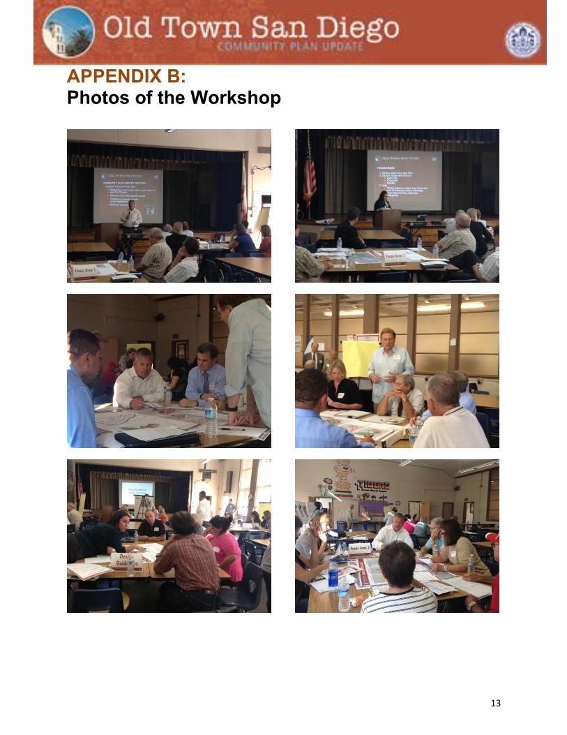
APPENDIX B: Photos of the Workshop

14

15
APPENDIX C: Transcribed Comments
FOCUS AREA 1
First Group
Old Town Transit Center
Transit Center Parking lot is state owned State parks feels parking lot is viable site for structure – state parks should take lead Build 2-3 story parking structure,
o consider retail at ground floor o consider fast food, welcome center
People don’t know Caltrans District 11 Office parking lot is open in evenings/weekends Need for a wayfinding signage program to advertise parking Better signage toward Transit Center parking lot is needed High-speed rail planned to be built over Transit Center parking lot, would still allow for a
parking structure Can you build 3-story structure in Old Town? Any height restrictions?
Land Use
Residential not an appropriate use for this area due to air quality and noise issues Navy has no plans to abandon uses on their property along Pacific Highway Military needs to consider anti-terrorism – don’t like elevated surfaces located above or
adjacent to a facility (i.e., elevated walkway). Any proposed use adjacent to the facility would need to coordinate with military.
Could Perry’s Café site be used for overflow parking?
Second Group
Old Town Transit Center
Transit Center is an intermodal center. . Other uses could be considered but as a minority use to parking. Don’t want other uses (i.e. residential) to crowd transit/parking use
Residential could be a possibility at Transit Center with parking Transit Center parking lot needs to support transit patron parking needs – get as much
parking there as possible. Old Town is a destination location. Parking is for Old Town as well as for a park and
ride facility. Is underground parking possible? Will Mid-coast Trolley extension create greater demand for parking at the Old Town
Transit Center, or will the new line plus operational changes shift demand to other station areas?

16
Land Use
Too much freeway and transportation noise for residential in this area Air quality problems due to proximity to freeway may be too difficult to overcome for
residential to be allowed Navy land: would be willing to move if they were provided equivalent facilities Is there potential to build a parking structure on Navy land? Consider high-rise residential on north parcel between rail and Pac Hwy?
Mobility
At grade rail crossing will cause problems; increased trolley service means gates could be down more than they will be up
Taylor Street thru traffic change, not connect to Morena, bypass Morena One of the goals for the area is to provide parking in this area – Community Plan should
be more specific, not just say that the land use designation is commercial if the goal is to use the land for parking
Need long-term solution to Taylor Street. Opportunity to integrate area north of Taylor? Taylor is supposed to be pedestrian-oriented street. Has become a traffic thoroughfare. Grade crossing at Taylor Street is most significant issue in this area Can you put pedestrian tunnel under tracks? Can you develop tracks north of Taylor as additional platform? Modify through traffic from Rosecrans Street – connect to Morena Blvd. Lower traffic at grade crossing Make sure road is not widened
General Notes:
Birthplace of California at foot of Presidio Hill
Third Group
Mobility
There is a tremendous need for more parking for Old Town Any chance of building a parking lot outside of area with a shuttle in? Publicize availability of parking at Caltrans District 11 office after hours What impact would on-street parking meters have on businesses?
Land Use
What is happening with old Caltrans office building? One of the goals should be to provide more residential land. It is good to link housing to
transit services. Residential could be in great demand in this area if environmental issues could be addressed (air quality, noise)
Commercial development in the area would compete with businesses in Core Sub District
Tour buses need designated loading and unloading area
General Notes
Request for display boards to be posted on website
17
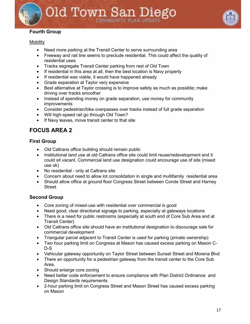
Fourth Group
Mobility
Need more parking at the Transit Center to serve surrounding area Freeway and rail line seems to preclude residential. This could affect the quality of
residential uses. Tracks segregate Transit Center parking from rest of Old Town If residential in this area at all, then the best location is Navy property If residential was viable, it would have happened already Grade separation at Taylor very expensive Best alternative at Taylor crossing is to improve safety as much as possible; make
driving over tracks smoother Instead of spending money on grade separation, use money for community
improvements Consider pedestrian/bike overpasses over tracks instead of full grade separation Will high-speed rail go through Old Town? If Navy leaves, move transit center to that site
FOCUS AREA 2
First Group Old Caltrans office building should remain public Institutional land use at old Caltrans office site could limit reuse/redevelopment and it
could sit vacant. Commercial land use designation could encourage use of site (mixed use ok)
No residential - only at Caltrans site Concern about need to allow lot consolidation in single and multifamily residential area Should allow office at ground floor Congress Street between Conde Street and Harney
Street
Second Group Core zoning of mixed-use with residential over commercial is good Need good, clear directional signage to parking, especially at gateways locations There is a need for public restrooms (especially at south end of Core Sub Area and at
Transit Center) Old Caltrans office site should have an institutional designation to discourage sale for
commercial development Triangular parcel adjacent to Transit Center is used for parking (private ownership) Two hour parking limit on Congress at Mason has caused excess parking on Mason C-
D-S Vehicular gateway opportunity on Taylor Street between Sunset Street and Morena Blvd There an opportunity for a pedestrian gateway from the transit center to the Core Sub
Area. Should enlarge core zoning Need better code enforcement to ensure compliance with Plan District Ordinance and
Design Standards requirements 2-hour parking limit on Congress Street and Mason Street has caused excess parking
on Mason

18
Third Group Land use designation for Old Caltrans office building site should be park Caltrans ROW at tracks and I-8 should also be institutional (public/semi-public). ROW is
just as public/semi-public as other institutional uses. Calhoun Street and Wallace Street adjacent to the State Park should be vacated to the
State Park Concern about development pressure in potential Marston historical district created by
multifamily uses Residential should be allowed on ground floor behind a commercial use (commercial will
fail without street exposure) Retain residential uses Residential uses are more active than office uses Want to preserve residential uses around Congress Street between Conde Street and
Twiggs Street
Fourth Group Old Caltrans Office site would be a good place for parking Parking is main issue May want to consider time limits for on-street parking to encourage turn-over
FOCUS AREA 3
First Group
Fremont School/Ballard Parent Center
Is there any indication that the School District would vacate the School site? (No not at this time)
Has the School District considered a parking structure at the site? (No, the adopted community plan provides recommendations for a future parking facility.)
Larger Parcels in the Hortensia Sub-District
Could a property owner convert an office or hotel use to residential (yes through the permit process)
Smaller Parcels in the Hortensia Sub-District
The mix of residential and small office is good. Could retain residential and still allow for small office uses
Jefferson Sub-District
Should retain residential and keep as residential The community needs more residential uses. Need to preserve character of the area. Should not allow for large single family homes. Could allow for some commercial uses with conditions.
Second Group
Fremont School/Ballard Parent Center
The School District does not have any plans to leave the site. It is still used by the District.
19
In the 20-30 year life of the community plan, the School District could propose changes to the site. The community plan could provide recommendations and guidance should the school district determine the site to be excess or change its function.
Larger Parcels in the Hortensia Sub-District
Should the larger parcels with hotels and offices redevelop, the community plan could provide guidance for how a large parcel could redevelop as to be consistent with the smaller scale in the community.
Smaller Parcels in the Hortensia Sub-District
Does the current plan and zoning limit lot consultation and floor area? (Yes) Could you allow for more floor area? (Yes, but would need to meet parking
requirements) Could you allow for parking in the back of the building? Will the update community plan support new development or place more restrictions? Change should be encouraged. Allow for small office uses and residential Updated plan should focus on making small scale development possible by including
flexibility What is the height limit? There are not many areas in San Diego where a person can build a small office building
for their own office. Could the updated plan allow for parking in front of the building (This may go against
support the pedestrian character of the community). Consider lot consolidations under limited conditions. Can a hotel convert into timeshares? (Potentially)
Jefferson Sub-District
Should not allow for commercial uses in the area.
Third Group
Fremont School/Ballard Parent Center
Would joint use recreational/park use be considered? (Not as likely now that the site does not function with a traditional playground for students.)
The community needs visitor parking for tourist. This would be a good location for parking.
The facility could remain or be rebuilt with additional parking provided as part of a joint use building.
How does the school district use the site? Used for parent and teacher training, leased to a charter school and paid visitor parking.
Could a parking assessment district be established to build and maintain a parking structure such as the structures in downtown?
Could be used for parking and school related use
Larger Parcels in the Hortensia Sub-District
Potential for new mixed use on larger parcels as office and hotel buildings get older. Permit process in Old Town is difficult and lengthy Redevelopment of larger parcels as a single building should still fit the smaller scale
buildings in the community.

20
Certain areas of the community lack internet access and cable and have poor cell phone reception.
Smaller Parcels in the Hortensia Sub-District
Should allow for small office and residential uses or larger buildings with smaller facades to break up the massing.
Old Town Avenue East of Moore Street is a major vehicular gateway. Something is needed to indicate arrival into Old Town
Jefferson Sub-District
Should look at reducing parking requirements for multifamily residential. People walk in the community and can take the trolley
Would mixed use affect residential living above or next to the commercial use? (No if designed correctly)
Fourth Group
Fremont School/Ballard Parent Center
Does Artista Street right-of-way bisect the school property? (The right-of-way is shown as a paper street, but it does not physically bisect the school.)
The community plan should not recommend building a parking facility at the school site due to potential traffic impacts to the local streets. This could affect pedestrian and bicycle safety.
Parking facilities should be on the edges of the community. This site is too close to the center of the core sub area and existing residential areas.
There are not many feasible locations on the southern part of the community. If the visitor parking is located on the northern part of the community, there could be a lot of through traffic from the south on local streets in the community try to get to the northern parking areas.
Should focus on wayfinding signage from the freeway to direct people to the northern parking locations, such as using access Pacific Highway from I-5 or Old Town Avenue to Witherby Street to travel to the northern parking areas.
Should consider converting Jefferson into a one way street and using traffic calming measures.
Should consider using wayfinding signage in the community to direct people to the parking facilities.
Should consider other locations on the edge of the southern part of the community? o Consider the area on San Diego Avenue south of Hortensia Street near the old
Thomas Jefferson Law School building? (This is not within the community) o Consider the area at the intersection of Old Town Avenue and Moore Street?
These could be recommendations where the community would support a parking structure, but it would not need to limit another uses. It could provide it as an option.
Should still recommend supporting educational uses at the school site for charter or private schools.
The freeways uses should be called institutional uses. (Freeways are a transportation use. The community plan will contain recommendations and policies to recommend the use of excess freeway right-of-way should it become available.)

21
Jefferson Sub-District
Should keep as residential Should support the installation of freeway sound barriers.
FOCUS AREA 4: Design Guidelines
First Group
Lot consolidation
General reservations Unique character of the area should be preserved Prevent large scale projects, such as at the south end of the community Forced breaks provide small scale character (referring to axonometric exhibit), should
look like lots of different owners Good example Santa Fe Canyon Road Problem areas outside core; need more attention Big advantage of lot consolidation is it would allow the potential to create underground
parking and community structure might never happen Can help promote historic appearance Could hurt Old Town, but may work for other neighborhoods outside the core (i.e.
Hortensia) An advantage is it would allow potential to create open space Could help promote historic appearance, but need to control appearance Examples… Canyon Road, NM; 6th/Market Quigley project Example Seaport Village (shops within open space area) Idea: 10% surface coverage and rest like shops and parking underground (controversial) There should be a historic exception clause (parking and shops could be underground
i.e. jail) Exceptions on parking ratios and FAR
Subareas
Revise parcel lines to avoid triangular shaped areas, since it is easier to develop rectangles, (referring to property along Linwood.
Second Group Gateways
There used to be big sign at Rosecrans/Pac Hwy The four proposed locations cover all important entries
Streetscape enhancement
Issue parking More directional signs needed i.e. on Old Town Ave/San Diego Ave Need to collaborate with Caltrans regarding unsightly fencing at Moore Street gateway Financing of improvements? Timeline? San Diego Ave: Needs more greenery, such as in a landscaped median

22
Lot consolidation
So far not allowed Need for housing/office use? 5.000 square feet very small for development, maybe set limit higher, i.e. 10,000 square
feet
Setbacks/sidewalks
Too narrow often Planting takes away needed pedestrian space Newspaper stands on sidewalks are an issue Will there be parking meters or designated parking areas?
Subareas
Historic review process
Third Group
Gateways
Locations proposed okay Intersection Ampudia/San Diego Ave/Congress is very difficult. Should consider a
roundabout What about large scale street overarching signs like in Hillcrest and North Park. Are
these appropriate for Old Town? Design would need to fit to historic character
Streetscape enhancement
No focus on Taylor west of tracks necessary Stop at Morena on Taylor Stop at Old Town Ave on San Diego Ave Congress Street: parking reference Focus on pedestrian needs (safety, circulation, accommodation of pedestrian traffic) Theme on San Diego Ave eastern part with palm trees, etc. should be expanded
Lot consolidation
Keep small scale character Number of parcels not limited Current sizes too small for proper development Approval of shown ideas for design guidelines Skeptical towards big corporate merging of too many parcels
Fourth Group
Gateways
Vehicular: o Between Sunset and Morena on Taylor o Ampudia/San Diego Ave/Congress o Old Town Ave/Moore
Old Town Ave/San Diego Ave redundant Pedestrian:
o Transit Station on Congress

23
Big arches o Need to have appropriate design o Signature/branding o Concerns of business people: right balance between commercial and historic
Streetscape enhancement
Keep area smaller Wayfinding treatments should reach farther
Lot consolidation
Would be useful Consider setting limit higher, i.e. 10,000 square feet, not 5,000... and maybe only in
specific areas. Guidelines needed for approval
Gateway Map Comments There is a major pedestrian gateway along Congress Street, just south of the Transit
Center. There is a secondary gateway at the intersection of Congress Street and Twiggs Street. The San Diego Avenue gateway should be drawn west of Old Town Avenue. The
gateway treatment could also be coordinated with mobility and/or urban design improvements to make the Ampudia/San Diego Ave/Congress intersection easier to understand.
The Taylor Street gateway should be drawn south/west of Morena.
Streetscape Map Comments Streetscape improvements should not be shown south of Old Town Avenue. These
could be helpful, but would rather focus in the core. Keeping them north of Old Town Avenue will also help with wayfinding.
Streetscape improvements along Taylor should not be shown west of Tracks, or east of Morena. Would rather place emphasis on Taylor Street between tracks and Morena.
Focus Area 3 Map Comments The area shown as Mixed Commercial –Residential, west of Conde St, should be
Residential only. The area shown as Mixed Commercial –Residential, along Ampudia St, should be small
office and residential.