LAND USE - Bellevue, WA
28
LAND USE CITY OF BELLEVUE COMPREHENSIVE PLAN · LAND USE · PAGE 33 LAND USE LAND USE VISION BELLEVUE GROWS IN A MANNER THAT ENHANCES THE LIVABILITY OF THE COMMUNITY, WHILE MAINTAINING THE ELEMENTS THAT RESIDENTS CHERISH. Growth in Bellevue is focused in denser mixed use centers, like Downtown, BelRed, and Eastgate, while maintaining the city’s outstanding natural environment and the health and vitality of established residenal neighborhoods. WHAT YOU WILL FIND IN THIS CHAPTER f Informaon about the city’s expected populaon and employment growth. f Discussion of challenges and opportunies the city will face as it evolves over the next twenty years. f A map of planned land uses. f Policies about the city’s growth strategy and land uses, as required by the Washington State Growth Management Act.
Transcript of LAND USE - Bellevue, WA

L A N D U S E
CITY OF BELLEVUE COMPREHENSIVE PLAN · LAND USE · PAGE 33
LAND USEL A N D U S E V I S I O N
BELLEVUE GROWS IN A MANNER THAT ENHANCES THE LIVABILITY OF THE COMMUNITY, WHILE MAINTAINING THE ELEMENTS THAT RESIDENTS CHERISH.
Growth in Bellevue is focused in denser mixed use centers, like Downtown, BelRed, and Eastgate, while maintaining the city’s outstanding natural environment and the health and vitality of established residential neighborhoods.
WHAT YOU WILL FIND IN THIS CHAPTER
f Information about the city’s expected population and employment growth.
fDiscussion of challenges and opportunities the city will face as it evolves over the next twenty years.
fA map of planned land uses.
fPolicies about the city’s growth strategy and land uses, as required by the Washington State Growth Management Act.

CITY OF BELLEVUE COMPREHENSIVE PLAN
PAGE 34 · LAND USE · CITY OF BELLEVUE COMPREHENSIVE PLAN
I N T R O D U C T I O N
One of the fundamental roles of the Comprehensive Plan is to
anticipate, guide, and plan for growth in a way that helps the
city achieve its vision. The plan is a tool to look ahead to the
likely growth and ensure that the city’s plans for land uses,
infrastructure, and services are aligned.
The Land Use Element addresses the general pattern of land
use within the city and provides a framework to guide the city’s
overall growth and development. It ensures an appropriate
mix of land uses are available to support the city’s economic
goals, provide services to residents and businesses, and provide
an array of choices for where to live. Land use planning helps
protect environmentally sensitive areas and maintain the
character of established neighborhoods while allowing the city to
evolve to meet the changing needs of the community.

L A N D U S E
CITY OF BELLEVUE COMPREHENSIVE PLAN · LAND USE · PAGE 35
WHAT DOES IT MEAN?
fBy 2035, Bellevue is anticipated to
add 15,800 more housing units and
51,800 more jobs.
fDowntown Bellevue is a regional
center and is expected to
accommodate about half of the
city’s housing and job growth.
fMost of the housing and job growth
outside of Downtown is expected
to occur in BelRed and other mixed
commercial and residential centers.
fThe city’s land use plans seek
to preserve and enhance the
health and vitality of established
neighborhoods and retain natural
areas.
T O D AY ’ S C O N D I T I O N S A N D T O M O R R O W ’ S P R O J E C T I O N S
LAND USE TODAY AND TOMORROW
Today’s Conditions
Bellevue is a major regional job center, with more people working
in the city than living in it. It is the state’s fifth largest city where
about 134,000 people live and 140,000 people work. In the city’s
early years, growth occurred primarily through annexation with the
development of single family subdivisions and community shopping
areas. Now abutting other cities and water bodies, the city no
longer has the ability to grow outward.
Centrally located on the Eastside, Bellevue is served by three
major freeways. Light rail transit connecting the Eastside to Seattle
is planned by 2023. The combination of geographic location,
transportation access, and a beautiful natural setting has drawn
people to live and work in Bellevue.
Bellevue holds on to its legacy as an agrarian community and post-
war suburb with its distinct neighborhoods and beautiful natural
areas and open spaces. In the early 20th century, the natural
environment within Bellevue was changed by the conversion of
upland forest and wetland habitats to agricultural uses and urban
development. Today, the city is home to urban forests, wetlands,
lakes, and more than 50 miles of free-running streams, some of
which are salmon-bearing.
Future growth is largely limited to the redevelopment of existing
areas. Nearly 11.3 million square feet of new commercial and
residential development occurred in Downtown in the last decade,
changing parking lots into high-rise office and residential towers.
Recent planning efforts have identified the areas of BelRed and
Eastgate as opportunities for additional infill redevelopment that
leverages convenient access to transit.

CITY OF BELLEVUE COMPREHENSIVE PLAN
PAGE 36 · LAND USE · CITY OF BELLEVUE COMPREHENSIVE PLAN
Tomorrow’s Projections
Housing and Job Growth Forecasts. The Puget Sound Regional
Council projects the region will grow by more than 1.7 million
people and that the economy will generate more than 1.1 million
additional jobs between 2000 and 2040. Within this regional
context, Bellevue is expected to grow by about 30,200 people and
52,000 jobs by 2035.
Figure LU-1. 2035 Housing, Population and Job Projections
Housing Units
Population Jobs
2012 58,400 130,200 133,4002035 Projection 74,200 160,400 185,100
These local projections are based on state and regional growth
forecasts and the work of cities and counties to identify where
growth should be anticipated. A major underpinning of planning
is the establishment of housing and job “targets” for each city.
King County and its cities use state and regional forecasts to
estimate the housing and non-construction job growth for each
jurisdiction. The targets reflect jurisdictions’ commitment to have
the infrastructure and zoning in place to support growth within
the planning time period. The targets adopted by the Growth
Management Policy Council anticipate housing and job growth for
the 25-year period from 2006 to 2031. To establish a projection for
2035, the city extrapolated trends through 2031, included recently
annexed areas, and adjusted for development that occurred
between 2006 and 2012.

L A N D U S E
CITY OF BELLEVUE COMPREHENSIVE PLAN · LAND USE · PAGE 37
Figure LU-2. 2031 and 2035 Housing and Job Growth
2006 - 2031 Adopted Targets
2012 - 2035 Projected Growth
Housing Units 17,000 15,800Jobs 53,000 51,800
*The Bellevue City Council ratified growth targets for the 2006-2031 period in May 2010 (Resolution 8088).
Bellevue has sufficient land capacity to accommodate about 23,000
additional housing units and about 83,300 jobs, giving it more
than enough capacity to meet is projected growth to 2035. About
half of future housing and job growth is planned for Downtown
Bellevue and the vast majority of the remaining growth is planned
to occur in other mixed use centers, including BelRed, Eastgate and
Wilburton. A small amount of growth is anticipated in other areas
spread throughout the city through natural redevelopment and
infill that is allowed under current zoning.
BUILDABLE LANDS
The 2014 Buildable Lands Report
showed there is a limited supply of
vacant land available for development
in Bellevue, and much of the vacant
land remaining today is constrained
by environmentally sensitive areas,
steep slopes and other factors.
The report showed that the majority
of Bellevue’s capacity for growth
is through redevelopment of
previously developed lands. These
underutilized lands are largely
located in Downtown, BelRed
and other commercial centers.
Zoning and infrastructure supports
redevelopment of these areas to
accommodate the city’s anticipated
growth.

CITY OF BELLEVUE COMPREHENSIVE PLAN
PAGE 38 · LAND USE · CITY OF BELLEVUE COMPREHENSIVE PLAN
Housing Growth 2012-2035
Bellevue is projected to grow from 58,400 housing units in 2012 to 74,200 in 2035. This represents an increase of about 15,800 units over 23 years.
Units 2012
Distribution of Housing Growth
The remainder of the city is projected to grow by 900new units by 2035.
Units 2035
7,300
344 71
7,900
6,000
900
Downtown BelRed/SR 520 Eastgate/ Factoria
Additional housing units in 2035
Housing units in 2012
BelRed/ SR 52038%
Eastgate/ Factoria
6%Remainder
of City6%
Downtown50%
Figure LU-3. Projected Housing Growth

L A N D U S E
CITY OF BELLEVUE COMPREHENSIVE PLAN · LAND USE · PAGE 39
Job Growth 2012-2035
Bellevue is projected to grow from 133,400 jobs in 2012 to about 185,100 in 2035. This represents an increase of 51,800 jobs over 23 years.Note: These figures do not include construction and resource jobs.
Distribution of Job Growth
The remainder of the city is projected to grow by 2,200 new jobs by 2035.
Jobs 2012
Jobs 2035
BelRed/ SR 52025%
Eastgate/ Factoria
16%
Remainder of City
4%
Downtown55%
44,219 33,611
27,322 28,205
28,500
13,000
8,100 2,200
Downtown BelRed/SR 520 Eastgate/ Factoria Remainder of City
Additional jobs in 2035
Jobs in 2012
Figure LU-4. Projected Employment Growth

CITY OF BELLEVUE COMPREHENSIVE PLAN
PAGE 40 · LAND USE · CITY OF BELLEVUE COMPREHENSIVE PLAN
CHALLENGES AND OPPORTUNITIES
Bellevue seeks to meet the challenge of achieving the community’s
land use vision, accommodating future growth, and preserving
what community members love about Bellevue. Challenges and
opportunities include:
� Coordinating Capital Investments with Growth. Residents will continue to expect what Bellevue is known for: excellent services and great parks, schools, and amenities. Without quality services and amenities, people would choose to live and work elsewhere, which could undermine Bellevue’s growth strategy and impact the city’s economic development. Funding the required infrastructure and amenities may be a challenge.
� Aging Commercial Areas. In some older residential areas, neighborhood shopping centers are experiencing high vacancies and struggling to meet changing market conditions. In today’s retail market, more shoppers are choosing regional destinations, larger stores, and online offerings. Smaller shopping centers’ land use mix and urban form may need to be updated to keep them healthy and attracting private investment. In some areas, it may be appropriate to support a wider mix of uses to help fill gaps where there is less demand for traditional retail.
� Integration of Land Use and Transportation. Integrated land use and transportation planning is about choice. Integrating housing and employment with a range of transportation options makes it easier to get around. Having shopping and recreation nearby encourages walking and biking, reducing congestion on the streets and supporting vibrant and healthy communities. Higher densities and a mix of uses encourage walking and transit use. Understanding future land uses also helps the city design and build transportation facilities that continue to work as the city grows.

L A N D U S E
CITY OF BELLEVUE COMPREHENSIVE PLAN · LAND USE · PAGE 41
B E L L E V U E ’ S L A N D U S E P L A N
Land Use Strategy
Bellevue’s land use policies support a clear strategy for managing
growth and development in a manner that is consistent with the
city’s economic strategy, while working to protect and enhance
neighborhoods. Bellevue’s land use strategy will help prepare the
city for expected growth.
The growth strategy for Bellevue:
� Directs most of the city’s growth to Downtown and other areas designated for compact, mixed use development served by a full range of transportation options, such as BelRed and Eastgate.
� Enhances the health and vitality of existing single family and multifamily residential neighborhoods.
� Provides for commercial uses and development that serve community needs.
In addition to being a major commercial center, Downtown is
the city’s fastest growing neighborhood, with opportunities for
creating unique, attractive places. Growth will also occur in BelRed,
transforming it into new neighborhoods with mixtures of residential
and commercial uses served by light rail, as well as the city’s other
centers such as Eastgate, Factoria, and Wilburton. Guiding growth
to Downtown and other mixed use centers supports the city’s
economic objectives and creates new opportunities to live, work,
and play while preserving the qualities of the city’s established
neighborhoods and greenspaces.

CITY OF BELLEVUE COMPREHENSIVE PLAN
PAGE 42 · LAND USE · CITY OF BELLEVUE COMPREHENSIVE PLAN
Growth Management
Adopted in 1990, the state Growth Management Act requires the
state’s fastest growing counties (including King County) and the
cities within them to prepare comprehensive plans. Jurisdictions
planning under the Act are required to plan for twenty years of
growth and must address land use, housing, transportation, and
other planning elements.
Bellevue works towards and provides leadership in ensuring
coordinated and consistent planning in the region, including
participation on regional committees and boards. As a growth
center, Bellevue serves an important role as a major center for jobs,
commerce, transportation, and the arts.
Residential Areas
The city’s residential areas exemplify Bellevue as an area of safe,
quality neighborhoods with strong schools and great parks.
Bellevue’s distinct residential areas have developed over a period
of many decades and range from higher density residential with
apartments and condominiums to mid-density single family
subdivisions to equestrian lots in the northern part of the city.
These diverse neighborhood attributes make Bellevue a unique and
desirable place to live. A major objective of the Land Use Element
is to maintain the vitality, quality, and character of Bellevue’s single
family and multifamily residential neighborhoods while recognizing
that neighborhoods will continue to adapt even while maintaining
their character.
Most neighborhoods are stable, well-maintained, and characterized
by healthy reinvestment. The city’s land use strategies work to
ensure that new infill development appropriately fits into existing
neighborhoods. Some older neighborhoods have not attracted
much private reinvestment. In these cases, the city may encourage
and promote investments in neighborhoods that add vitality
and are compatible with the neighborhood context. Additional

L A N D U S E
CITY OF BELLEVUE COMPREHENSIVE PLAN · LAND USE · PAGE 43
information and policies regarding neighborhoods are in the
Neighborhoods Element.
Neighborhood Commercial Centers
Bellevue has several smaller, neighborhood-oriented retail centers,
such as Northtowne, Lake Hills, and Newport Hills. These centers
not only provide goods and services to local residents, they serve
as important focal points and gathering spaces for the surrounding
communities. Neighborhood centers help establish neighborhood
identity through the unique mix of local stores, design, and even
public art. They are places where people run into their neighbors,
where groups gather for meetings, and where celebrations happen.
Bellevue recognizes the importance of maintaining the health of
these neighborhood centers.
Local neighborhood centers are not expected to grow significantly,
but changes in neighborhood needs and retail demands may
change land use over time. For example, older grocery stores
that are larger than what is competitive in today’s marketplace
may adapt. The city has already seen redevelopment of the Lake
Hills shopping center with a new mix of uses, and some form
of redevelopment is expected at the Newport Hills shopping
center. The Land Use Element supports continued engagement
and investment to maintain the health of these important
neighborhood centers.
Bellevue residents desire places to gather and connect with
neighbors. These places are neither home nor work but an
additional type of gathering place referred to as “third places.” The
Economic Development Element provides further discussion about
the value of revitalizing third places. In some cases, it may also be
appropriate to create new neighborhood gathering places.

CITY OF BELLEVUE COMPREHENSIVE PLAN
PAGE 44 · LAND USE · CITY OF BELLEVUE COMPREHENSIVE PLAN
Downtown and Mixed Use Centers � Downtown. Downtown Bellevue has become the regional
growth center of the Eastside. It is home to regional shopping destinations and tall office buildings as well as historic Main Street. With a large number of new residential developments built since the late 1990s, Downtown is now one of the city’s largest residential neighborhoods. Amenities such as the Meydenbauer Center, the award winning regional library, and a 20-acre urban park add to the vitality of the Downtown Bellevue experience for a growing number of workers and residents.
Downtown has the greatest employment and housing
density in the city. In 2012, there were more than 45,000
jobs in Downtown (representing approximately a quarter
of the city’s employment) and more than 10,000 residents
living Downtown. Together with cultural and entertainment
uses, residents and workers provide an active daytime and
nighttime environment. Local and regional plans designate
Downtown Bellevue as one of King County’s Urban Centers
and the area in Bellevue that will receive the city’s most
intense development. In Vision 2040, the region’s long-term
plan, Downtown Bellevue is one of twenty-eight regional
growth centers and the largest employment center outside
of Seattle. In addition to serving the region, Downtown plays
a vital role for the residents within its boundaries and from
adjacent neighborhoods by providing convenient access to
everyday goods and services.
� BelRed. Historically an area with warehouses and manufacturing, BelRed has begun to transition with the departure of many of the traditional uses, the expansion of the Medical Institution district, and the introduction of more retail shops, auto dealerships, and office developments. The new BelRed Subarea Plan, adopted in 2009, targets significant investments to take advantage of planned light rail stations and an economic niche different from Downtown. The Spring
L A N D U S E
CITY OF BELLEVUE COMPREHENSIVE PLAN · LAND USE · PAGE 45
District development is under construction and aims to be a catalyst around the 120th Avenue station. Overall, BelRed is expected to grow by about 5,000 housing units and 10,000 jobs over the next two decades.
� Eastgate/Factoria. While not home to as many employees as Downtown or the BelRed area, Eastgate/Factoria has a significant concentration of Bellevue’s jobs. The office complexes along the I-90 corridor in the Eastgate/Factoria area are home to many new-economy businesses, including T-Mobile and Verizon. Factoria includes the Market Place at Factoria, a regional retail center, as well retail and services that cater to the surrounding neighborhoods.
� Wilburton. Located along the I-405 corridor, Wilburton has a concentration of offices and hotels, and also includes a significant number of auto dealers and retail stores. This area is anticipated to change significantly due to its strategic location between Downtown and BelRed and its proximity to the freeway and light rail.
� Crossroads. Crossroads, in the northeast quadrant of the city, is a community commercial center containing retail stores and offices that serve both the nearby neighborhoods and the larger community.
Other Commercial Areas
Recognizing the importance of a strong Downtown, city policy is
to foster a strong, diverse economy. To achieve this, it is important
that other commercial districts remain vital. Future economic
conditions and shifting demand may change the nature of some
commercial areas, resulting in redevelopment or new uses in some
business sectors. As the marketplace shifts, the city should plan for
the next generation of uses that will want to locate here.

CITY OF BELLEVUE COMPREHENSIVE PLAN
PAGE 46 · LAND USE · CITY OF BELLEVUE COMPREHENSIVE PLAN
Industrial Areas
Bellevue has a history of light industrial and manufacturing uses.
Over the last decade the demand for light industrial space in
Bellevue has diminished relative to other competing commercial
uses. The city saw significant shifts of light industrial lands with
zoning changes in both Eastgate and the BelRed. Additionally, the
context of manufacturing uses in Bellevue has changed. The BNSF
railroad has ceased operations; Safeway relocated its distribution
and cold storage facility to Auburn; and other, larger industrial
areas have sprung up in other parts of the region, drawing
industrial business away from Bellevue.
It is unlikely that Bellevue will play a regional role in manufacturing
and industrial activity over the next few decades. However,
industrial and commercial properties can have local value, whether
for research and development, construction services, or storage.
The Comprehensive Plan supports maintaining a critical mass of
light industrial lands, primarily in the Richards Valley area, to serve
local needs.
WHAT DOES SUCCESS LOOK LIKE? � Bellevue’s land use pattern creates sufficient land capacity to
achieve growth targets, while directing growth to appropriate areas.
� Neighborhoods have retained their historic character while adapting to current needs.
� New and revitalized mixed use centers are thriving throughout the city.
� Bellevue is a community with “third places” where residents can interact with their neighbors.
PUBLIC HEALTH AND LAND USE
Research has identified how planning
and development can have a major
impact on public health. Development
patterns that promote walking can
significantly reduce health risks
including the growing rates of obesity.

L A N D U S E
CITY OF BELLEVUE COMPREHENSIVE PLAN · LAND USE · PAGE 47
Map LU-1. Generalized Comprehensive Plan Land Use Designations
This map is a generalized view of designated land uses in the Comprehensive Plan showing the geographic and
spatial relationships between different uses. Residential uses are shown as either single-family or multi-family.
Commercial uses are shown as retail, office, medical and light industrial, and all designations allowing mixed use
are shown as one color. See pocket Comprehensive Plan Map or Neighborhood Area (Subarea) plans for detailed
land use designations.
BLVDSE 8TH ST
130T
H A V
NE
132N
D A
V N
E
173R
D AV
E N
E
123R
D AV
SE
KAMBER RO A D
168T
H AV
SE
DRIVE
SE
116T
H A
V S
E
DRIVE
STREET
PARKWAY
100T
H AV
ENU
E N
E
156T
HNE 4TH ST
NE 30TH ST
WAY
118T
H A
V S
E
LAKEMO
NT BLVD SE
SE
SE 36TH ST
NE 8TH ST
AV
112T
H A
V SE
NEWPORT
NEWCASTLE WAY
SE 34TH ST
BELLEVUE14
0TH
AVEN
UE
NE
148T
H A
VEN
UE
NE
SE 22ND ST
W L
AKE
NE BEL-RED ROAD
LAKE WASH. BLVD NE
EASTGATESE
(BEL
LEVU
E W
AY)
NE 12TH ST
116T
H A
V N
E
SE
NE 20TH STREET
HILLS
LAKE
120 T
H A
V NE
124T
H A
V N
E
128T
H
AV
SE
SE 16TH ST
SAM
MAM
ISH
PKW
Y NE
FOREST
160T
H AV
E SE
124T
H A
V SE
HIG HLAN D
VILLAGE PARK DR SE
WAY
NE 40TH ST
NEWCASTLE GOLF CLUB RD
140T
H AV
ENU
E N
E
MAIN 164T
H A
VEN
UE
NE
NORTHUP WAY
134T
H AV
ENU
E N
E
COAL CREEKNE NORTHUP W
AY
SE
WAY
164T
H A
V
S
E
RICH
ARDS
RO
A D
NE 8TH ST
104T
H AV
ENU
E N
E
NEWPORT
123R
D AV
SE
WAY
NE 24TH STREET
SE 24TH ST
119T
H
FACT
ORI
A B
LVD
SELake Hills Connect o r
145TH PL SE
156TH
AVE
NUE
SE
AVEN
UE
NE
132N
D AV
ENU
E N
E
COU
G A R M T WA Y
SE
148T
H AV
ENU
E N
E
MAIN STREET
108T
H AV
ENU
E N
E
112T
H AV
ENU
E N
E
Downtown
BelRed
EastgateFactoria
Crossroads
Wilburton
Data Source:City of Bellevue
Produced by:City of Bellevue Departmentof Planning and CommunityDevelopment andDepartment of InformationTechnology, GIS Division.
Generalized Designations
Single-family
Multi-family
Retail
Office
Medical
Light Industrial
Mixed-Use
Camp and Conference Center
Park or Public Facility Designation
City Limits
Urban Growth Area Boundary
Residential Designations
Commercial Designations
Other Designations

CITY OF BELLEVUE COMPREHENSIVE PLAN
PAGE 48 · LAND USE · CITY OF BELLEVUE COMPREHENSIVE PLAN
Map LU-2. New Neighborhood Area (Subarea) Boundaries
Neighborhood areas define places in Bellevue where planning occurs at a finer level. Plans for neighborhood areas
include specific policies addressing the unique issues of each area. These boundaries are updated to better align
with community expectations. As neighborhood area plans are updated, these new boundaries will be applied.
BLVDSE 8TH ST
130T
H A V
NE
132N
D A
V N
E
173R
D AV
E N
E
123R
D AV
SE
KA MBER RO A D
168T
H AV
SE
DRIVE
SE
116T
H A
V S
E
DRIVE
STREET
PARKWAY
100T
H AV
ENU
E N
E
156T
HNE 4TH ST
NE 30TH ST
WAY
118T
H A
V S
E
LAKEMO
NT BLVD SE
SE
SE 36TH ST
NE 8TH ST
AV
112T
H A
V SE
NEWPORT
NEWCASTLE WAY
SE 34TH ST
BELLEVUE
140T
H AV
ENU
E N
E
148T
H A
VEN
UE
NE
SE 22ND ST
W L
AKE
NE BEL-RED ROAD
LAKE WASH. BLVD NE
EASTGATESE
(BEL
LEVU
E W
AY)
NE 12TH ST
116T
H A
V N
E
SE
NE 20TH STREET
HILLS
LAKE
120 T
H
A V N
E
124T
H A
V N
E
128T
H
AV
SE
SE 16TH STSA
MM
AM
ISH
PKW
Y NE
FOREST
160T
H AV
E SE
124T
H A
V SE
HIG HLAN D
VILLAGE PARK DR SE
WAY
NE 40TH ST
NEWCASTLE GOLF CLUB RD
140T
H AV
ENU
E N
E
MAIN 164T
H A
VEN
UE
NE
NORTHUP WAY
134T
H AV
ENU
E N
E
COAL CREEK
NE NORTHUP WAY
SE
WAY
164T
H A
V
S
E
RICH
ARD
S RO
AD
NE 8TH ST
104T
H AV
ENU
E N
E
NEWPORT
123R
D AV
SE
WAY
NE 24TH STREET
SE 24TH ST
119T
H
FACT
ORI
A B
LVD
SE
Lake Hills Connect o r
145TH PL SE
156TH
AVE
NUE
SE
AVEN
UE
NE
132N
D AV
ENU
E N
E
COUG A R M T WA Y
SE
148T
H AV
ENU
E N
E
MAIN STREET
108T
H AV
ENU
E N
E
112T
H AV
ENU
E N
E
CougarMountain /Lakemont
NorthwestBellevue
WestBellevue
BridleTrails
BelRedBelRed
NortheastBellevue
Crossroads
Wilburton
Woodridge
LakeHills
West LakeSammamish
Newport
Somerset
EastgateFactoria
Downtown
Neighborhood Area (Subarea) Boundaries
Data Source:City of Bellevue
Produced by:City of Bellevue Departmentof Planning and CommunityDevelopment andDepartment of InformationTechnology, GeospatialTechnology Services.

L A N D U S E
CITY OF BELLEVUE COMPREHENSIVE PLAN · LAND USE · PAGE 49
Map LU-3. Community Gathering Places
This map shows different places people can gather within Bellevue to meet and socialize. Places include public
and private venues where people may share a meal or drink such as a coffee shop or restaurant, host a meeting
to work on a project such as a library, school or community center, or go for a walk or recreate such as a park,
trail or recreation center. Generalized land use designations and parks are shown in the background for context.
BLVDSE 8TH ST
130T
H AV
NE
132N
D A
V N
E
173R
D AV
E N
E
123R
D AV
SE
KA MBER RO A D
168T
H AV
SE
DRIVE
SE
116T
H A
V S
E
DRIVE
STREET
PARKWAY
100T
H AV
ENU
E N
E
156T
HNE 4TH ST
NE 30TH ST
WAY
118T
H A
V S
E
LAKEMO
NT BLVD SE
SE
SE 36TH ST
NE 8TH ST
AV
112T
H A
V SE
NEWPORT
NEWCASTLE WAY
SE 34TH ST
BELLEVUE
140T
H AV
ENU
E N
E
148T
H A
VEN
UE
NE
SE 22ND STW
LAK
E
NE BEL-RED ROAD
LAKE WASH. BLVD NE
EASTGATESE
(BEL
LEVU
E W
AY)
NE 12TH ST
116T
H A
V N
E
SE
NE 20TH STREET
HILLS
LAKE
120 T
H
A V N
E
124T
H A
V N
E
128T
H
AV
SE
SE 16TH ST
SAM
MAM
ISH
PKW
Y NE
FOREST
160 T
H AV
E SE
124T
H A
V SE
HIG HLAN D
VILLAGE PARK DR SE
WAY
NE 40TH ST
NEWCASTLE GOLF CLUB RD
140T
H AV
ENU
E N
E
MAIN 164T
H A
VEN
UE
NE
NORTHUP WAY13
4TH
AVEN
UE
NE
COAL CREEK
NE NORTHUP WAY
SE
WAY
164T
H A
V
S
E
RICH
ARDS
RO
AD
NE 8TH ST
104T
H AV
ENU
E N
E
NEWPORT
123R
D AV
SE
WAY
NE 24TH STREET
SE 24TH ST
119T
H
FACT
ORI
A B
LVD
SE
Lake Hills Connect o r
145TH PL SE
156TH
AVE
NU
E S
EAV
ENU
E N
E
132N
D AV
ENU
E N
E
COUG A R M T WA Y
SE
148T
H AV
ENU
E N
EMAIN STREET
108T
H AV
ENU
E N
E
112T
H AV
ENU
E N
E
Gathering Places
Eating and Drinking Places
Religious Organizations
Civic and Social Organizations
Libraries
Country Clubs
Community Centers
Schools
City Parks
Other Parks
City Limits
Data Source:City of Bellevue
Produced by:City of Bellevue Departmentof Planning and CommunityDevelopment andDepartment of InformationTechnology, GeospatialTechnology Services.

CITY OF BELLEVUE COMPREHENSIVE PLAN
PAGE 50 · LAND USE · CITY OF BELLEVUE COMPREHENSIVE PLAN
Map LU-4. Mixed Use Centers
Bellevue has many areas that allow a mix of uses. However, certain mixed use areas are anticipated to
accommodate a significant proportion of the city’s projected growth. These centers allow for different amounts
and types of growth. The three centers traversed by the future light rail extension (Downtown, Wilburton/
Hospital, and BelRed) also encourage transit oriented development (TOD) – mixed use development with strong
connections to transit.
BLVDSE 8TH ST
130T
H AV
NE
132N
D A
V N
E
173R
D AV
E N
E
123R
D AV
SE
KAMBER R O A D
168T
H AV
SE
DRIVE
SE
116T
H A
V S
E
DRIVE
STREET
PARKWAY
100T
H AV
ENU
E N
E
156T
HNE 4TH ST
NE 30TH ST
WAY
118T
H A
V S
E
LAKEMO
NT BLVD SE
SE
SE 36TH ST
NE 8TH ST
AV
112T
H A
V SE
NEWPORT
NEWCASTLE WAY
SE 34TH ST
BELLEVUE14
0TH
AVEN
UE
NE
148T
H A
VEN
UE
NE
SE 22ND ST
W L
AKE
NE BEL-RED ROAD
LAKE WASH. BLVD NE
EASTGATESE
(BEL
LEVU
E W
AY)
NE 12TH ST
116T
H A
V N
E
SE
NE 20TH STREET
HILLS
LAKE
120 T
H A
V N
E
124T
H A
V N
E
128T
H
AV
SE
SE 16TH STSA
MM
AMIS
H P
KWY
NE
FOREST
160 T
H AV
E SE
124T
H A
V SE
HIG HLAN D
VILLAGE PARK DR SE
WAY
NE 40TH ST
NEWCASTLE GOLF CLUB RD
140T
H AV
ENU
E N
E
MAIN 164T
H A
VEN
UE
NE
NORTHUP WAY
134T
H AV
ENU
E N
E
COAL CREEK
NE NORTHUP WAY
SE
WAY
164T
H A
V
S
E
RICH
ARD
S RO
AD
NE 8TH ST
104T
H AV
ENU
E N
E
NEWPORT
123R
D AV
SE
WAY
NE 24TH STREET
SE 24TH ST
119T
H
FACT
ORI
A B
LVD
SELake Hills Connect o r
145TH PL SE
156TH
AVE
NU
E S
EAV
ENU
E N
E
132N
D AV
ENU
E N
E
COU
G A R M T WA Y
SE
148T
H AV
ENU
E N
E
MAIN STREET
108T
H AV
ENU
E N
E
112T
H AV
ENU
E N
E
DowntownCrossroads
Factoria
BelRed
Wilburton/Hospital
Eastgate
Mixed Use Centers
City Limits
Data Source:City of Bellevue
Produced by:City of Bellevue Departmentof Planning and CommunityDevelopment andDepartment of InformationTechnology, GeospatialTechnology Services.
L A N D U S E
CITY OF BELLEVUE COMPREHENSIVE PLAN · LAND USE · PAGE 51
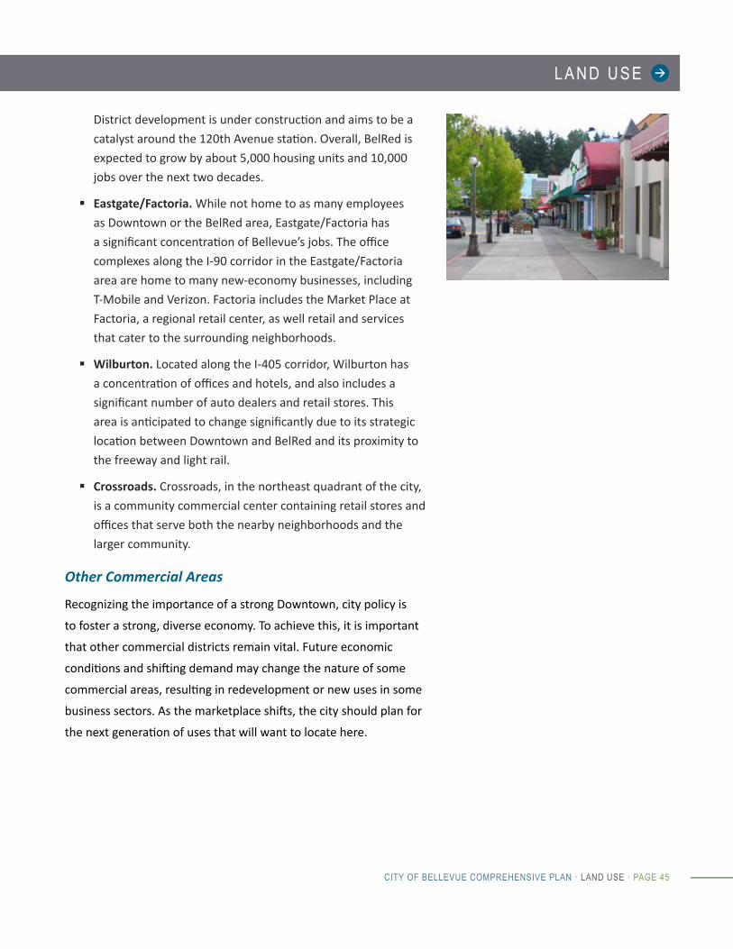
Map LU-5. Elementary School Attendance Areas and Young Children
This map shows the number of young children living within each Elementary School Attendance area. Each dot
represents ten children between the ages of zero and five in 2010 (from the most recent decennial Census),
who would now be elementary school age. The greater the number of dots, the greater the concentration (i.e.
density) of young children living within the attendance area. Schools and attendance areas from the four school
districts serving Bellevue children are represented.
ENATAI
FRANKLIN
CHERRYCREST
WOODRIDGE
STEVENSON
SPIRITRIDGE
HAZELWOOD
EASTGATE
MEDINA
CLYDEHILL
ARDMORE
BENNETT
LAKEHILLS
PHANTOMLAKE
PUESTADEL SOL
SOMERSET
NEWPORTHEIGHTS
SHERWOODFOREST
JING MEI
SUNSET
COUGARRIDGE
RUSH
LAKEVIEW
1 Dot = 10
1 dot = 10 children
Elementary School Attendance Areas
City Limits
Data Sources:U.S. Census Bureau, 2010 Census
Produced by:City of Bellevue Department ofPlanning and CommunityDevelopment and Department ofInformation Technology,Geospatial Technology Services.
Children, 0 to 5 years old in 2010
Note: All elementary schools andattendance areas where Bellevue youthattend are shown. These include schoolswithin the Lake Washington, Bellevue,Renton and Issaquah school districts.

CITY OF BELLEVUE COMPREHENSIVE PLAN
PAGE 52 · LAND USE · CITY OF BELLEVUE COMPREHENSIVE PLAN
Map LU-6. Potential Annexation Areas
Potential Annexation Areas (PAAs) are areas inside the urban growth area boundary that have not yet
incorporated.
BLVDSE 8TH ST
130T
H AV
NE
132N
D A
V N
E
173R
D AV
E N
E
123R
D AV
SE
KA MBER RO A D
168T
H AV
SE
DRIVE
SE
116T
H A
V S
E
DRIVE
STREET
PARKWAY
100T
H AV
ENU
E N
E
156T
HNE 4TH ST
NE 30TH ST
WAY
118T
H A
V S
E
LAKEMO
NT BLVD SE
SE
SE 36TH ST
NE 8TH ST
AV
112T
H A
V SE
NEWPORT
NEWCASTLE WAY
SE 34TH ST
BELLEVUE
140T
H AV
ENU
E N
E
148T
H A
VEN
UE
NE
SE 22ND STW
LAK
E
NE BEL-RED ROAD
LAKE WASH. BLVD NE
EASTGATESE
(BEL
LEVU
E W
AY)
NE 12TH ST
116T
H A
V N
E
SE
NE 20TH STREET
HILLS
LAKE
120 T
H
A V N
E
124T
H A
V N
E
128T
H
AV
SE
SE 16TH ST
SAM
MAM
ISH
PKW
Y NE
FOREST
160 T
H AV
E SE
124T
H A
V SE
HIG HLAN D
VILLAGE PARK DR SE
WAY
NE 40TH ST
NEWCASTLE GOLF CLUB RD
140T
H AV
ENU
E N
E
MAIN 164T
H A
VEN
UE
NE
NORTHUP WAY13
4TH
AVEN
UE
NE
COAL CREEK
NE NORTHUP WAY
SE
WAY
164T
H A
V
S
E
RICH
ARDS
RO
AD
NE 8TH ST
104T
H AV
ENU
E N
E
NEWPORT
123R
D AV
SE
WAY
NE 24TH STREET
SE 24TH ST
119T
H
FACT
ORI
A B
LVD
SE
Lake Hills Connect o r
145TH PL SE
156TH
AVE
NU
E S
EAV
ENU
E N
E
132N
D AV
ENU
E N
E
COUG A R M T WA Y
SE
148T
H AV
ENU
E N
EMAIN STREET
108T
H AV
ENU
E N
E
112T
H AV
ENU
E N
E
Potential Annexation Areas
City Limits
Urban Growth Area Boundary
Data Source:City of Bellevue
Produced by:City of Bellevue Departmentof Planning and CommunityDevelopment andDepartment of InformationTechnology, GeospatialTechnology Services.
L A N D U S E
CITY OF BELLEVUE COMPREHENSIVE PLAN · LAND USE · PAGE 53
G O A L S & P O L I C I E SGOAL
To develop and maintain a land use pattern that protects
natural systems and retains trees and open space; maintains
and strengthens the vitality, quality and character of Bellevue’s
neighborhoods; and focuses development activity in Downtown
and other commercial and residential centers.
POLICIES
Land Use Strategy
LU-1. Promote a clear strategy for focusing the city’s growth and development as follows:
1. Direct most of the city’s growth to the Downtown
regional growth center and to other areas designated
for compact, mixed use development served by a full
range of transportation options.
2. Enhance the health and vitality of existing single
family and multifamily residential neighborhoods.
3. Continue to provide for commercial uses and
development that serve community needs.
LU-2. Retain the city’s park-like character through the preservation and enhancement of parks, open space, and tree canopy throughout the city.
LU-3. Promote a land use pattern and an integrated multimodal transportation system.
GROWTH TARGETS
fBellevue works cooperatively with
King County and other cities to
establish long-range population
growth targets based on state and
regional forecasts.
fThe city’s current adopted growth
targets are for 17,000 additional
housing units and 53,000 additional
jobs for the 2006-2031 period.
This would mean growth of about
15,800 housing units and 51,800
jobs between 2012 and 2035.
fThe city uses these targets to
identify the needed zoning and
infrastructure to accommodate this
level of growth. The targets are not
a commitment that the market will
deliver these numbers.

CITY OF BELLEVUE COMPREHENSIVE PLAN
PAGE 54 · LAND USE · CITY OF BELLEVUE COMPREHENSIVE PLAN
Growth Management
LU-4. Support a land use vision that is consistent with the GMA goals, the regional Vision 2040, and the King County Countywide Planning Policies.
LU-5. Accommodate adopted growth targets of 17,000 additional housing units and 53,000 additional jobs for the 2006-2031 period and plan for the additional growth anticipated by 2035.
LU-6. Encourage new residential development to achieve a substantial portion of the maximum density allowed on the net buildable acreage.
LU-7. Periodically update the city inventory of buildable land capacity and evaluate development activity and achieved densities to ensure that the city is able to meet its regionally-adopted housing and employment targets over the next 20 years.
LU-8. Evaluate household and employment forecasts on a periodic basis to ensure that land use policies based on previous assumptions are current.
LU-9. Work with regional partners to achieve a mix of jobs and housing that makes it possible for people to live closer to where they work.
LU-10. Support school district’s efforts to identify and plan for future school facility siting that meets community needs.
Residential Areas
LU-11. Maintain stability and improve the vitality of residential neighborhoods through adherence to, and enforcement of, the city’s codes.
LU-12. Promote maintenance and establishment of small-scale activity areas within neighborhoods that encourage pedestrian patronage and provide informal opportunities for residents to meet.
LU-13. Support neighborhood efforts to maintain and enhance their character and appearance.

L A N D U S E
CITY OF BELLEVUE COMPREHENSIVE PLAN · LAND USE · PAGE 55
LU-14. Protect residential areas from the impacts of non-residential uses of a scale not appropriate to the neighborhood.
LU-15. Provide, through land use regulation, the potential for a broad range of housing choices to meet the changing needs of the community.
LU-16. Encourage adequate pedestrian connections with nearby neighborhood and transit facilities in all residential site development.
Neighborhood Commercial Centers
LU-17. Maintain areas for shopping centers designed to serve neighborhoods, recognizing their multiple roles: serving residents’ needs, acting as community gathering places, and helping to establish neighborhood identity.
LU-18. Encourage new neighborhood retail and personal services in locations that are compatible with the surrounding neighborhood, allow for ease of pedestrian access, and enhance neighborhood character and identity.
LU-19. Support mixed residential/commercial development in all Neighborhood Business and Community Business land use districts in a manner that is compatible with nearby uses.
Downtown and Mixed Use Centers
LU-20. Support Downtown’s development as a regional growth center, with the density, mix of uses and amenities, and infrastructure that maintain it as the financial, retail, transportation, and business hub of the Eastside.
LU-21. Support development of compact, livable and walkable mixed use centers in BelRed, Eastgate, Factoria, Wilburton and Crossroads.
LU-22. Monitor trends in Bellevue’s job centers and consider land use changes, if needed, to maintain the vitality of these centers.

CITY OF BELLEVUE COMPREHENSIVE PLAN
PAGE 56 · LAND USE · CITY OF BELLEVUE COMPREHENSIVE PLAN
Commercial and Light Industrial Areas Outside of Centers
LU-23. Provide a diversity of commercial areas outside the Downtown to provide an array of business and development opportunities and to serve other parts of the community.
LU-24. Maintain a critical mass of light industrial land in the Richards Valley area and other appropriate areas to serve local needs.
Land Use Compatibility
LU-25. Assess the compatibility of commercial uses and other more intense uses when located in mixed use and predominantly residential areas.
LU-26. Access high-traffic generating land uses from arterials whenever possible. If this is not possible, provide mitigation to address access impacts.
LU-27. Encourage the master planning of multi-building and multi-parcel developments and large institutions to emphasize aesthetics and community compatibility. Include circulation, landscaping, open space, storm drainage, utilities, and building location and design in the master plan.
LU-28. Minimize spillover parking from commercial areas, parks and other facilities encroaching on residential neighborhoods, through residential parking zones and other measures.
Transit Oriented Development Areas
LU-28.1 Provide for a mix of housing, office, service and retail uses in a compact walkable development pattern that optimizes the benefits of transit investment in Bellevue’s transit-oriented development areas.
LU-28.2 Provide walking and bicycle routes in the station area that are accessible, safe and convenient, and that connect to destinations, transit and surrounding bicycle
L A N D U S E
CITY OF BELLEVUE COMPREHENSIVE PLAN · LAND USE · PAGE 57
and pedestrian networks.
LU-28.3 Ensure that transit-oriented land use and development is responsive to the type of transit facilities and services provided and the context of surrounding area.
LU-28.4 Consider a land use incentive system that offers additional floor area in exchange for infrastructure and amenities that contribute to the public good.
Citywide Policies
LU-29. Help communities to maintain their local, distinctive neighborhood character, while recognizing that some neighborhoods may evolve.
LU-30. Recognize the placemaking value of arts and cultural facilities and work to site them throughout the city as a means to enhance neighborhoods.
LU-31. Encourage development of amenities, services and facilities that are supportive of all types of families through investment, incentives and development regulations.
LU-32. Acquire and maintain a system of parks, open space and other landscaped areas to perpetuate Bellevue’s park-like setting and enhance the livability of the city’s neighborhoods.
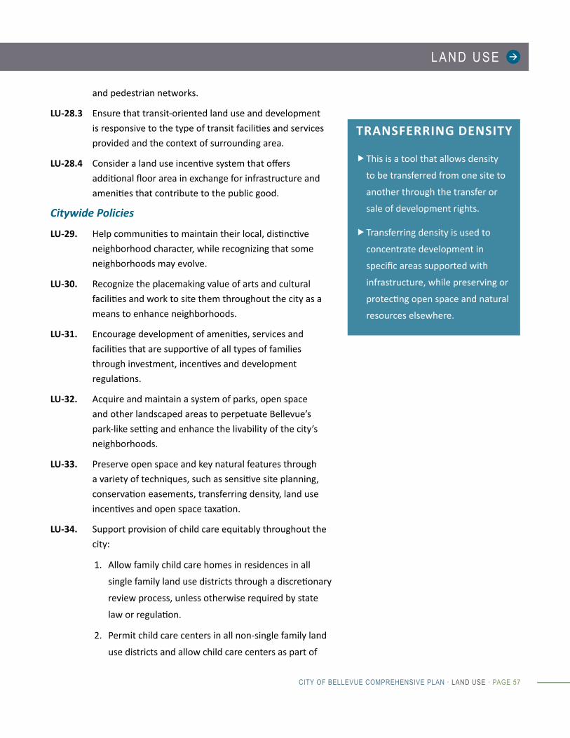
LU-33. Preserve open space and key natural features through a variety of techniques, such as sensitive site planning, conservation easements, transferring density, land use incentives and open space taxation.
LU-34. Support provision of child care equitably throughout the city:
1. Allow family child care homes in residences in all
single family land use districts through a discretionary
review process, unless otherwise required by state
law or regulation.
2. Permit child care centers in all non-single family land
use districts and allow child care centers as part of
TRANSFERRING DENSITY
fThis is a tool that allows density
to be transferred from one site to
another through the transfer or
sale of development rights.
fTransferring density is used to
concentrate development in
specific areas supported with
infrastructure, while preserving or
protecting open space and natural
resources elsewhere.
CITY OF BELLEVUE COMPREHENSIVE PLAN
PAGE 58 · LAND USE · CITY OF BELLEVUE COMPREHENSIVE PLAN
a community facility as long as the center has been
identified as part of any discretionary review permit.
LU-35. Adopt and maintain policies, codes and land use patterns that promote walking in order to increase public health.
LU-36. Locate new community facilities near major transit routes and in areas convenient to pedestrians and bicyclists.
Annexation
LU-37. Support the comprehensive annexation of the city’s remaining Planned Annexation Area.
LU-38. Require owners of land annexing to the city to be subject to their proportionate share of the city’s bonded indebtedness.
LU-39. Make every effort to ensure that land within Bellevue’s Potential Annexation Area develops according to Bellevue Comprehensive Plan policies and development standards.
LU-40. After annexation, transfer all review authority for all land currently undergoing development review in King County to the City of Bellevue.

L A N D U S E
CITY OF BELLEVUE COMPREHENSIVE PLAN · LAND USE · PAGE 59
P O L I C Y C O N N E C T I O N S
The Land Use Element addresses the general location of land uses
in the city and anticipates the amount and distribution of growth.
It provides a framework for other elements, especially planning for
infrastructure and services to respond to growth and changing land
use patterns.
The Housing Element includes policies on ensuring a
sufficient array of housing types and affordability to meet the
community’s needs.
The Capital Facilities and Utilities Elements address the
infrastructure and services needed to serve land uses and
development and also ensure that financial planning for public
improvements is timed consistent with growth expectations.
The Transportation Element is key to understanding the
integration between land use and the city’s multimodal
transportation system to ensure that transportation facilities
and services support the city’s growth strategy.
The Environment and Shoreline Elements address the
protection of natural systems, including critical areas.
The Neighborhoods Element describes the key challenges
and opportunities facing Bellevue’s neighborhoods and
contains policies addressing neighborhood core needs, social
connectivity, adaptability, neighborhood character, and
neighborhood area planning.

CITY OF BELLEVUE COMPREHENSIVE PLAN
PAGE 60 · LAND USE · CITY OF BELLEVUE COMPREHENSIVE PLAN
I M P L E M E N TAT I O N
Bellevue implements the Comprehensive Plan through numerous actions, including day-to-day operations,
capital investments, and review of new development projects. It would be impractical to list every action that
will be taken to implement the plan and impossible to identify actions that may be taken in the future. However,
the programs listed below show some of the next steps that directly relate to the Land Use Element.
Implementation Program TypeLand Use Code Work Program
The Land Use Code work program includes a number of initiatives to update or draft new development regulations.
Land Use Code: updated annually.
Neighborhood Area Plans
Neighborhood area plans are an opportunity to look at planning issues at a neighborhood scale.
Subarea Plans: updated periodically.
Development Review
Review of development projects works to ensure that they conform with the Land Use Code.
Program: on-going.