Land Use and Development Opportunities Report -...
42
Land Use and Development Opportunities Report August 2010 WESTSIDE SUBWAY EXTENSION
Transcript of Land Use and Development Opportunities Report -...

Land Use and Development Opportunities Report
August 2010
WESTSIDE SUBWAY EXTENSION


Final Land Use and Development Opportunities Report
Table of Contents
W E S T S I D E S U B W A Y E X T E N S I O N August 16, 2010 Page i
Table of Contents 1.0 INTRODUCTION............................................................................................................................. 1-1
2.0 PROJECT DESCRIPTION ............................................................................................................... 2-1 2.1 No Build Alternative ............................................................................................................... 2-1 2.2 TSM Alternative ...................................................................................................................... 2-1 2.3 Build Alternatives ................................................................................................................... 2-1
2.3.1 Alternative 1—Westwood/UCLA Extension ............................................................ 2-2 2.3.2 Alternative 2—Westwood/Veterans Administration (VA) Hospital
Extension .................................................................................................................... 2-2 2.3.3 Alternative 3—Santa Monica Extension ................................................................... 2-2 2.3.4 Alternative 4—Westwood/VA Hospital Extension plus West Hollywood
Extension .................................................................................................................... 2-4 2.3.5 Alternative 5—Santa Monica Extension plus West Hollywood Extension ............ 2-4
2.4 Stations and Segment Options .............................................................................................. 2-6 2.4.1 Option 1—Wilshire/Crenshaw Station Option ....................................................... 2-9 2.4.2 Option 2—Wilshire/Fairfax Station East Option ..................................................... 2-9 2.4.3 Option 3—Wilshire/La Cienega Station Option .................................................... 2-10 2.4.4 Option 4—Century City Station and Segment Options ........................................ 2-10 2.4.5 Option 5—Westwood/UCLA Station Options ....................................................... 2-11 2.4.6 Option 6—Westwood/VA Hospital Station Option .............................................. 2-12
2.5 Base Stations ......................................................................................................................... 2-12 2.6 Other Components of the Build Alternatives ..................................................................... 2-13
2.6.1 Traction Power Substations .................................................................................... 2-13 2.6.2 Emergency Generators ............................................................................................ 2-13 2.6.3 Mid-Tunnel Vent Shaft ............................................................................................ 2-13 2.6.4 Trackwork Options .................................................................................................. 2-14 2.6.5 Rail Operations Center ............................................................................................ 2-16 2.6.6 Maintenance Yards .................................................................................................. 2-16
2.7 Minimum Operable Segments ............................................................................................ 2-17 2.7.1 MOS 1—Fairfax Extension ...................................................................................... 2-17 2.7.2 MOS 2—Century City Extension ............................................................................ 2-17
3.0 REGULATORY FRAMEWORK ....................................................................................................... 3-1 3.1 Regional ................................................................................................................................... 3-1 3.2 Local ......................................................................................................................................... 3-1
3.2.1 City of Los Angeles, Land Use/Transportation Policy ............................................. 3-2 3.2.2 City of Los Angeles, Residential/Accessory Services Zones and Density
Bonus Ordinance ....................................................................................................... 3-3 3.2.3 City of Los Angeles, Citywide General Plan Framework ........................................ 3-3 3.2.4 City of Los Angeles General Plan’s Transportation Element .................................. 3-5 3.2.5 City of Los Angeles General Plan’s Land Use Element ........................................... 3-5 3.2.6 Brentwood-Palisades Community Plan .................................................................... 3-6 3.2.7 Westwood Community Plan ..................................................................................... 3-6 3.2.8 West Los Angeles Community Plan ......................................................................... 3-6 3.2.9 Hollywood Community Plan .................................................................................... 3-6 3.2.10 Wilshire Community Plan ........................................................................................ 3-7 3.2.11 Specific Plans ............................................................................................................. 3-7

Final Land Use and Development Opportunities Report
Table of Contents
W E S T S I D E S U B W A Y E X T E N S I O N August 16, 2010 Page ii
3.2.12 Park Mile Specific Plan .............................................................................................. 3-7 3.2.13 West Los Angeles Transportation Improvement and Mitigation Specific
Plan ............................................................................................................................. 3-7 3.2.14 Wilshire-Westwood Scenic Corridor Specific Plan .................................................. 3-7 3.2.15 Century City North Specific Plan .............................................................................. 3-8 3.2.16 Westside Cities Multimodal Mobility Study ............................................................. 3-8 3.2.17 Redevelopment Plans ................................................................................................ 3-9 3.2.18 CRA/LA Hollywood Redevelopment Project ........................................................... 3-9 3.2.19 CRA/LA Mid-City Recovery Redevelopment Project ............................................... 3-9 3.2.20 CRA/LA Wilshire Center-Koreatown Redevelopment Project ................................ 3-9 3.2.21 City of West Hollywood, General Plan ................................................................... 3-10 3.2.22 City of Beverly Hills, General Plan ......................................................................... 3-10 3.2.23 City of Santa Monica, General Plan. ....................................................................... 3-11 3.2.24 County of Los Angeles, General Plan ..................................................................... 3-12 3.2.25 Existing County of Los Angeles General Plan ........................................................ 3-12 3.2.26 Draft County of Los Angeles General Plan Update 2008 ...................................... 3-13 3.2.27 Transit Oriented District Ordinance ....................................................................... 3-13
4.0 AFFECTED ENVIRONMENT .......................................................................................................... 4-1 4.1 Existing Land Uses .................................................................................................................. 4-1 4.2 Existing Land Uses – Station Areas ....................................................................................... 4-1
5.0 ENVIRONMENTAL IMPACT/ENVIRONMENTAL CONSEQUENCES ..................................... 5-1 5.1 Methodology ............................................................................................................................ 5-1 5.2 No Build Alternative ............................................................................................................... 5-2
5.2.1 Regional Land Use and Development ...................................................................... 5-2 5.2.2 Local Land Use and Development ............................................................................ 5-2
5.3 Transportation System Management Alternative ................................................................. 5-3 5.3.1 Regional Land Use and Development ...................................................................... 5-3 5.3.2 Local Land Use and Development ............................................................................ 5-4
5.4 Alternative 1—Westwood/UCLA Extension ......................................................................... 5-4 5.4.1 Regional Land Use and Development ...................................................................... 5-5 5.4.2 Local Land Use and Development ............................................................................ 5-2 5.4.3 Adjacent or Surrounding Land Uses ........................................................................ 5-3 5.4.4 Mitigation Measures ................................................................................................ 5-17
5.5 Alternative 2—Westwood/VA Hospital Extension ............................................................. 5-17 5.5.1 Regional Land Use and Development .................................................................... 5-18 5.5.2 Local Land Use and Development .......................................................................... 5-18 5.5.3 Adjacent or Surrounding Land Uses ...................................................................... 5-19 5.5.4 Mitigation Measures ................................................................................................ 5-19
5.6 Alternative 3—Santa Monica Extension .............................................................................. 5-19 5.6.1 Regional Land Use and Development .................................................................... 5-22 5.6.2 Local Land Use and Development .......................................................................... 5-22 5.6.3 Adjacent or Surrounding Land Uses ...................................................................... 5-23 5.6.4 Mitigation Measures ................................................................................................ 5-23
5.7 Alternative 4—Westwood/VA Hospital Extension Plus West Hollywood Extension ....... 5-29 5.7.1 Regional Land Use and Development .................................................................... 5-29 5.7.2 Local Land Use and Development .......................................................................... 5-30 5.7.3 Adjacent or Surrounding Land Uses ...................................................................... 5-30 5.7.4 Mitigation Measures ................................................................................................ 5-31

Final Land Use and Development Opportunities Report
Table of Contents
W E S T S I D E S U B W A Y E X T E N S I O N August 16, 2010 Page iii
5.8 Alternative 5—Santa Monica Extension Plus West Hollywood Extension ....................... 5-37 5.8.1 Regional Land Use and Development .................................................................... 5-37 5.8.2 Local Land Use and Development .......................................................................... 5-37 5.8.3 Adjacent or Surrounding Land Uses ...................................................................... 5-38 5.8.4 Mitigation Measures ................................................................................................ 5-38
5.9 MOS-1—Fairfax Station Terminus ...................................................................................... 5-38 5.9.1 Regional Land Use and Development .................................................................... 5-38 5.9.2 Local Land Use and Development .......................................................................... 5-38 5.9.3 Mitigation Measures ................................................................................................ 5-39
5.10 MOS-2—Century City Station Terminus ............................................................................ 5-39 5.10.1 Regional Land Use and Development .................................................................... 5-39 5.10.2 Local Land Use and Development .......................................................................... 5-39 5.10.3 Mitigation Measures ................................................................................................ 5-39
5.11 Build Options 1-5 .................................................................................................................. 5-39 5.11.1 Regional Land Use and Development .................................................................... 5-39 5.11.2 Local Land Use and Development .......................................................................... 5-40 5.11.3 Mitigation Measures ................................................................................................ 5-41
6.0 CEQA DETERMINATION ............................................................................................................... 6-1
List of Figures
Figure 2-1. Alternative 1—Westwood/UCLA Extension ............................................................................. 2-3
Figure 2-2. Alternative 2—Westwood/Veterans Administration (VA) Hospital Extension ...................... 2-3
Figure 2-3. Alternative 3—Santa Monica Extension.................................................................................... 2-4
Figure 2-4. Alternative 4—Westwood/VA Hospital Extension plus West Hollywood Extension ............ 2-5
Figure 2-5. Alternative 5—Santa Monica Extension plus West Hollywood Extension ............................. 2-5
Figure 2-6. Station and Alignment Options ................................................................................................. 2-8
Figure 2-7. Option 1—No Wilshire/Crenshaw Station Option .................................................................. 2-9
Figure 2-8. Option 2—Fairfax Station Option ............................................................................................. 2-9
Figure 2-9. Option 3—La Cienega Station Option .................................................................................... 2-10
Figure 2-10. Century City Station Options ................................................................................................. 2-11
Figure 2-11. Option 5—Westwood/UCLA Station Options ...................................................................... 2-12
Figure 2-12. Option 6—Westwood/VA Hospital Station North ............................................................... 2-12
Figure 2-13. Location of the Rail Operations Center and Maintenance Yards ........................................ 2-16
Figure 2-14. UP Railroad Rail Bridge ......................................................................................................... 2-17
Figure 2-15. Maintenance Yard Options .................................................................................................... 2-17
Figure 3-1. Jurisdictions and City of Los Angeles Neighborhoods ............................................................. 3-2
Figure 5-1. Wilshire/Crenshaw 1/4-Mile Station Area ............................................................................... 5-9
Figure 5-2. Wilshire/La Brea 1/4-Mile Station Area .................................................................................. 5-10
Figure 5-3. Wilshire/Fairfax 1/4-Mile Station Area ................................................................................... 5-11
Figure 5-4. Wilshire/La Cienega 1/4-Mile Station Area ............................................................................ 5-12

Final Land Use and Development Opportunities Report
Table of Contents
W E S T S I D E S U B W A Y E X T E N S I O N August 16, 2010 Page iv
Figure 5-5. Wilshire/Rodeo 1/4-Mile Station Area .................................................................................... 5-13
Figure 5-6. Century City 1/4-Mile Station Area ......................................................................................... 5-14
Figure 5-7. Wilshire/Westwood 1/4-Mile Station Area ............................................................................. 5-15
Figure 5-8. Wilshire/VA Hospital 1/4-Mile Station Area .......................................................................... 5-21
Figure 5-9. Wilshire/Bundy 1/4-Mile Station Area.................................................................................... 5-25
Figure 5-10. Wilshire/26th 1/4-Mile Station Area ..................................................................................... 5-26
Figure 5-11. Wilshire/16th 1/4-Mile Station Area ..................................................................................... 5-27
Figure 5-12. Wilshire/4th 1/4-Mile Station Area ....................................................................................... 5-28
Figure 5-13. Hollywood Highland 1/4-Mile Station Area ......................................................................... 5-32
Figure 5-14. Santa Monica/La Brea 1/4-Mile Station Area ....................................................................... 5-33
Figure 5-15. Santa Monica/Fairfax 1/4-Mile Station Area ........................................................................ 5-34
Figure 5-16. Santa Monica/San Vicente 1/4-Mile Station Area ................................................................ 5-35
Figure 5-17. Beverly Center 1/4-Mile Station Area .................................................................................... 5-36
List of Tables
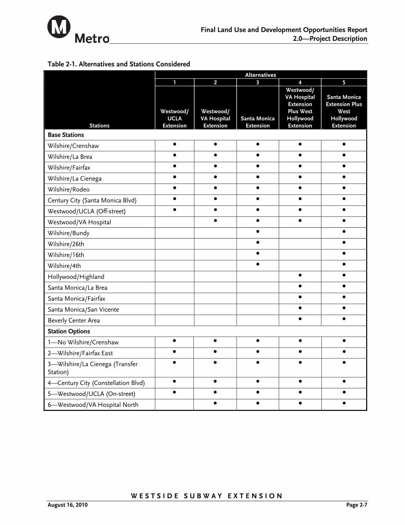
Table 2-1. Alternatives and Stations Considered ......................................................................................... 2-7
Table 2-2. Mid-Tunnel Vent Shaft Locations ............................................................................................. 2-14
Table 2-3. Special Trackwork Locations ...................................................................................................... 2-15
Table 4-1. Land Use Distribution within the Study Area ............................................................................ 4-1
Table 4-2. Existing Land Uses at Potential Station Locations ..................................................................... 4-2
Table 5-1. Comparison of the Proposed Project (Alternatives 1–5) to SCAG Regional Policies (Regional Comprehensive Plan) ......................................................................................... 5-5
Table 5-2. Goals and Policy Consistency for Alternative 1 .......................................................................... 5-4
Table 5-3. Additional Goals and Policy Consistency for Alternative 2 ...................................................... 5-20
Table 5-4. Additional Goals and Policy Consistency for Alternative 3 ...................................................... 5-24
Table 5-5. Additional Goals and Policy Consistency for Alternative 4 ...................................................... 5-31

Final Land Use and Development Opportunities Report
Acronyms and Abbreviations
W E S T S I D E S U B W A Y E X T E N S I O N August 16, 2010 Page v
Acronyms and Abbreviations AA Alternatives Analysis
ADA Americans with Disabilities Act (42 USC 126)
APM automated people mover
BRS blast relief shafts
BRT bus rapid transit
CATGP cumulative automobile trip generation potential
CCNSP Century City North Specific Plan
CCTV closed-circuit television
CEQA California Environmental Quality Act (PRC 21000-21177)
CSOP control standard operating procedure
EIR environmental impact report
EIS environmental impact statement
Expo I Exposition Boulevard Light Rail Phase I
Expo II Exposition Boulevard Light Rail Phase II
FAI fresh air intakes
Framework Citywide General Plan Framework
GLAVA Greater Los Angeles Veterans Administration
HOV high-occupancy vehicle
HRT heavy rail transit
HRV heavy rail vehicles
I-10 Interstate 10 Freeway
I-405 Interstate 405 Freeway
LADOT Los Angeles Department of Transportation
LACTC Los Angeles County Transportation Commission
LAWA Los Angeles World Airports
LAX Los Angeles Airport
LPA Locally Preferred Alternative
LRT light rail transit
LRTP Long Range Transportation Plan
Metro Los Angeles County Metropolitan Transportation Authority
MOS minimum operable segments
mph miles per hour

Final Land Use and Development Opportunities Report
Acronyms and Abbreviations
W E S T S I D E S U B W A Y E X T E N S I O N August 16, 2010 Page vi
MPO Metropolitan Planning Organization
NEPA National Environmental Policy Act (42 USC 4321-4347)
OTE over track exhaust
RAS Residential/Accessory Services
RCPG Regional Comprehensive Plan and Guide
RTP Regional Transportation Plan
SCAG Southern California Association of Governments
SCRTD Southern California Regional Transit District
SOP standard operating procedure
SR 90 State Route 90
TDM transportation demand management
TPIS transit passenger information system
TPSS traction power substation
TSM transportation system management
TVM ticket vending machines
UPE under platform exhaust
UPRR Union Pacific Railroad
VA Veterans Administration
VMT vehicle miles traveled
WTOD Wilshire Boulevard transit oriented development

Final Land Use and Development Opportunities Report
1.0—Introduction
W E S T S I D E S U B W A Y E X T E N S I O N August 16, 2010 Page 1-1
1.0 INTRODUCTION
This report examines the affected environment and potential impacts of the Project related to land use and development. Following a description of the proposed project is a discussion on the regulatory framework and the adopted plans and policies of the existing communities and jurisdictions that may be affected by the proposed Project alternatives. Lastly, the impacts of each project alternative and the design options are discussed. If applicable, mitigation measures are identified to reduce potential significant impacts.
Major transit projects can result in changes to the layout of the area, demographics, and land uses of local communities. As new development results in changes to land use patterns, the character of an area can be affected and adverse physical effects to the environment may potentially occur. As part of the National Environmental Policy Act (NEPA) process, the Metro has coordinated with local planning agencies and conducted public outreach to determine the scope of potential effects the proposed alternatives may have on land use and development within the corridor study area.


Final Land Use and Development Opportunities Report
2.0—Project Description
W E S T S I D E S U B W A Y E X T E N S I O N August 16, 2010 Page 2-1
2.0 PROJECT DESCRIPTION
This chapter describes the alternatives that have been considered to best satisfy the Purpose and Need and have been carried forward for further study in the Draft Environmental Impact Statement/Environmental Impact Report (EIS/EIR). Details of the No Build, Transportation Systems Management (TSM), and the five Build Alternatives (including their station and alignment options and phasing options (or minimum operable segments [MOS]) are presented in this chapter.
2.1 No Build Alternative
The No Build Alternative provides a comparison of what future conditions would be like if the Project were not built. The No Build Alternative includes all existing highway and transit services and facilities, and the committed highway and transit projects in the Metro LRTP and the SCAG RTP. Under the No Build Alternative, no new transportation infrastructure would be built within the Study Area, aside from projects currently under construction or projects funded for construction, environmentally cleared, planned to be in operation by 2035, and identified in the adopted Metro LRTP.
2.2 TSM Alternative
The TSM Alternative emphasizes more frequent bus service than the No Build Alternative to reduce delay and enhance mobility. The TSM Alternative contains all elements of the highway, transit, Metro Rail, and bus service described under the No Build Alternative. In addition, the TSM Alternative increases the frequency of service for Metro Bus Line 720 (Santa Monica–Commerce via Wilshire Boulevard and Whittier Boulevard) to between three and four minutes during the peak period.
In the TSM Alternative, Metro Purple Line rail service to the Wilshire/Western Station would operate in each direction at 10-minute headways during peak and off-peak periods. The Metro Red Line service to Hollywood/Highland Station would operate in each direction at five-minute headways during peak periods and at 10-minute headways during midday and off-peak periods.
2.3 Build Alternatives
The Build Alternatives are considered to be the “base” alternatives with “base” stations. Alignment (or segment) and station options were developed in response to public comment, design refinement, and to avoid and minimize impacts to the environment.
The Build Alternatives extend heavy rail transit (HRT) service in subway from the existing Metro Purple Line Wilshire/Western Station. HRT systems provide high speed (maximum of 70 mph), high capacity (high passenger-carrying capacity of up to 1,000 passengers per train and multiple unit trains with up to six cars per train), and reliable service since they operate in an exclusive grade-separated right-of-way. The subway will operate in a tunnel at least 30 to 70 feet below ground and will be electric powered.
Furthermore, the Build Alternatives include changes to the future bus services. Metro Bus Line 920 would be eliminated and a portion of Line 20 in the City of Santa Monica would be eliminated since it would be duplicated by the Santa Monica Blue Bus Line 2. Metro Rapid

Final Land Use and Development Opportunities Report
2.0—Project Description
W E S T S I D E S U B W A Y E X T E N S I O N August 16, 2010 Page 2-2
Bus Line 720 would operate less frequently since its service route would be largely dupli-cated by the Westside Subway route. In the City of Los Angeles, headways (time between buses) for Line 720 are between 3 and 5 minutes under the existing network and will be between 5 and 11.5 minutes under the Build Alternatives, but no change in Line 720 would occur in the City of Santa Monica segment. Service frequencies on other Metro Rail lines and bus routes in the corridor would be the same as for the No Build Alternative.
2.3.1 Alternative 1—Westwood/UCLA Extension
This alternative extends the existing Metro Purple Line from the Wilshire/Western Station to a Westwood/UCLA Station (Figure 2-1). From the Wilshire/Western Station, Alternative 1 travels westerly beneath Wilshire Boulevard to the Wilshire/Rodeo Station and then southwesterly toward a Century City Station. Alternative 1 then extends from Century City and terminates at a Westwood/UCLA Station. The alignment is approximately 8.60 miles in length.
Alternative 1 would operate in each direction at 3.3-minute headways during morning and evening peak periods and at 10-minute headways during midday. The estimated one-way running time is 12 minutes 39 seconds from the Wilshire/Western Station.
2.3.2 Alternative 2—Westwood/Veterans Administration (VA) Hospital Extension
This alternative extends the existing Metro Purple Line from the Wilshire/Western Station to a Westwood/VA Hospital Station (Figure 2-2). Similar to Alternative 1, Alternative 2 extends the subway from the Wilshire/Western Station to a Westwood/UCLA Station. Alternative 2 then travels westerly under Veteran Avenue and continues west under the I-405 Freeway, terminating at a Westwood/VA Hospital Station. This alignment is 8.96 miles in length from the Wilshire/Western Station.
Alternative 2 would operate in each direction at 3.3-minute headways during the morning and evening peak periods and at 10-minute headways during the midday, off-peak period. The estimated one-way running time is 13 minutes 53 seconds from the Wilshire/Western Station.
2.3.3 Alternative 3—Santa Monica Extension
This alternative extends the existing Metro Purple Line from the Wilshire/Western Station to the Wilshire/4th Station in Santa Monica (Figure 2-3). Similar to Alternative 2, Alternative 3 extends the subway from the Wilshire/Western Station to a Westwood/VA Hospital Station. Alternative 3 then continues westerly under Wilshire Boulevard and terminates at the Wilshire/4th Street Station between 4th and 5th Streets in Santa Monica. The alignment is 12.38 miles.
Alternative 3 would operate in each direction at 3.3-minute headways during the morning and evening peak periods and operate with 10-minute headways during the midday, off-peak period. The estimated one-way running time is 19 minutes 27 seconds from the Wilshire/Western Station.

Final Land Use and Development Opportunities Report
2.0—Project Description
W E S T S I D E S U B W A Y E X T E N S I O N August 16, 2010 Page 2-3
Figure 2-1. Alternative 1—Westwood/UCLA Extension
Figure 2-2. Alternative 2—Westwood/Veterans Administration (VA) Hospital Extension

Final Land Use and Development Opportunities Report
2.0—Project Description
W E S T S I D E S U B W A Y E X T E N S I O N August 16, 2010 Page 2-4
Figure 2-3. Alternative 3—Santa Monica Extension
2.3.4 Alternative 4—Westwood/VA Hospital Extension plus West Hollywood Extension
Similar to Alternative 2, Alternative 4 extends the existing Metro Purple Line from the Wilshire/Western Station to a Westwood/VA Hospital Station. Alternative 4 also includes a West Hollywood Extension that connects the existing Metro Red Line Hollywood/Highland Station to a track connection structure near Robertson and Wilshire Boulevards, west of the Wilshire/La Cienega Station (Figure 2-4). The alignment is 14.06 miles long.
Alternative 4 would operate from Wilshire/Western to a Westwood/VA Hospital Station in each direction at 3.3-minute headways during morning and evening peak periods and 10-minute headways during the midday off-peak period. The West Hollywood extension would operate at 5-minute headways during peak periods and 10-minute headways during the midday, off-peak period. The estimated one-way running time for the Metro Purple Line extension is 13 minutes 53 seconds, and the running time for the West Hollywood from Hollywood/Highland to Westwood/VA Hospital is 17 minutes and 2 seconds.
2.3.5 Alternative 5—Santa Monica Extension plus West Hollywood Extension
Similar to Alternative 3, Alternative 5 extends the existing Metro Purple Line from the Wilshire/Western Station to the Wilshire/4th Station and also adds a West Hollywood Extension similar to the extension described in Alternative 4 (Figure 2-5). The alignment is 17.49 miles in length. Alternative 5 would operate the Metro Purple Line extension in each direction at 3.3-minute headways during the morning and evening peak periods and 10-minute headways during the midday, off-peak period. The West Hollywood extension would operate in each direction at 5-minute headways during peak periods and 10-minute headways during the midday, off-peak period. The estimated one-way running time for the

Final Land Use and Development Opportunities Report
2.0—Project Description
W E S T S I D E S U B W A Y E X T E N S I O N August 16, 2010 Page 2-5
Metro Purple Line extension is 19 minutes 27 seconds, and the running time from the Hollywood/Highland Station to the Wilshire/4th Station is 22 minutes 36 seconds.
Figure 2-4. Alternative 4—Westwood/VA Hospital Extension plus West Hollywood Extension
Figure 2-5. Alternative 5—Santa Monica Extension plus West Hollywood Extension

Final Land Use and Development Opportunities Report
2.0—Project Description
W E S T S I D E S U B W A Y E X T E N S I O N August 16, 2010 Page 2-6
2.4 Stations and Segment Options
HRT stations consist of a station “box,” or area in which the basic components are located. The station box can be accessed from street-level entrances by stairs, escalators, and elevators that would bring patrons to a mezzanine level where the ticketing functions are located. The 450-foot platforms are one level below the mezzanine level and allow level boarding (i.e., the train car floor is at the same level as the platform). Stations consist of a center or side platform. Each station is equipped with under-platform exhaust shafts, over-track exhaust shafts, blast relief shafts, and fresh air intakes. In most stations, it is anticipated that only one portal would be constructed as part of the Project, but additional portals could be developed as a part of station area development (by others). Stations and station entrances would comply with the Americans with Disabilities Act of 1990, Title 24 of the California Code of Regulations, the California Building Code, and the Department of Transportation Subpart C of Section 49 CFR Part 37.
Platforms would be well-lighted and include seating, trash receptacles, artwork, signage, safety and security equipment (closed-circuit television, public announcement system, passenger assistance telephones), and a transit passenger information system. The fare collection area includes ticket vending machines, fare gates, and map cases.
Table 2-1 lists the stations and station options evaluated and the alternatives to which they are applicable. Figure 2-6 shows the proposed station and alignment options. These include:
Option 1—Wilshire/Crenshaw Station Option
Option 2—Fairfax Station Option
Option 3—La Cienega Station Option
Option 4—Century City Station and Alignment Options
Option 5—Westwood/UCLA Station Option
Option 6—Westwood/VA Hospital Station Option
Final Land Use and Development Opportunities Report
2.0—Project Description
W E S T S I D E S U B W A Y E X T E N S I O N August 16, 2010 Page 2-7
Table 2-1. Alternatives and Stations Considered
Stations
Alternatives 1 2 3 4 5
Westwood/ UCLA
Extension
Westwood/ VA Hospital Extension
Santa Monica Extension
Westwood/ VA Hospital Extension Plus West Hollywood Extension
Santa Monica Extension Plus
West Hollywood Extension
Base Stations
Wilshire/Crenshaw ● ● ● ● ●
Wilshire/La Brea ● ● ● ● ●
Wilshire/Fairfax ● ● ● ● ●
Wilshire/La Cienega ● ● ● ● ●
Wilshire/Rodeo ● ● ● ● ●
Century City (Santa Monica Blvd) ● ● ● ● ●
Westwood/UCLA (Off-street) ● ● ● ● ●
Westwood/VA Hospital ● ● ● ●
Wilshire/Bundy ● ●
Wilshire/26th ● ●
Wilshire/16th ● ●
Wilshire/4th ● ●
Hollywood/Highland ● ●
Santa Monica/La Brea ● ●
Santa Monica/Fairfax ● ●
Santa Monica/San Vicente ● ●
Beverly Center Area ● ●
Station Options
1—No Wilshire/Crenshaw ● ● ● ● ●
2—Wilshire/Fairfax East ● ● ● ● ●
3—Wilshire/La Cienega (Transfer Station)
● ● ● ● ●
4—Century City (Constellation Blvd) ● ● ● ● ●
5—Westwood/UCLA (On-street) ● ● ● ● ●
6—Westwood/VA Hospital North ● ● ● ●

Final Land Use and Development Opportunities Report
2.0—Project Description
W E S T S I D E S U B W A Y E X T E N S I O N August 16, 2010 Page 2-8
Figure 2-6. Station and Alignment Options

Final Land Use and Development Opportunities Report
2.0—Project Description
W E S T S I D E S U B W A Y E X T E N S I O N August 16, 2010 Page 2-9
2.4.1 Option 1—Wilshire/Crenshaw Station Option
Base Station: Wilshire/Crenshaw Station—The base station straddles Crenshaw Boulevard, between Bronson Avenue and Lorraine Boulevard.
Station Option: Remove Wilshire/Crenshaw Station—This station option would delete the Wilshire/Crenshaw Station. Trains would run from the Wilshire/Western Station to the Wilshire/La Brea Station without stopping at Crenshaw. A vent shaft would be constructed at the intersection of Western Avenue and Wilshire Boulevard (Figure 2-7).
Figure 2-7. Option 1—No Wilshire/Crenshaw Station Option
2.4.2 Option 2—Wilshire/Fairfax Station East Option
Base Station: Wilshire/Fairfax Station—The base station is under the center of Wilshire Boulevard, immediately west of Fairfax Avenue.
Station Option: Wilshire/Fairfax Station East Station Option—This station option would locate the Wilshire/Fairfax Station farther east, with the station underneath the Wilshire/Fairfax intersection (Figure 2-8). The east end of the station box would be east of Orange Grove Avenue in front of LACMA, and the west end would be west of Fairfax Avenue.
Figure 2-8. Option 2—Fairfax Station Option

Final Land Use and Development Opportunities Report
2.0—Project Description
W E S T S I D E S U B W A Y E X T E N S I O N August 16, 2010 Page 2-10
2.4.3 Option 3—Wilshire/La Cienega Station Option
Base Station: Wilshire/La Cienega Station—The base station would be under the center of Wilshire Boulevard, immediately east of La Cienega Boulevard. A direct transfer between the Metro Purple Line and the potential future West Hollywood Line is not provided with this station. Instead, a connection structure is proposed west of Robertson Boulevard as a means to provide a future HRT connection to the West Hollywood Line.
Station Option: Wilshire/La Cienega Station West with Connection Structure—The station option would be located west of La Cienega Boulevard, with the station box extending from the Wilshire/Le Doux Road intersection to just west of the Wilshire/ Carson Road intersection (Figure 2-9). It also contains an alignment option that would provide an alternate HRT connection to the future West Hollywood Extension. This alignment portion of Option 3 is only applicable to Alternatives 4 and 5.
Figure 2-9. Option 3—La Cienega Station Option
2.4.4 Option 4—Century City Station and Segment Options
2.4.4.1 Century City Station and Beverly Hills to Century City Segment Options Base Station: Century City (Santa Monica) Station—The base station would be under
Santa Monica Boulevard, centered on Avenue of the Stars.
Station Option: Century City (Constellation) Station—With Option 4, the Century City Station has a location option on Constellation Boulevard (Figure 2-10), straddling Avenue of the Stars and extending westward to east of MGM Drive.
Segment Options: Three route options are proposed to connect the Wilshire/Rodeo Station to Century City (Constellation) Station: Constellation North and Constellation South. As shown in Figure 2-10, the base segment to the base Century City (Santa Monica) Station is shown in the solid black line and the segment options to Century City (Constellation) Station are shown in the dashed grey lines.
2.4.4.2 Century City to Westwood Segment Options Three route options considered for connecting the Century City and Westwood stations include: East, Central, and West. As shown in Figure 2-10, each of these three segments would be accessed from both Century City Stations and both Westwood/UCLA Stations. The

Final Land Use and Development Opportunities Report
2.0—Project Description
W E S T S I D E S U B W A Y E X T E N S I O N August 16, 2010 Page 2-11
base segment is shown in the solid black line and the options are shown in the dashed grey lines.
Figure 2-10. Century City Station Options
2.4.5 Option 5—Westwood/UCLA Station Options
Base Station: Westwood/UCLA Station Off-Street Station Option—The base station is located under the UCLA Lot 36 on the north side of Wilshire Boulevard between Gayley and Veteran Avenues.
Station Option: Westwood/UCLA On-Street Station Option—This station option would be located under the center of Wilshire Boulevard, immediately west of Westwood Boulevard (Figure 2-11).

Final Land Use and Development Opportunities Report
2.0—Project Description
W E S T S I D E S U B W A Y E X T E N S I O N August 16, 2010 Page 2-12
Figure 2-11. Option 5—Westwood/UCLA Station Options
2.4.6 Option 6—Westwood/VA Hospital Station Option
Base Station: Westwood/VA Hospital—The base station would be below the VA Hospital parking lot on the south side of Wilshire Boulevard in between the I-405 exit ramp and Bonsall Avenue.
Station Option: Westwood/VA Hospital North Station—This station option would locate the Westwood/VA Hospital Station on the north side of Wilshire Boulevard between Bonsall Avenue and Wadsworth Theater. (Shown in Figure 2-12)
To access the Westwood/VA Hospital Station North, the alignment would extend westerly from the Westwood/UCLA Station under Veteran Avenue, the Federal Building property, the I-405 Freeway, and under the Veterans Administration property just east of Bonsall Avenue.
2.5 Base Stations
The remaining stations (those without options) are described below.
Wilshire/La Brea Station—This station would be located between La Brea and Cloverdale Avenues.
Wilshire/Rodeo Station—This station would be under the center of Wilshire Boulevard, beginning just west of South Canon Drive and extending to El Camino Drive.
Figure 2-12. Option 6—Westwood/VA Hospital
Station North

Final Land Use and Development Opportunities Report
2.0—Project Description
W E S T S I D E S U B W A Y E X T E N S I O N August 16, 2010 Page 2-13
Wilshire/Bundy Station—This station would be under Wilshire Boulevard, east of Bundy Drive, extending just east of Saltair Avenue.
Wilshire/26th Station—This station would be under Wilshire Boulevard, with the eastern end east of 26th Street and the western end west of 25th Street, midway between 25th Street and Chelsea Avenue.
Wilshire/16th Station—This station would be under Wilshire Boulevard with the eastern end just west of 16th Street and the western end west of 15th Street.
Wilshire/4th Station—This station would be under Wilshire Boulevard and 4th Street in Santa Monica.
Hollywood/Highland Station—This station would be located under Highland Avenue and would provide a transfer option to the existing Metro Red Line Hollywood/Highland Station under Hollywood Boulevard.
Santa Monica/La Brea Station—This station would be under Santa Monica Boulevard, just west of La Brea Avenue, and would extend westward to the center of the Santa Monica Boulevard/Formosa Avenue.
Santa Monica/Fairfax Station—This station is under Santa Monica Boulevard and would extend from just east of Fairfax Avenue to just east of Ogden Drive.
Santa Monica/San Vicente Station—This station would be under Santa Monica Boulevard and would extend from just west of Hancock Avenue on the west to just east of Westmount Drive on the east.
Beverly Center Area Station—This station would be under San Vicente Boulevard, extending from just south of Gracie Allen Drive to south of 3rd Street.
2.6 Other Components of the Build Alternatives
2.6.1 Traction Power Substations
Traction power substations (TPSS) are required to provide traction power for the HRT system. Substations would be located in the station box or in a box located with the crossover tracks and would be located in a room that is about 50 feet by 100 feet in a below grade structure.
2.6.2 Emergency Generators
Stations at which the emergency generators would be located are Wilshire/La Brea, Wilshire/La Cienega, Westwood/UCLA, Westwood/VA Hospital, Wilshire/26th, Highland/Hollywood, Santa Monica/La Brea, and Santa Monica/San Vicente. The emergency generators would require approximately 50 feet by 100 feet of property in an off-street location. All would require property acquisition, except for the one at the Wilshire/La Brea Station which uses Metro’s property.
2.6.3 Mid-Tunnel Vent Shaft
Each alternative would require mid-tunnel ventilation shafts. The vent shafts are emergency ventilation shafts with dampers, fans, and sound attenuators generally placed at both ends of a station box to exhaust smoke. In addition, emergency vent shafts could be used for station

Final Land Use and Development Opportunities Report
2.0—Project Description
W E S T S I D E S U B W A Y E X T E N S I O N August 16, 2010 Page 2-14
cooling and gas mitigation. The vent shafts are also required in tunnel segments with more than 6,000 feet between stations to meet fire/life safety requirements. There would be a connecting corridor between the two tunnels (one for each direction of train movement) to provide emergency egress and fire-fighting ingress. A vent shaft is approximately 150 square feet; with the opening of the shaft located in a sidewalk and covered with a grate about 200 square feet.
Table 2-2. Mid-Tunnel Vent Shaft Locations
Alternative/Option Location
Alternatives 1 through 5, MOS 2 Part of the connection structure on Wilshire Boulevard, west of Robertson Boulevard
Alternatives 2 through 5 West of the Westwood/VA Hospital Station on Army Reserve property at Federal Avenue and Wilshire Boulevard
Option 4 via East route At Wilshire Boulevard/Manning Avenue intersection
Option 4 to Westwood/UCLA Off-Street Station via Central route
On Santa Monica Boulevard just west of Beverly Glen Boulevard
Option 4 to Westwood/UCLA On-Street Station via Central route
At Santa Monica Boulevard/Beverly Glen Boulevard intersection
Options 4 via West route At Santa Monica Boulevard/Glendon Avenue intersection
Options 4 from Constellation Station via Central route
On Santa Monica Boulevard between Thayer and Pandora Avenues
Option from Constellation Station via West route
On Santa Monica Boulevard just east of Glendon Avenue
2.6.4 Trackwork Options
Each Build Alternative requires special trackwork for operational efficiency and safety (Table 2-3):
Tail tracks—a track, or tracks, that extends beyond a terminal station (the last station on a line)
Pocket tracks—an additional track, or tracks, adjacent to the mainline tracks generally at terminal stations
Crossovers—a pair of turnouts that connect two parallel rail tracks, allowing a train on one track to cross over to the other
Double crossovers—when two sets of crossovers are installed with a diamond allowing trains to cross over to another track

Final Land Use and Development Opportunities Report
2.0—Project Description
W E S T S I D E S U B W A Y E X T E N S I O N August 16, 2010 Page 2-15
Table 2-3. Special Trackwork Locations
Station
Alternative 1 Alternative 2 Alternative 3 Alternative 4 Alternative 5
Westwood/ UCLA Extension
Westwood/ VA Hospital Extension
Santa Monica Extension
Westwood/VA Hospital Extension
Plus West Hollywood Extension
Santa Monica Extension Plus West Hollywood Extension
Special Trackwork Locations—Base Trackwork AlternativesWilshire/Crenshaw None None None None NoneWilshire/La Brea Double Crossover Double Crossover Double Crossover Double Crossover Double CrossoverWilshire/Fairfax None
MOS 1 Only: Terminus Station with Tail tracks
NoneMOS 1 Only: Terminus Station with Tail tracks
NoneMOS 1 Only: Terminus Station with Tail tracks
NoneMOS 1 Only: Terminus Station with Tail tracks
NoneMOS 1 Only: Terminus Station with Tail tracks
Wilshire/La Cienega None None None None NoneStation Option 3 -
Wilshire/La Cienega West
Turnouts Turnouts Turnouts
Wilshire/Robertson Connection Structure
Equilateral Turnouts—for future West Hollywood connection
Equilateral Turnouts—for future West Hollywood connection
Equilateral Turnouts—for future West Hollywood connection
Equilateral Turnouts Equilateral Turnouts
Wilshire/Rodeo None None None None NoneCentury City Double Crossover
MOS2 Only: Terminus Station with Double Crossover and tail tracks
Double CrossoverMOS2 Only: Terminus Station with Double Crossover and tail tracks
Double CrossoverMOS2 Only: Terminus Station with Double Crossover and tail tracks
Double Crossover MOS2 Only: Terminus Station with Double Crossover and tail tracks
Double CrossoverMOS2 Only: Terminus Station with Double Crossover and tail tracks
Westwood/UCLA End Terminal with Double Crossover and tail tracks
Double Crossover Double Crossover Double Crossover Double Crossover
Westwood/VA Hospital
N/A End Terminal with Turnouts and tail tracks
Turnouts End Terminal with Turnouts and tail tracks
Turnouts
Wilshire/Bundy N/A N/A None N/A NoneWilshire/26th N/A N/A None N/A NoneWilshire/16th N/A N/A None N/A NoneWilshire/4th N/A N/A End Terminal with
Double Crossover. Pocket Track with Double Crossover, Equilateral Turnouts and tail tracks
N/A End Terminal with Double Crossover, Pocket Track with Double Crossover, Equilateral Turnouts and tail tracks
Hollywood/ Highland N/A N/A N/A Double Crossover and tail tracks
Double Crossover and tail tracks
Santa Monica/La Brea N/A N/A N/A None NoneSanta Monica/Fairfax N/A N/A N/A None NoneSanta Monica/ San Vicente
N/A N/A N/A Double Crossover Double Crossover
Beverly Center N/A N/A N/A None None Additional Special Trackwork Location (Optional Trackwork)Wilshire/Fairfax Double Crossover Double Crossover Double Crossover Double Crossover Double CrossoverWilshire/La Cienega Double Crossover Double Crossover Double Crossover Double Crossover Double CrossoverWilshire/ Rodeo Pocket Track Pocket Track Pocket Track Pocket Track Pocket TrackWilshire/26th N/A N/A Double Crossover N/A Double Crossover

Final Land Use and Development Opportunities Report
2.0—Project Description
W E S T S I D E S U B W A Y E X T E N S I O N August 16, 2010 Page 2-16
2.6.5 Rail Operations Center
The existing Rail Operations Center (ROC), shown on the figure below, located in Los Angeles near the intersection of Imperial Highway and the Metro Blue Line does not have sufficient room to accommodate the new transit corridors and line extensions in Metro’s expansion program. The Build Alternatives assume an expanded ROC at this location.
Figure 2-13. Location of the Rail Operations Center and Maintenance Yards
2.6.6 Maintenance Yards
If any of the Build Alternatives are chosen, additional storage capacity would be needed. Two options for providing this expanded capacity are as follows:
The first option requires purchasing 3.9 acres of vacant private property abutting the southern boundary of the Division 20 Maintenance and Storage Facility, which is located between the 4th and 6th Street Bridges. Additional maintenance and storage tracks would accommodate up to 102 vehicles, sufficient for Alternatives 1 and 2.
The second option is a satellite facility at the Union Pacific (UP) Los Angeles Transportation Center Rail Yard. This site would be sufficient to accommodate the vehicle fleet for all five Build Alternatives. An additional 1.3 miles of yard lead tracks from the Division 20 Maintenance and Storage Facility and a new bridge over the Los Angeles River would be constructed to reach this yard (Figure 2-14).

Final Land Use and Development Opportunities Report
2.0—Project Description
W E S T S I D E S U B W A Y E X T E N S I O N August 16, 2010 Page 2-17
2.7 Minimum Operable Segments
Due to funding constraints, it may be necessary to construct the Westside Subway Extension in shorter segments. A Minimum Operable Segment (MOS) is a phasing option that could be applied to any of the Build Alternatives.
2.7.1 MOS 1—Fairfax Extension
MOS 1 follows the same alignment as Alternative 1, but terminates at the Wilshire/Fairfax Station rather than extending to a Westwood/UCLA Station. A double crossover for MOS 1 is located on the west end of the Wilshire/La Brea Station box, west of Cloverdale Avenue. The alignment is 3.10 miles in length.
2.7.2 MOS 2—Century City Extension
MOS 2 follows the same alignment as Alternative 1, but terminates at a Century City Station rather than extending to a Westwood/UCLA Station. The alignment is 6.61 miles from the Wilshire/Western Station.
Figure 2-15. Maintenance Yard Options Figure 2-14. UP Railroad Rail Bridge


Final Land Use and Development Opportunities Report
3.0—Regulatory Framework
W E S T S I D E S U B W A Y E X T E N S I O N August 16, 2010 Page 3-1
3.0 REGULATORY FRAMEWORK
Land use regulations are articulated in both regional and local plans. SCAG defines regional planning principles for the corridor while local municipalities define land uses for specific areas of the corridor.
3.1 Regional
SCAG serves as the Metropolitan Planning Organization (MPO) for the region. The SCAG Regional Transportation Plan (RTP) and the Regional Comprehensive Plan and Guide (RCPG) are tools used for identifying the transportation priorities of the Southern California region. The policies and goals of the RTP and RCPG focus on the need to coordinate land use and transportation decisions to manage travel demand within the region. RCPG and RTP policies that are applicable to the proposed alternatives include:
Promote transportation demand management (TDM) programs along with transit and ridesharing facilities as a viable and desirable part of the overall mobility program while recognizing the particular needs of individual subregions;
Support the coordination of land use and transportation decisions with land use and transportation capacity, taking into account the potential for demand management strategies to mitigate travel demand, if provided for, as part of the entire package;
Include requirements for safe and convenient non-motorized transportation, including the development of bicycle and pedestrian-friendly environments near transit, within urban form, land use, and site-design policies;
Encourage patterns of urban development and land use that reduce costs on infrastructure construction and make better use of existing facilities;
Encourage local jurisdictions’ plans that maximize the use of existing urbanized areas accessible to transit through infill and redevelopment;
Support local plans to increase density of future development located at strategic points along regional commuter rail, transit systems, and activity centers;
Support local jurisdictions’ strategies to establish mixed-use clusters and other transit orientated developments around transit stations and along transit corridors; and
Encourage developments in and around activity centers, transportation corridors, and underutilized systems.
3.2 Local
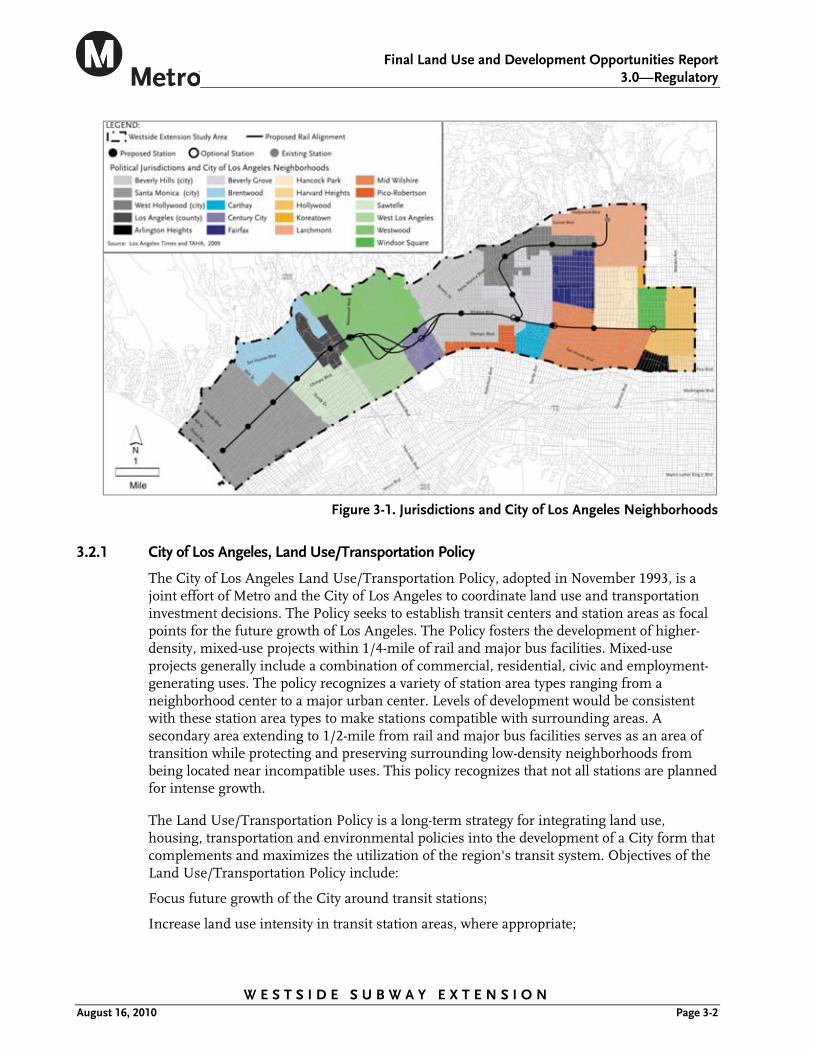
The Westside Extension Transit Corridor study area is east-west oriented and includes portions of five jurisdictions: the Cities of Los Angeles, West Hollywood, Beverly Hills, Santa Monica, and portions of unincorporated County of Los Angeles around the Veterans Administration (VA) Hospital. The study area generally extends north to Sunset and Hollywood Boulevards, east to Western Avenue, south to Pico Boulevard, and west to Ocean Avenue. The individual character of the neighborhoods and communities within these jurisdictions are discussed in detail in the Community Impacts section. The study area and corresponding jurisdictions are shown in Figure 3-1.
Final Land Use and Development Opportunities Report
3.0—Regulatory
W E S T S I D E S U B W A Y E X T E N S I O N August 16, 2010 Page 3-2
Figure 3-1. Jurisdictions and City of Los Angeles Neighborhoods
3.2.1 City of Los Angeles, Land Use/Transportation Policy
The City of Los Angeles Land Use/Transportation Policy, adopted in November 1993, is a joint effort of Metro and the City of Los Angeles to coordinate land use and transportation investment decisions. The Policy seeks to establish transit centers and station areas as focal points for the future growth of Los Angeles. The Policy fosters the development of higher-density, mixed-use projects within 1/4-mile of rail and major bus facilities. Mixed-use projects generally include a combination of commercial, residential, civic and employment-generating uses. The policy recognizes a variety of station area types ranging from a neighborhood center to a major urban center. Levels of development would be consistent with these station area types to make stations compatible with surrounding areas. A secondary area extending to 1/2-mile from rail and major bus facilities serves as an area of transition while protecting and preserving surrounding low-density neighborhoods from being located near incompatible uses. This policy recognizes that not all stations are planned for intense growth.
The Land Use/Transportation Policy is a long-term strategy for integrating land use, housing, transportation and environmental policies into the development of a City form that complements and maximizes the utilization of the region's transit system. Objectives of the Land Use/Transportation Policy include:
Focus future growth of the City around transit stations;
Increase land use intensity in transit station areas, where appropriate;

Final Land Use and Development Opportunities Report
3.0—Regulatory Framework
W E S T S I D E S U B W A Y E X T E N S I O N August 16, 2010 Page 3-3
Create a pedestrian oriented environment in the context of an enhanced urban environment; and
Accommodate mixed-use (commercial/residential) development.
3.2.2 City of Los Angeles, Residential/Accessory Services Zones and Density Bonus Ordinance
Chapter 1, Article 2, Sections 12.11.2 and 12.11.5 of the City of Los Angeles Municipal Code describe RAS3 and RAS4 Residential/Accessory Services (RAS) Zones, respectively. The purpose of RAS zones is to provide a mechanism to increase housing opportunities, enhance neighborhoods, and revitalize older commercial corridors. The RAS3 and RAS4 zones are intended as tools to accommodate projected population growth in mixed-use and residential projects that is compatible with existing residential neighborhoods along existing transportation corridors. The Density Bonus Ordinance was adopted by the City of Los Angeles and became effective on April 15, 2008 to comply with density requirements prescribed by Senate Bill 1818. Under the ordinance, density bonuses are provided for residential development projects that are located near transit stops leading to the increased development potential of transit corridors.
Many transportation corridors in the study area are compatible with the RAS and Density Bonus ordinance requirements and would enhance the residential component of these corridors by supporting walking, bicycling and transit use, as well as potentially reducing the need to drive to services provided within the community. Based on existing land use conditions within the study area, opportunities for the use of this ordinance exist at station areas in the City of Los Angeles. These opportunities would be explored under station area planning efforts conducted during the Preliminary Engineering Design phase of the project.
3.2.3 City of Los Angeles, Citywide General Plan Framework
The Citywide General Plan Framework (Framework), an element of the City of Los Angeles General Plan adopted in December 1996, is intended to guide the City’s long-range growth and development through the year 2010. The Framework establishes Citywide planning policies regarding land use, housing development, transportation, and provision of infrastructure and public services. The Framework’s transportation policies seek to develop transit alignments and station locations that maximize transit service in activity centers. Together, the Framework’s land use and transportation policies encourage development in these “targeted growth areas” by allowing transit-oriented development and calling for streamlined transportation analysis and mitigation procedures. The purpose of these development nodes is to allow the maintenance of existing land uses that are not located next to public transit to preserve existing neighborhoods.
Three broad themes run throughout the Framework: sustained mobility with greater accessibility, economic opportunity, and environmental quality. Major land use and transportation policies include:
Expand neighborhood transportation services and programs to enhance neighborhood accessibility;
Provide improved transportation services to support Citywide economic development activities related to economic revitalization initiatives;

Final Land Use and Development Opportunities Report
3.0—Regulatory
W E S T S I D E S U B W A Y E X T E N S I O N August 16, 2010 Page 3-4
Promote the development of transportation facilities and services that encourage transit ridership, including enhanced transit services, improved transit safety, and merchant incentives;
Support development in regional centers, community centers, major economic activity centers, and along mixed-use boulevards as designated in the Community Plans;
Encourage and seek the formation of public/private partnerships when developing centers and districts and provide appropriate transportation facilities and programs;
Seek opportunities for joint development projects that integrate land use and transportation facilities;
Promote the development of transit alignments and station locations that maximize transit service to activity centers and which permit the concentration of development around transit stations;
Promote the provision of shuttles and other services that increase access to and within regional centers and major economic activity areas to encourage growth and to mitigate traffic impacts of that growth;
Promote the enhancement of transit access to neighborhood districts, community and regional centers, and mixed-use boulevards;
Enhance pedestrian circulation in neighborhood districts, community centers, appropriate locations in regional centers, and along mixed-use boulevards; and
Promote direct pedestrian linkages between transit portals/platforms and adjacent commercial development through facilities orientation and design.
The Framework's land use policies identify transportation corridors and stations as the primary focal point of the City’s development. It is intended that a considerable mix of uses be accommodated to provide population support and enhance activity near transit stations. This encompasses a range of retail commercial, offices, personal services, entertainment, restaurants, and housing that serve both transit users and local residents. In 1974, the City allocated potential growth to activity centers, which were based strictly by density, and did not reflect the diversity of their functionality, land uses, physical form, character, and users. To represent this diversity, these centers have been redefined to neighborhood districts, mixed-use boulevards, and community, downtown and regional centers. Within these areas, the highest development intensities are targeted generally within one quarter mile of the transit stations. It is intended that a considerable mix of uses be accommodated to provide population support and enhance activity near the stations. This may encompass a range of retail commercial, offices, personal services, entertainment, restaurants, and housing that serve both transit users and local residents.
The Framework's transportation policies seek to develop transit alignments and station locations that maximize transit service in activity centers. Together, the Framework's land use and transportation policies encourage development in targeted growth areas by allowing more intense development than in non-targeted areas and calling for streamlined traffic analysis and mitigation procedures.

Final Land Use and Development Opportunities Report
3.0—Regulatory Framework
W E S T S I D E S U B W A Y E X T E N S I O N August 16, 2010 Page 3-5
3.2.4 City of Los Angeles General Plan’s Transportation Element
The Transportation Element of the City of Los Angeles General Plan, adopted in September 1999, establishes the following policies applicable to the proposed alternatives:
Establish high capacity transit service post-2010, and develop programs to foster transit ridership along the Wilshire Corridor (Wilshire/Western to I-405, serving Century City and Westwood);
Continue transit restructuring studies and other inter-agency efforts to reduce the cost and enhance the effectiveness of transit service, and improve coordination with adjoining jurisdictions in implementation of feasible measures as recommended in the transit restructuring studies; give full consideration to establishing separate transit zones;
Develop interactive transit information systems that bring customers more timely, accurate, and complete transit information;
Promote the multi-modal function of transit centers (bus and rail) through improved station design and management of curb lanes to facilitate transfers between modes; and
Identify and develop transit priority streets which serve regional centers, major economic activity areas and rail stations to enhance speed, quality, and safety of transit service.
3.2.5 City of Los Angeles General Plan’s Land Use Element
For land use planning purposes, the City of Los Angeles is divided into 35 Community Planning Areas. For each of these areas, a community plan has been adopted to establish land use designations, policies, objectives, and implementation programs. These plans are considered to be part of the Land Use Element of the Los Angeles General Plan and are the means through which Citywide land use policies are applied to specific development proposals. The individual plans relevant to the proposed project are discussed in greater detail in the following sections.
The study area contains the Brentwood-Pacific Palisades, Westwood, West Los Angeles, Hollywood, and Wilshire Community Plan Areas within the City of Los Angeles. These community plan areas contain numerous land use policies that encourage mixed-use and transit supportive uses. Community plan areas within the study area are shown in Figure 3-1.
The community plans within the study area discuss goals and objectives for developing and maintaining strong and competitive commercial sectors. Development would include a mixture of land uses, promote economic vitality, and serve the needs of the community through well-designed, safe, and accessible areas, while preserving historic and cultural character. The community plans indicate that new development should be focused around future transit systems, while minimizing adverse impacts.
Each of the community plans include goals, objectives, and policies regarding the appropriate land uses that would support a public transit system that improves mobility with convenient alternatives to automobile travel, fostering of transportation demand strategies, the development of non- motorized transportation options, and the coordination of activities with other jurisdictions.

Final Land Use and Development Opportunities Report
3.0—Regulatory
W E S T S I D E S U B W A Y E X T E N S I O N August 16, 2010 Page 3-6
3.2.6 Brentwood-Palisades Community Plan
The Brentwood-Palisades Community Plan is consistent with the City of Los Angeles’ Land Use/Transportation Policy and includes the following policies which seek to develop a public transit system that improves mobility with convenient alternatives to automobile travel:
Retain higher residential densities near commercial centers and major bus routes where public service facilities, utilities and topography will accommodate such development and circulation;
Promote housing in mixed-use projects in pedestrian-oriented areas and transit corridors; and
Develop an intermodal mass transportation plan to implement linkages to future mass transit service.
3.2.7 Westwood Community Plan
The Westwood Community Plan is consistent with the City of Los Angeles’ Land Use/Transportation Policy and includes the following policies which seek to increase transit mode share:
Locate higher density residential within designated multiple family areas and near commercial centers and major bus routes where facilities and infrastructure will support this development;
Develop an intermodal mass transportation plan to implement linkages to future mass transit service; and
Promote the development of transportation facilities and services that encourage transit ridership, increase vehicle occupancy, and improve pedestrian and bicycle access.
3.2.8 West Los Angeles Community Plan
The West Los Angeles Community Plan is consistent with the City of Los Angeles’ Land Use/Transportation Policy and includes the following policies to reduce vehicular trips and congestion and develop new housing in proximity to adequate services and facilities:
Locate higher density residential within designated multiple family areas and near commercial centers and major bus routes where public service facilities and infrastructure will support this development;
Promote mixed-use projects along transit corridors and in appropriate commercial areas;
Develop an intermodal mass transportation plan to implement linkages to future mass transit service; and
Promote the development of transportation facilities and services that encourage transit ridership, increase vehicle occupancy, and improve pedestrian and bicycle access.
3.2.9 Hollywood Community Plan
The Hollywood Community Plan is consistent with the City of Los Angeles’ Land Use/Transportation Policy and includes the following policies:
Prepare station area plans for higher density development around proposed Metro rail stations; and

Final Land Use and Development Opportunities Report
3.0—Regulatory Framework
W E S T S I D E S U B W A Y E X T E N S I O N August 16, 2010 Page 3-7
Continue planning and improving the public transportation system for the community, including people-mover systems in high intensity areas as well as the proposed Metro rail system.
3.2.10 Wilshire Community Plan
The Wilshire Community Plan is consistent with the City of Los Angeles’ Land Use/Transportation Policy and includes the following policies to guide development:
Encourage higher density residential uses near major public transportation centers;
Develop coordinated intermodal mass transportation plan to implement linkages to future public transit services; and
Promote the development of transportation facilities and services that encourage higher transit ridership, increase vehicle occupancy, and improve pedestrian and bicycle access.
3.2.11 Specific Plans
A specific plan is a tool for the systematic implementation of the General Plan. It effectively establishes a link between implementing policies of the General Plan and the individual development proposals in a defined area. A specific plan may be as general as setting forth broad policy concepts, or as detailed as providing direction to every facet of development from the type, location and intensity of uses to the design and capacity of infrastructure; from the resources used to finance public improvements to the design guidelines of a subdivision. Specific Plans from differing jurisdictions would guide the design and development of the proposed project at defined locations along the alignment.
3.2.12 Park Mile Specific Plan
The Park Mile Specific Plan was adopted in 1980 and amended in 1987 by the City of Los Angeles Planning Commission. The Park Mile area is located along Wilshire Boulevard bound by Wilton Place to the east, Highland Avenue to the west, 6th Street to the north, and 8th Street to the south. The Park Mile Specific Plan was adopted to preserve the low-density, single-family residential nature of the area and promote a park-like setting.
3.2.13 West Los Angeles Transportation Improvement and Mitigation Specific Plan
The West Los Angeles Transportation Improvement and Mitigation Specific Plan was adopted on March 8, 1997 to provide a funding mechanism for transportation improvements through transportation impact assessment fees, which become necessary as a result of projected new development within the plan area. The specific plan area includes all or parts of the Westwood, West Los Angeles, Brentwood-Palisades, and the Palms-Mar Vista-Del Rey district plan areas generally bounded by the City of Beverly Hills, Beverwil Drive, Castle Heights Avenue, National Boulevard, and Hughes Avenue on the east; Sunset Boulevard on the north; the City of Santa Monica and Centinela Avenue on the west; and Venice Boulevard on the south. The specific plan also establishes a phased development of land uses and promotes transportation options which mitigate the impacts of traffic.
3.2.14 Wilshire-Westwood Scenic Corridor Specific Plan
The Wilshire-Westwood Corridor Specific Plan was adopted on March 2, 2005 to minimize traffic and parking problems along Wilshire Boulevard, enhance the aesthetic qualities of

Final Land Use and Development Opportunities Report
3.0—Regulatory
W E S T S I D E S U B W A Y E X T E N S I O N August 16, 2010 Page 3-8
the specific plan area, encourage more open space, reduce the impact of high-density development, and reduce the impact of shadows caused by high-rise buildings within the specific plan area. The specific plan area is generally bounded by Linbrook Drive to the north, Club View Avenue to the east, Ashton Avenue to the south, and Glendon Avenue to the west. The specific plan contains restrictions on development intensity, parking, shadow impacts, and excavation during construction.
3.2.15 Century City North Specific Plan
The Century City North Specific Plan (CCNSP) was adopted on November 24, 1981, to guide development and redevelopment to ensure adequate transportation and other public facilities for the high-density center of Century City, while addressing compatibility with nearby low-density residential areas. The CCNSP establishes a phasing strategy, consisting of two development phases, to guide development and provide adequate infrastructure with the build-out of the existing zoning for the area. The CCNSP limits development in Century City through the assignment of development rights called Cumulative Automobile Trip Generation Potential (CATGP) Trips to parcels within the CCNSP. The first phase of the CCNSP (Phase I) allowed development until projects had used a certain number of development rights or CATGP Trips and required specific street dedications and roadway improvements on Avenue of the Stars, Century Park East, Century Park West, Constellation Boulevard, Pico Boulevard, and Santa Monica Boulevard. The CCNSP also has a second phase of development to allow for additional development after the Phase I is completed. The second phase of development began when the maximum allowable building permits had been issued for Phase I (15,800 trips) and when all public improvements set forth in the CCNSP Ordinance were completed. Pursuant to City of Los Angeles Case No. CF 98-0672, all Phase I improvements have been completed and the CCNSP is now in the second phase, which has a maximum of 10,156.789 allowable trips.
3.2.16 Westside Cities Multimodal Mobility Study
The Westside Cities Multimodal Mobility Study was adopted in October of 2005 and aims to identify multimodal mobile interface opportunities for the Westside Cities, which includes but is not limited to developing transportation networks, maximizing transit efficiency, balancing the use of public right-of-way, and linking facilities and coordinating services. The organization of Westside Cities includes the Cities of Beverly Hills, Culver City, Santa Monica, and West Hollywood. The study contains the following applicable policies:
Creation of a rail line through West Hollywood connected to regional rail system;
Creation of major transportation hubs to link Metro, pedestrian, bicycle, parking, and car sharing resources;
Addition of multi-modal capacity in Lincoln, Venice, and Robertson/La Cienega/Fairfax corridors;
Creation of land use and parking incentives coordinated among cities
Creation of extensive local public transit circulators on fixed or flexible routes between neighborhoods and major bus and rail transit lines
Creation of alternative multi-modal linkage from Westside to San Fernando Valley

Final Land Use and Development Opportunities Report
3.0—Regulatory Framework
W E S T S I D E S U B W A Y E X T E N S I O N August 16, 2010 Page 3-9
3.2.17 Redevelopment Plans
Many neighborhood areas become dilapidated and need revitalization. The principal goal of a redevelopment plan is to guide an agency’s redevelopment efforts to eliminate blighting influences. In addition, the affordable housing component of redevelopment plans provides a mechanism to monitor its progress in meeting affordable housing obligations under the California Redevelopment Law and the affordable housing needs of a community.
3.2.18 CRA/LA Hollywood Redevelopment Project
The Hollywood Redevelopment Plan was adopted by the Los Angeles City Council on May 7, 1986. This plan sets forth an array of goals that include encouraging economic development; promoting and retaining the entertainment industry; revitalizing the historic core; preserving and expanding housing for all income groups; meeting social needs of area residents; providing urban design guidelines; and preserving historically significant structures. The Hollywood Redevelopment Project area is generally bounded by Franklin Avenue on the north, Serrano Avenue on the east, Santa Monica Boulevard and Fountain Avenue on the south and La Brea Avenue on the west. The Hollywood Redevelopment Project supports and encourages a circulation system which will improve the quality of life in Hollywood, including pedestrian, automobile, parking and mass transit systems with an emphasis on serving existing facilities and meeting future needs.
3.2.19 CRA/LA Mid-City Recovery Redevelopment Project
The Mid-City Redevelopment Project was adopted by the Los Angeles City Council on May 10, 1996. This plan sets forth goals that include increasing employment, business and investment opportunities; encouraging the development of social service facilities; attracting private investment and promoting a thriving commercial environment to enhance economic opportunities. The project area consists of five non-contiguous areas, including the commercial corridors along Pico, Venice, Washington, Adams, and Jefferson Boulevards generally between Western Avenue and Fairfax Avenue, and Crenshaw Boulevard between the Santa Monica Freeway and Martin Luther King, Jr. Boulevard. The Mid-City Redevelop-ment Project supports and encourages a circulation system which will improve the quality of life in Mid-City, including pedestrian, automobile, parking and mass transit systems with an emphasis on serving existing facilities and meeting future needs.
3.2.20 CRA/LA Wilshire Center-Koreatown Redevelopment Project
The Wilshire Center-Koreatown Redevelopment Project was adopted by the Los Angeles City Council on December 13, 1995. This plan sets forth goals that promote business retention and expansion, attracting new businesses and developing public improvements. The Wilshire Center-Koreatown Redevelopment Project area is generally bounded by Fifth Street on the north, Twelfth Street on the south, Hoover Street on the east, and Eastern Avenue and Wilton Place on the west. The project contains policies that provide for an efficient circulation system coordinated with land uses and densities to accommodate traffic, and encourages the improvement of public transit services in coordination with other public improvements.

Final Land Use and Development Opportunities Report
3.0—Regulatory
W E S T S I D E S U B W A Y E X T E N S I O N August 16, 2010 Page 3-10
3.2.21 City of West Hollywood, General Plan
The West Hollywood General Plan, originally adopted in 1988 is a long-term policy docu-ment that balances the commercial, residential and development needs of the community. The City of West Hollywood is currently in the beginning phase of updating the General Plan. The General Plan Update seeks to create a sustainable infrastructure that will help the development of the inter-modal transportation system, and keep the city economically robust, socially equitable, and environmentally healthy. The following policies of the existing General Plan apply to the proposed project:
Encourage residents, employers, and employees to minimize automobile use and use public transportation;
Join as a committed supporter of Westside initiatives for light rail which benefit and do not adversely impact the City of West Hollywood;
Continue to coordinate with Southern California Regional Transit District (SCRTD), Los Angeles (LACTC)1, and other regional transit agencies to assess the need for the expansion or adjustment of fixed-route service; and
Coordinate planning efforts with SCRTD to provide efficient public transportation to future Metro transit stations to serve both local residents and users destined to the City of West Hollywood.
3.2.22 City of Beverly Hills, General Plan
The Beverly Hills General Plan was adopted by the Beverly Hills City Council on May 17, 1977, and seeks to preserve the neighborhoods and facilitate through travel traffic. The General Plan supports a mass transit system that is underground, does not use existing right-of way on arterials, and does not interfere with automobile traffic. The City of Beverly Hills has been in the process of updating the General Plan since 2005 and released a Draft General Plan in August of 2008. The Draft General Plan Update contains the following applicable policies:
Collaborate with local transit agencies to: develop programs and educate employers about employee rideshare and transit; promote mass transit ridership through careful planning of routes; and develop a local point of contact for potential ride-sharers;
Support the extension of the Metro subway extension along Wilshire Boulevard through the city with stations at Beverly/Rodeo and La Cienega to enhance transit service and increase transit ridership within the city and West Los Angeles;
Consider a variety of transit services including heavy rail, light rail transit, bus rapid transit, trolleys, enhanced buses, express buses, local buses, school buses, and neighborhood shuttles to meet the needs of residents, workers, and visitors;
Support a well-designed transit system to meet the mobility needs of residents and visitors including seniors, the disabled, and transit-dependent persons;
Work collaboratively with regional agencies and adjacent jurisdictions to improve transit service, accessibility, frequency, and connectivity, resulting in increased ridership and fewer personal automobile trips;
1The SCRTD and LACTC have since merged to become the Los Angeles County Metropolitan Transportation Authority.

Final Land Use and Development Opportunities Report
3.0—Regulatory Framework
W E S T S I D E S U B W A Y E X T E N S I O N August 16, 2010 Page 3-11
Support increased frequency transit service and capital investment to serve high-density employment, commercial, residential, and mixed-use areas and activity centers;
Require developer contributions for transit facilities and improvements;
Review development projects in consideration of transit right-of-way needs;
Create an interconnected transportation system that allows a shift in travel from private passenger vehicles to alternative modes, including public transit, ride sharing, car-sharing, bicycling and walking;
Prioritize growth and accommodate the highest development densities in proximity to major transit corridors and rail transit stations as developed in the future;
Accommodate a balanced mix of land uses and require that development be located and designed to enable residents access by walking, bicycle, or public transit to jobs, commerce, entertainment, services, and recreation, thereby reducing automobile use, energy consumption, air pollution, and greenhouse gases;
Allow the greatest development on properties in proximity of public transit stops, stations, and corridors to facilitate its access and use in lieu of the automobile;
Accommodate office, retail, residential, mixed use, live/work and live/work development that facilitates access to and by public transit and reduce automobile trips, pollution, and energy consumption;
Require the inclusion of affordable housing units as a component of any residential development in proximity of the transit station;
Promote the development of more parking structures to serve transit riders, building tenants, and residents and require that its ground floor be occupied by retail uses that induce pedestrian activity; and
Accommodate higher density development to maximize transit access and use on implementation of future rail transit improvements, with maximum intensities in buildings using the air rights above the transit station/portal that provide direct linkages to the transit line.
3.2.23 City of Santa Monica, General Plan.
The City of Santa Monica General Plan was adopted in 1984, and seeks to preserve the existing neighborhoods and focus growth to downtown Santa Monica, the Special Office District (Olympic Boulevard, east of 20th Street), and Wilshire Boulevard. The Circulation Element of the existing General Plan identifies Wilshire Boulevard as one of three potential corridors for mass transit and promotes a transit station located in downtown Santa Monica. The City of Santa Monica is in the process of updating the Land Use and Circulation Elements of the General Plan. The Framework for this Land Use and Circulation Element contains the following applicable policies:
Travel on bicycle and transit should be time-competitive with autos, where possible;
The City shall develop design guidelines and management tools for all its streets, to ensure that each street supports the land uses along it and provides an optimal accommodation for all modes of transportation;
Final Land Use and Development Opportunities Report
3.0—Regulatory
W E S T S I D E S U B W A Y E X T E N S I O N August 16, 2010 Page 3-12
The City shall continue to collaborate with regional transit partners to achieve seamless transfers between systems, including scheduling, ticketing and shared fare systems;
The City shall work with transit providers to pursue direct transit connections for Santa Monica residents to regional destinations;
The City shall support a future Westside subway extension as a desirable project, with the City's priority for first completing of the Exposition Light Rail line to downtown Santa Monica;
The City shall support transit-oriented development patterns and uses that are known to generate a high level of transit ridership;
Rail stations shall be designed and located to support bus access and to reduce the transfer penalty between buses and rail;
The City shall design incentives to focus development in locations best served by transit; and
Integrating land use and transportation and locating new activity centers along existing and proposed transit corridors.
3.2.24 County of Los Angeles, General Plan
The Los Angeles County General Plan was adopted on November 25, 1980 and provides guidelines for unincorporated areas of Los Angeles County that are located within the study area. Jurisdiction of this plan applies to the area near West Los Angeles, named the Sawtelle/VA Hospital district, located in the western portion of the study area. The Los Angeles County Department of Regional Planning is in the process of updating the General Plan, and released a Draft General Plan in 2008. Both plans contain goals, objectives, and policies relative to the development of the unincorporated areas of Los Angeles County and the integration of transit into this framework. These policies include:
3.2.25 Existing County of Los Angeles General Plan
Promote the development of an improved public transportation system to link regional centers and support urban revitalization;
Promote a more concentrated urban pattern, focus new development in suitable locations, adopt a moderate population growth equivalent to natural increase;
Promote the efficient use of land through a more concentrated pattern of urban development, including the focusing of new urban growth into areas of suitable land;
Maintain a balance between increased intensity of development and the capacity of needed facilities, such as transportation, water and sewage systems;
Revitalize declining portions of existing urban development, with particular attention to deteriorated industrial and low-income residential areas;
Focus intensive urban uses in an interdependent system of activity centers located to effectively provide services throughout the urban area and supported by adequate public transportation facilities;
Encourage the location of medium and high density housing in close proximity to regional multipurpose centers;

Final Land Use and Development Opportunities Report
3.0—Regulatory Framework
W E S T S I D E S U B W A Y E X T E N S I O N August 16, 2010 Page 3-13
Emphasize the location of low and moderate income housing within easy commuting range of multipurpose and single purpose centers with high concentrations of employment; and
Support the development of a transportation system that will make a positive contribution to the improvement of air quality.
3.2.26 Draft County of Los Angeles General Plan Update 2008
Promote and develop transit oriented districts along major transit corridors;
Expand the availability of transportation options throughout the county especially those that reduce automobile dependence;
Maximize the level of connectivity in transportation systems and community-level designs; and
Expand inter-jurisdictional cooperation to ensure a seamless, inter-modal, and multi-modal regional transportation system.
3.2.27 Transit Oriented District Ordinance
Title 22 of the County of Los Angeles Code contains a Transit Oriented District Ordinance (22.44.400) which contains incentives and development standards for residential and commercial uses in designated transit oriented districts. Incentives focus on a 25 percent reduction in fees and up to a 40 percent reduction on parking requirements, while specific development standards are provided for lighting, design, parking, pedestrian areas, public spaces, and streets and sidewalks.