Land Surface Temperature from Geostationary Satellites · I.F. Trigo (1,2), S.C. Freitas (1),C....
1
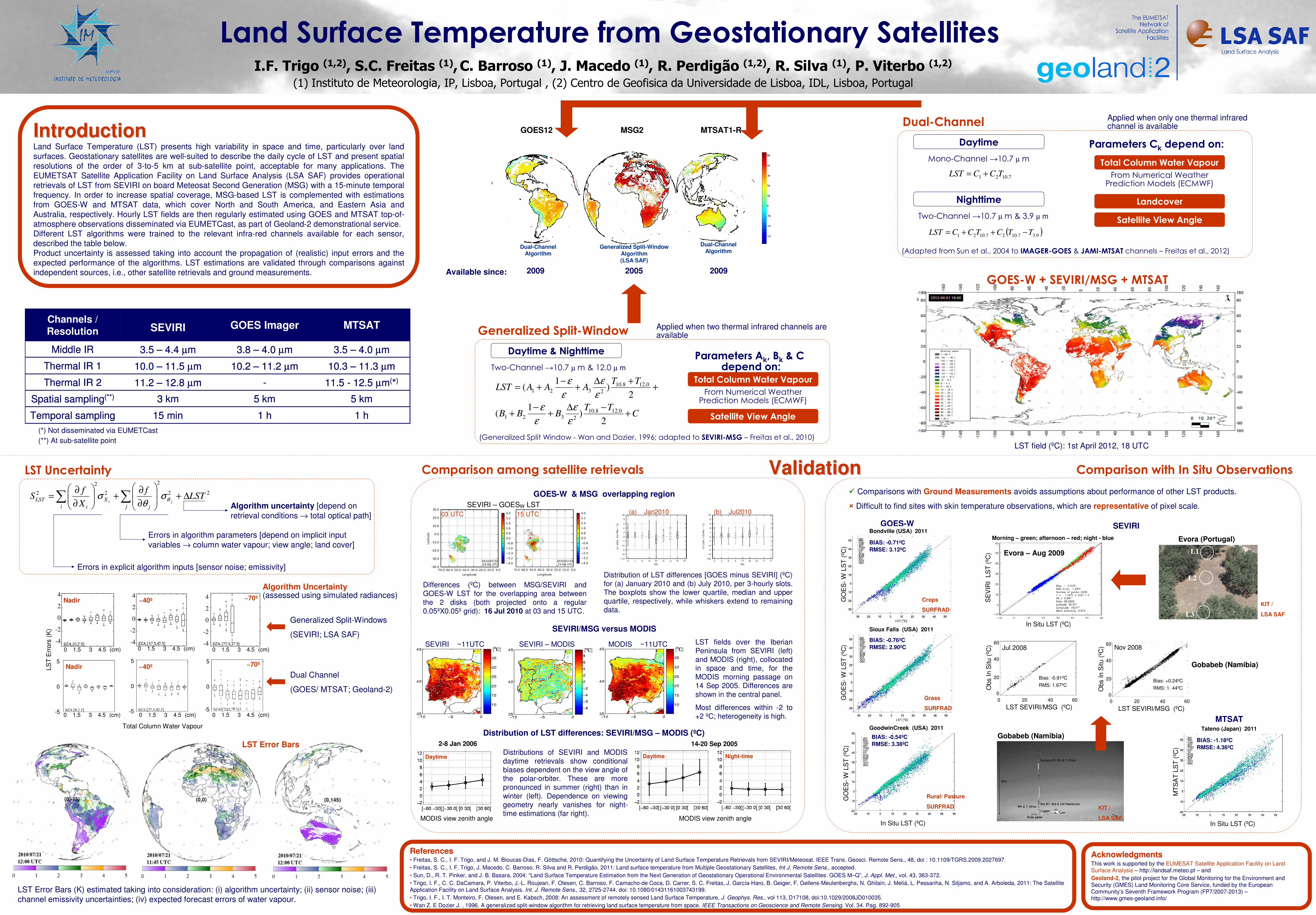
In Situ LST (ºC) Land Surface Temperature from Geostationary Satellites I.F. Trigo (1,2) , S.C. Freitas (1) , C. Barroso (1) , J. Macedo (1) , R. Perdigão (1,2) , R. Silva (1) , P. Viterbo (1,2) (1) Instituto de Meteorologia, IP, Lisboa, Portugal , (2) Centro de Geofisica da Universidade de Lisboa, IDL, Lisboa, Portugal Introduction Introduction Land Surface Temperature (LST) presents high variability in space and time, particularly over land surfaces. Geostationary satellites are well-suited to describe the daily cycle of LST and present spatial resolutions of the order of 3-to-5 km at sub-satellite point, acceptable for many applications. The EUMETSAT Satellite Application Facility on Land Surface Analysis (LSA SAF) provides operational retrievals of LST from SEVIRI on board Meteosat Second Generation (MSG) with a 15-minute temporal frequency. In order to increase spatial coverage, MSG-based LST is complemented with estimations from GOES-W and MTSAT data, which cover North and South America, and Eastern Asia and Australia, respectively. Hourly LST fields are then regularly estimated using GOES and MTSAT top-of- atmosphere observations disseminated via EUMETCast, as part of Geoland-2 demonstrational service. Different LST algorithms were trained to the relevant infra-red channels available for each sensor, described the table below. Product uncertainty is assessed taking into account the propagation of (realistic) input errors and the expected performance of the algorithms. LST estimations are validated through comparisons against independent sources, i.e., other satellite retrievals and ground measurements. 11.5 - 12.5 μm ( * ) - 11.2 – 12.8 μm Thermal IR 2 5 km 5 km 3 km Spatial sampling (**) 1 h 1 h 15 min Temporal sampling 10.3 – 11.3 μm 10.2 – 11.2 μm 10.0 – 11.5 μm Thermal IR 1 3.5 – 4.0 μm 3.8 – 4.0 μm 3.5 – 4.4 μm Middle IR MTSAT GOES Imager SEVIRI Channels / Resolution 11.5 - 12.5 μm ( * ) - 11.2 – 12.8 μm Thermal IR 2 5 km 5 km 3 km Spatial sampling (**) 1 h 1 h 15 min Temporal sampling 10.3 – 11.3 μm 10.2 – 11.2 μm 10.0 – 11.5 μm Thermal IR 1 3.5 – 4.0 μm 3.8 – 4.0 μm 3.5 – 4.4 μm Middle IR MTSAT GOES Imager SEVIRI Channels / Resolution GOES12 MSG2 MTSAT1-R Dual-Channel Algorithm Dual-Channel Algorithm Generalized Split-Window Algorithm (LSA SAF) ( ) 9 . 3 7 . 10 2 7 . 10 2 1 T T C T C C LST - + + = Dual-Channel Applied when only one thermal infrared channel is available (Adapted from Sun et al., 2004 to IMAGER-GOES & JAMI-MTSAT channels – Freitas et al., 2012) Daytime 7 . 10 2 1 T C C LST + = Nighttime Mono-Channel →10.7 μ m Two-Channel →10.7 μ m & 3.9 μ m Parameters C k depend on: Total Column Water Vapour From Numerical Weather Prediction Models (ECMWF) Landcover Satellite View Angle Generalized Split-Window Applied when two thermal infrared channels are available (Generalized Split Window - Wan and Dozier, 1996; adapted to SEVIRI-MSG – Freitas et al., 2010) Daytime & Nighttime Two-Channel →10.7 μ m & 12.0 μ m C T T B B B T T A A A LST + - Δ + - + + + Δ + - + = 2 ) 1 ( 2 ) 1 ( 0 . 12 8 . 10 2 3 2 1 0 . 12 8 . 10 2 3 2 1 ε ε ε ε ε ε ε ε Parameters A k , B k & C depend on: Total Column Water Vapour From Numerical Weather Prediction Models (ECMWF) Satellite View Angle 2 2 2 2 2 2 LST f X f S j j X i i LST j i Δ + ∂ ∂ + ∂ ∂ = ∑ ∑ θ σ θ σ References References • Freitas, S. C., I. F. Trigo, and J. M. Bioucas-Dias, F. Göttsche, 2010: Quantifying the Uncertainty of Land Surface Temperature Retrievals from SEVIRI/Meteosat. IEEE Trans. Geosci. Remote Sens., 48, doi : 10.1109/TGRS.2009.2027697. • Freitas, S. C., I. F. Trigo, J. Macedo, C. Barroso, R. Silva and R. Perdigão, 2011: Land surface temperature from Multiple Geostationary Satellites, Int J. Remote Sens., accepted. • Sun, D., R. T. Pinker, and J. B. Basara, 2004: “Land Surface Temperature Estimation from the Next Generation of Geostationary Operational Environmental Satellites: GOES M–Q”, J. Appl. Met., vol. 43, 363-372. • Trigo, I. F., C. C. DaCamara, P. Viterbo, J.-L. Roujean, F. Olesen, C. Barroso, F. Camacho-de Coca, D. Carrer, S. C. Freitas, J. García-Haro, B. Geiger, F. Gellens-Meulenberghs, N. Ghilain, J. Meliá, L. Pessanha, N. Siljamo, and A. Arboleda, 2011: The Satellite Application Facility on Land Surface Analysis. Int. J. Remote Sens., 32, 2725-2744. doi: 10.1080/01431161003743199. • Trigo, I. F., I. T. Monteiro, F. Olesen, and E. Kabsch, 2008: An assessment of remotely sensed Land Surface Temperature, J. Geophys. Res., vol 113, D17108, doi:10.1029/2008JD010035. • Wan Z. E Dozier J. , 1996. A generalized split-window algorithm for retrieving land surface temperature from space. IEEE Transactions on Geoscience and Remote Sensing. Vol. 34. Pag. 892-905 LST Uncertainty Algorithm uncertainty [depend on retrieval conditions → total optical path] Errors in algorithm parameters [depend on implicit input variables → column water vapour; view angle; land cover] Errors in explicit algorithm inputs [sensor noise; emissivity] 4 2 0 -2 -4 0 1.5 3 4.5 (cm) 4 2 0 -2 -4 0 1.5 3 4.5 (cm) 5 0 -5 0 1.5 3 4.5 (cm) 5 0 -5 0 1.5 3 4.5 (cm) 5 0 -5 0 1.5 3 4.5 (cm) 4 2 0 -2 -4 0 1.5 3 4.5 (cm) LST Errors (K) Total Column Water Vapour Nadir Nadir ~40º ~40º ~70º ~70º Algorithm Uncertainty (assessed using simulated radiances) Generalized Split-Windows (SEVIRI; LSA SAF) Dual Channel (GOES/ MTSAT; Geoland-2) LST Error Bars LST Error Bars (K) estimated taking into consideration: (i) algorithm uncertainty; (ii) sensor noise; (iii) channel emissivity uncertainties; (iv) expected forecast errors of water vapour. Available since: 2009 2009 2005 Validation Validation Acknowledgments Acknowledgments This work is supported by the EUMESAT Satellite Application Facility on Land Surface Analysis – http://landsaf.meteo.pt – and Geoland-2, the pilot project for the Global Monitoring for the Environment and Security (GMES) Land Monitoring Core Service, funded by the European Community’s Seventh Framework Program (FP7/2007-2013) – http://www.gmes-geoland.info/ Comparison among satellite retrievals GOES-W & MSG overlapping region Comparison with In Situ Observations SEVIRI – GOES W LST Distribution of LST differences [GOES minus SEVIRI] (ºC) for (a) January 2010 and (b) July 2010, per 3-hourly slots. The boxplots show the lower quartile, median and upper quartile, respectively, while whiskers extend to remaining data. (a) Jan2010 (b) Jul2010 Differences (ºC) between MSG/SEVIRI and GOES-W LST for the overlapping area between the 2 disks (both projected onto a regular 0.05ºX0.05º grid): 16 Jul 2010 at 03 and 15 UTC. 03 UTC 15 UTC SEVIRI/MSG versus MODIS SEVIRI ~11UTC MODIS ~11UTC SEVIRI – MODIS LST fields over the Iberian Peninsula from SEVIRI (left) and MODIS (right), collocated in space and time, for the MODIS morning passage on 14 Sep 2005. Differences are shown in the central panel. Most differences within -2 to +2 ºC; heterogeneity is high. 2-8 Jan 2006 Daytime 14-20 Sep 2005 Night-time Daytime Distributions of SEVIRI and MODIS daytime retrievals show conditional biases dependent on the view angle of the polar-orbiter. These are more pronounced in summer (right) than in winter (left). Dependence on viewing geometry nearly vanishes for night- time estimations (far right). Distribution of LST differences: SEVIRI/MSG – MODIS (ºC) MODIS view zenith angle MODIS view zenith angle Comparisons with Ground Measurements avoids assumptions about performance of other LST products. Difficult to find sites with skin temperature observations, which are representative of pixel scale. GOES-W MTSAT SEVIRI Bondville (USA) 2011 Sioux Falls (USA) 2011 GoodwinCreek (USA) 2011 Crops SURFRAD Grass SURFRAD Rural/ Pasture SURFRAD BSRN BIAS: -0.71ºC RMSE: 3.12ºC BIAS: -0.76ºC RMSE: 2.90ºC BIAS: -0.54ºC RMSE: 3.38ºC GOES- W LST (ºC) GOES- W LST (ºC) GOES- W LST (ºC) In Situ LST (ºC) Tateno (Japan) 2011 BIAS: -1.18ºC RMSE: 4.36ºC MTSAT LST (ºC) Morning – green; afternoon – red; night - blue Evora – Aug 2009 In Situ LST (ºC) L1 L2 L3 Evora (Portugal) KIT / LSA SAF SEVIRI LST (ºC) 60 40 20 0 Obs In Situ (ºC) 0 20 40 60 LST SEVIRI/MSG (ºC) Nov 2008 Bias: +0.24ºC RMS: 1. 44ºC 60 40 20 0 Obs In Situ (ºC) 0 20 40 60 LST SEVIRI/MSG (ºC) Jul 2008 Bias: -0.91ºC RMS: 1.67ºC Gobabeb (Namibia) KIT / LSA SAF Gobabeb (Namibia) (*) Not disseminated via EUMETCast (**) At sub-satellite point GOES-W + SEVIRI/MSG + MTSAT LST field (ºC): 1st April 2012, 18 UTC
Transcript of Land Surface Temperature from Geostationary Satellites · I.F. Trigo (1,2), S.C. Freitas (1),C....
In Situ LST (ºC)
Land Surface Temperature from Geostationary SatellitesI.F. Trigo (1,2), S.C. Freitas (1),C. Barroso (1), J. Macedo (1), R. Perdigão (1,2), R. Silva (1), P. Viterbo (1,2)
(1) Instituto de Meteorologia, IP, Lisboa, Portugal , (2) Centro de Geofisica da Universidade de Lisboa, IDL, Lisboa, Portugal
IntroductionIntroductionLand Surface Temperature (LST) presents high variability in space and time, particularly over land
surfaces. Geostationary satellites are well-suited to describe the daily cycle of LST and present spatial
resolutions of the order of 3-to-5 km at sub-satellite point, acceptable for many applications. The
EUMETSAT Satellite Application Facility on Land Surface Analysis (LSA SAF) provides operational
retrievals of LST from SEVIRI on board Meteosat Second Generation (MSG) with a 15-minute temporal
frequency. In order to increase spatial coverage, MSG-based LST is complemented with estimations
from GOES-W and MTSAT data, which cover North and South America, and Eastern Asia and
Australia, respectively. Hourly LST fields are then regularly estimated using GOES and MTSAT top-of-
atmosphere observations disseminated via EUMETCast, as part of Geoland-2 demonstrational service.
Different LST algorithms were trained to the relevant infra-red channels available for each sensor,
described the table below.
Product uncertainty is assessed taking into account the propagation of (realistic) input errors and the
expected performance of the algorithms. LST estimations are validated through comparisons against
independent sources, i.e., other satellite retrievals and ground measurements.
11.5 - 12.5 µm(*)-11.2 – 12.8 µmThermal IR 2
5 km5 km3 kmSpatial sampling(**)
1 h1 h15 minTemporal sampling
10.3 – 11.3 µm10.2 – 11.2 µm10.0 – 11.5 µmThermal IR 1
3.5 – 4.0 µm3.8 – 4.0 µm3.5 – 4.4 µmMiddle IR
MTSATGOES ImagerSEVIRIChannels /
Resolution
11.5 - 12.5 µm(*)-11.2 – 12.8 µmThermal IR 2
5 km5 km3 kmSpatial sampling(**)
1 h1 h15 minTemporal sampling
10.3 – 11.3 µm10.2 – 11.2 µm10.0 – 11.5 µmThermal IR 1
3.5 – 4.0 µm3.8 – 4.0 µm3.5 – 4.4 µmMiddle IR
MTSATGOES ImagerSEVIRIChannels /
Resolution
GOES12 MSG2 MTSAT1-R
Dual-ChannelAlgorithm
Dual-ChannelAlgorithm
Generalized Split-Window
Algorithm
(LSA SAF)
( )9.37.1027.1021
TTCTCCLST −++=
Dual-Channel Applied when only one thermal infrared channel is available
(Adapted from Sun et al., 2004 to IMAGER-GOES & JAMI-MTSAT channels – Freitas et al., 2012)
Daytime
7.1021TCCLST +=
Nighttime
Mono-Channel →10.7 µ m
Two-Channel →10.7 µ m & 3.9 µ m
Parameters Ck depend on:
Total Column Water Vapour
From Numerical Weather Prediction Models (ECMWF)
Landcover
Satellite View Angle
Generalized Split-Window Applied when two thermal infrared channels are available
(Generalized Split Window - Wan and Dozier, 1996; adapted to SEVIRI-MSG – Freitas et al., 2010)
Daytime & Nighttime
Two-Channel →10.7 µ m & 12.0 µ m
CTT
BBB
TTAAALST
+−∆
+−
+
++∆
+−
+=
2)
1(
2)
1(
0.128.10
2321
0.128.10
2321
ε
ε
ε
εε
ε
ε
ε
Parameters Ak, Bk & C depend on:
Total Column Water Vapour
From Numerical Weather Prediction Models (ECMWF)
Satellite View Angle
22
2
2
2
2 LSTf
X
fS
j j
X
i i
LST ji∆+
∂
∂+
∂
∂= ∑∑ θσ
θσ
ReferencesReferences• Freitas, S. C., I. F. Trigo, and J. M. Bioucas-Dias, F. Göttsche, 2010: Quantifying the Uncertainty of Land Surface Temperature Retrievals from SEVIRI/Meteosat. IEEE Trans. Geosci. Remote Sens., 48, doi : 10.1109/TGRS.2009.2027697.
• Freitas, S. C., I. F. Trigo, J. Macedo, C. Barroso, R. Silva and R. Perdigão, 2011: Land surface temperature from Multiple Geostationary Satellites, Int J. Remote Sens., accepted.
• Sun, D., R. T. Pinker, and J. B. Basara, 2004: “Land Surface Temperature Estimation from the Next Generation of Geostationary Operational Environmental Satellites: GOES M–Q”, J. Appl. Met., vol. 43, 363-372.
• Trigo, I. F., C. C. DaCamara, P. Viterbo, J.-L. Roujean, F. Olesen, C. Barroso, F. Camacho-de Coca, D. Carrer, S. C. Freitas, J. García-Haro, B. Geiger, F. Gellens-Meulenberghs, N. Ghilain, J. Meliá, L. Pessanha, N. Siljamo, and A. Arboleda, 2011: The Satellite
Application Facility on Land Surface Analysis. Int. J. Remote Sens., 32, 2725-2744. doi: 10.1080/01431161003743199.
• Trigo, I. F., I. T. Monteiro, F. Olesen, and E. Kabsch, 2008: An assessment of remotely sensed Land Surface Temperature, J. Geophys. Res., vol 113, D17108, doi:10.1029/2008JD010035.
• Wan Z. E Dozier J. , 1996. A generalized split-window algorithm for retrieving land surface temperature from space. IEEE Transactions on Geoscience and Remote Sensing. Vol. 34. Pag. 892-905
LST Uncertainty
Algorithm uncertainty [depend on
retrieval conditions → total optical path]
Errors in algorithm parameters [depend on implicit input
variables → column water vapour; view angle; land cover]
Errors in explicit algorithm inputs [sensor noise; emissivity]
4
2
0
-2
-40 1.5 3 4.5 (cm)
4
2
0
-2
-40 1.5 3 4.5 (cm)
5
0
-50 1.5 3 4.5 (cm)
5
0
-50 1.5 3 4.5 (cm)
5
0
-50 1.5 3 4.5 (cm)
4
2
0
-2
-4
0 1.5 3 4.5 (cm)
LS
T E
rrors
(K
)
Total Column Water Vapour
Nadir
Nadir ~40º
~40º ~70º
~70º
Algorithm Uncertainty (assessed using simulated radiances)
Generalized Split-Windows
(SEVIRI; LSA SAF)
Dual Channel
(GOES/ MTSAT; Geoland-2)
LST Error Bars
LST Error Bars (K) estimated taking into consideration: (i) algorithm uncertainty; (ii) sensor noise; (iii)
channel emissivity uncertainties; (iv) expected forecast errors of water vapour.
Available since: 2009 2009 2005
ValidationValidation
AcknowledgmentsAcknowledgmentsThis work is supported by the EUMESAT Satellite Application Facility on Land
Surface Analysis – http://landsaf.meteo.pt – and
Geoland-2, the pilot project for the Global Monitoring for the Environment and
Security (GMES) Land Monitoring Core Service, funded by the European
Community’s Seventh Framework Program (FP7/2007-2013) –http://www.gmes-geoland.info/
Comparison among satellite retrievals
GOES-W & MSG overlapping region
Comparison with In Situ Observations
SEVIRI – GOESW LST
Distribution of LST differences [GOES minus SEVIRI] (ºC)
for (a) January 2010 and (b) July 2010, per 3-hourly slots. The boxplots show the lower quartile, median and upper quartile, respectively, while whiskers extend to remaining data.
(a) Jan2010 (b) Jul2010
Differences (ºC) between MSG/SEVIRI and GOES-W LST for the overlapping area between
the 2 disks (both projected onto a regular 0.05ºX0.05º grid): 16 Jul 2010 at 03 and 15 UTC.
03 UTC 15 UTC
SEVIRI/MSG versus MODIS
SEVIRI ~11UTC MODIS ~11UTCSEVIRI – MODIS LST fields over the Iberian Peninsula from SEVIRI (left)
and MODIS (right), collocated in space and time, for the MODIS morning passage on 14 Sep 2005. Differences are
shown in the central panel.
Most differences within -2 to +2 ºC; heterogeneity is high.
2-8 Jan 2006
Daytime
14-20 Sep 2005
Night-timeDaytimeDistributions of SEVIRI and MODIS daytime retrievals show conditional biases dependent on the view angle of the polar-orbiter. These are more pronounced in summer (right) than in
winter (left). Dependence on viewing geometry nearly vanishes for night-time estimations (far right).
Distribution of LST differences: SEVIRI/MSG – MODIS (ºC)
MODIS view zenith angleMODIS view zenith angle
� Comparisons with Ground Measurements avoids assumptions about performance of other LST products.
� Difficult to find sites with skin temperature observations, which are representative of pixel scale.
GOES-W
MTSAT
SEVIRIBondville (USA) 2011
Sioux Falls (USA) 2011
GoodwinCreek (USA) 2011
Crops
SURFRAD
Grass
SURFRAD
Rural/ Pasture
SURFRAD BSRN
BIAS: -0.71ºC
RMSE: 3.12ºC
BIAS: -0.76ºC
RMSE: 2.90ºC
BIAS: -0.54ºC
RMSE: 3.38ºC
GO
ES
-W
LS
T (
ºC)
GO
ES
-W
LS
T (
ºC)
GO
ES
-W
LS
T (
ºC)
In Situ LST (ºC)
Tateno (Japan) 2011
BIAS: -1.18ºC
RMSE: 4.36ºC
MT
SA
T L
ST
(ºC
)
Morning – green; afternoon – red; night - blue
Evora – Aug 2009
In Situ LST (ºC)
L1
L2
L3
Evora (Portugal)
KIT /
LSA SAF
SE
VIR
I L
ST
(ºC
)
60
40
20
0
Obs
In S
itu (
ºC)
0 20 40 60
LST SEVIRI/MSG (ºC)
Nov 2008
Bias: +0.24ºC
RMS: 1. 44ºC
60
40
20
0
Obs
In S
itu (
ºC)
0 20 40 60
LST SEVIRI/MSG (ºC)
Jul 2008
Bias: -0.91ºC
RMS: 1.67ºC
Gobabeb (Namibia)
KIT /
LSA SAF
Gobabeb (Namibia)
(*) Not disseminated via EUMETCast
(**) At sub-satellite point
GOES-W + SEVIRI/MSG + MTSAT
LST field (ºC): 1st April 2012, 18 UTC