Land Surface Processes in Global Climate Models (1)
17
Land Surface Processes in Global Climate Models (1)
-
Upload
cynthia-stone -
Category
Documents
-
view
217 -
download
2
Transcript of Land Surface Processes in Global Climate Models (1)

Land Surface Processes in Global Climate Models (1) Land Surface Processes in Global Climate Models (1)
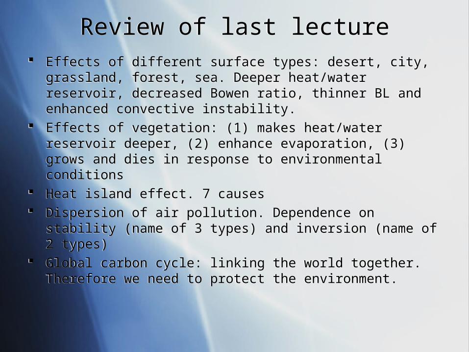
Review of last lectureReview of last lecture Effects of different surface types: desert, city, grassland, forest, sea.
Deeper heat/water reservoir, decreased Bowen ratio, thinner BL and enhanced convective instability.
Effects of vegetation: (1) makes heat/water reservoir deeper, (2) enhance evaporation, (3) grows and dies in response to environmental conditions
Heat island effect. 7 causes Dispersion of air pollution. Dependence on stability (name of 3 types) and
inversion (name of 2 types) Global carbon cycle: linking the world together. Therefore we need to
protect the environment.
Effects of different surface types: desert, city, grassland, forest, sea. Deeper heat/water reservoir, decreased Bowen ratio, thinner BL and enhanced convective instability.
Effects of vegetation: (1) makes heat/water reservoir deeper, (2) enhance evaporation, (3) grows and dies in response to environmental conditions
Heat island effect. 7 causes Dispersion of air pollution. Dependence on stability (name of 3 types) and
inversion (name of 2 types) Global carbon cycle: linking the world together. Therefore we need to
protect the environment.
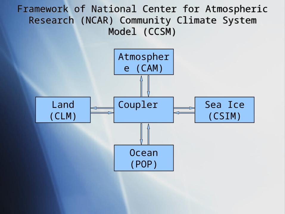
Coupler .
Land (CLM)
Sea Ice (CSIM)
Atmosphere (CAM)
Ocean (POP)
Framework of National Center for Atmospheric Research (NCAR) Community Climate System Model (CCSM)
Framework of National Center for Atmospheric Research (NCAR) Community Climate System Model (CCSM)
Community Land Model (CLM) Design PhilosophyCommunity Land Model (CLM) Design Philosophy
The model is designed to run in three different configurations:
1. Stand-alone executable code as part of the Community Climate System Model (CCSM).
2. A subroutine call within the Community Atmosphere Model (CAM) in which CAM/CLM represent single executable code.
3. Stand-alone executable code in which the model is forced with atmospheric datasets. In this mode, the model runs on a spatial grid that can range from one point to global.
CLM Model ComponentsCLM Model Components
• Biogeophysics • Hydrologic cycle• Biogeochemistry • Dynamic vegetation

CLM Model Components: BiogeophysicsCLM Model Components: Biogeophysics
QuickTime™ and a decompressor
are needed to see this picture.
CLM Model Components: Hydrological Cycle ICLM Model Components: Hydrological Cycle I
QuickTime™ and a decompressor
are needed to see this picture.
CLM Model Components: Hydrological Cycle IICLM Model Components: Hydrological Cycle II
QuickTime™ and a decompressor
are needed to see this picture.
CLM Water balanceCLM Water balance
QuickTime™ and a decompressor
are needed to see this picture.
QuickTime™ and aTIFF (Uncompressed) decompressor
are needed to see this picture.
QuickTime™ and aTIFF (Uncompressed) decompressor
are needed to see this picture.QuickTime™ and a
TIFF (Uncompressed) decompressorare needed to see this picture.
QuickTime™ and aTIFF (Uncompressed) decompressor
are needed to see this picture.

River Systems Simulated by CLMRiver Systems Simulated by CLM
QuickTime™ and aTIFF (Uncompressed) decompressor
are needed to see this picture.
Dai, Qian, Trenberth and Milliman (2009), J. Climate

CLM Model Components: Biogeochemistry CLM Model Components: Biogeochemistry
QuickTime™ and a decompressor
are needed to see this picture.

CLM Model Components: Dynamic Vegetation CLM Model Components: Dynamic Vegetation
QuickTime™ and a decompressor
are needed to see this picture.
DGVM Vegetation biogeography vs. SatelliteDGVM Vegetation biogeography vs. Satellite
QuickTime™ and a decompressor
are needed to see this picture.

Processes simulated in CLM3Processes simulated in CLM3
• Vegetation composition, structure, and phenology • Absorption, reflection, and transmittance of solar radiation• Absorption and emission of longwave radiation• Momentum, sensible heat (ground and canopy), and latent heat (ground evaporation, canopy evaporation, transpiration) fluxes• Heat transfer in soil and snow including phase change • Canopy hydrology (interception, throughfall, and drip) • Snow hydrology (snow accumulation and melt, compaction, water
transfer between snow layers)• Soil hydrology (surface runoff, infiltration, sub-surface drainage,
redistribution of water within the column)• Stomatal physiology and photosynthesis • Lake temperatures and fluxes• Routing of runoff from rivers to ocean• Volatile organic compounds
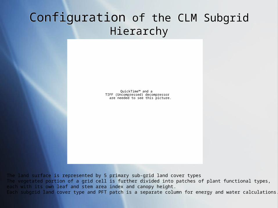
Configuration of the CLM Subgrid HierarchyConfiguration of the CLM Subgrid Hierarchy
QuickTime™ and aTIFF (Uncompressed) decompressor
are needed to see this picture.
The land surface is represented by 5 primary sub-grid land cover types The vegetated portion of a grid cell is further divided into patches of plant functional types, each with its own leaf and stem area index and canopy height.Each subgrid land cover type and PFT patch is a separate column for energy and water calculations.

Plant Functional TypesPlant Functional Types
QuickTime™ and aTIFF (Uncompressed) decompressor
are needed to see this picture.

How processes are simulatedHow processes are simulated
Biogeophysical processes are simulated foreach subgrid landunit, column, and PFT independently and each subgrid unit maintains its own prognostic variables.
The grid-average atmospheric forcing is used to force all subgrid unit within a grid cell.
The surface variables and fluxes required by the atmosphere are obtained by averaging the subgrid quantities weighted by their fractional areas.