Land Journal December 2015-January 2016
28
Land Journal A new dimension Valuation opens fresh opportunities for BIM PG. 20 Citizen housing Homes anger inspires Community Land Trusts PG. 17 Keeping it simple RICS takes a more informal approach to rural arbitration PG. 8 December 2015 / January 2016 rics.org/journals Will buyers pay more for homes in well designed places? PG. 6 Know your place
description
How many of you would expect to find Winston Churchill quoted in the journal. And not just a passing quote from one of his magnificent war speeches but an analysis of land value and development as part of a political debate on land speculation, housing and taxation. Churchill proclaimed in his 1909 election pamphlet: “The best way to make private property secure and respected is to bring the processes by which it is gained into harmony with the general interests of the public.” As Stephen Hill points out in his thought-provoking article on his research into affordable housing and Community Land Trusts, the debate over how to achieve this is just as relevant today. Churchill’s views on wealth creation by “plunder” as opposed to “productivity” may surprise many. The lead article covers another aspect of housing: whether buyers will pay more for for homes in well-designed places. RICS research on five examples suggests that they will and makes an interesting contribution to the debate.
Transcript of Land Journal December 2015-January 2016

RICS LAND JOURNAL
ST R A P L I N E
2 5 M A R C H /A P R I L 2 0 1 4 Images ©
Author AuthorStandfirst
Head
T
Land Journal
A new dimensionValuation opens fresh opportunities for BIM
PG. 20
Citizen housingHomes anger inspires Community Land Trusts
PG. 17
Keeping it simpleRICS takes a more informal approach to rural arbitration
PG. 8
December 2015 / January 2016
rics.org/journals
Will buyers pay more for homesin well designed places?
PG. 6
Know your place

This year, our Land Quality Endorsement service marks its 10th anniversary and has contributed to the restoration of over 100 sites with the potential for over 45,000 new homes.
Over this period our dedicated team of geo-environmental and geotechnical engineers have assessed some of the most contaminated and challenging sites in the UK; supporting the land development sector in preparing contaminated and marginal brownfield sites for sustainable residential end use and acceptability for Buildmark Warranty.
100+site restorations
45,000potential new homes can be built
To see how we could help you...Call us now on 0844 633 1000 and ask for LQE or visit www.nhbc.co.uk/lqe
J496 11/15
10Y
EA
RS
2005 - 2015A decade of raising standards in land quality

RICS LANDJOURNAL
While every reasonable effort has been made to ensure the accuracy of all content in the journal, RICS will have no responsibility for any errors or omissions in the content. The views expressed in the journal are not necessarily those of RICS. RICS cannot accept any liability for any loss or damage suffered by any person as a result of the content and the opinions expressed in the journal, or by any person acting or refraining to act as a result of the material included in the journal. All rights in the journal, including full copyright or publishing right, content and design, are owned by RICS, except where otherwise described. Any dispute arising out of the journal is subject to the law and jurisdiction of England and Wales. Crown copyright material is reproduced under the Open Government Licence v1.0 for public sector information: www.nationalarchives.gov.uk/doc/open-government-licence
contentsCONTACTS
D E C E M B E R 2 0 1 5 / J A N U A R Y 2 0 1 6 3
RICS LAND JOURNAL
ST R A P L I N E
2 4 M A R C H /A P R I L 2 0 1 4 Images ©
Author AuthorStandfirst
Head
T
Land Journal
A new dimensionValuation opens fresh opportunities for BIM
PG. 20
Citizen housingHomes anger inspires Community Land Trusts
PG. 17
Keeping it simpleRICS takes a more informal approach to rural arbitration
PG. 8
December 2015 / January 2016
rics.org/journals
Will buyers pay more for homesin well designed places?
PG. 6
Know your place
Front cover: ©Shutterstock
LAND JOURNAL
Editor: Mike Swain T +44 (0)20 7695 1595 E [email protected]
Editorial team: James Kavanagh, Fiona Mannix, Tony Mulhall (Land Group)
Land Journal is the journal of the Environment, Geomatics, Minerals and Waste, Planning and Development and Rural Professional Groups
Advisory group: Tim Andrews (Stephenson Harwood LLP), Philip Leverton (College of Estate Management), Rob Yorke (rural chartered surveyor), Michael Rocks (Michael Rocks Surveying), Tim Woodward (rural chartered surveyor), Michael Birnie (Buccleuch Estates), Marion Payne-Bird (consultant), Frances Plimmer (FIG – The International Federation of Surveyors), Duncan Moss (Ordnance Survey), Kevin Biggs (Royal Bank of Scotland)
The Land Journal is available on annual subscription. All enquiries from non-RICS members for institutional or company subscriptions should be directed to: Proquest – Online Institutional Access E [email protected] T +44 (0)1223 215512 for online subscriptions or SWETS Print Institutional Access E [email protected] T +44 (0)1235 857500 for print subscriptions
To take out a personal subscription, members and non-members should contact Licensing Manager Louise Weale E [email protected]
Published by: Royal Institution of Chartered Surveyors, Parliament Square, London SW1P 3AD T +44 (0)24 7686 8555 www.rics.org ISSN: ISSN 1754-9094 (Print) ISSN 1754-9108 (Online)
Editorial and production manager: Toni Gill
Sub-editor: Gill Rastall
Designer: Nicola Skowronek
Creative director: Mark Parry
Advertising: Emma Kennedy T +44(0)20 7871 5734 E [email protected]
Design by: Redactive Media Group Printed by: Page Bros
C O N T E N TS
4 From the chairmen
5Update
6Know your placeChris Crook explores the link between good design and value in five new homes case studies
8Keeping it simpleA new arbitration service for the rural sector is explained by Martin Burns
10Who owns our land?Mike Taylor reports on the background and developments in land ownership across Europe
12Protecting your options Agreement terms should be carefully considered when taking options on land acquisition, explains Kirsten Dunlop
14Fair sharesMichelle Bendall reviews the implications of recent court decisions involving overage
17An alternative approachStephen Hill says citizen-inspired Community Land Trusts are a visible sign of the public’s frustration with the market and affordable housing policies
20A new dimension Sara Wilkinson reports on RICS research exploring the ‘value dimension’ in building information models
22A handy deviceJoe Croser explains how a hand-held laser scanner can save time and money on measured building surveys
24Testing the theoryChristopher Barlow looks at the benefits of building modern property and land valuation systems for developing countries

FROM THE CHAIRMEN
C H A I R M E N ’S C O L U M NRICS LANDJOURNAL
4 D E C E M B E R 2 0 1 5 / J A N U A R Y 2 0 1 6
Barney Pilgrim FRICS
LAND & RESOURCES GLOBAL BOARD
The board has continued to grow – adding not only Oceania but now Asia/Pacific members and meeting in London. The group infographic is
October saw the launch of the Fresh Start Land Enterprise Centre at the House of Lords. RICS is a partner with other key stakeholder bodies and has also been engaged with the publication of The Land partnerships handbook: using land to unlock business innovation, which I recommend (http://bit.ly/1XPpU6C).
Also in October, an unprecedented partnership of farming groups launched a new network, Innovative Farmers, which RICS attended. This key initiative gives farmers a role in shaping priorities for funding, recognising that many of the best ideas come directly from them (www.soilassociation.org/fieldlabs).
The Department for Environment, Food and Rural Affairs is developing a 25-year Food and Farming Plan to make British food and farming a world leader. RICS attended the launch and participated in the workshops. The plan focuses on barriers to growth, exports and branding, investment, productivity, risk management and procurement. While there is some scepticism over such a long time frame, the themes are relevant and success in agricultural enterprises will depend on managing them.
RURAL
John LockhartFRICS
I will be stepping down as chair of RICS Geomatics after three years at the end of 2015. Even though the group also provides Geomatics world (www.pvpubs.com) to our members, we have always been very supportive of the integrated and holistic nature and content of the Land Journal. This content really does provide a platform for the future development of the ‘land professional’ and the bringing together of several sectors under the banner.
This issue features an article on the ground-breaking Zeb 1 hand-held scanner which should interest all those who measure. BIM is also featured in a way not previously investigated. BIM and value
GEOMATICS
ChrisPreston FRICS
In the October/November journal, I made the case for the Land & Resources Group and the rest of the profession to consider developing a competency in aspects of ‘geography’. My next suggestion is to consider one in being ‘visually literate’ as regards the natural and built environment.
If we are to carry out our professional functions and responsibilities in a competent manner, we need to understand and interpret what we are looking at to a sufficient level. Then we need to articulate what we see. One exercise I have tried with students is to give them a picture of a building and ask them to describe it to someone who cannot view it: it’s not easy.
While there is a level of subjectivity, the act of ‘surveying’ implies looking at something with a purpose: a measure, an evaluation or a judgment. I accept that this skill is implicitly inherent in many of the competencies, but it might be purposeful to signpost and have a visually explicit competency to at least level 1 or 2. For example, given that much redevelopment occurs in the centres of historic towns and cities, understanding and crucially ‘seeing’ proportion, massing, scale and volume in an architectural sense is critical in optimising development potential, yet acknowledging context.
On the matter of basic competencies, while P&D applicants, like many other pathways, have to have a level 1 core competency in the measurement of land and property, management consultancy does not. This is something that needs review, especially as the International Property Measurement Standards for Office Buildings becomes mandatory for all RICS members from January 2016: Est Modus in Rebus?
PLANNING & DEVELOPMENT
Paul CollinsMRICS
near completion and we also intend to develop a YouTube video (much like the RICS Futures, www.rics.org/futures).
Another major development has been the establishment of the International Land Measurement Standard (ILMS) coalition with an initial group of eight major professional bodies. We are expecting the coalition to set up specific expert standards settings committees and governance structures in 2016.
The underlying narrative is simple but compelling — to reduce the risk in internal or external land investment by establishing a ‘benchmark’ listing of essential land reporting elements that can be used anywhere in the world. The increasing pressures on society and the environment (highlighted by the December 2015 UN COP21 climate change conference in Paris) needs to be dealt with by agreed international standards such as ILMS, International Ethics Standards and International Construction Measurement Standards.
D E C E M B E R 2 0 1 5 / J A N U A R Y 2 0 1 6 5
UPDATE
U P DAT E RICS LAND JOURNAL
Our conference in Bristol was attended by more than 100 delegates who appreciated some excellent papers and a very good questions session. I am hopeful that we will see some of the papers converted into articles for the journal.
The board wants you to assist in making these conferences better, so please put your ideas to the board or RICS Events. The next conference will be at Eastwood Hall, Nottingham, on 14 April 2016, so let me know of any topics you have for the agenda.
The global consultation for the Mineral bearing land and waste management sites guidance note has finished. RICS is now collating comments for the working group and we hope this note will be published in early 2016.
The Governing Council has approved project PG 2020, which is looking at digital technology for use by RICS members, probably Yammer — a platform like Twitter — and LinkedIn. This project will present a real opportunity to engage directly with professional groups to produce and consult on our content as well as the wider RICS. A pilot system will be investigated to learn more about our requirements and also to test the technology.
ENVIRONMENT & RESOURCES
AndrewFitzherbert MRICS
is a little understood but important future issue during the property life cycle by those generally thought of as outside the construction process.
Finally, a piece from Cape Town further underlines the important synergy between valuation and the formalisation and establishment of effective land and property rights – a key goal of a major RICS Research study for 2016. Finally, do keep an eye on the ongoing geo evening lecture series (http://bit.ly1Q5c7sw).
The NHBC Land Quality Endorsement service is celebrating its 10th anniversary. During the past decade the team has assessed some of the most contaminated and challenging residential sites in the UK including landfills, quarries, gas works, collieries, open case mining works and chemical and industrial complexes.
The team delivers technical risk management and guidance for land developers and landowners looking to undertake remediation or reclamation of brownfield or marginal sites for residential development. The team has
Rural Conference Wales 9 December, The Metropole Hotel, Llandrindod Wellsn www.rics.org/walesrural
Rural Conference South East2 February 2016, The Spa Hotel, Royal Tunbridge Wells n www.rics.org/southeastrural
RICS CPD days Regional conference programme focused on key developments
8 March, Holywell Park, Loughborough Universityn www.rics.org/eastmidlandscpd 17 March, Cymru, Llandudnon www.rics.org/northwalescpd
Two collections of case summaries have been issued by Harper Adams University. Negligent valuation casebook: key cases from the 19th to the 21st centuries covers the key points surrounding valuation litigation: the law of negligence and professional negligence, permitted claimants — to whom do valuers owe a duty of care?, reasonable care — what is expected of a valuer, margin of error across property types, measure of damages, expert witness matters.
The second, Health and safety casebook: key cases from 1837 to 2015, has particular reference to the land-based industries. It embraces
both civil and criminal liability for accidents in the workplace. Areas covered include Health and Safety at Work etc. Act 1974, corporate manslaughter, Factories Act 1961, Animals Act 1971, Management of Health and Safety at Work Regulations, Control of Substances Hazardous to Health Regulations, negligence, nuisance, occupiers' liability, employment contracts and more. n Both collections can be viewed at http://bit.ly/1MOPqFB and will be updated periodically. Comments and suggestions should be sent to [email protected]
Land Quality team turns 10
Casebook collections
contributed to the restoration of more than 100 sites, with the potential for 45,000 new homes.
For Buildmark warranty cover on new homes, land developers need to ensure that the requirements of NHBC’s standards on land quality are satisfied.
On completion of the land remediation, a Certificate of Land Quality Endorsement is provided by NHBC to the land developer, detailing the works undertaken and identifying the remaining land quality criteria that must be fulfilled prior to, or during, housebuilding.n Visit www.nhbc.co.uk/lqe
In brief...

RICS LAND JOURNAL
6 D E C E M B E R 2 0 1 5 / J A N U A R Y 2 0 1 6
D E V E LO P M E N T
Know your placeChris Crook explores the link between good design and value in five new homes case studies
What are those characteristics of buildings and developments that contribute financial value? RICS commissioned
property consultants CBRE to research the link between good placemaking and value. The initial message is that if developers create places that are well planned, designed and built, people are prepared to pay more for homes there.
Good placemaking is about vision, tenacity and standards. It relies on the skills of planners, urban designers, architects, engineers and surveyors. It is also about land management and economics, finance, sales and marketing. Most of all, it is about community participation and politics.
MethodThe five residential case studies varied in size, phasing, progress, location and market conditions. Three are extensions to settlements formerly designated as new towns. All were distinctx residential neighbourhoods or districts that had an equal opportunity to create a positive sense of place and a cohesive new community.
b Newhall, Harlow, Essex b Upton, Northampton, Northamptonshire b Hampton, Peterborough, b Accordia, Cambridge b Kings Hill, West Malling.
A number of elements were used to evaluate successful placemaking:
b the development team b clarity of vision b quality of architecture and design b layout b commercial and community provision b public and private amenity space b transport, car parking, accessibility
and walkability b effective community engagement b sustainability.
Land Registry data accurately reflected how schemes have sold in relation to local market conditions. Possible connections
new build housing when sold as new. Upton, the weakest performer, exceeded average local new build values by 25%, while Accordia, the strongest, gained 56%.
LayoutMany case studies followed a similar layout and street pattern. There is typically a core from which main tributary roads spring, interspersed with groups of dense housing. The layout feels less formal and implicitly ‘organic’, even though it has usually been conceived by masterplanners. It is supported by the height of the buildings, and landscaping of the roads. The consistency suggests some unanimity about how to achieve the placemaking goals of planning that satisfy commercial requirements.
Phasing Although critical to creating a sense of place, phasing of commercial and community buildings inevitably proves difficult. The lack of provision is probably the most common complaint among pioneer residents and is still common on schemes that should already be well established. This undermines confidence and encourages car dependency.
The most successful examples in the case studies have been where flexible space has been provided. Kings Hill offered offices to early residents as a meeting place, which helped the parish council to engage with the landowners and developers.
Some schemes have built a large supermarket in the centre, such as Kings Hill. Supermarkets are often ‘outward facing’, due to the car parking
between successful placemaking factors and the values achieved on these sites were then explored.
The performance of each case study in their local market and against the national average for house prices are shown in Figures 1 to 3. The findings demonstrate positive relationships between placemaking and commercial value. However, a considerable disparity in the size of the premium was revealed, as well as in relation to the typology of the unit.
Existing Tonbridge-Malling and Cambridge properties significantly exceed the England and Wales average and the values in the developments at Kingshill and Accordia further exceed these local averages. Where values are already high and demand is strong, good placemaking would seem to further enhance values. The exception is Newhall, Harlow. Of the cases in areas below the national average, Newhall has succeeded in outperforming local area values.
Key lessons Figure 2 indicates that good placemaking enables housing in the case studies to achieve values in excess of other local
Average house values (£) compared with national average 2013
Figure 1
“Where demand is strong, good placemaking would seem to further enhance values
600,000500,000400,000300,000200,000100,000
England
Northam
pton
Upton
Peterb
orough
Hampto
nHarlo
wNewhall
Tonbrid
geKin
gshill
Cambrid
geAccord
ia
0

RICS LAND JOURNAL
D E C E M B E R 2 0 1 5 / J A N U A R Y 2 0 1 6 7
provision, but ideally would integrate with residential. This is difficult to correct later.
Green spaceThis has been the most prominent community offering. It sets an aesthetically pleasing tone to the development, which creates an ideal shop window and gives pioneer residents confidence. The use of open space balances the high-density levels; rather than larger rear and front gardens, the preference has been for usable space that residents can enjoy. Natural amenities, across all the case studies, allow developers to promote sustainable living.
SustainabilityThe intentions were more obvious at some schemes than others. Upton emphasised sustainability through extensive sustainable drainage schemes, as well as the design of the housing. Of particular note was the Metropolitan Housing Scheme, with its experimental eco-houses. Although substantial premiums may not have been achieved, these types of endeavour arguably benefit the industry through innovation and education.
Architecture and design The choice of architecture on new settlements is inevitably subjective. It is essential that it is in line with local market and buyer expectations. Newhall’s contemporary architecture may not suit a location where demand is for traditional homes. Similarly, a neo-traditional development might not suit Harlow. However, in Harlow, where there has been a dearth of new development, the architecture stood out as creative and confident. Similarly, Accordia was a creative departure from the local traditional architectural landscape.
The convincing quality of both the design and materials meant that it was highly regarded both by architects and
housebuyers. The architectural standard at these case studies creates a high quality of development. Design codes, which allowed some degree of flexibility, have generally proved successful. They help to create consistency, and with the landowner and planners on board, offer housebuilders sites with much less risk.
LeadershipThe forms of leadership ranged from a hands-on landowner to a detailed masterplan with prescriptive design codes, or to a collaborative exercise. The latter, at Upton, could not respond easily to changing needs and external conditions. The most successful leaderships have been by Liberty Property Trust (LPT) at Kings Hill and O&H Properties at Hampton.
LPT has engaged with residents, instilling a strong sense of ownership. Hampton residents have been slower to take responsibility, but O&H has played a pivotal role in creating a sense of community.
Enhancing valueThe value analysis revealed that on the most successful schemes in placemaking terms the cheaper family housing achieved the highest premiums. This suggests that young families are willing to pay a premium for these sorts of developments even if they have to compromise on the size of the property.
Terraced properties were sometimes more expensive than local semi-detached properties. Schools play a major role, as Hampton illustrates, but sometimes people simply want to be a part of this sort of community. Newhall concentrated development on terraced properties.
The market for larger executive homes is more open, with more affluent families often preferring a traditional house in a rural area with more space. The detached properties at Upton bucked the trends by
outperforming the local market, reflecting the architecture and configuration of these homes.
The greatest re-sales uplift has been at Accordia, whose reputation has grown considerably since its original conception, illustrating the long-term potential of creating a strong sense of place. Most of these settlements would benefit from a greater range in dwelling types and pricing. Smaller and more affordable units at Kings Hill would provide accommodation for the elderly, divorcees and first time buyers. This is key to maintaining and growing the local population.
Pioneer residents typically purchase at a slight discount; at Hampton this was around 10% below local market value. At Accordia, the early sales were key to setting good pricing later. This is likely to be easier on a smaller scheme.
ConclusionAt a time of acute housing shortage, there is a temptation to focus on the numbers of dwelling units built rather than the quality of the places being created. The findings have shown that with clear vision, strong leadership and a creative team, placemaking can achieve enhanced value. But it does require patience, dedication to high standards and the capital resources to think and act with a long-term perspective. C
Chris Crook is Chair of the RICS Placemaking and Value working group [email protected]
Related competencies include Development appraisals, Planning, Legal/regulatory compliance, Valuation, Housing strategy and provision, Sustainability
Case studies compound annual growth rate
Figure 3Average newbuild comparison 2013
Figure 2
Source: CBRE/Land Registry
600,000500,000
8%
6%
4%
2%
0%
-2%-4%-6%-8%
400,000300,000
100,000200,000
England/
Wale
s
Northam
pton
Northam
pton
Upton Upto
n
Other n
ew
Peterb
orough
Peterb
orough
Hampto
n
Hampto
n
Other n
ewHarlo
w
Harlow
Newhall
Newhall
Other n
ew
Tonbrid
ge Malli
ng
Tonbrid
ge Malli
ng
Kingsh
ill
Kingsh
ill
Other n
ewCam
bridge
Cambrid
ge
Accordia
Accordia
Other n
ew
0
RICS LANDJOURNAL
8 D E C E M B E R 2 0 1 5 / J A N U A R Y 2 0 1 6
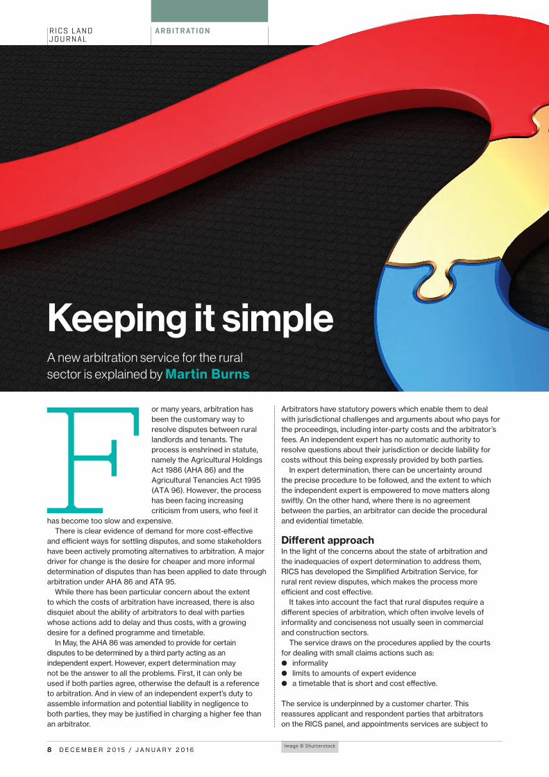
A R B I T R AT I O N
Image © Shutterstock
A new arbitration service for the rural sector is explained by Martin Burns
Keeping it simple
F or many years, arbitration has been the customary way to resolve disputes between rural landlords and tenants. The process is enshrined in statute, namely the Agricultural Holdings Act 1986 (AHA 86) and the Agricultural Tenancies Act 1995 (ATA 96). However, the process has been facing increasing criticism from users, who feel it
has become too slow and expensive. There is clear evidence of demand for more cost-effective
and efficient ways for settling disputes, and some stakeholders have been actively promoting alternatives to arbitration. A major driver for change is the desire for cheaper and more informal determination of disputes than has been applied to date through arbitration under AHA 86 and ATA 95.
While there has been particular concern about the extent to which the costs of arbitration have increased, there is also disquiet about the ability of arbitrators to deal with parties whose actions add to delay and thus costs, with a growing desire for a defined programme and timetable.
In May, the AHA 86 was amended to provide for certain disputes to be determined by a third party acting as an independent expert. However, expert determination may not be the answer to all the problems. First, it can only be used if both parties agree, otherwise the default is a reference to arbitration. And in view of an independent expert’s duty to assemble information and potential liability in negligence to both parties, they may be justified in charging a higher fee than an arbitrator.
Arbitrators have statutory powers which enable them to deal with jurisdictional challenges and arguments about who pays for the proceedings, including inter-party costs and the arbitrator’s fees. An independent expert has no automatic authority to resolve questions about their jurisdiction or decide liability for costs without this being expressly provided by both parties.
In expert determination, there can be uncertainty around the precise procedure to be followed, and the extent to which the independent expert is empowered to move matters along swiftly. On the other hand, where there is no agreement between the parties, an arbitrator can decide the procedural and evidential timetable.
Different approachIn the light of the concerns about the state of arbitration and the inadequacies of expert determination to address them, RICS has developed the Simplified Arbitration Service, for rural rent review disputes, which makes the process more efficient and cost effective.
It takes into account the fact that rural disputes require a different species of arbitration, which often involve levels of informality and conciseness not usually seen in commercial and construction sectors.
The service draws on the procedures applied by the courts for dealing with small claims actions such as:
b informality b limits to amounts of expert evidence b a timetable that is short and cost effective.
The service is underpinned by a customer charter. This reassures applicant and respondent parties that arbitrators on the RICS panel, and appointments services are subject to

The purpose“
RICS LANDJOURNAL
D E C E M B E R 2 0 1 5 / J A N U A R Y 2 0 1 6 9
service level agreements. These include customer orientated performance targets, and that compliance is monitored by an independent governance board.
The purpose is to engender confidence by explaining the procedures for panel recruitment, retention and removal. It also gives a commitment that panels are comprised of high quality and experienced practitioners who will strive to adapt to individual circumstances and ensure disputes are resolved as quickly and informally as possible.
More information>
For details of the Simplified Arbitration Service, email Samantha Dunbar at [email protected]
Related competencies include Conflict avoidance, management and dispute resolution proceduresMartin Burns is RICS Head of ADR Research and Development
How it works The Simplified Arbitration Service enables parties to jointly opt for a procedure that is quick, transparent, even handed and inexpensive.
1 The parties agree to abide by the procedural rules published by RICS.
2 An arbitrator is appointed by RICS and undertakes the process in accordance with the procedural rules.
3 The arbitrator:• receives and considers written submissions from
both parties (including statements of case and skeleton arguments, rebuttal, lists of comparables, lists of agreed and non-agreed facts) • undertakes a site visit • holds a meeting/hearing with both parties.
4 A decision will be made by the arbitrator on whether there is any need for expert evidence. (The default
position is that there will be no expert evidence or, if expert evidence is required by the arbitrator, such evidence will be limited).
5 Any expert(s) attending the meeting/hearing are examined by the arbitrator. (There is no process of
examination and cross-examination).
6The arbitrator publishes the decision within 10 working days following completion of the hearing/meeting, or such
longer period agreed by the parties.
7The substantive process should cover no more than three working days. In any case, the arbitrator only
charges for three days work at £1,000 per day (+VAT) as long as the parties abide by the Simplified Arbitration Service rules and any directions made by the arbitrator.
8 The costs of the arbitration are shared equally by the parties (i.e. £1,500 per party).

Images © iStock
RICS LAND JOURNAL
1 0 D E C E M B E R 2 0 1 5 / J A N U A R Y 2 0 1 6
AG R I C U LT U R A L L A N D
TThe UK farming area is approximately 17.2 million hectares, made up of roughly 212,000 farming units, or holdings, each with an average size of 77ha and receiving an average of £13,500 in EU support.
In England, there are just over nine million hectares of farmland, 30% of which is occupied on tenancies or leases of one year or more and some 60% on secure tenancies under the Agricultural Holdings Act 1986. However in Scotland, where farmland area extends to around 5.8 million hectares, tenanted land makes up only 24%.
Around 70% of the UK land area is actively farmed either as arable or pasture land. This is one of the highest proportions in Europe, with Norway at the bottom end with a mere 3% and most of the larger nations at around 50%, largely due to a relatively low level of afforestation (10%) and limited mountainous terrain.
The strong pound and weak global commodity prices have been causing considerable
Attractive investmentA number of fiscal attractions exist to land ownership as an investment within the UK. Agricultural land and buildings are largely free from inheritance tax and farmland and buildings used as part of a business can obtain significant relief from capital gains tax.
Average farm land values in England and Wales have risen from around £4,000 per acre (£9,885/ha) in 2005 to £10,000 per acre (£25,000/ha) by the second quarter of 2014. Real estate agents report no let-up in prices yet, with the best arable land selling close to £15,000 per acre (£37,000/ha).
The RICS and RAU combined Survey and farmland directory of land prices provides a detailed national database of comparable farm land sales
downward pressure on UK farm incomes. The plight of the dairy farmers has been well publicised due mainly to China’s withdrawal from the European milk market. A bumper harvest is further depressing the cereal market which was already moving backwards.
Farming has long been recognised as being in counter cycle to the rest of the economy and this is now taking its toll on the industry as the country begins to emerge from recession.
There are no nationally collated figures available for foreign investment in UK agricultural land and in England and Wales there is no firm government policy either for or against it, although the situation is somewhat different in Scotland.
Foreign buyersAnecdotal evidence from real estate agents and others suggests that the stable nature of the English and Welsh land market, combined with fiscal incentives, have encouraged both foreign buyers and UK-based investors.
Within the UK, investors may have moved out of other assets perceived as ‘risky’ to seek a ‘safe haven’ for their money, a trend that appears to have been accelerated by the 2008 recession and then continued. Inventor Sir James Dyson’s purchase of 25,000 acres (10,000ha) of English farmland over the past 10
years is a good example of a non-agricultural buyer.
It is important to note that all land in England and Wales is required to be registered at Her Majesty’s Land Registry following any significant change in title. However, this does not affect land that has not changed hands since registration was made compulsory and the Land Registry estimates that 20% of the land mass in England and Wales remains unregistered, most of it rural land. Accurate statistics on the identity of landowners and the nature of land holding in the UK are therefore very difficult to produce.
Research by Kevin Cahill in 2002 found that two thirds of UK land was owned by 189,000 families, but he could not account for 10% of the country’s land ownership. Amid fears that proceeds of foreign crime are being ‘laundered’ through the UK property market, Prime Minister David Cameron has called for more transparency and has announced proposals for the Land Registry to publish details of land held by foreign investment companies. The Financial Times has estimated that at least £122bn of property in England and Wales is owned by offshore companies and while most of this investment will be in commercial and residential property in London and the South East, some will be in agricultural property across the UK.
Mike Taylor reports on the background and developments in land ownership in Europe
Who owns our land?

RICS LAND JOURNAL
D E C E M B E R 2 0 1 5 / J A N U A R Y 2 0 1 6 1 1
Furthermore, neighbouring farmers are often entitled to a right of pre-emption.
Many states use their land registry as a management tool for taxation and land control and are consequently mystified by the UK approach. In Spain, for example, the introduction of a multi-layered online database includes not only land ownership details but also environmental factors, spatial planning matters and neighbouring land uses. This gives potential land buyers a wealth of freely available information before they make a decision. This could usefully be extended to the rest of Europe although data protection issues remain a concern.
In the closing session of the CEDR European agricultural law conference at Potsdam, Germany, Professor Rolan Norer of Lucerne University commented that a “common legal basis for Agricultural Law (in the EU) remains a dream” and went on to ask: “do we have only a common administrative and financial system, and actually are all member states doing their own thing and are not at all common”. Food for thought indeed. b
More information>
The author presented a paper on UK Land Ownership at the 2015 CEDR European Council for Rural Law Conference in Potsdam, Germany, on behalf of the UK Agricultural Law Association.
Who owns Britain by Kevin Cahill is published by Canongate Books.
to assist rural members involved in valuation.
These relatively high value levels are making it increasingly difficult for ordinary farmers to purchase additional land. However, many outside ‘investment’ buyers are not interested in farming and the land is often rented out on contract farming arrangements and share cropping agreements to allow the new owner to enjoy the fiscal benefits of being an ‘active farmer’ while leaving the responsibilities to those better skilled and equipped.
Unlike much of continental Europe, there is no regulation of foreign investment in UK real estate. Interestingly, there are restrictions on foreign acquisitions of companies operating in sensitive areas such as banking, financial services and utilities, although these are unlikely to directly affect agricultural real estate.
ScotlandIn Scotland, radical changes are proposed within the Land Reform Bill published on 22 June 2015. This has just completed its consultation period and recommended: “Limiting legal entities that can, in the future, take ownership of land in Scotland.”
More specifically, the Land Reform Review Group suggests limitation on non EU land ownership and furthermore the Bill proposes that Scottish Ministers can: “Intervene in situations where the scale or pattern of land ownership in an area, and the conduct of the owner, is acting as a barrier to sustainable development.”
The Scottish Land Reform Act 2003 began this process with a community right to buy when land came up for sale and a crofters community right to buy, which applies specifically to croft tenants.
Cahill suggests that just over 400 individuals own over half the land in private ownership in Scotland and the Bill has been met with outrage by landowners. It was reported by some farm agents that the initial effect had been to cause uncertainty in the Scottish land market, deterring foreign investors. However, the most radical reforms are now being moderated and it would seem that confidence has returned.
EuropeIn most of the rest of Europe, spatial planning (town and country planning) appears to be far less sophisticated and authorities rely much more heavily on restrictions on land ownership to influence the use of land and to protect rural communities.
This would seem to fly in the face of the Treaty of Rome, which requires free movement of capital and labour. However, national
and regional governments justify the controls by relying on Article 39 (1b), which sets out, among other objectives, to “ensure a fair standard of living for the agricultural community” and the social constraints identified in Article 39(2).
It seems that only Holland has an open land market similar to the UK, with all other EU countries controlling farmland ownership to a greater or lesser degree. This is understandable for new member states (NMS) in Eastern Europe, where land values remain low and there is concern about potential land grabs by individuals or companies from wealthier nations.
The NMS have enjoyed a derogation on land ownership controls to allow for transition but this has, or is about to expire. Complaints about double standards have been raised as old member states retain historical land controls. In Germany, for example, the Law on the Sale of Agricultural Land requires prior approval of all transfers, which can be rejected if the price is too high, the size of the transfer is not appropriate, or there is considered to be “unhealthy distribution”.
“There is no regulation of foreign investment in UK real estate
Related competencies include Investment management (including fund and portfolio management)
Mike Taylor is Senior Partner at Barbers Rural [email protected]

Image © Shutterstock
RICS LAND JOURNAL
1 2 D E C E M B E R 2 0 1 5 / J A N U A R Y 2 0 1 6
L A N D P U R C H AS I N G
Agreement terms should be carefully considered when taking options on land acquisition, cautions Kirsten Dunlop
Protecting your options
Options to purchase land are a good means of securing rights to buy, without commitment. They can be simple or complicated. An option
must be in writing and can be a deed or an agreement, provided that payment of an option fee is included.The advantage of an option rather than a conditional contract is that there is no obligation on the purchaser to exercise the option.
Options can be exercisable on a fixed date, but more usually during an agreed period triggered by a particular event. This is commonly the grant of a satisfactory planning consent after all reserved matters have been dealt with. The option period needs to be long enough to allow the developer sufficient time to carry out all necessary due diligence, which may include searches and surveys, environmental tests, finalising layout plans, and obtaining planning and other consents.
From a developer’s perspective, the period should be capable of being extended on more than one occasion. At a minimum, this should be at expiry, if a planning decision is outstanding, if other key consents remain, or if a challenge to planning or judicial review is in progress. The time for serving the option notice should not end until after the last appeal or judicial review has been decided.
Options are often used where a developer wants to acquire adjoining land to form one large site. It may suit to take the whole of a landowner’s title, provided the developer can elect later to acquire only the proportion necessary for the development. While this will mean paying a higher initial option fee, the purchase price will ultimately reflect the extent of land actually acquired, which gives the developer maximum flexibility.
of the land at a specific time (usually once satisfactory planning consent has been obtained). The price will be a percentage of that figure, less specified developer’s costs. It is common for the agreed purchase price to be stated in the notice, so it is crucial that the valuation method is clearly set out in the option agreement, including the assumptions and disregards.
Flawed valuation provisions may lead to landowners having to accept much lower purchase prices than they anticipated, or, for developers, can result in an unacceptable land value that renders the development unworkable. The option agreement should, therefore, include provisions setting out how
Restrictive planning Where the trigger event is the grant of a satisfactory planning consent, the developer can conclude its plans and due diligence before exercising the option. However, the agreement should also allow the developer flexibility to purchase without waiting for planning approval. This may be important if, for example, a rival developer becomes interested in the area, where the land includes a useful ransom strip or if there is a fixed longstop date that cannot be further extended.
An option to purchase that is exercisable on the grant of a specified planning consent should be avoided because it is too restrictive and could become worthless if plans for the site have to change following due diligence or required by the planning authority.
Landowners may want to include a longstop date to give certainty over when they will receive the purchase monies. They will also want to ensure that the developer cannot exercise the option to purchase a large area of land but then only build a small development in the first instance, with the intention of avoiding overage payments and then later extending the development.
For this reason, the landowner may include a minimum planning description to confirm the size and/or composition of the development (e.g. primarily residential comprising not less than 40, two-bed units with retail/commercial elements).
Inclusion of a longstop date and a minimum planning description can be acceptable to a developer provided that satisfactory planning consent is defined from its own perspective and not objectively.
Purchase priceThe option agreement will refer to a fixed purchase price or include a method for establishing the open market value

RICS LAND JOURNAL
D E C E M B E R 2 0 1 5 / J A N U A R Y 2 0 1 6 1 3
disputes, as to value or validity, will be resolved.
Serving the noticeThe option notice must be drafted strictly in accordance with the terms of the agreement to avoid any argument as to invalid service. It is important, therefore, that the agreement is clear on its requirements. For example, it should not state that the deposit monies be paid on the same day as the notice is served, because if the bank transfer fails, the option will be invalid.
Overage If land will only achieve its maximum potential value following a certain event
(such as grant of planning), the landowner will want to include overage provisions in the agreement to ensure they get a share of the increased value at that later date.
An example would be where the agreed purchase price is reduced to factor in the developer’s additional costs for remediating polluted land. The option agreement can include provisions requiring a final accounting of the costs and profits, so that if the eventual value is higher than the baseline value, the landowner will receive an additional payment at practical completion, or at a specified time after that date.
Rights to overage can be secured by imposing a charge, guarantee or bond, or registering a positive or restrictive
covenant on the land. An alternative is for the landowner to be granted a reverse option, giving it a right to buy back the land if the developer fails to pay the overage when due.
Protecting the optionIf land is registered, the option should be an agreed or unilateral notice and a restriction entered on the title at the Land Registry. For unregistered land, the option agreement should be registered as a class (iv) land charge at the Land Charges Register. Failure to do so means a third party could acquire the land free of the option.
Stamp duty land tax SDLT may be payable on the grant of an option depending on the amount of the fee. If the agreement contains reference to future unascertainable overage payments then SDLT is payable on an estimated purchase price, adjusted if the final agreed price is higher or lower. Alternatively, a developer can apply to defer payment of SDLT if the final figure will not be known for at least six months.
Land options will continue to be a useful tool for strategic acquisitions provided the proper advice is taken and the agreement terms ensure the developer does not waste both time and money. b
It is crucial to ensure that the valuation method is clearly set out in the option agreement
Related competencies include Valuation, Legal/regulatory compliance, Purchase and sale
Kirsten Dunlop is a Senior Associate in the real estate team at law firm Winckworth Sherwood [email protected]

RICS LAND JOURNAL
1 4 D E C E M B E R 2 0 1 5 / J A N U A R Y 2 0 1 6
D E V E LO P M E N T
Avoiding getting embroiled in a dispute is difficult in the area of overage because there will always be a divergence of opinion when the agreement comes to be implemented, no matter how good the drafting. The developer (payer of the overage) will want to minimise the sum and the seller (the receiver of the payment) will want to maximise the amount being paid out. The scene is set for conflict and litigation.
The first issue is whether an overage provision is the best way to deal with any hope value in the land. If the land is miles away from where the seller is located, if the site
C Cases on overage clauses offer valuable lessons both in terms of negotiating agreements and drafting documents. They also demonstrate how the courts will look at interpreting documents, implying terms and considering mistakes and rectification.
is small and there is a very remote prospect of a development taking place, who will police the site to see if there have been any breaches? Is it worth spending the time and money?
The second point, which will also seem obvious to anyone who has been involved in an overage dispute, is that the professionals working on an agreement must see it as a multi-disciplinary matter.
The full attention of clients, surveyors and lawyers is required at negotiation and drafting stage to ensure that the parties have a fair chance of avoiding a dispute in the future. Worked examples
should be run on the wording used and kept with the legal documentation.
Much of the litigation surrounding overage clauses is pursued on the basis that one of the parties wants to imply a term into a contract or that there should be a rectification because one or both parties have made a mistake.
If the court is looking at interpretation and implied terms, there is a limit to the background documentation that can be placed before the court. The court will usually look at the document and draw conclusions from it.
Image © iStock
Michelle Bendall reviews the implications of recent court decisions involving overage
Fair shares

RICS LAND JOURNAL
An implied term can be introduced into a contract if it is clear that it is necessary for it to be there and if it is so obvious that it goes without saying.
For example, in Renewal Leeds Ltd v Lowry Properties Ltd [2010] the seller sold land to a developer under an agreement that was conditional on planning and under which an overage
payment of 50% of the total sale revenue became due if the figure exceeded £7.4m. This payment was triggered by the sale of all completed residential units.
Planning permission was granted for 84 houses, and 80 were sold for revenues of £9.6m. The remaining four houses, however continued to be marketed at prices at least £34,000 above the market
value and remained unsold despite the seller's offer to buy them. The original agreement contained no obligation on the developer to build or sell any units.
Here, the trigger was lacking. There should have been a provision requiring the developer to sell the units.
More often than not the court will not imply a term. Luckily for the seller, in this case the court ruled that a reasonable person would understand that the overage provision should not be frustrated by a developer refusing to sell the last unit to avoid payment — this would frustrate the commercial purpose of an overage provision.
In Ministry of Defence v Country and Metropolitan Homes (Rissington) Ltd [2002] EWHC 2113, the ministry of defence (MoD) litigated on a written agreement with Metropolitan Homes in August 1996 for the sale of 28ha at RAF Little Rissington for £8m for which County and Metropolitan plc were guarantors.
The site comprised 249 houses in varying conditions, together with barracks, hangars and other buildings.
MoD claimed £1m overage and Country and Metropolitan argued that on the true construction of the agreement the overage was not payable. If they were wrong there should be a rectification of the contract due to a common mistake between the parties.
The relevant clause of the contract stated: “It is hereby agreed and declared that following demolition of the buildings on the land shown edged brown the hatched land
shall forthwith be released from the overage payments and the parties hereto shall do all necessary acts to complete all documentation as may be necessary to release such land from the overage payments."
Country and Metropolitan received planning permission to build 26 houses on the relevant area. It then demolished 35 of the 37 houses and converted the remaining two into a village shop to comply with a planning requirement that one be provided for the local community.
Country and Metropolitan could have chosen to demolish these two houses and replace them with a newly built shop.
The barrister for Country and Metropolitan put forward two alternative additions to the relevant clause to be implied, which did not assist his cause.
They were: “provided if any of the said buildings cannot be demolished because they are required by the local planning authority to be retained and used as a shop in accordance with the planning brief…..”or: “provided that if any of the said buildings are to be retained to satisfy the requirement of the LPA for the provision of a shop in accordance with the planning brief…..”
The court held that the original clause was clear and there was no obvious inference or requirement for business efficacy that terms should be implied to release the developer from the overage payment. The court also found that both parties had fully understood the meaning of the provisions and n
D E C E M B E R 2 0 1 5 / J A N U A R Y 2 0 1 6 1 5
Avoiding getting embroiled in a dispute is difficult in the area of overage
“

1 6 D E C E M B E R 2 0 1 5 / J A N U A R Y 2 0 1 6
RICS LAND JOURNAL
D E V E LO P M E N T
that there had not been any common mistake.
Chartbrook Ltd v Persimmon Homes Ltd [2009] UKHL 38 provides a useful example of how the court looks at interpreting a document when it is not implying a term.
Chartbrook had entered into an agreement with Persimmon whereby the housebuilder agreed to obtain planning permission for the land. Persimmon would then, under licence, enter the land, construct a mixed residential and commercial development and sell the properties on long leases. It was then to take the proceeds of sale of those leases and pay Chartbrook Ltd an agreed price for the land.
A dispute arose over a term in the contract referring to the complex definition of ‘additional residential payment’. This was defined as meaning “23.4% of the price achieved for each residential unit in excess of the minimum guaranteed residential unit value less the costs and incentives”.
The House of Lords (reversing the Court of Appeal) found in favour of Persimmon (which had the overage payment obligation). The main question was: What was it 23.4% of?
Persimmon had demonstrated that something had gone wrong with the language in the contract.
To interpret the definition of the additional residential payment in accordance with ordinary rules of syntax made no commercial sense.
The payment had to mean the amount by which 23.4% of the achieved price exceeded the minimum guaranteed residential unit value. The court stated that was no limit
Michelle Bendall is a Partner at Veale Wasbrough Vizards [email protected]
Related competencies include Valuation, Purchase and sale, Legal/regulatory compliance
to the amount of ‘red ink’ or verbal rearrangement or correction the court was allowed when determining whether there was a clear mistake. All that was required was that it should be clear that something had gone wrong with the language.
The question of whether or not evidence of precontractual negotiations were admissible was considered by the court. It decided that even in a case where background might be relevant, a departure from the normal rule that precontractual negotiations should not be taken into account in interpretation cases would create uncertainty of outcome, add to the cost of advice and litigation etc. and could therefore not be justified in these circumstances.
Learning from mistakesIf a mistake is being claimed, background documentation can be considered by the court. There are two types: unilateral or mutual.
In the case of a mutual mistake the court needs to be satisfied that both parties made the mistake. This can often be deduced from the heads of terms and draft documents negotiated between the parties.
In the case of a unilateral mistake, the claimant needs to show that one party made a mistake and the other party took advantage of that.
George Wimpey UK Ltd (formerly Wimpey Homes Holdings Ltd) v VI Construction Ltd (formerly VI Components Ltd) [2005] EWCA Civ 77 case provides an excellent example.
George Wimpey sold a site to VI Construction for
development. A complicated formula was redrafted by VI Construction and adopted by the parties in the subsequent contract. But the redraft omitted a deduction from the overage payment for enhancements and this was not fully appreciated by George Wimpey.
The overage was based on the aggregate sale prices of flats above an agreed base figure. To increase its sale prices, the developer enhanced the specification.
Unfortunately for Wimpey, the overage formula did not exclude the value of those enhancements, and accordingly the landowner received an unexpected windfall from the increased sale prices.
George Wimpey brought proceedings on the basis that there was a unilateral mistake i.e. it had not taken on board the redraft and VI acted unconscionably by taking advantage of an error in the drafting.
The court dismissed an appeal by the developer for rectification on the grounds of unilateral mistake, stating: “It is worth pausing to reflect on the ‘drastic nature’ of a rectification order. It is drastic because it has the result of imposing on the defendant a contract which he did not and did not intend to make and relieving the claimant from a contract which he did, albeit that he did not intend to make.”
The case emphasised how difficult it is to prove unilateral mistake and Lord Justice Sedley concluded: “If ever a party was entitled to assume that its opponent knew what it was doing, it was the appellant in its negotiations with one of the country’s largest construction and development enterprises. In my judgment the mistake made by Wimpey was a result of its own corporate neglect for which VI bore no legal or — so far as it matters — moral responsibility.” C
n
If ever a party was entitled to assume that its opponent knew what it was doing, it was the appellant in its negotiations with one of the country’s largest construction and development enterprises
“

RICS LAND JOURNAL
L A N D A N D H O U S I N G
D E C E M B E R 2 0 1 5 / J A N U A R Y 2 0 1 6 1 7
WStephen Hill says citizen-inspired Community Land Trusts are a visible sign of the public’s frustration with the market and affordable housing policies
An alternative approach
Who said: “There are only two ways in which people can acquire wealth. There is ‘production’ and there is ‘plunder’. I have never used that word before. Production is always beneficial. Plunder is always pernicious, and its proceeds are either monopolised by the few, or consumed in the mere struggle for possession. We are here to range defiantly on the side of production, and to eliminate plunder as an element in our social system…
We have to face all the resources of a great monopoly, (land), so ancient that it has become almost venerable. We have against us all the money power. We (also) have to deal with the apathy…of all sections of the public.”
It was Winston Churchill, speaking as a junior government minister, over a century ago, although he could be describing New York or London today, with their extraordinary levels of inflation and speculation in land and housing markets. This speech was certainly not populist, nor an ‘off-message’ outburst, but part of a carefully promoted political platform culminating in the Liberal’s 1909 People’s Budget, and on which the Liberal Party won two general elections in 1910.
That Budget contained proposals for a tax on land development profits, and for annual land value taxation: both considered essential to help eradicate the structural causes of poverty, not just moderate its effects.
from Harvard Law School to ensure that landlords and lenders at least follow due process, so that dispossessed people have a better chance of a soft landing that is not the street.
In a ‘hot market’ like Boston, as in all the other ‘successful’ cities I visited, the ordinary citizen has become little more than the necessary medium — to sign a mortgage contract, or a tenancy agreement — for local and global financial institutions to speculate in prime and soon-to-be prime real estate. The tenant or borrower is merely the incidental collateral damage of their activities. Vide Urbana, and other organisations in the national Right to the City campaign, provide a way for angry citizens to have their voice heard, exercise some leverage over local politicians to act in their defence, and increasingly to develop their own housing solutions, including Community Land Trusts (CLTs).
The Right to the City movement is now trying to build “solidarity between people at the margins and the threatened middle classes”. As in the USA, so now in the UK,
Churchill and property marketsChurchill’s preoccupation with the function of land in a well-working society and economy was central to my Churchill Fellowship research in 10 North American cities in 2014. As I set off to Boston, I believed that markets did eventually come back into the kind of balance with the public interest that politicians usually strive to achieve and the public feels is reasonably acceptable, even if never perfect or permanent.
The extreme highs and lows in markets that still existed seven years after the financial crisis and housing market crash of 2006-08, and the deepening social and economic inequalities that have followed, was stretching that expectation, but had not fully exhausted it.
But at a public meeting in Jamaica Plain, South Boston, I saw the result of taking such a benign and naive view. The community organising body, Vide Urbana, works with people being evicted or foreclosed in a rental and lending market that is almost entirely unregulated. It connects people with legal support n
k Messages from City Hall and community activists in Toronto

RICS LAND JOURNAL
L A N D A N D H O U S I N G
1 8 D E C E M B E R 2 0 1 5 / J A N U A R Y 2 0 1 6
the problem of housing affordability has eventually been recognised as a matter of social and economic significance that affects everyone.
‘We’ll do it ourselves’I found inspiration from the indomitable determination and perseverance of citizens to take their own actions, in the face of what often seem overwhelming odds.
CLTs are being developed in hot market areas, such as New York, Boston, Los Angeles, San Francisco or Toronto, in which the speculative value of land has been extracted and tamed. Some are already more than 50 years old. Through citizen owned and managed trusts, the rent or sale and resale prices of homes are fixed to be permanently affordable, determined by what people actually earn, related to local area median incomes.
In cool markets, such as parts of Cleveland, Ohio, with more homes than people wanting to live in them, citizens are deciding to stay put and are using CLTs to rebuild their communities, to help stabilise fragile local markets, and ensure that, when markets do recover, those who stayed do not then get priced-out of the places they helped to recreate.
Citizen action helps to achieve outcomes that serve the public advantage in ways that the state could
never make happen, and often would not even dare to offer. In both situations, collaborations between the state and the citizen can multiply the mutual benefits: stable markets, predictable housing costs, adaptable labour supply, improved health, higher levels of disposable income for spending in the local economy, and sustained property tax revenues.
The ‘sharing economy’CLTs were born through the Civil Rights movement in the southern states in the 1960s, enabling African Americans to control their own production of homes and food. Since the financial crisis, however, and in the rebuilding of the post-crash economy, CLTs are now seen as an important part of a much wider movement to democratise the production of goods and services. The ‘people-powered’ or sharing economy now includes local food systems, co-working hubs and cooperative businesses, local banking institutions, and peer-to-peer platforms.
This is not an anti-corporate phenomenon, but an important way of building greater resilience into the economy as whole, at a time when mainstream markets are highly volatile and uncontrollable, and likely to remain so. Cleveland City Councilman Joe Cimperman welcomed delegates from
n
Power to influence In my research interviews, there was widespread agreement that CLTs (and other forms of citizen-inspired housing) have a vital political role:
• provide solutions for policy and market failure• to champion principles of ‘equitable development’ and land reform• plan for the way people want to live• work with the state to achieve more than either could on their own• increase the capacity of public bodies to bring about change for the common good • protect the value of public subsidy and support• safeguard genuine and permanent affordability• offer social and technical innovation, and real choices in the housing market • humanise and democratise social and physical change • create more resilient and adaptive places through long-term vision and responsibility• enable ‘ordinary citizens’ to be recognised and valued as extraordinary• create new potential political leaders grounded in their experience ofurban governance.

RICS LAND JOURNAL
D E C E M B E R 2 0 1 5 / J A N U A R Y 2 0 1 6 1 9
more than 200 CLTs to their 2014 national conference, with the words: “By taking the land out of the market and educating and supporting homeowners, CLTs have been creating stability in the neighbourhood and a sense of security. Stability is the foundation of a route out of poverty. We won’t be destroyed by Wall Street again. They can do this mad stuff if they have to, but they won’t destroy our lives again.”
Spreading the messageIn England and Wales, there are now 170 members of the National CLT Network; over half that growth having come in the past two years. They are mostly in rural areas, tackling the challenges of overall lack of supply and the purchase of second and holiday homes. Rural communities, councils and landowners have combined in highly productive partnerships to deliver homes affordable to local people that would either never have been built, or would have taken much longer.
The network is running a two-year urban programme supporting 20 urban CLTs, with the Oak Foundation. It aims to show what can be done by citizens, ideally working with their local council, in widely differing urban housing and labour markets in England and Wales.
However, urban politicians are wary of citizens who want to house themselves or other members of their community. The building of new homes has been a rationed system of production since the International Monetary Fund crisis in 1976. Housing policy thus has, at its heart, a queue management function and mindset, periodically stimulating selected parts of the demand side for short-term political advantage. Citizens may feel like an unnecessary complication simply because they may disrupt established relationships between councils, housing associations and housebuilders.
Do CLTs matter?Churchill’s basic proposition in his 1909 election pamphlet The People’s Land was that “the civilization of modern states is largely based on respect for the rights of private property…that respect cannot be secured unless property is associated in the minds of the great mass of the people
with ideas of justice and of reason… The best way to make private property secure and respected is to bring the processes by which it is gained into harmony with the general interests of the public.”
This feels like a time when the rights and security of private property can no longer rely unquestioningly on commanding the respect and consent of the “great mass of the people”. Yet, property, especially land, is one of the most powerful arenas for action by all citizens, in whatever capacity – political, professional or personal — to work for the common good. The quality of our public and private lives depends on how land is owned, paid for and used.
My report makes three recommendations: how to encourage a wider public debate about the role of land in serving the public advantage, how to define and strengthen the public interest role of professional bodies, and how to give the demand side of housing markets an effective voice in policymaking.
CLTs are a crystallisation of all three propositions into small actions that can happen in many places, but collectively can bring about significant change. As in all emergent systems, global actions are informed by local intelligence.
CLTs are highly political in purpose, but belong to neither the left nor the right. They are both conservative in creating and maintaining stable markets, but radical in reforming the nature of land ownership to serve primarily the common good. They hold the promise of what could be achieved if politicians could only find the courage to harness the energy, goodwill, good sense and integrity of their citizens. b
More information >Stephen Hill’s report, Property, justice and reason, part of his Churchill Fellowship research, was published earlier this year http://bit.ly/1LqErkQ
Stephen Hill MRICS is a planning and development surveyor in private practice and represents RICS on the UK government’s Housing Sounding Board. The views in this article are his own [email protected]
m Vida Urbana protesting in Boston

RICS LAND JOURNAL
T E C H N O LO G Y
2 0 D E C E M B E R 2 0 1 5 / J A N U A R Y 2 0 1 6
Surveyors need good quality information about buildings, the surrounding environment and the market when preparing valuations. The management of
information includes organising and reusing various built environment information sources.
Those who use building information modelling (BIM) claim client benefits of improved maintenance and record keeping through life as well as performance data. Defined as “a modelling technology and associated set of processes to produce, communicate and analyse building models”, BIM is a series of interlinked databases that can be shared and updated for design and construction tasks. 3D models have developed to incorporate 4D (time or workflow scheduling) and now 5D (cost data models).
The architecture, engineering and construction (AEC) sector developed BIM to manage data during the design and construction periods of the building life cycle. Over time, the opportunity for other professional groups to use data contained within, or linked to, BIM models has grown.
An RICS study has found there are opportunities to use BIM in valuation and also throughout the property life cycle.
Property and valuation involves the assessment of risk, growth and depreciation. The value of BIM for property is in the data required. BIM can describe building performance through the following phases: the commissioning, project execution, operations and maintenance, and recommissioning/disposal.
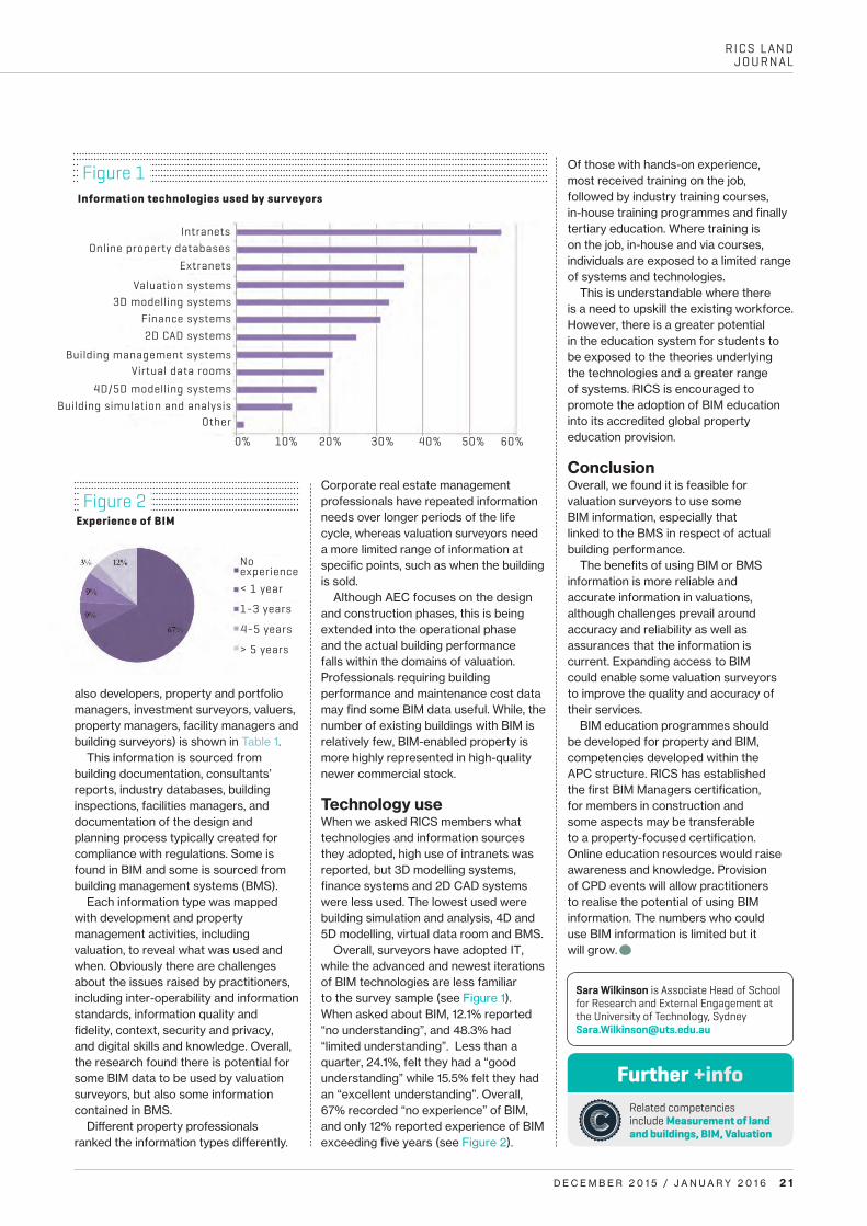
Studies have focused on AEC and have disregarded activities that lie upstream and downstream of design and construction. In a series of UK and Australian workshops with experienced property professionals, we enquired about the types of information
needed to deliver professional services, where this information was obtained, and when the data was needed. The information was ranked in importance in respect of various tasks, including valuation.
The property life cycle Surveys in the UK, US and Australia showed most clients believed that there was a positive return on investment when BIM was used; for example, when assessing sustainability in a feasibility study, in respect of likely ratings under BREEAM, LEED or Green Star.
There is a value premium in sustainable commercial property in the three areas. By using BIM data and simulations, clients can be informed of the environmental, social and economic costs and benefits of these options, allowing them to make informed decisions, such as considering the impact on value.
In AEC projects, life cycle is defined as: pre-design (project feasibility), schematic design, detailed design, construction documentation, construction, and operation/maintenance. Clients are the only stakeholder involved but when development and property management activities are taken into consideration, a more extensive life cycle emerges:
b conception b planning and feasibility b preparation b execution b operation and maintenance b recommissioning.
Property information The information types used by valuation surveyors fell into five categories:(1) market and location data (2) property data describing plot of land (3) property data describing economic information (4) building information (5) process qualities.
The information sourced, organised and (re)used by valuation surveyors (and
Sara Wilkinson reports on RICS research exploring the ‘value dimension’ in building information models
A new dimension
Categories of data for survey
Market data b National market data b State, regional and neighbourhood
market data b Listings, recent sales, and auctions
data b Property transfers data b Property marketing statistics
Property location data
b Macro location data b Micro location data
Property site data
b Property lot attributes b Utilities b Environmental attributes b Surrounding building context b Property development details
Financial data
b Payments in b Payments out b Vacancy/letting b Tenancy occupier data
Building data
b Spatial attributes b 3D model objects (elements) and
properties (parameters) b Building documentation and images
Real estate data b Property value attributes b Property imagery b Property activity b Property insurance attributes b Property insurance rate variables
Project data b Planning and feasibility data, b Design management data b Construction process b Management data
Operations and maintenance data b Maintenance, alteration and repair b Asset monitoring and tracking b Space management
Information categories
Source: adapted Wilkinson & Jupp, 2015
Table 1
RICS LAND JOURNAL
D E C E M B E R 2 0 1 5 / J A N U A R Y 2 0 1 6 2 1
also developers, property and portfolio managers, investment surveyors, valuers, property managers, facility managers and building surveyors) is shown in Table 1.
This information is sourced from building documentation, consultants’ reports, industry databases, building inspections, facilities managers, and documentation of the design and planning process typically created for compliance with regulations. Some is found in BIM and some is sourced from building management systems (BMS).
Each information type was mapped with development and property management activities, including valuation, to reveal what was used and when. Obviously there are challenges about the issues raised by practitioners, including inter-operability and information standards, information quality and fidelity, context, security and privacy, and digital skills and knowledge. Overall, the research found there is potential for some BIM data to be used by valuation surveyors, but also some information contained in BMS.
Different property professionals ranked the information types differently.
Corporate real estate management professionals have repeated information needs over longer periods of the life cycle, whereas valuation surveyors need a more limited range of information at specific points, such as when the building is sold.
Although AEC focuses on the design and construction phases, this is being extended into the operational phase and the actual building performance falls within the domains of valuation. Professionals requiring building performance and maintenance cost data may find some BIM data useful. While, the number of existing buildings with BIM is relatively few, BIM-enabled property is more highly represented in high-quality newer commercial stock.
Technology useWhen we asked RICS members what technologies and information sources they adopted, high use of intranets was reported, but 3D modelling systems, finance systems and 2D CAD systems were less used. The lowest used were building simulation and analysis, 4D and 5D modelling, virtual data room and BMS.
Overall, surveyors have adopted IT, while the advanced and newest iterations of BIM technologies are less familiar to the survey sample (see Figure 1). When asked about BIM, 12.1% reported “no understanding”, and 48.3% had “limited understanding”. Less than a quarter, 24.1%, felt they had a “good understanding” while 15.5% felt they had an “excellent understanding”. Overall, 67% recorded “no experience” of BIM, and only 12% reported experience of BIM exceeding five years (see Figure 2).
Of those with hands-on experience, most received training on the job, followed by industry training courses, in-house training programmes and finally tertiary education. Where training is on the job, in-house and via courses, individuals are exposed to a limited range of systems and technologies.
This is understandable where there is a need to upskill the existing workforce. However, there is a greater potential in the education system for students to be exposed to the theories underlying the technologies and a greater range of systems. RICS is encouraged to promote the adoption of BIM education into its accredited global property education provision.
ConclusionOverall, we found it is feasible for valuation surveyors to use some BIM information, especially that linked to the BMS in respect of actual building performance.
The benefits of using BIM or BMS information is more reliable and accurate information in valuations, although challenges prevail around accuracy and reliability as well as assurances that the information is current. Expanding access to BIM could enable some valuation surveyors to improve the quality and accuracy of their services.
BIM education programmes should be developed for property and BIM, competencies developed within the APC structure. RICS has established the first BIM Managers certification, for members in construction and some aspects may be transferable to a property-focused certification. Online education resources would raise awareness and knowledge. Provision of CPD events will allow practitioners to realise the potential of using BIM information. The numbers who could use BIM information is limited but it will grow. C
Experience of BIMFigure 2
Information technologies used by surveyors
Figure 1
IntranetsOnline property databases
Extranets
Valuation systems3D modelling systems
Finance systems2D CAD systems
Building management systemsVirtual data rooms
4D/5D modelling systems
Other
No experience
1-3 years
4-5 years
> 5 years
< 1 year
0% 10% 20% 30% 40% 50% 60%
Building simulation and analysis
Related competencies include Measurement of land and buildings, BIM, Valuation
Sara Wilkinson is Associate Head of School for Research and External Engagement at the University of Technology, Sydney [email protected]
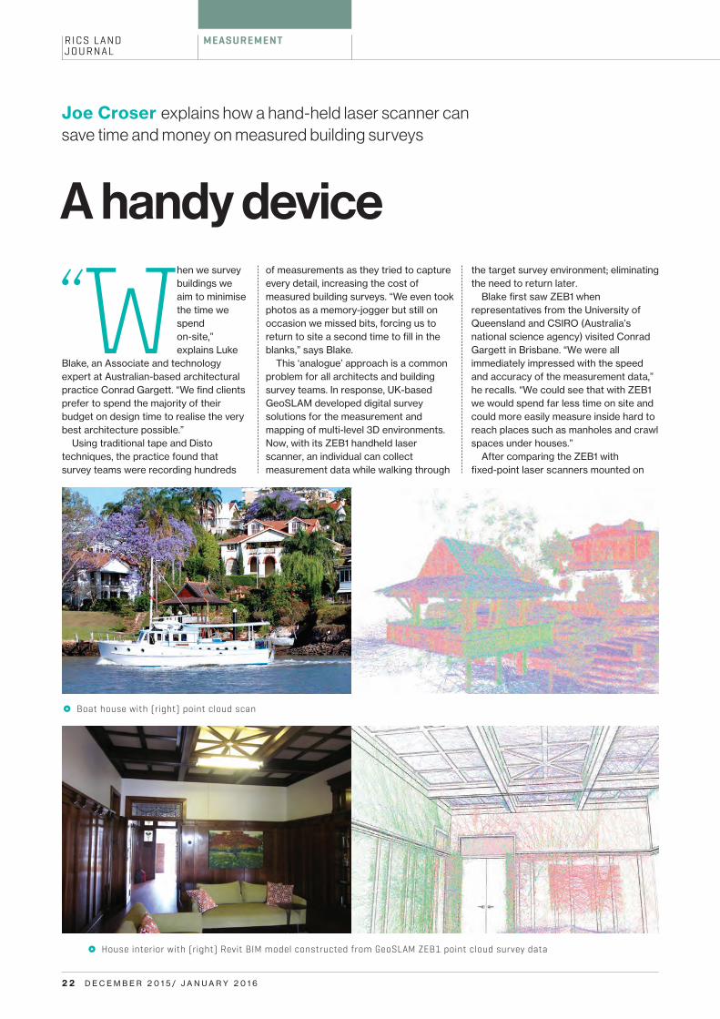
RICS LAND JOURNAL
2 2 D E C E M B E R 2 0 1 5 / J A N U A R Y 2 0 1 6
MEASUREMENT
Joe Croser explains how a hand-held laser scanner can save time and money on measured building surveys
A handy device
When we survey buildings we aim to minimise the time we spend on-site,” explains Luke
Blake, an Associate and technology expert at Australian-based architectural practice Conrad Gargett. “We find clients prefer to spend the majority of their budget on design time to realise the very best architecture possible.”
Using traditional tape and Disto techniques, the practice found that survey teams were recording hundreds
k Boat house with (right) point cloud scan
k House interior with (right) Revit BIM model constructed from GeoSLAM ZEB1 point cloud survey data
of measurements as they tried to capture every detail, increasing the cost of measured building surveys. “We even took photos as a memory-jogger but still on occasion we missed bits, forcing us to return to site a second time to fill in the blanks,” says Blake.
This ‘analogue’ approach is a common problem for all architects and building survey teams. In response, UK-based GeoSLAM developed digital survey solutions for the measurement and mapping of multi-level 3D environments. Now, with its ZEB1 handheld laser scanner, an individual can collect measurement data while walking through
the target survey environment; eliminating the need to return later.
Blake first saw ZEB1 when representatives from the University of Queensland and CSIRO (Australia’s national science agency) visited Conrad Gargett in Brisbane. “We were all immediately impressed with the speed and accuracy of the measurement data,” he recalls. “We could see that with ZEB1 we would spend far less time on site and could more easily measure inside hard to reach places such as manholes and crawl spaces under houses.”
After comparing the ZEB1 with fixed-point laser scanners mounted on

RICS LAND JOURNAL
D E C E M B E R 2 0 1 5 / J A N U A R Y 2 0 1 6 2 3Images © GeoSLAM
tripods, the team found that the scanner was easier to use, offered greater mobility and enabled survey teams to complete measured building surveys in a fraction of the usual time. “We recently spent three months measuring 12 heritage buildings using a tape and Disto,” explains Blake. “With ZEB1 we could have completed all 12 in just one week.”
During the trial, the survey team learned a number of valuable lessons. “To achieve a high level of accuracy we break up our scans into logical groups and we close the loop on every scan,” says Blake. “For example, we completed the survey of a three-storey house using four separate scans: ground floor, first floor, second floor, and external envelope.” Back in the drawing office, the team aggregated the scan data to reconstruct the building inside their building information modelling (BIM) software environment. “We bring the scans into Autodesk Revit as links and align them so we can accurately build our virtual model.”
With this scan-to-BIM workflow, Conrad Gargett is able to omit the usual scan registration phase, most common when using multiple fixed-point scan locations, saving time and money. The team is also achieving accuracy levels of +/-10mm in some places, which according to Blake, “compares favourably with a Disto in real world conditions.”
The levels of accuracy achieved by Conrad Gargett while using the GeoSLAM ZEB1 could be aligned with International Property Measurement Standards (IPMS) and the new RICS Property Measurement 1st edition 2015. Relative accuracy tolerances of +/-25mm can be achieved in compact buildings, and ongoing industry testing compares it favourably with ‘traditional’ laser scanning when dealing with large areas.
Best practice procedures such as the inclusion of ‘survey control’ is still needed to reduce absolute control errors and the accurate linking of building elements, for example rooms and floors. But James Kavanagh, RICS Land Director, comments: “It is a wonderful technology with a great future ahead of it. Possible applications are myriad and it could be a perfect solution for valuation and agency measured surveys when medium accuracy requirements (1:100 – 1:500 scale) are needed.”
The ZEB1 advantage realised by Conrad Gargett is even greater. According to Blake: “Unlike a measuring tape or Disto, which takes a single measurement between two walls,
About ZEB1
The ZEB1 is the first truly mobile lightweight hand-held laser scanner and is suitable for use in applications including mining, forensics, architecture, forestry, stock piles and rapid visualisation.
With ZEB1 in hand, the user can simply walk through the target survey environment recording more than 40,000 measurement points per second without the need for external positioning data such as GNSS.
The ZEB1 works best in feature-rich environments while on the move, so there is typically no need for targets and absolutely no need for a tripod.
Once the data has been collected, it can be uploaded to the GeoSLAM Cloud, where SLAM software transforms the survey measurements into a fully registered point cloud. Thereafter, the data can be downloaded (on a pay-as-you-go basis) for use inside all major CAD software.
With this finance-friendly business model, the GeoSLAM solution eliminates the need for upfront software costs and annual maintenance charges.
GeoSLAM is a joint venture between CSIRO and the UK’s 3D Laser Mapping, provider of LiDAR solutions to the mining industry and the inventor of Street Mapper mobile system.
Related competencies include Spatial data capture and presentation (advanced mapping), Mapping, Measurement of land and buildings
Joe Croser is Managing Director at Oundle [email protected]
k The scanner collects more then 40,000 measurement points/second
the ZEB1 takes thousands. Our Revit users can then pick the average of all measurements as a reliable distance when constructing their BIM models.”
There are, of course, situations where greater levels of accuracy may be required; perhaps where steelwork is fabricated off site before being bolted together on-site. In such a scenario, Blake’s survey team may return to site to check those areas with a steel tape or a hand laser.
“We have enjoyed great success with ZEB1 because we set expectations honestly; we are clear with stakeholders that ZEB1 is not a fixed-point scanner and as a result you will not get a beautiful, dense, colourful point cloud. What you do get is a very fast way to measure a building far more comprehensively than you might with a tape measure and at a fraction of the cost. For our needs the ZEB1 is perfect 95% of the time.” C
More information>Conrad Gargett is at the forefront of architecture in Australia with a legacy of prominent and enduring designs. Since 1890, the practice has grown and now operates from offices in Brisbane, Sydney, and Townsville to deliver projects across health, heritage, research, defence, education and commercial sectors.

Images © Shutterstock
RICS LAND JOURNAL
2 4 D E C E M B E R 2 0 1 5 / J A N U A R Y 2 0 1 6
L A N D R I G H T S
Christopher Barlow looks at the benefits of building modern property and land valuation systems for developing countries
Testing the theory
A significant gap separates countries making the leap from ‘developing’ to ‘developed’ economic growth. Peruvian economist
Hernando de Soto, author of The mystery of capital, believes the chasm that separates countries is attributable to the formalisation of land and property rights. As a consequence of exclusion, a black market economy exists, according to de Soto, which results in ‘dead capital’ that can neither be taxed, capitalised, nor protected under the rule of law.
According to the Lincoln Land Institute, OECD member nations – a collection of ‘developed’ plus middle-income countries such as Mexico and Colombia – generate on average 2.12% of GDP from property taxes. In comparison, the percentage for developing nations is 0.6%.
A clear link exists between a government achieving self-sustainable and self-managed revenues for their people and its ability to operate the
institutions and technology that serve to generate and process those revenues.
Valuation information and data is under-used. This is especially acute in the developing world. Worse, there seems to be a prescribed linear notion that without land rights recording and registration, effective valuation and property tax systems cannot be implemented.
Richard Almy, in his formidable work A global compendium and meta-analysis of property tax systems, refers to “a little studied topic” – the effectiveness and costs of valuation systems and prescribes strategies – “for economising on valuation”.
This relates to what the industry refers to as the 3Ss of a land information or property tax system project — designed with sustainability, security, and scalability as a guiding standard. There are two bases of the 3S; operational and technical, which are interrelated and interdependent (see Table 1).
It was against this backdrop that Thomson Reuters endeavoured to examine more closely the benefits of a valuation modernisation project for a
specific country, applying a model developed by international consulting firm KPMG to the City of Cape Town’s Valuation Office modernisation project.
Cape Town studyThe City of Cape Town’s Valuation Department identified three areas to improve.
b increase productivity and efficiency b improve transparency and
accountability b increase accuracy.
In 2009, the city implemented Thomson Reuters Aumentum Valuation system, covering records management, workflow tools, reporting, and audit trail functions.
The KPMG study investigated benefits at department, city, and also societal levels, applying a ‘theory of change’ impact analysis, defined as: “The process of assessing the consequences/impacts likely to flow from a specific course of action. The focus is on the impacts that alter the manner in which people live, work, and relate to one another.”
Sustainability Security Scalability
Operational Is training available to ensure long-term capacity development and skill transfer for staff?
Does the modernisation effort improve the fairness and equitability of the processes?
Does the solution integrate with other government bodies, such as the courts and the treasury?
Technical Can the system streamline processes for meeting the expected long-term demand for government services?
Are protections in place to thwart hackers and viruses?
Can the system adapt to new technologies such as mobile, GPS, maps and imagery?
Twin bases of 3STable 1

RICS LAND JOURNAL
D E C E M B E R 2 0 1 5 / J A N U A R Y 2 0 1 6 2 5
The impacts Sustainability The modernisation project served to reduce the cost of general valuation, increase staff productivity, add more property taxes to the tax roll, and reduce the number of citizens’ objections. By all measures, the valuation offices achieved their goals.
From 2000 to 2014, the city logged a 61% increase in the number of properties on the tax roll. From fiscal years 2008-09 to 2013-14, government revenue from property taxes increased 71% — US$187m. This gain cannot be solely attributable to the increase in the number of properties on the tax roll. There are other factors such as inflation and rising property values (see Figure 1).
Modernisation was designed to reduce costs while enhancing revenue generation. From 2000 to 2009, general valuation costs were reduced by Rand 94m (US$7.7m) with the introduction of improved methods, processes, and technology. Adding the increase in tax revenues from 2008-09, the return of investment from the cost savings and revenue increase versus the system cost, the city had a return of $97 for each dollar invested.
Again, not all of the cost savings, nor all of the revenue increase, are
attributable to the technology. This needs to be considered in the light of the city’s entire modernisation effort, inclusive of legislative changes.
Scalability Improving data accuracy and accessibility led to greater reliance on the valuation roll to check the authoritative ownership status. Scaling this system for greater use by more stakeholders, such as through web access, and having trust and confidence in this information source, has spread the use of this data across government.
One example is verifying seller information as a check against fraudulent land sales. This is an acute problem across Africa and many other developing nations, with very large black market for land and property sales. The valuation roll identifies those responsible for paying taxes, and discourages nefarious practices.
The city’s transportation department is using the valuation roll to create new bus routes as the values of homes in specific townships determines demand for services. The data is being scaled to connect low-income townships with transportation to central business districts. As a smart city, Cape Town recognises that urbanisation requires
getting people closer to jobs.The treasure trove of data also helps the municipality for planning purposes. Future analytical applications could include extrapolating information on predicted future government revenues to support either areas with home values, or by conducting planning scenarios based on the impact of a rising or falling tax revenue base and the ability of the government to deliver services or infrastructure projects.
Security The importance of security of land tenure is stressed, and government effort to value properties to generate tax revenue and encourage more active participation are a key outcome of the modernisation project.
More people have been spurred to join the formal system, and the Cape Town Municipal High Court bases estate values and decisions on this information. First, ownership rights can be authenicated from the valuation roll and secondly, land value can be queried when making decisions over estate inheritance. This is hugely important for parents, who want to be assured that their family or next of kin will receive their property and land. They want rights well recorded by the courts, and these rights to have an authoritative rather than arbitrary value assigned for this property.
The report also identifies a link between bank lending rates, and the use of government valuation data to support lending decisions based on collateral – as a source to confirm and identify land ownership rights associated to an individual’s collateral assets.
Cape Town has instigated an incentive programme to support people whose incomes fall below a certain threshold by offering them free water management and leak services. Since 2003, they have added 18% more households, in total supporting 238,000 households.
To instill trust and belief that the processes and systems are fair and equitable, the city is providing the incentive before instituting taxation –
Tax revenue from property rates
Figure 1
n

Images ©2 6 D E C E M B E R 2 0 1 5 / J A N U A R Y 2 0 1 6
RICS LAND JOURNAL
L A N D R I G H T S
engendering an understanding of the benefit of the formal system.
The African Tax Institute summarised this point in its recent report How property tax would benefit Africa. “The future of African national and municipal governments will depend on institutions and tax policy that are equitable, improve local service delivery and encourage compliance through establishing a social contract between taxpayers and the state. Property tax is one of the more effective means of realising these goals.”
Future applicationsThomson Reuters commissioned the report to add to the professional body of knowledge so it can, in partnership with governments, better assist design, fund, plan for, and support modernisation. The KPMG approach has great applicability for other governments, especially in the 3S framework.
Practical applications include: b measuring the sustained
effectiveness, relevance, and efficiency of a valuation system
b refine future interventions to scale such as permitting knowledge sharing among government departments for more efficient government planningenhance a valuation department’s
understanding of the system and how it contributes to improving security (be it land security, market trust, or formalisation).
It has been recognised, such as through research Thomson Reuters conducted with the US National Association of Counties, that deeper and better analytics is a top technology trendfor governments. What we are now seeing is only the tip of the iceberg for societal and government-wide gains related to the use of authoritative valuation information. b
n To read the KPMG Cape Town study, visit http://tmsnrt.rs/1KZsaiv
Related competencies include Cadastre and land management, Taxation, Property records and information
Christopher Barlow is Director, Strategic Relations and Communications at Thomson ReutersChristopher.barlow@ ThomsonReuters.com
Top 10 valuation benefits
1. It supports evidence of land tenure security for people.
2. This information is a check against fraudulent land sales, as the valuation roll is a reference point for individuals’ responsibility to pay tax.
3. Valuation information serves to confirm collateral asset important in receiving credit.
4. It supports courts when arbitrating land disputes or with estates rulings.
5. Land and property, and the economic value from land resources (such as agriculture crops) may be insured, as based on the value of the resource.
6. It creates a clear picture of the land base for a jurisdiction: how much land there is, who has what rights, and how much the land is worth.
7. Data aids planning and policy making by allowing for highly targeted government services and infrastructure spend.
8. Compensation for compulsory acquisition or for eminent domain claims, may be more fairly and equitably decided, including other tenure forms, such as customary rights.
9. Transparency may be improved to share the derived value of other land resources, such as timber, minerals, or agriculture commodity types, including biodiversity.
10. To establish a taxable rate and tax roll to implement a fair and equitable property tax system.
n
Image © Shutterstock

RICS LAND JOURNAL
A DV E RT I S I N G
Find out more at rics.org/cpdfoundation
CPD FoundationAn annual subscription that’s easy, convenient and an affordable way to help achieve your formal CPD goals:• Easily record your CPD activity
• Attend seminars held throughout the UK
• Access up to 100 topics covering surveying for land, property and the built environment
• Watch recorded seminars on demand at a time and place convenient to you.
20910-RICS-CPD Journal half-pg ad-174x127.5mm.indd 1 28/09/2015 12:51
Changing the Skyline for 67 YearsProviding Award-Winning* services to the built environment & construction sector
A Culture of Safety
• Demolition• Asbestos Removal• Site Reclamation,
Remediation & Clearance• Earthworks• Aggregates - Quarried
& Recycled
Please call us on:Tel: 01661 832422E-mail: [email protected]
*Construction News’ Demolition Specialists of the Year 2014
Brownfield Development Specialists
To advert ise contact Emma Kennedy +44(0)20 7871 5734 or [email protected]
D E C E M B E R 2 0 1 5 / J A N U A R Y 2 0 1 6 2 7

Fl o o d M
app
ing
I n fra structu
re
U tilitie
s
U r b a n Pla
nn
ing
www.bluesky-world.com 01530 518 518 [email protected]
BS0
133A
D/R
ICS/
1215
C a l l u s f o r a n y L i D A R s u r v e y r e q u i r e m e n t s .
N o t a s e x p e n s i v e a s y o u m i g h t t h i n k !
P l u s
T h e U K ’s l a r g e s t L i D A R d a t a b a s e a v a i l a b l e o n l i n e f o r i n s t a n t d o w n l o a d
www.b lue sky -wo r ld . com
T h i n k
T h i n k