
LAN10072 EMP VA2 - Landcorp South/Gracetown... · Margaret River Local Planning Scheme No. 1 and...
92
Shire of Augusta-M River Local Plannin Scheme No. 1 Environmental Manage DRAFT Prepared for LandCorp by Strategen December 2012 Margaret ng ement Plan
-
Upload
truongquynh -
Category
Documents
-
view
213 -
download
0
Transcript of LAN10072 EMP VA2 - Landcorp South/Gracetown... · Margaret River Local Planning Scheme No. 1 and...
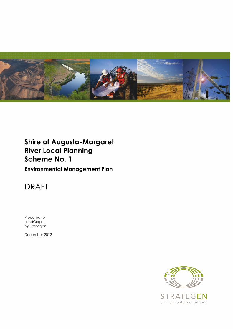
Shire of Augusta-Margaret
River Local Planning
Scheme No. 1
Environmental Management Plan
DRAFT
Prepared for
LandCorp
by Strategen
December 2012
Margaret
River Local Planning
Environmental Management Plan


Shire of Augusta-Margaret
River Local Planning Scheme
No. 1
Environmental Management Plan
DRAFT
Strategen is a trading name of
Strategen Environmental Consultants Pty Ltd
Level 2, 322 Hay Street Subiaco WA
ACN: 056 190 419
December 2012
Disclaimer and Limitation
This report has been prepared for the exclusive use of the Client, in accordance with the agreement
between the Client and Strategen (“Agreement”).
Strategen accepts no liability or responsibility whatsoever for it in respect of any use of or reliance
upon this report by any person who is not a party to the Agreement.
In particular, it should be noted that this report is a qualitative assessment only, based on the scope of
services defined by the Client, budgetary and time constraints imposed by the Client, the information
supplied by the Client (and its agents), and the method consistent with the preceding.
Strategen has not attempted to verify the accuracy or completeness of the information supplied by the
Client.
Copyright and any other Intellectual Property arising from the report and the provision of the services
in accordance with the Agreement belongs exclusively to Strategen unless otherwise agreed. This
document may not be reproduced or disclosed to any person other than the Client without the express
written authority of Strategen unless the document has been released for referral and assessment of
proposals.
Client: LandCorp
Report Version Revision No.
Purpose Strategen author/reviewer
Submitted to Client
Copies Date
Preliminary Draft Report VA0 For preliminary review and provision of information by client
P Brand, M Cumbers, M Brook, T Santini, R Vellacot t/ D Newsome, C Welker, M Cumbers
Electronic (email)
21/04/11
Draft Report VA1 For client acceptance and review by EPA
P Brand / D Newsome Electronic (email and CD-ROM
respectively)
10/06/11
Draft Report VA2 For client review P Brand / D Newsome Electronic (email)
10/06/11
Final Report VA3 For client acceptance and review by WAPC
Draft Strategen Shire of Augusta-Margaret River Local Planning Scheme No. 1
LAN10072_EMP_VA2 - 10/12/2012
TABLE OF CONTENTS
1. INTRODUCTION 1
1.1 LOCATION 1
1.2 BACKGROUND 1
1.3 PURPOSE AND SCOPE OF EMP 4
1.4 STRUCTURE OF EMP 4
1.5 FIRE MANAGEMENT PLAN 5
2. DESCRIPTION OF SCHEME AMENDMENT AND ASSOCIATED DEVELOPMENT
CONCEPT 6
2.1 ENVIRONMENTAL SETTING 6
2.2 OVERVIEW OF DEVELOPMENT CONCEPT 6
3. BIODIVERSITY MANAGEMENT PLAN 8
3.1 DESCRIPTION 8
3.1.1 Vegetation and flora 8
3.1.2 Fauna habitat 8
3.1.3 Fauna 8
3.2 ENVIRONMENTAL ASPECTS TO BE MANAGED 9
3.3 ENVIRONMENTAL OBJECTIVES, TARGETS AND INDICATORS 10
3.4 MITIGATION MEASURES 10
3.4.1 Conditions of occupation 13
3.4.2 Other benefits 13
3.5 MONITORING ACTIONS 16
3.6 CONTINGENCY ACTIONS 16
4. DRAINAGE AND NUTRIENT MANAGEMENT PLAN 18
4.1 DESCRIPTION 18
4.2 ENVIRONMENTAL ASPECTS TO BE MANAGED 18
4.3 ENVIRONMENTAL OBJECTIVES, TARGETS AND INDICATORS 18
4.4 MITIGATION MEASURES 19
4.4.1 Conditions of occupation 20
4.4.2 Other benefits 20
4.4.3 Compliance with policy 20
4.5 MONITORING ACTIONS 26
4.6 CONTINGENCY ACTIONS 26
5. LEEUWIN-NATURALISTE NATIONAL PARK MANAGEMENT PLAN 27
5.1 DESCRIPTION 27
5.2 ENVIRONMENTAL ASPECTS TO BE MANAGED 27
5.3 ENVIRONMENTAL OBJECTIVES, TARGETS AND INDICATORS 27
5.4 MITIGATION MEASURES 28
5.4.1 Other benefits 29

Draft Strategen Shire of Augusta-Margaret River Local Planning Scheme No. 1
LAN10072_EMP_VA2 - 10/12/2012
5.5 MONITORING ACTIONS 30
5.6 CONTINGENCY ACTIONS 30
6. ABORIGINAL HERITAGE MANAGEMENT 31
6.1 DESCRIPTION 31
6.2 ENVIRONMENTAL ASPECTS TO BE MANAGED 31
6.3 ENVIRONMENTAL OBJECTIVES, TARGETS AND INDICATORS 31
6.4 MITIGATION MEASURES 32
6.5 MONITORING ACTIONS 32
6.6 CONTINGENCY ACTIONS 33
7. VISUAL AMENITY 34
7.1 DESCRIPTION 34
7.2 ENVIRONMENTAL ASPECTS TO BE MANAGED 34
7.3 ENVIRONMENTAL OBJECTIVES, TARGETS AND INDICATORS 34
7.4 MITIGATION MEASURES 34
8. WASTE MANAGEMENT 36
8.1 DESCRIPTION 36
8.2 ENVIRONMENTAL ASPECTS TO BE MANAGED 36
8.3 ENVIRONMENTAL OBJECTIVES, TARGETS AND INDICATORS 36
8.4 MITIGATION MEASURES 36
8.4.1 Conditions of occupation 37
8.4.2 Other benefits 37
8.5 MONITORING ACTIONS 37
8.6 CONTINGENCY ACTIONS 38
9. SOIL CONTAMINATION MANAGEMENT 39
9.1 DESCRIPTION 39
9.2 ENVIRONMENTAL ASPECTS TO BE MANAGED 39
9.3 ENVIRONMENTAL OBJECTIVES, TARGETS AND INDICATORS 39
9.4 MITIGATION MEASURES 40
9.5 MONITORING ACTIONS 41
9.6 CONTINGENCY ACTIONS 41
10. DUST MANAGEMENT 42
10.1 DESCRIPTION 42
10.2 ENVIRONMENTAL ASPECTS TO BE MANAGED 42
10.3 ENVIRONMENTAL OBJECTIVES, TARGETS AND INDICATORS 42
10.4 MITIGATION MEASURES 42
10.5 MONITORING ACTIONS 43
10.6 CONTINGENCY ACTIONS 44
11. NOISE MANAGEMENT 45
11.1 DESCRIPTION 45

Draft Strategen Shire of Augusta-Margaret River Local Planning Scheme No. 1
LAN10072_EMP_VA2 - 10/12/2012
11.2 ENVIRONMENTAL ASPECTS TO BE MANAGED 45
11.3 ENVIRONMENTAL OBJECTIVES, TARGETS AND INDICATORS 45
11.4 MITIGATION MEASURES 46
11.5 MONITORING ACTIONS 46
11.6 CONTINGENCY ACTIONS 46
12. MANAGEMENT FRAMEWORK 48
12.1 COMMUNICATIONS AND TRAINING 48
12.1.1 Internal communications 48
12.1.2 External communications 48
12.1.3 Inductions and training 48
12.2 ENVIRONMENTAL INCIDENT REPORTING 49
12.3 PUBLIC COMPLAINT RESOLUTION 50
12.4 STAKEHOLDER CONSULTATION 50
12.5 AUDITING 51
12.6 REVIEW AND REVISION 51
13. REFERENCES 52

Draft Strategen Shire of Augusta-Margaret River Local Planning Scheme No. 1
LAN10072_EMP_VA2 - 10/12/2012
LIST OF TABLES
1. Environmental objectives, targets and indicators for biodiversity management 10
2. Mitigation measures for biodiversity 10
3. Monitoring actions for biodiversity 16
4. Contingency actions for biodiversity 17
5. Environmental objectives, targets and indicators for drainage and nutrient
management 19
6. Mitigation measures for drainage and nutrient management 19
7. Comparison of the Scheme Amendment and development concept with relevant
sections of the Leeuwin-Naturaliste Ridge Policy 22
8. Compliance of the Drainage and Nutrient Management Plan with water resource
considerations outlined in WAPC State Planning Policy No. 2 23
9. Compliance of the Drainage and Nutrient Management Plan with the principles
and goals of WAPC State Planning Policy No. 2.9 24
10. Compliance of the Drainage and Nutrient Management Plan with the management principles outlined in the Western Australian Stormwater
Management Manual 25
11. Monitoring actions for drainage and nutrient management 26
12. Contingency actions for drainage and nutrient management 26
13. Environmental objectives, targets and indicators for the Leeuwin-Naturaliste National Park 27
14. Mitigation measures for the Leeuwin-Naturaliste National Park 28
15. Monitoring actions for Leeuwin-Naturaliste National Park during construction 30
16. Contingency actions for Leeuwin-Naturaliste National Park during construction 30
17. Environmental objectives, targets and indicators for Aboriginal heritage 32
18. Mitigation measures for Aboriginal heritage during construction 32
19. Monitoring actions for Aboriginal heritage during construction 32
20. Contingency actions for Aboriginal heritage during construction 33
21. Mitigation measures for visual amenity 34
22. Environmental objectives, targets and indicators for waste 36
23. Mitigation measures for waste 36
24. Monitoring actions for waste during construction 38
25. Contingency actions for waste during construction 38
26. Environmental objectives, targets and indicators for soil contamination management 39
27. Mitigation measures for soil contamination management 40
28. Monitoring actions for soil contamination 41
29. Contingency actions for soil contamination 41
30. Environmental objectives, targets and indicators for dust 42
31. Mitigation measures for dust during construction 43
32. Monitoring actions for dust during construction 43
33. Contingency actions for dust 44
Draft Strategen Shire of Augusta-Margaret River Local Planning Scheme No. 1
LAN10072_EMP_VA2 - 10/12/2012
34. Environmental objectives, targets and indicators for noise 45
35. Management actions for noise during construction 46
36. Monitoring actions for noise 46
37. Contingency actions for noise 47
38. Proposed environmental incident procedures 49
LIST OF FIGURES
1. Regional location 2
2. Location of scheme amendment area 3
3. Concept plan of proposed sustainable residential development 7
4. Boundaries of clearing and rehabilitation associated with this Scheme Amendment 15
LIST OF APPENDICES
1. Fire Management Plan
2. Procedures to Minimise Risk to Western Ringtail Possums During Vegetation Clearing
and Building Demolition


Draft Strategen Shire of Augusta-Margaret River Local Planning Scheme No. 1
LAN10072_EMP_VA2 - 10/12/2012 1
1. INTRODUCTION
This Environmental Management Plan (EMP) outlines the mitigation measures to be implemented to
manage any environmental impacts resulting from Amendment No. 2 of the Shire of Augusta-
Margaret River Local Planning Scheme No. 1 and the subsequent development of this land, which is
being proposed by LandCorp.
1.1 LOCATION
The Scheme Amendment relates to an area of land to the south-east of the existing Gracetown
townsite, located approximately 12 kilometres (km) north-west of Margaret River in the south-west of
Western Australia, 270 km south of Perth (Figure 1). The scheme amendment area is located within
Lot 300 Salter St, Gracetown, and is currently Unallocated Crown Land (UCL) (Figure 2). The
subject land covers an area of 14.67 ha.
1.2 BACKGROUND
The existing Gracetown townsite consists of 150 residential units, of which approximately 50 are
occupied by permanent residents. As part of a Cabinet decision, in principle agreement was granted to
plan and develop limited additional residential within the townsite of Gracetown.
LandCorp proposes to develop the scheme amendment area in order to meet market demand for
residential home sites in the area. LandCorp is proposing to expand the existing Gracetown townsite
for a residential development consisting of approximately 136 lots. Amendment of the Shire of
Augusta-Margaret River Local Planning Scheme No. 1 was required to allow development of the
proposed residential area; rezoning the subject land from ‘Parks and Recreation’ to ‘Future
Development’.
In October 2007, this proposed amendment was referred to the Environmental Protection Authority
(EPA) under Section 81 of the Planning and Development Act 2005. The EPA advised of its decision
to assess the scheme, outlining that an Environmental Review (ER) was required to be prepared, in
accordance with the Instructions issued concerning the scope and content of the ER. The proposed
amendment was not assessed by the EPA and the referral became null and void. In May 2011, this
proposed amendment was referred again to the EPA under Section 81 of the Planning and
Development Act 2005. In a notice dated 17 October 2011 the EPA advised of its decision to not
assess the scheme and provided advice and recommendations which have been taken into account by
this EMP.

CAPEL
NANNUP
HARVEY
BOYANUP
MANJIMUP
BRIDGETOWN
COLLIE
BUNBURY
AUGUSTA
PEMBERTON
BUSSELTON
MARGARET RIVER
300000 350000 400000
620
00
00
625
00
00
630
00
00
Figure 1 Regional location
at A4
Scale
0 5 10 15 20
Kilometres
1:750,000
www.strategen.com.au
Source: Geoscience Australia 2006
Note that positional errors may occur in some areasDate: 21/04/2011
Author: awelker
Path: Q:\GIS\Consult\2007\LAN\LAN07081_Gracetown redevelopment (South West - Central West)\April 2011\EMP\Figure 1 Regional location.mxd
Coordinate System: GDA 1994 MGA Zone 50
Legend
Principal Road
Drainage
Project area
Reserves
GRACETOWN
Blackwood River
Margaret River
Vas
se R
iver

Disused quarry and tip
Disused tip
313000 314000 315000
624
90
00
625
00
00
625
10
00
625
20
00
Figure 2 Location of scheme amendment area
at A4
Scale
0 100 200 300 400 500
Meters
1:15,000
www.strategen.com.au
Source: Geoscience Australia 2006
Note that positional errors may occur in some areasDate: 21/04/2011
Author: awelker
Path: Q:\GIS\Consult\2007\LAN\LAN07081_Gracetown redevelopment (South West - Central West)\April 2011\EMP\Figure 2 Scheme amendment area.mxd
Coordinate System: GDA 1994 MGA Zone 50
Legend
Existing community facilities
Residential development area
Leeuwin-Naturaliste National Park
Lot 300

Draft Strategen Shire of Augusta-Margaret River Local Planning Scheme No. 1
LAN10072_EMP_VA2 - 10/12/2012 4
1.3 PURPOSE AND SCOPE OF EMP
The overall purpose of this EMP is to describe measures to protect significant environmental features
in the scheme amendment area and surrounds. This EMP documents LandCorp’s environmental
management objectives and strategies in relation to the proposed development of the scheme
amendment area, including:
• measures to prevent, reduce and mitigate any potential environmental impacts from the Scheme
Amendment and subsequent development concept
• details of the timing and persons responsible for implementation of these measures
• monitoring and reporting procedures.
The EMP addresses the following factors through a suite of management plans that are detailed in
subsequent sections:
• biodiversity management
• drainage and nutrient management
• Aboriginal heritage management
• waste management
• soil contamination management
• dust management
• noise management.
Fire management is addressed separately in the Fire Management Plan (Appendix 1) prepared by
FirePlan WA (2010) (see Section 1.5).
1.4 STRUCTURE OF EMP
The management plans in this EMP have been prepared in accordance with EPA Position Statement
No. 8 – Environmental Protection in Natural Resource Management (EPA 2005) and relevant
Department of Environment and Conservation (DEC) guidelines. Each management plan:
• defines management objectives for the environmental factor it addresses
• describes management measures required to achieve the environmental objectives related to the
environmental factor
• provides a description of monitoring and performance criteria, as required, for meeting the
objectives related to the environmental factor
• describes contingency measures to be implemented in the event of unexpected or unacceptable
environmental outcomes
• outlines responsibilities and timing of implementation for described measures.

Draft Strategen Shire of Augusta-Margaret River Local Planning Scheme No. 1
LAN10072_EMP_VA2 - 10/12/2012 5
The EMP also details the overall environmental management framework, including:
• communications and training
• environmental incident reporting
• public complaint resolution
• stakeholder consultation
• auditing
• review and revision.
1.5 FIRE MANAGEMENT PLAN
This EMP should be read in conjunction with the Fire Management Plan prepared by FirePlan WA
(2010) (Appendix 1).
The Fire Management Plan addresses fire management associated with the residential development
area and details:
• a bush fire hazard assessment
• fire management including:
• road system
• firebreaks and low fuel buffers
• dwelling construction
• building protection zones
• hazard separation zone
• external public open space
• multiple use corridors
• community education
• visitor safety in the event of a bushfire
• fire fighting facilities
• responsibilities of the property owners, developers and Shire of Augusta-Margaret River.
Draft Strategen Shire of Augusta-Margaret River Local Planning Scheme No. 1
LAN10072_EMP_VA2 - 10/12/2012 6
2. DESCRIPTION OF SCHEME AMENDMENT AND ASSOCIATED
DEVELOPMENT CONCEPT
2.1 ENVIRONMENTAL SETTING
The existing physical, biological and social environment of Gracetown and surrounds is detailed in
Chapter 1, Section 2 of the Environmental Review (ER) for the Scheme Amendment.
2.2 OVERVIEW OF DEVELOPMENT CONCEPT
The key components of the Scheme Amendment and associated development concept are:
1. The area of the townsite will be increased by 14.67 ha, to the south-east of the existing townsite,
to include approximately 136 lots which will accommodate 146 housing units.
2. The number of permanent residents in the town will increase by approximately 100 people, based
on the current concept plan for the area to be rezoned.
3. Solar voltaic panels on house roofs will generate electricity and any excess will be exported to the
grid for use elsewhere.
4. A reticulated sewerage treatment system will be established in both the new and existing town
site areas and will replace existing septic tanks.
5. All water required by Gracetown will continue to be supplied from within the town (i.e.
Gracetown will not be connected to Water Corporation Scheme water).
There will be a 21.1 ha fire management area surrounding the scheme amendment area and residential
development for bushfire management, of which approximately 13.42 ha will be within Lot 300.
A wastewater treatment plant is proposed to service the existing and new residences however, as it is
not relevant to this Scheme Amendment assessment, it is not addressed in this document.
Figure 3 provides a conceptual layout of residences within the scheme amendment area.

Shire of Augusta-Margaret River Local Planning Scheme No. 1 Environmental Review
CONCEPT PLAN OF PROPOSED SUSTAINABLE RESIDENTIAL DEVELOPMENT FIGURE
3
Figure 10 Apr-2011 stra
tegen
Draft Strategen Shire of Augusta-Margaret River Local Planning Scheme No. 1
LAN10072_EMP_VA2 - 10/12/2012 8
3. BIODIVERSITY MANAGEMENT PLAN
3.1 DESCRIPTION
3.1.1 Vegetation and flora
The majority of the scheme amendment area is covered by undisturbed native vegetation of the
Gracetown vegetation complex, 71% of this vegetation complex occurs in formal reserves. Two site
vegetation communities (and one ‘degraded’ category) were mapped in the proposed scheme
amendment area by Mattiske (2006a). None of these communities are listed as Threatened Ecological
Communities (TECs) by the DEC or listed under the Commonwealth Environment Protection and
Biodiversity Conservation Act 1999 (EPBC Act).
The condition of the vegetation in the scheme amendment area varies from a mosaic of ‘pristine’ and
‘excellent’, to ‘completely degraded’ in areas where access tracks have been created. The potential for
the occurrence of Dieback (Phytophthora cinnamomi) within the scheme amendment area is
considered relatively low (Mattiske 2008). Of the 35 introduced/weed taxa recorded on-site, only one
(Zantedeschia aethiopica – Arum Lily) is listed as a Declared Plant by the Department of Agriculture
and Food Western Australia (2007).
No Declared Rare Flora species, pursuant to the Wildlife Conservation Act 1950 (Wildlife Act) and
listed by the Western Australian Herbarium (2006), were recorded by Mattiske (2006a; 2006b) during
the two surveys of the scheme amendment area. No Threatened Flora species, pursuant to Section 179
of the Commonwealth EPBC Act, were recorded within the scheme amendment area. One Priority 2
species, Caladenia abbreviata, and one Priority 4 species, Banksia sessilis var. cordata, were recorded
within the scheme amendment area (Mattiske 2006a; Rooks 2008).
A more detailed description of vegetation and flora is contained in Chapter 3, Section 1 of the ER.
3.1.2 Fauna habitat
As mentioned in the Section 3.1.1 above, two vegetation communities occur in the scheme amendment
area and these habitats are common in the local area, including the nearby Leeuwin-Naturaliste
National Park.
The scheme amendment area contains feeding habitat for Carnaby’s and Baudin’s Black-Cockatoo and
is also known to support Quenda and the South-west Carpet Python. A Western Ringtail Possum
(WRP) was recorded on the adjacent Unallocated Crown Land and four dreys (self-built bird-like
nests) were located within the scheme amendment area, however no WRPs were observed during the
surveys.
3.1.3 Fauna
Terrestrial fauna
A total of 154 vertebrate fauna species including birds, mammals, reptile and amphibians could
potentially occur in the scheme amendment area. A variety of invertebrates could also occur in the
area (Western Wildlife 2007).
Conservation significant vertebrate species recorded within the proposed scheme amendment area are:
Draft Strategen Shire of Augusta-Margaret River Local Planning Scheme No. 1
LAN10072_EMP_VA2 - 10/12/2012 9
• Calyptorhynchus baudinii (Baudin’s Black-Cockatoo)
• Calyptorhynchus latirostris (Carnaby’s Black-Cockatoo)
• Isoodon obesulus (Quenda)
• Merops ornatus (Rainbow Bee-eater)
• Morelia spilota imbricata (South-west Carpet Python)
• Pseudocheirus occidentalis (Western Ringtail Possum).
Four invertebrate species of conservation significance were identified on DEC’s Threatened and
Priority Fauna database for the area; however, they are unlikely to occur within the scheme
amendment area due to a lack of suitable habitat.
A more detailed description of the terrestrial fauna of the scheme amendment area is included in
Chapter 3, Section 2 of the ER.
Subterranean fauna
Subterranean fauna, both stygal and troglobitic, have been recorded from several locations in the
vicinity of Gracetown, though no sampling has been completed in Gracetown itself (Biota 2008).
Many of the records in the vicinity are associated with cave systems, although some are associated
with surface water drainage and karstic limestone areas that do not appear to contain significant caves
(Biota 2008).
A more detailed description of the subterranean fauna of the scheme amendment area is included in
Chapter 3, Sections 2 and 3 of the ER.
3.2 ENVIRONMENTAL ASPECTS TO BE MANAGED
The following aspects of the scheme amendment area development have the potential to affect
biodiversity values:
• clearing will remove vegetation and possible significant flora species, and may result in the loss
of terrestrial fauna or lead to the fragmentation or loss of connectivity of habitat
• earthworks and installation of infrastructure leading to alteration of infiltration and runoff
regimes may change the depth of the watertable affecting groundwater-dependent vegetation
and potentially the subterranean microclimate (temperature and humidity in caves and air
spaces). Altering the runoff regime may also affect vegetation through increased erosion or
flooding. Earthworks may also disturb karst and cave formations that may provide habitat for
subterranean fauna
• human presence in the scheme amendment area will increase the risk of further land
disturbance resulting in degradation to vegetation and habitat, and will increase risks associated
with weeds and bush fires. Human presence may also deter fauna from residing in the vicinity
of disturbance areas due to noise emissions and general human activity. Habitation will
increase the risk of introducing feral species (including domestic pets) which may compete for
habitat and food, and may also prey on native species
• vehicle movements during the construction period and associated with the long-term
establishment of development may increase fauna fatalities.
Dust may be generated during clearing and earthworks, and may also result from strong winds over
exposed soil surfaces. Management of dust emissions is outlined in the Dust Management Plan of this
EMP (see Section 9).

Draft Strategen Shire of Augusta-Margaret River Local Planning Scheme No. 1
LAN10072_EMP_VA2 - 10/12/2012 10
The risk of bushfires and fire management practices are outlined in the Fire Management Plan
prepared by FirePlan (2010). This document has been summarised in Section 1.5 and is contained in
Appendix 1.
3.3 ENVIRONMENTAL OBJECTIVES, TARGETS AND INDICATORS
The environmental objectives, targets and key performance indicators (KPIs) for biodiversity are
detailed in Table 1 below.
Table 1 Environmental objectives, targets and indicators for biodiversity management
Objective Target KPI
To ensure that clearing is as approved for the Scheme Amendment and as outlined in the Fire Management Plan.
No clearing or disturbance outside of pre-defined boundaries within the scheme amendment and fire management area, during construction.
Visual observations of clearing operations.
Environmental Incident Reports.
Minimise disturbance to vegetation and local terrestrial fauna populations within the scheme amendment area.
Maintain a minimum of 40% of the scheme amendment area for public open space (approximately 5.8 ha).
Review of aerial photography pre- and post-development.
To minimise the potential for new weeds and diseases to be introduced to the scheme amendment area.
No new weeds introduced to the scheme amendment area.
Monitoring results one year after completion of construction activities.
Dieback (Phytophthora cinnamomi) is not introduced to the scheme amendment area.
Site inspections indicate no evidence of dieback infection.
To minimise the risk of spreading existing weeds within the scheme amendment area.
No significant change to the extent and distribution of Arum Lily (Zantedeschia aethiopica) within one year of completion of construction activities, compared to the extent and distribution prior to construction.
Monitoring results one year after completion of construction activities.
All vehicles to be ‘clean on entry’ to and avoid unintentional movement of soil about the scheme amendment area.
Environmental Incident Reports.
To maintain and enhance ecological linkages within the fire management area.
Rehabilitate an approximately 250 m long access track within the fire management area, to a condition comparable to the surrounding vegetation.
Site inspections.
Rehabilitation monitoring results.
Minimise the effect of feral animals on native terrestrial fauna.
No statistically significant increase in feral animal abundance in the vicinity of the scheme amendment area.
Number of feral animals recorded during baseline surveys compared to subsequent fauna surveys.
Minimise disturbance of the Leeuwin-Naturaliste National Park.
No direct pedestrian access-ways shall be created from the development to the Leeuwin-Naturaliste National Park, unless otherwise agreed with DEC.
Site inspections.
Evidence of agreement with DEC, if access-ways are present.
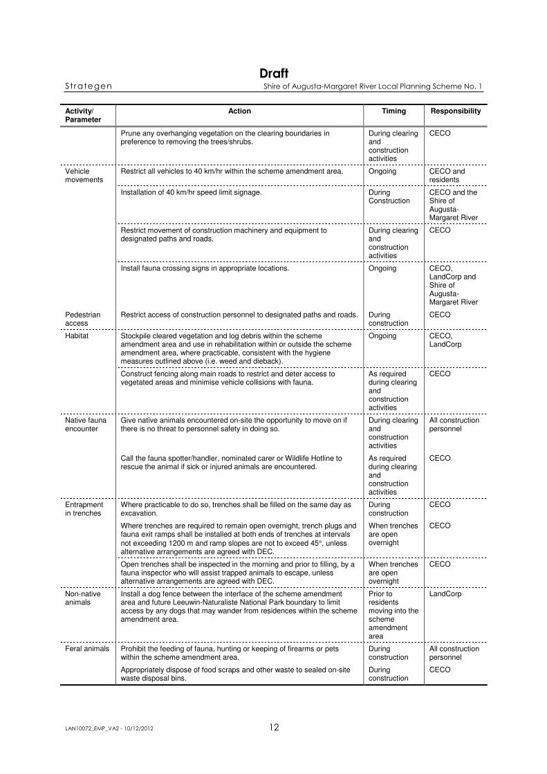
3.4 MITIGATION MEASURES
LandCorp is proposing to disturb a total footprint area of approximately 35.77 ha for the proposed
residential development. The total area of vegetation effected within Lot 300 (28.29 ha) equates to
approximately 10% of the lot. Additionally, specific mitigation measures have been identified to
assist in achieving the biodiversity management objectives (Table 2).
Table 2 Mitigation measures for biodiversity
Activity/ Parameter
Action Timing Responsibility
Surveys Complete a fauna relocation program within the scheme amendment area.
Prior to clearing or earthworks commencing
LandCorp, CECO*

Draft Strategen Shire of Augusta-Margaret River Local Planning Scheme No. 1
LAN10072_EMP_VA2 - 10/12/2012 11
Activity/ Parameter
Action Timing Responsibility
Seed collection
Collect seed from areas to be cleared within the scheme amendment and fire management area; for use in future rehabilitation or landscaping.
Prior to any clearing or earthworks commencing
LandCorp
Induction Implement an induction program for construction personnel which contains information on:
• the requirement to stay within clearing boundaries
• hygiene measures (specifically for dieback and weeds)
• potential for site activities to affect fauna and fauna habitat
• avoidance of important fauna habitat where practicable (e.g. Banksia sessilis var. cordata and Agonis flexuosa)
• fauna encounter procedures.
Prior to clearing or earthworks commencing
CECO
Hygiene Establish hygiene management station/s at the designated entry and exit sites of the scheme amendment area, on designated roads or access tracks.
Prior to clearing or earthworks commencing; During construction
CECO
Clean earth-moving machinery of soil and vegetation, at the hygiene management station/s, prior to entering and leaving the scheme amendment area.
During clearing or earthworks activities
CECO
Prevent weed or dieback-affected road building materials, mulch or fill being brought into the scheme amendment area and rehabilitation area (~250 m of old firebreak).
Ongoing CECO, LandCorp
Restrict the movement of machines and other vehicles to the limits of the areas to be cleared.
During clearing and construction
CECO
No vegetation or soil from areas where Arum Lily is present, shall be utilised in rehabilitation or landscaping works.
Ongoing CECO, LandCorp
Determine with DEC whether it is appropriate (in terms of dieback occurrence) to use vegetation from the scheme amendment and fire management area in off-site areas.
Ongoing CECO, LandCorp
Clearing Maintain a minimum of 40% of the scheme amendment area for public open space (approximately 5.8 ha).
Ongoing CECO, LandCorp and then future developer after subdivision approval
Employ native fauna spotters/handlers during clearing. During clearing activities
CECO, LandCorp
No clearing or disturbance outside of pre-defined boundaries within the scheme amendment and fire management area, during construction (see Figure 4).
During clearing and construction activities
CECO
Clearing shall be in accordance with DEC’s Western Ringtail Possum Clearing Protocol (Appendix 2) and begin adjacent to areas previously disturbed (i.e. existing townsite) and progress outwards to allow fauna movement and relocation ahead of clearing.
During clearing and construction activities
CECO
Clearing will be restricted to 8.6 ha (i.e. 60% of the scheme amendment area) for the construction/building envelopes and roadways.
During clearing and construction activities
CECO
Delineate the boundaries of the vegetation to be cleared in the field with flagging tape, signage or fencing.
Prohibit access beyond these boundaries.
During clearing and construction activities
CECO
Draft Strategen Shire of Augusta-Margaret River Local Planning Scheme No. 1
LAN10072_EMP_VA2 - 10/12/2012 12
Activity/ Parameter
Action Timing Responsibility
Prune any overhanging vegetation on the clearing boundaries in preference to removing the trees/shrubs.
During clearing and construction activities
CECO
Vehicle movements
Restrict all vehicles to 40 km/hr within the scheme amendment area. Ongoing CECO and residents
Installation of 40 km/hr speed limit signage. During Construction
CECO and the Shire of Augusta-Margaret River
Restrict movement of construction machinery and equipment to designated paths and roads.
During clearing and construction activities
CECO
Install fauna crossing signs in appropriate locations. Ongoing CECO, LandCorp and Shire of Augusta-Margaret River
Pedestrian access
Restrict access of construction personnel to designated paths and roads. During construction
CECO
Habitat Stockpile cleared vegetation and log debris within the scheme amendment area and use in rehabilitation within or outside the scheme amendment area, where practicable, consistent with the hygiene measures outlined above (i.e. weed and dieback).
Ongoing CECO, LandCorp
Construct fencing along main roads to restrict and deter access to vegetated areas and minimise vehicle collisions with fauna.
As required during clearing and construction activities
CECO
Native fauna encounter
Give native animals encountered on-site the opportunity to move on if there is no threat to personnel safety in doing so.
During clearing and construction activities
All construction personnel
Call the fauna spotter/handler, nominated carer or Wildlife Hotline to rescue the animal if sick or injured animals are encountered.
As required during clearing and construction activities
CECO
Entrapment in trenches
Where practicable to do so, trenches shall be filled on the same day as excavation.
During construction
CECO
Where trenches are required to remain open overnight, trench plugs and fauna exit ramps shall be installed at both ends of trenches at intervals
not exceeding 1200 m and ramp slopes are not to exceed 45°, unless alternative arrangements are agreed with DEC.
When trenches are open overnight
CECO
Open trenches shall be inspected in the morning and prior to filling, by a fauna inspector who will assist trapped animals to escape, unless alternative arrangements are agreed with DEC.
When trenches are open overnight
CECO
Non-native animals
Install a dog fence between the interface of the scheme amendment area and future Leeuwin-Naturaliste National Park boundary to limit access by any dogs that may wander from residences within the scheme amendment area.
Prior to residents moving into the scheme amendment area
LandCorp
Feral animals Prohibit the feeding of fauna, hunting or keeping of firearms or pets within the scheme amendment area.
During construction
All construction personnel
Appropriately dispose of food scraps and other waste to sealed on-site waste disposal bins.
During construction
CECO

Draft Strategen Shire of Augusta-Margaret River Local Planning Scheme No. 1
LAN10072_EMP_VA2 - 10/12/2012 13
Activity/ Parameter
Action Timing Responsibility
Rehabilitation and landscaping
Rehabilitate and/or landscape disturbed areas that are not to be utilised post-construction.
Within three months after the completion of construction activities
LandCorp, CECO
Utilise only local native flora species in rehabilitation and landscaping activities within the scheme amendment area, including the public open space area. The species used shall include those species with known habitat/feeding value such as Banksia sessilis var. cordata and Agonis flexuosa.
Ongoing LandCorp, CECO and Shire of Augusta-Margaret River
Rehabilitate an approximately 250 m long access track within the fire management area (Figure 4), to a condition comparable to the surrounding vegetation.
Ongoing LandCorp
Weed control Implement a weed control program within the public open space area, and at the interface of the fire management area and Leeuwin-Naturaliste National Park.
Following completion of construction activities
Shire of Augusta-Margaret River
Leeuwin-Naturaliste National Park
No direct pedestrian access-ways shall be created from the development to the Leeuwin-Naturaliste National Park, unless otherwise agreed with DEC.
Ongoing LandCorp and Shire of Augusta-Margaret River
Signage Install street signage in the scheme amendment area to inform residents and the public of:
• regulations for rubbish dumping
• discouraging the feeding of and interaction with native animals
• warning of potential vehicle collisions
Following subdivision approval.
LandCorp, future developer
* CECO: Contractor Environmental Control Officer
3.4.1 Conditions of occupation
The following condition will be placed upon residential lot titles:
• the use of Declared Plants will not be permitted in residential gardens.
This condition will be highlighted to residents and tenants by provision of an information package, as
outlined below in Section 3.4.2.
3.4.2 Other benefits
A number of other initiatives will be implemented as part of the development of the scheme
amendment area, which will have positive outcomes for biodiversity, including:
• provision of an information package to landowners that:
• informs residents about the habitat value and the importance of complying with conditions
and management procedures, such as those on their lot titles and the relevant actions in this
EMP
• encourages the use of local native flora species in gardens, particularly those pre-existing
flora species and those with known habitat/feeding value such as Parrotbush (Banksia
sessilis var. cordata) and Peppermint (Agonis flexuosa)
• informs residents of the regulations regarding the dumping of garden waste
• discourages interaction with, or feeding of, native animals or the undertaking of any other
activity that would otherwise encourage unnatural habits or dependencies
• discourages the keeping of cats.

Draft Strategen Shire of Augusta-Margaret River Local Planning Scheme No. 1
LAN10072_EMP_VA2 - 10/12/2012 14
• the Leeuwin-Naturaliste National Park will be extended to incorporate the remainder of the
vegetated Crown land of Lot 300 (approximately 231 ha), surrounding the scheme amendment
and fire management area
• financial support will be provided to the DEC to facilitate management of the Leeuwin-
Naturaliste National Park
• financial support will be provided to the Shire of Augusta-Margaret River to assist
implementation and maintenance of the Fire Management Plan.
Disused quarry and tip
Disused tip
313000 314000 315000
624
90
00
625
00
00
625
10
00
625
20
00
Figure 4 Conceptual fire management plan
at A4
Scale
0 100 200 300 400 500
Meters
1:15,000
www.strategen.com.au
Source: Geoscience Australia 2006
Note that positional errors may occur in some areasDate: 21/04/2011
Author: awelker
Path: Q:\GIS\Consult\2007\LAN\LAN07081_Gracetown redevelopment (South West - Central West)\April 2011\EMP\Figure 4 Conceptual FMP.mxd
Coordinate System: GDA 1994 MGA Zone 50
Legend
Fire break to be rehabilitated
Existing community facilities
Residential development area
Leeuwin-Naturaliste National Park
Fire management area
Lot 300

Draft Strategen Shire of Augusta-Margaret River Local Planning Scheme No. 1
LAN10072_EMP_VA2 - 10/12/2012 16
3.5 MONITORING ACTIONS
Table 3 provides monitoring actions to enable assessment of the effectiveness of the biodiversity
management actions in place.
Table 3 Monitoring actions for biodiversity
Parameter Frequency Location Purpose Responsibility
Flagging tape, signage or fencing
Daily throughout clearing and earthworks activities
Along clearing boundaries within scheme amendment and fire management area
To ensure that clearing boundaries are clearly marked.
To ensure no unauthorised clearing/access takes place beyond these boundaries.
CECO*
Hygiene Daily during construction activities
Hygiene station/s To ensure that all vehicles, construction machinery (including handheld tools), and footwear is subject to hygiene management procedures when entering and existing the scheme amendment area.
CECO
Fauna injuries/fatalities register
Opportunistically during construction and for the first three years following completion of construction activities
Within scheme amendment area
To assess the best place to install signage, if speed limits should be amended from 40 km/hr, and if an aerial wildlife rope bridge should be installed to assist the safe dispersal of WRP.
CECO, LandCorp, future developer
Extent and distribution of Arum Lily
Following completion of construction activities (one and three years after completion)
Within scheme amendment area
To ensure construction activities did not increase the extent and distribution of Arum Lily.
LandCorp
Rehabilitation Annually for four years Old firebreak (~250 m long)
To ensure the area is rehabilitated to a condition comparable to the surrounding vegetation subject to Fire Management Plan requirements.
LandCorp
Dog fence Every two months once residents have moved into the scheme amendment area
Between the interface of the scheme amendment area and future Leeuwin-Naturaliste National Park boundary
To ensure the fence is intact and capable of limiting access to the Leeuwin-Naturaliste National Park by any dogs that may escape residences within the scheme amendment area.
Shire of Augusta-Margaret River
Fauna survey Two years after completion of construction activities within the scheme amendment area, and then another two years after that.
Scheme amendment area and reference site (as in original Baseline/Level 2 survey)
To compare the occurrence of fauna to that which was recorded prior to development of the scheme amendment area.
LandCorp
* CECO: Contractor Environmental Control Officer
3.6 CONTINGENCY ACTIONS
Table 4 identifies the appropriate contingency actions to be initiated in the event that the objectives for
biodiversity management are not met.

Draft Strategen Shire of Augusta-Margaret River Local Planning Scheme No. 1
LAN10072_EMP_VA2 - 10/12/2012 17
Table 4 Contingency actions for biodiversity
Trigger Action Responsibility
Unauthorised access beyond, or breach of pre-defined clearing boundaries.
1. Investigate cause. CECO*
2. Redefine boundaries if due to inadequate boundary marking.
3. Reinform all personnel of access restrictions beyond clearing boundaries.
4. If disturbance to vegetation requires mitigation, then the area disturbed shall be rehabilitated.
5. An Environmental Incident Report shall be completed.
Less than 40% of the scheme amendment area is public open space as indicated on subdivision plan.
1. Investigate cause. LandCorp
2. Identify ways to increase area of public open space.
3. Implement measures to ensure area of public open space is a minimum of 40% of the scheme amendment area.
New weed introduced or increase in the extent and distribution of Arum Lily within the scheme amendment area.
1. Investigate cause. CECO during construction then LandCorp for one year after the completion of construction
2. Undertake weed control to eradicate introduced weed or reduce extent and distribution of Arum Lily.
3. Monitor success of remedy.
Dieback introduced to the scheme amendment area.
1. Confirm dieback occurrence and investigate cause (including consulting the Environmental Incident Report database).
CECO, LandCorp
2. Implement management to identify the dieback-infected area and prevent access to it (this may include installing fencing and signage).
3. Continue monitoring dieback spread; potentially undertaking dieback control measures if the disease is spreading.
Increase in feral animal abundance in the vicinity of the scheme amendment area.
1. Investigate cause. LandCorp for two years following completion of construction, then the Shire of Augusta-Margaret River
2. Implement remedy, which may include re-educating residents regarding the importance of disposing of all food scraps in bins with secure lids.
3. Monitor success of remedy.
Direct pedestrian access-way created from the development to the Leeuwin-Naturaliste National Park, without agreement with DEC.
1. Investigate cause. LandCorp for two years following the completion of construction, then the Shire of Augusta-Margaret River
2. Implement remedy, which may include:
• restricting access to the path by installing signage or fencing
• re-educating residents regarding the importance of minimising impacts on the Leeuwin-Naturaliste National Park
• rehabilitating access-ways.
3. Monitor success of remedy, ensuring access-way is no longer utilised.
* CECO: Contractor Environmental Control Officer

Draft Strategen Shire of Augusta-Margaret River Local Planning Scheme No. 1
LAN10072_EMP_VA2 - 10/12/2012 18
4. DRAINAGE AND NUTRIENT MANAGEMENT PLAN
4.1 DESCRIPTION
The scheme amendment area is located over freely draining Spearwood sands, underlain by a base of
Tamala Limestone, allowing rapid subsurface drainage. Rapid drainage, combined with the high
quartz content and low clay content of the soils means that opportunities for nutrient adsorption and
attenuation are limited. Drainage speed may be further enhanced by the presence of karst features in
limestone, such as sinkholes and channels, which allow rapid flow to occur.
The scheme amendment area forms part of a catchment that drains (though not through a defined
course) to the coastline north of the Gracetown townsite. Cowaramup Brook is the largest surface
water feature in the area and is located approximately 400 m north-east of the proposed development
site and is unlikely to receive surface runoff from the scheme amendment area. No other significant
surface water features have been identified within the area.
There is likely to be a high infiltration and throughflow rate in the proposed scheme amendment area
due to the geomorphology and the high porosity of the soils and geology. Infiltrated rainfall is
expected to flow westerly towards the coastline from the upslope areas to the east of Gracetown.
Groundwater is expected to be at least approximately 30 m below ground level within the scheme
amendment area.
A more detailed description of the geology and karst in the scheme amendment area is contained in
Chapter 3, Section 3 of the ER. A more detailed description of the surface and groundwater of the
scheme amendment area is included in Chapter 3, Section 4 of the ER.
4.2 ENVIRONMENTAL ASPECTS TO BE MANAGED
The following environmental aspects of the scheme amendment area development may have the
potential to affect surface water and off-site groundwater quality and/or quantity:
• removal of native vegetation could lead to increased runoff and erosion
• installation of infrastructure and sealed surfaces such as roads and housing, could lead to
ponding, localised erosion, the interception, diversion and redirection of surface water pathways
and infiltration
• application of fertilisers and other nutrient sources in gardens may lead to increased nutrients
in surface water runoff and infiltrated rainfall
• spillage of hydrocarbons and unauthorised rubbish dumping may contaminate soils and
surface water.
Groundwater abstraction or discharge is not proposed as part of the development at the proposed
scheme amendment area, and as such, the proposed Scheme Amendment and subsequent development
will have no direct impact on the local groundwater aquifer. LandCorp is investigating the potential to
inject recycled wastewater from the development into the groundwater system. Groundwater injection
is not an aspect of the proposed Scheme Amendment, and will be addressed during subsequent
approval stages.
4.3 ENVIRONMENTAL OBJECTIVES, TARGETS AND INDICATORS
The environmental objectives, targets and KPIs for drainage and nutrient management are detailed in
Table 5 below.
Draft Strategen Shire of Augusta-Margaret River Local Planning Scheme No. 1
LAN10072_EMP_VA2 - 10/12/2012 19
Table 5 Environmental objectives, targets and indicators for drainage and nutrient
management
Objective Target KPI
Minimise impacts on the existing hydrology of the area.
On-site infiltration of all stormwater generated from the scheme amendment area, as far as practicable.
Infiltration swales within scheme amendment area.
To prevent adverse changes to surface and groundwater quality resulting from development of the scheme amendment area.
No erosion occurring within the scheme amendment area at any time.
Monitoring records.
Environmental Incident Reports.
No hydrocarbon spills to occur within the scheme amendment area during construction activities.
Environmental Incident Reports.
4.4 MITIGATION MEASURES
Specific mitigation measures have been identified to assist in achieving the drainage and nutrient
management objectives (Table 6).
Table 6 Mitigation measures for drainage and nutrient management
Activity/ Parameter
Action Timing Responsibility
Planning Maintain a minimum of 40% of the scheme amendment area for public open space (approximately 5.8 ha).
Design LandCorp, future developer
Layout of the development to follow topography, in order to minimise risks associated with increased surface flows.
Design LandCorp, future developer
Induction Implement an induction program for construction personnel which contains information on:
• local hydrogeology
• spill procedures.
Prior to any clearing and construction activities commencing
CECO*
Hydrocarbons Develop hydrocarbon handling and spill procedure. Prior to any clearing and construction activities commencing
CECO
Limit Construction Contractor’s storage of hydrocarbons to a maximum of 500 L, within the scheme amendment area.
During clearing and construction activities
CECO
Earthworks Restrict cut and fill to a maximum of 30% of each of the residential lots.
During construction activities
CECO
Building materials
Use permeable materials for all sealed surfaces (except roads), within the scheme amendment area.
Ongoing LandCorp, Shire of Augusta-Margaret River
Swales Direct all stormwater generated from the scheme amendment area to on-site swales for infiltration, as far as practicable.
Ongoing LandCorp, Shire of Augusta-Margaret River
Maintain the effectiveness of swales to ensure infiltration capacity is maintained.
Ongoing Shire of Augusta-Margaret River
Waste Refer to mitigation measures outlined in the Waste Management Plan (Section 8).
Ongoing CECO
Rehabilitation and landscaping
Rehabilitate and/or landscape disturbed areas that are not to be utilised post-construction, in order to stabilise soils and reduce erosion.
As soon as possible following completion of construction activities
LandCorp, CECO
Utilise only local native flora species in rehabilitation and landscaping activities within the scheme amendment area, and public open space area.
Ongoing LandCorp, CECO and Shire of Augusta-Margaret River.

Draft Strategen Shire of Augusta-Margaret River Local Planning Scheme No. 1
LAN10072_EMP_VA2 - 10/12/2012 20
Activity/ Parameter
Action Timing Responsibility
No highly soluble phosphate fertilisers (i.e. phosphate fertilisers with a water solubility of more than 40%) shall be applied to rehabilitated or landscaped areas.
Ongoing Shire of Augusta-Margaret River
* CECO: Contractor Environmental Control Officer
4.4.1 Conditions of occupation
The following conditions will be placed upon residential lot titles:
• all residents are to install a rainwater tank for water supply purposes
• septic tanks are not to be installed in the scheme amendment area
• bores are not to be installed in the scheme amendment area.
These conditions will be highlighted to residents and tenants by provision of an information package
as outlined below in Section 4.4.2.
4.4.2 Other benefits
A number of other initiatives will be implemented as part of the development of the scheme
amendment area, which will have positive outcomes for drainage and nutrient management, including
provision of an information package to landowners. The information package will inform residents
about the area’s environmental values and the importance of complying with conditions and
management procedures, such as those on their lot titles and the relevant actions of this EMP;
including discouraging the use of highly soluble phosphate fertilisers (i.e. phosphate fertilisers with a
water solubility of more than 40%).
4.4.3 Compliance with policy
EPA’s Instructions (issued in relation to the ER required to be prepared for Amendment No. 175),
outlined that the following policies and guidelines were required to be considered:
• Draft Guidance Statement No. 33: Environmental Guidance for Planning and Development,
Chapter C3 (this has since been finalised and released in May 2008) (EPA 2008)
• Statement of Planning Policy No. 6.1 – Leeuwin-Naturaliste Ridge Policy (WAPC 1998)
• Statement of Planning Policy No. 2 – Environment and Natural Resources Policy (WAPC 2003)
• Statement of Planning Policy No. 2.9 – Water Resources (WAPC 2006)
• Department of Water’s Stormwater Management Manual for Western Australia, including the
Decision Process for Stormwater Management in WA, with a specific mention of water-sensitive
urban design (DoW 2004).
The following sections demonstrate that, in relation to surface and groundwater quality and quantity,
the Scheme Amendment and associated development concept are in accordance with these documents.
Guidance Statement No. 33 – Water management
The Water Management section of this Guidance Statement specifically addresses stormwater
management, point source pollution and on-site effluent management. In terms of on-site effluent
management, a wastewater treatment plant is proposed to service the existing and new residences;
however, this is not addressed in this document as it is not relevant to this Scheme Amendment
assessment.

Draft Strategen Shire of Augusta-Margaret River Local Planning Scheme No. 1
LAN10072_EMP_VA2 - 10/12/2012 21
A number of checklists, outlined in the Water Management section of this Guidance Statement, were
considered during the planning phases of the proposed residential development concept including
water issues during broadscale planning, point source pollution and inclusion of specific stormwater
management measures.
Geotechnical and hydrogeological assessments have been completed in relation to the proposed
scheme amendment area to provide information on the existing environment, with additional detailed
surveys providing further information. Various potential impacts and threats to surface and
groundwater quality and quantity have been identified. Management measures to address potential
impacts are outlined in this Drainage and Nutrient Management Plan, which includes specific
management objectives, targets and key performance indicators, and monitoring to ensure the
objectives are achieved. This Plan places particular emphasis on water-sensitive urban design and
reducing the risk of contamination, addressing all phases of development and providing for long-term
water management in the scheme amendment area.
Further details of the incorporation of stormwater management measures are provided in the
‘Stormwater Management Manual of Western Australia’ section below.
SPP No. 6.1 – Leeuwin-Naturaliste Ridge Policy
The proposed Scheme Amendment and associated development concept are in accordance with the
relevant surface and groundwater quality and quantity policies of the Leeuwin-Naturaliste Ridge
Policy (Table 7).
SPP No. 2 – Environment and Natural Resources Policy
State Planning Policy No. 2 – Environment and Natural Resources Policy outlines the position of the
Western Australian Planning Commission (WAPC) in relation to any proposed development which
has the potential to impact various environmental and natural resources. Section 5.2 of the policy
addresses Water Resources, and specifies six key considerations to be encompassed in planning
policies and decision making processes (Table 8).
Draft Strategen Shire of Augusta-Margaret River Local Planning Scheme No. 1
LAN10072_EMP_VA2 - 10/12/2012 22
Table 7 Comparison of the Scheme Amendment and development concept with relevant sections of the Leeuwin-Naturaliste Ridge Policy
Land use topics and policies Design strategies and mitigation measures (as outlined in Table 6), which demonstrate the scheme amendment and development concept are in accordance with the policy
Settlement
PS 1.6 Modified grid patterns for road layouts in subdivisions will respond to landform and vegetation features.
Layout of the development to follow topography, in order to minimise risks associated with increased surface flows.
PS 1.10 Innovative, clustered subdivision design will be promoted with the aim of retaining a greater proportion of land for agricultural use and for the conservation of remnant vegetation.
Nestled battleaxe lots reduce clearing of native vegetation.
Maintain a minimum of 40% of the scheme amendment area for public open space (approximately 5.8 ha).
Rehabilitate and/or landscape disturbed areas that are not to be utilised post-construction, in order to stabilise soils and reduce erosion.
PS 1.11 Proposed urban development will be assessed against a range of design criteria, including water-sensitive design and other environmental features.
All residents are to install a rainwater tank for water supply purposes.
Septic tanks are not to be installed in the scheme amendment area.
Bores are not to be installed in the scheme amendment area.
All stormwater generated from the scheme amendment area shall be directed to on-site swales for infiltration, as far as practicable.
Permeable materials shall be used for all sealed surfaces (except roads), within the scheme amendment area.
PS 1.17 Development which necessitates servicing and infrastructure requirements may be supported provided:
• water quality of the river systems is not degraded
• there is effective effluent disposal
• effective nutrient management.
There are no significant surface water features within the scheme amendment area.
The scheme amendment area forms part of a catchment that drains to the coastline.
A wastewater treatment plant is proposed to service the existing and new residences; however, this is not addressed in this document as it is not relevant to this Scheme Amendment assessment.
The Construction Contractor shall not store more than 500 L of hydrocarbons within the scheme amendment area.
All stormwater generated from the scheme amendment area shall be directed to on-site swales for infiltration, as far as practicable.
No highly soluble phosphate fertilisers (i.e. phosphate fertilisers with a water solubility of more than 40%) shall be applied to rehabilitated/landscaped areas.
Nature conservation
PS 2.8 Proponents of development must ensure that it does not adversely affect the quality or quantity of surface and groundwater resources where required for the conservation of natural environmental values.
Refer to management objectives outlined in Table 5 and mitigation measures outlined in Table 6.
Resources
PS 7.6 The principles of ‘Integrated Catchment Management’, particularly nutrient management, will be applied to development and land use applications where appropriate.
Layout of the development to follow topography, in order to minimise risks associated with increased surface flows.
All stormwater generated from the scheme amendment area shall be directed to on-site swales for infiltration, as far as practicable.
No highly soluble phosphate fertilisers (i.e. phosphate fertilisers with a water solubility of more than 40%) shall be applied to rehabilitated/landscaped areas.
Permeable materials shall be used for all sealed surfaces (except roads), within the scheme amendment area.

Draft Strategen Shire of Augusta-Margaret River Local Planning Scheme No. 1
LAN10072_EMP_VA2 - 10/12/2012 23
Table 8 Compliance of the Drainage and Nutrient Management Plan with water resource
considerations outlined in WAPC State Planning Policy No. 2
Considerations regarding water resources Design strategies and mitigation measures (as outlined in Table 6), which demonstrate the scheme amendment and development concept are in accordance with the policy
Consider mechanisms to protect, manage, conserve and enhance:
• wetlands of importance, Ramsar wetlands and wetlands identified in any relevant Environmental Protection Policy
• waterways
• estuaries
• marine environments
• gazetted public drinking water source areas
• other water sources which sustain catchments and identified environmental values.
There are no significant surface water features within the scheme amendment area.
The scheme amendment area forms part of a catchment that drains to the coastline.
A wastewater treatment plant is proposed to service the existing and new residences; however, this is not addressed in this document as it is not relevant to this Scheme Amendment assessment.
Septic tanks are not to be installed in the scheme amendment area.
Bores are not to be installed in the scheme amendment area.
Refer to Table 6, which outlines numerous mitigation measures to be implemented to manage potential effects on surface and groundwater quality and quantity.
Take account of the availability of water resources to ensure maintenance of water quality and quantity for existing and future environmental and human uses.
All residents shall install a rainwater tank for water supply purposes.
Septic tanks are not to be installed in the scheme amendment area.
Bores are not to be installed in the scheme amendment area.
A wastewater treatment plant is proposed to service the existing and new residences; however, this is not addressed in this document as it is not relevant to this Scheme Amendment assessment. The treated wastewater is proposed to be utilised via a ‘third pipe’ system.
Encourage urban water management through water-sensitive design approaches that better manage stormwater quality and quantity; that reduce the impact of stormwater flows to streams, wetlands and coastal waters; and that control or remove pollutants and nutrients so as to improve water quality, retain habitats, conserve water and provide for recreational opportunities and conservation functions through multiple use drainage systems.
All stormwater generated from the scheme amendment area shall be directed to on-site swales for infiltration, as far as practicable.
Permeable materials shall be used for all sealed surfaces (except roads), within the scheme amendment area.
Rehabilitate and/or landscape disturbed areas that are not to be utilised post-construction, to stabilise soils and reduce erosion.
No highly soluble phosphate fertilisers (i.e. phosphate fertilisers with a water solubility of more than 40%) shall be applied to rehabilitated/landscaped areas.
Ensure the provision of adequate setbacks between development and the foreshores of wetlands, waterways, estuaries and the coast, in order to maintain or improve the ecological or physical function of water bodies.
There are no significant surface water features within the scheme amendment area.
The scheme amendment area is located over 400 m from the coast shoreline and is behind the existing Gracetown townsite.
Consider flood risk by identifying floodways and land affected by 1 in 100 year flood events and avoid intensifying the potential for flooding as a result of inappropriately located land uses and development.
Permeable materials shall be used for all sealed surfaces (except roads), within the scheme amendment area.
All stormwater generated from the scheme amendment area shall be directed to on-site swales for infiltration, as far as practicable.
Consider the risks associated with nuisance or disease vector insects, in particular mosquitoes and midges, and ensure appropriate measures are applied to manage potential conflicts with community amenity and health, and environmental values.
Permeable materials shall be used for all sealed surfaces (except roads), within the scheme amendment area.
All stormwater generated from the scheme amendment area shall be directed to on-site swales for infiltration, as far as practicable.
There is likely to be a high infiltration and throughflow rate in the proposed scheme amendment area, therefore residence times for water would be low.

Draft Strategen Shire of Augusta-Margaret River Local Planning Scheme No. 1
LAN10072_EMP_VA2 - 10/12/2012 24
SPP No. 2.9 – Water Resources
This policy expands on the Water Resources section outlined in SPP No. 2, with Table 9 outlining the
relevant policies/standards in this policy and whether the concept plan for the scheme amendment area
is compliant with these.
Table 9 Compliance of the Drainage and Nutrient Management Plan with the principles
and goals of WAPC State Planning Policy No. 2.9
Principles and goals Design strategies and mitigation measures (as outlined in Table 6), which demonstrate the scheme amendment and development concept are in
accordance with the policy
Principles of water-sensitive urban design
Protect natural systems – protect and enhance natural water systems in urban developments.
There are no significant surface water features within the scheme amendment area.
Integrate stormwater treatment into the landscape – use stormwater in the landscape by incorporating multiple use corridors that maximise the visual and recreational amenity of developments.
All stormwater generated from the scheme amendment area shall be directed to on-site swales for infiltration, as far as practicable.
Permeable materials shall be used for all sealed surfaces (except roads), within the scheme amendment area.
Rehabilitate and/or landscape disturbed areas that are not to be utilised post-construction, in order to stabilise soils and reduce erosion.
No highly soluble phosphate fertilisers (i.e. phosphate fertilisers with a water solubility of more than 40%) shall be applied to rehabilitated/landscaped areas.
Protect water quality – protect the water quality draining from urban development.
No highly soluble phosphate fertilisers (i.e. phosphate fertilisers with a water solubility of more than 40%) shall be applied to rehabilitated/landscaped areas.
Septic tanks are not to be installed in the scheme amendment area.
A wastewater treatment plant is proposed to service the existing and new residences; however, this is not addressed in this document as it is not relevant to this Scheme Amendment assessment.
Reduce run-off and peak flows – reduce peak flows from urban developments by local detention measures and minimising impervious areas.
Permeable materials shall be used for all sealed surfaces (except roads), within the scheme amendment area.
All stormwater generated from the scheme amendment area shall be directed to on-site swales for infiltration, as far as practicable.
Maintain the effectiveness of swales to ensure infiltration capacity is maintained.
Add value while minimising development costs – minimise the drainage infrastructure cost of development.
Permeable materials shall be used for all sealed surfaces (except roads), within the scheme amendment area.
All stormwater generated from the scheme amendment area shall be directed to on-site swales for infiltration, as far as practicable.
Only local native flora species are to be used in rehabilitation and landscaping activities within the scheme amendment area and public open space area.
Water-sensitive urban design opportunities
Detention of stormwater rather than rapid conveyance.
All stormwater generated from the scheme amendment area shall be directed to on-site swales for infiltration, as far as practicable.
Maintain the effectiveness of swales to ensure infiltration capacity is maintained.
Use of stormwater to conserve potable water.
All residents shall install a rainwater tank for water supply purposes.
A wastewater treatment plant is proposed to service the existing and new residences; however, this is not addressed in this document as it is not relevant to this Scheme Amendment assessment. The treated wastewater is proposed to be utilised via a ‘third pipe’ system.
Use of vegetation for filtering purposes. Rehabilitate and/or landscape disturbed areas that are not to be utilised post-construction, in order to stabilise soils and reduce erosion.
Only local native flora species are to be used in rehabilitation and landscaping activities within the scheme amendment area and public open space area.
Water-efficient landscaping. Only local native flora species are to be used in rehabilitation and landscaping activities within the scheme amendment area and public open space area.
Draft Strategen Shire of Augusta-Margaret River Local Planning Scheme No. 1
LAN10072_EMP_VA2 - 10/12/2012 25
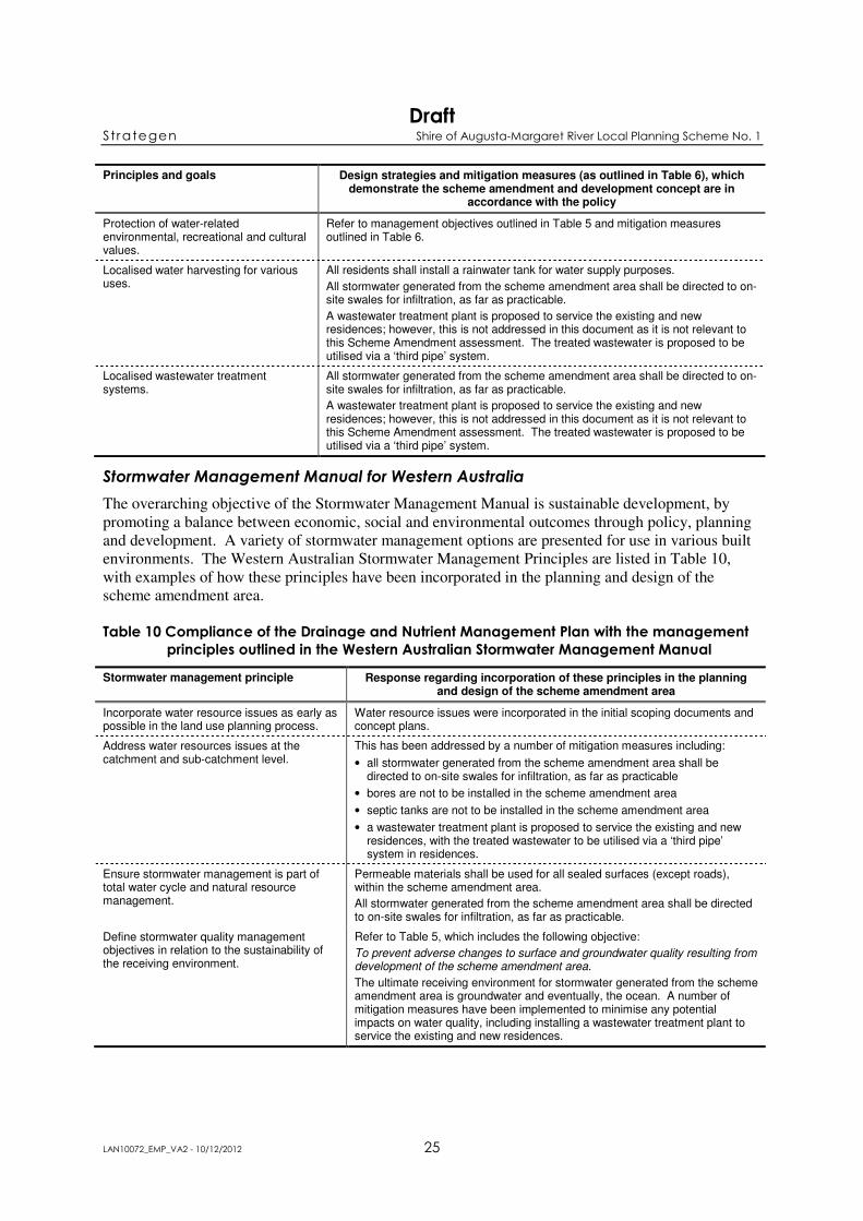
Principles and goals Design strategies and mitigation measures (as outlined in Table 6), which demonstrate the scheme amendment and development concept are in
accordance with the policy
Protection of water-related environmental, recreational and cultural values.
Refer to management objectives outlined in Table 5 and mitigation measures outlined in Table 6.
Localised water harvesting for various uses.
All residents shall install a rainwater tank for water supply purposes.
All stormwater generated from the scheme amendment area shall be directed to on-site swales for infiltration, as far as practicable.
A wastewater treatment plant is proposed to service the existing and new residences; however, this is not addressed in this document as it is not relevant to this Scheme Amendment assessment. The treated wastewater is proposed to be utilised via a ‘third pipe’ system.
Localised wastewater treatment systems.
All stormwater generated from the scheme amendment area shall be directed to on-site swales for infiltration, as far as practicable.
A wastewater treatment plant is proposed to service the existing and new residences; however, this is not addressed in this document as it is not relevant to this Scheme Amendment assessment. The treated wastewater is proposed to be utilised via a ‘third pipe’ system.
Stormwater Management Manual for Western Australia
The overarching objective of the Stormwater Management Manual is sustainable development, by
promoting a balance between economic, social and environmental outcomes through policy, planning
and development. A variety of stormwater management options are presented for use in various built
environments. The Western Australian Stormwater Management Principles are listed in Table 10,
with examples of how these principles have been incorporated in the planning and design of the
scheme amendment area.
Table 10 Compliance of the Drainage and Nutrient Management Plan with the management
principles outlined in the Western Australian Stormwater Management Manual
Stormwater management principle Response regarding incorporation of these principles in the planning and design of the scheme amendment area
Incorporate water resource issues as early as possible in the land use planning process.
Water resource issues were incorporated in the initial scoping documents and concept plans.
Address water resources issues at the catchment and sub-catchment level.
This has been addressed by a number of mitigation measures including:
• all stormwater generated from the scheme amendment area shall be directed to on-site swales for infiltration, as far as practicable
• bores are not to be installed in the scheme amendment area
• septic tanks are not to be installed in the scheme amendment area
• a wastewater treatment plant is proposed to service the existing and new residences, with the treated wastewater to be utilised via a ‘third pipe’ system in residences.
Ensure stormwater management is part of total water cycle and natural resource management.
Permeable materials shall be used for all sealed surfaces (except roads), within the scheme amendment area.
All stormwater generated from the scheme amendment area shall be directed to on-site swales for infiltration, as far as practicable.
Define stormwater quality management objectives in relation to the sustainability of the receiving environment.
Refer to Table 5, which includes the following objective:
To prevent adverse changes to surface and groundwater quality resulting from development of the scheme amendment area.
The ultimate receiving environment for stormwater generated from the scheme amendment area is groundwater and eventually, the ocean. A number of mitigation measures have been implemented to minimise any potential impacts on water quality, including installing a wastewater treatment plant to service the existing and new residences.
Draft Strategen Shire of Augusta-Margaret River Local Planning Scheme No. 1
LAN10072_EMP_VA2 - 10/12/2012 26
Stormwater management principle Response regarding incorporation of these principles in the planning and design of the scheme amendment area
Determine stormwater management objectives through adequate and appropriate community consultation and involvement.
Refer to Table 5, which outlines the objectives, targets and key performance indicators for drainage and nutrient management. This EMP will be released, with the ER document, for public comment where submission may be received regarding the objectives for drainage and nutrient management.
Ensure stormwater management planning is precautionary, recognises inter-generational equity, conservation of biodiversity and ecological integrity.
All stormwater generated from the scheme amendment area shall be directed to on-site swales for infiltration, as far as practicable. This will facilitate achievement of the objective to minimise impacts on the existing hydrology of the area.
Recognise stormwater as a valuable resource and ensure its protection, conservation and reuse.
All stormwater generated from the scheme amendment area shall be directed to on-site swales for infiltration, as far as practicable. This will facilitate achievement of the objective to minimise impacts on the existing hydrology of the area.
Recognise the need for site-specific solutions and implement appropriate non-structural and structural solutions.
Refer to Table 6, which outlines numerous mitigation measures that are both structural and non-structural.
4.5 MONITORING ACTIONS
Table 11 provides monitoring actions to enable assessment of the effectiveness of the drainage and
nutrient management actions in place.
Table 11 Monitoring actions for drainage and nutrient management
Parameter Frequency Location Purpose Responsibility
Soil erosion Weekly during construction activities
Within scheme amendment area
To determine if soil erosion is occurring.
CECO*
Local native flora Immediately following any rehabilitation or landscaping work
Rehabilitated and landscaped areas within the scheme amendment area
To ensure local native flora species have been utilised.
LandCorp, CECO
Sediment accumulation in on-site swales
Every 2 years as a minimum
Swales within scheme amendment area
To assess whether swales require cleaning to maintain infiltration capacity.
Shire of Augusta-Margaret River
* CECO: Contractor Environmental Control Officer
4.6 CONTINGENCY ACTIONS
Table 12 identifies the appropriate contingency actions to be initiated in the event that the objectives
for drainage and nutrient management are not met.
Table 12 Contingency actions for drainage and nutrient management
Trigger Action Responsibility
Formation of rills, gullies, or other evidence of soil erosion.
1. Identify cause. CECO*during construction and for three months following completion of construction activities, then the Shire of Augusta-Margaret River
2. Investigate strategies to minimise water/wind exposure and increase landform stability.
3. Implement erosion management strategy.
4. Monitor success of remedy.
Hydrocarbon spill occurs during construction activities.
1. Implement hydrocarbon spill procedure to contain and remove any contaminated material as soon as possible.
CECO
2. Implement environmental incident procedure (see Section 12.2).
3. An Environmental Incident Report shall be completed.
* CECO: Contractor Environmental Control Officer

Draft Strategen Shire of Augusta-Margaret River Local Planning Scheme No. 1
LAN10072_EMP_VA2 - 10/12/2012 27
5. LEEUWIN-NATURALISTE NATIONAL PARK MANAGEMENT PLAN
5.1 DESCRIPTION
The Leeuwin-Naturaliste National Park was established in 1957. The National Park generally hugs
the coastline from Bunker Bay in the north to Augusta in the south, though some areas extend further
inland. The Leeuwin-Naturaliste National Park is classified as Category II under the IUCN’s World
Commission on Protected Areas.
5.2 ENVIRONMENTAL ASPECTS TO BE MANAGED
The following aspects of the scheme amendment area development and associated fire management
area have the potential to affect the Leeuwin-Naturaliste National Park:
• clearing will remove vegetation and may result in the loss of terrestrial fauna or lead to the
fragmentation or loss of connectivity of habitat
• human presence in the scheme amendment area will increase the risk of further land
disturbance resulting in degradation to vegetation and habitat, and will potentially increase risk
levels associated with weeds and bush fires. Human presence may also deter fauna from
residing in the vicinity of disturbance areas due to noise emissions and general human activity.
Habitation will increase the risk of introducing feral species (including domestic pets) which
may compete for habitat and food, and may also prey on native species. Increased human
presence may also improve surveillance of the surrounding area and deter unfavourable
activities
• vehicle movements during the construction period and associated with the long-term
establishment of development may increase fauna fatalities
• physical attributes of housing and associated significant infrastructure may obstruct or
change views of existing natural features considered aesthetically significant. The housing and
associated infrastructure may, in itself, be aesthetically displeasing.
Management of the potential impacts to visual amenity are discussed in Section 7.
5.3 ENVIRONMENTAL OBJECTIVES, TARGETS AND INDICATORS
The environmental objectives, targets and KPIs for the Leeuwin-Naturaliste National Park are detailed
in Table 13 below.
Table 13 Environmental objectives, targets and indicators for the Leeuwin-Naturaliste
National Park
Objective Target KPI
To ensure that clearing is as approved for the Scheme Amendment and as outlined in the Fire Management Plan.
No clearing or disturbance outside of pre-defined boundaries within the scheme amendment and fire management area, during construction.
Visual observations of clearing operations.
Environmental Incident Reports.
To maintain and enhance ecological linkages within the fire management area.
Rehabilitate an approximately 250 m long access track within the fire management area, to a condition comparable to the surrounding vegetation.
Site inspections.
Rehabilitation monitoring results.
Minimise disturbance of the Leeuwin-Naturaliste National Park.
No direct pedestrian access-ways shall be created from the development to the Leeuwin-Naturaliste National Park, unless otherwise agreed with DEC.
Site inspections.
Evidence of agreement with DEC, if access-ways are present.

Draft Strategen Shire of Augusta-Margaret River Local Planning Scheme No. 1
LAN10072_EMP_VA2 - 10/12/2012 28
5.4 MITIGATION MEASURES
Specific mitigation measures have been identified to assist in achieving the Leeuwin-Naturaliste
National Park objectives (Table 14).
Table 14 Mitigation measures for the Leeuwin-Naturaliste National Park
Activity/ Parameter
Action Timing Responsibility
Induction Implement an induction program for construction personnel which contains information on:
• importance of the Leeuwin-Naturaliste National Park
• the requirement to stay within clearing boundaries
• hygiene measures (specifically for dieback and weeds)
• potential for site activities to affect fauna and fauna habitat
• avoidance of important fauna habitat where practicable (e.g. Banksia sessilis var. cordata and Agonis flexuosa)
• fauna encounter procedures.
Prior to clearing or earthworks commencing
CECO
Hygiene Establish hygiene management station/s at the designated entry and exit sites of the scheme amendment area, on designated roads or access tracks.
Prior to clearing or earthworks commencing; During construction
CECO
Clean earth-moving machinery of soil and vegetation, at the hygiene management station/s, prior to entering and leaving the scheme amendment area.
During clearing or earthworks activities
CECO
Prevent weed or dieback-affected road building materials, mulch or fill being brought into the scheme amendment area and rehabilitation area (~250 m of old firebreak).
Ongoing CECO, LandCorp
Restrict the movement of machines and other vehicles to the limits of the areas to be cleared.
During clearing and construction
CECO
No vegetation or soil from areas where Arum Lily is present, shall be utilised in rehabilitation or landscaping works.
Ongoing CECO, LandCorp
Clearing No clearing or disturbance outside of pre-defined boundaries within the scheme amendment and fire management area, during construction (see Figure 4).
During clearing and construction activities
CECO
Delineate the boundaries of the vegetation to be cleared in the field with flagging tape, signage or fencing.
Prohibit access beyond these boundaries.
During clearing and construction activities
CECO
Prune any overhanging vegetation on the clearing boundaries in preference to removing the trees/shrubs.
During clearing and construction activities
CECO
Vehicle movements
Restrict all vehicles to 40 km/hr within the scheme amendment area. Ongoing CECO and residents
Restrict movement of construction machinery and equipment to designated paths and roads.
During clearing and construction activities
CECO
Access Restrict access of construction personnel to designated paths and roads. During construction
CECO
No direct pedestrian access-ways shall be created from the development to the Leeuwin-Naturaliste National Park, unless otherwise agreed with DEC.
Ongoing LandCorp and Shire of Augusta-Margaret River

Draft Strategen Shire of Augusta-Margaret River Local Planning Scheme No. 1
LAN10072_EMP_VA2 - 10/12/2012 29
Activity/ Parameter
Action Timing Responsibility
Habitat Construct fencing along main roads to restrict and deter access to vegetated areas and minimise vehicle collisions with fauna.
As required during clearing and construction activities
CECO
Non-native animals
Install a dog fence between the interface of the scheme amendment area and future Leeuwin-Naturaliste National Park boundary to limit access by any dogs that may wander from residences within the scheme amendment area.
Prior to residents moving into the scheme amendment area
LandCorp
Feral animals Appropriately dispose of food scraps and other waste to sealed on-site waste disposal bins.
During construction
CECO
Rehabilitation and landscaping
Utilise only local native flora species in rehabilitation and landscaping activities within the scheme amendment area, including the public open space area. The species used shall include those species with known habitat/feeding value such as Parrotbush (Banksia sessilis var. cordata) and Peppermint (Agonis flexuosa).
Ongoing LandCorp, CECO and Shire of Augusta-Margaret River
Rehabilitate an approximately 250 m long access track within the fire management area (Figure 4), to a condition comparable to the surrounding vegetation.
Ongoing LandCorp
Weed control Implement a weed control program within the public open space area, and at the interface of the fire management area and Leeuwin-Naturaliste National Park.
Following completion of construction activities
Shire of Augusta-Margaret River
* CECO: Contractor Environmental Control Officer
5.4.1 Other benefits
A number of other initiatives will be implemented as part of the development of the scheme
amendment area, which will have positive outcomes for the Leeuwin-Naturaliste National Park:
• provision of an information package to landowners that:
• informs residents about the habitat value and the importance of complying with conditions
and management procedures, such as those on their lot titles and the relevant actions in this
EMP
• encourages the use of local native flora species in gardens, particularly those pre-existing
flora species and those with known habitat/feeding value such as Parrotbush (Banksia
sessilis var. cordata) and Peppermint (Agonis flexuosa).
• discourages interaction with, or feeding of, native animals or the undertaking of any other
activity that would otherwise encourage unnatural habits or dependencies
• discourages the keeping of cats.
• the Leeuwin-Naturaliste National Park will be extended to incorporate the remainder of the
vegetated Crown land of Lot 300 (approximately 231 ha), surrounding the scheme amendment
and fire management area
• financial support will be provided to the DEC to facilitate management of the Leeuwin-
Naturaliste National Park
• financial support will be provided to the Shire of Augusta-Margaret River to assist
implementation and maintenance of the Fire Management Plan.

Draft Strategen Shire of Augusta-Margaret River Local Planning Scheme No. 1
LAN10072_EMP_VA2 - 10/12/2012 30
5.5 MONITORING ACTIONS
Table 15 provides monitoring actions to enable assessment of the effectiveness of the Leeuwin-
Naturaliste National Park management actions in place.
Table 15 Monitoring actions for Leeuwin-Naturaliste National Park during construction
Parameter Frequency Location Purpose Responsibility
Flagging tape, signage or fencing
Daily throughout clearing and earthworks activities
Along clearing boundaries within scheme amendment and fire management area
To ensure that clearing boundaries are clearly marked.
To ensure no unauthorised clearing/access takes place beyond these boundaries.
CECO*
Hygiene Daily during construction activities
Hygiene station/s To ensure that all vehicles, construction machinery (including handheld tools), and footwear is subject to hygiene management procedures when entering and existing the scheme amendment area.
CECO
Rehabilitation Annually for two years
Old firebreak (~250 m long) To ensure the area is rehabilitated to a condition comparable to the surrounding vegetation.
LandCorp, then Shire of Augusta-Margaret River as part of fire management area monitoring
Dog fence Every two months once residents have moved into the scheme amendment area
Between the interface of the scheme amendment area and future Leeuwin-Naturaliste National Park boundary
To ensure the fence is intact and capable of limiting access to the Leeuwin-Naturaliste National Park by any dogs that may escape residences within the scheme amendment area.
Shire of Augusta-Margaret River
Fauna survey Two yrs after completion of construction activities within the scheme amendment area, and then another two years after that
Scheme amendment area and reference site (as in original Baseline/Level 2 survey)
To compare the occurrence of fauna to that which was recorded prior to development of the scheme amendment area.
LandCorp
* CECO: Contractor Environmental Control Officer
5.6 CONTINGENCY ACTIONS
Table 16 identifies the appropriate contingency actions to be initiated in the event that the objectives
for Leeuwin-Naturaliste National Park management are not met.
Table 16 Contingency actions for Leeuwin-Naturaliste National Park during construction
Trigger Action Responsibility
Unauthorised access beyond, or breach of pre-defined clearing boundaries.
1. Investigate cause. CECO*
2. Redefine boundaries if due to inadequate boundary marking.
3. Reinform all personnel of access restrictions beyond clearing boundaries.
4. If disturbance to vegetation requires mitigation, then the area disturbed shall be rehabilitated.
Draft Strategen Shire of Augusta-Margaret River Local Planning Scheme No. 1
LAN10072_EMP_VA2 - 10/12/2012 31
Trigger Action Responsibility
5. An Environmental Incident Report shall be completed.
Increase in feral animal abundance in the vicinity of the scheme amendment area.
1. Investigate cause. LandCorp then Shire of Augusta-Margaret River following two years after construction
2. Implement remedy, which may include re-educating residents regarding the importance of disposing of all food scraps in bins with secure lids.
3. Monitor success of remedy.
Direct pedestrian access-way created from the development to the Leeuwin-Naturaliste National Park, without agreement with DEC.
1. Investigate cause. LandCorp then Shire of Augusta-Margaret River following two years after construction as part of fire management area monitoring
2. Implement remedy, which may include:
• restricting access to the path by installing signage or fencing
• re-educating residents regarding the importance of minimising impacts on the Leeuwin-Naturaliste National Park
• rehabilitating access-ways.
3. Monitor success of remedy, ensuring access-way is no longer utilised.
* CECO: Contractor Environmental Control Officer
6. ABORIGINAL HERITAGE MANAGEMENT
6.1 DESCRIPTION
One registered Aboriginal site, DIA ID #21930 Gracetown Burial, Midden and Massacre Site lies
within the proposed residential development area. The site was previously identified in three studies
of the Gracetown region and identified by the Aboriginal heritage report (Fisher 2008) carried out for
the scheme amendment area. Whilst this area is considered of significant Aboriginal heritage value by
the authorised representative of the relevant Native Title claimants groups, Fisher (2008) states that
this recorded location may represent an amalgam of various components that may have already been
registered separately. Additionally, the coordinates are listed as ‘unreliable’ by the Department of
Indigenous Affairs (DIA).
The archaeological survey, carried out as part of the Aboriginal heritage report (Fisher 2008) also
identified a shell midden and some mounds, which may represent burial mounds located near the
football ground and not within the proposed residential development
Non-registered heritage sites (exact location undefined) have also been identified within the
Gracetown region, where artefactual material may exist below ground.
A more detailed description of the Aboriginal heritage of the scheme amendment area is contained in
Chapter 3, Section 5 of the ER.
6.2 ENVIRONMENTAL ASPECTS TO BE MANAGED
The following aspect of the scheme amendment area development has been identified as requiring
management to minimise effects on Aboriginal and cultural heritage values:
• earthworks and installation of infrastructure during construction may disturb known and/or
unknown heritage sites and affect ethnographic values.
6.3 ENVIRONMENTAL OBJECTIVES, TARGETS AND INDICATORS
The environmental objectives, targets and KPIs for Aboriginal heritage management are detailed in
Table 17 below.

Draft Strategen Shire of Augusta-Margaret River Local Planning Scheme No. 1
LAN10072_EMP_VA2 - 10/12/2012 32
Table 17 Environmental objectives, targets and indicators for Aboriginal heritage
Objective Target KPI
To manage Aboriginal heritage sites/artefacts in accordance with the requirements of the Aboriginal Heritage Act 1972 (Aboriginal Heritage Act).
No loss or damage to identified sites of Aboriginal heritage significance, unless in accordance with consent issued under Section 18 of the Aboriginal Heritage Act.
Environmental Incident Reports.
Section 18 approval.
No loss or damage to previously unrecorded sites of Aboriginal heritage significance, unless in accordance with consent issued under Section 18 of the Aboriginal Heritage Act.
Environmental Incident Reports.
Section 18 approval.
6.4 MITIGATION MEASURES
Specific mitigation measures have been identified to assist in achieving the Aboriginal heritage
objectives (Table 18).
Table 18 Mitigation measures for Aboriginal heritage during construction
Activity/Parameter Action Timing Responsibility
Planning Avoid disturbance to significant Aboriginal heritage sites, where practicable.
Prior to commencement of ground-disturbing activities
LandCorp
Where avoidance is not practicable, seek consent to disturb the site from the Minister for Indigenous Affairs through a Section 18 application under the Aboriginal Heritage Act 1972, in consultation with the Native Title holders.
Prior to commencement of ground-disturbing activities
LandCorp
Induction Implement an induction program for construction personnel which contains information on:
• obligations under the Aboriginal Heritage Act 1972
• requirements for the protection of known Aboriginal sites.
Prior to commencement of ground-disturbing activities
CECO*
Identified sites of Aboriginal heritage significance to be avoided (if any)
Flag and/or fence identified Aboriginal heritage sites to be avoided.
Ongoing CECO
Remove all flagging and/or fencing used to identify and protect Aboriginal heritage sites.
At the completion of construction activities
CECO
Clearing and earthworks
Qualified site heritage monitors and archaeologists (issued with a Section 16 permit) shall be on-site to monitor clearing and earthworks activities.
During clearing and earthworks
CECO, LandCorp
* CECO – Contractor Environmental Control Officer
6.5 MONITORING ACTIONS
Table 19 provides monitoring actions to enable assessment of the effectiveness of the Aboriginal
heritage management actions in place.
Table 19 Monitoring actions for Aboriginal heritage during construction
Parameter Frequency Location Purpose Responsibility
Flagging and/or fencing
Daily Within scheme amendment area
To ensure sites of Aboriginal heritage significance are adequately identified and protected.
CECO*
* CECO: Contractor Environmental Control Officer

Draft Strategen Shire of Augusta-Margaret River Local Planning Scheme No. 1
LAN10072_EMP_VA2 - 10/12/2012 33
6.6 CONTINGENCY ACTIONS
Table 20 identifies the appropriate contingency actions to be initiated in the event that the objectives
for Aboriginal heritage management are not met.
Table 20 Contingency actions for Aboriginal heritage during construction
Trigger Action Responsibility
Disturbance of an identified site of Aboriginal heritage significance.
1. Immediately cease all work in the area of the Aboriginal heritage site. CECO*
2. Investigate the cause of disturbance. CECO
3. Notify LandCorp of disturbance and its cause. CECO
4. If necessary, consult with relevant stakeholders (e.g. DIA) to determine actions required to restore the site to its original condition.
LandCorp
5. Implement actions to prevent disturbance from reoccurring (e.g. fencing site or re-informing workforce).
CECO
6. An Environmental Incident Report shall be completed. CECO
Previously unrecorded Aboriginal heritage site/artefact is uncovered or identified.
1. Immediately cease construction operations within 30 m of the potential heritage site.
CECO
2. Establish a 30 m buffer around the potential heritage site, outside which work may continue.
CECO
3. Notify LandCorp; who will then notify their appointed archaeologist and the DIA (if not already present). The police and State Coroner shall be contacted in the instance of the discovery of skeletal remains. If it is determined the remains are Aboriginal, the Commonwealth Minister for Aboriginal Affairs shall be notified (legal requirement under the Aboriginal and Torres Strait Islander Heritage Protection Act 1984 – Section 20(1)).
CECO, LandCorp
4. The authenticity of the site or material shall be determined using appropriate methods, in consultation with all relevant stakeholders, and suitable mitigation/management measures, once agreed upon by all stakeholders, shall be implemented as soon as practicable.
Where disturbance to the site cannot be avoided, consent to disturb the site shall be obtained under Section 18 of the Aboriginal Heritage Act.
Where disturbance to the site can be avoided (i.e. via reconfiguration of the development), actions may include compiling a detailed site record, collection of the cultural material or protection of the site (e.g. fencing).
LandCorp
5. Complete and forward a full report of the site/artefact to DIA within seven days of discovery.
LandCorp
6. An Environmental Incident Report shall be completed. CECO
* CECO: Contractor Environmental Control Officer
Draft Strategen Shire of Augusta-Margaret River Local Planning Scheme No. 1
LAN10072_EMP_VA2 - 10/12/2012 34
7. VISUAL AMENITY
7.1 DESCRIPTION
The landscape values of the scheme amendment area were assessed by Ecoscape (2009) in terms of
their biophysical character and socio-cultural character. The surrounding area is characterised by the
steep natural topography with mostly unbroken ridgelines, crescent-shaped bay and the existing
Gracetown settlement.
Development of the scheme amendment area has the potential to affect the visual amenity of the area
by altering the landscape values of the site. The landscape values of the scheme amendment area may
be affected if the development significantly alters view (e.g. “skylining” of buildings above the natural
ridgeline where there wasn’t previously) or if the building design or materials are aesthetically
incompatible with the landscape values.
7.2 ENVIRONMENTAL ASPECTS TO BE MANAGED
The following aspects of the scheme amendment area development have been identified as requiring
management to ensure they do not adversely impact natural landscape values:
• Clearing vegetation will alter the appearance of the natural environment which may be visible
from identified significant sites
• Physical attributes of housing and associated significant infrastructure may obstruct or
change views of existing natural features considered aesthetically significant. The housing and
associated infrastructure may, in itself, be aesthetically displeasing.
The clearing of vegetation is covered in the Biodiversity Management Plan (Section 3).
7.3 ENVIRONMENTAL OBJECTIVES, TARGETS AND INDICATORS
The environmental objective for visual amenity is:
• to create a new built environment in harmony with the natural elements of the landscape.
7.4 MITIGATION MEASURES
Specific mitigation measures have been identified to assist in achieving the visual impact objective
(Table 21).
Table 21 Mitigation measures for visual amenity
Activity/ Parameter
Action Timing Responsibility
Planning and design
Develop design guidelines for built form that provide recommended architectural finishes to preserve the landscape values of the site.
During development of Structure Plan
LandCorp and Shire of Augusta-Margaret River
Minimise regrading of existing topography. Prior to construction LandCorp
Align roads on existing contours. Prior to construction LandCorp
Avoid interruption (‘skylining’ of houses) of the natural ridgeline. Prior to construction LandCorp
Connect the new development with the existing town through legible pedestrian access ways within public easements in Gracetown.
Prior to construction LandCorp

Draft Strategen Shire of Augusta-Margaret River Local Planning Scheme No. 1
LAN10072_EMP_VA2 - 10/12/2012 35
Activity/ Parameter
Action Timing Responsibility
Rehabilitation and landscaping
Rehabilitate and/or landscape disturbed areas that are not to be utilised post-construction.
Within three months following the completion of construction activities
LandCorp and CECO
Disposal of sale
Inform buyer of development restrictions by providing a copy of the design guidelines within each contract of sale.
Prior to Contract of Sale and in all marketing materials
LandCorp
Assess all development applications against the requirements outlined in the design guidelines.
Submission of development application
Shire of Augusta-Margaret River
* CECO: Contractor Environmental Control Officer (relates to clearing and earthworks contractor only)

Draft Strategen Shire of Augusta-Margaret River Local Planning Scheme No. 1
LAN10072_EMP_VA2 - 10/12/2012 36
8. WASTE MANAGEMENT
8.1 DESCRIPTION
Development of the scheme amendment area will generate waste both during construction (e.g.
building materials, fuel rags) and from habitation of the residential lots (e.g. general domestic waste).
Both waste streams have the potential to result in detrimental impacts on the environment and as such,
will require specific management.
8.2 ENVIRONMENTAL ASPECTS TO BE MANAGED
The following aspect of the scheme amendment area development has been identified as requiring
management to ensure that waste generation does not adversely impact environmental values:
• disposal of wastes generated during construction and by residential occupants.
8.3 ENVIRONMENTAL OBJECTIVES, TARGETS AND INDICATORS
The environmental objectives, targets and KPIs for waste management are detailed in Table 22 below.
Table 22 Environmental objectives, targets and indicators for waste
Objective Target KPI
Minimise pollution or environmental harm due to inappropriate disposal of waste.
No uncontained waste, rubbish or litter is found within the scheme amendment area during construction.
Environmental Incident Reports.
Monitoring/Inspection records.
No waste found within the scheme amendment area immediately following construction.
Monitoring/Inspection records.
A Waste Register is maintained during construction indicating waste categories, approximate volumes of waste, and location of disposal.
Waste Register.
8.4 MITIGATION MEASURES
Specific mitigation measures have been identified to assist in achieving the waste management
objectives (Table 23).
Table 23 Mitigation measures for waste
Activity/ Parameter
Action Timing Responsibility
Planning Develop waste management strategies for each waste stream based on the principles of reduce, reuse, recycle and appropriate disposal.
Prior to commencing any waste producing activities
CECO*
General Remove all waste from the scheme amendment area for reuse/recycling/ disposal.
During construction
CECO
Collect all waste and transport to appropriately licensed disposal sites. As required during construction
CECO
Strong emphasis shall be placed on housekeeping and cleanliness at the site.
During construction
CECO

Draft Strategen Shire of Augusta-Margaret River Local Planning Scheme No. 1
LAN10072_EMP_VA2 - 10/12/2012 37
Activity/ Parameter
Action Timing Responsibility
Provide and empty litter bins. During construction
CECO
Keep records of all waste removed from site. During construction
CECO
Ablution facilities
Provide temporary portable sanitary or ablution facilities on-site. During construction
CECO
Regularly clean and maintain ablution facilities. During construction
CECO
A licensed contractor shall remove septage collected within portable sanitary or ablution facilities and disposed of to a licensed facility.
As required during construction
CECO
Oil, solvents and chemicals
Servicing of vehicles shall not occur within the scheme amendment area. During construction
CECO
Collect waste oil, solvents and other toxic material, for off-site reuse, recycling, treatment or disposal.
During construction
CECO
Store chemical wastes, waste oils, solvents and other toxic material in appropriately bunded areas prior to off-site disposal.
During construction
CECO
Licensed carriers shall be used for off-site transport and disposal. As required during construction
CECO
Hygiene stations
Collect seed, soil and organic matter removed during clean-down activities in a sealed container for disposal.
As required during construction
CECO
Dispose of seed, soil and organic matter removed during clean-down activities at approved landfill facilities.
As required during construction
CECO
* CECO: Contractor Environmental Control Officer (relates to clearing and earthworks contractor only)
8.4.1 Conditions of occupation
The following condition will be placed upon residential lot titles:
• septic tanks are not to be installed in the scheme amendment area.
This condition will be highlighted to residents and tenants by provision of an information package, as
outlined below in Section 8.4.2. The Shire of Augusta-Margaret River will be responsible for rubbish
collection and disposal from the scheme amendment area.
8.4.2 Other benefits
A number of other initiatives will be implemented as part of the development of the scheme
amendment area, which will have positive outcomes for waste management, including provision of an
information package to landowners. The information package will inform residents about the area’s
environmental values and the importance of complying with conditions and management procedures,
such as those on their lot titles and the relevant actions of this EMP.
8.5 MONITORING ACTIONS
Table 24 provides monitoring actions to enable assessment of the effectiveness of the waste
management actions in place.

Draft Strategen Shire of Augusta-Margaret River Local Planning Scheme No. 1
LAN10072_EMP_VA2 - 10/12/2012 38
Table 24 Monitoring actions for waste during construction
Parameter Frequency Location Purpose Responsibility
Inspection (presence/occurrence of waste, ablution facilities)
Weekly Construction area within scheme amendment area
Ensure appropriate disposal of waste material.
CECO*
Record keeping/Waste Register
All inspections and waste disposal activities as they occur
Construction area within scheme amendment area
Ensure appropriate disposal of waste material.
CECO
* CECO: Contractor Environmental Control Officer
8.6 CONTINGENCY ACTIONS
Table 25 identifies the appropriate contingency actions to be initiated in the event that the objectives
for waste management are not met.
Table 25 Contingency actions for waste during construction
Trigger Action Responsibility
Uncontained waste found within scheme amendment area during construction activities or immediately following construction.
1. Investigate cause of uncontained waste. CECO*
2. Dispose of uncontained waste.
3. Implement appropriate remedial action, which may include:
• secure bin lids
• reiterate management actions at ‘toolbox’ meetings
• amend protocol to include additional management actions.
4. An Environmental Incident Report shall be completed (see Section 12.2).
Waste Register not being maintained during construction.
1. Investigate cause. CECO
2. Implement appropriate remedial action, which may include discussing the requirement with the waste disposal contractors.
3. An Environmental Incident Report shall be completed (see Section 12.2).
* CECO: Contractor Environmental Control Officer
Draft Strategen Shire of Augusta-Margaret River Local Planning Scheme No. 1
LAN10072_EMP_VA2 - 10/12/2012 39
9. SOIL CONTAMINATION MANAGEMENT
9.1 DESCRIPTION
Development of the scheme amendment area may expose potential soil contaminants during the
planning and construction phase including asbestos. A baseline contamination investigation of the
scheme amendment area has been conducted and evidence of fly tipping has been identified in the
northwest corner of the scheme amendment area containing some small pieces of asbestos cement
(GHD 2009).
The presence of soil contaminants has the potential to present an environmental and/or human health
risk in the immediate area and potentially to neighbouring properties if the contaminants spread which
will greatly increase the cost of investigation and remediation. The Contaminated Sites Act 2003
(Contaminated Sites Act) is the main mechanism for identifying and managing known and suspected
contaminated sites. The Contaminated Sites Act requires owners or occupiers of a site, such as the
scheme amendment area, to report known or suspected contaminated sites to the DEC.
Prior to construction of the proposed residential development, investigations will be conducted in the
area identified as receiving fly tipping in accordance with the Guidelines for the Assessment,
Remediation and Management of Asbestos Contaminated Sites in Western Australia (DoH 2009) and
the DEC Contaminated Sites Management Series Guidelines to assess the degree of soil contamination
and recommend appropriate remediation actions (if required).
9.2 ENVIRONMENTAL ASPECTS TO BE MANAGED
The following aspects of the scheme amendment area development have been identified as requiring
management to ensure the development does not pose a health related and/or environmental risk due
to the presence of soil contaminants:
• site clearing and earthworks to level-off certain areas of the site for later residential
construction
• disposal of waste during the construction phase of the scheme amendment area development
Site clearing and earthworks may expose potential soil contaminations at levels that exceed
contamination guideline levels and require remediation measures to prevent further health related
and/or environmental impacts. Disposal of waste during the construction of the development has the
potential to contaminate the site unless disposed of appropriately.
9.3 ENVIRONMENTAL OBJECTIVES, TARGETS AND INDICATORS
The environmental objectives, targets and KPIs for soil contamination management are detailed in
Table 26 below.
Table 26 Environmental objectives, targets and indicators for soil contamination
management
Objective Target KPI
To prevent adverse health related and/or environmental impacts to construction personnel and future residents from soil contamination resulting from development of the scheme amendment area.
No identification and/or contribution of soil contaminants (waste) during construction activities.
Pre-clearing investigation report
Monitoring records.
Environmental Incident Reports.
No hydrocarbon spills to occur within the scheme amendment area during construction activities.
Environmental Incident Reports.

Draft Strategen Shire of Augusta-Margaret River Local Planning Scheme No. 1
LAN10072_EMP_VA2 - 10/12/2012 40
Objective Target KPI
Minimise impacts on the existing hydrology of the area.
On-site infiltration of all stormwater generated from the scheme amendment area, as far as practicable.
Infiltration swales within scheme amendment area.
Minimise pollution or environmental harm due to inappropriate disposal of waste.
No uncontained waste, rubbish or litter is found within the scheme amendment area during construction.
Environmental Incident Reports.
Monitoring/Inspection records.
No waste found within the scheme amendment area immediately following construction.
Monitoring/Inspection records.
A Waste Register is maintained during construction indicating waste categories, approximate volumes of waste, and location of disposal.
Waste Register.
9.4 MITIGATION MEASURES
Specific mitigation measures have been identified to assist in achieving the soil contamination
management objectives (Table 27). For all waste and drainage and nutrient management mitigation
measures applicable to soil contamination management refer to the mitigation measures outlined in the
Waste Management Plan (Section 8) and Drainage and Nutrient Management Plan (Section 4)
respectively.
Table 27 Mitigation measures for soil contamination management
Activity/ Parameter
Action Timing Responsibility
Planning Conduct investigations to assess the degree of existing soil contamination within the scheme amendment area and recommend appropriate remediation actions (if required).
Prior to any clearing and construction activities commencing
LandCorp, future developer
Induction Implement an induction program for construction personnel which contains information on:
• local hydrogeology
• spill procedures
• identification of potential soil contaminants
• waste management.
Prior to any clearing and construction activities commencing
CECO*
Earthworks and construction activities
No earthworks and other construction activities to continue in immediate vicinity of contaminated area until remediated appropriate or determined to be safe by the OH&S officer and it is determined that activities will not cause the contamination to spread.
i.e. removal of asbestos containing material (ACM)
Once soil contaminant is identified during construction activities
CECO,
Drainage and Nutrient Management (including hydrocarbons)
Refer to mitigation measures outlined in the Drainage and Nutrient Management Plan (Section 4).
Ongoing LandCorp, future developer, CECO, Shire of Augusta-Margaret River
Waste Refer to mitigation measures outlined in the Waste Management Plan (Section 8).
Ongoing CECO
Remediation If required, remediate the contaminated site in accordance with the Guidelines for the Assessment, Remediation and Management of Asbestos Contaminated Sites in Western Australia (DoH 2009) and the DEC Contaminated Sites Management Series Guidelines.
Pre-construction phase
LandCorp, future developer
Construction phase CECO, future developer
Post-construction phase
Future developer, Shire of Augusta-Margaret River

Draft Strategen Shire of Augusta-Margaret River Local Planning Scheme No. 1
LAN10072_EMP_VA2 - 10/12/2012 41
* CECO: Contractor Environmental Control Officer
9.5 MONITORING ACTIONS
Table 28 provides monitoring actions to enable assessment of the effectiveness of the soil
contamination management actions in place.
Table 28 Monitoring actions for soil contamination
Parameter Frequency Location Purpose Responsibility
Inspection (presence/occurrence of waste, ablution facilities)
Weekly Construction area within scheme amendment area
Ensure appropriate disposal of waste material.
CECO*
Record keeping/Waste Register
All inspections and waste disposal activities as they occur
Construction area within scheme amendment area
Ensure appropriate disposal of waste material.
CECO
Validation of appropriate remediation measures
Following remedial work (if required)
Identified contaminated site
To ensure effective remediation and removal of contaminated site classification
LandCorp, future developer and/or Shire of Augusta-Margaret River
* CECO: Contractor Environmental Control Officer
9.6 CONTINGENCY ACTIONS
Table 29 identifies the appropriate contingency actions to be initiated in the event that the objectives
for soil contamination management are not met.
Table 29 Contingency actions for soil contamination
Trigger Action Responsibility
Soil contaminant found during site contamination investigation prior to construction.
1. Investigate cause of site contamination. LandCorp
2. Delineate extent of soil contamination.
3. Implement appropriate remedial action.
4. Provide report to DEC, and DoH if ACM identified, in accordance with DEC Contaminated Sites Management Series Guidelines and Guidelines for the Assessment, Remediation and Management of Asbestos Contaminated Sites in Western Australia (DoH 2009).
Soil contaminant found during construction phase
1. Follow steps 1 – 3 above CECO*, LandCorp, future developer
2. An Environmental Incident Report shall be completed (see Section 12.2).
3. Provide report to DEC, and DoH if ACM identified, in accordance with DEC Contaminated Sites Management Series Guidelines and Guidelines for the Assessment, Remediation and Management of Asbestos Contaminated Sites in Western Australia (DoH 2009).
Hydrocarbon spill occurs during construction activities.
1. Implement hydrocarbon spill procedure to contain and remove any contaminated material as soon as possible.
CECO
2. Implement environmental incident procedure (see Section 12.2).
3. An Environmental Incident Report shall be completed.
Waste Refer to mitigation measures outlined in the Waste Management Plan (Section 8).
CECO
* CECO: Contractor Environmental Control Officer
Draft Strategen Shire of Augusta-Margaret River Local Planning Scheme No. 1
LAN10072_EMP_VA2 - 10/12/2012 42
10. DUST MANAGEMENT
10.1 DESCRIPTION
Construction activities, such as clearing and earthworks, and general vehicle movements on unsealed
roads in and around the scheme amendment area are likely to increase the risk of atmospheric dust
emissions. These emissions may result in off-site environmental impacts and public concern,
particularly when activities are undertaken close to residences (in some cases it will be adjacent to
existing houses along Langley Crescent). Dust also has the potential to smother vegetation close to
the dust source and irritate fauna.
The majority of the airborne particles associated with dust emissions from construction activities are
likely to be larger than PM10 and are associated with nuisance rather than public health problems.
Furthermore, the larger particles tend to settle back to the ground within a short range (<300 m) from
the source, thereby reducing the potential impact.
The risk of activities resulting in off-site dust emissions is generally dependent on:
• the frequency at which a dust generating activity takes place
• meteorological conditions, such as wind speed and direction
• composition of dust, including particle size distribution, particle density and moisture content
• the condition of the source.
10.2 ENVIRONMENTAL ASPECTS TO BE MANAGED
The following aspects of the scheme amendment area development have been identified as requiring
management to ensure dust emissions do not affect the amenity of nearby dust-sensitive premises:
• physical disturbance of the land surface during clearing and earthworks
• vehicle movement on unsealed roads and movement of heavy vehicles with uncovered loads
• wind erosion of dry exposed surfaces such as cleared areas prior to the establishment of housing
and ground cover.
10.3 ENVIRONMENTAL OBJECTIVES, TARGETS AND INDICATORS
The environmental objectives, targets and KPIs for dust management are detailed in Table 30 below.
Table 30 Environmental objectives, targets and indicators for dust
Objective Target KPI
To minimise the effect of dust generated by construction activities on the amenity of nearby residents.
No public complaints relating to dust generated during construction activities.
No obvious and unacceptable deposition observed off-site.
Number of dust-related public complaints received.
Visual observations of dust generation and deposition.
Minimise the effect of dust generated by construction activities on immediately adjacent vegetated areas.
No dust-related impact to vegetation outside the scheme amendment and fire management area caused by construction activities.
Vegetation monitoring.
10.4 MITIGATION MEASURES
Specific mitigation measures have been identified to assist in achieving the dust management
objectives (Table 31).
Draft Strategen Shire of Augusta-Margaret River Local Planning Scheme No. 1
LAN10072_EMP_VA2 - 10/12/2012 43
Table 31 Mitigation measures for dust during construction
Activity/Parameter Action Timing Responsibility
Induction Implement an induction program for construction personnel which contains information on:
• dust management measures implemented on-site
• vehicle speed limits enforced on-site
• potential for dust to affect vegetation and be a nuisance to nearby residences.
Prior to any construction activities commencing
CECO*
Consultation Advertise (in the local paper), and prepare and distribute a flyer to all residences in Gracetown advising:
• the construction commencement date
• staging of construction of the scheme amendment area
• the likely duration
• potential impacts
• mitigation measures being implemented to reduce impacts.
At least 48 hrs prior to any construction activities commencing
LandCorp
Clearing and earthworks
Clearing and earthworks shall not be undertaken during unfavourable weather conditions (e.g. high wind speed under dry conditions) and wind direction towards the existing Gracetown townsite.
During construction
CECO, CS/F**
Clearing in the scheme amendment area shall be kept to that required for immediate construction of residences and infrastructure.
During construction
CECO
Dust suppression measures
Wet down dust-prone unsealed surfaces, such as cleared lots and access roads, using a water cart.
During construction g
CECO
Vehicle movement Restrict vehicles to designated roads and access tracks. During construction
CECO
Observe on-site vehicle speed limits to reduce dust lift-off from unsealed roads.
During construction
All construction personnel
Cover (i.e. with tarps) all trucks transporting dusty materials. During construction
CECO
Public complaints Record all public complaints relating to dust in the Public Complaint Register System and inform CECO.
As required during construction
Any construction personnel that receive complaints
Rehabilitation Rehabilitate disturbed areas that will not be utilised post-construction, as soon as possible.
During and immediately following construction
LandCorp, CECO
* CECO: Contractor Environmental Control Officer
** CS/F: Contractor Supervisor/Foreman
10.5 MONITORING ACTIONS
Table 32 provides monitoring actions to enable assessment of the effectiveness of the dust
management actions in place.
Table 32 Monitoring actions for dust during construction
Parameter Frequency Location Purpose Responsibility
Visible dust emissions Daily Scheme amendment area and boundary
To monitor dust generation and deposition, and determine if dust suppression is required.
CECO*
Visible dust on vegetation
Weekly Vegetation within the scheme amendment and fire management area, and adjoining vegetated areas
To identify occurrence of dust on vegetation.
CECO

Draft Strategen Shire of Augusta-Margaret River Local Planning Scheme No. 1
LAN10072_EMP_VA2 - 10/12/2012 44
* CECO: Contractor Environmental Control Officer
10.6 CONTINGENCY ACTIONS
Table 33 identifies the appropriate contingency actions to be initiated in the event that the objectives
for dust management are not met. The Contractor Environmental Control Officer shall be responsible
for implementation of contingency actions, where necessary.
Table 33 Contingency actions for dust
Trigger Action Responsibility
Visual observations indicate obvious drift of dust emissions off-site.
1. Investigate cause. CECO*
2. Implement additional, appropriate dust control measures, which may include:
• application of chemical dust stabilisers, tarps or geo-textile materials
• temporarily ceasing construction activities that are generating dust.
3. An Environmental Incident Report shall be completed (see Section 12.2).
Excessive amount of dust accumulated on vegetation immediately adjacent to the scheme amendment and fire management area.
1. Investigate cause. CECO
2. Undertake immediate remedial action, which may include hosing or dusting-off vegetation.
3. An environmental Incident Report shall be completed (see Section 12.2).
Public complaint received relating to dust emissions from construction activities.
1. The complaint shall be recorded in the Public Complaint Register System and managed in accordance with the Public Complaint Resolution procedures (Section12.3).
Any construction personnel that receive complaints and CECO
* CECO: Contractor Environmental Control Officer

Draft Strategen Shire of Augusta-Margaret River Local Planning Scheme No. 1
LAN10072_EMP_VA2 - 10/12/2012 45
11. NOISE MANAGEMENT
11.1 DESCRIPTION
Noise has the potential to be of nuisance to nearby residents; the closest residences being those
adjacent to Langley Crescent which is the northern boundary of the scheme amendment area. Noise
will be generated by activities associated with clearing and earthworks, as well as construction of
residences within the scheme amendment area. Noise from these activities at sensitive receptors can
be further exacerbated by certain meteorological conditions, such as atmospheric temperature
inversions and the speed and direction of wind.
The assigned noise levels in the Environmental Protection (Noise) Regulations 1997 (Noise
Regulations) do not apply to construction activities carried out between 0700 and 1900 hours on any
day except Sunday and public holidays provided:
• construction work is carried out in accordance with Section 6 of the Australian Standard 2436-
1981 “Guide to Noise Control on Construction, Maintenance and Demolition Sites”
• the equipment used is the quietest reasonably available
• the CEO of the Shire of Augusta-Margaret River may request that a Noise Management Plan be
submitted for the construction work at any time.
Activities outside normal working hours (0700 and 1900 hours on any day except Sunday and public
holidays) will be undertaken in accordance with the a Noise Management Plan approved by the Chief
Executive Officer or delegate (in this case the Shire of Augusta-Margaret River).
11.2 ENVIRONMENTAL ASPECTS TO BE MANAGED
The following aspects of the scheme amendment area development have been identified as requiring
management to ensure noise emissions from the development do not affect the amenity of nearby
noise-sensitive premises:
• site clearing and earthworks to level-off certain areas of the site for later residential
construction
• construction of residences including minor excavation for foundations and transport of
materials.
Construction activities may result in minor increases in traffic noise on roads leading to the scheme
amendment area, and may cause localised temporary disruption to fauna in areas adjacent to the site.
However, increased noise emissions will be temporary.
11.3 ENVIRONMENTAL OBJECTIVES, TARGETS AND INDICATORS
The environmental objectives, targets and KPIs for noise management are detailed in Table 34 below.
Table 34 Environmental objectives, targets and indicators for noise
Objective Target KPI
To minimise the impact of noise emissions from construction activities on noise-sensitive premises.
No public complaints relating to noise, during construction activities.
Number of noise-related public complaints received.
Draft Strategen Shire of Augusta-Margaret River Local Planning Scheme No. 1
LAN10072_EMP_VA2 - 10/12/2012 46
Objective Target KPI
To ensure noise levels associated with development comply with the Noise Regulations.
Construction activities shall occur between the hours of 0700 and 1900 Monday to Saturday inclusive (except public holidays).
Timing of construction activities – log records.
11.4 MITIGATION MEASURES
Specific mitigation measures have been identified to assist in achieving the noise management
objectives (Table 35).
Table 35 Management actions for noise during construction
Activity/Parameter Action Timing Responsibility
Induction Implement an induction program for construction personnel which contains information on:
• the potential nuisance to neighbours of noise
• management measures to reduce noise nuisance.
Prior to any construction activities commencing
CECO*
Consultation Advertise (in the local paper), and prepare and distribute a flyer to all residences in Gracetown advising:
• the construction commencement date
• staging of construction of the scheme amendment area
• the likely duration
• potential impacts
• mitigation measures being implemented to reduce impacts.
At least 48 hrs prior to any construction activities commencing
LandCorp
Planning Construction activities shall occur between the hours of 0700 and 1900 Monday to Saturday inclusive (except public holidays).
During construction
CECO
Contractor facilities Locate semi-fixed noise generating equipment (e.g. generators, compressors) as far as practicable from surrounding premises.
During construction
CECO
Clearing and earthworks
Regularly inspect and maintain (where required) noise control equipment to ensure good working order.
During construction
CECO
Observe on-site vehicle speed limits to reduce dust lift-off from unsealed roads.
During construction
All construction personnel
Complaints register Record public complaints relating to noise in the Public Complaint Register System and inform CECO.
As required during construction
CECO
* CECO: Contractor Environmental Control Officer
11.5 MONITORING ACTIONS
Table 36 provides monitoring actions to enable assessment of the effectiveness of the noise
management actions in place.
Table 36 Monitoring actions for noise
Parameter Frequency Location Purpose Responsibility
Integrity of noise control equipment and practices
As part of construction site inspections
Entire construction site
To ensure noise control measures are in good working order.
CECO*
* CECO: Contractor Environmental Control Officer
11.6 CONTINGENCY ACTIONS
Table 37 identifies the appropriate contingency actions to be initiated in the event that the objectives
for noise management are not met.

Draft Strategen Shire of Augusta-Margaret River Local Planning Scheme No. 1
LAN10072_EMP_VA2 - 10/12/2012 47
Table 37 Contingency actions for noise
Trigger Action Responsibility
Construction activities required to occur outside 0700 and 1900 Monday to Saturday inclusive, or on Sunday or a public holiday.
Unless the construction activities can comply with the assigned levels in the Noise Regulations, the following is required:
1. The work must be carried out in accordance with Section 6 of Australian Standard 2436-1981.
2. The equipment used must be the quietest reasonably available.
3. The builder must advise all nearby occupants of the work to be done at least 24 hours before it commences.
4. The builder must show that it was reasonably necessary for the work to be done out of hours.
5. The builder must submit to the Shire of Augusta-Margaret River, a Noise Management Plan at least seven days before the work starts, and the plan must be approved by the CEO. The Noise Management Plan must include details of:
• need for the work to be done out of hours
• types of activity which could generate excessive noise
• predictions of noise levels
• control measures for noise and vibration
• monitoring of noise and vibration
• complaint response.
CECO*
Reasonable public complaint received relating to noise emissions from construction activities.
1. The complaint shall be recorded in the Public Complaint Register System and managed in accordance with the Public Complaint Resolution procedures (Section12.3).
CECO*
* CECO: Contractor Environmental Control Officer

Draft Strategen Shire of Augusta-Margaret River Local Planning Scheme No. 1
LAN10072_EMP_VA2 - 10/12/2012 48
12. MANAGEMENT FRAMEWORK
12.1 COMMUNICATIONS AND TRAINING
12.1.1 Internal communications
Internal communication methods may include the following, as applicable:
• meetings
• project reports
• performance assessments reports
• notice boards
• on-site personnel inductions, training and toolbox sessions (as required)
• sub-contractor coordination meetings.
These mechanisms will be used to address concerns and questions raised by site personnel and discuss
any environmental incidents that may have occurred. In addition, these mechanisms will be used to
communicate any new environmental management procedures or information to ensure effective
implementation.
12.1.2 External communications
External communications may include the following, as applicable:
• meetings and correspondence with appropriate regulatory authorities and stakeholders
• discussions and consultation with adjoining landowners
• handling of, and responding to, complaints or requests (Section12.3)
See also Section 12.4 relating to the establishment of a Sustainability Review Committee and Design
and Sustainability Guidelines Audit Group.
12.1.3 Inductions and training
All employees shall receive suitable environmental awareness training, to ensure they are aware of
their responsibilities and are competent to carry out their work in an environmentally acceptable
manner. Environmental requirements shall be explained to all on-site personnel during a site
induction. Ongoing instruction shall be provided via toolbox meetings and the like. Inductions and
ongoing instruction shall be recorded.
The environmental induction will include the following items:
• explanation of the purpose and objectives of the EMP
• roles and functions of personnel on-site in relation to environmental management
• brief explanation of employee responsibilities under the environmental management actions
within this EMP
• potential consequences of departure from procedures
• emergency procedures and responses
• identification of their legal obligations.

Draft Strategen Shire of Augusta-Margaret River Local Planning Scheme No. 1
LAN10072_EMP_VA2 - 10/12/2012 49
12.2 ENVIRONMENTAL INCIDENT REPORTING
Environmental incidents are events or occurrences that result in, or have the potential to result in,
unacceptable impacts to the environment, for example unauthorised clearing of vegetation and
vehicles deviating from designated roads and access tracks.
Environmental incidents include any breaches or non-adherences to objectives and procedures
prescribed in this EMP and other environmental management procedures applied to the site by
LandCorp.
All incidents will be reported on an Environmental Incident Report form and/or registered in an
electronic database. Incidents will be tracked to ensure that the appropriate corrective actions and
measures are taken to prevent the incident from reoccurring. Environmental incidents will be
reviewed on a monthly and annual basis to determine incident trends. This will enable targeting of
areas that require further management and will assist in preventing future incidents.
Environmental incidents shall be assigned a level of severity. Levels are yet to be finalised, however,
proposed levels may be as follows:
LEVEL 1: Minor non-adherence to procedure and/or a negligible environmental impact.
LEVEL 2: Minor non-adherence to procedure and minor environmental impact that requires little
management to be rectified.
LEVEL 3: Moderate breach of procedure and/or an environmental impact that requires management/
mitigation to be rectified.
LEVEL 4: (Serious incident) Extreme breach of procedure and/or environmental impact that could
lead to a breach of environmental approval conditions.
The proposed procedures to follow in the event of an environmental incident are listed in Table 38 and
vary depending on the level of incident occurring.
Table 38 Proposed environmental incident procedures
Procedure Responsibility
1. The incident shall be reported to the Contractor Supervisor/Foreman or the Contractor Environmental Control Officer as soon as practical. Whichever of the two is notified first, shall contact the other.
Person responsible or first on the scene
2. The level of environmental incident shall be determined. This may be up/down graded later depending on further advice from LandCorp, its consultants or government agencies.
CECO*
3. LandCorp shall be advised within 24 hours of a Level 2 incident and as soon as practicable within four hours following a Level 3 or 4 incident.
CECO
4. For all incidents Level 2 or higher, all work activities directly causing an environmental incident shall be stopped immediately and correct work procedures adopted (as detailed in component management plan contingency actions).
All personnel
5. Measures to limit the impact of Level 4 incidents on the environment shall be implemented as soon as practicable.
CECO, LandCorp
6. An Environmental Incident Report shall be completed and forwarded to the Contractor Supervisor/Foreman and LandCorp for Incidents of Level 2 or higher.
CECO
7. For all incidents, the causes and effects of the incident and methods to prevent the incident from reoccurring shall be discussed and any recommendations to be documented in the Environmental Incident Report. These recommendations shall be implemented as soon as practicable.
CECO and all other Contractor personnel
8. Following Level 2, 3 and 4 incidents, LandCorp shall report the incident to the appropriate government authorities.
LandCorp

Draft Strategen Shire of Augusta-Margaret River Local Planning Scheme No. 1
LAN10072_EMP_VA2 - 10/12/2012 50
Procedure Responsibility
9. The Environmental Incident Report shall be ‘signed-off’. This shall follow agreement on new procedures to prevent reoccurrence of the incident and any further remedial action required to mitigate impacts to the satisfaction of LandCorp and any regulatory authorities that were involved.
CS/F**, CECO
10. Environmental Incident Reports shall be reviewed on a monthly and annual basis to identify any incident trends and manage environmental risk more effectively.
CECO, CS/F
* CECO: Contractor Environmental Control Officer
** CS/F: Contractor Supervisor/Foreman
12.3 PUBLIC COMPLAINT RESOLUTION
A Public Complaint Register System will be operated to maintain a system of records that provide full
documentation of complaint handling.
The following will be recorded in the event that a public complaint is received:
• the date and time of the complaint
• the name of the person who received/recorded the complaint
• the method by which the complaint was made (e.g. phone, letter)
• personal details of the complainant
• the nature of the complaint
• the action to be taken in relation to the complaint and the person/s responsible for taking that
action
• potential for environmental incident.
Following investigation of the complaint, the Public Complaint Register System will be updated to
include:
• an outline of the investigations undertaken
• the action taken in relation to the complaint (including supplementary monitoring and corrective
actions)
• the reason for any decisions of inaction
• time and date of follow-up contact and resolution with the complainant
• the nature of, and outcomes from, follow-up contact with the complainant
• environmental incident report number (if applicable)
• any other details relevant to the complaint.
If the investigation of a complaint concludes that the nature of the complaint justifies its inclusion as
an Environmental Incident, it will be promptly acted upon according to the procedure outlined in
Section 12.2.
12.4 STAKEHOLDER CONSULTATION
LandCorp will seek advice and comment from the Shire of Augusta-Margaret River and DEC during
the finalisation of the various components of this EMP. LandCorp will continue to consult with the

Draft Strategen Shire of Augusta-Margaret River Local Planning Scheme No. 1
LAN10072_EMP_VA2 - 10/12/2012 51
wider community regarding the development by providing information on their website and through
regular newsletters.
A Sustainability Review Committee and a Design and Sustainability Guidelines Audit Group will be
formed with a membership comprising community members, LandCorp and Shire of Augusta-
Margaret River representatives. The Committee will be responsible for:
• reviewing the effectiveness and relevance of the Design and Sustainability Guidelines and
implementation of the Sustainability Framework
• making recommendations to the Shire of Augusta-Margaret River for modification and
improvement, with particular reference to sustainability initiatives
• audit compliance with the fire management plan.
The Group will be responsible for:
• providing advice to prospective lot purchasers in respect to the Design and Sustainability
Guidelines
• assessing development applications for compliance with the Design and Sustainability
Guidelines, and providing the Shire of Augusta-Margaret River with an audit report.
The Committee and Group will provide another consultation avenue for the major stakeholders
associated with the residential development area.
12.5 AUDITING
LandCorp will conduct internal audits of its contractors to ensure compliance with the relevant scheme
conditions and implementation of the management actions outlined in this EMP, or other relevant
documents. The Shire of Augusta-Margaret River may also conduct audits to ensure development of
the scheme amendment area is in accordance with Local Planning Scheme No. 1 text.
Persons responsible for environmental auditing shall be suitably qualified (e.g. accredited under
Registrar Accreditation Board Society of Australasia [RABQSA]).
Where auditing finds particular environmental management actions are not effective, the audits may
recommend changes to procedures.
12.6 REVIEW AND REVISION
This EMP shall be reviewed as required throughout the duration of the development. Upon review,
the document shall be revised and re-issued where appropriate. In addition, continued improvement of
the plan will occur in response to environmental incident resolutions, audit findings, monitoring
results, continuous improvement and changes in regulatory and corporate requirements.
The Shire of Augusta-Margaret River will be advised of any minor changes to the plan and provided
with the revised document. Major changes will not be undertaken without consultation with the Shire
of Augusta-Margaret River and DEC (where necessary).

Draft Strategen Shire of Augusta-Margaret River Local Planning Scheme No. 1
LAN10072_EMP_VA2 - 10/12/2012 52
13. REFERENCES
Biota 2008, Gracetown Proposed Residential Development Preliminary Subterranean Fauna
Assessment, report prepared for LandCorp.
Department of Water (DoW) 2004, Stormwater Management Manual for Western Australia,
Department of Water, Perth, Western Australia.
Department of Agriculture and Food Western Australia (DAF) 2007, Declared Plants List, available
at: http://agspsrv34.agric.wa.gov.au/programs/app/dec_pl/declared plants.htm.
Department of Health (DoH) 2009, Guidelines for the Assessment, Remediation and Management of
Asbestos Contaminated Sites in Western Australia, Perth, Western Australia.
Ecoscape 2009, Gracetown Landscape Assessment Report: Landscape Visual Assessment and Site
Analysis, report prepared for LandCorp.
Environmental Protection Authority (EPA) 2005, Position Statement No. 8: Environmental Protection
in Natural Resource Management, EPA, Perth, Western Australia.
Environmental Protection Authority (EPA) 2008, Guidance Statement No. 33: Environmental
Guidance for Planning and Development, EPA, Perth, Western Australia.
GHD 2009, Gracetown Residential Development, Contamination Investigation, report prepared for
LandCorp.
Fisher 2008, Report of the Aboriginal heritage survey of the proposed LandCorp development at
Gracetown, Shire of Augusta-Margaret River, WA, report prepared for LandCorp.
FirePlan WA 2010, Fire Management Plan: Gracetown Residential Development, report prepared for
LandCorp.
Harewood G 2009, Gracetown Level 2 Fauna Survey, report prepared for Strategen.
Mattiske Consulting (Mattiske) 2006a, Flora and Vegetation on the Proposed Gracetown
Development Site, report prepared for Bowman Bishaw Gorham.
Mattiske Consulting (Mattiske) 2006b, Reassessment of the Botanical Values on the Proposed
Gracetown Development Site, report prepared for Strategen.
Mattiske Consulting (Mattiske) 2008, Reassessment of the Botanical Values on the Proposed
Gracetown Development Site, report prepared for Strategen.
Rooks D 2008, Flora survey for vegetation complex GE, Kr and KE.
Western Australian Herbarium 2006, Florabase, Department of Conservation and Land Management,
http://florabase.calm.wa.gov.au.
Western Australian Planning Commission (WAPC) 1998, Statement of Planning Policy No. 6.1
Leeuwin – Naturaliste Ridge Policy, prepared under section 5AA of the Town Planning and
Development Act 1928 (as amended in 2003), Western Australian Planning Commission,
http://ww.wapc.wa.gov.au/Publications/157.aspx [Accessed 12 December].
Western Australian Planning Commission (WAPC) 2003, State Planning Policy No. 2: Environment
and Natural Resources, Western Australian Planning Commission,
http://www.wapc.wa.gov.au/Publications/134.aspx [Accessed 12 December 2007].

Draft Strategen Shire of Augusta-Margaret River Local Planning Scheme No. 1
LAN10072_EMP_VA2 - 10/12/2012 53
Western Australian Planning Commission (WAPC) 2006, State Planning Policy No. 2.9: Water
Resources, Western Australian Planning Commission,
http://www.wapc.wa.gov.au/Publications/1281.aspx [Accessed 27 March 2008].
Western Wildlife 2007, Gracetown Development: A Fauna Assessment, report prepared for Strategen.


Appendix 1
Fire Management Plan
FirePlan WA (2010)


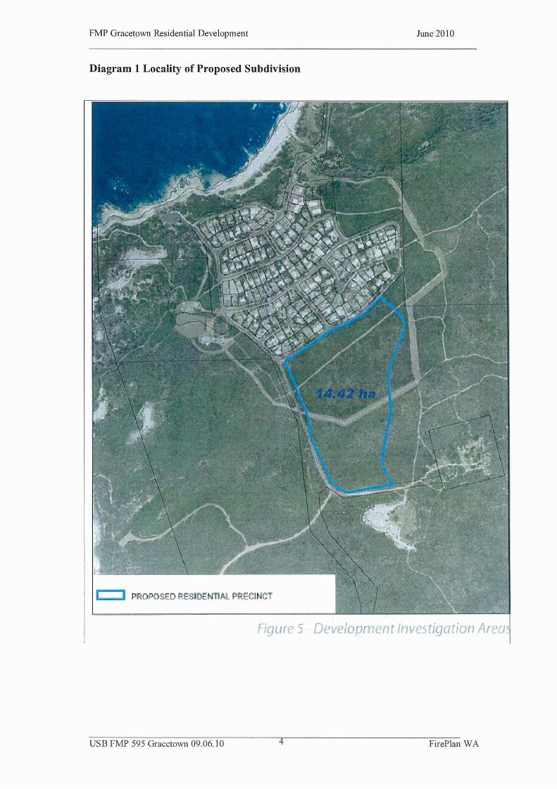

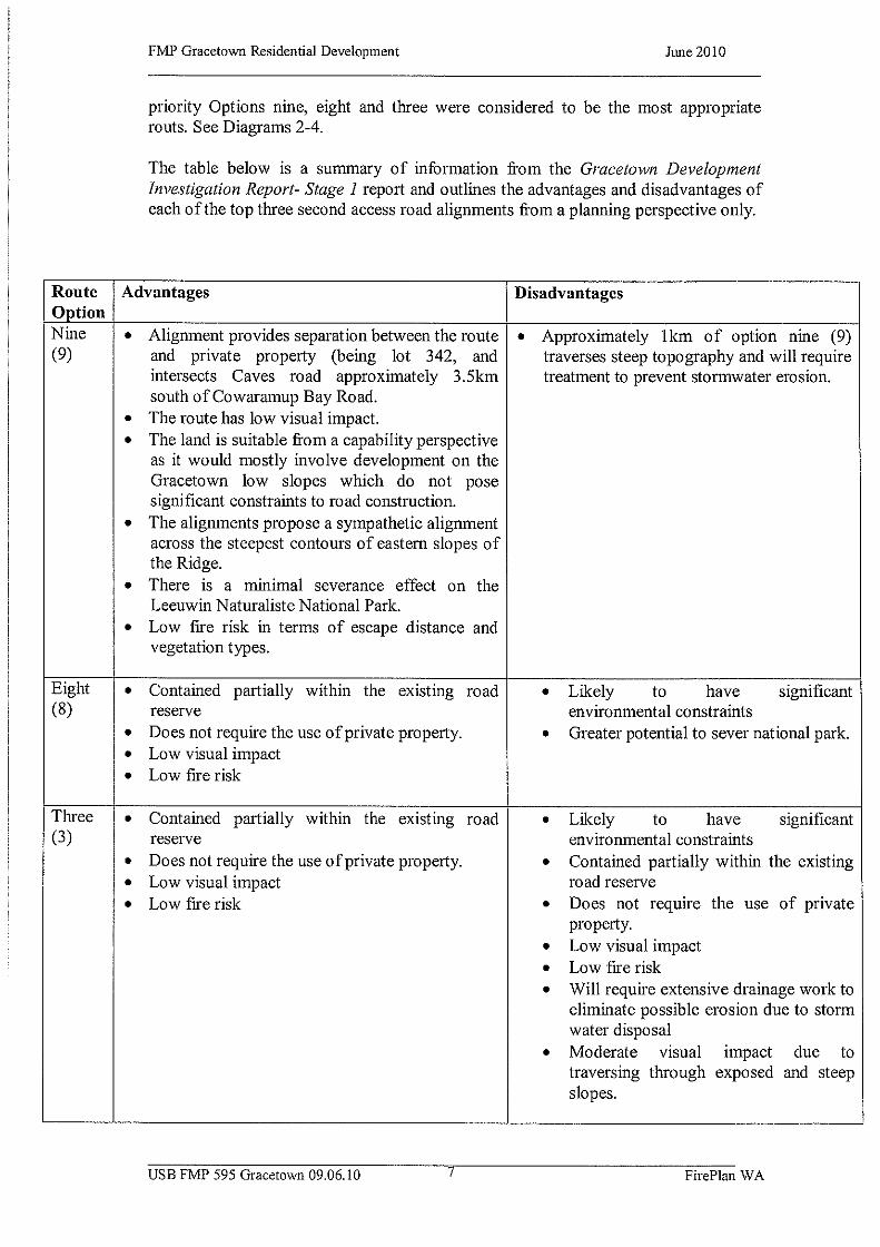


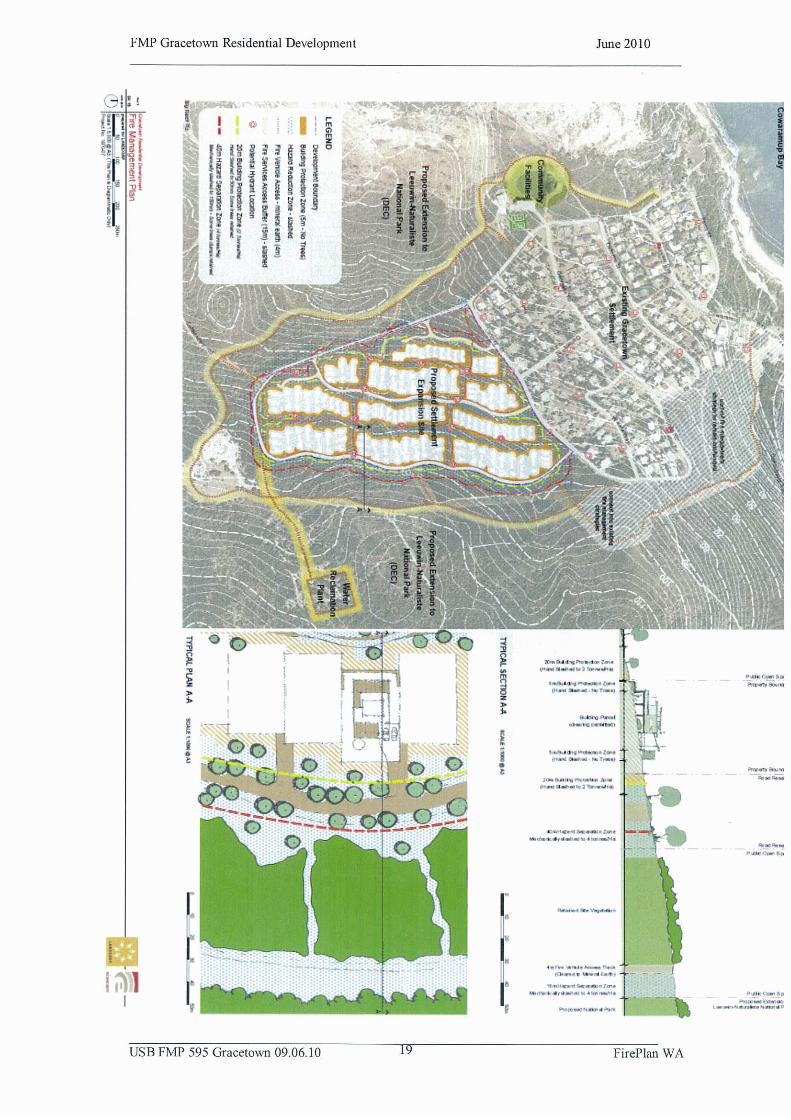


Appendix 2
Procedures to Minimise
Risk to Western Ringtail
Possums During
Vegetation Clearing
and Building Demolition
DEC (2010)

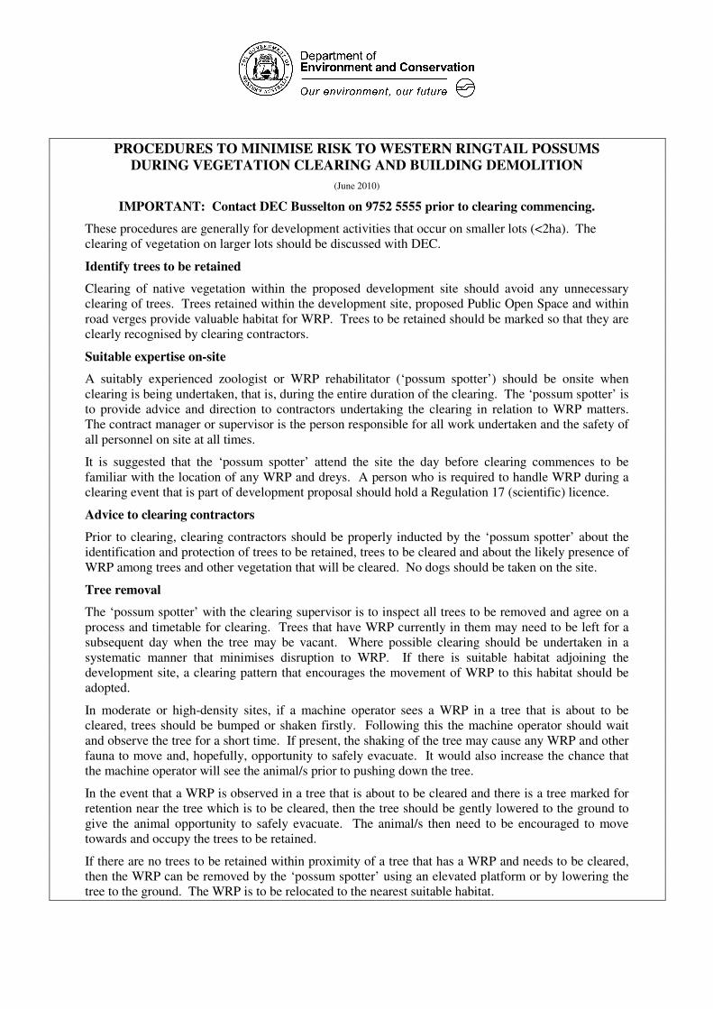
PROCEDURES TO MINIMISE RISK TO WESTERN RINGTAIL POSSUMS
DURING VEGETATION CLEARING AND BUILDING DEMOLITION
(June 2010)
IMPORTANT: Contact DEC Busselton on 9752 5555 prior to clearing commencing.
These procedures are generally for development activities that occur on smaller lots (<2ha). The
clearing of vegetation on larger lots should be discussed with DEC.
Identify trees to be retained
Clearing of native vegetation within the proposed development site should avoid any unnecessary
clearing of trees. Trees retained within the development site, proposed Public Open Space and within
road verges provide valuable habitat for WRP. Trees to be retained should be marked so that they are
clearly recognised by clearing contractors.
Suitable expertise on-site
A suitably experienced zoologist or WRP rehabilitator (‘possum spotter’) should be onsite when
clearing is being undertaken, that is, during the entire duration of the clearing. The ‘possum spotter’ is
to provide advice and direction to contractors undertaking the clearing in relation to WRP matters.
The contract manager or supervisor is the person responsible for all work undertaken and the safety of
all personnel on site at all times.
It is suggested that the ‘possum spotter’ attend the site the day before clearing commences to be
familiar with the location of any WRP and dreys. A person who is required to handle WRP during a
clearing event that is part of development proposal should hold a Regulation 17 (scientific) licence.
Advice to clearing contractors
Prior to clearing, clearing contractors should be properly inducted by the ‘possum spotter’ about the
identification and protection of trees to be retained, trees to be cleared and about the likely presence of
WRP among trees and other vegetation that will be cleared. No dogs should be taken on the site.
Tree removal
The ‘possum spotter’ with the clearing supervisor is to inspect all trees to be removed and agree on a
process and timetable for clearing. Trees that have WRP currently in them may need to be left for a
subsequent day when the tree may be vacant. Where possible clearing should be undertaken in a
systematic manner that minimises disruption to WRP. If there is suitable habitat adjoining the
development site, a clearing pattern that encourages the movement of WRP to this habitat should be
adopted.
In moderate or high-density sites, if a machine operator sees a WRP in a tree that is about to be
cleared, trees should be bumped or shaken firstly. Following this the machine operator should wait
and observe the tree for a short time. If present, the shaking of the tree may cause any WRP and other
fauna to move and, hopefully, opportunity to safely evacuate. It would also increase the chance that
the machine operator will see the animal/s prior to pushing down the tree.
In the event that a WRP is observed in a tree that is about to be cleared and there is a tree marked for
retention near the tree which is to be cleared, then the tree should be gently lowered to the ground to
give the animal opportunity to safely evacuate. The animal/s then need to be encouraged to move
towards and occupy the trees to be retained.
If there are no trees to be retained within proximity of a tree that has a WRP and needs to be cleared,
then the WRP can be removed by the ‘possum spotter’ using an elevated platform or by lowering the
tree to the ground. The WRP is to be relocated to the nearest suitable habitat.

Dreys should be inspected prior to clearing and possibly removed. Dreys that remain in the tree
during clearing have to be checked as soon as possible as baby WRP may remain in the drey.
Clearing should be undertaken on a face so as to drive WRP towards suitable habitat.
Services
The proponent will need to identify where underground services are to be installed and to ensure any
detrimental impact from these services is minimised.
Understorey vegetation
There will always be a possibility that WRP, Southern Brown Bandicoots, etc, will be found in under
and midstorey vegetation. Care needs to be taken when clearing this vegetation with a check to be
undertaken by foot prior to machines entering the areas and clearing this vegetation.
Injured WRP
If contractors encounter injured WRP during clearing operations, then the ‘possum spotter’ needs to be
notified immediately so that arrangements can be made for the welfare of the injured animal.
Stockpile practices
Contractors need to be made aware that displaced WRP may shelter within stockpiled vegetation.
Therefore, to minimise any accidental injury or death of WRP, personnel involved in the removal or
disposal of stockpiles need to be made aware of and be prepared for the potential presence of WRP. If
WRP are encountered then the Department needs to be immediately notified. Any dreys in fallen trees
are to be removed prior to stockpiling as WRP have been known to return to their dreys/trees.
The preference is that vegetation is not stockpiled but removed on the same day clearing occurs. If
vegetation is to be stockpiled on-site, then it is preferable to place it in cleared areas as far as possible
from retained remnant vegetation. Chipping of removed debris is to be undertaken away from retained
habitat to minimise the noise impacts on WRP.
In large clearing events where chipping will be undertaken over a number of days, it is preferred that
the chipper remains in one position and vegetation is brought to the chipper as opposed to the chipper
moving through the site. This is to consolidate the noise impacts in one area of the development site.
Buildings
Site workers are to be advised about the potential presence of WRP in derelict buildings and to stage
works to minimise potential injuries to WRP during demolition works. Prior to clearing works
commencing, the roof and ceilings on derelict buildings should be removed prior to demolition to
allow for dispersal of WRP. DEC should be immediately notified of any WRP that may be
inadvertently injured during demolition works.
There is a risk to WRP if rat or mouse baiting is undertaken prior to demolition. Appropriate methods
of baiting need to be engaged if rats or mice are to be controlled prior to demolition. One method is to
place the poison out of WRP reach, inside poly pipe secured to a beam in the roof space. The pipe
should be about 1m long and no greater than 50mm in diameter. Another method is to place a plastic
ice-cream container upside down over rate poison with small arches cut into the side of the container.
The arches should be a maximum height and width of about 50mm and the container secured to a
rafter.
Post Clearing Reporting
The proponent is to provide DEC with a report on the impact on WRP during the habitat removal
process within 28 days of completion of vegetation clearing or building demolition works.