Lake to Sound Trail Feasibility...
28
Lake to Sound Trail Lake to Sound Trail FEASIBILITY STUDY June 2009
Transcript of Lake to Sound Trail Feasibility...

L a k e t o S o u n d T r a i lL a k e t o S o u n d T r a i lFEASIBILIT Y STUDY
June 2009

Ack nowledgements
King County
City of Renton
City of Tukwila
City of SeaTac
City of Burien
City of Des Moines
Sound Transit
Washington State Department of Transportation
Cascade Bicycle Club

this page intentionally left blank

1
L a k e t o S o u n d T r a i l F e a s i b i l i t y S t u d y
Picture a route that connects the southern end of Lake Washington, where the Cedar River fl ows into the lake, to Puget Sound, a majestic body of water. Th is trail would connect the cities of Renton, Tukwila, SeaTac, Burien, and Des Moines, as well as the recreational, residential, retail, and employment areas within these cities.
Starting at the southern end of Lake Washington in Renton, the trail follows the existing Cedar River Trail south along the banks of the Cedar River into Cedar River Park. Th e trail meanders by the Renton Municipal Airport, with its long and proud heritage of serving planes inspired by Boeing’s top designers, and skirts the northern edge of the downtown district of Renton. Th e trail off ers excellent views of and access to the Cedar River. At the Cedar River Park, one can continue along the river to the City of Seattle’s Cedar River Watershed or turn west to follow the Lake to Sound Trail.
Continuing west into downtown Renton, the trail connects through Tonkin Park to the old Renton train station, which served the Spirit of Washington dinner train. At this point, the trail follows the railroad tracks, which provide sweeping regional views of Renton and eventually plunge into the forested canopy of the Black River Riparian Forest. Th is park is a wildlife refuge with a diverse and treasured ecosystem, off ering trail users wonderful separation from the urban landscape while still making the important connections among employment, retail, and residential areas.
Emerging from the Black River Riparian Forest, the trail connects under the Sounder Commuter rail line into the largest park in the city of Tukwila, Fort Dent Park, and connects to the Green River and Interurban trails. Traveling south along the Green River Trail, it ducks under Interurban Avenue S and heads into Tukwila Park, the City’s oldest park with its large fi rs and a variety of rhododendrons.
Traveling west, Southcenter Boulevard provides a gentle but steady climb to the Sound Transit link light rail station as the land rises up and connects into the city of SeaTac. Th e trail wraps around the northern edge of the Seattle-Tacoma (Sea-Tac) International Airport and connects to Des Moines Memorial Drive, which is a living memorial to those who gave their lives in the course of World War I. Th e trail continues south lined with American elm trees into the city of Burien and escapes the built-up areas as it settles into a green ribbon winding south along the SR 509 extension right of way. As the SR 509 extension heads east to connect to I-5, the trail turns south to connect into the city of Des Moines and the Des Moines Creek Trail. Hugging the side of a ravine, the trail follows the bubbling creek as it makes its way to the Des Moines Beach Park to arrive at its destination, Puget Sound.
Introduction - Painting the Picture of the Trail
Th e Lake to Sound Trail will be a legacy for our future generations. By connecting the trails in our region we are creating pathways for pedestrians and cyclists to enjoy access to our downtown, neighborhoods and parks, and to explore the natural beauty along the shores of our rivers.
—Renton City Councilmember Randy Corman

2
L a k e t o S o u n d T r a i l F e a s i b i l i t y S t u d y
Project Goals – What would make a successful Lake to
Sound Trail?
Th is study was commissioned to examine the feasibility, timeline, and routing for constructing a multi-purpose trail or similar facility from Lake Washington to Puget Sound through Renton, Tukwila, SeaTac, Des Moines, and Burien. To guide the process, the project team evaluated a range of alternative routes to meet several goals for the trail:
1. Develop a safe, continuous regional trail connecting Lake Washington from Renton to Puget Sound in Burien.
2. Serve local and regional nonmotorized transportation needs and provide access to the trail for local communities.
3. Evaluate opportunities to proceed with the development of selected sections of the trail by applying for upcoming federal transportation funding.
4. Provide economic and health benefi ts to communities along the trail.
Th e majority of the feasibility study focuses on determining a preferred alignment for a Lake to Sound Trail corridor. Characteristics such as cost and constraints were identifi ed based upon fi eld observations, consultation with local jurisdictions, and review of existing studies and analyses.
Benefi ts of the Lake to Sound Trail
Before addressing the feasibility of developing a regional trail, an overview of benefi ts of a trail is appropriate as a reminder of the potential positive outcomes from achieving the trail vision. Th e Lake to Sound Trail would benefi t people in local communities by providing an alternative to driving from one place to another, encouraging physical activity, helping children get safely to and from school, connecting to other trails and facilities, and creating a new community resource that has the potential to bring people together.
What is a regional trail?
A regional trail is a shared-use (multi-use), regionally signifi cant, off -road path that provides recreational opportunities and enhances regional mobility and travel. Th ese facilities meet regional trail development guidelines for size, grade, and other characteristics and are suitable for nonmotorized uses such as bicycling, hiking, jogging, roller-blading, roller-skating, and other similar activities.
In urban areas, regional trails may use streets as an interim solution, where providing separated, off -road paths is not possible. User safety and convenience are paramount for both off -road and on-road trails. Providing opportunities for travel by all age groups, user types, and skill levels is essential to these facilities.
King County currently is responsible for over 175 miles of regional trails throughout the county. Th ese trails are either paved or soft-surfaced (gravel). However, they all share common features of providing a safe and enjoyable experience for a variety of trail uses and levels.
For regional trails within the urban growth area, King County prefers a trail with a minimum width of 12 feet of pavement and 2-foot shoulders on both sides, separated from motorized facilities such as roads. However, in densely developed urban areas, opportunities to develop such a corridor may be limited. New trail alignments are often limited to circumstances where linear corridors already exist, such as the following:
• Linear utility corridors, such as those associated with transmission lines or pipelines, can often accommodate a trail. However, undeveloped utility corridors were not identifi ed within the Lake to Sound Trail study area, basedon a review of aerial photographs and parcels maps.
• Railroad corridors are attractive for trail use when they are constructed at grade, because they are built with a horizontal and vertical geometry that lends itself to trails. Rail corridors also often have fewer crossings and intersections than other types of corridors. However, for trail use rail companies must be agreeable to such an arrangement or have abandoned the corridor. If rail use remains along with a new trail, there must be adequate right of way to accommodate the negotiated separation between the tracks and the trail. One rail corridor has been identifi ed within the Lake to Sound Trail study area.
• Road rights of way may accommodate a variety of nonmotorized schemes that may include off -road two-way sidepaths located adjacent to the roadway, bike lanes and sidewalks on both sides of the road, wider paved shoulders (preferably on both sides), or shared uses with motor vehicles. Th e choice of facility type depends on the amount of right of way available, the number of driveways and roads crossed, and other safety factors. Numerous road corridors could become part of the Lake to Sound Trail alignment, although on-road segments would not meet regional trail development guidelines and, strictly speaking, would not be considered regional trails.
The Lake to Sound Trail will provide excellent opportunities to connect to existing trails like the Green River Trail shown above.

3
L a k e t o S o u n d T r a i l F e a s i b i l i t y S t u d y
How were alternatives for the Lake to Sound Trail
identifi ed?
Th e idea of developing trails through these municipalities is not new. We reviewed planning documents prepared by each of the jurisdictions and met with many of them to understand the perspectives and insights of each. Several overarching principles guided our eff orts:
• Where available, the preferred alternative would be a regional trail—a two-way, paved, multi-use path separated as much as possible from roadway traffi c and confl icts such as driveways. Where property ownership and cost could substantially delay development of a trail segment (10 years or more), however, we off ered shorter-term (i.e., interim) non-regional trail alternatives for consideration.
• Th e objective for shorter-term trail alternatives was to minimize the level of investment and potential known confl icts. Routes were selected that generally required less property confl icts, have a lower cost to construct, and would leave behind an inherent value to the nonmotorized network with the eventual construction of the preferred alignment.
• Preference was given to alignments where nonmotorized investments have already been made or are being made. In these areas, we typically proposed to maintain the same type of facility as is currently in place or being developed. By doing so, we help to minimize the cost impact and political backlash of rebuilding or redesigning an ‘improved’ area. In some instances, however, these investments may not meet the County’s guidelines for a regional trail at this time.
• We attempted to provide more continuity and consistency for trail users by minimizing the number of times a facility type is switched along a given segment. For example, we sought to minimize switching between off -road and on-road facilities.
In general, recommendations for potential alignments and facility types considered guidelines such as the King County Regional Trail System Development Guidelines, the Guide for the Development of Bicycle Facilities (AASHTO 1999), the Guide for the Planning, Design, and Operation of Pedestrian Facilities (AASHTO 2004) the Washington State Department of Transportation (WSDOT) Design Manual, and best professional judgment based on what we have seen work in other locations.
Feasibility Summary
Is it feasible to build a trail from Lake Washington to Puget Sound, connecting through Renton to Burien? Yes. However, there are some signifi cant challenges to address and diff erences in the readiness of segments to be constructed. As we identifi ed and evaluated alignments and layouts, we considered the six criteria described below. Where constraints could potentially be addressed through the future design phase, we identifi ed some of the options.
1. Continuous route and right of way with a common trail treatment increases the ability of users to follow the trail. It also reduces the likelihood of confl ict, such as wrong-way cycling when a sidepath confi guration switches to bike lanes and sidewalks (i.e., bicyclists do not cross the street to ride in the direction of traffi c). However, natural and man-made barriers often constrain the continuous route and right of way. To a certain extent, these constraints can be addressed through the design process, though sometimes at substantial cost. For example, to create a safer, controlled interaction, bridges could carry users over obstacles such as roadways and rivers, boardwalks could navigate wet areas, and tunnels could cross under railroad tracks.
2. Safety is paramount. Trail facilities either on-road or off -road should provide an environment with reduced chance of confusion and confl icts among all users. Diffi cult and narrow sections should be avoided. Separation from vehicular use should be maximized. However, where the trail facility must interact with other uses, the consistent use of applicable design standards and guidelines would improve safety in many situations.
3. Environmental considerations include potential eff ects on the transportation system, drainage, the natural environment in undeveloped areas, and adjacent properties where the trail would require widening of an existing right of way. Sometimes these eff ects are a tradeoff for creating a safer, more enjoyable trail. Many of the impacts can be minimized through design or mitigated. During the trail design phase, these tradeoff s can be evaluated in more detail and mitigation developed where needed.
4. Grades that are steep present a challenge—sometimes a source of excitement—for younger and less experienced riders and can be an obstacle to some trail users. Where very steep grades are present, the preference is to fi nd an alternative route that provides a gentler transition. Design features could include switch-backs, level areas after a section of climbing, stairs, even elevators, all dependent on the type of facility and users to be accommodated.
5. Structures for the purposes of this study included bridges to be utilized or constructed as part of the trail and buildings or support structures that could be aff ected. Generally, a consideration that trail designers encounter when addressing structures is the potential cost escalation of modifying or creating a structure versus safety and convenience (i.e., relocate column or create pinch-point or narrowing of the facility, grade separated or at-grade crossing).
6. Cost-benefi t involves weighing the cost of the solution to the overall benefi t that it could provide to all users, including motorized users and adjacent property owners. Often, a solution is available for just about any situation, but it might cost a lot of money to do it. In recommending layouts for the trail, a higher level of cost was often accepted if the outcome was a safer, more enjoyable trail with better separation from adjacent uses.
C
E
S
C
S
G

4
L a k e t o S o u n d T r a i l F e a s i b i l i t y S t u d y
What would this regional trail look like?
We have identifi ed fi ve layouts that could apply to the various alternative alignments, described in detail by map section. Th e fi ve layouts may be characterized as off -road or on-road and are as follows: 1) two-way multi-use trail, 2) rail with trail, 3) sidepaths, 4) bike lanes and sidewalks, and 5) shared-use roadway.
Two-way multi-use trail
Th e preferred two-way multi-use trail would consist of a 12-foot-wide paved section, bounded by 2-foot-wide soft shoulders and 1-foot-wide clear zones on both sides. Th is section would be consistent with regional trail guidelines.
Rail with trail
Th e preferred trail layout in a railroad right of way would include a generous separation between the trail and the rail line and a safety barrier between the rail and the trail. Th e width and confi guration of the trail would be the same as a two-way multi-use trail. Th is section would likely be consistent with regional trail guidelines, although some special design features might need to be incorporated to accommodate both trail and rail.
In locations with limited right of way or limiting adjacent uses inside the corridor, the trail must be located relatively close to the tracks. Th e minimum separation between a trail and tacks has yet to be identifi ed. If the separation distance from the rail tracks to the trail is less than desirable, safety enhancements, such as a barrier fence, could be installed.
Sidepaths
Sidepaths are off -road paths within road corridors. Where there are limited driveway crossings, or adjacent roadway speeds and volumes are higher, a sidepath layout would be proposed. A sidepath would be a two-way multi-use trail immediately adjacent to the street. Th e preferred confi guration would be a 12-foot-wide paved path with at least 3 to 6 feet from the edge of the pavement to any obstructions (e.g., fences or signs) or adjacent uses (e.g., curb). Th e 3 to 6 feet includes a shoulder and clear zone. A preferred sidepath section would likely meet the regional trail guidelines, although some special features (e.g., a barrier) might need to be incorporated to reduce potential confl icts with motor vehicles.
Off -road facilities:

5
L a k e t o S o u n d T r a i l F e a s i b i l i t y S t u d y
Bike lanes and sidewalks
Bike lanes and sidewalks along a roadway provide a cost-eff ective and safe solution for bicycle and pedestrian users, although they do not technically meet the design criteria of a regional trail. Improvements are typically symmetrical to the existing roadway, avoiding or minimizing the need to shift or reconfi gure travel lanes. Often, the roadway surface does not occupy the entire right of way, providing space for expansion. Some of the improvements (e.g., sidewalks) may already be in place on an intermittent basis. Th is layout may be preferred where frequent, multiple driveway crossings occur and adjacent roadway speed and vehicle volumes are low.
Shared-use roadways
Th e lowest level of trail accommodation that could be proposed would be a shared-use roadway, which is only recommended on low-volume roadways. Th is on-road approach essentially uses the street as the trail and would not technically meet the design criteria of a regional trail. Th ese facilities are designated with bike route signage and may include “share the road” striping or “sharrow”-type markings placed in travel lanes. Pictured above is a “sharrow” roadway
marking to alert road users that bicyclists and autos share the roadway.
On-road facilities:
6
L a k e t o S o u n d T r a i l F e a s i b i l i t y S t u d y
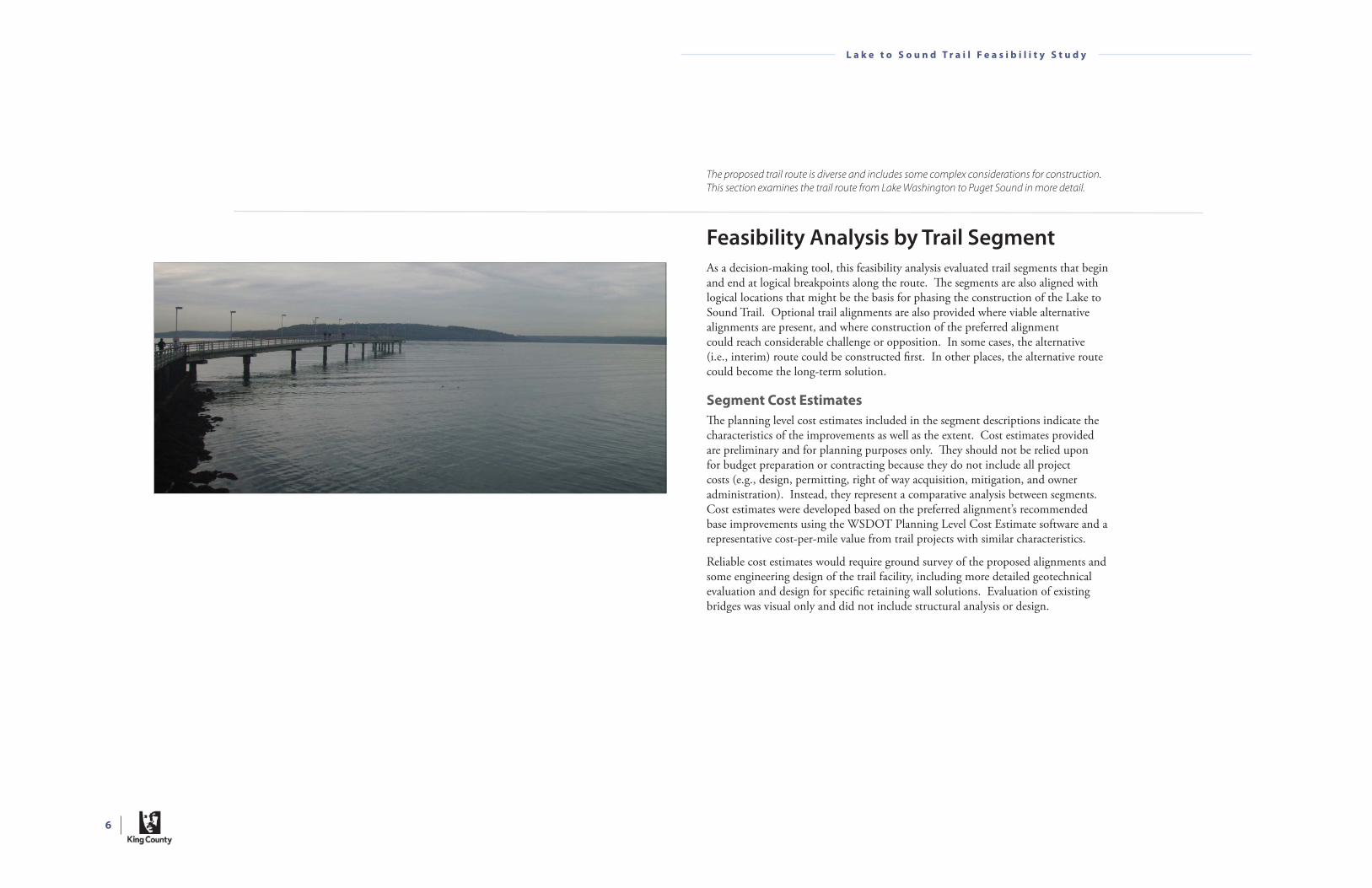
Feasibility Analysis by Trail Segment
As a decision-making tool, this feasibility analysis evaluated trail segments that begin and end at logical breakpoints along the route. Th e segments are also aligned with logical locations that might be the basis for phasing the construction of the Lake to Sound Trail. Optional trail alignments are also provided where viable alternative alignments are present, and where construction of the preferred alignment could reach considerable challenge or opposition. In some cases, the alternative (i.e., interim) route could be constructed fi rst. In other places, the alternative route could become the long-term solution.
Segment Cost Estimates
Th e planning level cost estimates included in the segment descriptions indicate the characteristics of the improvements as well as the extent. Cost estimates provided are preliminary and for planning purposes only. Th ey should not be relied upon for budget preparation or contracting because they do not include all project costs (e.g., design, permitting, right of way acquisition, mitigation, and owner administration). Instead, they represent a comparative analysis between segments. Cost estimates were developed based on the preferred alignment’s recommended base improvements using the WSDOT Planning Level Cost Estimate software and a representative cost-per-mile value from trail projects with similar characteristics.
Reliable cost estimates would require ground survey of the proposed alignments and some engineering design of the trail facility, including more detailed geotechnical evaluation and design for specifi c retaining wall solutions. Evaluation of existing bridges was visual only and did not include structural analysis or design.
The proposed trail route is diverse and includes some complex considerations for construction.
This section examines the trail route from Lake Washington to Puget Sound in more detail.
7
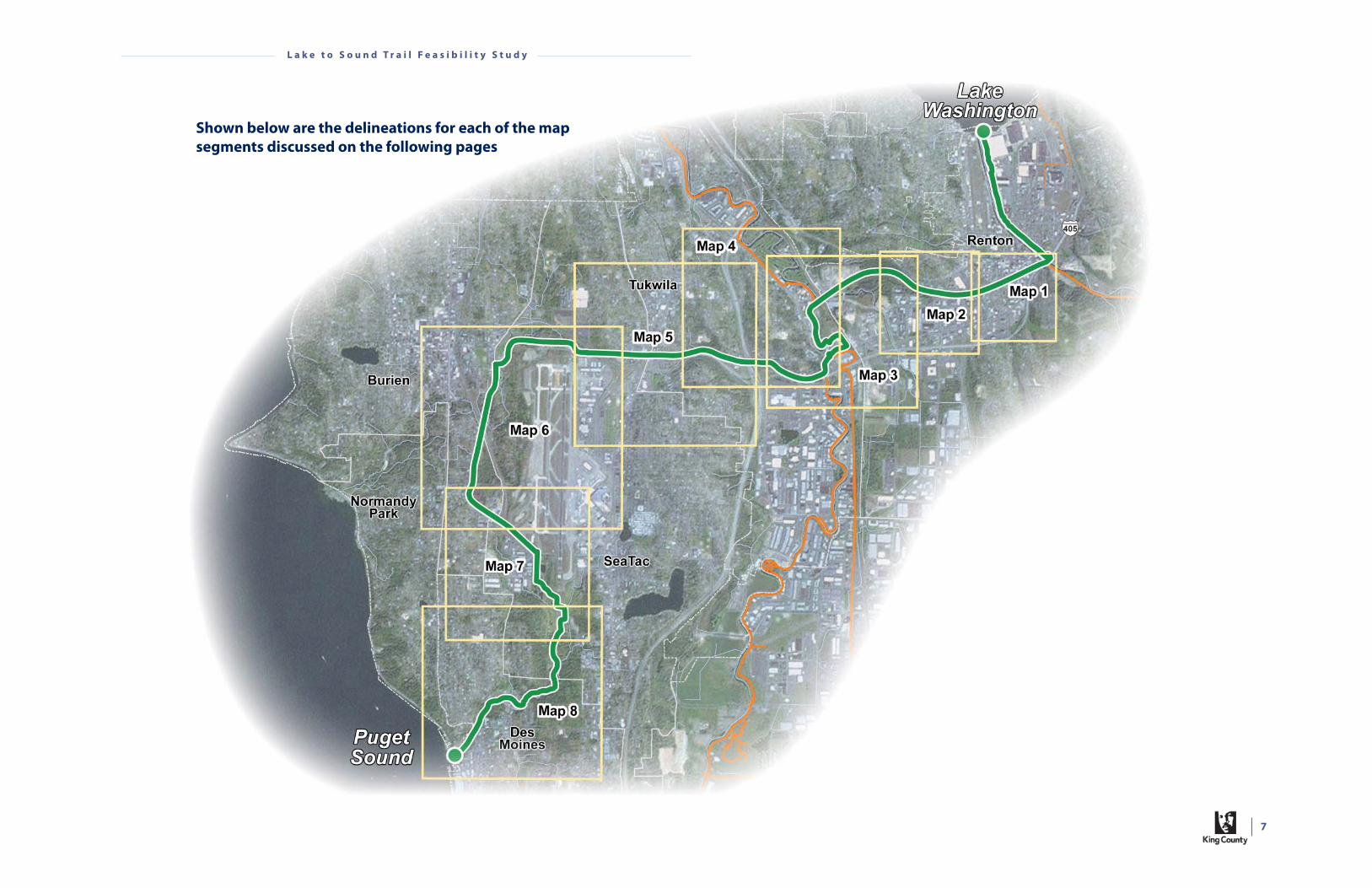
L a k e t o S o u n d T r a i l F e a s i b i l i t y S t u d y
Shown below are the delineations for each of the map
segments discussed on the following pages

8
L a k e t o S o u n d T r a i l F e a s i b i l i t y S t u d y
Map 1
Th is segment of the trail makes the necessary connection to the Cedar River Trail, allowing for access to Lake Washington to the north and the foothills to the southeast. It takes trail users through the heart of downtown Renton, through or near numerous parks (i.e., Cedar River Park, Liberty Skate Park, Veterans Memorial Park, Tomkin Park, and Burnett Linear Park); the Renton Public Library; the Regional Transit Center; numerous historic sites (e.g., Alki Saloon, First Presbyterian Church); the Renton History Museum; the South Renton Park and Ride; and many restaurants and shops.
Preferred Alignment
Th e eastern terminus of the proposed Lake to Sound Trail begins at the Cedar River Trail crossing beneath I-405 near Cedar River Park. Th e Cedar River Trail connects north to residential areas, Lake Washington, and Gene Coulon Park. West from Cedar River Park, the proposed Lake to Sound Trail would be a sidepath adjacent to Houser Way N under I-405, between S 3rd Street and the Burlington Northern Santa Fe (BNSF) railroad tracks. Th is segment of the trail would require a right of way agreement with WSDOT and potentially BNSF.
After crossing S 3rd Street, the trail would continue as a shared-use roadway on the access road adjacent to Houser Way S between Mill Avenue S and Main Avenue S. Th is access road is separated from Houser Way S by a raised curb. Vehicles enter this one-way side road off of Main Avenue S to access a driveway to a parking lot for a few local businesses or S 3rd Street. Access to the parking lot for these businesses is also granted on Main Avenue S and S 3rd Street. Th us, traffi c volumes are expected to be relatively low.
After crossing Main Avenue S, the trail would revert to a sidepath on the south side of Houser Way S west through Burnett Avenue S. Th is confi guration would require parking removal on the south side of the road. Th e vehicular traffi c lane would continue to coincide with the location of the railroad tracks, and parking on the north side of the road would be preserved. Th e advantage of using the road right of way through downtown Renton to construct a sidepath by extending the south sidewalk (versus an in-road facility) is the separation from vehicular traffi c. Th e sidewalk along the north side of Houser Way S would remain.
Houser Way S looking southwest into downtown Renton would provide a shared-use roadway.
Planning-Level Cost Estimate:
Preferred Alignment: $0.8 to $1.1 million
Alternative Alignment: $0.6 to $0.7 million
This map and the associated discussion and cost estimates encompass the area in the city of Renton from Lake Washington and the Cedar River Trail near its intersection with I-405 west to Shattuck Avenue S.
PreferredNewOptionalNewPreferredExistingOptionalExistingExistingTrail
9
L a k e t o S o u n d T r a i l F e a s i b i l i t y S t u d y
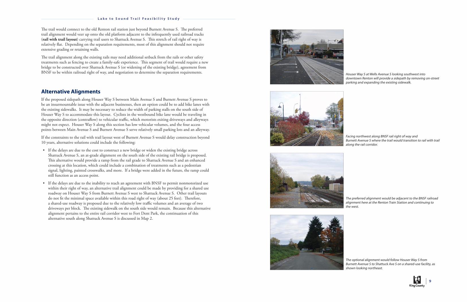
Houser Way S at Wells Avenue S looking southwest into downtown Renton will provide a sidepath by removing on-street parking and expanding the existing sidewalk.
Th e trail would connect to the old Renton rail station just beyond Burnett Avenue S. Th e preferred trail alignment would veer up onto the old platform adjacent to the infrequently used railroad tracks (rail with trail layout) carrying trail users to Shattuck Avenue S. Th is stretch of rail right of way is relatively fl at. Depending on the separation requirements, most of this alignment should not require extensive grading or retaining walls.
Th e trail alignment along the existing rails may need additional setback from the rails or other safety treatments such as fencing to create a family-safe experience. Th is segment of trail would require a new bridge to be constructed over Shattuck Avenue S (or widening of the existing bridge), agreement from BNSF to be within railroad right of way, and negotiation to determine the separation requirements.
Alternative Alignments
If the proposed sidepath along Houser Way S between Main Avenue S and Burnett Avenue S proves to be an insurmountable issue with the adjacent businesses, then an option could be to add bike lanes with the existing sidewalks. It may be necessary to reduce the width of parking stalls on the south side of Houser Way S to accommodate this layout. Cyclists in the westbound bike lane would be traveling in the opposite direction (contrafl ow) to vehicular traffi c, which motorists exiting driveways and alleyways might not expect. Houser Way S along this section has low vehicular volumes, and the four access points between Main Avenue S and Burnett Avenue S serve relatively small parking lots and an alleyway.
If the constraints to the rail with trail layout west of Burnett Avenue S would delay construction beyond 10 years, alternative solutions could include the following:
• If the delays are due to the cost to construct a new bridge or widen the existing bridge across Shattuck Avenue S, an at-grade alignment on the south side of the existing rail bridge is proposed. Th is alternative would provide a ramp from the rail grade to Shattuck Avenue S and an enhanced crossing at this location, which could include a combination of treatments such as a pedestrian signal, lighting, painted crosswalks, and more. If a bridge were added in the future, the ramp could still function as an access point.
• If the delays are due to the inability to reach an agreement with BNSF to permit nonmotorized use within their right of way, an alternative trail alignment could be made by providing for a shared use roadway on Houser Way S from Burnett Avenue S west to Shattuck Avenue S. Other trail layouts do not fi t the minimal space available within this road right of way (about 25 feet). Th erefore, a shared-use roadway is proposed due to the relatively low traffi c volumes and an average of two driveways per block. Th e existing sidewalk on the south side would remain. Because this alternative alignment pertains to the entire rail corridor west to Fort Dent Park, the continuation of this alternative south along Shattuck Avenue S is discussed in Map 2.
Facing northwest along BNSF rail right of way and Burnett Avenue S where the trail would transition to rail with trail along the rail corridor.
The preferred alignment would be adjacent to the BNSF railroad alignment here at the Renton Train Station and continuing to the west.
The optional alignment would follow Houser Way S from Burnett Avenue S to Shattuck Ave S on a shared-use facility, as shown looking northeast.
10
L a k e t o S o u n d T r a i l F e a s i b i l i t y S t u d y
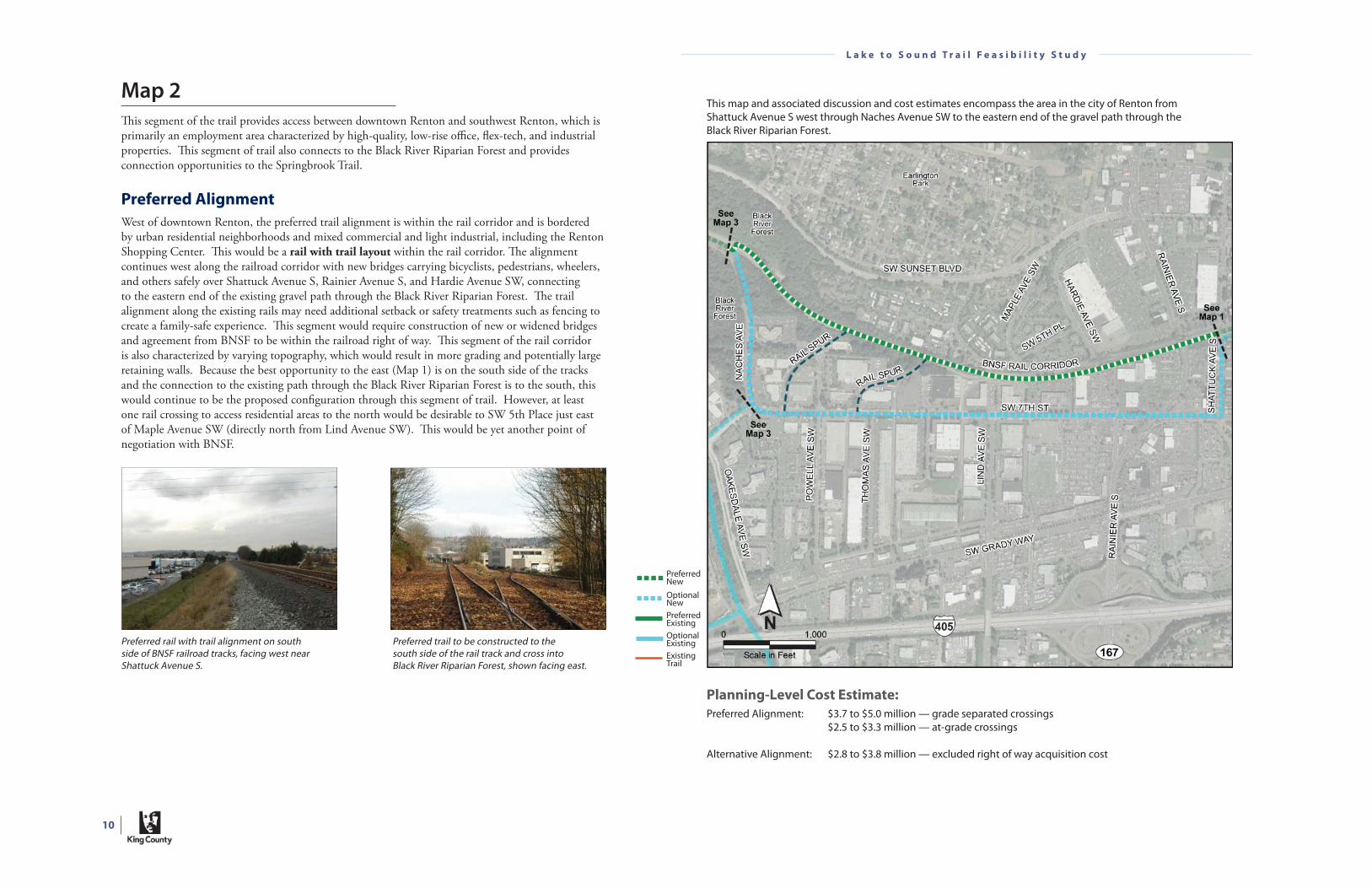
Map 2
Th is segment of the trail provides access between downtown Renton and southwest Renton, which is primarily an employment area characterized by high-quality, low-rise offi ce, fl ex-tech, and industrial properties. Th is segment of trail also connects to the Black River Riparian Forest and provides connection opportunities to the Springbrook Trail.
Preferred Alignment
West of downtown Renton, the preferred trail alignment is within the rail corridor and is bordered by urban residential neighborhoods and mixed commercial and light industrial, including the Renton Shopping Center. Th is would be a rail with trail layout within the rail corridor. Th e alignment continues west along the railroad corridor with new bridges carrying bicyclists, pedestrians, wheelers, and others safely over Shattuck Avenue S, Rainier Avenue S, and Hardie Avenue SW, connecting to the eastern end of the existing gravel path through the Black River Riparian Forest. Th e trail alignment along the existing rails may need additional setback or safety treatments such as fencing to create a family-safe experience. Th is segment would require construction of new or widened bridges and agreement from BNSF to be within the railroad right of way. Th is segment of the rail corridor is also characterized by varying topography, which would result in more grading and potentially large retaining walls. Because the best opportunity to the east (Map 1) is on the south side of the tracks and the connection to the existing path through the Black River Riparian Forest is to the south, this would continue to be the proposed confi guration through this segment of trail. However, at least one rail crossing to access residential areas to the north would be desirable to SW 5th Place just east of Maple Avenue SW (directly north from Lind Avenue SW). Th is would be yet another point of negotiation with BNSF.
Preferred rail with trail alignment on south side of BNSF railroad tracks, facing west near Shattuck Avenue S.
Preferred trail to be constructed to the south side of the rail track and cross into Black River Riparian Forest, shown facing east.
Planning-Level Cost Estimate:
Preferred Alignment: $3.7 to $5.0 million — grade separated crossings $2.5 to $3.3 million — at-grade crossings
Alternative Alignment: $2.8 to $3.8 million — excluded right of way acquisition cost
This map and associated discussion and cost estimates encompass the area in the city of Renton from Shattuck Avenue S west through Naches Avenue SW to the eastern end of the gravel path through the Black River Riparian Forest.
PreferredNewOptionalNewPreferredExistingOptionalExistingExistingTrail

11
L a k e t o S o u n d T r a i l F e a s i b i l i t y S t u d y
Alternative Alignments
If these requirements for a rail with trail layout would delay construction beyond 10 years, alternative solutions could include the following:
• If the delays are due to the cost of bridge improvements along the railroad route, alternative at-grade crossings of Rainier Avenue S and Hardie Avenue SW are proposed. Th e Rainier Avenue S crossing could occur at the existing signalized intersection with S 4th Place. Th e Hardie Avenue SW crossing could occur south of the existing rail bridge. Th ese at-grade crossings would provide enhanced crossings, which could include a combination of treatments such as a pedestrian signal, lighting, painted crosswalks, and more. If the bridges were added in the future, one or both of these improvements could still function as an access point to the trail.
• If the delays of using the railroad route are due to the inability to reach an agreement with BNSF or an increase in grading and retaining wall costs, an alternative on-street alignment could continue south along Shattuck Avenue S to SW 7th Street and then west to Naches Avenue SW, where it would turn north to the existing path in the Black River Riparian Forest. Th is alternative is described in more detail below.
On Shattuck Avenue S, from Houser Way S to SW 7th Street, the proposed facility would be bike lanes and sidewalks on both sides of the street. Th e right of way width for this stretch of road is 60 feet, easily accommodating the proposed confi guration. Th e advantage of this type of facility is that improvements are symmetrical to the center of the right of way, avoiding impacts to residential properties on either side. Eastbound trail users from SW 7th Street would access the bike lanes and sidewalks on the east side of Shattuck Avenue S by crossing Shattuck Avenue S, which is stop-sign controlled. Additional treatments to increase the visibility of this crossing area could be installed.
Traffi c volumes on SW 7th Street are relatively high (17,000 average daily trips) between Shattuck Avenue S and Lind Avenue SW, which includes the Rainier Avenue S intersection. Th is high traffi c volume area and the free right turns at the intersection of Rainier Avenue S reduce the comfortableness of bike lanes to younger or less experienced riders, making the preferred facility layout a sidepath on the north side of SW 7th Street. Th e tradeoff s for developing a sidepath could be potential impacts to street trees and private properties, as well as a need to relocate utilities. Th ese potential impacts are described in greater detail by shorter segment below.
Th e 60-foot right of way width for SW 7th Street between Shattuck Avenue S and Hardie Avenue SW requires additional consideration. To minimize private property impacts, the setback between the existing curb and sidewalk could be eliminated, along with the street trees occurring in this setback. In the absence of separation, a barrier would be recommended to improve safety. However, the footprint of the sidepath would still extend north beyond the existing sidewalk, requiring an easement or partial property acquisition from the private properties to the north and likely mitigation for the loss of street trees. One residence and one commercial building may be close enough that code requirements for setbacks may not be met. Otherwise, property impacts would be mostly to landscaping and parking.
Optional alignment would include bike lanes and sidewalks along this segment of Shattuck Avenue S from SW 7th Street to Houser Way S, shown facing north.
From Hardie Avenue SW to Lind Avenue SW along SW 7th Street, traffi c volumes continue to be high, but the right of way width expands to 80 feet. While private property may still be aff ected, depending on fi nal design, the impacts could be smaller than those occurring to the east. Property impacts would likely be limited to landscaping and parking.
On SW 7th Street just west of Lind Avenue SW to Naches Avenue SW, traffi c volumes reduce signifi cantly. Th is provides some choices as to how the optional facility could be constructed. Th e recommended facility type continues to be a sidepath on the north side of SW 7th Street. Several design options could be considered to minimize private property impacts along this segment as described below:
• With the 80-foot right of way width, a sidepath immediately adjacent to the existing curb could potentially fi t without private property impacts. However, as described for the segment from Shattuck Avenue S to Hardie Avenue SW, street trees would be aff ected and a barrier would be required between the trail and the road.
• A previous analysis of SW 7th Street highlighted an opportunity to reduce the existing roadway layout of four lanes to three lanes (one lane in each direction and a center turn lane). Th is narrowing of one lane (about 12 feet wide) of SW 7th Street provides an opportunity to reconfi gure the roadway to accommodate the proposed sidepath where the north side curb lane existed. Th is narrowing could reduce the need to aff ect street trees and reduce property impacts along the north side to about 600 feet west of Lind Avenue SW, where tapering of the roadway is required to accommodate the lane reduction.
At Naches Avenue SW, the trail would turn north on a sidepath to the existing Black River Riparian Forest path. To accommodate the sidepath, parking restrictions along the east side of Naches Avenue SW might be required.
A sidepath could be constructed along the east side (left in photo) of Naches Avenue SW for trail users to access the Black River Riparian Forest.
A sidepath could be constructed along the north side (left in photo) of SW 7th Street to connect between Shattuck Avenue S and Naches Avenue S.
Heading north along Naches Avenue S, the optional trail alignment enters the Black River Riparian Forest and improves the existing pathway (center of photo).
The preferred alignment connects into the Black River Riparian Forest from the BNSF right of way from the east (right in photo).

12
L a k e t o S o u n d T r a i l F e a s i b i l i t y S t u d y
Map 3
Th is segment of the trail provides the connection between the cities of Renton and Tukwila, including a connection to the Green River Trail, which encompasses more than 19 miles from south Kent to south Seattle.
Preferred Alignment
Th e preferred trail alignment uses the existing trail through the northern section of the Black River Riparian Forest, improving it to the preferred section for a two-way multi-use trail. Th is area is a 93-acre wildlife refuge off ering trail users wonderful separation from the urban landscape, including roads and rail lines, while still making the important connections among employment, retail, and residential areas. Th e forest is also owned by the City of Renton and would not require property or easement acquisitions. However, the Black River Riparian Forest is a treasured ecosystem that supports diverse wildlife with wetlands and other habitats. It is home to more than 50 species of birds, including one of the largest blue heron colonies in the region. Trail improvements must comply with the avoidance, minimization, and compensatory mitigation requirements stipulated in the City of Renton’s critical areas code. Some treatments would be necessary to discourage trail users from encroaching on adjacent critical areas and habitat. Some citizens and groups may be concerned about the additional noise and visual disturbance that a wider, paved trail would create with more diverse, wheeled, higher-speed uses. Plantings to further screen the trail may be requested.
Th e trail through the Black River Riparian Forest emerges at Monster Road SW, on the north side of the Black River. Th e following alternatives have been identifi ed for crossing the road and river:
• Cross Monster Road SW by going under the existing bridge over the Black River. Users would cross over the Black River using the existing 8-foot-wide sidewalk on the west side of Monster Road SW. Th is sidewalk could likely be expanded to a sidepath layout with a railing separating users and traffi c for added safety. Th e advantage of this alternative is that potential confl icts with vehicular traffi c on Monster Road SW are avoided. Th e disadvantages are the relative cost to construct the undercrossing versus constructing at-grade crossing improvements, and the potential for the trail under the bridge to fl ood.
• Cross Monster Road SW at grade. It may be necessary to improve the safety of this crossing, due to the volumes of truck and other vehicular traffi c that occur on Monster Road SW. At this location, Monster Road SW curves slightly, and there are some rises and drops in roadway elevation, which further support improving the visibility of the trail crossing. Improvements could include high-visibility fl ashers, trail crossing signage, in-road refl ectors or lights, painted crosswalks, and/or a pedestrian-actuated crossing. Once on the west side of Monster Road SW, trail users would cross the Black River as described above. Th e advantage of this alternative compared to the bridge undercrossing would be a signifi cantly lower cost. Th e disadvantage would be residual concerns about the potential for confl icts with the at-grade crossing.
Planning-Level Cost Estimate:
Preferred Alignment: $1.4 to $1.9 million* $1.7 to $2.3 million — with Monster Road SW bridge widening* * Excluding critical area mitigation
Alternative Alignment: $0.7 to $1.0 million — improves SW Grady Way sidepath $5.2 to $6.9 million — improves SW Grady Way sidepath and widens bridge $0.4 to $0.6 million — through Boeing Longacres Industrial Park trail $1.1 to $1.4 million — along SW 16th Street to Longacres Drive SW
This map and associated discussion and cost estimates encompass the area from approximately Naches Avenue SW in the city of Renton west to the Green River Trail or southwest to the Interurban Trail, both of which are located in the city of Tukwila.
PreferredNewOptionalNewPreferredExistingOptionalExistingExistingTrail

13
L a k e t o S o u n d T r a i l F e a s i b i l i t y S t u d y
Th e preferred connection between the cities of Renton and Tukwila is an informal path on the south bank of the Black River between Monster Road SW and Fort Dent Park, at the Green River Trail, under a major rail corridor used by the Sounder commuter rail and freight operations. It is the preferred connection between Renton and Tukwila because it accommodates a two-way multi-use trail located away from roadways, and it is a direct connection to the Green River Trail. Th e undercrossing of the rail lines has good horizontal and vertical clearance for accommodating nonmotorized uses. However, this connection traverses some private property and would require discussion with property owners, which include Union Pacifi c, BNSF, the City of Tukwila, and the City of Renton. Th e rail companies may have concerns about trail user safety (and liability), as well as the potential for vandalism to rail property. Th ese concerns could be addressed through design treatments, such as fencing to prevent trail users from trespassing, coverings over the trail as it passes under the railroad bridge to protect from possible falling objects, and others.
Alternative Alignments
Some constraints to the preferred alignment could include (1) the ecological sensitivity of the Black River Riparian Forest, and (2) the requirement for an agreement with both Union Pacifi c and BNSF to cross under their rail lines. If either of these constraints would delay construction beyond 10 years, alternative alignments could build on the alternative alignment along SW 7th Street and include (1) a more direct connection south along SW Grady Way, or (2) a longer route south to an existing railroad undercrossing along S Longacres Way that connects to the Interurban Trail. Both of these alternative alignments would connect south using the Springbrook Trail to the intersection of SW Grady Way and Oakesdale Avenue SW.
From SW 7th Street, the Lake to Sound Trail would continue as a sidepath on the north side of the block between Naches Road SW and Oakesdale Avenue SW. Th e trail would cross Oakesdale Avenue SW and access the Springbrook Trail from the wastewater treatment facility driveway; this short segment of about 150 feet would be a shared-use roadway due to the low traffi c volume of this driveway and potential high cost of bridge improvements. Th e Springbrook Trail is an existing two-way multi-use trail.
SW Grady Way Connection
SW Grady Way between Oakesdale Avenue SW and Interurban Avenue S provides an 8-foot-wide sidepath on the north side that could be expanded on the east and west approaches to the bridge. Th e bridge section along SW Grady Way provides a barrier separation between four travel lanes and the sidewalk, with little to no room for narrowing travel lanes to widen this sidepath section. Widening the sidewalk would require structural modifi cations to the existing bridge. Disadvantages of this connection is that SW Grady Way experiences high traffi c volumes regularly, which makes it noisy and it has reduced air quality from vehicle exhaust. A connection through Th e Fun Center property, avoiding the driveway access points, is preferred to connect into the existing trail and bridge over the Duwamish River.
S Longacres Way Connection
Th e Springbrook Trail connects south, crossing SW Grady Way at Oakesdale Avenue SW at grade, and passing under I-405. WSDOT approval would be required for any improvements to the existing I-405 trail undercrossing such as increasing the trail width. Th e trail would connect along SW 16th Street on existing bike lanes and sidewalk on the south side to the Boeing Longacres Industrial Park. From SW 16th Street, two options are available for connecting to the S Longacres Way undercrossing of the Sounder lines: (1) Cross the parking lot for the Boeing Longacres Industrial Park with a shared-use roadway to access the existing two-way multi-use trail that is part of the Boeing property’s trail system, or (2) If the alternative through the industrial park is not feasible, continue on bike lanes and sidewalks along SW 16th Street to Longacres Drive SW.
Both the SW Grady Way and S Longacres Way alternative options connect to the intersection of S Longacres Way and Longacres Drive SW. From this point, the trail connects east passing the Sounder commuter rail station and crossing under the railroad lines to the Interurban Trail. Piers supporting the rail bridges limit the width through this undercrossing, thereby restricting the space for improvements. A shared-use roadway is the only alternative without signifi cant improvements to the bridges; however, a sidewalk is already provided for pedestrians along the south side of S Longacres Way. Crossing S Longacres Way at Nelson Place, trail users would access the existing Interurban Trail (a two-way multi-use trail) and connect north into Fort Dent Park.
The existing trail (shown above) through the Black River Riparian Forest would be improved to a two-way multi-use trail.
People use this informal trail to connect between Renton and Tukwila, which provides a grade separated under-crossing of the railroad lines.
The preferred alignment would cross along the west side (right in photo) of Monster Road SW and continue west under the railroad lines used by the Sounder commuter train and freight lines into Fort Dent Park.
S Longacres Way (shown adjacent facing west) provides an alternative alignment connection to the Interurban Trail and north to Fort Dent Park.
Both alternative alignments would use the existing Springbrook Trail (shown facing north) to Grady Way SW.
14
L a k e t o S o u n d T r a i l F e a s i b i l i t y S t u d y
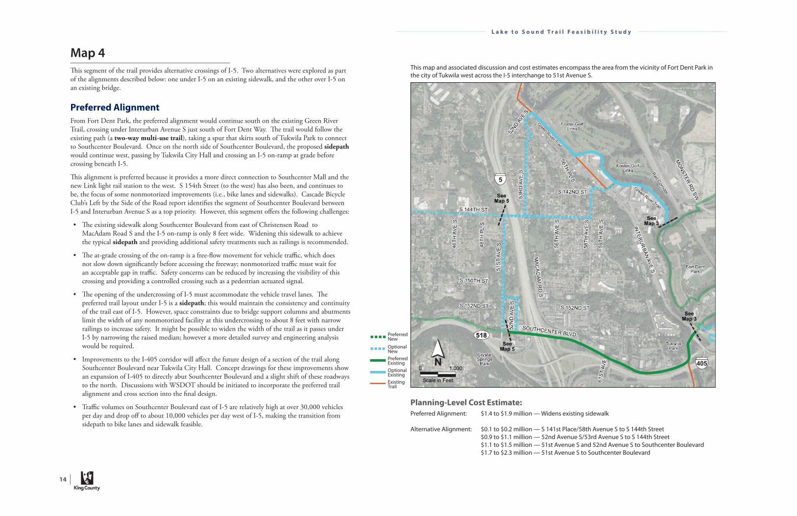
Map 4
Th is segment of the trail provides alternative crossings of I-5. Two alternatives were explored as part of the alignments described below: one under I-5 on an existing sidewalk, and the other over I-5 on an existing bridge.
Preferred Alignment
From Fort Dent Park, the preferred alignment would continue south on the existing Green River Trail, crossing under Interurban Avenue S just south of Fort Dent Way. Th e trail would follow the existing path (a two-way multi-use trail), taking a spur that skirts south of Tukwila Park to connect to Southcenter Boulevard. Once on the north side of Southcenter Boulevard, the proposed sidepath would continue west, passing by Tukwila City Hall and crossing an I-5 on-ramp at grade before crossing beneath I-5.
Th is alignment is preferred because it provides a more direct connection to Southcenter Mall and the new Link light rail station to the west. S 154th Street (to the west) has also been, and continues to be, the focus of some nonmotorized improvements (i.e., bike lanes and sidewalks). Cascade Bicycle Club’s Left by the Side of the Road report identifi es the segment of Southcenter Boulevard between I-5 and Interurban Avenue S as a top priority. However, this segment off ers the following challenges:
• Th e existing sidewalk along Southcenter Boulevard from east of Christensen Road to MacAdam Road S and the I-5 on-ramp is only 8 feet wide. Widening this sidewalk to achieve the typical sidepath and providing additional safety treatments such as railings is recommended.
• Th e at-grade crossing of the on-ramp is a free-fl ow movement for vehicle traffi c, which does not slow down signifi cantly before accessing the freeway; nonmotorized traffi c must wait for an acceptable gap in traffi c. Safety concerns can be reduced by increasing the visibility of this crossing and providing a controlled crossing such as a pedestrian actuated signal.
• Th e opening of the undercrossing of I-5 must accommodate the vehicle travel lanes. Th e preferred trail layout under I-5 is a sidepath; this would maintain the consistency and continuity of the trail east of I-5. However, space constraints due to bridge support columns and abutments limit the width of any nonmotorized facility at this undercrossing to about 8 feet with narrow railings to increase safety. It might be possible to widen the width of the trail as it passes under I-5 by narrowing the raised median; however a more detailed survey and engineering analysis would be required.
• Improvements to the I-405 corridor will aff ect the future design of a section of the trail along Southcenter Boulevard near Tukwila City Hall. Concept drawings for these improvements show an expansion of I-405 to directly abut Southcenter Boulevard and a slight shift of these roadways to the north. Discussions with WSDOT should be initiated to incorporate the preferred trail alignment and cross section into the fi nal design.
• Traffi c volumes on Southcenter Boulevard east of I-5 are relatively high at over 30,000 vehicles per day and drop off to about 10,000 vehicles per day west of I-5, making the transition from sidepath to bike lanes and sidewalk feasible.
Planning-Level Cost Estimate:
Preferred Alignment: $1.4 to $1.9 million — Widens existing sidewalk
Alternative Alignment: $0.1 to $0.2 million — S 141st Place/58th Avenue S to S 144th Street $0.9 to $1.1 million — 52nd Avenue S/53rd Avenue S to S 144th Street $1.1 to $1.5 million — 51st Avenue S and 52nd Avenue S to Southcenter Boulevard $1.7 to $2.3 million — 51st Avenue S to Southcenter Boulevard
This map and associated discussion and cost estimates encompass the area from the vicinity of Fort Dent Park in the city of Tukwila west across the I-5 interchange to 51st Avenue S.
PreferredNewOptionalNewPreferredExistingOptionalExistingExistingTrail
15
L a k e t o S o u n d T r a i l F e a s i b i l i t y S t u d y
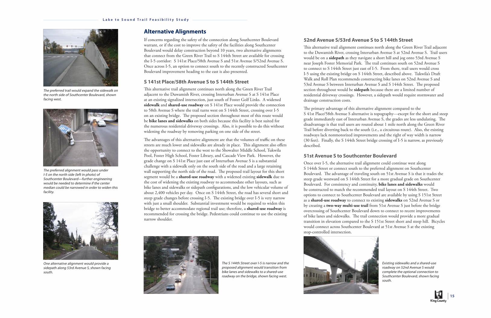
Alternative Alignments
If concerns regarding the safety of the connection along Southcenter Boulevard warrant, or if the cost to improve the safety of the facilities along Southcenter Boulevard would delay construction beyond 10 years, two alternative alignments that connect from the Green River Trail to S 144th Street are available for crossing the I-5 corridor: S 141st Place/58th Avenue S and 51st Avenue S/52nd Avenue S. Once across I-5, an option to connect south to the recently constructed Southcenter Boulevard improvement heading to the east is also presented.
S 141st Place/58th Avenue S to S 144th Street
Th is alternative trail alignment continues north along the Green River Trail adjacent to the Duwamish River, crossing Interurban Avenue S at S 141st Place at an existing signalized intersection, just south of Foster Golf Links. A widened sidewalk and shared-use roadway on S 141st Place would provide the connection to 58th Avenue S where the trail turns west on S 144th Street, crossing over I-5 on an existing bridge. Th e proposed section throughout most of this route would be bike lanes and sidewalks on both sides because this facility is best suited for the numerous residential driveway crossings. Also, it is possible to do this without widening the roadway by removing parking on one side of the street.
Th e advantages of this alternative alignment are that the volumes of traffi c on these streets are much lower and sidewalks are already in place. Th is alignment also off ers the opportunity to connect to the west to the Showalter Middle School, Tukwila Pool, Foster High School, Foster Library, and Cascade View Park. However, the grade change on S 141st Place just east of Interurban Avenue S is a substantial challenge with a sidewalk only on the south side of the road and a large retaining wall supporting the north side of the road. Th e proposed trail layout for this short segment would be a shared-use roadway with a widened existing sidewalk due to the cost of widening the existing roadway to accommodate other layouts, such as bike lanes and sidewalks or sidepath confi gurations, and the low vehicular volume of about 2,400 vehicles per day. Once on S 144th Street, the road has several short and steep grade changes before crossing I-5. Th e existing bridge over I-5 is very narrow with just a small shoulder. Substantial investment would be required to widen this bridge to better accommodate regional trail use; therefore, a shared-use roadway is recommended for crossing the bridge. Pedestrians could continue to use the existing narrow shoulder.
52nd Avenue S/53rd Avenue S to S 144th Street
Th is alternative trail alignment continues north along the Green River Trail adjacent to the Duwamish River, crossing Interurban Avenue S at 52nd Avenue S. Trail users would be on a sidepath as they navigate a short hill and jog onto 53rd Avenue S near Joseph Foster Memorial Park. Th e trail continues south on 52nd Avenue S to connect to S 144th Street just east of I-5. From there, trail users would cross I-5 using the existing bridge on S 144th Street, described above. Tukwila’s Draft Walk and Roll Plan recommends constructing bike lanes on 52nd Avenue S and 53rd Avenue S between Interurban Avenue S and S 144th Street. Th e proposed section throughout would be sidepath because there are a limited number of residential driveway crossings. However, a sidepath would require stormwater and drainage construction costs.
Th e primary advantage of this alternative alignment compared to the S 41st Place/58th Avenue S alternative is topography—except for the short and steep grade immediately east of Interurban Avenue S, the grades are less undulating. Th e disadvantage is that trail users are routed about 1 mile north along the Green River Trail before diverting back to the south (i.e., a circuitous route). Also, the existing roadways lack nonmotorized improvements and the right of way width is narrow (30 feet). Finally, the S 144th Street bridge crossing of I-5 is narrow, as previously described.
51st Avenue S to Southcenter Boulevard
Once over I-5, the alternative trail alignment could continue west along S 144th Street or connect south to the preferred alignment on Southcenter Boulevard. Th e advantage of traveling south on 51st Avenue S is that it trades the steep grade westward on S 144th Street for a more gradual grade on Southcenter Boulevard. For consistency and continuity, bike lanes and sidewalks would be constructed to match the recommended trail layout on S 144th Street. Two options to connect to Southcenter Boulevard are available by using S 151st Street as a shared-use roadway to connect to existing sidewalks on 52nd Avenue S or by creating a two-way multi-use trail from 51st Avenue S just before the bridge overcrossing of Southcenter Boulevard down to connect to recent improvements of bike lanes and sidewalks. Th e trail connection would provide a more gradual transition in elevation compared to the S 151st Street short and steep hill. Bicycles would connect across Southcenter Boulevard at 51st Avenue S at the existing stop-controlled intersection.
The preferred alignment would pass under I-5 on the north side (left in photo) of Southcenter Boulevard—further engineering would be needed to determine if the center median could be narrowed in order to widen this facility.
The preferred trail would expand the sidewalk on the north side of Southcenter Boulevard, shown facing west.
One alternative alignment would provide a sidepath along 53rd Avenue S, shown facing south.
The S 144th Street over I-5 is narrow and the proposed alignment would transition from bike lanes and sidewalks to a shared-use roadway on the bridge, shown facing west.
Existing sidewalks and a shared-use roadway on 52nd Avenue S would complete the optional connection to Southcenter Boulevard, shown facing south.

16
L a k e t o S o u n d T r a i l F e a s i b i l i t y S t u d y
Map 5
Th is segment of the trail provides a direct connection to the new Link light rail station to the west, through the cities of Tukwila and SeaTac, connecting to the existing Westside Trail.
Preferred Alignment
Th e preferred alignment crosses beneath I-5 along Southcenter Boulevard, which becomes S 154th Street. Th e alternative alignment crosses I-5 on the existing S 144th Street bridge. At 51st Avenue S, the alternative trail alignment could continue west along S 144th Street or else rejoin the preferred alignment along Southcenter Boulevard by traveling south on 51st Avenue S as described in Map 4.
From 51st Avenue S west, the preferred alignment along Southcenter Boulevard/S 154th Street would take advantage of the investments (bike lanes and a sidewalk on the north side) already being made by Sound Transit to improve the street and nonmotorized facilities. Eastbound bicyclists would cross at 51st Avenue S to connect to the sidepath crossing under I-5 for the preferred alignment. Th e preferred alignment would connect to the existing Westside Trail on the north side of Sea-Tac International Airport, west of 24th Avenue S.
Th is alignment is preferred because it makes a direct connection to the Westside Trail and to the new Link light rail station at Tukwila International Boulevard, a major regional destination. Southcenter Boulevard/S 154th Street is already the focus of nonmotorized improvements by Sound Transit (51st Avenue S to 42nd Avenue S) and the City of SeaTac (42nd Avenue S to 32nd Avenue S). However, some of these Sound Transit improvements on Southcenter Boulevard/S 154th Street may not attract the family-oriented use characteristic of a regional trail because the bicycle lanes are occasionally as narrow as 3 feet and the traffi c volumes on the street are relatively high. Th e ability to improve (i.e., widen) the nonmotorized facilities is constrained by light rail columns, as well as existing retaining walls. Th e grade through this area is a concern for some users but provide a gentler grade than the alternative alignment.
The preferred alignment will use the recently installed bike lanes and sidewalks along Southcenter Boulevard, facing west.
Planning-Level Cost Estimate:
Preferred Alignment: $1.7 to $2.3 million — widens bridge over SR 518
Alternative Alignment: $2.4 to $3.2 million — no bridge widening
This map and associated discussion and cost estimates encompass the area from 51st Avenue S in the city of Tukwila to the connection with the existing Westside Trail in the city of SeaTac, west of 24th Avenue S.
PreferredNewOptionalNewPreferredExistingOptionalExistingExistingTrail

17
L a k e t o S o u n d T r a i l F e a s i b i l i t y S t u d y
Alternative Alignment
If safety concerns along Southcenter Boulevard west of I-5 warrant the construction of safety improvements that would extend the start of construction beyond 10 years, an alternative alignment could be to continue on S 144th Street from 51st Avenue S to 24th Avenue S and south back to the preferred alignment, which ties into the Westside Trail.
Th e alternative route would take trail users directly by the Showalter Middle School, Tukwila Pool, Foster High School, Foster Library, and Cascade View Park. Th e City of Tukwila’s 2008 Draft Walk and Roll Plan recommends S 144th Street from Military Road to 53rd Avenue S as the best east-west route from the city of SeaTac to the city of Tukwila as it connects to parks, schools, and a park-and-ride lot. In the segment of roadway from Tukwila International Boulevard to Military Road S, signed and striped bike lanes have recently been constructed, along with sidewalks and street lamps. Th us, the proposed improvements would be to continue bike lanes and sidewalks from 53rd Avenue S to Tukwila International Boulevard. From Military Road S to 24th Avenue S, to maintain consistency and continuity with the existing facility type, bike lanes and sidewalks are recommended. Traffi c volumes are relatively low along S 144th Street, with about 5,000 vehicles per day east of Tukwila International Boulevard and 7,000 per day west, dropping off to 3,200 west of Military Road S. Th is alternative would take advantage of the wider right of way width than what is found on Southcenter Boulevard. A disadvantage would be that it does not connect directly to the new Link light rail station. Trail users would most likely use Tukwila International Boulevard to access the station.
Sidewalks are provided on both sides of 24th Avenue S, and a bike lane is provided along the west side. Th e roadway narrows on the bridge over SR 518, with no sidewalks, and narrow shoulders. To maintain consistency and continuity, a combination of on-street parking removal with roadway widening (more widening if parking is retained) would create enough space for a bike lane on the east side of the street to complete bike lanes and sidewalks on both sides of 24th Avenue S. Th e 24th Avenue S bridge over SR 518 provides wide shoulders for a shared-use roadway. Th is bridge could either be widened or the shoulders narrowed with restriping to accommodate a sidepath.
24th Avenue S, shown adjacent facing south, will be widened to complete bike lanes on both sides.
The alternative alignment would complete a bike lanes and sidewalks layout along S 144th Street, shown facing west near Tukwila International Boulevard.
The alternative alignment makes use of recent investments of bike lanes and sidewalks on S 144th Street between Tukwila International Boulevard and Military Road S (shown facing west).
West of Military Road S along S 144th Street, shown above facing west, bike lanes and sidewalks are part of the alternative alignment.
The alternative alignment would narrow slightly on the 24th Avenue S bridge over SR 518 and connect to the preferred Southcenter Boulevard alignment.
18
L a k e t o S o u n d T r a i l F e a s i b i l i t y S t u d y
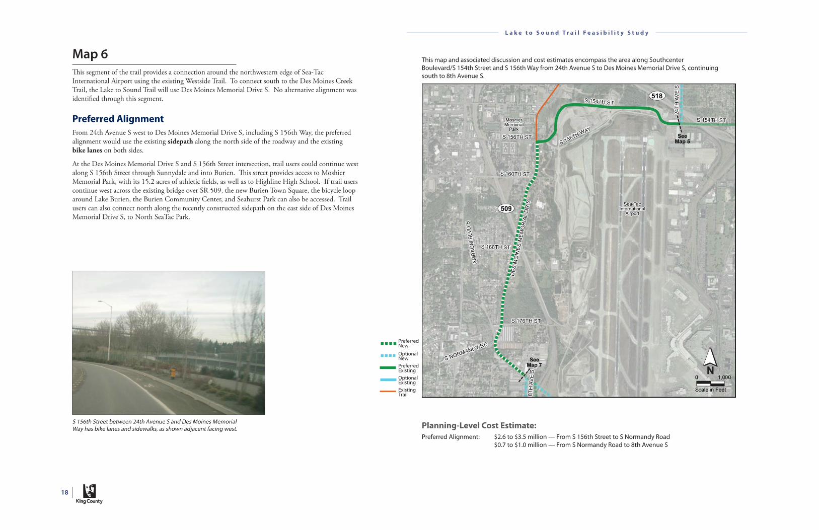
Map 6
Th is segment of the trail provides a connection around the northwestern edge of Sea-Tac International Airport using the existing Westside Trail. To connect south to the Des Moines Creek Trail, the Lake to Sound Trail will use Des Moines Memorial Drive S. No alternative alignment was identifi ed through this segment.
Preferred Alignment
From 24th Avenue S west to Des Moines Memorial Drive S, including S 156th Way, the preferred alignment would use the existing sidepath along the north side of the roadway and the existing bike lanes on both sides.
At the Des Moines Memorial Drive S and S 156th Street intersection, trail users could continue west along S 156th Street through Sunnydale and into Burien. Th is street provides access to Moshier Memorial Park, with its 15.2 acres of athletic fi elds, as well as to Highline High School. If trail users continue west across the existing bridge over SR 509, the new Burien Town Square, the bicycle loop around Lake Burien, the Burien Community Center, and Seahurst Park can also be accessed. Trail users can also connect north along the recently constructed sidepath on the east side of Des Moines Memorial Drive S, to North SeaTac Park.
Planning-Level Cost Estimate:
Preferred Alignment: $2.6 to $3.5 million — From S 156th Street to S Normandy Road $0.7 to $1.0 million — From S Normandy Road to 8th Avenue S
This map and associated discussion and cost estimates encompass the area along Southcenter Boulevard/S 154th Street and S 156th Way from 24th Avenue S to Des Moines Memorial Drive S, continuing south to 8th Avenue S.
S 156th Street between 24th Avenue S and Des Moines Memorial Way has bike lanes and sidewalks, as shown adjacent facing west.
PreferredNewOptionalNewPreferredExistingOptionalExistingExistingTrail
19
L a k e t o S o u n d T r a i l F e a s i b i l i t y S t u d y
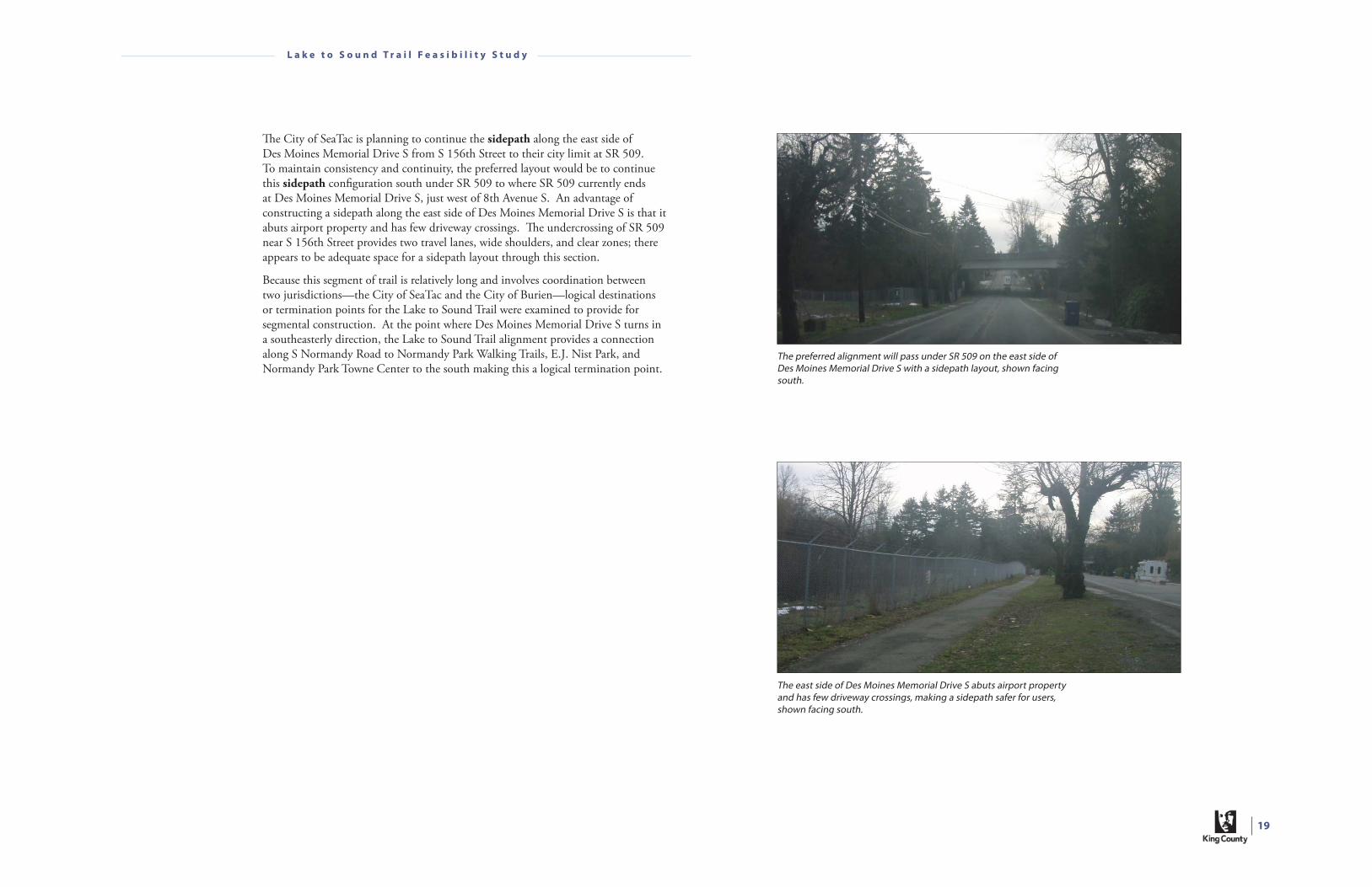
Th e City of SeaTac is planning to continue the sidepath along the east side of Des Moines Memorial Drive S from S 156th Street to their city limit at SR 509. To maintain consistency and continuity, the preferred layout would be to continue this sidepath confi guration south under SR 509 to where SR 509 currently ends at Des Moines Memorial Drive S, just west of 8th Avenue S. An advantage of constructing a sidepath along the east side of Des Moines Memorial Drive S is that it abuts airport property and has few driveway crossings. Th e undercrossing of SR 509 near S 156th Street provides two travel lanes, wide shoulders, and clear zones; there appears to be adequate space for a sidepath layout through this section.
Because this segment of trail is relatively long and involves coordination between two jurisdictions—the City of SeaTac and the City of Burien—logical destinations or termination points for the Lake to Sound Trail were examined to provide for segmental construction. At the point where Des Moines Memorial Drive S turns in a southeasterly direction, the Lake to Sound Trail alignment provides a connection along S Normandy Road to Normandy Park Walking Trails, E.J. Nist Park, and Normandy Park Towne Center to the south making this a logical termination point.
The preferred alignment will pass under SR 509 on the east side of Des Moines Memorial Drive S with a sidepath layout, shown facing south.
The east side of Des Moines Memorial Drive S abuts airport property and has few driveway crossings, making a sidepath safer for users, shown facing south.

20
L a k e t o S o u n d T r a i l F e a s i b i l i t y S t u d y
Map 7
Th is segment of the trail provides an opportunity to construct a separated trail in WSDOT right of way as part of the planned SR 509 extension project and to connect to the Des Moines Creek Trail.
Preferred Alignment
Th e preferred trail would be a two-way multi-use trail constructed alongside the proposed SR 509 extension roadway completing the western connection through the city of SeaTac and the city of Des Moines and around the Sea-Tac International Airport. Th is trail would connect to the existing Des Moines Creek Trail. Although WSDOT has begun design of the SR 509 extension project, which includes the two-way multi-use trail connecting from Des Moines Memorial Drive S to the Des Moines Creek Trail, funding is not currently available. It is anticipated that the trail would be constructed at the same time as the roadway, not before, to avoid throw-away construction costs and trail closure during construction.
Planning-Level Cost Estimate:
Preferred Alignment: $1.5 to $2.0 million*
Alternative Alignment: $1.5 to $1.9 million — S 188th Street to Des Moines Memorial Drive S $2.1 to $2.7 million — 8th Avenue S and S 192nd Street
*Extra cost items that may be required for matching elevations or grade separated crossings were not taken into consideration at this time and should be based on further consultation with the SR 509 extension project.
This map and associated discussion and cost estimates encompass the area from Des Moines Memorial Drive S near 8th Avenue S south to S 200th Street.
Shown above is Des Moines Memorial Drive S under-crossing of SR 509. SR 509 is proposed to be extended to the south and provide a two-way multi-use trail connection to S 200th Street.
The alternative sidepath under-crossing would likely be narrow requiring the roadway to be shifted slightly to widen the shoulder area on one side for a sidepath.
PreferredNewOptionalNewPreferredExistingOptionalExistingExistingTrail

21
L a k e t o S o u n d T r a i l F e a s i b i l i t y S t u d y
Alternative Alignments
If the construction timeframe of the SR 509 extension and accompanying trail would delay construction beyond 10 years or if state right of way is not available, two alternative alignments are proposed that (1) connect along Des Moines Memorial Drive S and S 196th Street to the existing Green River Trail just south of S 200th Street, or (2) connect south along 8th Avenue S to S 192nd Street, over to Des Moines Memorial Drive S and S 196th Street to S 200th Street, as presented in the 2004 Westside Trail Corridor Study. Both of these alternatives would connect along S 196th Street and 18th Avenue S to S 200th Street.
Des Moines Memorial Drive S
To maintain consistency and continuity, a sidepath layout would be maintained along the north side of Des Moines Memorial Drive S to the point where it turns south at S 188th Street and Starling Way. Th e trail would cross over an SR 509 stop-controlled off -ramp and free fl ow on-ramp. Th e roadway width under the SR 509 ramps along Des Moines Memorial Drive S is narrow, providing enough space for four travel lanes and narrow shoulders. In order to accommodate the trail through this section, the roadway may need to be shifted, reducing the shoulder on the south side of Des Moines Memorial Drive S to make room for a narrowed trail layout with barrier median on the north side.
Once the trail turns south along Des Moines Memorial Drive S at S 188th Street and Starling Way, the trail would use the existing sidewalks and narrow paved shoulders until they end, just north of S 194th Street. From north of S 194th Street to S 196th Street, where the trail would turn east, the roadway provides two travel lanes and a narrow shoulder on the west side of the roadway. Th is section would be widened to match the bike lanes and sidewalks to the north.
S 196th Street to S 200th Street is a narrow, two-lane roadway with a rural feel, a speed limit of 25 miles per hour, and no sidewalk or roadway markings. Th e preferred layout for this section is a shared-use roadway with traffi c calming treatments (i.e., chicanes, speed humps, and speed tables) because this roadway is proposed to be vacated with the construction of the SR 509 extension project, if not before.
8th Avenue S: Westside Trail Corridor Study
Th e alignment presented in the 2004 Westside Trail Corridor Study proposes bike lanes and sidewalks along 8th Avenue S, S 192nd Street, Des Moines Memorial Drive S, and S 196th Street to S 200th Street to connect to the Des Moines Creek Trail. Considerations for this alignment were connectivity to planned trails and lower volume roadways. Th is proposal was modifi ed slightly to match the preferred alignment improvements to S 196th Street of a shared-use roadway because this roadway is proposed to be vacated as mentioned above.
Th e planning-level cost range presented in the 2004 report for this alternative alignment is estimated to be about $1.7 million to $2.0 million, including improvements to S 200th Street from S 196th Street to the Des Moines Creek Trail parking lot (discussed in Map 8)—this cost has been updated for this report.
8th Avenue S would be improved to complete a bike lanes and sidewalks layout, shown facing south.
Widening S 192nd Street for bike lanes and sidewalks would completed the connection to Des Moines Memorial Drive, shown facing east.

22
L a k e t o S o u n d T r a i l F e a s i b i l i t y S t u d y
Map 8
Th e Des Moines Creek Trail provides an existing logical connection to Puget Sound and Des Moines Beach Park. Th is existing trail provides a two-way multi-use trail that winds its way through a wooded ravine to Puget Sound.
Preferred Alignment
Th e preferred trail alignment continues to be the nonmotorized facility proposed as part of the SR 509 extension project, which is a sidepath along the south side of S 200th Street between 18th Avenue S and the existing Des Moines Creek Trail and parking lot. Th is alignment and facility type is also recommended in the 2004 Westside Trail Corridor Study. Th is facility would connect around the west and south sides of the existing parking to tie into the existing Des Moines Creek Trail to avoid confl icts with vehicles maneuvering in the parking lot. From the Des Moines Creek Trail parking lot at S 200th Street, the Lake to Sound Trail would connect south along the existing two-way multi-use trail to the Sound at Des Moines Beach Park.
Planning-Level Cost Estimate:
Preferred Alignment: $0.3 to $0.5 million*
Alternative Alignment: Less than $0.1 million
*Extra cost items that may be required for matching elevations or grade separated crossings were not taken into consideration at this time and should be based on further consultation with the SR 509 extension project.
This map and associated discussion and cost estimates encompass the area along the Des Moines Creek Trail from S 200th Street to the Des Moines Beach Park.
The Des Moines Creek Trail at S 200th Street shown facing south.
PreferredNewOptionalNewPreferredExistingOptionalExistingExistingTrail

23
L a k e t o S o u n d T r a i l F e a s i b i l i t y S t u d y
Alternative Alignment
If the construction timeframe of the SR 509 extension and accompanying trail would delay construction beyond 10 years or if right of way is not available, an alternative alignment that connects from 18th Avenue S across S 200th Street to the vacated right of way and ties into Des Moines Creek Trail is suggested.
Access to 18th Avenue S south of S 200th Street has been restricted and is currently blocked by a fence. Connections through the fence are causal, but the hard surface path is usable by bicyclists and pedestrians. Although this roadway does not tie directly into the Des Moines Creek Trail, a short connection could be constructed by extending S 208th Street to the east. Th e advantage of this alignment, over the S 200th Street alignment, is that construction costs are minimized by delaying construction along S 200th Street until such as time as WSDOT constructs the sidepath as part of the SR 509 project.
The Puget Sound at Des Moines Beach Park, facing west.
The trail connects through the Des Moines Beach Park to the Puget Sound, shown facing west.
Until the sidepath along S 200th Street is constructed as part of the SR 509 extension project, or before, the abandoned portion of 18th Avenue S between S 200th Street and S 208th Street could be used, shown facing south.

24
L a k e t o S o u n d T r a i l F e a s i b i l i t y S t u d y
Next Steps
Steps are being taken to maintain the momentum of this great project. Two segments of the Lake to Sound Trail were recommended to the stakeholders as the parts of the trail that are most ready for preliminary design and environmental review. Th e stakeholders are proceeding forward with securing funding for both design and construction. Th e two segments that were submitted to the Puget Sound Regional Council in May 2009 for Congestion Mitigation and Air Quality (CMAQ) grant money were:
• Segment A: Th rough the Black River Riparian forest from Naches Avenue SW (City of Renton), crossing Monster Rd SW, to arrive at Fort Dent Park (City of Tukwila) — a 1.06 mile segment shown on Map 3 with a $2.53 million estimated project cost. Th is segment extends to Naches Avenue SW to provide a connection to existing facilities until future alignments are constructed east of this location.
• Segment B: Along Des Moines Memorial Drive from S 156th Street (City of SeaTac) to S Normandy Road (City of Burien) — a 1.45 mile segment shown on Map 6 with a $4.23 million estimated project cost. Th is segment stops at S Normandy Road to connect to existing facilities.
Project costs (presented here) are higher than Construction costs (presented in map segments) as project costs include such costs as project administration, environmental permitting, wetland mitigation, contingency, and an art budget.
Th e total project cost for delivering these two segments constructed was estimated to be $7.8 million based on planning-level cost estimates. Th is total project costs includes existing expenditures on the planning and development of this feasibility study. It also includes expenses for certifying agency administration, construction across multiple jurisdictions, engineering, and federal fund management.