Lake Chemistry and Physical Data For Selected North Slope ...
Lake Chemistry and Physical Data For Selected North Slope, Alaska, Lakes:
September 2007
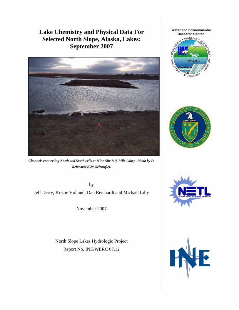
Channels connecting North and South cells at Mine Site B (6-Mile Lake), Photo by D.
Reichardt (GW-Scientific).
by
Jeff Derry, Kristie Holland, Dan Reichardt and Michael Lilly
November 2007
North Slope Lakes Hydrologic Project
Report No. INE/WERC 07.12

Lake Chemistry and Physical Data For Selected North Slope, Alaska, Lakes: September 2007
By:
Jeff Derry1, Kristie Holland1, Dan Reichardt1 and Michael Lilly1
A report on research sponsored by:
• U.S. Department of Energy
• National Energy Technology Laboratory
• BP Exploration (Alaska), Inc.
• ConocoPhillips Alaska, Inc.
• Bureau of Land Management
• Geo-Watersheds Scientific
November 2007
North Slope Lakes Hydrologic Project
Report Number INE/WERC 07.12
1Geo-Watersheds Scientific, Fairbanks, Alaska

Recommended Citation:
Derry, J., Holland, K.M., Reichardt, D.A., and Lilly, M.R., 2007. Lake Chemistry and Physical Data For Selected North Slope, Alaska, Lakes: September 2007. University of Alaska Fairbanks, Water and Environmental Research Center, Report INE/WERC 07.12, Fairbanks, Alaska, 11 pp.
Fairbanks, Alaska November 2007
For additional information write to: For Project Information write to: Publications, Daniel White – Project Manager Water and Environmental Research Center Box 5860, WERC. UAF University of Alaska Fairbanks Fairbanks, AK 99775-5860 Fairbanks, Alaska 99775 907-474-6222 www.uaf.edu/water/ [email protected]
i
TABLE OF CONTENTS TABLE OF CONTENTS................................................................................................................. i
LIST OF FIGURES ......................................................................................................................... i
LIST OF TABLES.......................................................................................................................... ii
DISCLAIMER ................................................................................................................................ ii
CONVERSION FACTORS, UNITS, WATER QUALITY UNITS, VERTICAL AND
HORIZONTAL DATUM, ABBREVIATIONS AND SYMBOLS ..................................... iii
PROJECT COOPERATORS........................................................................................................ vii
ACKNOWLEDGEMENTS.......................................................................................................... vii
INTRODUCTION .......................................................................................................................... 1
TRIP OBJECTIVES ....................................................................................................................... 2
PROCEDURES............................................................................................................................... 4
SELECTED RESULTS .................................................................................................................. 5
SUMMARY.................................................................................................................................. 10
REFERENCES ............................................................................................................................. 10
APPENDIX A. WATER QUALITY FIELD SAMPLING FORMS…………………….……A-1
APPENDIX B. WATER QUALITY METER CALIBRATION FORMS……………….……B-1
APPENDIX C. ELEVATION SURVEY FORMS………………………………………….…C-1
LIST OF FIGURES
Figure 1. Location of study lakes in the NPR-A, Alpine, Kuparuk, and Prudhoe Bay field
operating areas, North Slope, Alaska...................................................................................... 2
Figure 2. Newly relocated meteorological station at L9312. Photo by D. Reichardt. .................... 4
Figure 3. Mine Site B North and South Cell connecting channels cross-section profiles. ............. 6
Figure 4. Lake L9312 Outlet Channel Profiles Site Map ............................................................... 7
Figure 5 Lake L9312 outlet channel center-line profile. Point A-B is on the lake edge. ............... 8
Figure 6. Lake L9312 Outlet Control Cross Section Profile ......................................................... 9
LIST OF TABLES
Table 1. In-Situ Troll 9000 calibration quality control criteria. ..................................................... 5
Table 2. Lake L9312 Outlet Control Elevations, Method Comparison........................................ 10
DISCLAIMER The contents of this report reflect the views of the authors, who are responsible for the accuracy
of the data presented herein. This research was funded by the U.S. Department of Energy (DOE)
and the National Energy Technology Laboratory (NETL). Funding and support was also
provided by the Bureau of Land Management (BLM), BP Exploration (Alaska) Inc. (BPX),
ConocoPhillips Alaska, Inc. (CPA), and Geo-Watersheds Scientific (GWS). The contents of the
report do not necessarily reflect the views or policies of the DOE, NETL, BLM, BPX, CPA,
GWS, or any local sponsor. This work does not constitute a standard, specification, or regulation.
The use of trade and firm names in this document is for the purpose of identification only and
does not imply endorsement by the University of Alaska Fairbanks (UAF), DOE, NETL, BLM,
BPX, CPA, GWS, or other project sponsors.
ii
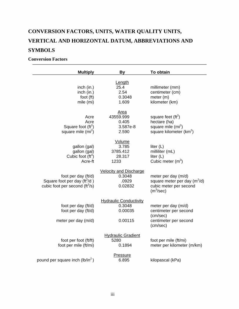
CONVERSION FACTORS, UNITS, WATER QUALITY UNITS,
VERTICAL AND HORIZONTAL DATUM, ABBREVIATIONS AND
SYMBOLS Conversion Factors
Multiply
By To obtain
Length
inch (in.) 25.4 millimeter (mm) inch (in.) 2.54 centimeter (cm)
foot (ft) 0.3048 meter (m) mile (mi) 1.609 kilometer (km)
Area
Acre 43559.999 square feet (ft2) Acre 0.405 hectare (ha)
Square foot (ft2) 3.587e-8 square mile (mi2) square mile (mi2) 2.590 square kilometer (km2)
Volume
gallon (gal) 3.785 liter (L) gallon (gal) 3785.412 milliliter (mL)
Cubic foot (ft3) 28.317 liter (L) Acre-ft 1233 Cubic meter (m3)
Velocity and Discharge
foot per day (ft/d) 0.3048 meter per day (m/d) Square foot per day (ft2/d ) .0929 square meter per day (m2/d)
cubic foot per second (ft3/s) 0.02832 cubic meter per second (m3/sec)
Hydraulic Conductivity
foot per day (ft/d) 0.3048 meter per day (m/d) foot per day (ft/d) 0.00035 centimeter per second
(cm/sec) meter per day (m/d) 0.00115 centimeter per second
(cm/sec)
Hydraulic Gradient foot per foot (ft/ft) 5280 foot per mile (ft/mi)
foot per mile (ft/mi) 0.1894 meter per kilometer (m/km)
Pressure pound per square inch (lb/in2 ) 6.895 kilopascal (kPa)
iii
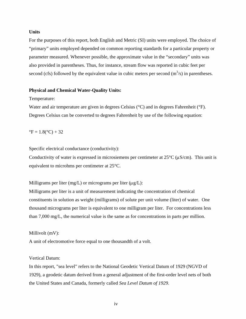
Units
For the purposes of this report, both English and Metric (SI) units were employed. The choice of
“primary” units employed depended on common reporting standards for a particular property or
parameter measured. Whenever possible, the approximate value in the “secondary” units was
also provided in parentheses. Thus, for instance, stream flow was reported in cubic feet per
second (cfs) followed by the equivalent value in cubic meters per second (m3/s) in parentheses.
Physical and Chemical Water-Quality Units:
Temperature:
Water and air temperature are given in degrees Celsius (°C) and in degrees Fahrenheit (°F).
Degrees Celsius can be converted to degrees Fahrenheit by use of the following equation:
°F = 1.8(°C) + 32
Specific electrical conductance (conductivity):
Conductivity of water is expressed in microsiemens per centimeter at 25°C (μS/cm). This unit is
equivalent to microhms per centimeter at 25°C.
Milligrams per liter (mg/L) or micrograms per liter (μg/L):
Milligrams per liter is a unit of measurement indicating the concentration of chemical
constituents in solution as weight (milligrams) of solute per unit volume (liter) of water. One
thousand micrograms per liter is equivalent to one milligram per liter. For concentrations less
than 7,000 mg/L, the numerical value is the same as for concentrations in parts per million.
Millivolt (mV):
A unit of electromotive force equal to one thousandth of a volt.
Vertical Datum:
In this report, "sea level" refers to the National Geodetic Vertical Datum of 1929 (NGVD of
1929), a geodetic datum derived from a general adjustment of the first-order level nets of both
the United States and Canada, formerly called Sea Level Datum of 1929.
iv

Horizontal Datum:
The horizontal datum for all locations in this report is the North American Datum of 1983 or
North American Datum of 1927.
v
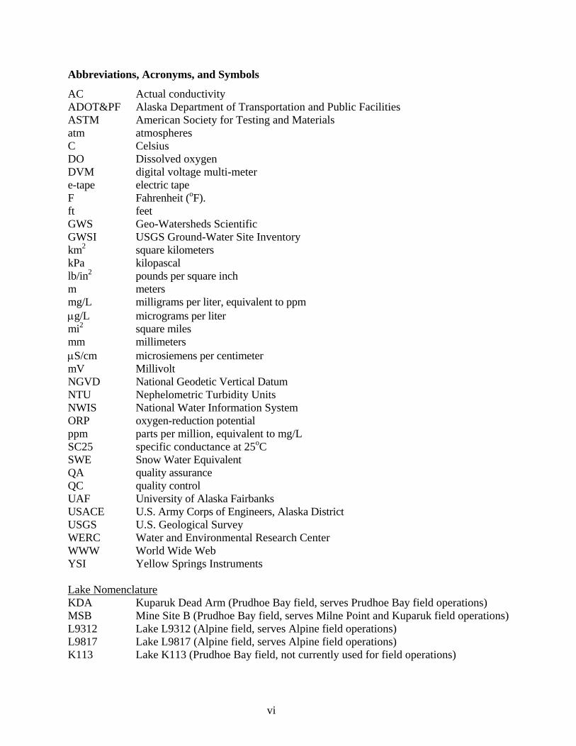
Abbreviations, Acronyms, and Symbols
AC Actual conductivity ADOT&PF Alaska Department of Transportation and Public Facilities ASTM American Society for Testing and Materials atm atmospheres C Celsius DO Dissolved oxygen DVM digital voltage multi-meter e-tape electric tape F Fahrenheit (oF). ft feet GWS Geo-Watersheds Scientific GWSI USGS Ground-Water Site Inventory km2 square kilometers kPa kilopascal lb/in2 pounds per square inch m meters mg/L milligrams per liter, equivalent to ppm μg/L micrograms per liter mi2 square miles mm millimeters μS/cm microsiemens per centimeter mV Millivolt NGVD National Geodetic Vertical Datum NTU Nephelometric Turbidity Units NWIS National Water Information System ORP oxygen-reduction potential ppm parts per million, equivalent to mg/L SC25 specific conductance at 25oC SWE Snow Water Equivalent QA quality assurance QC quality control UAF University of Alaska Fairbanks USACE U.S. Army Corps of Engineers, Alaska District USGS U.S. Geological Survey WERC Water and Environmental Research Center WWW World Wide Web YSI Yellow Springs Instruments Lake Nomenclature KDA Kuparuk Dead Arm (Prudhoe Bay field, serves Prudhoe Bay field operations) MSB Mine Site B (Prudhoe Bay field, serves Milne Point and Kuparuk field operations) L9312 Lake L9312 (Alpine field, serves Alpine field operations) L9817 Lake L9817 (Alpine field, serves Alpine field operations) K113 Lake K113 (Prudhoe Bay field, not currently used for field operations)
vi
PROJECT COOPERATORS The North Slope Lakes project covers a large area of the North Slope and benefits from a
number of positive partnerships, all contributing to the overall project objectives.
BP Exploration (Alaska) Inc.
ConocoPhillips Alaska, Inc. (CPA)
Bureau of Land Management
Alaska Department of Natural Resources
The Nature Conservancy
Northern Alaska Environmental Center
ACKNOWLEDGEMENTS This project was funded by cooperative agreement number DE-FC26_01NT41248, from the U.S.
Department of Energy’s (DOE) Arctic Energy Office to the University of Alaska Fairbanks
Arctic Energy Technology Development Laboratory (AETDL). Field coordination and logistics
support were provided by BP Exploration (Alaska) Inc. and ConocoPhillips Alaska. Additional
support was provided by other project cooperators, North Slope Borough, Bureau of Land
Management (BLM), National Weather Service, and Geo-Watersheds Scientific (GWS), in the
form of financial and in-kind match.
vii

1
Lake Chemistry and Physical Data For Selected North Slope,
Alaska, Lakes: September 2007
INTRODUCTION
The University of Alaska Fairbanks (UAF) Water and Environmental Research Center (WERC)
and Geo-Watersheds Scientific (GWS), together with project cooperators, initiated a study in the
Fall of 2002 (Phase One) to obtain baseline information about the physical and chemical
characteristics of North Slope tundra lakes. The project was extended in 2005 (Phase Two). The
location of the study lakes changed and was expanded to include reservoirs to help further
develop the understanding and simulation tools necessary for water-source management. K113 is
an un-pumped lake in the Kuparuk oilfield and is sampled on selected field trips during the year.
L9312 is a natural lake studied in the Alpine operations area. L9817 is a natural lake in eastern
NPRA, west of Nuiqsut. L9817 has been used in previous years for ice-road construction, but
was not used during winters of 2005-06 or 2006-07. Two reservoir systems (mine sites) were
added to the study in 2005. Mine Site B, also known as Six-Mile Lake, is located near the Milne
Point facility at the intersection of the Spine Road with the Milne Point access road and has two
cells connected to Milne Creek. The Kuparuk Reservoir System (Kuparuk Deadarm Lakes) has
eight reservoirs. The three southernmost reservoir cells (1-3) are included in the study to observe
ground-water and surface-water interactions between each cells and the adjacent Kuparuk River.
Water levels are occasionally measured in Cells 4 and 5. Figure 1 shows the location of study
lakes and reservoirs.
Water-quality and hydrologic data are collected in the field during monthly visits to the lakes and
water samples are collected from priority locations for further analysis at the UAF-WERC
chemistry laboratories. The purposes of this publication are to 1) report data collected for the
month of September 2007, 2) summarize accomplished field trip objectives.
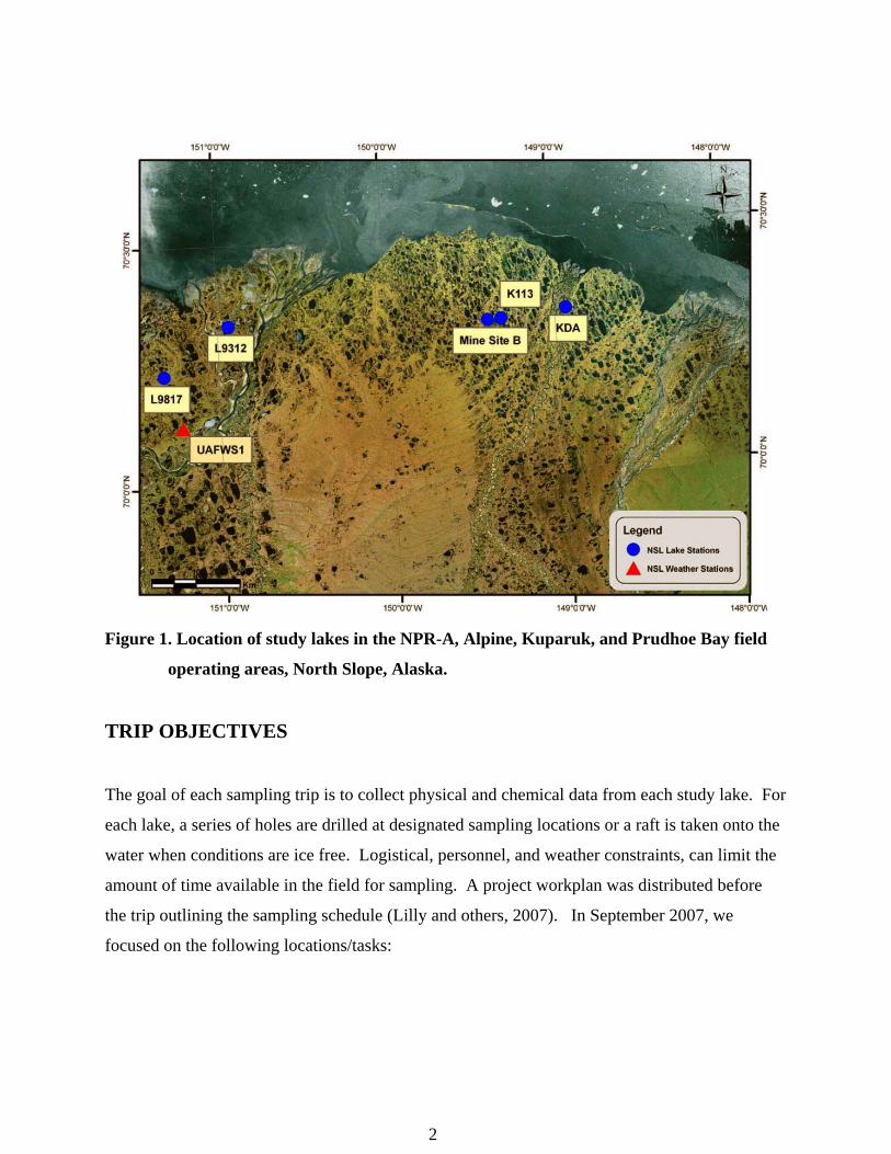
Figure 1. Location of study lakes in the NPR-A, Alpine, Kuparuk, and Prudhoe Bay field
operating areas, North Slope, Alaska.
TRIP OBJECTIVES
The goal of each sampling trip is to collect physical and chemical data from each study lake. For
each lake, a series of holes are drilled at designated sampling locations or a raft is taken onto the
water when conditions are ice free. Logistical, personnel, and weather constraints, can limit the
amount of time available in the field for sampling. A project workplan was distributed before
the trip outlining the sampling schedule (Lilly and others, 2007). In September 2007, we
focused on the following locations/tasks:
2
1. L9312, Alpine Facility
• Measure field water-quality parameters near Raft B location. This includes vertical
profile measurements for temperature, dissolved oxygen (DO), conductivity, pH,
turbidity, oxygen reduction potential (ORP) and barometric pressure.
• Survey water levels to local elevation control.
• Survey inlet and outlet channel water levels.
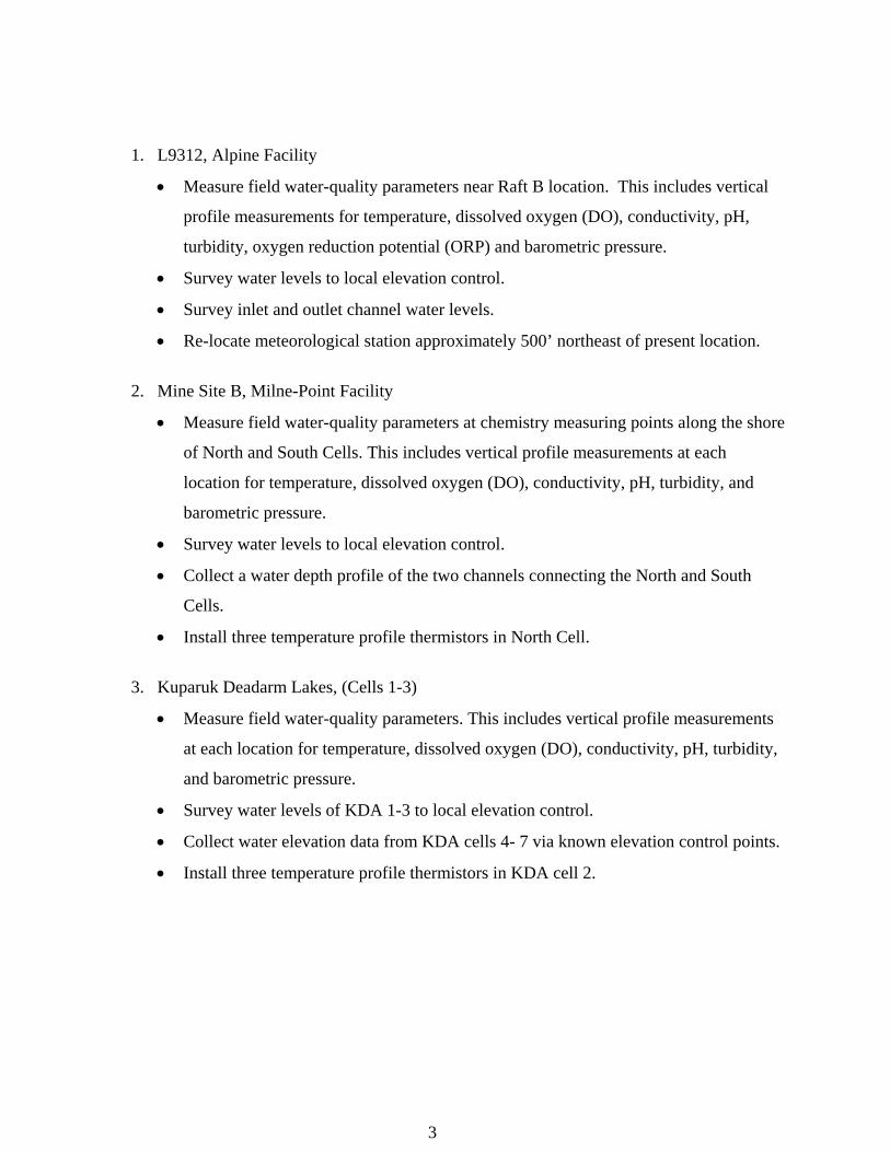
• Re-locate meteorological station approximately 500’ northeast of present location.
2. Mine Site B, Milne-Point Facility
• Measure field water-quality parameters at chemistry measuring points along the shore
of North and South Cells. This includes vertical profile measurements at each
location for temperature, dissolved oxygen (DO), conductivity, pH, turbidity, and
barometric pressure.
• Survey water levels to local elevation control.
• Collect a water depth profile of the two channels connecting the North and South
Cells.
• Install three temperature profile thermistors in North Cell.
3. Kuparuk Deadarm Lakes, (Cells 1-3)
• Measure field water-quality parameters. This includes vertical profile measurements
at each location for temperature, dissolved oxygen (DO), conductivity, pH, turbidity,
and barometric pressure.
• Survey water levels of KDA 1-3 to local elevation control.
• Collect water elevation data from KDA cells 4- 7 via known elevation control points.
• Install three temperature profile thermistors in KDA cell 2.
3
Figure 2. Newly relocated meteorological station at L9312. Photo by D. Reichardt.
PROCEDURES
Water Chemistry Sampling
All field work follows the specified health, safety, and environmental guidelines outlined by
BPX and CPA (White and Lilly, 2007 a, b, c). Physical measurements of water depth were
taken at each sampling location. Water quality parameters such as temperature, pH, turbidity,
oxygen reduction potential (ORP), conductivity, and dissolved oxygen (DO) were obtained by
using an In-Situ Troll 9000 (submersible meter), at multiple depths throughout the water column.
The precision with which physical measurements were reported takes into account field
conditions. The calibration of each parameter was checked before and after each day of
sampling using the criteria in Table 1.
4
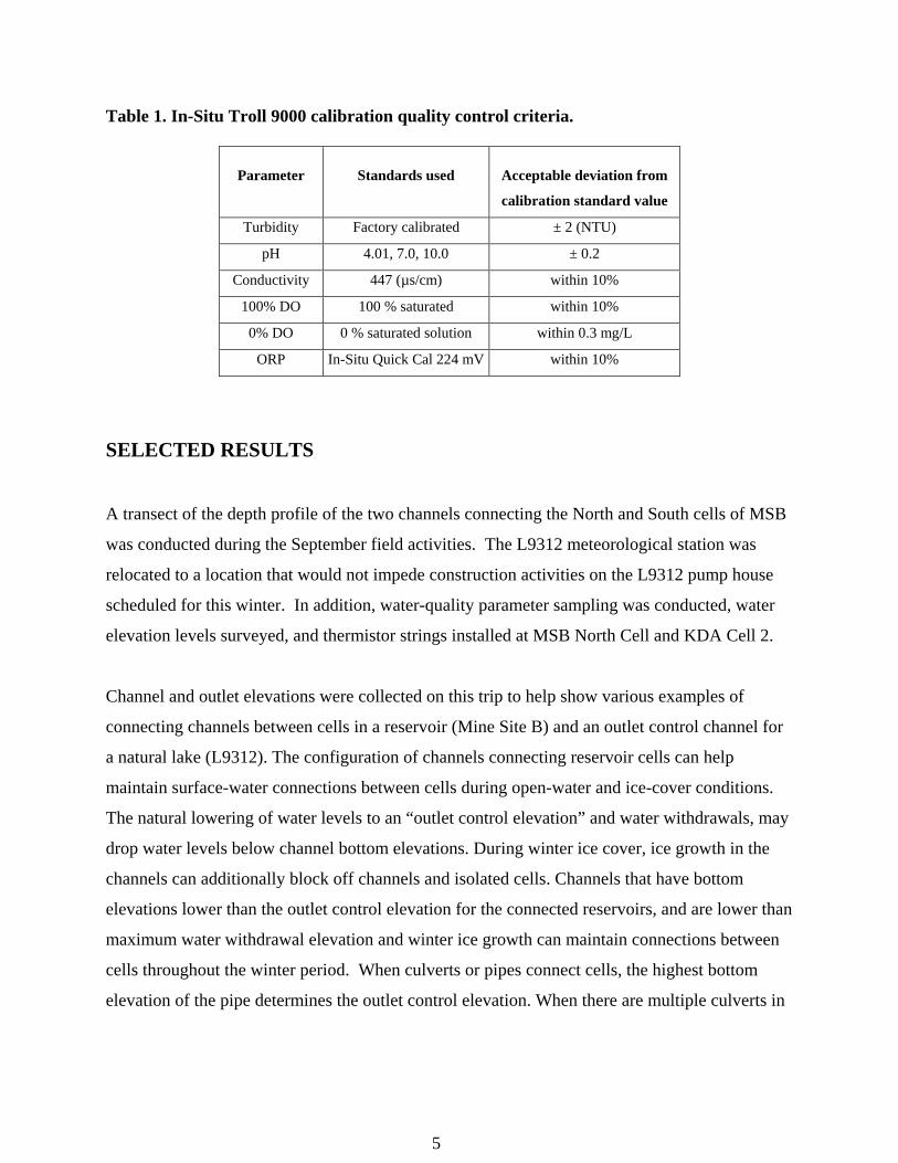
Table 1. In-Situ Troll 9000 calibration quality control criteria.
Parameter
Standards used
Acceptable deviation from
calibration standard value
Turbidity Factory calibrated ± 2 (NTU)
pH 4.01, 7.0, 10.0 ± 0.2
Conductivity 447 (µs/cm) within 10%
100% DO 100 % saturated within 10%
0% DO 0 % saturated solution within 0.3 mg/L
ORP In-Situ Quick Cal 224 mV within 10%
SELECTED RESULTS
A transect of the depth profile of the two channels connecting the North and South cells of MSB
was conducted during the September field activities. The L9312 meteorological station was
relocated to a location that would not impede construction activities on the L9312 pump house
scheduled for this winter. In addition, water-quality parameter sampling was conducted, water
elevation levels surveyed, and thermistor strings installed at MSB North Cell and KDA Cell 2.
Channel and outlet elevations were collected on this trip to help show various examples of
connecting channels between cells in a reservoir (Mine Site B) and an outlet control channel for
a natural lake (L9312). The configuration of channels connecting reservoir cells can help
maintain surface-water connections between cells during open-water and ice-cover conditions.
The natural lowering of water levels to an “outlet control elevation” and water withdrawals, may
drop water levels below channel bottom elevations. During winter ice cover, ice growth in the
channels can additionally block off channels and isolated cells. Channels that have bottom
elevations lower than the outlet control elevation for the connected reservoirs, and are lower than
maximum water withdrawal elevation and winter ice growth can maintain connections between
cells throughout the winter period. When culverts or pipes connect cells, the highest bottom
elevation of the pipe determines the outlet control elevation. When there are multiple culverts in
5
place, the lowest culvert usually determines the outlet control elevation. Damaged or blocked
culverts may impact the effective outlet control elevation.
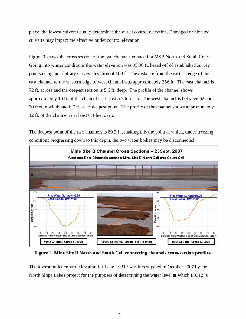
Figure 3 shows the cross section of the two channels connecting MSB North and South Cells.
Going into winter conditions the water elevation was 95.90 ft. based off of established survey
points using an arbitrary survey elevation of 100 ft. The distance from the eastern edge of the
east channel to the western edge of west channel was approximately 256 ft. The east channel is
72 ft. across and the deepest section is 5.6 ft. deep. The profile of the channel shows
approximately 16 ft. of the channel is at least 5.3 ft. deep. The west channel is between 62 and
70 feet in width and 6.7 ft. at its deepest point. The profile of the channel shows approximately
12 ft. of the channel is at least 6.4 feet deep.
The deepest point of the two channels is 89.2 ft., making this the point at which, under freezing
conditions progressing down to this depth, the two water bodies may be disconnected.
Figure 3. Mine Site B North and South Cell connecting channels cross-section profiles.
The lowest outlet control elevation for Lake L9312 was investigated in October 2007 by the
North Slope Lakes project for the purposes of determining the water level at which L9312 is
6
considered full. In September 2007 we further investigated the outlet channel to determine the
outlet control elevation in an unfrozen condition.
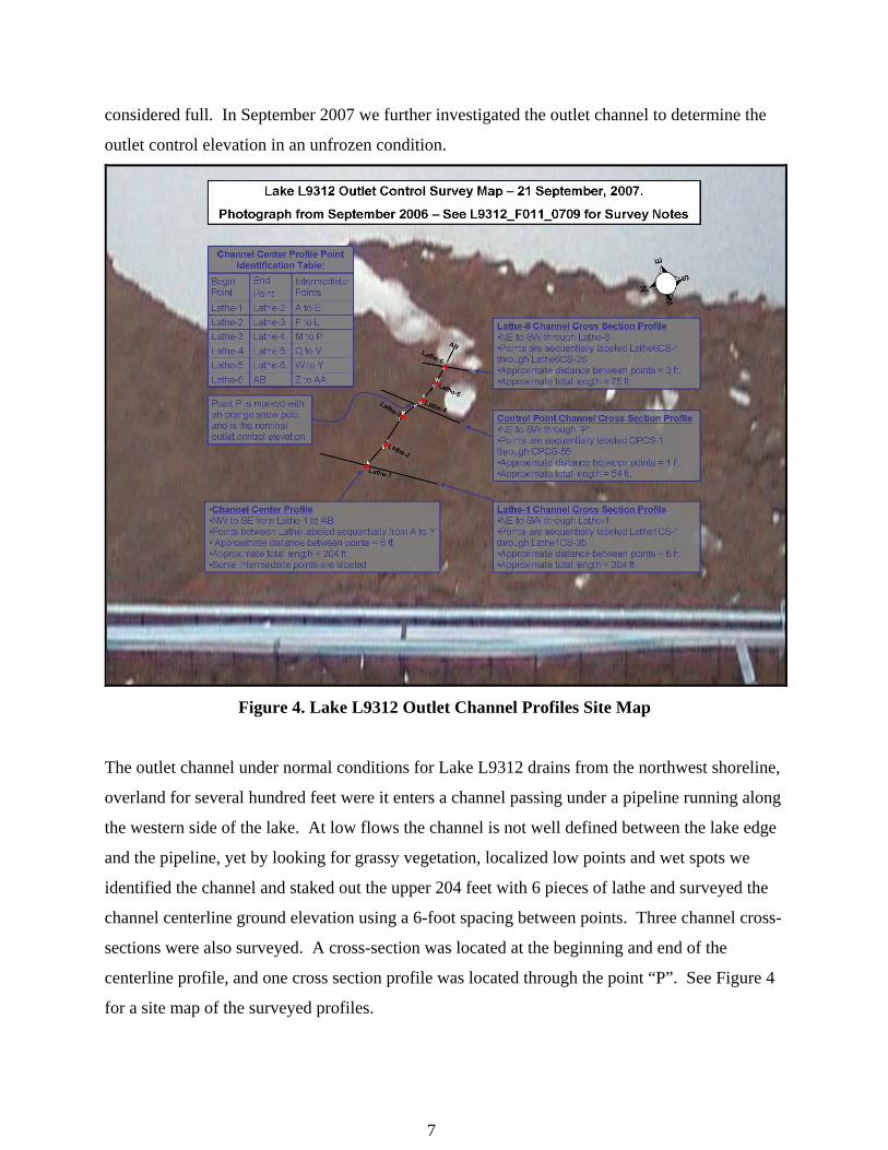
Figure 4. Lake L9312 Outlet Channel Profiles Site Map
The outlet channel under normal conditions for Lake L9312 drains from the northwest shoreline,
overland for several hundred feet were it enters a channel passing under a pipeline running along
the western side of the lake. At low flows the channel is not well defined between the lake edge
and the pipeline, yet by looking for grassy vegetation, localized low points and wet spots we
identified the channel and staked out the upper 204 feet with 6 pieces of lathe and surveyed the
channel centerline ground elevation using a 6-foot spacing between points. Three channel cross-
sections were also surveyed. A cross-section was located at the beginning and end of the
centerline profile, and one cross section profile was located through the point “P”. See Figure 4
for a site map of the surveyed profiles.
7

The centerline profile, shown in Figure 5, helps us identify 2 potential outlet control points,
labeled Point “F” and Point “P”. Point “F” was rejected as being observed to be downstream of
the outlet control point during overland flow conditions in May 2007. Point “P” coincided with
the previously identified outlet control point location and was accepted as the likely outlet
elevation control point. Point “F” and Point “P” differ by only 0.06’.
Figure 5 Lake L9312 outlet channel center-line profile. Point A-B is on the lake edge.
We also completed 3 channel cross-sections profiles. Lathe-6 and Lathe-1 cross-section profiles
are located near the beginning and end of the channel centerline profile to help define the
channel shape. The associated survey data is included in Appendix C. The outlet-control cross-
section profile, shown in Figure 6 passes through the identified outlet control point, Point “P”,
and extends into the tundra 15 feet to the NE and 29 feet to the SW with horizontal points
8
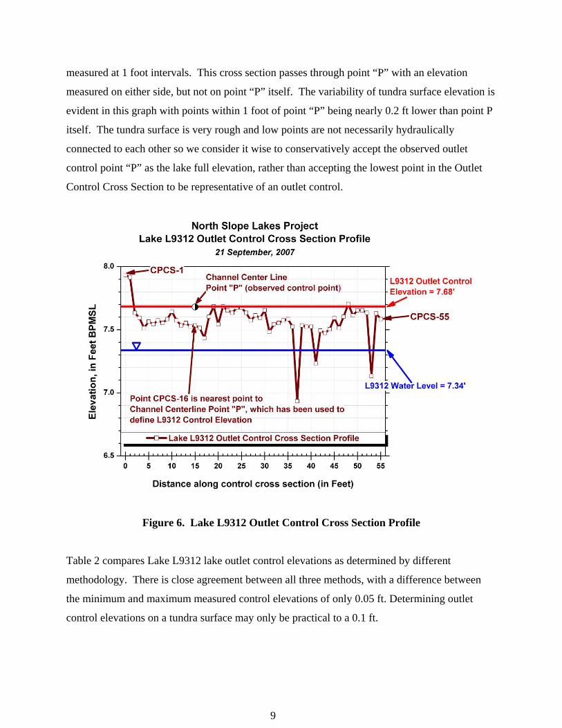
measured at 1 foot intervals. This cross section passes through point “P” with an elevation
measured on either side, but not on point “P” itself. The variability of tundra surface elevation is
evident in this graph with points within 1 foot of point “P” being nearly 0.2 ft lower than point P
itself. The tundra surface is very rough and low points are not necessarily hydraulically
connected to each other so we consider it wise to conservatively accept the observed outlet
control point “P” as the lake full elevation, rather than accepting the lowest point in the Outlet
Control Cross Section to be representative of an outlet control.
Figure 6. Lake L9312 Outlet Control Cross Section Profile
Table 2 compares Lake L9312 lake outlet control elevations as determined by different
methodology. There is close agreement between all three methods, with a difference between
the minimum and maximum measured control elevations of only 0.05 ft. Determining outlet
control elevations on a tundra surface may only be practical to a 0.1 ft.
9

Table 2. Lake L9312 Outlet Control Elevations, Method Comparison
Date Methodology Elevation (ft BPMSL)
10/27/2006 Level of frozen water surface backed up behind observed Outlet Control Point "P"
7.73
10/27/2006 Level of Lake L9312 after going into freeze up with no observed flow in outlet channel
7.70
9/21/2007 Elevation of thawed channel bottom at Outlet Control Point "P"
7.68
SUMMARY Understanding the physical hydrologic conditions and constraints going into freeze up, along
with continuous monitoring of water quality parameters and spatial distribution of snow cover at
North Slope lakes throughout the winter, will help in the understanding and development of
simulation tools necessary for water resource management. As water levels drop due to freezing
and pumping activities in the winter, it is important to identify the timing and depth of freezing
of the water column. Outlet control elevations can be used to better define full lake or reservoir
elevations. This information is necessary for permitting agencies as well as the industry
professionals who depend on this resource for facility use and ice road/pad construction.
Through monthly hydrologic assessments, water chemistry testing, and water sample analysis,
we will continue to answer some of the questions brought forth on the effects of mid-winter
pumping of North Slope tundra lakes.
REFERENCES
Lilly, M.R., Reichardt, D., Derry, J. 2007. A Workplan for Meteorological Station Maintenance,
Lake Chemistry Sampling, and Surveying at Study Lakes in Alpine, Kuparuk River, and
Prudhoe Bay Areas: September 2007. Water and Environmental Research Center,
University of Alaska Fairbanks. 16 pages.
10

11
White, D.M., and Lilly, M.R. 2007 a. BPX: Health, Safety, and Environmental Interface
Document. Water and Environmental Research Center, University of Alaska Fairbanks. 4
p.
White, D.M., and Lilly, M.R. 2007 b. BPX: Health, Safety, and Environmental Plan. Water and
Environmental Research Center, University of Alaska Fairbanks. 6 p.
White, D.M., and Lilly, M.R. 2007 c. ConocoPhillips Alaska, Inc.: Health, Safety, and
Environmental Plan. Water and Environmental Research Center, University of Alaska
Fairbanks. 5 p.

APPENDIX A. WATER QUALITY FIELD SAMPLING FORMS
The following forms report the data collected with the water quality meters during field
sampling.
A-1
Site Location/Lake ID:Sample Purpose: Date: 9/22/07 Time nr
Easting: Datum: NAD83Time: nr
Survey By: Date: 9/21/07 Time: 7:30na Date: na Time: na
23
OwnerUAF
10:29 10:30 10:31 10:31 10:32
1 3 5 7 93.03 3.05 3.04 3.04 3.027.30 7.32 7.34 7.35 7.36762.8 762.7 762.8 762.8 762.80.760 1.168 1.853 2.696 2.07345.76 45.74 45.73 45.73 75.7312.60 12.60 12.63 12.62 12.620.9 1.5 0.9 0.9 0.7245 245 244 244 243
FIELD TESTING OF WATER SAMPLES (if small probe is used)Probe: Depth (ft)Temp (°C)pHEh
NORTH SLOPE LAB CHEMISTRY ANALYSISMethod
Remarks:
Field-Form Filled Out By: Date:QAQC Check By: J. Derry Date:
University of Alaska Fairbanks, Water and Environmental Research CenterForm F-004a: Water Quality Field-Sampling GeneralProject ID: North Slope Lakes L9312 Raft B
Lake Water Quality
FIELD MEASUREMENTSGPS Coord. Northing: N70o19.995' W150o56.918'Measurements By: DARWater Depth (ft): nr
Elev. (BPMSL): 7.34 DAR
Ice Thickness (ft): 0.00Freeboard (ft): na Snow Depth (ft): 0.00
Calibration Information
Parameter (s) Meter Make/Model
Water Sampling By: na Sample Depths BWS (ft): 1
WATER QUALITY METER INFORMATION
Post-SamplingQAQC Check
MULTI IN-SITU TROLL 9000 PassSerial No.
Pre-SamplingQAQC Check
33205 PASS
Parameters
Time:
Field Measurements
Depth BWS (ft):Temp (°C):pH:Barometeric (mmHg):
ORP
Pressure (kPa):Conductivity (ųS/cm):RDO (ppm): (mg/L)Turbidity (NTU):
Parameter Depth BWS (ft):_______ Depth BWS (ft):____ Depth BWS (ft):______
Alkalinity (mg/L as CaCO3)
Total iron--UF (mg/L)
Filtered Iron--F tot Fe (mg/L)
10/25/07A. Blackburn 10/8/07
Sampling done from boat. Lake is ice free. 32 degree F. Wind is 20 mph from the East.
A-2

Site Location/Lake ID:Sample Purpose: Date: 9/26/07 Time: 18:05
Easting: Datum: NAD83Time: 19:00
Survey By: Date: 9/24/07 Time: 14:30na Date: na Time: na
23
OwnerUAF
18:07
6"2.018.13
--
131.512.49195.0
FIELD TESTING OF WATER SAMPLES (if small probe is used)Probe: Depth (ft)Temp (°C)pHEh
NORTH SLOPE LAB CHEMISTRY ANALYSISMethod
rep 1 rep 2 rep 3 rep 1 rep 2 rep 3 rep 1 rep 2 rep 3Hach spec0.3-15 mg/LDigital titrator10-4000 mg/L as CaCO3
Hach spec0.02-3.00 mg/LHach spec0.02-3.00 mg/L0.01-0.50 mg/L NH3-N
Remarks:
Field-Form Filled Out By: Date:QAQC Check By: Date:
University of Alaska Fairbanks, Water and Environmental Research CenterForm F-004a: Water Quality Field-Sampling GeneralProject ID: North Slope Lakes MSBS-SW
Lake Water Quality
FIELD MEASUREMENTSGPS Coord. Northing: N70o19.186' W149o24.234'Measurements By: DARWater Depth (ft): nr Ice Thickness (ft): 0.00Freeboard (ft): 0.00 Snow Depth (ft): 0.00Elev. (BPMSL +/- .02): 95.90 DAR, GMWater Sampling By: na Sample Depths BWS (ft): 1
WATER QUALITY METER INFORMATIONCalibration Information
Parameter (s) Meter Make/Model Serial No.Pre-SamplingQAQC Check
Post-SamplingQAQC Check
MULTI IN-SITU TROLL 9000 33205 PASS Pass
Parameters Field Measurements
Time:
Depth BWS (in):Temp (°C):pH:Barometeric (mmHg):Pressure (kPa):Conductivity (ųS/cm):RDO (ppm): (mg/L)Turbidity (NTU):ORP
Parameter Depth BWS (ft):_____ Depth BWS (ft):_____ Depth BWS (ft):_____
Oxygen (mg/L)
Alkalinity (mg/L as CaCO3)
Total iron--UF (mg/L)
Filtered Iron--F tot Fe (mg/L)Ammonia (mg/L NH3-N)****
Ammonia/ Iron dilution
J. Derry 10/25/07
Sampling done on SW side of MSBS from the shore.
A. Blackburn 10/8/07
A-3
Site Location/Lake ID:Sample Purpose: Date: 9/26/07 Time: 18:05
Easting: Datum: NAD83Time: 19:00
Survey By: Date: 9/24/07 Time: 14:30na Date: na Time: na
23
OwnerUAF
18:05
6"2.198.11
--
130.211.58175.0
FIELD TESTING OF WATER SAMPLES (if small probe is used)Probe: Depth (ft)Temp (°C)pHEh
NORTH SLOPE LAB CHEMISTRY ANALYSISMethod
rep 1 rep 2 rep 3 rep 1 rep 2 rep 3 rep 1 rep 2 rep 3Hach spec0.3-15 mg/LDigital titrator10-4000 mg/L as CaCO3
Hach spec0.02-3.00 mg/LHach spec0.02-3.00 mg/L0.01-0.50 mg/L NH3-N
Remarks:
Field-Form Filled Out By: Date:QAQC Check By: Date:
University of Alaska Fairbanks, Water and Environmental Research CenterForm F-004a: Water Quality Field-Sampling GeneralProject ID: North Slope Lakes MSBS-E
Lake Water Quality
FIELD MEASUREMENTSGPS Coord. Northing: N70o19.186' W149o24.234'Measurements By: DARWater Depth (ft): nr Ice Thickness (ft): 0.00Freeboard (ft): 0.00 Snow Depth (ft): 0.00Elev. (BPMSL +/- .02): 95.90 DAR, GMWater Sampling By: na Sample Depths BWS (ft): 1
WATER QUALITY METER INFORMATIONCalibration Information
Parameter (s) Meter Make/Model Serial No.Pre-SamplingQAQC Check
Post-SamplingQAQC Check
MULTI IN-SITU TROLL 9000 33205 PASS Pass
Parameters Field Measurements
Time:
Depth BWS (in):Temp (°C):pH:Barometeric (mmHg):Pressure (kPa):Conductivity (ųS/cm):RDO (ppm): (mg/L)Turbidity (NTU):ORP
Parameter Depth BWS (ft):_____ Depth BWS (ft):_____ Depth BWS (ft):_____
Oxygen (mg/L)
Alkalinity (mg/L as CaCO3)
Total iron--UF (mg/L)
Filtered Iron--F tot Fe (mg/L)Ammonia (mg/L NH3-N)****
Ammonia/ Iron dilution
J. Derry 10/25/07
Sampling done on E side of MSBS from the shore
A. Blackburn 10/8/07
A-4
Site Location/Lake ID:Sample Purpose: Date: 9/26/07 Time: 18:00
Easting: Datum: NAD83Time: 19:00
Survey By: Date: 9/24/07 Time: 14:30na Date: na Time: na
23
OwnerUAF
18:00
6"2.558.22
--
133.111.03159.0
FIELD TESTING OF WATER SAMPLES (if small probe is used)Probe: Depth (ft)Temp (°C)pHEh
NORTH SLOPE LAB CHEMISTRY ANALYSISMethod
rep 1 rep 2 rep 3 rep 1 rep 2 rep 3 rep 1 rep 2 rep 3Hach spec0.3-15 mg/LDigital titrator10-4000 mg/L as CaCO3Hach spec0.02-3.00 mg/LHach spec0.02-3.00 mg/Lp0.01-0.50 mg/L NH3-N
Remarks:
Field-Form Filled Out By: Date:QAQC Check By: Date:
MSBN-NE
10/8/07
Depth BWS (ft):_____
Post-SamplingQAQC Check
33205 Pass
Field Measurements
Depth BWS (ft):_____
Meter Make/ModelIN-SITU TROLL 9000
Depth BWS (ft):_____
Lake Water Quality
nr Ice Thickness (ft):
FIELD MEASUREMENTSGPS Coord. Northing: N70o19.186'
Form F-004a: Water Quality Field-Sampling GeneralProject ID: North Slope Lakes
University of Alaska Fairbanks, Water and Environmental Research Center
W149o24.234'Measurements By: DAR
Water Sampling By: naElev. (BPMSL +/- .02): 95.90
0.000.00 Snow Depth (ft):
DAR, GM
Water Depth (ft):Freeboard (ft):
Parameter (s) Serial No.
Sample Depths BWS (ft): 1
WATER QUALITY METER INFORMATIONCalibration Information
0.00
Pre-SamplingQAQC Check
MULTI PASS
Turbidity (NTU):
Depth BWS (in):Temp (°C):pH:Barometeric (mmHg):Pressure (kPa):Conductivity (ųS/cm):RDO (ppm): (mg/L)
Parameters
Time:
Alkalinity (mg/L as CaCO3)
ORP
Parameter
Oxygen (mg/L)
J. Derry
Total iron--UF (mg/L)
Filtered Iron--F tot Fe (mg/L)Ammonia (mg/L NH3-N)****
A. Blackburn
Ammonia/ Iron dilution
Sampling done on NE side of MSBN from the shore
10/25/07
A-5
APPENDIX B. WATER QUALITY METER CALIBRATION FORMS
The following forms report the pre- and post-calibration checks for the water quality meters
used during field sampling.
B-1
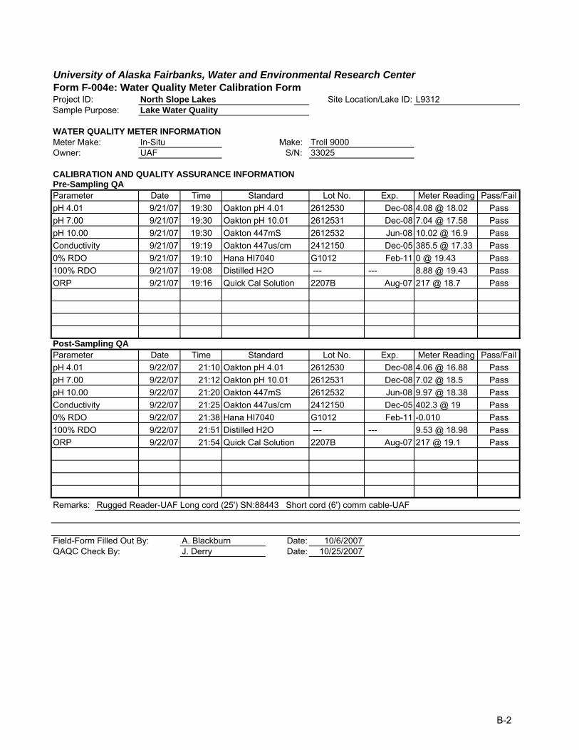
University of Alaska Fairbanks, Water and Environmental Research CenterForm F-004e: Water Quality Meter Calibration FormProject ID: North Slope Lakes Site Location/Lake ID: L9312Sample Purpose: Lake Water Quality
WATER QUALITY METER INFORMATIONMeter Make: In-Situ Make: Troll 9000Owner: UAF S/N: 33025
CALIBRATION AND QUALITY ASSURANCE INFORMATIONPre-Sampling QAParameter Date Time Standard Lot No. Exp. Meter Reading Pass/FailpH 4.01 9/21/07 19:30 Oakton pH 4.01 2612530 Dec-08 4.08 @ 18.02 PasspH 7.00 9/21/07 19:30 Oakton pH 10.01 2612531 Dec-08 7.04 @ 17.58 PasspH 10.00 9/21/07 19:30 Oakton 447mS 2612532 Jun-08 10.02 @ 16.9 PassConductivity 9/21/07 19:19 Oakton 447us/cm 2412150 Dec-05 385.5 @ 17.33 Pass0% RDO 9/21/07 19:10 Hana HI7040 G1012 Feb-11 0 @ 19.43 Pass100% RDO 9/21/07 19:08 Distilled H2O --- --- 8.88 @ 19.43 PassORP 9/21/07 19:16 Quick Cal Solution 2207B Aug-07 217 @ 18.7 Pass
Post-Sampling QAParameter Date Time Standard Lot No. Exp. Meter Reading Pass/FailpH 4.01 9/22/07 21:10 Oakton pH 4.01 2612530 Dec-08 4.06 @ 16.88 PasspH 7.00 9/22/07 21:12 Oakton pH 10.01 2612531 Dec-08 7.02 @ 18.5 PasspH 10.00 9/22/07 21:20 Oakton 447mS 2612532 Jun-08 9.97 @ 18.38 PassConductivity 9/22/07 21:25 Oakton 447us/cm 2412150 Dec-05 402.3 @ 19 Pass0% RDO 9/22/07 21:38 Hana HI7040 G1012 Feb-11 -0.010 Pass100% RDO 9/22/07 21:51 Distilled H2O --- --- 9.53 @ 18.98 PassORP 9/22/07 21:54 Quick Cal Solution 2207B Aug-07 217 @ 19.1 Pass
Remarks: Rugged Reader-UAF Long cord (25') SN:88443 Short cord (6') comm cable-UAF
Field-Form Filled Out By: A. Blackburn Date: 10/6/2007QAQC Check By: J. Derry Date: 10/25/2007
B-2

University of Alaska Fairbanks, Water and Environmental Research CenterForm F-004e: Water Quality Meter Calibration FormProject ID: North Slope Lakes Site Location/Lake ID: MSBSample Purpose: Lake Water Quality
WATER QUALITY METER INFORMATIONMeter Make: In-Situ Make: Troll 9000Owner: UAF S/N: 33025
CALIBRATION AND QUALITY ASSURANCE INFORMATIONPre-Sampling QAParameter Date Time Standard Lot No. Exp. Meter Reading Pass/FailpH 4.01 9/23/07 10:58 Oakton pH 4.01 2612530 Dec-08 4.03 @ 15.33 PasspH 7.00 9/23/07 10:55 Oakton pH 10.01 2612531 Dec-08 7.00 @ 15.16 PasspH 10.00 9/23/07 11:01 Oakton 447mS 2612532 Jun-08 10.06 @ 15.38 PassConductivity 9/23/07 10:49 Oakton 447us/cm 2412150 Dec-05 351.8 @ 14.3 Pass0% RDO 9/23/07 11:11 Hana HI7040 G1012 Feb-11 0.01 @ 14.81 Pass100% RDO 9/23/07 10:48 Distilled H2O --- --- 10.09 @ 14.24 PassORP 9/23/07 10:53 Quick Cal Solution 2207B Aug-07 219 @ 15.2 Pass
Post-Sampling QAParameter Date Time Standard Lot No. Exp. Meter Reading Pass/FailpH 4.01 9/26/07 20:21 Oakton pH 4.01 2612530 Dec-08 4.04 @ 14.8 PasspH 7.00 9/26/07 20:25 Oakton pH 10.01 2612531 Dec-08 7.01 @ 14.9 PasspH 10.00 9/26/07 20:31 Oakton 447mS 2612532 Jun-08 10.05 @ 14.8 PassConductivity 9/26/07 20:09 Oakton 447us/cm 2412150 Dec-05 350.2 @ 14.8 Pass0% RDO 9/26/07 20:37 Hana HI7040 G1012 Feb-11 0 @ 14.8 Pass100% RDO 9/26/07 20:05 Distilled H2O --- --- 10.03 @ 14.79 PassORP 9/26/07 20:15 Quick Cal Solution 2207B Aug-07 223 @ 14.9 Pass
Remarks:
Field-Form Filled Out By: A. Blackburn Date: 10/6/2007QAQC Check By: J. Derry Date: 10/25/2007
B-3

APPENDIX C. ELEVATION SURVEY FORMS
The following form reports the elevation survey information obtained during field sampling.
C-1
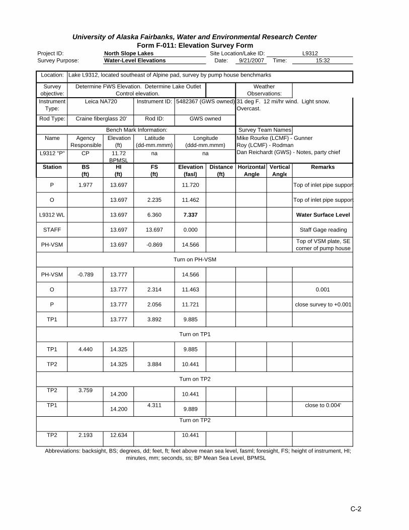
North Slope LakesSurvey Purpose: Water-Level Elevations Date: 9/21/2007 Time: 15:32
Location:
Survey objective:
InstrumentType:
Instrument ID:
Rod Type: Rod ID:
Name Agency Responsible
Elevation(ft)
Latitude(dd-mm.mmm)
L9312 "P" CP 11.72 BPMSL
na
Station BS(ft)
HI(ft)
FS(ft)
Elevation(fasl)
Distance(ft)
Horizontal Angle
Vertical Angle
Remarks
P 1.977 13.697 11.720 Top of inlet pipe support
O 13.697 2.235 11.462 Top of inlet pipe support
L9312 WL 13.697 6.360 7.337 Water Surface Level
STAFF 13.697 13.697 0.000 Staff Gage reading
PH-VSM 13.697 -0.869 14.566 Top of VSM plate, SE corner of pump house
PH-VSM -0.789 13.777 14.566
O 13.777 2.314 11.463 0.001
P 13.777 2.056 11.721 close survey to +0.001
TP1 13.777 3.892 9.885
TP1 4.440 14.325 9.885
TP2 14.325 3.884 10.441
TP2 3.75914.200 10.441
TP114.200
4.3119.889
close to 0.004'
TP2 2.193 12.634 10.441
University of Alaska Fairbanks, Water and Environmental Research CenterForm F-011: Elevation Survey Form
Project ID: Site Location/Lake ID: L9312
Lake L9312, located southeast of Alpine pad, survey by pump house benchmarks
Longitude(ddd-mm.mmm)
Survey Team NamesMike Rourke (LCMF) - Gunner Roy (LCMF) - Rodman Dan Reichardt (GWS) - Notes, party chief
Bench Mark Information:
na
Craine fiberglass 20' GWS owned
Weather Observations:
Determine FWS Elevation. Determine Lake Outlet Control elevation.
Abbreviations: backsight, BS; degrees, dd; feet, ft; feet above mean sea level, fasml; foresight, FS; height of instrument, HI; minutes, mm; seconds, ss; BP Mean Sea Level, BPMSL
31 deg F. 12 mi/hr wind. Light snow. Overcast.
Turn on PH-VSM
Leica NA720
Turn on TP1
Turn on TP2
Turn on TP2
5482367 (GWS owned)
C-2
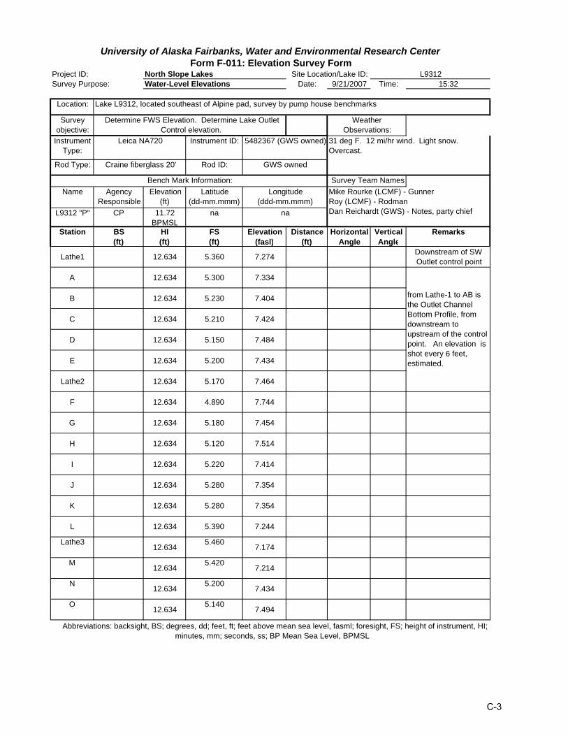
North Slope LakesSurvey Purpose: Water-Level Elevations Date: 9/21/2007 Time: 15:32
Location:
Survey objective:
InstrumentType:
Instrument ID:
Rod Type: Rod ID:
Name Agency Responsible
Elevation(ft)
Latitude(dd-mm.mmm)
L9312 "P" CP 11.72 BPMSL
na
Station BS(ft)
HI(ft)
FS(ft)
Elevation(fasl)
Distance(ft)
Horizontal Angle
Vertical Angle
Remarks
Lathe1 12.634 5.360 7.274 Downstream of SW Outlet control point
A 12.634 5.300 7.334
B 12.634 5.230 7.404
C 12.634 5.210 7.424
D 12.634 5.150 7.484
E 12.634 5.200 7.434
Lathe2 12.634 5.170 7.464
F 12.634 4.890 7.744
G 12.634 5.180 7.454
H 12.634 5.120 7.514
I 12.634 5.220 7.414
J 12.634 5.280 7.354
K 12.634 5.280 7.354
L 12.634 5.390 7.244
Lathe312.634
5.4607.174
M12.634
5.4207.214
N12.634
5.2007.434
O12.634
5.1407.494
Abbreviations: backsight, BS; degrees, dd; feet, ft; feet above mean sea level, fasml; foresight, FS; height of instrument, HI; minutes, mm; seconds, ss; BP Mean Sea Level, BPMSL
31 deg F. 12 mi/hr wind. Light snow. Overcast.
Leica NA720
from Lathe-1 to AB is the Outlet Channel Bottom Profile, from downstream to upstream of the control point. An elevation is shot every 6 feet, estimated.
5482367 (GWS owned)
Lake L9312, located southeast of Alpine pad, survey by pump house benchmarks
Longitude(ddd-mm.mmm)
Survey Team NamesMike Rourke (LCMF) - Gunner Roy (LCMF) - Rodman Dan Reichardt (GWS) - Notes, party chief
Bench Mark Information:
na
Craine fiberglass 20' GWS owned
Weather Observations:
Determine FWS Elevation. Determine Lake Outlet Control elevation.
University of Alaska Fairbanks, Water and Environmental Research CenterForm F-011: Elevation Survey Form
Project ID: Site Location/Lake ID: L9312
C-3

North Slope LakesSurvey Purpose: Water-Level Elevations Date: 9/21/2007 Time: 15:32
Location:
Survey objective:
InstrumentType:
Instrument ID:
Rod Type: Rod ID:
Name Agency Responsible
Elevation(ft)
Latitude(dd-mm.mmm)
L9312 "P" CP 11.72 BPMSL
na
Station BS(ft)
HI(ft)
FS(ft)
Elevation(fasl)
Distance(ft)
Horizontal Angle
Vertical Angle
Remarks
P 12.634 4.950 7.684 Outlet Control Point
Q 12.634 5.000 7.634
Lathe4 12.634 5.000 7.634
TP2 12.634 2.195 10.439 -0.004
R 12.634 5.050 7.584
S 12.634 5.040 7.594
T 12.634 5.160 7.474
U 12.634 5.180 7.454
V 12.634 5.180 7.454
Lathe5 12.634 5.080 7.554
W 12.634 5.050 7.584
X 12.634 5.030 7.604
Y 12.634 4.980 7.654
Lathe6 12.634 5.190 7.444
Z12.634
5.2107.424
AZ12.634
5.3907.244
Channel at edge of lakenot water surface.
AA12.634
7.6105.024
2.2' Below Water Level
AB12.634
7.6404.994
2.3' Below Water Level
University of Alaska Fairbanks, Water and Environmental Research CenterForm F-011: Elevation Survey Form
Project ID: Site Location/Lake ID: L9312
Lake L9312, located southeast of Alpine pad, survey by pump house benchmarks
Longitude(ddd-mm.mmm)
Survey Team NamesMike Rourke (LCMF) - Gunner Roy (LCMF) - Rodman Dan Reichardt (GWS) - Notes, party chief
Bench Mark Information:
na
Craine fiberglass 20' GWS owned
Weather Observations:
Determine FWS Elevation. Determine Lake Outlet Control elevation.
Abbreviations: backsight, BS; degrees, dd; feet, ft; feet above mean sea level, fasml; foresight, FS; height of instrument, HI; minutes, mm; seconds, ss; BP Mean Sea Level, BPMSL
31 deg F. 12 mi/hr wind. Light snow. Overcast.
Leica NA720 5482367 (GWS owned)
C-4
North Slope LakesSurvey Purpose: Water-Level Elevations Date: 9/21/2007 Time: 15:32
Location:
Survey objective:
InstrumentType:
Instrument ID:
Rod Type: Rod ID:
Name Agency Responsible
Elevation(ft)
Latitude(dd-mm.mmm)
L9312 "P" CP 11.72 BPMSL
na
Station BS(ft)
HI(ft)
FS(ft)
Elevation(fasl)
Distance(ft)
Horizontal Angle
Vertical Angle
Remarks
TP2 12.634 2.189 10.445 0.004'
TP2 12.634 2.194 10.440 -0.001
CPCS-1 12.634 4.700 7.934
CPCS-2 12.634 4.720 7.914
CPCS-3 12.634 5.000 7.634
CPCS-4 12.634 5.040 7.594
CPCS-5 12.634 5.120 7.514
CPCS-6 12.634 5.070 7.564
CPCS-7 12.634 5.090 7.544
CPCS-8 12.634 5.060 7.574
CPCS-9 12.634 5.080 7.554
CPCS-10 12.634 5.050 7.584
CPCS-11 12.634 4.990 7.644
CPCS-12 12.6345.060
7.574
CPCS-13 12.6345.100
7.534
CPCS-14 12.6345.080
7.554
CPCS-15 12.6345.110
7.524
Abbreviations: backsight, BS; degrees, dd; feet, ft; feet above mean sea level, fasml; foresight, FS; height of instrument, HI; minutes, mm; seconds, ss; BP Mean Sea Level, BPMSL
31 deg F. 12 mi/hr wind. Light snow. Overcast.
Leica NA720 5482367 (GWS owned)
Fine tune level of Instrument
CPCS-1 through CPCS-55 is the cross section of the channel from NE to SW through the outlet control point. Total cross section length is 54'. Interval between shots is 1', measured with nylon tape. The cross sectionis approximately perpendicular to the channel
Lake L9312, located southeast of Alpine pad, survey by pump house benchmarks
Longitude(ddd-mm.mmm)
Survey Team NamesMike Rourke (LCMF) - Gunner Roy (LCMF) - Rodman Dan Reichardt (GWS) - Notes, party chief
Bench Mark Information:
na
Craine fiberglass 20' GWS owned
Weather Observations:
Determine FWS Elevation. Determine Lake Outlet Control elevation.
University of Alaska Fairbanks, Water and Environmental Research CenterForm F-011: Elevation Survey Form
Project ID: Site Location/Lake ID: L9312
C-5

North Slope LakesSurvey Purpose: Water-Level Elevations Date: 9/21/2007 Time: 15:32
Location:
Survey objective:
InstrumentType:
Instrument ID:
Rod Type: Rod ID:
Name Agency Responsible
Elevation(ft)
Latitude(dd-mm.mmm)
L9312 "P" CP 11.72 BPMSL
na
Station BS(ft)
HI(ft)
FS(ft)
Elevation(fasl)
Distance(ft)
Horizontal Angle
Vertical Angle
Remarks
CPCS-16 12.634 5.100 7.534 Nearest point to outlet control point "P"
CPCS-17 12.634 5.120 7.514
CPCS-18 12.634 5.200 7.434
CPCS-19 12.634 5.030 7.604
CPCS-20 12.634 4.950 7.684
CPCS-21 12.634 5.090 7.544
CPCS-22 12.634 4.950 7.684
CPCS-23 12.634 4.980 7.654
CPCS-24 12.634 5.000 7.634
CPCS-25 12.634 4.960 7.674
CPCS-26 12.634 4.960 7.674
CPCS-27 12.634 5.000 7.634
CPCS-28 12.634 5.060 7.574
CPCS-29 12.634 5.020 7.614
CPCS-30 12.6345.040
7.594
CPCS-31 12.6344.980
7.654
CPCS-32 12.6345.150
7.484
CPCS-33 12.6345.090
7.544
University of Alaska Fairbanks, Water and Environmental Research CenterForm F-011: Elevation Survey Form
Project ID: Site Location/Lake ID: L9312
Lake L9312, located southeast of Alpine pad, survey by pump house benchmarks
Longitude(ddd-mm.mmm)
Survey Team NamesMike Rourke (LCMF) - Gunner Roy (LCMF) - Rodman Dan Reichardt (GWS) - Notes, party chief
Bench Mark Information:
na
Craine fiberglass 20' GWS owned
Weather Observations:
Determine FWS Elevation. Determine Lake Outlet Control elevation.
Abbreviations: backsight, BS; degrees, dd; feet, ft; feet above mean sea level, fasml; foresight, FS; height of instrument, HI; minutes, mm; seconds, ss; BP Mean Sea Level, BPMSL
31 deg F. 12 mi/hr wind. Light snow. Overcast.
Leica NA720 5482367 (GWS owned)
C-6

North Slope LakesSurvey Purpose: Water-Level Elevations Date: 9/21/2007 Time: 15:32
Location:
Survey objective:
InstrumentType:
Instrument ID:
Rod Type: Rod ID:
Name Agency Responsible
Elevation(ft)
Latitude(dd-mm.mmm)
L9312 "P" CP 11.72 BPMSL
na
Station BS(ft)
HI(ft)
FS(ft)
Elevation(fasl)
Distance(ft)
Horizontal Angle
Vertical Angle
Remarks
CPCS-34 12.634 5.080 7.554
CPCS-35 12.634 5.060 7.574
CPCS-36 12.634 5.050 7.584
CPCS-37 12.634 5.110 7.524
CPCS-38 12.634 5.700 6.934
CPCS-39 12.634 5.100 7.534
CPCS-40 12.634 5.110 7.524
CPCS-41 12.634 5.110 7.524
CPCS-42 12.634 5.400 7.234
CPCS-43 12.634 5.140 7.494
CPCS-44 12.634 5.160 7.474
CPCS-45 12.634 5.130 7.504
CPCS-46 12.634 5.040 7.594
CPCS-47 12.634 5.120 7.514
CPCS-48 12.6345.030
7.604
CPCS-49 12.6344.930
7.704
CPCS-50 12.6345.020
7.614
CPCS-51 12.6344.980
7.654
Abbreviations: backsight, BS; degrees, dd; feet, ft; feet above mean sea level, fasml; foresight, FS; height of instrument, HI; minutes, mm; seconds, ss; BP Mean Sea Level, BPMSL
31 deg F. 12 mi/hr wind. Light snow. Overcast.
Leica NA720 5482367 (GWS owned)
Lake L9312, located southeast of Alpine pad, survey by pump house benchmarks
Longitude(ddd-mm.mmm)
Survey Team NamesMike Rourke (LCMF) - Gunner Roy (LCMF) - Rodman Dan Reichardt (GWS) - Notes, party chief
Bench Mark Information:
na
Craine fiberglass 20' GWS owned
Weather Observations:
Determine FWS Elevation. Determine Lake Outlet Control elevation.
University of Alaska Fairbanks, Water and Environmental Research CenterForm F-011: Elevation Survey Form
Project ID: Site Location/Lake ID: L9312
C-7
North Slope LakesSurvey Purpose: Water-Level Elevations Date: 9/21/2007 Time: 15:32
Location:
Survey objective:
InstrumentType:
Instrument ID:
Rod Type: Rod ID:
Name Agency Responsible
Elevation(ft)
Latitude(dd-mm.mmm)
L9312 "P" CP 11.72 BPMSL
na
Station BS(ft)
HI(ft)
FS(ft)
Elevation(fasl)
Distance(ft)
Horizontal Angle
Vertical Angle
Remarks
CPCS-51 12.634 4.980 7.654
CPCS-52 12.634 5.000 7.634
CPCS-53 12.634 5.500 7.134
CPCS-54 12.634 5.005 7.629
CPCS-55 12.634 5.050 7.584
Lathe6CS-1 12.634 4.790 7.844
Lathe6CS-2 12.634 4.880 7.754
Lathe6CS-3 12.634 4.950 7.684
Lathe6CS-4 12.634 4.990 7.644
Lathe6CS-5 12.634 4.950 7.684
Lathe6CS-6 12.634 5.040 7.594
Lathe6CS-7 12.634 5.030 7.604
Lathe6CS-8 12.634 5.050 7.584
Lathe6CS-9 12.634 5.240 7.394
Lathe6 12.6345.230
7.404 0.040' lower than from channel center profile
Lathe6CS-11 12.634
5.0907.544
Lathe6CS-12 12.634
4.9807.654
Lathe6CS-13 12.634
5.0407.594
University of Alaska Fairbanks, Water and Environmental Research CenterForm F-011: Elevation Survey Form
Project ID: Site Location/Lake ID: L9312
Lake L9312, located southeast of Alpine pad, survey by pump house benchmarks
Longitude(ddd-mm.mmm)
Survey Team NamesMike Rourke (LCMF) - Gunner Roy (LCMF) - Rodman Dan Reichardt (GWS) - Notes, party chief
Bench Mark Information:
na
Craine fiberglass 20' GWS owned
Weather Observations:
Determine FWS Elevation. Determine Lake Outlet Control elevation.
Abbreviations: backsight, BS; degrees, dd; feet, ft; feet above mean sea level, fasml; foresight, FS; height of instrument, HI; minutes, mm; seconds, ss; BP Mean Sea Level, BPMSL
31 deg F. 12 mi/hr wind. Light snow. Overcast.
Leica NA720 5482367 (GWS owned)
Lathe6CS-1 to Lathe6CS-26 is channelcross section from NE to SW through Lathe-6. Shot interval is 6 feet, approximately.
C-8
North Slope LakesSurvey Purpose: Water-Level Elevations Date: 9/21/2007 Time: 15:32
Location:
Survey objective:
InstrumentType:
Instrument ID:
Rod Type: Rod ID:
Name Agency Responsible
Elevation(ft)
Latitude(dd-mm.mmm)
L9312 "P" CP 11.72 BPMSL
na
Station BS(ft)
HI(ft)
FS(ft)
Elevation(fasl)
Distance(ft)
Horizontal Angle
Vertical Angle
Remarks
Lathe6CS-14 12.634 4.870 7.764
Lathe6CS-15 12.634 5.150 7.484
Lathe6CS-16 12.634 5.140 7.494
Lathe6CS-17 12.634 5.020 7.614
Lathe6CS-18 12.634 5.100 7.534
Lathe6CS-19 12.634 5.140 7.494
Lathe6CS-20 12.634 5.160 7.474
Lathe6CS-21 12.634 5.100 7.534
Lathe6CS-22 12.634 5.050 7.584
Lathe6CS-23 12.634 4.840 7.794
Lathe6CS-24 12.634 5.030 7.604
Lathe6CS-25 12.634 4.980 7.654
Lathe6CS-26 12.634 4.880 7.754
Lathe1CS-1 12.634 5.230 7.404
Lathe1CS-2 12.6345.270
7.364
Lathe1CS-3 12.6345.250
7.384
Lathe1CS-4 12.6345.200
7.434
Lathe1CS-5 12.6345.120
7.514
Abbreviations: backsight, BS; degrees, dd; feet, ft; feet above mean sea level, fasml; foresight, FS; height of instrument, HI; minutes, mm; seconds, ss; BP Mean Sea Level, BPMSL
31 deg F. 12 mi/hr wind. Light snow. Overcast.
Leica NA720 5482367 (GWS owned)
Lathe1CS-1 to Lathe1CS-35 is channelcross section from NE to SW through Lathe-1. Shot interval is 3 feet, approximately.
Lake L9312, located southeast of Alpine pad, survey by pump house benchmarks
Longitude(ddd-mm.mmm)
Survey Team NamesMike Rourke (LCMF) - Gunner Roy (LCMF) - Rodman Dan Reichardt (GWS) - Notes, party chief
Bench Mark Information:
na
Craine fiberglass 20' GWS owned
Weather Observations:
Determine FWS Elevation. Determine Lake Outlet Control elevation.
University of Alaska Fairbanks, Water and Environmental Research CenterForm F-011: Elevation Survey Form
Project ID: Site Location/Lake ID: L9312
C-9
North Slope LakesSurvey Purpose: Water-Level Elevations Date: 9/21/2007 Time: 15:32
Location:
Survey objective:
InstrumentType:
Instrument ID:
Rod Type: Rod ID:
Name Agency Responsible
Elevation(ft)
Latitude(dd-mm.mmm)
L9312 "P" CP 11.72 BPMSL
na
Station BS(ft)
HI(ft)
FS(ft)
Elevation(fasl)
Distance(ft)
Horizontal Angle
Vertical Angle
Remarks
Lathe1CS-6 12.634 5.260 7.374
Lathe1CS-7 12.634 5.130 7.504
Lathe1CS-8 12.634 5.130 7.504
Lathe1CS-9 12.634 5.340 7.294
Lathe1 12.634 5.560 7.074 0.200' lower than from channel center profile
Lathe1CS-11 12.634 5.030 7.604
Lathe1CS-12 12.634 5.090 7.544
Lathe1CS-13 12.634 4.950 7.684
Lathe1CS-14 12.634 5.160 7.474
Lathe1CS-15 12.634 5.100 7.534
Lathe1CS-16 12.634 5.110 7.524
Lathe1CS-17 12.634 5.120 7.514
Lathe1CS-18 12.634 5.210 7.424
Lathe1CS-19 12.634 5.110 7.524
Lathe1CS-20 12.634
5.1307.504
Lathe1CS-21 12.634
5.2707.364
Lathe1CS-22 12.634
5.1407.494
Lathe1CS-23 12.634
5.0507.584
University of Alaska Fairbanks, Water and Environmental Research CenterForm F-011: Elevation Survey Form
Project ID: Site Location/Lake ID: L9312
Lake L9312, located southeast of Alpine pad, survey by pump house benchmarks
Longitude(ddd-mm.mmm)
Survey Team NamesMike Rourke (LCMF) - Gunner Roy (LCMF) - Rodman Dan Reichardt (GWS) - Notes, party chief
Bench Mark Information:
na
Craine fiberglass 20' GWS owned
Weather Observations:
Determine FWS Elevation. Determine Lake Outlet Control elevation.
Abbreviations: backsight, BS; degrees, dd; feet, ft; feet above mean sea level, fasml; foresight, FS; height of instrument, HI; minutes, mm; seconds, ss; BP Mean Sea Level, BPMSL
31 deg F. 12 mi/hr wind. Light snow. Overcast.
Leica NA720 5482367 (GWS owned)
C-10
North Slope LakesSurvey Purpose: Water-Level Elevations Date: 9/21/2007 Time: 15:32
Location:
Survey objective:
InstrumentType:
Instrument ID:
Rod Type: Rod ID:
Name Agency Responsible
Elevation(ft)
Latitude(dd-mm.mmm)
L9312 "P" CP 11.72 BPMSL
na
Station BS(ft)
HI(ft)
FS(ft)
Elevation(fasl)
Distance(ft)
Horizontal Angle
Vertical Angle
Remarks
Lathe1CS-24 12.634 4.77 7.864
Lathe1CS-25 12.634 5.17 7.464
Lathe1CS-26 12.634 5.21 7.424
Lathe1CS-27 12.634 5.05 7.584
Lathe1CS-28 12.634 4.66 7.974
Lathe1CS-29 12.634 4.77 7.864
Lathe1CS-30 12.634 4.79 7.844
Lathe1CS-31 12.634 5.37 7.264
Lathe1CS-32 12.634 5.51 7.124
Lathe1CS-33 12.634 5.28 7.354
Lathe1CS-34 12.634 4.85 7.784
Lathe1CS-35 12.634 4.36 8.274
TP2 12.634 2.192 10.442 closes to +.001
Abbreviations: backsight, BS; degrees, dd; feet, ft; feet above mean sea level, fasml; foresight, FS; height of instrument, HI; minutes, mm; seconds, ss; BP Mean Sea Level, BPMSL
31 deg F. 12 mi/hr wind. Light snow. Overcast.
Leica NA720 5482367 (GWS owned)
Lake L9312, located southeast of Alpine pad, survey by pump house benchmarks
Longitude(ddd-mm.mmm)
Survey Team NamesMike Rourke (LCMF) - Gunner Roy (LCMF) - Rodman Dan Reichardt (GWS) - Notes, party chief
Bench Mark Information:
na
Craine fiberglass 20' GWS owned
Weather Observations:
Determine FWS Elevation. Determine Lake Outlet Control elevation.
University of Alaska Fairbanks, Water and Environmental Research CenterForm F-011: Elevation Survey Form
Project ID: Site Location/Lake ID: L9312
C-11
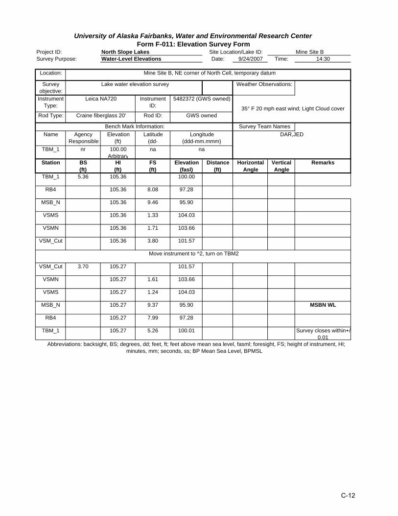
North Slope LakesSurvey Purpose: Water-Level Elevations Date: 9/24/2007 Time: 14:30
Location:
Survey objective:
InstrumentType:
Instrument ID:
Rod Type: Rod ID:
Name Agency Responsible
Elevation(ft)
Latitude(dd-
TBM_1 nr 100.00Arbitrary
na
Station BS(ft)
HI(ft)
FS(ft)
Elevation(fasl)
Distance(ft)
Horizontal Angle
Vertical Angle
Remarks
TBM_1 5.36 105.36 100.00
RB4 105.36 8.08 97.28
MSB_N 105.36 9.46 95.90
VSMS 105.36 1.33 104.03
VSMN 105.36 1.71 103.66
VSM_Cut 105.36 3.80 101.57
VSM_Cut 3.70 105.27 101.57
VSMN 105.27 1.61 103.66
VSMS 105.27 1.24 104.03
MSB_N 105.27 9.37 95.90 MSBN WL
RB4 105.27 7.99 97.28
TBM_1 105.27 5.26 100.01 Survey closes within+/0.01
Longitude(ddd-mm.mmm)
DAR,JED
na
Abbreviations: backsight, BS; degrees, dd; feet, ft; feet above mean sea level, fasml; foresight, FS; height of instrument, HI; minutes, mm; seconds, ss; BP Mean Sea Level, BPMSL
Move instrument to ^2, turn on TBM2
Craine fiberglass 20' GWS owned
Bench Mark Information: Survey Team Names
Mine Site B, NE corner of North Cell, temporary datum
Lake water elevation survey Weather Observations:
Leica NA720 5482372 (GWS owned)
35° F 20 mph east wind; Light Cloud cover
University of Alaska Fairbanks, Water and Environmental Research CenterForm F-011: Elevation Survey Form
Project ID: Site Location/Lake ID: Mine Site B
C-12

North Slope LakesSurvey Purpose: Water-Level Elevations Date: 9/24/2007 Time: 14:30
Location:
Survey objective:
InstrumentType:
Instrument ID:
Rod Type: Rod ID:
Name Agency Responsible
Elevation(ft)
Latitude(dd-
TBM_1 nr 100.00Arbitrary
na
Station BS(ft)
HI(ft)
FS(ft)
Elevation(fasl)
Distance(ft)
Horizontal Angle
Vertical Angle
Remarks
Top of Re-bar
4.97 102.36 97.39
Bottom of Re-bar
102.36 5.53 96.83
4 102.36 5.84 96.52
6 102.36 6.01 96.35
8 102.36 6.16 96.20
10 102.36 6.28 96.08
12 102.36 6.46 95.90 Water Surface
14 102.36 6.58 95.78
16 102.36 6.59 95.77
18 102.36 6.72 95.64
20 102.36 6.95 95.41
22 102.36 6.98 95.38
24 95.90 0.66 95.24
26 95.90 0.81 95.09
28 95.90 0.95 94.95
30 95.90 1.27 94.63
32 95.90 1.95 93.95
34 95.90 2.56 93.34
University of Alaska Fairbanks, Water and Environmental Research CenterForm F-011: Elevation Survey Form
Project ID: Site Location/Lake ID: MSB-East Channel Transect
Survey of the channel bottom of the eastern channel connecting MSB_S and MSB_N
Lake water elevation survey Weather Observations:
Leica NA720 5482372 (GWS owned) 13 Degrees F 25 mph wind clear, unrestricted
Craine fiberglass 20' GWS owned
Bench Mark Information: Survey Team NamesLongitude
(ddd-mm.mmm)DAR,JED
na
Abbreviations: backsight, BS; degrees, dd; feet, ft; feet above mean sea level, fasml; foresight, FS; height of instrument, Hminutes, mm; seconds, ss; BP Mean Sea Level, BPMSL
MSB_East Channel, start on east side of channel. Point of beginning is rebar 12 feet East of waters edge. Station # is feet from point of beginning. Starting at 24 feet, elevation is determined by measuring water depth with survey rod. Water surface elevation is known, and entered as HI. Depth is entered as FS
C-13

North Slope LakesSurvey Purpose: Water-Level Elevations Date: 9/25/2007 Time: 14:30
Location:
Survey objective:
InstrumentType:
Instrument ID:
Rod Type: Rod ID:
Name Agency Responsible
Elevation(ft)
Latitude(dd-
TBM_1 nr 100.00Arbitrary
na
Station BS(ft)
HI(ft)
FS(ft)
Elevation(fasl)
Distance(ft)
Horizontal Angle
Vertical Angle
Remarks
36 95.90 3.29 92.61
44 95.90 4.80 91.10
47 95.90 5.20 90.70
50 95.90 5.20 90.70
52 95.90 5.30 90.60
54 95.90 5.30 90.60
57 95.90 5.40 90.50
60 95.90 5.45 90.45
62 95.90 5.60 90.30
66 95.90 5.30 90.60
68 95.90 5.30 90.60
70 95.90 3.90 92.00
72 95.90 3.29 92.61
74 95.90 2.68 93.22
76 95.90 1.94 93.96
78 95.90 1.17 94.73
80 95.90 0.65 95.25
82 95.90 0.32 95.58
84 95.90 0.14 95.76
Longitude(ddd-mm.mmm)
DAR,JED
na
Abbreviations: backsight, BS; degrees, dd; feet, ft; feet above mean sea level, fasml; foresight, FS; height of instrument, Hminutes, mm; seconds, ss; BP Mean Sea Level, BPMSL
Craine fiberglass 20' GWS owned
Bench Mark Information: Survey Team Names
Survey of the channel bottom of the eastern channel connecting MSB_S and MSB_N
Lake water elevation survey Weather Observations:
Leica NA720 5482372 (GWS owned) 13 Degrees F 25 mph wind clear, unrestricted
University of Alaska Fairbanks, Water and Environmental Research CenterForm F-011: Elevation Survey Form
Project ID: Site Location/Lake ID: MSB-East Channel Transect
C-14
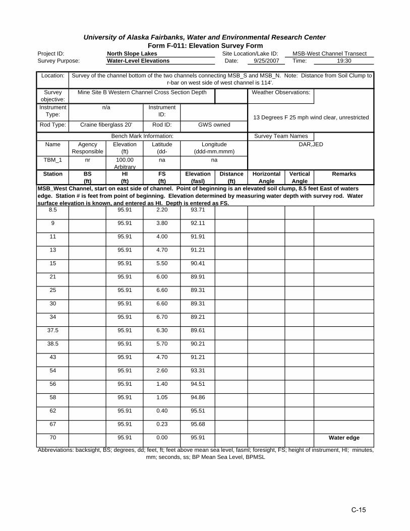
North Slope LakesSurvey Purpose: Water-Level Elevations Date: 9/25/2007 Time: 19:30
Location:
Survey objective:Instrument
Type:Instrument
ID:
Rod Type: Rod ID:
Name Agency Responsible
Elevation(ft)
Latitude(dd-
TBM_1 nr 100.00Arbitrary
na
Station BS(ft)
HI(ft)
FS(ft)
Elevation(fasl)
Distance(ft)
Horizontal Angle
Vertical Angle
Remarks
8.5 95.91 2.20 93.71
9 95.91 3.80 92.11
11 95.91 4.00 91.91
13 95.91 4.70 91.21
15 95.91 5.50 90.41
21 95.91 6.00 89.91
25 95.91 6.60 89.31
30 95.91 6.60 89.31
34 95.91 6.70 89.21
37.5 95.91 6.30 89.61
38.5 95.91 5.70 90.21
43 95.91 4.70 91.21
54 95.91 2.60 93.31
56 95.91 1.40 94.51
58 95.91 1.05 94.86
62 95.91 0.40 95.51
67 95.91 0.23 95.68
70 95.91 0.00 95.91 Water edge
Longitude(ddd-mm.mmm)
DAR,JED
na
Abbreviations: backsight, BS; degrees, dd; feet, ft; feet above mean sea level, fasml; foresight, FS; height of instrument, HI; minutes, mm; seconds, ss; BP Mean Sea Level, BPMSL
MSB_West Channel, start on east side of channel. Point of beginning is an elevated soil clump, 8.5 feet East of waters edge. Station # is feet from point of beginning. Elevation determined by measuring water depth with survey rod. Water surface elevation is known, and entered as HI. Depth is entered as FS.
Craine fiberglass 20' GWS owned
Bench Mark Information: Survey Team Names
Survey of the channel bottom of the two channels connecting MSB_S and MSB_N. Note: Distance from Soil Clump to r-bar on west side of west channel is 114'.
Mine Site B Western Channel Cross Section Depth Weather Observations:
n/a
13 Degrees F 25 mph wind clear, unrestricted
University of Alaska Fairbanks, Water and Environmental Research CenterForm F-011: Elevation Survey Form
Project ID: Site Location/Lake ID: MSB-West Channel Transect
C-15
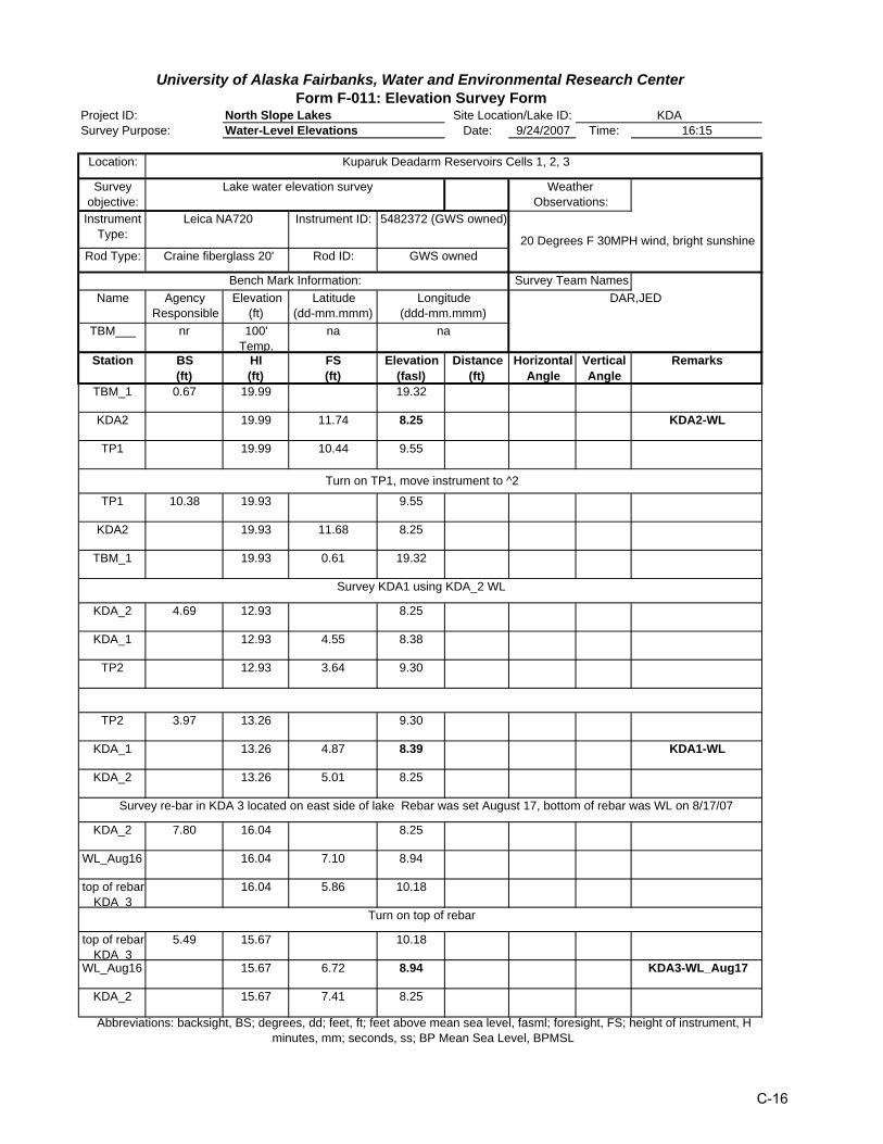
North Slope LakesSurvey Purpose: Water-Level Elevations Date: 9/24/2007 Time: 16:15
Location:
Survey objective:
InstrumentType:
Instrument ID:
Rod Type: Rod ID:
Name Agency Responsible
Elevation(ft)
Latitude(dd-mm.mmm)
TBM___ nr 100'Temp.
na
Station BS(ft)
HI(ft)
FS(ft)
Elevation(fasl)
Distance(ft)
Horizontal Angle
Vertical Angle
Remarks
TBM_1 0.67 19.99 19.32
KDA2 19.99 11.74 8.25 KDA2-WL
TP1 19.99 10.44 9.55
TP1 10.38 19.93 9.55
KDA2 19.93 11.68 8.25
TBM_1 19.93 0.61 19.32
KDA_2 4.69 12.93 8.25
KDA_1 12.93 4.55 8.38
TP2 12.93 3.64 9.30
TP2 3.97 13.26 9.30
KDA_1 13.26 4.87 8.39 KDA1-WL
KDA_2 13.26 5.01 8.25
KDA_2 7.80 16.04 8.25
WL_Aug16 16.04 7.10 8.94
top of rebar KDA 3
16.04 5.86 10.18
top of rebar KDA 3
5.49 15.67 10.18
WL_Aug16 15.67 6.72 8.94 KDA3-WL_Aug17
KDA_2 15.67 7.41 8.25
Kuparuk Deadarm Reservoirs Cells 1, 2, 3
Craine fiberglass 20'
University of Alaska Fairbanks, Water and Environmental Research CenterForm F-011: Elevation Survey Form
Project ID: Site Location/Lake ID: KDA
Abbreviations: backsight, BS; degrees, dd; feet, ft; feet above mean sea level, fasml; foresight, FS; height of instrument, Hminutes, mm; seconds, ss; BP Mean Sea Level, BPMSL
Longitude(ddd-mm.mmm)
Survey Team NamesDAR,JED
Bench Mark Information:
na
Turn on top of rebar
Survey re-bar in KDA 3 located on east side of lake Rebar was set August 17, bottom of rebar was WL on 8/17/07
GWS owned
Survey KDA1 using KDA_2 WL
Turn on TP1, move instrument to ^2
Weather Observations:
20 Degrees F 30MPH wind, bright sunshine
Leica NA720
Lake water elevation survey
5482372 (GWS owned)
C-16