LaGrange Bank Parcel Development Package Quality/Surface Water Protection/401... · LaGrange Bank...
25
LaGrange Bank Parcel Development Package (DRAFT) GES Neuse River Basin Umbrella Mitigation Bank – DWQ#: 08‐0511v2 Greene Environmental Services, LLC 5/29/2012 2012
Transcript of LaGrange Bank Parcel Development Package Quality/Surface Water Protection/401... · LaGrange Bank...
LaGrange Bank Parcel Development Package (DRAFT)
GES Neuse River Basin Umbrella Mitigation
Bank – DWQ#: 08‐0511v2
Greene Environmental Services, LLC
5/29/2012
2012
Table of Contents 1.0 Project Location and Description...................................................................................................... 3
2.0 Project Area – Existing Conditions .................................................................................................... 3
2.1 Geologic & Soil Characteristics ..................................................................................................... 3
2.2 Vegetative Communities............................................................................................................... 5
2.3 Threatened and Endangered Species ........................................................................................... 5
2.4 Environmental Issues .................................................................................................................... 6
2.5 FEMA Floodplain/Floodway Mapping........................................................................................... 6
3.0 Proposed Nutrient Offset and Riparian Buffer Restoration Plan...................................................... 7
4.0 Monitoring and Maintenance Plan ...................................................................................................8
5.0 Financial Assurance Language .......................................................................................................... 9
6.0 Nutrient Offset and Riparian Buffer Mitigation Potential ................................................................ 9
7.0 References ......................................................................................................................................10
Appendix A: Figures
Figure 1: Vicinity Map
Figure 2: USGS Topographic Map – La Grange
Figure 3: Aerial Map Proposed Nutrient Offset Buffer Area
Figure 4: Lenoir County Soil Survey Map
Figure 5: Proposed Nutrient Offset Buffer Area (Survey Excerpt)
Figure 6: FEMA Floodplain/Floodway Map
Appendix B:
Conservation Easement
DWQ Stream Determination Letter
Greene Environmental Services, LLC Page 2

1.0 Project Location and Description
Greene Environmental Services, LLC (GES) of Snow Hill, North Carolina proposes to add the La
Grange site to the Greene Environmental Services Neuse River Basin Riparian Buffer and
Nutrient Offset Umbrella Bank. The La Grange site (bank parcel) is located at the southwest
intersection of NC 903 and Old Jason Road (SR 1501), north of La Grange, in Lenoir County,
North Carolina (Figure 1). The latitude/longitude coordinates of the site are approximately
35.34202°N and ‐77.79001°W. The purpose of the proposed mitigation bank is to improve
water quality within the Neuse River Basin by reducing nutrient and sediment inputs to the
watershed and providing off‐site mitigation for development requiring nutrient offsets.
The proposed bank parcel is located within the Middle Neuse Watershed (HUC: 03020202).
Stormwater runoff from this site drains into Meeting House Branch (Stream Index # 27‐72‐3),
which drains into Bear Creek (Stream Index # 27‐72‐(0.1)), a major tributary to the Neuse River.
According to the NC Division of Water Quality Basinwide Information Management System,
Meeting House Branch is classified as C; Sw, NSW. Mr. Chris Pullinger determined that the
stream as intermittent and subject to the Neuse Buffer Rule on April 4, 2011 (see Appendix B).
The bank parcel is 3.39 acres, including 0.87 acres of Neuse riparian buffer and 2.52 acres of
nutrient offset buffer restoration. This bank parcel shall be established under the terms and
conditions of the Greene Environmental Services Neuse River Basin Riparian Buffer and
Nutrient Offset Umbrella Bank made and entered into by Mr. Bobby Ham of Greene
Environmental Services, LLC, acting as the Bank Sponsor and the North Carolina Department of
Environment and Natural Resources – Division of Water Quality which was signed by the
Division Director on October 3, 2008.
The bank parcel was previous agricultural cropland and was planted with character species
during March of 2010. During the planting process, DWQ staff visited the site and determined
that it was suitable for nutrient offset mitigation.
2.0 Project Area – Existing Conditions
2.1 Geologic & Soil Characteristics Based upon review of the United States Geological Survey (USGS) La Grange, North
Carolina Quadrangle, the proposed Bank Parcel is located near the headwaters of
Greene Environmental Services, LLC Page 3
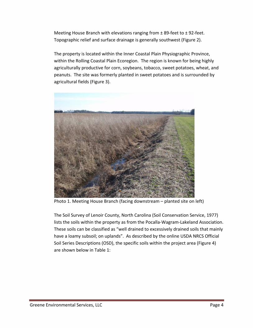
Meeting House Branch with elevations ranging from ± 89‐feet to ± 92‐feet.
Topographic relief and surface drainage is generally southwest (Figure 2).
The property is located within the Inner Coastal Plain Physiographic Province,
within the Rolling Coastal Plain Ecoregion. The region is known for being highly
agriculturally productive for corn, soybeans, tobacco, sweet potatoes, wheat, and
peanuts. The site was formerly planted in sweet potatoes and is surrounded by
agricultural fields (Figure 3).
Photo 1. Meeting House Branch (facing downstream – planted site on left)
The Soil Survey of Lenoir County, North Carolina (Soil Conservation Service, 1977)
lists the soils within the property as from the Pocalla‐Wagram‐Lakeland Association.
These soils can be classified as “well drained to excessively drained soils that mainly
have a loamy subsoil; on uplands”. As described by the online USDA NRCS Official
Soil Series Descriptions (OSD), the specific soils within the project area (Figure 4)
are shown below in Table 1:
Greene Environmental Services, LLC Page 4

Table 1. Mapped Soils within the La Grange Bank Parcel
Soil Type Acronym General Description
Craven Cr – fine sandy loam, 1 to 4% slopes Located on gently sloping sides of divides. Infiltration is moderately slow, and runoff is slow to medium. Moderate shrink‐swell potential, slow permeability, and runoff are the main limitations in the use and management of this soil.
Goldsboro Go – loamy sand, 0 to 2% slopes Located near shallow drainageways on broad, smooth divides. Infiltration is moderate and runoff is slow. A seasonal high water table is the main limitation in the use and management of this soil.
Pantego Pe – loam Located on broad, smooth flats in interstream areas, with slopes of < 1%. Infiltration is moderate and runoff is ponded to very slow. Water ponding on the surface and a seasonal high water table are the main limitations in the uses and management of this soil.
Rains Ra – sandy loam Located in depressions and on smooth flats in broad interstream areas, with slopes of < 1%. Infiltration is moderate and runoff is slow or the surface is ponded. Water ponding on the surface and a seasonal high water table are the main limitations in the uses and management of this soil.
2.2 Vegetative Communities The closest vegetative community is located downstream of the site along Meeting
House Branch. This forested area is an early succession, consisting primarily of typical
sweetgum (Liquidambar styraciflua) and red maple (Acer rubrum) that are
approximately 20‐40 years in age. The majority of the watershed draining to the site
consists of agricultural fields that are lacking in riparian/ditch buffers. The adjacent land
use consists entirely of agricultural fields, which primarily produce sweet potatoes, corn,
and soybeans.
2.3 Threatened and Endangered Species The US Fish and Wildlife Service (USFWS) and NC Natural Heritage Program (NHP)
databases were searched for federally listed threatened and endangered plant and
animal species for Lenoir County, NC. Two federally listed species, the red‐cockaded
woodpecker (Picoides borealis) and sensitive joint‐vetch (Aeschynomene virginica), are
currently listed in Wayne County (Table 2).
Greene Environmental Services, LLC Page 5

Table 2. Listed Threatened and Endangered Species in Wayne County, NC
Species Federal Status Habitat
Red‐cockaded woodpecker Endangered The red‐cockaded woodpecker prefers mature stands of longleaf pine (Pinus palustris) trees, generally over 80 years old. Habitat requirements average 125 to 200 acres in area. Although some cavities have been found in pine forests as small as 60 acres.
Sensitive joint‐vetch Threatened The joint‐vetch occurs in fresh to slightly brackish tidal river systems, within the intertidal zone where populations are flooded twice daily. It typically occurs at the outer fringe of marshes or shores; its presence in marsh interiors may be a result of nutrient deficiencies, ice scouring, or muskrat herbivory. The sensitive joint‐vetch is found in localities where plant diversity is high and annual species are prevalent.
A review of the North Carolina Natural Heritage Program (NCNHP) database shows no
occurrences of either species within a 2‐mile radius of the site. According to the NCNHP
Virtual Workroom, only one state listed species, Coachwhip (Masticophis flagellum), is
located within a 2‐mile radius of the site. This snake species is labeled as “SR”
(significantly rare) and resides in dry and sandy woods, primarily in pine/oak sandhills.
This site will provide no potential habitat for this species since the water table is fairly
high in this area and the site soils are not “dry and sandy”.
2.4 Environmental Issues Preliminary data was obtained from Environmental Data Resources, Inc. (EDR)
regarding the potential for on‐site or nearby sources of contamination. EDR
maintains an updated database of current and historical sources of contamination.
All storage tanks, whether above‐ground or underground are identified, as well as
superfund sites, landfills, hazardous waste sites, and other potential hazards. No
sites were noted on their database within a one‐mile radius of the Bank site.
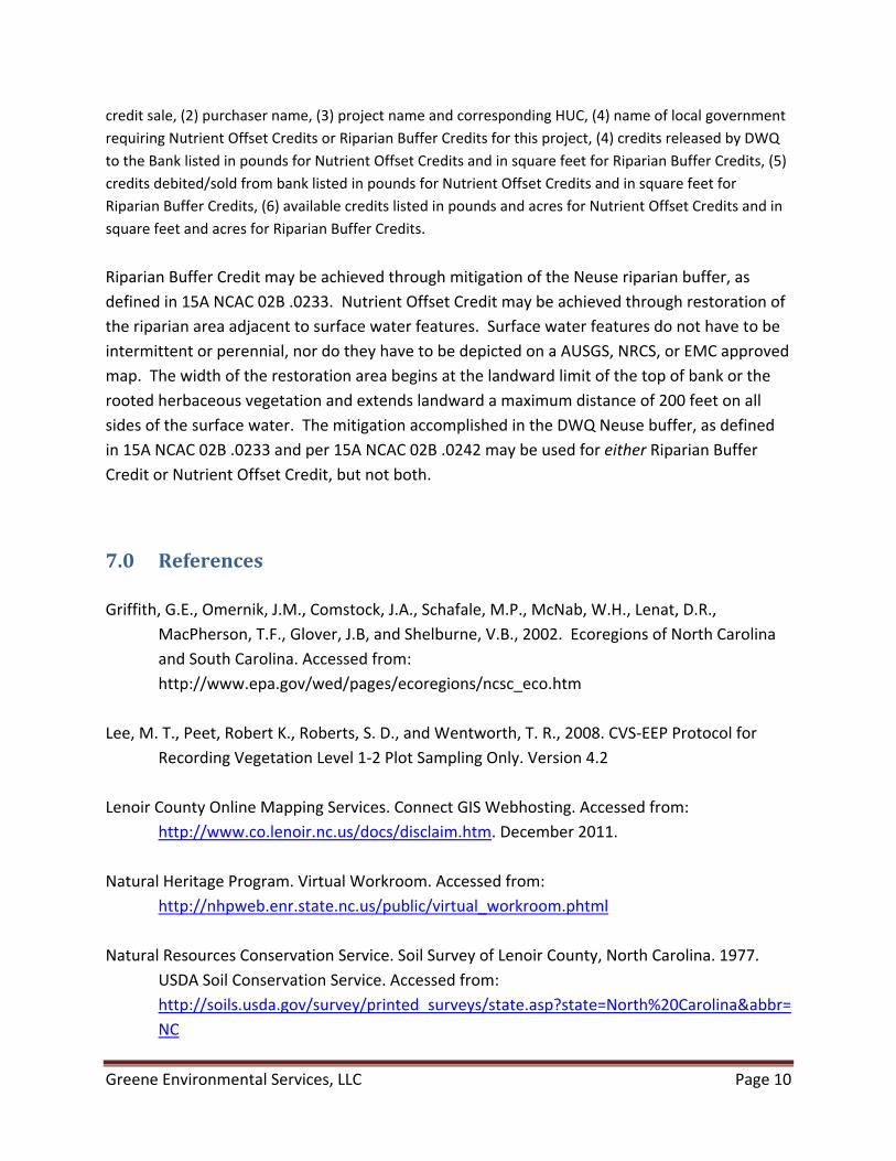
2.5 FEMA Floodplain/Floodway Mapping Meeting House Branch and its immediate floodplain are not located within the
Federal Emergency Management Association’s (FEMA’s) designated floodway and
Greene Environmental Services, LLC Page 6

approximate 100‐year flood boundary (Figure 6). Therefore, no floodplain impacts
are anticipated.
3.0 Proposed Nutrient Offset and Riparian Buffer Restoration Plan
Actions required to develop the La Grange site for mitigation were begun in March of 2010 and
supplemental plantings occurred during the winter of 2011. The entire conservation easement
area is 200 feet in width along Meeting House Branch. The area was tilled using standard
farming equipment prior to planting in order to aid plant growth and nutrient uptake. Planting
of the former sweet potato field with character tree species (Table 3) occurred within the
proposed conservation easement area (Figure 5). “Character Trees” are defined as planted or
volunteer species identified from a survey of local vegetation on less degraded sections of the
specified stream and from reference literature that details native species.
The trees were purchased from Claridge Nursery (NC DFR) in Goldsboro. Mowing and other
vegetation management practices may be implemented during the initial years of tree
establishment on the site to prevent the establishment of invasive species that will attempt to
out‐compete the planted native vegetation. In an effort to control grazing by rabbits and other small
herbivores, two raptor perches (17 ft tall wooden posts with horizontal perch bars) will be installed on
the tract.
In the summer of 2011, mowing of portions of the site occurred to limit dog fennel
(Eupatorium capillifolium) and silverling (Baccharis glomeruliflora) growth. The following table
lists the character tree species and quantities that were planted in 2011. All tree species are
bare root seedlings.
Table 3. Character Trees Planted in 2010 and 2011.
Scientific Name Common Name Total Number Planted
Betula nigra River birch 400 Fraxinus pennsylvanica Green ash 200 Nyssa sylvatica Blackgum 200 Quercus pagoda Cherrybark oak 200 Taxodium distichum Bald cypress 400 Total Seedlings Planted 1400 Seedlings Planted per Acre 413
Alternative trees for supplemental planting may include: Persimmon (Diospyros virginiana),
green ash (Fraxinus pennsylvanica), sycamore (Platanus occidentalis), white oak (Quercus alba),
turkey oak (Quercus laevis), longleaf pine (Pinus palustris), tulip poplar (Liriodendron tulipifera)
Greene Environmental Services, LLC Page 7

and live oak (Quercus virginiana). These trees will be bare root seedlings or containerized
plants. Tree species that are best adapted to better drained site conditions (Quercus virginiana,
Quercus laevis, Quercus alba, Pinus palustris and Diospyros virginiana) will be planted on
portions of the tract shown as Craven fine sandy loam on the soil survey map. At the request of
DWQ staff, 100 wax myrtle (Morella cerifera), will be planted on the site to assist in the
establishment of a shrub layer.
Buffer vegetative success criteria are based upon the density and growth of character tree
species as defined in Table 3. As per the Greene Environmental Services Neuse River Basin
Riparian Buffer and Nutrient Offset Umbrella Banking Instrument, vegetative success criteria
will be based upon guidelines set forth in the Guidelines for Riparian Buffer Restoration
prepared by the North Carolina Ecosystem Enhancement Program (or subsequent updated
versions of these guidelines in place at the date of acceptance of a BPDP), and shall be defined
as a success rate equivalent to 320 live stems per acre at the end of the 5‐year monitoring
period. For the purposes of monitoring, planted species must account for a minimum of 30
percent of the tree density in the monitoring plots.
If vegetative success criteria are not achieved based on acreage density calculations from
combined monitoring plots over the entire restoration area, or if an inspection of the
restoration/mitigation site indicates that portions of the site do not have sufficient stem
densities or are otherwise deficient, supplemental planting shall be performed with tree species
approved by NCDWQ. Supplemental planting shall be performed as needed until vegetative
success criteria are met. No quantitative measurements of herb assemblages will be required to
meet the vegetative success criteria. The quantity of monitoring plots shall be determined in
accordance with The Carolina Vegetative Sampling Protocol (Levels I & II).
4.0 Monitoring and Maintenance Plan
The La Grange Bank Site will be monitored annually for five years (or until DWQ’s success
criteria have been met). Monitoring activities have already begun on the site since the initial
planting. Supplemental planting and necessary site modifications will continue to be implanted
as necessary. Monitoring activities will follow the terms and conditions of the Greene
Environmental Services Neuse River Basin Riparian Buffer and Nutrient Offset Umbrella Banking
Instrument, signed by the Division Director and Mr. Bobby Ham (GES).
Vegetative success will be monitored within the restored Neuse riparian buffer and a
monitoring report will be provided to DWQ no later than December 31st of each monitoring
year. The report will include vegetative plot data, monitored in accordance with the CVS‐EEP
Greene Environmental Services, LLC Page 8

Protocol for Recording Vegetation (CVS‐EEP, v. 4.2). Plots measuring 100 m2 (ten by ten meter
squares) will be permanently established. The La Grange Bank Parcel will contain 2 vegetative
monitoring plots, exceeding the requirement of 2% of the proposed restoration area. Since the
site is a small one, two vegetative plots are considered prudent to get a realistic picture of the
site’s success. The plant species, survival rates, and character species density will be recorded
within each plot, as well as general notes on problems encountered or unique situational
developments. Photographs of each plot from the same plot corner will be included in the
monitoring reports to provide DWQ with a snapshot of the site success each year. At the end of
the five year monitoring period, target acreage density for the Neuse riparian buffer and
nutrient offset area is a minimum of 320 character trees per acre. Monitoring will take place
between August and November.
5.0 Financial Assurance Language
Greene Environmental Services, LLC will provide a performance bond or Letter of Credit to
ensure completion of all mitigation work. The amount of the performance bond or Letter of
Credit shall be efficient to cover all costs associated with establishing the site for its proposed
mitigation. Upon approval of the subject BPDP, Greene Environmental Services, LLC will
provide financial assurance in the form of a monitoring bond or letter of credit in the amount of
at least $100,000 to ensure that adequate funds are available for completion of the
maintenance and monitoring outlined in the BPDP under Section 3.
6.0 Nutrient Offset and Riparian Buffer Mitigation Potential
The La Grange Bank Parcel consists of 3.39 acres, protected under a permanent conservation
easement. The Parcel will generate 37,939.70 square feet (0.87 acres) of Neuse riparian buffer
credit and 109,581.98 square feet (2.52 acres) of nutrient offset buffer which yields 5,728.01
(lb‐N) Nitrogen credits at 2,273.02 lb‐N/acre. Greene Environmental Services, LLC will maintain
one credit ledger for Neuse riparian buffer credits which are generated from 0 to 50 feet from
the top of bank of Meeting House Branch and one ledger for nutrient offset credits which are
generated from 51‐200 feet out from the Neuse buffer of the intermittent stream. Each credit
ledger shall be submitted on a separate 8 ½ in X 11 in spreadsheet with legible font style and
font size. At a minimum and unless otherwise requested by DWQ, credit ledgers shall contain
the following information: Bank Details listed in a header: (1) name of the approved banking
instrument as it appears on the instrument document, (2) sponsor name, (3) bank parcel name as it
appears on the BPDP, (4) DWQ project number for the BPDP, (5) date the ledger was last updated, 6)
total credits released to date. Credit Details Table with the following for each credit sale: (1) date of
Greene Environmental Services, LLC Page 9
credit sale, (2) purchaser name, (3) project name and corresponding HUC, (4) name of local government
requiring Nutrient Offset Credits or Riparian Buffer Credits for this project, (4) credits released by DWQ
to the Bank listed in pounds for Nutrient Offset Credits and in square feet for Riparian Buffer Credits, (5)
credits debited/sold from bank listed in pounds for Nutrient Offset Credits and in square feet for
Riparian Buffer Credits, (6) available credits listed in pounds and acres for Nutrient Offset Credits and in
square feet and acres for Riparian Buffer Credits.
Riparian Buffer Credit may be achieved through mitigation of the Neuse riparian buffer, as
defined in 15A NCAC 02B .0233. Nutrient Offset Credit may be achieved through restoration of
the riparian area adjacent to surface water features. Surface water features do not have to be
intermittent or perennial, nor do they have to be depicted on a AUSGS, NRCS, or EMC approved
map. The width of the restoration area begins at the landward limit of the top of bank or the
rooted herbaceous vegetation and extends landward a maximum distance of 200 feet on all
sides of the surface water. The mitigation accomplished in the DWQ Neuse buffer, as defined
in 15A NCAC 02B .0233 and per 15A NCAC 02B .0242 may be used for either Riparian Buffer
Credit or Nutrient Offset Credit, but not both.
7.0 References
Griffith, G.E., Omernik, J.M., Comstock, J.A., Schafale, M.P., McNab, W.H., Lenat, D.R.,
MacPherson, T.F., Glover, J.B, and Shelburne, V.B., 2002. Ecoregions of North Carolina
and South Carolina. Accessed from:
http://www.epa.gov/wed/pages/ecoregions/ncsc_eco.htm
Lee, M. T., Peet, Robert K., Roberts, S. D., and Wentworth, T. R., 2008. CVS‐EEP Protocol for
Recording Vegetation Level 1‐2 Plot Sampling Only. Version 4.2
Lenoir County Online Mapping Services. Connect GIS Webhosting. Accessed from:
http://www.co.lenoir.nc.us/docs/disclaim.htm. December 2011.
Natural Heritage Program. Virtual Workroom. Accessed from:
http://nhpweb.enr.state.nc.us/public/virtual_workroom.phtml
Natural Resources Conservation Service. Soil Survey of Lenoir County, North Carolina. 1977.
USDA Soil Conservation Service. Accessed from:
http://soils.usda.gov/survey/printed_surveys/state.asp?state=North%20Carolina&abbr=
NC
Greene Environmental Services, LLC Page 10

North Carolina Ecosystem Enhancement Program (NCEEP) 2004. Guidelines for Riparian Buffer
Restoration. Accessed from:
http://portal.ncdenr.org/web/wq/swp/ws/401/riparianbuffers
United States Fish and Wildlife Service. Threatened and Endangered Species by County
Accessed from:
http://ecos.fws.gov/speciesProfile/profile/speciesProfile.action?spcode=Q24J and
http://ecos.fws.gov/tess_public/countySearch!speciesByCountyReport.action?fips=3710
7
USGS. The National Map Viewer. Accessed from: http://viewer.nationalmap.gov/viewer/
January 2012.
Greene Environmental Services, LLC Page 11

APPENDIX A
Figures
Greene Environmental Services, LLC

3.5 mi
La Grange
Site
Figure 1 –
Vicinity Map

Bank Parcel
Location
Figure 2 – USGS Topographic Map
N.T.S

La Grange Bank
Parcel
Conservation
Easement
Boundary
Figure 3 – Aerial Map

Figure 4 –
Soils Map
LEGENDCr: Craven fine sandy loam Go: Goldsboro loamy sand
Pe:
Pantego loam Ra: Rains sandy loam N.T.S.
Bank
Parcel

Figure 5 – Survey Excerpt
Neuse Buffer Area: 37,939.70 sq. ft. (0.87 acres)
Nutrient Offset Area: 109,581.98 sq. ft. (2.52 acres)
N.T.S.
Nutrient Offset Area
Neuse Buffer Area
Figure 6 –
FEMA Floodplain/Floodway Mapping
N.T.S.
Bank
Parcel
Greene Environmental Services, LLC
APPENDIX B
Conservation Easement DWQ Stream Determination Letter


Bever y Eaves PefdueGovemof
&NCDENR
North Carolina Department of Environment and Natural ResourcesD vis on of Water Quali ly
Coleef l- l SulinsDireclof
March 25.2010
Dee FreemafSecfelary
DWQ#:08-051lv2Lenoir County
Mr. Bobby HamGreene Environmental Services, LLC90 Ham Produce RoadSnow Hi l l , NC 28580
401 OveBrghrExpress Review Pem tling Un/t1650 fvlailServlce Center, Raleigh Notrh Carclrna 27699-1650tocalion 232l Aabtee Blvd , Ra/ergh Nodh Carolrna 27604Phone 919-733-1786 \ FAX 919 733 6893iftemetr htlp //h2o enrstate nc ustncwetlafds/
r' Equa Cppo.iun ty Affrrnzlr?e Aclron Employer
shad ing/cross-hatchinc showinq areas orooosed for buffer and./or nutrientoffset credit.
- j. DiSft"conservation easement
-' k. Draft financial assurance document
As per the UMBI signed by the DWQ Director on October 3, 2008, the initial release (20%) of creditswould occur following approval ofthe BPDP, recording ofthe conservation easement and purchase ofanerfbrmance bond.
Re: LaGrange Site - NC 903 near Old Jason RoadMeeting House Branc}r [27-72-3, C: Sw. NSW]
Or March 25,2010, Eric Kulz and Lia Gilleski of the Division of Water Quality (DWQ) met DavidKnowles (representing Greene EnviroDmental Services, l-LC) at the above referenced site to assess thefeasibilib, of the site as a nutrient off'set mitigation sit for inclusion into the CES Umbrella Bank. Someplanting has been completed to date, however the extent of the final planting area has yet to bedetennined.
Based on our observations the site appears suitable for use as a nutrient offset mitigation site. In order toinclude this site in your existing umbrella bank, GES must submit for approval a bank parcel developmentpackage (BPDP). The BPDP should include:
a. Site location (county, coordinates, 8-digit HUC), size. other general info,
^ _- .1 --- b- Water conveyance features on site. For streams, a DWQ stream determination
, r .L - _I
oJ!.rr'bty must be included except for large obvious stream-/river features. All ditchesz :rc' should be shown as well.
c. Proposed planting areas and Iimits ofconservation easement.d. Grading plan (if needed)e. Proposed species. species, numbers and densities.I. NU calculatron tactors.g. Amount of buffer and/or NO credit to be generated.h. Service area (8-digit HUC in which site is located). ^-------_:- , ,.i. Craphics, including USGS map; USDA soil map (paper copy); graphics
clearly showing site boundaries, conveyances. easement boundaries, and

Greene Environmental Services, LLCPage 2 of2
March 25,2010
During the site visit, DWQ observed that heavy equipment had b€en driven through some areas that hadalready been planted in order to maintain site ditches. Should GES elect to proceed with addition of thissite to the Umbrella Bank, dre landowner must understand that these areas are to be undisturbed forest andheavy equipment will no longer be allowed within the conservation easement for any reason. Anyadditional ditch maintenance should be conducted from areas outside the easement and anv disturbance toplanted materials within the easement must be avoided.
Please feel fiee to contacl Lia Myott Gilleski at (919) 733-9502 if you have any questions regarding thisletter.
Sincerely,
Ian McMillan, Acting Supervisor40l/Express Review Oversight Unit
lJWImg
c.: File copyAl Hodge, DWQ WaROJeff Becker, 1004 Glencastle Way, Raleigh, NC 27606
North Carolina
Beverly Eaves PerdueGovernor
Department of Environment and NaturalDivision of Water Quality
Coleen H, SullinsDirector
Resources
Dee FreemanSecretary
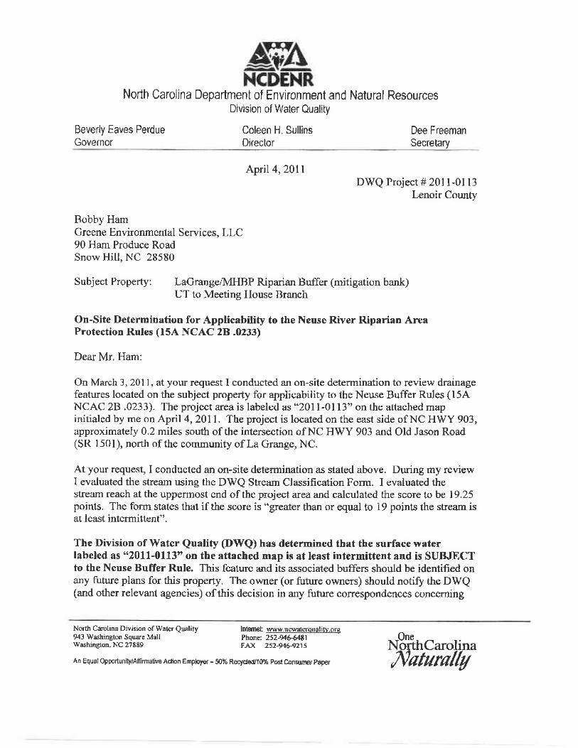
Apil 4,2DlrDWQ Project # 201 l-01 13
Lenoir County
Bobby HamGreene Environmental Services. LLC90 Ham Produce RoadSnow Hill, NC 28580
Subject Property: LaGrange.MHBP Riparian Buffer (mitigation bank)UT to Meeting House Branch
On-Site Determination for Applicability to the Neuse River Riparian AreaProtection Rules (l5A NCAC 2B .0233)
Dear Mr. Ham:
On March 3, 201 l, at your request I conducted an on-site determination to review drainagefeatures located on the subject property for applicability to the Neuse Buffer Rules (15ANCAC 28 .0233). The project area is labeledas"2011-0113"onthe attached mapinitialed by me on April 4,2011. The project is located on the east side of NC HWY 903,approximately 0.2 miles south of the intenection of NC HWY 903 and Old Jason Road(SR l50l), north of the community of La Grange, NC.
At your request, I conducted an on-site detennination as stated above. During my reviewI evaluated the stream using the DWQ Stream Classification Form. I evaluated thestream reach at the uppermost end of the project area and calculated the score to be 19.25points. The form states thal if the score is "greater than or equal to 19 points the sheam isat least intermittent".
The Division of Water Quality @rtrQ) has determined that the surface waterlabefed as "2011-0113" on the attached map is at least intermittent and is SUBJECTto the Neuse Buffer Rule. This feature and its associated buffers should be identified onany future plans for this property, The owner (or future owners) should notifu the DWQ(and other relevant agencies) ofthis decision in any future correspondences conceming
An Equal Oppo.tunity/Afinnative Adion Employer - 5n% Rectdedlo% pod Con$mer paper
NSthCarolina,Natura//y
Norlh Carol ina Division of Water Quality943 Washinglon Square Mallwashin8ton, NC 27889
IntSmet w$w.nc$.aterou al ifv,otePhonf: 25244544E1FAX 252946rt2t5

l )age 2 ol '2
this property. This on-site determination shall expire live (5) years liom the datc of thisletter.
Landowners or affecred parties that dispute a determination made by the DWQ orDelegated Local Authority that a surface water exists and that it is subject to the bufferrule may request a determination by the Director. A request for a determination by theDirector shall be referred to the Director in writing c/o Cyndi Karol1,. DWQ.40lOve rsighttlixpress Revrew Permitting Unit, 2321 Crabtree Blvd., Suite 250, Ralcigh. NC27 604-2260. lndividuals that dispute a determination by the DWQ or Delegared LocalAuthority that "exempts" a surface water from the buffcr rule may ask for an adjudicatoryhearing. You musl act w'ithin 60 days of thc datc that you rcccivc this letler. Applicanr.sarc herebv notilied that the 60-day statutory appcal tinrc docs not start unlil rhc allcctcdparty (includinB dowrrsiream and adjacent lando.,vners) is nctilled cl'this Cecision. D\!.'Qrecommcnds that the applicant conduct this notilication in order to bc certain that thirdparty appeals are made in a timely nranner. To ask for a hearing. scnd a rvritten petition-which conforms to Chapter I 508 of the North Carolina Ceneral Statures to the Officc of'Adnrinistrative l{earings, 67l4 Mail Service Ccnter, Ralcigh, N.C. 27699-6714. l'hisdetermination is final and binding unless you ask for a hearing within 60 days.
This letter only addresses the applicabiliry to the buffer rules and docs nor approvc anyactivity within the buffers. Nor docs this letter approvc any activity u'ithin Watcrs of theUnircd States or Waters ofthc Statc. If you havc any additional qucstions or requireadditional information olease call me at Q52\ 948-3920.
Sincerely,
rn--- l*lo--f.Chris Pul l ingerDivision ol' Water QualitySurface Water ProteclionWashington Rcgional Ollice
Enclosures: copy of l:24,000 scalc USGS topographic map, La Grange quadrangle
cc; DWQ 401 OversighVExpress Unit - Atln: Lia Cilleski
)VaRO File Copyr/David Knos les; 2813 Jefferson Dr.; Greenville. NC 27858
I i )enamc 201I-01 l3

Cem
/-
. .Lel
Slradeio1114-- /ffiNortr Csotrm Envirarunental
llrrfng* OommbaionDlvticr Of $/aar OtnrfiY I
tJt r ' tahq^\ 9
ao\\ -o\\j