
Lagos Summer School 2006 - Nautical …nautarch.tamu.edu/shiplab/00-pdf/Castro 2006 - SLR12...The...
169
Texas A&M University - Department of Anthropology - Nautical Archaeology Program Lagos Summer School 2006 Filipe Castro, Tiago Fraga, Pearce Paul Creasman, Bryana Dubard, Alexis Catsambis, George Schwarz and Samuel Koepnick Ship Lab Report 12 November 2006
Transcript of Lagos Summer School 2006 - Nautical …nautarch.tamu.edu/shiplab/00-pdf/Castro 2006 - SLR12...The...

Texas A&M University - Department of Anthropology - Nautical Archaeology Program
Lagos
Summer School 2006
Filipe Castro, Tiago Fraga, Pearce Paul Creasman, Bryana Dubard, Alexis Catsambis, George Schwarz and Samuel Koepnick
Ship Lab Report 12
November 2006

1
Ship Lab Report 12
September 2006
Lagos Summer School 2006
Filipe Castro, Tiago Fraga, Pearce Paul Creasman, Bryana DuBard, Alexis Catsambis, George Schwarz and Samuel Koepnick.
College Station, October 30, 2006

2
ShipLab Report 12 Lagos Summer School 2006
Câmara Municipal de Lagos
Texas A&M University:
Nautical Archaeology Program
Center for Maritime Archaeology and Conservation
Institute of Nautical Archaeology
Acknowledgements The Nautical Archaeology Program team would like to thank the Municipality of Lagos, namely Mr. Júlio Barroso, the city’s Mayor, Dr. Rui Loureiro, director of the city’s Projecto Municipal Ciência e Descobrimentos, for their invitation and generous support of this summer school, and Mrs. Elena Morán, the city’s archaeologist, for her precious help. Dr. Peter Amaral, Texas A&M University Alumni and a long time friend of the Institute of Nautical Archaeology and the Nautical Archaeology Program, whose generous contribution made it possible for the students to travel to Portugal. RPM Nautical Foundation, whose generous contribution made possible the study of the important collection of stone anchors from Ponta da Piedade and other underwater sites.

3
INDEX
1. Introduction ………………………………………..…..…………. 4 2. Objectives ……………..………………………..……..…………. 8 3. Team ……………………………………………………..……….. 9 4. Lodging …………………………………………………..………..13 5. Logistics ………………………………………………..………….13 6. Outcomes ………………………………………………..………..16 7. Conclusions and Further Actions ……….……………..……….17 8. References ………………………………………………..………18 Appendixes:
Appendix 1 - Memorandum of Agreement …………………....20 Appendix 2 – Syllabus …………………………………………..26 Appendix 3 - Artifact Inventory and Recording ……………….33 Appendix 4 – Inquiry ……………………………………….…….92 Appendix 5 - Non-Intrusive Surveys ……………………..……125 Appendix 6 – Visits ………………………………………..…….146 Appendix 7 – Visit to Portimão’s Archaeological Museum …..156 Appendix 8 – Seminar ……………………………………….....160 Appendix 9 – Conferences ………………………………..……162

4
1. Introduction Algarve is the southernmost region of Portugal (Figure 01). Its name derives from al Gharb, the Arab designation of the western part of the al-Andaluz province. Algarve’s culture is both a result of its isolation – as it is physically separated from the rest of the country by a chain of mountains – and its diverse contacts with the seafaring peoples of the Mediterranean and the North of Europe during at least the last three millennia.
Figure 01 – Algarve, Portugal.
Its continuous contact with the Mediterranean made it part of that world, or at least part of a larger Mediterranean world, which encompasses the regions away from its shores where the Mediterranean culture still resonates with considerable intensity (Arruda 1999a, 21). Algarve’s archaeological record is rich, and it’s most important archaeological sites span a period of over five millennia (Morán 2001). Evidence for early seafaring activities is indirect, but it is clear that there were intense contacts between the inhabitants of its early settlements – near today’s Castro Marim, Tavira, Faro, Silves, Lagos and Aljezur – and the Mediterranean seafarers, such as the Phoenicians, Greeks, Tartessic, and Punic peoples, from at least the beginning of the 1st millennium BC (Arruda 1999a). We know almost nothing about the settlements of the first half of the 1st millennium BC, but around the middle of the millennium there are a few known cities in Algarve. Writing, the potter’s wheel, and iron technology arrived during the 7th century BC, undoubtedly brought by Phoenician visitors. The prevalent form of social organization in this area was almost certainly the city-state, and their stone houses were typically Mediterranean (Arruda 1999b). Classical authors refer to five pre-Roman cities from east to west: Baesuris, Balsa, Ossonoba, Portus Hannibalis and Lacobriga. After Lacobriga there was the Promotorium Sacrum (today’s Sagres) and the unknown sea. Archaeologists believe that Baesuris was situated under what is today the medieval castle of Castro Marim. Abundant Greek pottery dating to the 5th century BC, pottery from the north of Africa and Ibiza, as well as amphorae from Tartessus and Carthage, all attest to intense seafaring

5
activity in the region. The area that surrounds the hill on which the city stood is presently a plane but was accessible to large ships until the late 16th century (Arruda 1999b). The localization of Balsa is presently established beyond doubt near the modern city of Tavira. During the Roman domination it became one of the most important cities of Lusitânia. It decayed even before the Arab invasion of the 8th century AD and disappeared until the mid-19th century. Although the centers of the Tartessic and Phoenician settlement, the Turdetan settlement, and the Roman city are all located at different sites, they have in common a proximity to either the sea or the mouth of a river (Silva 2005). Ossonoba is located under the city of Faro. As with other Mediterranean cities, the Roman forum has been located beneath the main church square. Its inhabitants were considered Turdetani – a local people – by the Roman invaders. Located on an island that is now connected to the continent, Ossonoba maintained an important status throughout the history of Algarve and is now the region’s administrative capital (Arruda 1999b). It is not known where exactly the city of Portus Hannibalis stood, although it is possible that it was located near today’s Portimão (Arruda 1999b). The Arade River, which runs through Portimão, was an important avenue of penetration into the copper rich regions of Algarve’s west, and it was on its margins that the city Cilpes was built – perhaps where today lays the city of Silves. Cilpes gained importance, coining currency during the Republican period (Arruda 1999b, Morán 2003). The archaeological importance of the Arade River is well-known, and over the years looters and dredges have exposed an important collection of artifacts and an impressive number of shipwrecks (Castro 2005). Another nearby city, Ipses, also coined currency during this period and is believed to be located under today’s Vila Velha do Alvor. The last of the five cities mentioned by the Classical authors bore a Celtic name: Lacobriga. Evidence suggests that it is located near today’s city of Lagos - first around the nearby village of Bensafrim and later at Monte Molião.
After the fall of the Roman Empire, the Byzantines conquered the east and south of the Iberian Peninsula and kept control of Ossonoba until AD 624. Subsequently the Algarve fell under Visigoth rule, remaining so from the reign of king Suintila (AD 621-631) to the death of king Wamba (AD 672-680). The diocese of Ossonoba included more or less the territory that forms Algarve today. However, during the second half of the 7th century Algarve experienced the chaos generated by a number of civil wars that shook the Iberian Peninsula (Fabião 1999).
In AD 711, supported by one of the Visigoth factions, Algarve was invaded by an Umayyad force under Tariq ibn Ziyad. Largely composed of Berber Muslims, the 12,000 man army led by Tariq did not encounter much resistance. The following year the governor of North Africa, Musa bin Nusair (640-716), sent a reinforcement of 18,000 men, and Tariq completed the conquest of the entire Iberian Peninsula between AD 714 and 716 (Catarino 1999a). Algarve remained under Arab domination until 1249. In Spain, the last city to fall to the Christian rulers was Granada which fell in 1492. Information about the first two centuries of the long Arab rule is scarce. Evidence suggests the existence of Christian and Muslim communities living together in peace and a functional organized society working the fields, fishing, trading, and paying taxes to the Umayyad caliph until AD 750.

6
The Umayyad princes, after the Abbasid dynasty, took over the empire in the East. Its most important cities were today’s Silves, Faro, Tavira and Loule (Catarino 1999b). During the 9th century the territory was attacked by the Vikings, which fought a naval battle in AD 966. Chroniclers reported that in that year a fleet of 28 Viking ships was sighted off the coast of Portugal. An Arab fleet was prepared and left Seville as soon as possible, engaging the “infidels” in the Arade River. Many Vikings are said to have been killed, and many of their vessels were sunk. The surviving enemies fled, leaving behind the Arab prisoners that had been taken during the raid (Coelho, 1989). In the late 11th century, Algarve was invaded by the Almoravid Berbers and less than a century after by another Berber tribe, the Almohads (Macias 1999). During the 12th century the Christian reconquista, started by Charlemagne with the conquest of Catalonia four centuries earlier, gained power with the spirit of the crusades, and the Algarve region was attacked several times. However, in spite of the political turmoil of the Berber fights and the increasing Christian harassment, Algarve seems to have thrived economically until the full conquest of the region, in 1249, by the army of king Afonso III (1247-1279) (Picard 1999). After the reconquista, Algarve populations endured a crisis that stemmed from the disruption of maritime commerce with Muslim-controlled Mediterranean harbors, followed by a short period of demographic and economic growth in the late 13th and early 14th centuries. Then the region suffered the Black Death of 1348-1351, the wars with Castile (1369-1371, 1372, 1373, and 1381-1382) and the Portuguese war of succession of 1383-1385. During the late 14th and early 15th centuries Algarve experienced an important phase of economic growth, and Lagos became a critically important city, tightly connected to the process of maritime expansion whose beginnings historians place in 1415, with the conquest of the north African city of Ceuta by King João I. The antiquity of Lagos is well established and its archaeological richness undisputed. Its maritime culture is widely known due to Prince Henry the Navigator’s residence in the 15th century. Lagos played an important role in the support of military incursions into the north of Africa led by King João I (1385-1433) between 1415 and 1433, and later by kings Duarte (1433-1438) and Afonso V (1438-1481). Prince Henry was the third son of King João I and after 1413, based himself in the western part of Algarve – Vila do Infante and Lagos – from where he launched the maritime expeditions that led to the colonization of Madeira, Azores, and Cape Verde archipelagos and the exploration of the western coast of Africa as far as present-day Sierra Leone. Henry’s seafaring venture eventually led to the discovery of the India Route, which connected Portugal to India and a portion of the South American continent. The city saw a period of impressive seafaring activity during the 15th and subsequent centuries, and some of the ships sailing to and from Lagos were lost in or around its bay (Figure 02).

7
Figure 02 – Lagos Bay.
Tiago Fraga, an Aggie and the underwater archaeologist responsible for the inventory and assessment of the underwater cultural heritage of Lagos, has amassed an impressive list of historic shipwrecks and is working on the underwater archaeological chart of the region. It was following his suggestion and an invitation extended by Dr. Rui Loureiro that the Nautical Archaeology Program / Department of Anthropology at Texas A&M University started what we believe will be a long-term cooperation with the municipality of Lagos, materialized in the Memorandum of Agreement signed in 2006 by Texas A&M University and the City of Lagos. This report refers to the first field season at Lagos, in June 2006, which entailed a multitude of varying activities and aimed especially at establishing personal relations between Nautical Archaeology Program students and the local community. To find shipwrecks in Lagos’ waters is the ultimate objective of this project. The prospects are good, mostly when we look at Tiago Fraga’s work of inquiry and archival research. We hope that this is a long term project and that we can find and excavate shipwrecks that will tell us new things about the rich history of seafaring of Portugal.

8
2. Objectives Lagos Summer School 2006 stemmed from a Memorandum of Agreement signed last March between the Municipality of Lagos and Texas A&M University (see Appendix 1 and Appendix 2). The objectives were previously established, intended to provide students with the following learning opportunities:
2.1. To participate in a number of different archaeological projects related to the ongoing inventory of the nautical cultural heritage of the Municipality of Lagos;
2.2. To travel in the region in order to make acquaintance, as much as possible, with the culture, landscape and language; and
2.3. To meet local people and Portuguese scholars and try to establish working relations that will hopefully provide future opportunities.
The first objective entailed three major tasks: 2.1.a. Inventory and recording of a number of artifacts; 2.1.b. Inquiry into the artifact’s proveniences and possible unknown shipwreck sites; 2.1.c. Non-intrusive survey of several underwater sites with archaeological potential.
The second objective entailed the realization of several trips in the Algarve region, when the weather conditions made it impossible to dive. The third objective was addressed through two major events:
2.3.a. An optional advanced seminar taught by Dr. Francisco Contente Domingues – Director of the Post-Graduation Studies in Portuguese Discoveries at the University of Lisbon and one of the best world scholars of History of the Portuguese Expansion – was offered on one of the student’s days off; and
2.3.b. A series of conferences delivered by the students was offered in the Municipal Library, aiming at the general public and with three expressed objectives: 2.3.b.1. To raise the general awareness to the importance of the local seafaring-
related cultural heritage; 2.3.b.2. To show the capacity and skills of Texas A&M University’s Nautical
Archaeology Program; and 2.3.b.3. To provide an opportunity for the students to present their research publicly
and train their public speaking techniques. The organization of some of the missions carried out was handled by each one of the students in order to train their leadership skills in several different situations. All these objectives were set in articulation with the municipality ongoing program of inventory, study, and preservation of the city’s underwater cultural heritage.

9
3. Team
Texas A&M University Team
Filipe Castro, Instructor and PI Dr. Filipe Castro received a Licenciatura in Civil Engineering from the Universidade Técnica de Lisboa in 1984, an M.B.A. from the Universidade Católica Portuguesa in 1994, and a Ph.D. in Anthropology from the Nautical Archaeology Program at Texas A&M University in 2001. He has conducted most of his research in Portugal. As a manager, he was part of the team who in 1997 created the Centro Nacional de Arqueologia Náutica e Subaquática, the Portuguese state agency for nautical archaeology. Since then he has directed or participated in the study of several shipwrecks, mostly from the period of European maritime expansion.
Tiago Fraga, Co-PI and City Archaeologist, Tiago Fraga studied history at the Universidade Lusiada de Lisboa, and is currently finishing is M.A. at Texas A&M University. Worked in the Center of Underwater and Nautical Archaeology from 1997 to 2000, for the Portuguese Institute of Archaeology in 2001 and is currently employed by the Municipality of Lagos. Has directed several archaeological projects and presented in several international conferences. Currently directs the Underwater Cultural Heritage Survey of Lagos.
10
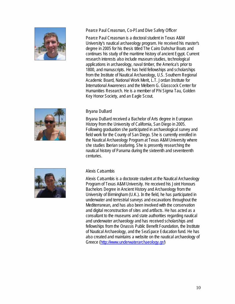
Pearce Paul Creasman, Co-PI and Dive Safety Officer Pearce Paul Creasman is a doctoral student in Texas A&M University's nautical archaeology program. He received his master's degree in 2005 for his thesis titled The Cairo Dahshur Boats and continues his study of the maritime history of ancient Egypt. Current research interests also include museum studies, technological applications in archaeology, naval timber, the America's prior to 1800, and manuscripts. He has held fellowships and scholarships from the Institute of Nautical Archaeology, U.S. Southern Regional Academic Board, National Work Merit, L.T. Jordan Institute for International Awareness and the Melbern G. Glasscock Center for Humanities Research. He is a member of Phi Sigma Tau, Golden Key Honor Society, and an Eagle Scout.
Bryana DuBard Bryana DuBard received a Bachelor of Arts degree in European History from the University of California, San Diego in 2005. Following graduation she participated in archaeological survey and field work for the County of San Diego. She is currently enrolled in the Nautical Archaeology Program at Texas A&M University where she studies Iberian seafaring. She is presently researching the nautical history of Panama during the sixteenth and seventeenth centuries.
Alexis Catsambis Alexis Catsambis is a doctorate student at the Nautical Archaeology Program of Texas A&M University. He received his Joint Honours Bachelors Degree in Ancient History and Archaeology from the University of Birmingham (U.K.). In the field, he has participated in underwater and terrestrial surveys and excavations throughout the Mediterranean, and has also been involved with the conservation and digital reconstruction of sites and artifacts. He has acted as a consultant to the museums and state authorities regarding nautical and underwater archaeology and has received scholarships and fellowships from the Onassis Public Benefit Foundation, the Institute of Nautical Archaeology, and the SeaSpace Education fund. He has also created and maintains a website on the nautical archaeology of Greece (http://www.underwaterarchaeology.gr/)

11
Samuel Koepnick Samuel Koepnick is an MA student at Texas A&M University. He received his Bachelor’s degree in Anthropology from the University of Nevada Reno in 2005. He has worked on various archaeological sites ranging from early American Indian to historic mining towns. With training in computer science and physics he has also worked on various open-source software projects including security and multimedia solutions. His interests include implementation of modeling in archaeological settings and the practical dissemination of information to the public. He is a recipient of the Sterling scholarship as well the Regent’s grant from Texas A&M University.
George Schwarz, Dive Master George Schwarz received his BA in Anthropology from the University of Cincinnati in 2003, and is currently working on his MA in Anthropology from the Nautical Archaeology Program at Texas A&M University. His undergraduate concentrations focused primarily on Mesoamerican archaeology and lithic technology. Present research for his Master's thesis involves medieval and post-medieval Iberian seafaring. Other academic interests include history of wooden shipbuilding technology, nautical manuscripts and treatises, and ethnographic studies involving contemporary wooden boat builders.
Luis de Jesus Luis de Jesus is in the senior year of the course Cultural Heritage Management in Universidade do Algarve, Portugal. In 2005 in attended the course of technicians and guides for underwater archaeology from Hipocausto. He as participated in several excavations underwater and from the Palaeolithic period in and out of the country. In 2006 become involved as a technician of underwater archaeology in the Lagos underwater cultural heritage survey under the guidance of Tiago Fraga.
João Marreiros João Marreiros is in the senior year of the course Cultural Heritage Management in Universidade do Algarve, Portugal. In 2005 in attended the course of technicians and guides for underwater archaeology from Hipocausto. He as participated in several excavations underwater and from the Palaeolithic period in and out of the country. In 2006 become involved as a technician of underwater archaeology in the Lagos underwater cultural heritage

12
survey under the guidance of Tiago Fraga.
Brett Ringsell Brett Ringsell is a Master Scuba Diver Trainer with over three thousand dives. He has worked in the Bahamas, Caribbean, South Florida and Brazil as a divemaster on board cruise ships before becoming a 2nd engineer aboard mega yachts. He returned to Portugal where he managed 2 dive centres before opening Osmosis Dive Centre in Lagos with his partner.

13
4. Lodging Students were lodged by the Municipality of Lagos at the excellent facilities of the Messe Militar.
5. Logistics Transports A car (and fuel) was rented (Texas A&M University) during the whole period of preparation and duration of the summer school. Several boats (and fuel) were provided by the Municipality of Lagos. Brett Ringsell (OSMOSIS) lent two of his boats and part of the diving equipment. Storing A storing space was provided by the Clube the Vela de Lagos, as well as occasional logistic support. Diving Students and instructor brought their own diving gear. Tanks, weights (OSMOSIS) and underwater recording equipment were provided by the Municipality of Lagos. Office Work The Municipality of Lagos provided a working room with telephone, internet, computers, printer, photocopier and drafting equipment for the students’ daily office work. The ShipLab (Texas A&M University) provided two laptop computers and three of the students brought their own computers. The Municipality of Lagos has a wireless internet space that was used for both work and leisure. Conferences The conferences were held in the City’s Public Library. Seminar The seminar taught by Dr. Francisco Contente Domingues was held in the City’s Public Library.

14
6. Outcomes The work developed by the Texas A&M University team during the month of June was part of a well-established program previously setup by the municipality through its Direcção de Projecto Municipal Ciência e Descobrimentos, and coordinated by Mr. Tiago Fraga, who is both a city employee and a masters student in the Nautical Archaeology Program at Texas A&M University. The outcomes of this year’s summer school can be evaluated according to the three objectives established beforehand and stated above:
6.1. To participate in a number of different archaeological projects related to the ongoing inventory of the nautical cultural heritage of the Municipality of Lagos;
6.2. To travel in the region in order to make acquaintance, as much as possible, with the culture, landscape and language; and
6.3. To meet local people and Portuguese scholars and try to establish working relations that will hopefully provide future opportunities.
6.1. Participation in archaeological projects This first objective entailed three major tasks:
6.1.a. Inventory and recording of a number of artifacts; 6.1.b. Inquiry into the artifact’s proveniences and possible unknown shipwreck sites; and 6.1.c. Non-intrusive survey of several underwater sites with archaeological potential.
It was organized as a project divided into independent missions. Diving was dependent of the weather and sea conditions, and missions were planed in a flexible manner, having in mind their importance, estimated total duration, means necessary to carry them out, dependence of weather conditions, and availability of local guides, supporting craft, and personnel. The following missions were carried out, from a wider list established beforehand and changed in view of the factors above stated.
6.1.a. Inventory and recording of artifacts (Appendix 3). 1) Anchor – Motel Âncora 2) Anchors – Fortress 3) Anchor – City Wall 4) Stone anchors and lead stocks at Museu de Portimão 5) Âncoras de Pedra – Atlantic Diving Albufeira
6.1.b. Inquiry: artifact’s proveniences and possible unknown shipwreck sites (Appendix 4)
1) Âncoras de Pedra – Atlantic Diving Albufeira 2) Lagos 2 shipwreck 3) Lagos 3 shipwreck

15
4) Ponta da Piedade 1 site 5) Pedra do Calvario site 6) Mr. Graca Mira artifact collection 7) Portimão stone anchors (Mr. Stephan Fend) 8) Boca do Rio shipwreck 9) Martinhal 1 shipwreck 10) Martinhal 2 shipwreck 11) Praia da Galé shipwreck
6.1.c. Non-intrusive survey of underwater sites with archaeological potential (Appendix 5).
1) Lagos 1 shipwreck 2) Lagos 4 shipwreck 3) Lagos 5 shipwreck 4) Ponta da Piedade 2 site 5) Ponta da Piedade 3 site 6) Praia da Luz 1 shipwreck 7) Praia da Luz 2 shipwreck 8) Iron gun from Cama da Vaca 1
6.2. Visits to important archaeological sites of in the region Taking advantage of the bad weather conditions experienced in the first two weeks of June, a number of visits were accomplished to sites of archaeological interest in surrounding municipalities within the Algarve region (Appendix 6).
1) Aljezur 2) Carrapateira 3) Vila do Bispo 4) Sagres 5) Boca do Rio – Océan shipwreck site and Roman shipwreck site 6) Zavial – Redoutable shipwreck site 7) Silves 8) Margins of the Arade River 9) Portimão

16
10) Faro 11) Pedras del Rei
a) Tuna fisheries’ boats; b) Tuna fisheries’ anchors.
6.3. Establishment of personal and professional relations The third objective was partially addressed in the previous section. Nevertheless, in order to meet local interested people and Portuguese scholars, as well as to try to establish working relations that will hopefully provide future opportunities, a number of events were organized: 6.3.a. A guided visit to the new Museu de Arqueologia de Portimão and a lunch with its director,
Dr. Jose Gameiro (Appendix 7). 6.3.b. An advanced seminar taught by Dr. Francisco Contente Domingues – Director of the Post-
Graduation Studies in Portuguese Discoveries at the University of Lisbon (Appendix 8). 6.3.c. A cycle of conferences delivered by the students was offered in the Municipal Library,
aiming at the general public (Appendix 9).

17
7. Conclusions and Further Actions The summer school carried out in Lagos, Portugal, between June 1st and June 30th, 2006, was a success, both from the Nautical Archaeology Program and from the Municipality’s points of view. Students certainly found this experience worth their investment of time, money and energy. The Municipality expressed its satisfaction with the performance of the Nautical Archaeology Program team and the will to continue the working relation started with the signature of a Memorandum of Agreement between the City of Lagos and Texas A&M University. Next year we hope to be able to promote another field school with the following objectives:
1) To survey the Bay of Lagos in search of the hull remains that is known to lay in front of Meia Praia;
2) To survey the Praia da Luz area in search of the hull remains that are said to lay in the eastern end;
3) To organize a seminar on shipbuilding and Iberian ship construction open to local residents and history students around the world.

18
8. References Alves, F., Blot, J.-Y., Kermovant, A., Lorin, A., and Matias, J.M., ”Sistemas de detecção geofisica em arqueonáutica utilizados em Portugal: os casos do Arade 1, Redoutable e Alfeizerão,” in Geociências (1990) 5.1: 135. Alves, F.J.S., Soares, A.M.M., Cabral, J.M.P., Gomes, M.V., and Ribeiro, M.I.M., “Datações de radiocarbono relacionadas com o património arqueonáutico em Portugal,” in Actas do 1º congresso de arqueologia peninsular, Porto, 1993: Trabalhos de antropologia e etnologia, 34.3/4: 405- 411. Alves, Francisco J. S., “Ponta do Altar B - Arqueologia de um naufrágio no Algarve nos alvores do século XVII”, O Arqueólogo Português, (1990-1992), 1994: IV-8/10: 357-424. Alves, F., “Acerca dos destroços de dois navios descobertos durante as dragagens de 1970 na foz do Rio Arade (Ferragudo, Lagoa)”, in As rotas oceânicas, sécs. XV-XVII, Lisboa: Ed. Colibri, 1999: 29-92. Alves, F., Machado A., Castro, F., “Resultados preliminares da campanha de trabalhos arqueológicos Arade 2001, realizada no âmbito do projecto Pró-Arade.” In Actas do 2.o Encontro de Arqueologia do Algarve, ed. Maria José Gonçalves. XELB 5 (2005a): 257-266. Alves, F., Bettencourt, J., Caleja, P., Callipo, F., Camargo P., Carvalho P., Castro, F., Machado A., Rambelli G., Rieth, E., “As campanhas de 2002-2003 no âmbito do projecto Pró-Arade. Ponto de situação.” In Actas do 2.o Encontro de Arqueologia do Algarve, ed. Maria José Gonçalves. XELB 5 (2005b): 279-282. Arruda, Ana Margarida, “O Algarve no quadro geocultural do Mediterraneo antigo” in Marques, Maria Graca Maia, ed., O Algarve, da Antiguidade aos nossos dias. Lisboa: Ed. Colibri, 1999 :21-22 Arruda, Ana Margarida, “O Algarve nos séculos V e IV AC” in Marques, Maria Graca Maia, ed., O Algarve, da Antiguidade aos nossos dias. Lisboa: Ed. Colibri, 1999 :23-25. Arruda, Ana Margarida, As cerâmicas áticas do Castelo de Castro Marim. Lisboa: Ed. Colibri, 1997. Carrapiço, F.J., Palhinha, J.A., Brazio, J.M., As muralhas de Portimão, subsídeos para o estudo da história local, Portimão: Ed. Câmara Municipal de Portimão, 1974. Casella, G. M., Almeida, I. M ., and Lacerda, M., Trabalho de Investigação sobre peças de Estanho encontradas na Foz do Rio Arade (Portimão). Paper for the course of “Introdução aos estudos de arqueologia e da história de arte” at Faculdade de Letras of the Universidade de Lisboa, teacher Luís Manuel Teixeira, 1984. On file in IPA/CNANS' library. Castro, Filipe, “The Arade 1 shipwreck. A small ship at the mouth of the Arade River, Portugal,” in Blue, L., Hocker, F., and Englert, A., eds., Connected by the Sea. Proceedings of the 10th Symposium on Boat and Ship Archaeology, Roskilde 2003 (ISBSA 10), Oxford: Oxbow Books, 2006 :300-305. Castro, Filipe, “Archaeology and Dredges: the Arade River Archaeological Complex”, International Journal of Nautical Archaeology, (2005) 34.1:72-83.

19
Castro, Filipe, The Arade 1 Ship – 2002 Field Season – Vol. 1 – The Site – ShipLab Report 3. On file in IPA/CNANS' library, 2002, and in Nautical Archaeological Program Library, Texas A&M University, 2002a. Castro, Filipe, The Arade 1 Ship – 2002 Field Season – Vol. 2 – The Hull – ShipLab Report 5. On file in IPA/CNANS' library, 2002, and in Nautical Archaeological Program Library, Texas A&M University, 2002b. Castro, Filipe, The Arade 1 Ship – 2002 Field Season – Vol. 3 – The Artifacts – ShipLab Report 6. On file in IPA/CNANS' library, 2002, and in Nautical Archaeological Program Library, Texas A&M University, 2002c. Coelho, A.B., Portugal na Espanha árabe. Lisboa: Ed. Caminho, 1989. Diaz-Guardamino, Marta, Elena Morán, Lola Filipe, “Intervenção arqueológica no Largo de Santa Maria de Graça e a sua área envolvente (Centro Historico de Lagos): a igreja, o cemitério e a muralha junto à Porta da Vila Actas do 3.o Encontro de Arqueologia do Algarve, Silves, 2005 (no prelo) Duque, Luis, Diego E. Angelucci, Elena Morán, Pedro Barros, “Observações geoarqueológicas sobre a escavação da Praça de Armas 1 (Lagos). – Actas do 3.o Encontro de Arqueologia do Algarve, Silves, 2005 (no prelo) Duque, Luis, Elena Morán, Lola Filipe, Pedro Almeida, Catarina Costa, “Um caso de estudo: necrópole tardo-romana no Centro Histórico de Lagos. Actas do 3.o Encontro de Arqueologia do Algarve, Silves, 2005 (no prelo) Estrela, Susana, “Monte Molião, Lagos: intervenção de emergência (1998) e problemas de gestão do património em sítios arqueológicos classificados” in Revista Portuguesa de Arqueologia (1999) 2.1 :199-234. Fraga, Tiago, Relatorio: Missão Preliminar – “Âncoras de Dentro (Lagos), Lagos: Printed Report, 2006, on file at Direcção de Projecto Municipal Ciencia e Descobrimentos. Machado, C. A., 2000, Relatório do projecto “Salvaguarda do património arqueológico subaquático do rio Arade, Outubro 1998 a Outubro 2000, Portimão: GEO. On file in IPA/CNANS' library. Mantas, Vasco, “As cidades marítimas da Lusitânia” in Les villes de Lusitanie romaine, Bordeaux: CNRS, 1990 pp.149-205. Marques, A.H. de Oliveira, Portugal, das invasões romanas à “reconquista”. Lisboa: Ed. Presença, 1993. Marques, Maria Graca Maia, ed., O Algarve, da Antiguidade aos nossos dias. Lisboa: Ed. Colibri, 1999. Morán, Elena, “Aproximación al estudio geoarqueologico de Alcalar (Portimão, Algarve-Portigal) en el III milenio a.n.e.: evidencias arqueologicas de la existencia de una sociedad clasista inicial” in Revista Atlantica-Mediterranea de Prehistoria y Arqueologia Social (2001) 4 :169-205. Morán, Elena, Rui Parreira, “O povoado calcolítico de Alcalar (Portimão) na paisagem cultural do alvor do III milénio antes da nossa era” in Susana Oliveira Jorge, ed., Recintos murados da pré-história recente, Porto: Faculdade de Letras da Universidade do Porto, 2003.

20
Morán, Elena, Rui Parreira, Olga Sanchez Liranzo “Monte Canelas (Alcalar, Portimão). Trabalhos arqueológicos de salvamento de um habitat da época islâmica no Barrocal Algarvio” in XELB 5 – Actas do 2.o Encontro de Arqueologia do Algarve (Silves, 17 and 18 October 2003), Silves: Câmara Municipal de Silves, 2003, :133-156. Morán, Elena, “Projecto Arade. Balanço dos resultados e perspectivas de trabalho” in XELB 4 – Actas do 1.o Encontro de Arqueologia do Algarve (Silves, 2001), Silves: Câmara Municipal de Silves, 2003 :133-156. Paula, Frederico Mendes, Elena Morán, Marta Diaz-Guardamino, “Reparação da muralha no Largo de Santa Maria da Graça. Lagos” :131-132. Parreira, Rui, “Fortalezas marítimas en el occidente del Algarbe, Portugal. Reutilización, Puesta en Valor y Difusión” in Poliorcética, Fortificación y Patrimonio Asalto y defensa de plazas fuertes. Universidad Politécnica de Valencia. Valencia. 2005: 279-287. Silva, Luis Fraga da, Balsa, cidade perdida, Tavira: Campo Arqueologico de Tavira, 2005.

20
Appendix 1
Memorandum of Agreement

21
Memorandum of Agreement
Between Câmara Municipal de Lagos
Portugal
And
the Department of Anthropology Texas A&M University
College Station, Texas, USA Purpose The Câmara Municipal de Lagos CML and the Nautical Archaeology Program of the Department of Anthropology at Texas A&M University (NAP) desire to work closely together to:
1. establish and advance a strategic alliance; 2. take advantage of expertise, capabilities and means possessed by the other organization; and 3. jointly pursue endeavors of mutual interest. This Memorandum of Agreement represents one
means of advancing those desires. 4. each entity agrees to collaborate in research in the area of nautical archaeology in accordance with
the attached intellectual property rights and sponsored projects. The commitments made by both CML and NAP as part of this specific Agreement are specified herein. Endorsement of this Agreement by both CML and NAP does not imply agreement or endorsement by either party of activities or positions not specified in this Agreement. Objective The principal objective of this Memorandum of Agreement is the study, protection and divulgation of Lagos’ maritime cultural heritage, specifically in what pertains to the period of the Iberian expansion overseas. Period of Agreement This Agreement is in effect from the date of signing until through December 31, 2008. By mutual agreement, it may be extended beyond the termination date. With 120 days notice, either party may terminate the Agreement. CML Commitment to NAP As part of this Memorandum of Agreement, CML agrees to the following.
1. For all matters pertaining to this Agreement, the principal point of contact will be the President of CML.
2. Each year CML will try to provide lodging and food for a team of four or five NAP students in Lagos, for a period of no less than two weeks.
3. CML will actively try to pursue extra funding for research projects by co-writing grants with NAP students and faculty in order to develop independent projects within the scope of this Memorandum.
NAP Commitment to CML As part of this Memorandum of Agreement, NAP agrees to the following.
1. When mutually beneficial, NAP members will give priority to including CML as a partner when developing and submitting proposals for research work.
2. Each year NAP will try to provide a team of four or five NAP students to work in Lagos, for a period of no less than two weeks.

22
3. When mutually beneficial, CML can use NAP projects in the CML Museum. 4. When mutually beneficial NAP members will give priority to CML as a partner in all publications
pertaining to work developed within the scope of this Memorandum. During this three-year agreement all provisions are subject to renegotiation. Capitalize on Strategic Alliance CML and NAP will actively look for other opportunities to work together to advance common interests in addition to those specified in this Agreement. This Agreement is strongly endorsed and supported by both CML and NAP. _________________________ __________________________ Dr. Robert M. Gates Dr. Júlio Monteiro Barroso President, Texas A&M University President of CML Date: ______________ Date: ________________ _________________________ Dr. Emily Y. Ashworth Associate Vice President, International Programs Date: ______________ _________________________ Department Head, Anthropology Date: _______________

23
INTELLECTUAL PROPERTY ISSUES
Publication: Each party recognizes that the results of Agreements should be publishable and agrees that the researchers engaged in this project will be permitted to present at symposia, national, international, or regional professional meetings, and to publish in journals, thesis or dissertations, or otherwise of their own choosing, the methods and results of this collaborative research project. The parties agree that the publications will be co-authored jointly by Câmara Municipal de Lagos and Texas A&M University participants, with the order and designation of authorship determined by the co-principal investigators of the research collaboration. Any scientific paper, article, publication, or announcement of advances generated in connection with work done under this Agreement, during the period of performance of the Agreement or in the future, will give proper credit to the efforts of each party.
Intellectual Property: Intellectual Property will mean, individually and collectively; inventions, improvements, discoveries, works of authorship, and trade secrets, whether or not patentable, by one or more employees of Texas A&M University and by one or more employees of Câmara Municipal de Lagos, or jointly by one or more employees of Texas A&M University and by one or more employees of Câmara Municipal de Lagos.
Intellectual Property created by one or more employees of Texas A&M University will belong to Texas A&M University.
Intellectual Property created by one or more employees of Câmara Municipal de Lagos will belong to Câmara Municipal de Lagos.
Intellectual Property jointly created will be jointly held by Texas A&M University and Câmara Municipal de Lagos.
Both parties agree to work cooperatively toward commercialization of the Intellectual Property.
INDEMNIFICATION AND LIABILITY CLAUSES
Indemnification: Each party agrees, to the extent permitted by law, to defend, indemnify and hold harmless the other party from any and all claims, injuries, damages or other liability arising from any intentional or negligent acts of indemnifying party's principals, officers, agents or employees.
Liability: Each party shall be responsible for any and all claims, injuries, damages or other liability attributable to the negligent acts or omissions of that party and the officers, employees, and agents thereof.
Political Considerations: Should either parties' government decree participation in this Agreement illegal or demand non-participation, then such party will be free to terminate this Agreement.
Separate Status: Each party is a separate organization and each party will maintain its separate status during the performance of this Agreement. Neither party will be construed as a joint venturer, joint partner, nor agents of the other party. Nor shall the employees, officers, or agents of one party be considered officers, employees, or agents of the other party for any purpose whatsoever.

24
Protocolo de Colaboração
Entre a Câmara Municipal de Lagos
Portugal
e o
Department of Anthropology Texas A&M University
College Station, Texas, USA Objectivos gerais A Câmara Municipal de Lagos [CML] e o Nautical Archaeology Program do Department of Anthropology da Texas A&M University [NAP] pretendem trabalhar em conjunto para:
1. Estabelecer e implementar uma aliança estratégica; 2. Tirar partido da especialização, capacidades e meios possuídos pela outra parte; e 3. Desenvolver conjuntamente empreendimentos de interesse mútuo. Este Protocolo de Colaboração
representa uma das formas de implementar essas pretensões. 4. Ambas as entidades aceitam colaborar em investigação na área da arqueologia náutica,
respeitando as definições em anexo relativas a direitos de propriedade intelectual e projectos apoiados.
As obrigações da CML e do NAP relativas a este Protocolo de Cooperação são adiante especificadas. A aceitação deste Protocolo de Colaboração pela CML e pelo NAP não implica a aceitação de, ou a concordância com, por qualquer das partes, de actividades ou posições não especificadas no presente Protocolo. Objectivo específico O principal objectivo deste Protocolo de Colaboração é o estudo, a protecção e a divulgação da herança cultural marítima de Lagos, especialmente no que respeita ao período da expansão ultramarina ibérica. Duração do Protocolo Este Protocolo entra em vigor na data da respectiva assinatura e mantém-se em vigor até 31 de Dezembro de 2008. Por consentimento mútuo poderá ser prorrogado para além desta última data. Qualquer das partes poderá cessar o Protocolo, mediante aviso prévio de 120 dias. Obrigações da CML para como o NAP Como parte deste Protocolo, a CML concorda com o seguinte:
4. Para todos os assuntos relacionados com este Protocolo, o principal ponto de contacto será o Presidente da CML.
5. Todos os anos a CML tentará fornecer alojamento e alimentação em Lagos a um grupo de quarto ou cinco estudantes do NAP, por um período não inferior a duas semanas.

25
6. A CML tentará activamente encontrar formas de financiamento exteriores para projectos de investigação, associando-se aos pedidos de financiamento elaborados por estudantes e professores do NAP para desenvolvimento de projectos independentes que se enquadrem no âmbito deste protocolo.
Obrigações do NAP para com a CML Como parte deste Protocolo, o NAP concorda com o seguinte:
5. Quando tal for mutuamente vantajoso, os membros do NAP, no desenvolvimento e apresentação de propostas de trabalhos de investigação, darão prioridade à inclusão da CML como parceira.
6. Todos os anos o NAP tentará disponibilizar um grupo de quarto ou cinco estudantes do NAP para trabalharem em Lagos, por um período não inferior a duas semanas.
7. Quando tal for mutuamente vantajoso, a CML poderá utilizar projectos do NAP no Plano Museológico da CML.
8. Quando tal for mutuamente vantajoso, os membros do NAP darão prioridade à CML como parceira em todas as publicações relacionadas com o trabalho desenvolvido no âmbito do presente Protocolo.
Durante os três anos de duração deste Protocolo, todos os seus termos estão sujeitos a renegociação. Capitalizar uma Aliança Estratégica A CML e o NAP procurarão activamente outras oportunidades de trabalhar em conjunto na prossecução de interesses comuns, para além daqueles especificados no presente Protocolo. Este Protocolo é efectivamente aceite e apoiado tanto pela CML como pelo NAP. _________________________ __________________________ Dr. Robert M. Gates Dr. Júlio Monteiro Barroso President, Texas A&M University Presidente da CML Data: ______________ Data: ________________ _________________________ Dr. Emily Y. Ashworth Associate Vice President, International Programs Data: ______________ _________________________ ……………………………….. Department Head, Anthropology Data: _______________

26
Appendix 2
Syllabus

27
Lagos Archaeological Summer School
Anthropology 660 Summer 2006 – June 1st to June 30th
Dr. Filipe Vieira de Castro Office 105 Anthropology Building,
Tel. 845-6220, E-Mail: [email protected]
Syllabus This course will teach de fundamentals of archaeological fieldwork, namely techniques of survey, recording, photographing, underwater excavation, artifact recovery, and preliminary analysis of ship remains. It consists of an intense, fulltime participation in the survey of a number of probable shipwreck sites not yet dated in the waters of the Municipality of Lagos.
The underwater works will be planned and coordinated by NAP student Mr. Tiago Fraga and Dr. Rui Loureiro, from Câmara Municipal de Lagos.
Teams will work a minimum of five days a week and attendance will be kept.
The students will gain experience with the various aspects of conducting an underwater survey and recording. The different skills the students will be exposed to include:
Measuring and recording site details;
Development and preparation of site plans;
Tools and methodology of underwater excavation;
Appropriate techniques for the recovery of artifacts;
Cataloguing cultural remains;
Drafting of artifacts;
Artifact photography;
Preliminary conservation of cultural materials;
Processing the data retrieved from the archaeological site (make computer databases);
Preparation of archaeological reports and records;

28
Ancillary work will encompass additional tasks performed within a field camp:
Attending the morning briefing;
Preparing and maintaining the diving equipment;
Transport equipments and handle boats;
Diving (optional);
All these tasks students will be supervised and directed by one of the field co-directors.
All diving safety rules will be scrupulously followed. No diving will be allowed outside the fieldwork without control of the diving safety officer.
Students participating in this project will attend a preliminary lecture on Portugal and the historical context to which the work pertains.
All paperwork related to the emergency plan required by the Institute of Nautical Archaeology must be submitted two weeks before the first scheduled work day. Students must be enrolled as a 660 student for the summer semester and provide the required paperwork to include:
A) Contacts in the US in case of emergency; B) Relevant medical conditions; C) Open Water Diving certification D) Proof of a diving physical by a hyper baric physician.
Only graduate students can enroll in this course. All students must be approved by the instructor before enrolling.
Grading Grading will be based by field performance (10%), lecture participation (20%), correctness of procedure(10%), safety (10%), and a final report (50%). The final report will be a minimum of 15 pages in length and pertain to some aspect of analysis regarding the survey/excavations performed during the field school. The topic must be approved by the instructor by July 1st.
Helpful Hints for Anthropology 660 I am a true believer in a fast and wide flow of information, clear reporting, and predictability.
During field works students are required to show maturity and flexibility when confronted with schedule changes – frequent in a work that depends largely from the weather conditions –
From previous experiences with international students working in Portugal I know that it is best for all to inform the project director about all details of your summer abroad

29
before leaving the University. It is normal that students take a few days off to enjoy the culture where they are staying, to include the landscape, museums, and monuments, or simply to rest from the hard work that an archaeological excavation entails.
If you are confused, tired, homesick, or simply do not feel like doing the tasks that are distributed to you, you must talk to me, communication makes all things easier. I expect my students to enjoy their stay in Portugal, and I know many ways to solve the functional problems of an underwater archaeological excavation.
It is very rewarding to both instructor and student when field school participants continue to show interest in the project by producing articles regarding the summer field season, and the INA Quarterly is a perfect vehicle for well-written papers.
The Americans with Disabilities Act (ADA) The Americans with Disabilities Act (ADA) is a federal anti-discrimination statute that provides comprehensive civil rights protection for persons with disabilities. Among other things, this legislation requires that all students with disabilities be guaranteed a learning environment that provides for reasonable accommodation of their disabilities. If you believe that you have a disability requiring an accommodation, please contact the Office of Support Services for Students with Disabilities in Room 126 of the Student Services Building. The telephone number is 845-1637.

30
Lagos Archaeological Summer School Anthropology 660 - Summer 2006 – June 1st to June 30th
Identification Name: __________________________________________________________________
Address: ________________________________________________________________
Telephone: ______________________________________________________________
Email: __________________________________________________________________
Blood type: _____________
Person to be contacted in case of emergency Name: __________________________________________________________________
Address: ________________________________________________________________
Telephone (home): ________________________________________________________
Telephone (office): ________________________________________________________
Telephone (portable): ______________________________________________________
Email: __________________________________________________________________
Photocopy of diving certification: Photocopy of DAN insurance card:
Please attach results of diving physical, and paperwork relative to relevant medical condition.

31
Tentative Schedule
June 1st-2nd
Fly from Houston to Lisbon, Portugal.
Fly from Lisbon to Lagos. (Bus will be waiting to take students to the accommodations).
Introductory dinner.
June 3rd
Off- Acclimation day.
June 4th
Site familiarization- including emergency action plan, safety procedures, contacts, daily duty assignments, boat handling, etc. Dive safety officer lecture Principal investigator lecture- includes goals and demonstration of methods to be employed
June 5th
Lecture- Development and preparation of site plans
Introductory dive #1 (Lay site grid and datum points)
Lecture- tools and methodology
Introductory dive #2
Assign dive partners (based on strengths and weaknesses from introductory dives)
June 6th
Lecture- Measuring and recording site details
Morning dive
Lecture- Appropriate techniques for the recovery of artifacts
Afternoon dive
June 7th
Lecture- Cataloguing cultural remains
Morning dive
Lecture- Artifact photography
Afternoon dive

32
June 8th
Lecture- Drafting of artifacts
Morning dive
Lecture- Preliminary conservation of cultural materials
Afternoon dive
June 9th
Lecture- Preparation of archaeological reports and records
Morning dive
Lecture- Processing the data retrieved from the archaeological site
Afternoon dive
June 10th and 11th
Weekends off.
June 12th – 16th
Continue survey/excavations with morning and afternoon dives.
June 17th and 18th
Weekends off.
June 19th – 23rd
Continue survey/excavations with morning and afternoon dives.
June 24th and 25th
Weekends off.
June 26th – 28th
Continue survey/excavations with morning and afternoon dives
June 29th and 30th
Site breakdown and covering.
Artifact and records organization.
Write preliminary reports.
July 1st
Return to United States.
FINAL reports due by Friday, July 28th.
33
Appendix 3
Artifact Inventory and Recording

34
3.1. Introduction Only a small portion of the artifacts found within the waters of Lagos Municipality were inventoried in the 2006 field season. All the work developed followed the organization scheme established by the previous work developed by Tiago Fraga at the Municipality. Notes were taken relating to other collections and other artifacts for further study.
3.2. Anchor from Motel Âncora This anchor is said to have been brought from Gibraltar in the 1970s. It is a recent anchor, perhaps dating to the late 18th or early 19th century. Its stock seems to have been replaced. It was recorded and photographed.
Figure 03 – Anchor from Motel Âncora (F. Castro)

35
3.3. Anchors from the fortress These anchors were found by fishermen in the waters of Lagos. None of these seems to be old, although the grapnel has similar parallels in the Mediterranean and Algarve coats that date to the late Middle Ages. The anchor with the iron stock seems to have been lost around within the last century. They were both photographed and recorded.
Figure 04 – Anchor in front of the Pau da Bandeira fort (P. Creasman)
Figure 05 – Grapnel in front of the Pau da Bandeira fort (S. Koepnick)

36
3.4. Anchor from the City Wall This anchor is said to have been found near the spot where it stands today. It is an old anchor, perhaps dating to the 15th or 16th century. The position of the nuts, aligned with the arms suggests a date before 1600. It was photographed and recorded.
Figure 06 – Anchor from the city walls (F. Castro)
37
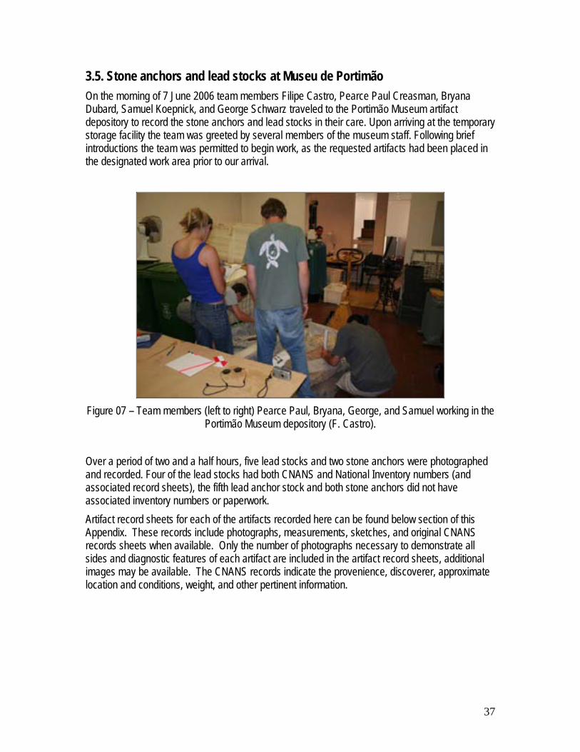
3.5. Stone anchors and lead stocks at Museu de Portimão On the morning of 7 June 2006 team members Filipe Castro, Pearce Paul Creasman, Bryana Dubard, Samuel Koepnick, and George Schwarz traveled to the Portimão Museum artifact depository to record the stone anchors and lead stocks in their care. Upon arriving at the temporary storage facility the team was greeted by several members of the museum staff. Following brief introductions the team was permitted to begin work, as the requested artifacts had been placed in the designated work area prior to our arrival.
Figure 07 – Team members (left to right) Pearce Paul, Bryana, George, and Samuel working in the
Portimão Museum depository (F. Castro). Over a period of two and a half hours, five lead stocks and two stone anchors were photographed and recorded. Four of the lead stocks had both CNANS and National Inventory numbers (and associated record sheets), the fifth lead anchor stock and both stone anchors did not have associated inventory numbers or paperwork. Artifact record sheets for each of the artifacts recorded here can be found below section of this Appendix. These records include photographs, measurements, sketches, and original CNANS records sheets when available. Only the number of photographs necessary to demonstrate all sides and diagnostic features of each artifact are included in the artifact record sheets, additional images may be available. The CNANS records indicate the provenience, discoverer, approximate location and conditions, weight, and other pertinent information.

38
Figure 08 – Lead anchor stocks and respective CNANS Nos. (F. Castro)

39
3.6. Stone Anchors – Atlantic Diving Albufeira On the morning of 14 June 2006 team members Filipe Castro, Pearce Paul Creasman, Bryana Dubard, Tiago Fraga, Samuel Koepnick, and George Schwarz traveled to a dive shop in Albufeira to record numerous stone anchors known to be in their possession. Upon arriving there, to find the shop closed, the team looked around the premises and found four stone anchors, two possible stone anchors, and three modern iron anchors. At least twelve stone anchors, one lead anchor stock, and two iron anchors are known to have been displayed at this shop in the early 1990s (see collage below and Appendix 4). The whereabouts of the missing stone anchors are unknown. In order to most efficiently record the remaining anchors, the team split up into four small groups and each was assigned anchors to record.
Figure 09 – Team members (left to right) Samuel, George, and Bryana recording stone anchors in
Albufeira (F. Castro) Two of the stone artifacts recorded in Albufeira do not fit in the typical appearance of stone anchors. One is clearly a millstone that may have been adapted for use as stone anchor. The second is a small rectangular stone wrapped in a nylon rope grid and may have been used as an octopus-pot line anchor or a fishing net anchor. Evidence suggests that the artifacts found here came from a site in front of Portimão and not from Ponta da Piedade, Lagos, as it was previously thought.
Figure 10 – Collage of twelve stone anchors known to have been at the dive shop in the early
1990s (F. Castro). See Appendix 4.

40
Artifact record sheets of each of the six stone artifacts recorded here can be found in the end of this Appendix. These records include photographs, measurements, and sketches. Only the number of photographs necessary to demonstrate all diagnostic features of each artifact are included in the artifact record sheets, additional images may be available.

41
Artifact Sheets

42
Lagos Summer School 2006 Artifact Sheet 3.01. Iron Anchor Location: Motel Âncora Description: Large iron anchor Approximate date: 19th century History: The receptionist of the Motel told us that she thought that the anchor was brought up in the nets off Gibraltar, in the early 1970s. It was brought to Olhão where it was bought by the owner of Motel Âncora and placed where it stands today. The stock seems to have been made at that time. CNANS Catalog No.: NA INSAS No.: NA Date(s) Recorded: June 5th Recorded by: F.Castro, T.Fraga, P.Creasman, B.DuBard, G.Schwarz, S.Koepnick. Basic measurements:
Maximum Length: 5.34 m Maximum Width: 3.21 m
Picture 1 Picture 2

43
Picture 3 Picture 4
Sketch 1 Sketch 2
Computer rendering

44
Composite Picture Rendered anchor replacing the real on in the picture:
Documents

45
Lagos Summer School 2006 Artifact Sheet 3.02. Iron Anchor Location: City Walls Description: Large iron anchor Approximate date: 15th or 16th century History: This anchor has been found near the place where it stands today (pers. Comm. Dr. Rui Loureiro) CNANS Catalog No.: NA INSAS No.: NA Date(s) Recorded: June 5th Recorded by: F.Castro, T.Fraga, P.Creasman, B.DuBard, G.Schwarz, S.Koepnick. Basic measurements:
Maximum Length: 4.17 m Maximum Width: 2.56 m
Picture 1 Picture 2
Picture 3 Picture 4

46
Picture 5 Picture 6
Sketch 1 Sketch 2
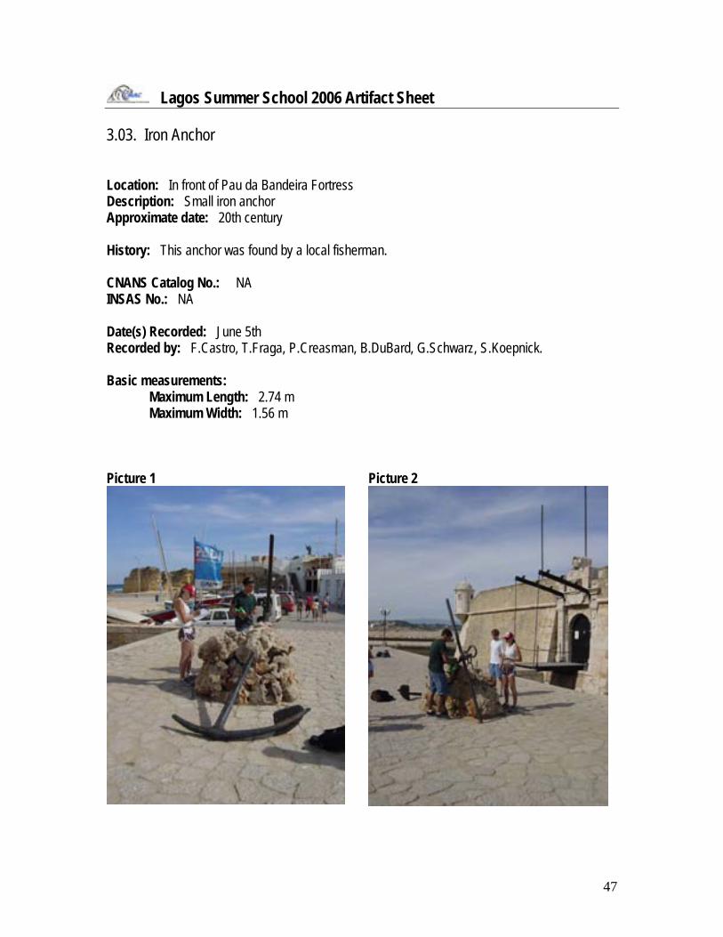
47
Lagos Summer School 2006 Artifact Sheet 3.03. Iron Anchor Location: In front of Pau da Bandeira Fortress Description: Small iron anchor Approximate date: 20th century History: This anchor was found by a local fisherman. CNANS Catalog No.: NA INSAS No.: NA Date(s) Recorded: June 5th Recorded by: F.Castro, T.Fraga, P.Creasman, B.DuBard, G.Schwarz, S.Koepnick. Basic measurements:
Maximum Length: 2.74 m Maximum Width: 1.56 m
Picture 1 Picture 2

48
Picture 3 Picture 4
Sketch 1 Sketch 2

49
Lagos Summer School 2006 Artifact Sheet 3.04. Iron Grapnel Location: In front of Pau da Bandeira Fortress Description: Small iron anchor Approximate date: 20th century History: This anchor was found by a local fisherman. CNANS Catalog No.: NA INSAS No.: NA Date(s) Recorded: June 5th Recorded by: F.Castro, T.Fraga, P.Creasman, B.DuBard, G.Schwarz, S.Koepnick. Basic measurements:
Maximum Length: 2.74 m Maximum Width: 1.56 m
Picture 1 Picture 2

50
Picture 3 Picture 4
Picture 5 Picture 6
Picture 7 Picture 8

51
Sketch 1 Sketch 2

52
Lagos Summer School 2006 Artifact Sheet 3.05. Stone Anchor Location: Museu de Portimão Description: Stone anchor with three holes Approximate date: Unknown History: Found in a well-known area in from of the Arade River mouth, possibly an old fishing ground. CNANS Catalog No.: INSAS No.: Date(s) Recorded: 7 June 2006 Recorded by: Sam Koepnick Basic measurements:
Maximum Length: 51.8 cm Maximum Width: 38.2 cm
Picture 1 Picture 2

53
Picture 3
Picture 4
Picture 5

54
Sketch 1
Drawing Documents Observations

55
Lagos Summer School 2006 Artifact Sheet 3.06. Stone Anchor Location: Museu de Portimão Description: Stone anchor with three holes Approximate date: Unknown History: Found in a well-known area in from of the Arade River mouth, possibly an old fishing ground. CNANS Catalog No.: INSAS No.: Date(s) Recorded: 7 June 2006 Recorded by: Bryana DuBard, George Schwarz Basic measurements:
Maximum Length: 58.0 cm Maximum Width: 34.0 cm
Picture 1 Picture 2

56
Picture 3
Sketch 1

57
Sketch 2
Drawing Documents Observations

58
Lagos Summer School 2006 Artifact Sheet 3.07. Lead Anchor Stock Location: Museu de Portimão Description: Lead anchor stock. Approximate date: Unknown History: CNANS Catalog No.: 86 INSAS No.: 5481 Date(s) Recorded: 7 June 2006 Recorded by: Bryana DuBard, George Schwarz Basic measurements:
Maximum Length: 92.5 cm Maximum Width: 12.4 cm
Picture 1
Picture 2

59
Picture 3
Picture 4
Sketch 1

60
Drawing Documents

61
Observations

62
Lagos Summer School 2006 Artifact Sheet 3.08. Lead Anchor Stock Location: Museu de Portimão Description: Lead anchor stock. Approximate date: Unknown History: CNANS Catalog No.: INSAS No.: Date(s) Recorded: 7 June 2006 Recorded by: Filipe Castro, Pearce Paul Creasman Basic measurements:
Maximum Length: 91.0 cm Maximum Width: 14.5 cm
Picture 1
Picture 2

63
Picture 3
Picture 4
Picture 5

64
Sketch 1
Drawing Documents Observations

65
Lagos Summer School 2006 Artifact Sheet 3.09. Lead Anchor Stock Location: Museu de Portimão Description: Lead Anchor Stock Approximate date: History: CNANS Catalog No.: 82 INSAS No.: 5247 Date(s) Recorded: 7 June 2006 Recorder(s): Pearce Paul Creasman Basic measurements: Maximum Length: 157.5 cm Maximum Width: 23.6 cm Picture 1
Picture 2
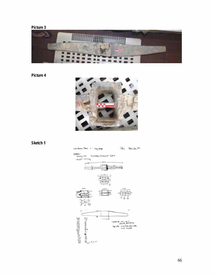
66
Picture 3
Picture 4
Sketch 1

67
Drawing Documents
Observations

66
Lagos Summer School 2006 Artifact Sheet 3.10. Lead Anchor Stock Location: Museu de Portimão Description: Lead anchor stock. Approximate date: Unknown History: CNANS Catalog No.: 90 INSAS No.: 5482 Date(s) Recorded: 7 June 2006 Recorded by: Filipe Castro, Pearce Paul Creasman Basic measurements:
Maximum Length: 91.0 cm Maximum Width: 17.0 cm
Picture 1
Picture 2

67
Picture 3
Picture 4

68
Sketch 1 Sketch 2
Drawing Documents

69
Observations

70
Lagos Summer School 2006 Artifact Sheet 3.11. Lead Anchor Stock Location: Museu de Portimão Description: Lead anchor stock. Approximate date: Unknown History: CNANS Catalog No.: 85 INSAS No.: 5480 Date(s) Recorded: 7 June 2006 Recorded by: Filipe Castro, Pearce Paul Creasman Basic measurements:
Maximum Length: 83.0 cm Maximum Width: 12.0 cm
Picture 1
Picture 2

71
Picture 3
Picture 4
Picture 5

72
Sketch 1
Drawing Documents

73
Observations

74
Lagos Summer School 2006 Artifact Sheet 3.12. Stone Anchor Location: Albufeira – Atlantic Diving Description: Cuboid stone in nylon netting Approximate date: Unknown History: Previously recovered in front of Portimão CNANS Catalog No.: INSAS No.: Date(s) Recorded: 14 June 2006 Recorded by: Bryana DuBard, George Schwarz Basic measurements:
Maximum Length: 26.5 cm Maximum Width: 18.5 cm
Picture 1 (Composite)
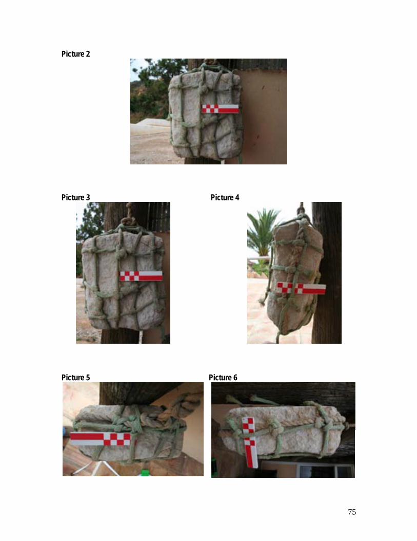
75
Picture 2
Picture 3 Picture 4
Picture 5 Picture 6

76
Sketch 1
Drawing
Documents Observations

77
Lagos Summer School 2006 Artifact Sheet 3.13. Stone Anchor/ Millstone 1 Location: Albufeira - Atlantic Diving Description: Stone anchor, converted millstone Approximate date: Unknown History: Previously recovered in front of Portimão CNANS Catalog No.: INSAS No.: Date(s) Recorded: 14 June 2006 Recorded by: Sam Koepnick Basic measurements:
Maximum Radius (from center): 16.0 cm Maximum Thickness: 15.4 cm
Picture 1 (composite)

78
Picture 2
Sketch 1

79
Drawing
Documents Observations

80
Lagos Summer School 2006 Artifact Sheet 3.14. Stone Anchor Location: Albufeira - Atlantic Diving Description: Stone anchor with three holes Approximate date: Unknown History: Previously recovered in front of Portimão CNANS Catalog No.: INSAS No.: Date(s) Recorded: 14 June 2006 Recorded by: Bryana DuBard, George Schwarz Basic measurements:
Maximum Length: 42.5 cm Maximum Width: 35.0 cm
Picture 1 (composite)

81
Picture 2 Picture 3 Picture 4
Picture 5
Picture 6

82
Sketch 1
Drawing
Documents Observations

83
Lagos Summer School 2006 Artifact Sheet 3.15. Stone Anchor Location: Albufeira - Atlantic Diving Description: Stone anchor with two holes, one is pear-shaped Approximate date: Unknown History: Previously recovered in front of Portimão CNANS Catalog No.: INSAS No.: Date(s) Recorded: 14 June 2006 Recorded by: Filipe Castro, Tiago Fraga Basic measurements:
Maximum Length: 39.0 cm Maximum Width: 26.0 cm
Picture 1

84
Picture 2 Picture 3 Picture 4
Picture 5 Picture 6

85
Sketch 1 Sketch 2
Drawing
Documents Observations
86
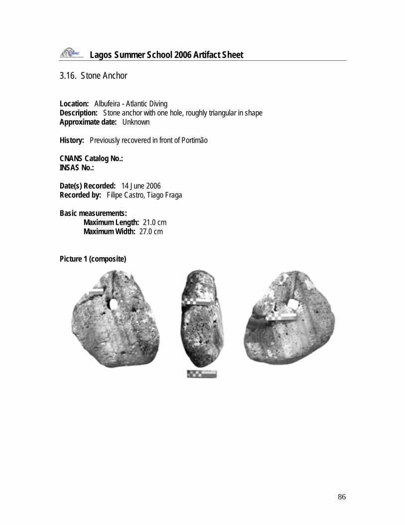
Lagos Summer School 2006 Artifact Sheet 3.16. Stone Anchor Location: Albufeira - Atlantic Diving Description: Stone anchor with one hole, roughly triangular in shape Approximate date: Unknown History: Previously recovered in front of Portimão CNANS Catalog No.: INSAS No.: Date(s) Recorded: 14 June 2006 Recorded by: Filipe Castro, Tiago Fraga Basic measurements:
Maximum Length: 21.0 cm Maximum Width: 27.0 cm
Picture 1 (composite)

87
Picture 2 Picture 3
Picture 4 Picture 5

88
Sketch 1 Sketch 2
Drawing
Documents Observations

89
Lagos Summer School 2006 Artifact Sheet 3.17. Stone Anchor Location: Albufeira - Atlantic Diving Description: Stone anchor with two holes vertically aligned Approximate date: Unknown History: Previously recovered in front of Portimão CNANS Catalog No.: INSAS No.: Date(s) Recorded: 14 June 2006 Recorded by: Pearce Paul Creasman Basic measurements:
Maximum Length: 45.0 cm Maximum Width: 37.0 cm
Picture 1

90
Picture 2 (1993) Picture 2 (2006)
Picture 3

91
Sketch 1
Drawing
Documents Observations

92
Appendix 4
Inquiry

93
4.1. Introduction Among the first objectives of the 2006 Summer School was the development of an inquiry and inventory of the nautical cultural heritage of the Municipality of Lagos. A number of artifacts has been found and stored in both public institutions and private collections, and part of the Texas A&M University – Institute of Nautical Archaeology team was to inquire into the artifact’s proveniences and possible unknown shipwreck sites. The following sites were planned to be inspected or visited:
1) Âncoras de Pedra – Atlantic Diving Albufeira 2) Lagos 2 shipwreck 3) Lagos 3 shipwreck 4) Ponta da Piedade 1 site 5) Pedra do Calvario site 6) Mr. Graca Mira artifact collection 7) Portimão stone anchors (Mr. Stephan Fend) 8) Boca do Rio shipwreck 9) Martinhal 1 shipwreck 10) Martinhal 2 shipwreck 11) Praia da Galé shipwreck
4.2. Âncoras de Pedra – Atlantic Diving Albufeira A number of stone anchors was recovered in the late 1980s and early 1990s by divers of the Atlantic Diving Club of Albufeira and Dr. Filipe Castro had seen them and taken pictures in 1993, when he visited the site with the then director of Lisbon’s Museu Nacional de Arqueologia, Dr. Francisco Alves. Some of the anchors had disappeared and nobody could tell us where they were. The team proceeded with the recording of the remaining anchors (see Appendix 3). Mr. Stephan Fend, from another diving club told us that all these anchors seemed to have been recovered from a fishing site situated in front of Portimão, where there are still many stone anchors. Because he takes tourists there the place is under surveillance and it is unlikely that more anchors will be removed. A visit to the underwater site was scheduled but not carried out for lack of time (see 4.15 below).

94
4.3. Lagos 2 shipwreck Lagos 2 shipwreck is a somehow mysterious reference in the chart (Figure 23). Neither fishermen, nor divers seem to have seen this shipwreck and an inquiry carried out by Tiago Fraga near Instituto Hidrografico – the institution that issues the charts – did not shed any light over this subject.
Figure 23 – Position of the supposed Lagos 2 shipwreck in the chart.
4.4. Lagos 3 site – Ferro da Velha Madrid This site has been described as just a recent anchor from a tuna trap and as a complex that encompasses a large anchor and a shallow mound of concretions covered with lost fishermen nets (Figure 24).
Figure 24 – Position of the supposed Lagos 3 site.

95
4.5. Ponta da Piedade 1 site Ponta da Piedade 1, in Lagos, is a 20 m deep site and was not dived on by our team this season. In 1993 a team from Museu Nacional de Arqueologia recovered three stone anchors from this site, which are now stored at Centro Nacional de Arqueologia Náutica e Subaquática, in Lisbon.
Figure 25 – A rocky section West of Ponta da Piedade (P. Creasman)
4.6. Pedra do Calvário site This site is not a confirmed shipwreck site, but it seems to be a point of interest. It was not visited this time for lack of time. Tiago Fraga gathered all the information available about this site, where amphora shards – thought to be Punic (Proc. CNANS 0066) – and an iron anchor have been sighted (Figure 26).
Figure 26 – Anchor from Pedra do Calvário (CNANS Archives).

96
4.7. Mr. Graça Mira artifact collection Mr. Graça is a local resident of Lagos who is said to have amassed an important collection of artifacts. Although planned, it was not possible to visit Mr. Mira during the summer of 2006.
4.8. Portimão stone anchors (Mr. Stephan Fend) Mr. Stephan Fend regularly takes tourists to a site in front of Portimão where there is an important number of stone anchors. Most, if not all, of the stone anchors recorded at Atlantic Diving are thought to come from this site (see 4.2. above). It was not possible to visit that site during the summer of 2006 for lack of time.
4.9. Boca do Rio shipwreck A Lagos resident offered to show us the site of a potential shipwreck where a number of amphorae is said to be apparent, in front of Boca do Rio archaeological site, when there is less sand. It is not certain to that this context corresponds to a shipwreck because the coast has possibly receded as much as 300 m or more since Roman times. The team visited the site on June 12 (Figure 27).
Figure 27 – Boca do Rio (F. Castro).

97
4.10. Martinhal 1 shipwreck A number of amphorae and a lead stock have been found around the islets in from of this beach. The team visited the site on June 12 (Figure 28).
Figure 28 – Martinhal (F. Castro).
4.11. Martinhal 2 shipwreck A number of iron guns has been sighted near one of the islets in front of this beach and may correspond to the site of the shipwreck a Spanish patacho lost in this area in the first decade of the 17th century. The team visited the site on June 12.
4.12. Praia da Galé shipwreck A bronze gun and a number of anchors have been found off this beach, near Albufeira. The team visited the site on June 14 (Figures 29 and 30).
Figure 29 – Praia do Lourenço (F. Castro).

98
This site’s interest and the number and quality of the artifacts that are said to have been found in it should justify further study.
Figure 30 – Praia do Lourenço (F. Castro).

99
Lagos Summer School 2006 Artifact Sheet 4.01. Stone Anchor Location: Albufeira - Atlantic Diving Description: Stone anchor, very thick Approximate date: Unknown History: Previously recovered in front of Portimão CNANS Catalog No.: INSAS No.: Date(s) Recorded: 1993 Recorded by: Filipe Castro Basic measurements:
Maximum Length: unknown Maximum Width: unknown
Picture 1

100
Drawing Documents Observations: Missing in 2006

101
Lagos Summer School 2006 Artifact Sheet 4.02. Stone Anchor Location: Albufeira - Atlantic Diving Description: Stone anchor with one hole, rectangular shape with two missing corners, circular growths or impressions Approximate date: Unknown History: Previously recovered in front of Portimão CNANS Catalog No.: INSAS No.: Date(s) Recorded: 1993 Recorded by: Filipe Castro Basic measurements:
Maximum Length: unknown Maximum Width: unknown
Picture 1

102
Picture 2
Drawing
Documents Observations: Missing in 2006

103
Lagos Summer School 2006 Artifact Sheet 4.3. Stone Anchor Location: Albufeira - Atlantic Diving Description: Stone anchor with one hole, welll rounded edges Approximate date: Unknown History: Previously recovered in front of Portimão CNANS Catalog No.: INSAS No.: Date(s) Recorded: 1993 Recorded by: Filipe Castro Basic measurements:
Maximum Length: unknown Maximum Width: unknown
Picture 1

104
Picture 2
Drawing
Documents Observations: Missing in 2006

105
Lagos Summer School 2006 Artifact Sheet 4.04. Stone Anchor Location: Albufeira - Atlantic Diving Description: Stone anchor with three holes and upward indentation in bottom face Approximate date: Unknown History: Previously recovered in front of Portimão CNANS Catalog No.: INSAS No.: Date(s) Recorded: 1993 Recorded by: Filipe Castro Basic measurements:
Maximum Length: unknown Maximum Width: unknown
Picture 1

106
Picture 2
Drawing
Documents Observations: Missing in 2006

107
Lagos Summer School 2006 Artifact Sheet 4.05. Stone Anchor Location: Albufeira - Atlantic Diving Description: Stone anchor with two holes, one hole is proportionately very large Approximate date: Unknown History: Previously recovered in front of Portimão CNANS Catalog No.: INSAS No.: Date(s) Recorded: 1993 Recorded by: Filipe Castro Basic measurements:
Maximum Length: unknown Maximum Width: unknown
Picture 1

108
Picture 2
Drawing
Documents Observations: Missing in 2006

109
Lagos Summer School 2006 Artifact Sheet 4.06. Stone Anchor Location: Albufeira - Atlantic Diving Description: Stone anchor with one hole Approximate date: Unknown History: Previously recovered in front of Portimão CNANS Catalog No.: INSAS No.: Date(s) Recorded: 1993 Recorded by: Filipe Castro Basic measurements:
Maximum Length: unknown Maximum Width: unknown
Picture 1

110
Picture 2
Drawing
Documents Observations: Missing in 2006

111
Lagos Summer School 2006 Artifact Sheet 4.07. Stone Anchor Location: Albufeira - Atlantic Diving Description: Stone anchor with three holes, flat bottom and rounded top Approximate date: Unknown History: Previously recovered in front of Portimão CNANS Catalog No.: INSAS No.: Date(s) Recorded: 1993 Recorded by: Filipe Castro Basic measurements:
Maximum Length: unknown Maximum Width: unknown
Picture 1

112
Picture 2
Drawing
Documents Observations: Missing in 2006

113
Lagos Summer School 2006 Artifact Sheet 4.08. Stone Anchor Location: Albufeira - Atlantic Diving Description: Stone anchor with four holes, three unaligned at bottom and one at top Approximate date: Unknown History: Previously recovered in front of Portimão CNANS Catalog No.: INSAS No.: Date(s) Recorded: 1993 Recorded by: Filipe Castro Basic measurements:
Maximum Length: unknown Maximum Width: unknown
Picture 1

114
Picture 2
Drawing
Documents Observations: Missing in 2006
115
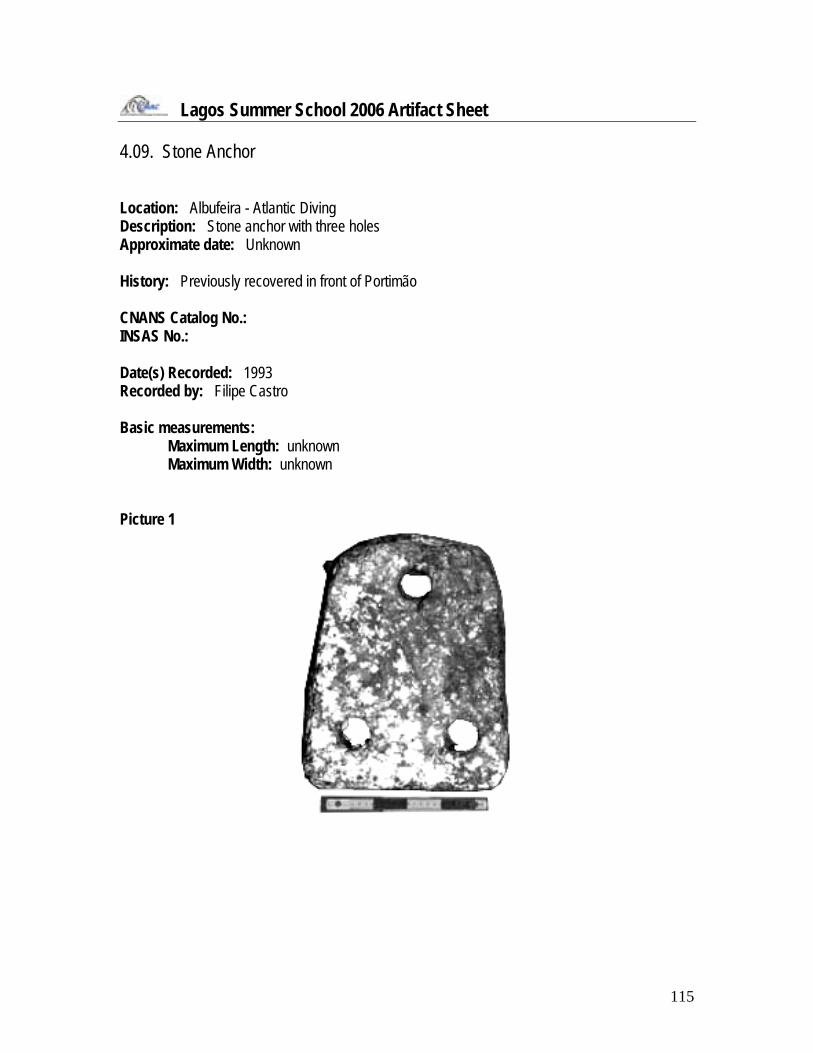
Lagos Summer School 2006 Artifact Sheet 4.09. Stone Anchor Location: Albufeira - Atlantic Diving Description: Stone anchor with three holes Approximate date: Unknown History: Previously recovered in front of Portimão CNANS Catalog No.: INSAS No.: Date(s) Recorded: 1993 Recorded by: Filipe Castro Basic measurements:
Maximum Length: unknown Maximum Width: unknown
Picture 1

116
Picture 2
Drawing
Documents Observations: Missing in 2006

117
Lagos Summer School 2006 Artifact Sheet 4.10. Stone Anchor Location: Albufeira - Atlantic Diving Description: Stone anchor with four holes, three unaligned at bottom close together Approximate date: Unknown History: Previously recovered in front of Portimão CNANS Catalog No.: INSAS No.: Date(s) Recorded: 1993 Recorded by: Filipe Castro Basic measurements:
Maximum Length: unknown Maximum Width: unknown
Picture 1

118
Picture 2
Drawing
Documents Observations: Missing in 2006

119
Lagos Summer School 2006 Artifact Sheet 4.11. Stone Anchor Location: Albufeira - Atlantic Diving Description: Stone anchor profile, other features not discernable from photograph Approximate date: Unknown History: Previously recovered in front of Portimão CNANS Catalog No.: INSAS No.: Date(s) Recorded: 1993 Recorded by: Filipe Castro Basic measurements:
Maximum Length: unknown Maximum Width: unknown
Picture 1
Drawing Documents Observations: Missing in 2006

120
Lagos Summer School 2006 Artifact Sheet 4.12. Lead Anchor Stock Location: Albufeira - Atlantic Diving Description: Lead Anchor Stock Approximate date: Unknown History: Previously recovered in front of Portimão CNANS Catalog No.: INSAS No.: Date(s) Recorded: 1993 Recorded by: Filipe Castro Basic measurements:
Maximum Length: unknown Maximum Width: unknown
Picture 1
Picture 2

121
Drawing Documents Observations: Missing in 2006

122
Lagos Summer School 2006 Artifact Sheet 4.13. Stone Anchor Location: CNANS Description: Stone anchor with three holes Approximate date: Unknown History: Previously recovered at Ponta da Piedade 1 at a depth of 20 m. CNANS Catalog No.: 4639.0001 INSAS No.: Date(s) Recorded: 1993 Recorded by: Basic measurements:
Maximum Length: 54 cm Maximum Width: 44 cm
Documents

123
Lagos Summer School 2006 Artifact Sheet 4.14. Stone Anchor Location: CNANS Description: Stone anchor with two holes Approximate date: Unknown History: Previously recovered at Ponta da Piedade 1 at a depth of 20 m. CNANS Catalog No.: 4639.0003 INSAS No.: Date(s) Recorded: 1993 Recorded by: Basic measurements:
Maximum Length: 53.5 cm Maximum Width: 24 / 36.5 cm
Documents

124
Lagos Summer School 2006 Artifact Sheet 4.15. Stone Anchor Location: CNANS Description: Stone anchor with two holes Approximate date: Unknown History: Previously recovered at Ponta da Piedade 1 at a depth of 20 m. CNANS Catalog No.: 4639.0002 INSAS No.: Date(s) Recorded: 1993 Recorded by: Basic measurements:
Maximum Length: 33 cm Maximum Width: 20.5 / 35 cm
Documents

125
Appendix 5
Non-Intrusive Surveys

126
5.1. Introduction Seven non-intrusive surveys of underwater sites with archaeological potential were planned for this summer and carried out. Those who produced artifacts or those , as mentioned above, in Appendix 4:
1) Lagos 1 shipwreck 2) Lagos 4 shipwreck 3) Lagos 5 shipwreck 4) Ponta da Piedade 2 site 5) Ponta da Piedade 3 site 6) Praia da Luz shipwreck 7) Iron gun from Cama da Vaca 1
5.2. Lagos 1 shipwreck – Meia Praia Introduction Meia Praia is a site that was surveyed during the 2006 summer field school in Lagos. It is a long stretch of beach situated between Lagos and Portimão (Figures 31 and 32).
Figure 31 – Location of the Meia Praia site in the chart.

127
Figure 32 – Location of the Meia Praia site according to witnesses.
The waters off this beach are reportedly rich in artifacts spanning many centuries. In August 2005, Guilherme Neves, a long-time volunteer of underwater archaeological surveys, was informed of a possible Roman vessel lying in the waters off Meia Praia. The informant, a local fisherman from Lagos, had been collecting assorted pieces of ceramics in his fishing nets for many years. The fisherman, Sr. Zè, was dragging his mesh nets in the area of Meia Praia from the shoreline out into the bay, approximately 400 meters, with the help of his boat. His finds include ceramic shards from ancient, medieval, and modern eras (Figure 33).
Figure 33 – Previously recovered artifacts (CNANS Archives).

128
Sr. Zé had been doing this for so long that he had pieces in his collection from over 30 years ago, before the dredging of the neighboring port of Lagos. Neves was taken to the sites indicated by Sr. Zé, and dived on many, which were then marked with a handheld GPS device for a future survey of the area. In 12 meters of water, Neves and another diver found a fragment of ceramic and one piece of a timber, possibly from a shipwreck. It is at this point in the investigation that nautical archaeologists from the municipality of Lagos, and Texas A&M University began the survey of Meia Praia. Characteristics of the site Meia Praia is located in the bay of Lagos, situated in the middle of two river banks between Lagos and Portimão (Figures 31 and 34). It has been known historically as a place used frequently for beaching ships, disembarking for voyages, and supplying vessels with water. There are numerous references to archaeological finds in this area, such as the one mentioned above. Because the area is a high-energy zone, many of the artifacts are normally buried under deep deposits of sand. Fortunately, this summer was an excellent opportunity to survey the area with divers because much of the sand had, in most areas, receded further than it had in many years. Since this is a high-energy zone, there is likely no clearly distinguishable matrix in which the ceramics and other artifacts were deposited. Moreover, it is probable that the deposition had been further disturbed from the tsunami created from the 1755 earthquake, which had its epicenter near Lisbon. Lagos was reported to have had 30 meter tidal waves that jumped over the city walls. The results of the survey were analyzed with this historical perspective in mind.
Figure 34 – View of Meia Praia as seen from Lagos (P. Creasman).
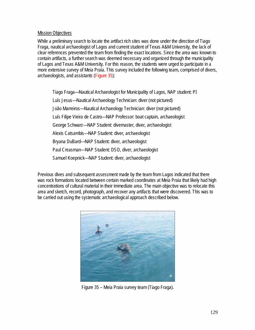
129
Mission Objectives While a preliminary search to locate the artifact rich sites was done under the direction of Tiago Fraga, nautical archaeologist of Lagos and current student of Texas A&M University, the lack of clear references prevented the team from finding the exact locations. Since the area was known to contain artifacts, a further search was deemed necessary and organized through the municipality of Lagos and Texas A&M University. For this reason, the students were urged to participate in a more extensive survey of Meia Praia. This survey included the following team, comprised of divers, archaeologists, and assistants (Figure 35):
Tiago Fraga—Nautical Archaeologist for Municipality of Lagos, NAP student: PI Luís Jesus—Nautical Archaeology Technician: diver (not pictured) João Marreiros—Nautical Archaeology Technician: diver (not pictured) Luís Filipe Vieira de Castro—NAP Professor: boat captain, archaeologist George Schwarz—NAP Student: divemaster, diver, archaeologist Alexis Catsambis—NAP Student: diver, archaeologist Bryana DuBard—NAP Student: diver, archaeologist Paul Creasman—NAP Student: DSO, diver, archaeologist Samuel Koepnick—NAP Student: diver, archaeologist
Previous dives and subsequent assessment made by the team from Lagos indicated that there was rock formations located between certain marked coordinates at Meia Praia that likely had high concentrations of cultural material in their immediate area. The main objective was to relocate this area and sketch, record, photograph, and recover any artifacts that were discovered. This was to be carried out using the systematic archaeological approach described below.
Figure 35 – Meia Praia survey team (Tiago Fraga).

130
Methodology Using previously obtained coordinates that were marked on a hand held GPS device, the team proceeded to make a base line from which to survey the area with SCUBA divers. Either end of a 100 meter line was secured to a 20 kg cement weight. This line was marked at 5 meter intervals by zip ties and vellum tags indicating the distance from one end of the base line to the other. Once the project boat was positioned directly over the first GPS coordinate, one end of the line, along with the cement weight, was dropped into the water (Figure 36). The cement weight was also attached to a line with a buoy, in order to locate it on the surface. The boat then proceeded in the direction of the next coordinate, and once a 100 meter distance had been traversed, the other end of the baseline was dropped into the water. Once this baseline was surveyed by divers, the line was lifted and another set of coordinates was used to lay another baseline. This technique was systematically employed in a zigzag type pattern until the predetermined survey area was fully covered by divers.
Figure 36 – Deploying baseline (Sam Koepnick).
After the baselines were set in place, the divers were sent into the water. The average depth was approximately 15 meters, and the average dive lasted about 40 minutes. The visibility was usually around 4 meters, which meant the divers had to stay close together while searching for artifacts along the baseline. This way, once an object was discovered, the rest of the team could be alerted to assist in the recording and recovering of the artifact. The divers searched in a line perpendicular to the baseline, in order to cover as much distance as possible, as well as stay together so the team could operate with each other. The methodology of the diving survey was as follows: one diver stayed in close proximity to the line (1 meter) so the entire team could stay in the same vertical plane without having to see the line itself (Figure 37). The next diver was positioned approximately 3 meters from the first diver. The rest of the divers were separated similarly, so that they could see divers on either side of them. In this way, with 4 divers, the team covered approximately 15 meters on one side of the baseline per 100 meter stretch. Arranged in this fashion, once the divers reached the end of the baseline, they

131
surveyed the other side of the line, covering a total of a 30 meter-wide swath from the center of the baseline. This methodology was used for each baseline that was laid throughout the survey of the Meia Praia site.
Figure 37 – Running the baseline (P. Creasman).
In a few cases, deviation from this method was necessary to relocate an object that was discovered on one dive but not recovered or recorded for various reasons. In these cases, a dive reel was attached to a point on the baseline and unwound perpendicularly to the direction of the baseline. Once a predetermined distance, for example 6 meters, was reached, arc-shaped swaths were made in order to relocate a previously discovered artifact. This method worked quite well, and prevented the divers from losing each other or straying from the original baseline.
Results The survey area was investigated daily in this manner for two weeks. During that time, archaeologists from the team recovered several artifacts from the Meia Praia area. Once the artifacts were found, they were sketched and photographed in situ (Figures 38 and 39), then gently recovered and brought to the surface for further examination and ultimately for conservation. A list of the artifacts recovered from the survey is as follows: T0001 - charcoal fragment with distinctive marks
T0009 - ceramic piece
T0002 - 4 pieces of charcoal T0010 - volcanic rock, perhaps ballast T0003 - decorative ceramic cup fragment with handle
T0011 - charcoal piece
T0004 - plate fragment with blue decoration T0012 - sandstone, grit

132
T0005 - nail concretion T0013 - ceramic cup T0006 - ceramic piece T0014 - aluminum buoy T0007 - possible axe fragment T0015 - mill stone T0008 - possible soup plate While many of these artifacts could have come from a shipwreck, their actual provenience is unknown. Several objects could easily have been washed into the bay during the tsunami in 1755.
Figure 38 – Photo of mill stone in situ
(P. Creasman). Figure 39 – Recording artifacts underwater
(P. Creasman). Despite the fact that no conclusive evidence of a wreck has yet been discovered, the project was a good preliminary survey of the area. The students and other participants learned a good deal about surveying techniques using baselines and SCUBA divers performing search patterns in order to systematically search for submerged cultural material. Stone Anchors On the second dive of 20 June 2006, our team found a large stone anchor at the east end of one of our search lines. The anchor, made of a marbled white and yellow stone, has been used in recent times. The second photograph below shows a close up of the hole running through the anchor, with nylon rope looped through three times. The anchor was too heavy for any one of our team to lift off the seabed, was approximately one meter across at its widest point, and at least half a meter thick. Sharp edges suggest that this anchor was harvested on land and lost recently.

133
Figures 40 and 41 – Stone anchor found at Meia Praia (P. Creasman)
A millstone that may, or may not, have been used as an anchor was also found at Meia Praia. The team found this millstone early in the season, but visibility was too poor to obtain a photograph of anything more than half a meter away. Toward the end of the season, on 19 June 2006, the team dived a grid near the location where the millstone was found and at the end of the dive two divers were able to relocate the millstone and take photographs. The millstone was about half a meter at maximum diameter and about ten centimeters thick. The edges are well rounded, as too be expected, and several types of marine life have grown over the surface of the artifact. No diagnostic markings were found on the uppermost surface or edges of the millstone. The artifact was left in situ as it provides a good marker for one portion of our search grid.
Figure 42 – Millstone found at Meia Praia (P. Creasman)
Conclusions and Further Work Unfortunately, no ship timbers were discovered during the survey. Neither was their any other direct evidence of shipwrecks in this area, other than the scattered artifacts found from this and previous surveys. A more in-depth survey using specialized equipment such as sub-bottom profiler,

134
magnetometer, and side-scan devices is necessary to find evidence of shipwrecks buried beneath the sand in this area. This project did, however, provide information about the geography of the area, as well as potential ‘hot spots’ for future surveys. Since this is a historically significant area in terms of maritime life, it is worthwhile to continue searching this area for shipwreck remains. This culturally rich area very likely contains some buried remains of ships from all eras of Portuguese history, and has high potential to yield important archaeological and historical information in future surveys.
5.3. Lagos 4 shipwreck This site was located during a survey carried out by Instituto Hidrográfico off the Bay of Lagos. It was surveyed by a team and found to be a large metal barge, dating to the 20th century, and laying upside down (Figures 43 to 46).
Figure 43 – Bow door (B. Ringsell). Figure 44 – Bow door hinge (B. Ringsell).
Figure 45 – One of the two propellers
(B. Ringsell). Figure 46 – Stairs on one of the barge sides
(B. Ringsell).

135
5.4. Lagos 5 shipwreck This site was also located during a survey carried out by Instituto Hidrográfico off the Bay of Lagos. It was surveyed by a small team and found to be another barge, dating to the 20th century, loaded with stones.
5.5. Ponta da Piedade 2 site Ponta da Piedade 2, or “outer anchors”, is reputed for a small number of anchors, as its common name suggests. Our team made several dives on this site over the season and found several iron anchors and iron anchor components. For most dives visibility was less than two meters, which prohibited widespread surveying. However, one potential stone anchor was found at the south-west part of the site.
Figure 47 – Possible stone anchor, outlined in red (P. Creasman)
The object could not be positively identified as a stone anchor due to exceptionally poor conditions the day it was found and photographed. Additionally, the object was heavily concreted and buried vertically in the seabed (Figure 47).
5.6. Ponta da Piedade 3 site Ponta da Piedade 3, or “inner anchors”, is said to have a few iron anchors as well. The team inspected a large iron anchor that seems to date to the late 19th or 20th century.

136
Figure 48 – Inner Anchors (P. Creasman).
An Experiment with Photomodeler at Ponta da Piedade 3 In lieu of working on either of the deeper sites, we decided to use the shallowest site at Ponta da Piedade to test the application of the Photomodeler® site mapping program that has worked so well in the crystal clear waters of Turkey. With visibility of three to four meters on the best dives, application of the program in the murky Atlantic waters proved challenging. We took one day of diving to locate a small internal site for our mapping project and settled on a three meter long iron anchor with little concretion and an interesting surrounding topography, located at the familiar site of Inner Anchors (Figure 49).
Figure 49 – Dive Master George Schwarz over the primary artifact of our Photomodeler site (P.
Creasman).

137
Our attempt at modeling the large anchor and its surrounding environment was perhaps the most educational event of the season, because it had to be repeated. Using bright yellow plastic coated weights, with bright yellow laminated tags, we set ten datum points at varying distances around the anchor and at varying depths (Figure 50). Once set, two members of the four person dive team (Alexis Catsambis and Bryana DuBard) took general measurements of the anchor and surrounding objects, to be used as comparative standards for the site and the other pair (Samuel Koepnick and Pearce Paul Creasman) measured the distances between the datum points.
Figure 50 – Dive Safety Officer and Co-PI, Pearce Paul Creasman organizing tags for datum points
(S. Koepnick).
Cameras were stored in a bag a few meters away from the primary site, in a common area, to be used by the group that finished their task first. As many photographs as possible were taken while ensuring enough time to break down the site, remove the datum points, and return slowly to the surface within the predefined allotment for air reserves in our tanks.

138
Figure 51 – One of the best quality images of
the site from the first attempt, unedited (P. Creasman).
Figure 52 – An image of the site, edited for optimum viewing. Only two datum points visible
(P. Creasman). That evening we began post-processing, only to find that the visibility was too poor to make use of about 90 percent of the photographs, even after extensive digital corrections (Figures 51 and 52). There were not enough quality photographs with the minimum of three known datum points to accurately reconstruct the anchor, much less the surrounding site. However, the yellow tags and weights proved to be excellent datum markers in these conditions. Often, the datum points could be seen when the artifacts itself could not (Figure 53).
Figure 53 – Datum points exceptional visibility in poor conditions (S. Koepnick).
After returning to work at Meia Praia for a few days, hoping that the currents would clear up the site at Inner Anchors, we planned our return. Visibility was the primary factor limiting the first attempt, and to help compensate we added a two more datum points (Figures 54 and 55). We hoped that the extra datum points placed closer to the center of our site (this time the “site” was limited to

139
mapping the anchor itself) would allow us to capture the necessary three known datum points in each image. We repeated the site set-up process stated above in 20 minutes, enough time to run out of memory on our digital cameras before we ran out of air in our tanks. On each dive we took two cameras, this dive was no exception. The housing for camera one, unbeknown to us, was jarred loose on the carrying bag on the descent to the site, probably from knocking against the weights used to mark out datum points. After only a few photographs, camera one flooded and was useless. We returned to the gear bag to retrieve camera two. We removed camera two, checked its housing, and went back to the site (Figure 56). We soon discovered that the lateral sliding lens cap on camera two was jammed, in the close position. After a few minutes trying to coax the lens cap to continue its lateral slide we abandoned hope, and the Photomodeler experiment, but with valuable lessons learned.
Diver adding datum points near the anchor, measuring, and recording distances (A. Catsambis).
Figure 54 – Original image, as seen while underwater (P. Creasman).
Figure 55 – The same image digitally enhanced (P. Creasman).
Figure 56 – Diver double-checking the camera housing (S. Koepnick).

140
Photomodeler in limited visibility is a lengthy endeavor, and from our experience, takes more time to set-up, measure, photograph, and process than hand triangulation and mapping would. Also, the smaller or less complex the site the less Photomodeler appears to be necessary. For a single artifact, such as the large anchor we attempted, this process was unnecessary, but we went in knowing this, and trying to learn more about the limits of the method. There is certainly a correlation between the size of a site, its complexity, visibility, and the viability or advantage to using Photomodeler. Since a formula for a cost-benefit analysis for the efficient use of Photomodeler on submerged sites does not exist, experimentation is probably the best method to determine its usefulness in a given situation. While our experiment at Inner Anchors was a failure, in that it did not produce a modeled plan, it was also a success in allowing us to evaluate the method’s application for future projects with a minimal investment of time and resources. 5.7. Praia da Luz 1 shipwreck The Praia da Luz 1 shipwreck is probably a recent site, right on the beach, at very low depth, and fishermen told us that a number of lead ingots have been found there, looking very recent in age. The team inspected this site on June 28 and found a very large concretion, possibly of ferrous materials at a scarce 1 m of depth. Only further work, possibly a survey with a metal detector and a small trench, will shed light on this possibly recent shipwreck site.
5.8. Praia da Luz 2 shipwreck This shipwreck is said to be the remains of a wooden hull. The team surveyed the area on June 28 but the fishermen told us that the site was covered with sand. One iron anchor was sighted near the area referenced to us, as well as a small and presumably recent grapnel.
5.9. Cama da Vaca site Introduction During the 2006 field school season, Ponta da Cama da Vaca was surveyed by students from the Nautical Archaeology Program at Texas A&M University in conjunction with Rui Manuel Loureiro and the Municipality of Lagos. The team worked under the direction of Tiago Fraga, nautical archaeologist of Lagos, and Dr. Filipe Vieira de Castro, professor at Texas A&M University.

141
Figure 57 – Map after Google Earth, 29 September 2006.
The site became of interest through information provided by CEMAL, which on 4 April 2006, reported the presence of either one or two iron cannon at Ponta da Cama da Vaca – one near the shore and one in approximately 3 m depth. This may, however, represent only one cannon, as the changing tide may account for the variations in the reported depth. This problem again arises with the input of a single line of information on 6 April 2006, stating, “There exists an iron cannon near 3 m of depth.” Once more, it is unclear whether this is the same cannon reported at 1 m depth. Inspite of the confusion, it was based upon this information that Tiago Fraga and his team of nautical archaeology technicians, Luís Jesus and João Marreiros, decided to visit the site on 24 May 2006, accompanied by Brett Ringsell, owner and operator of OSMOSIS Dive Center. Following this initial survey, a small team conducted a follow-up investigation on 29 June 2006. Characteristics of the Site The site is located within an inlet approximately 5 km west of Ponta da Piedade and just east of Burgau. There is no beach, and instead an eroded cliff meets the sea amidst a rocky subsurface terrain. Unfortunately no reference to this site in relation to the sinking of any vessel has been found within historic documents. Further research is required with regard to the historic significance of this particular area. Mission Objectives The preliminary search to locate the reported cannon on 24 May 2006, resulted in two significant finds – a cylindrical object with evidence of corroded copper and an anchor with one arm remaining.
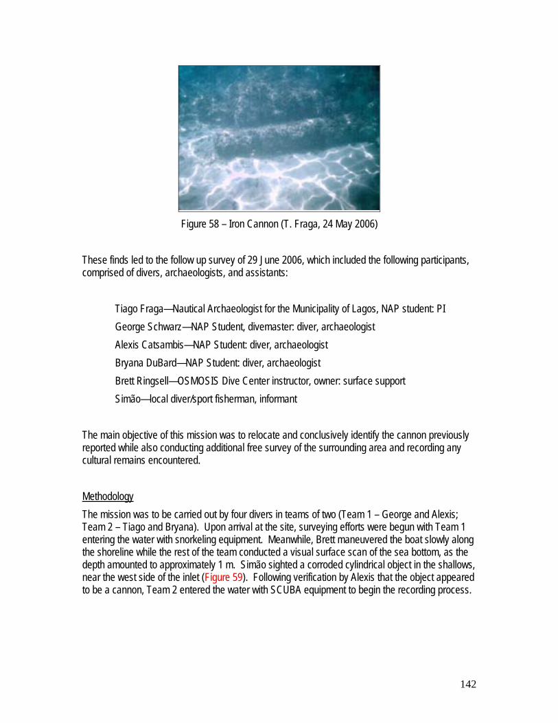
142
Figure 58 – Iron Cannon (T. Fraga, 24 May 2006)
These finds led to the follow up survey of 29 June 2006, which included the following participants, comprised of divers, archaeologists, and assistants:
Tiago Fraga—Nautical Archaeologist for the Municipality of Lagos, NAP student: PI George Schwarz—NAP Student, divemaster: diver, archaeologist Alexis Catsambis—NAP Student: diver, archaeologist Bryana DuBard—NAP Student: diver, archaeologist Brett Ringsell—OSMOSIS Dive Center instructor, owner: surface support Simão—local diver/sport fisherman, informant
The main objective of this mission was to relocate and conclusively identify the cannon previously reported while also conducting additional free survey of the surrounding area and recording any cultural remains encountered. Methodology The mission was to be carried out by four divers in teams of two (Team 1 – George and Alexis; Team 2 – Tiago and Bryana). Upon arrival at the site, surveying efforts were begun with Team 1 entering the water with snorkeling equipment. Meanwhile, Brett maneuvered the boat slowly along the shoreline while the rest of the team conducted a visual surface scan of the sea bottom, as the depth amounted to approximately 1 m. Simão sighted a corroded cylindrical object in the shallows, near the west side of the inlet (Figure 59). Following verification by Alexis that the object appeared to be a cannon, Team 2 entered the water with SCUBA equipment to begin the recording process.

143
Figure 59 – Locating the Site (29 June 2006)
The cannon was found amidst large boulders and slabs of rock, presumably fallen from the cliff, lying on its back or belly in a north-west direction in roughly 1 m of water. The object was conclusively identified a cannon by the presence of trunnions (situated in the east-west direction) and a cascable on the north-side of the object. Measurements were immediately taken, proving the cannon to reach a length of approximately 2 m with a diameter of about 26 cm at the breech. The muzzle, although completely concreted, measured 78 cm in circumference. Due to this concretion, however, it was not possible to measure the diameter of the bore. The trunnions were located at half the overall length of the cannon and had a diameter of 13-14 cm. The cascable was located at a distance 11 cm from the outer edge of the cannon, had a circumference of 39.5 cm, and extended to a length of 18 cm. In addition to the sketches, photographs were taken by Tiago Fraga with an Olympus SP350, provided by the Municipality of Lagos. Also, Tiago was able to complete a preliminary digital rendering of the cannon in Rhinoceros, utilizing both the sketches and photographs for the necessary information (Figures 60 and 61).
Figure 60 – Iron Cannon (29 June 2006) Figure 61 – Iron Cannon (29 June 2006)

144
While Team 2 recorded the cannon, Team 1 continued to free survey the surrounding area. Because of the small size and enclosed shape of the inlet as well as the exploratory nature of the survey, no corridors or other directional surveying techniques were employed. Still, several finds were noted, including a stone object with possible man-made features though no definitive evidence was found (Figure 62), an oblong object with a rectangular incision extending its entire length (Figure 63), and a multitude of small to medium-sized ballast stones scattered throughout the site (Figures 64 and 65). Despite the overwhelming presence of ballast, no clear concentration of the stones was encountered.
Figure 62 – Stone Object (29 June 2006) Figure 63 – Oblong Object (29 June 2006)
Figure 64 – Ballast (29 June 2006) Figure 65 – Ballast (29 June 2006)
Lastly, trilateration was used to map the area containing the iron cannon, the stone object, and the oblong object. This was undertaken by both teams and was accomplished by measuring the distance between the three artifacts from one point at each end of each object. The entire site amounted to an area circa 30 m². The dive lasted roughly one hour.

145
Figure 66 – Cannon & Trilateration (29 June
2006) Figure 67 – Trilateration (29 June 2006)
Conclusions Unfortunately the survey of this area was undertaken during the last dive of the field school, and therefore the team was unable to thoroughly survey the site. Future investigations must be undertaken with regards to the history of the area and its maritime activity. Additionally, more controlled surveying techniques would be beneficial. One such technique would be the radial pattern survey in which a team of divers sweeps the area in increasing radii from a set point. However, it would be even more advantageous to revisit the site with surveying equipment – a magnetometer, sidescan sonar and/or a sub-bottom profiler. The exact equipment utilized will depend on the subsurface terrain outside of the area previously explored, as each piece of equipment has a limited range of application and requires a specific environment. For example, if the large rocks seen in the inlet dissipate into a sandy bottom, a sub-bottom profiler will be necessary. But if the exterior area continues to be heavily laden with rocks and boulders, sidescan sonar may be inappropriate. And lastly, a magnetometer will only be useful if additional metal components remain – more cannon, anchors, or metallic cargo. Therefore the subsurface topography must first be determined before supplementary surveying can be organized.

146
Appendix 6
Visits

147
6.1. Introduction As mentioned above, when the time did not allow the team to dive a number of visits were accomplished to sites of archaeological interest in surrounding municipalities within the Algarve region. Although the team was unfortunate with the weather, as far as diving operations were concerned, a number of visits were possible during the first weeks of June:
1) Aljezur 2) Carrapateira 3) Vila do Bispo 4) Sagres 5) Praia do Martinhal 6) Boca do Rio – Océan shipwreck site and Roman shipwreck site 7) Zavial – Redoutable shipwreck site 8) Silves 9) Margins of the Arade River 10) Portimão 11) Albufeira – Praia da Galé 12) Faro 13) Pedras del Rei
a) Tuna fisheries’ boats; b) Tuna fisheries’ anchors.
Figure 68 – Western portion of Algarve.
The objective of these visits was getting the students acquainted with the region and its maritime history.

148
6.2. Alzejur The visit to Alzejur was linked to the stories of two very important shipwrecks, the first dating to 1555, commonly known as La Condesa or Nuestra Señora de la Concepción, and lost at Carrapateira (see 6.3.), and the second also known as Nuestra Señora de la Concepción and lost in 1639, presumably near the Bay of Arrifana. Rumors suggest that although both shipwrecks have been repeatedly looted, there may still be very important and perhaps extensive archaeological remains. It is possible that part of the collections of artifacts is still in Portugal, in private hands. At the time of our visit none of these shipwreck sites had been located by the Portuguese authorities.
Figure 69 – Bay of Arrifana (after …).
6.3. Carrapateira The shipwreck of Carrapateira is said to have been heavily looted in the 1980s, when 20 tons of silver are said to have been salvaged from this site and sold in France. It was located by sport divers in the early 1990s and has been looted ever since.
Figure 70 – Carrapateira Beach (after …).
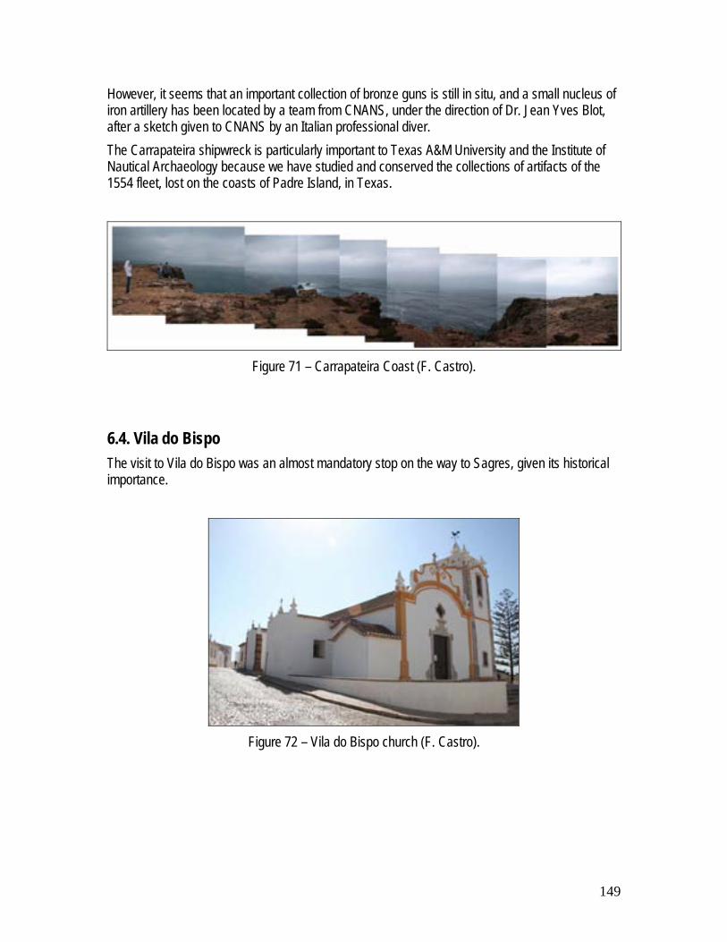
149
However, it seems that an important collection of bronze guns is still in situ, and a small nucleus of iron artillery has been located by a team from CNANS, under the direction of Dr. Jean Yves Blot, after a sketch given to CNANS by an Italian professional diver. The Carrapateira shipwreck is particularly important to Texas A&M University and the Institute of Nautical Archaeology because we have studied and conserved the collections of artifacts of the 1554 fleet, lost on the coasts of Padre Island, in Texas.
Figure 71 – Carrapateira Coast (F. Castro).
6.4. Vila do Bispo The visit to Vila do Bispo was an almost mandatory stop on the way to Sagres, given its historical importance.
Figure 72 – Vila do Bispo church (F. Castro).

150
6.5. Sagres The students have visited Sagres and the surrounding coast in the context of a long-term working relation planned by the municipality of Sagres and Texas A&M University. The nature of this promontory and a number of important shipwrecks historically recorded in the area make it a point of particular interest for the study of Portuguese seafaring history.
Figure 73 – Sagres fortress (F. Castro).
Figure 74 – Sagres promontory (after …).
6.6. Boca do Rio – Océan shipwreck site and potential Roman shipwreck site Boca do Rio is the site of a well-known archaeological complex dating to Roman times and excavated in the beginning of the 20th century. In the 18th century this site was occupied by a tuna fishing station. The area has been extremely eroded – at least 100 meters in the last century – and the river has almost disappeared under the sediments. The archaeological excavation of the French and Indian War French ship-of-the-line Océan, lost nearby on August 18 1759, were based at Boca do Rio and carried out by a team from Lisbon’s

151
Museu Nacional de Arqueologia, under the direction of Dr. Francisco Alves. These was the first underwater archaeology excavations in Portugal.
Figure 75 – Boca do Rio (F. Castro).
6.7. Zavial – Redoutable shipwreck site Another ship wrecked in 1759 on the coast of Algarve was the Redoutable, near the bay of Zavial. The team paid a short visit to the site.
Figure 76 – Zavial Beach (F. Castro).
6.8. Silves For its enormous archaeological importance, Silves was also visited by the Texas A&M University team. Being Sunday the archaeological museum was regrettably closed!

152
Figure 77 – Archaeological excavations inside Silves’ castle (F. Castro).
6.9. Margins of the Arade River After the visit to Silves the team visited the margins of the Arade River, arguably one of the most important archaeological areas in Portugal, are almost completely unexplored. Both the archaeological and historical records show that this region was inhabited since the Bronze Age.
Figure 78 – Arade River seen from Silves’ castle (F. Castro).
6.10. Portimão For its archaeological importance – in spite the fact that the bay has been dredged numerous times since the 1920s – Portimão was also visited, as well as the mouth of the Arade River.

153
Figure 79 – Portimão and the mouth of the Arade River (…)
6.11. Faro Faro was object of a special one day guided visit, lead by Tiago Fraga, which included visits to museums and several monuments.
Figure 80 – View of Faro (F. Castro)
6.12. Pedras del Rei In the 1990s a number of boats from the tuna fishing station that existed there were still visible in the dunes, together with a number of anchors from the tuna traps. The team made a visit to this beach in order to inspect the boats and anchors, as well as to visit the building, which were recovered and transformed into tourist facilities in the 1970s.

154
Figure 81 – Pedras del Rei (P. Creasman)
6.12.1. Tuna fisheries’ boats Only a small number of boats were visible and much destroyed. These were summarily recorded and photographed.
Figure 82 – Tuna fishing boats in the early 1990s (F. Castro)
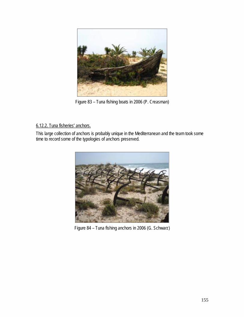
155
Figure 83 – Tuna fishing boats in 2006 (P. Creasman)
6.12.2. Tuna fisheries’ anchors. This large collection of anchors is probably unique in the Mediterranean and the team took some time to record some of the typologies of anchors preserved.
Figure 84 – Tuna fishing anchors in 2006 (G. Schwarz)

156
Appendix 7
Visit to Portimão’s new Archaeological Museum and Meeting with
Dr. José Gameiro

157
Introduction The third objective of the 2006 Summer school was to meet local people and Portuguese scholars, as well as to try to establish working relations that will hopefully provide future opportunities. The team met with Dr. José Gameiro, director of Museu de Arqueologia de Portimão, in the municipality immediately to the east of Lagos. After a lunch in which a number of projects were discussed and questions raised, Dr. José Gameiro showed us the future museum. Portimão municipality is a region with an extensive and precious cultural heritage that extends over several millennia and its Museum has a long held relation with nautical archaeology. In spite of the dredging works that it has endured over the last 80 years, the mouth of the Arade River remains a rich archaeological site and the Portimão Museum has sponsored and harbored many archaeological surveys and campaigns.
Figure 85 – Exhibition at the Museum of Portimão in 2002 (F. Castro).
In 1993 six bronze guns were recovered at the mouth of the Arade River, possibly from the shipwreck site of a Spanish ship lost on that spot in 1611 (Alves 1994). Throughout the 1990s GEO, a group of sport divers, has surveyed the area regularly and reported its finds, which have included one of the shipwrecks exposed in the 1970s by dredging works (Machado 2000; Alves et al., 1990; Alves et al. 1993; Alves 1999) Since 2001 the Centro Nacional de Arqueologia Náutica e Subaquática has conducted surveys and excavations (Castro 2002a; castro 2002b; Castro 2002c; Casatro 2005; Alves et al. 2005a; Alves et al. 2005b; Castro 2006).

158
Figure 86 – Three bronze guns from Ponta do Altar B (F. Castro)
Figure 87 – Museum of Portimão undergoing extensive works in 2006(F. Castro)

159
Figure 88 – Remodeling works inside the museum (F. Castro)
160
Appendix 8
Seminar

161
Introduction An advanced seminar was taught by Dr. Francisco Contente Domingues – Director of the Post-Graduation Studies in Portuguese Discoveries at the University of Lisbon – as part of the curriculum of the 2006 Summer School. Dr. Contente Domingues delivered a lecture about the historiography of the Portuguese Discoveries in relation to political and socio-cultural environments throughout the late 19th and 20th centuries, followed by a lecture on the ship types that were used in the Portuguese maritime expansion as described in historical documents, written and iconographic.
Figure 89 – Lecture by Dr. Contente Domingues (F. Castro)
Figure 90 – Audience (F. Castro)

162
Appendix 9
Conferences

163
Introduction A cycle of conferences delivered by the students was offered in the Municipal Library, aiming at the general public.
Figure 91 – First session of the seminar, by Dr. Rui Loureiro (P. Creasman).
This cycle of conferences was held in the municipal library every Friday evening, and encompassed a total of eight lectures.

164
Program
Nautical Archaeology Conferences – Lagos, Portugal. Day 1 (2 June): 19:00-20:25 Opening Session and The Discoveries and the Role of Lagos – 40 Minutes – Dr. Loureiro Break – 5 minutes Looking for the Missing Link: Survey Plans for the Lagos Area – 40 Minutes – T. Fraga Day 2 (9 June): 19:00-20:30 The Story of Iberian Vessels: Caravels What About Them? – 30 Minutes – G.Schwarz Break – 10 minutes
The Story of Iberian Vessels: The Pepper Wreck – 25 minutes – B. DuBard Day 3 (16 June): 19:00-20:30 The Story of Iberian Vessels: The Big Picture– 35 Minutes – Dr. Castro Break – 5 minutes
Iberian Timber During the Age of Discoveries – 35 minutes – P. Creasman Day 4 (23 June): 19:00-20:30 Iberian Treatises, Nautical Archaeology Digital Library and the Dick Steffy Database 25 minutes – S. Koepnick Break – 10 minutes
‘Photomodelor:’ Its Use and Application in Archaeology – 25 minutes – A. Catsambis Day 5 (30 June): 19:00-20:30
Patrimonio e Turismo – 30 minutes – T. Fraga Break – 10 minutes Os itenerarios subaquaticos – 35 minutes – P. Caleja Round Table and Closing Session – 20 minutes
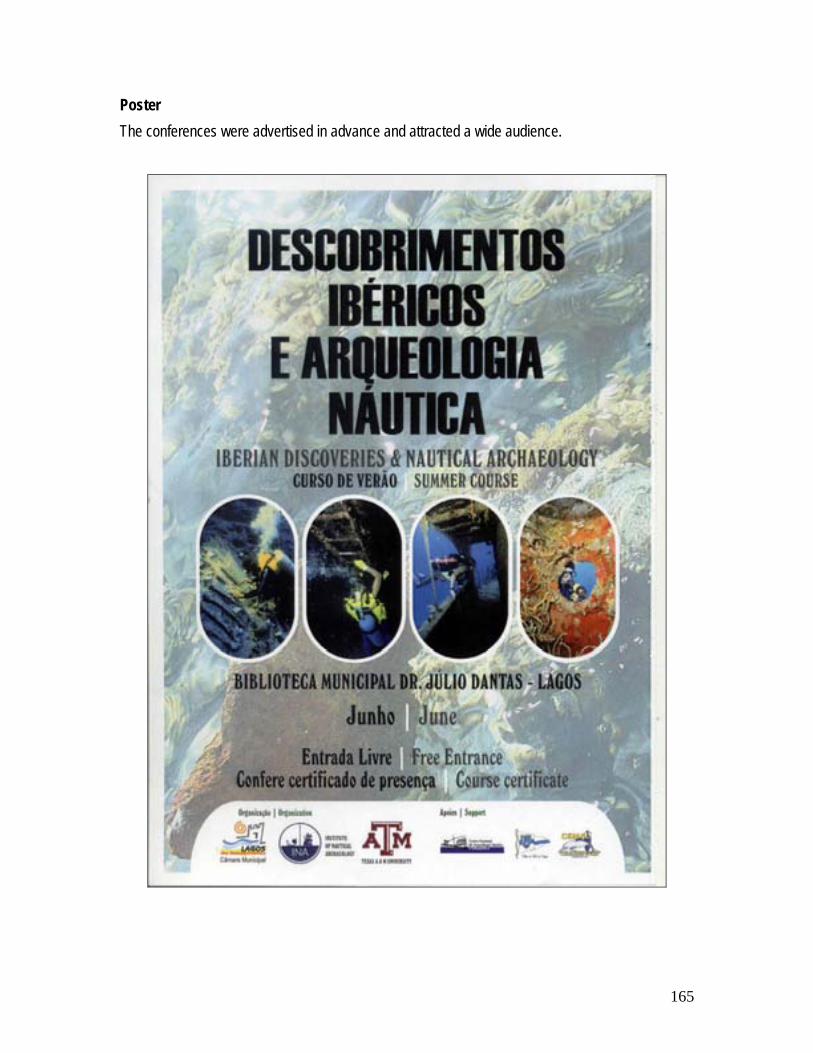
165
Poster The conferences were advertised in advance and attracted a wide audience.


![Recent advances in developing 2 orbital-free kinetic … [27] and the Vosko, Wilk, and Nusair (VWN) approximation for correlation [28]). Then, for those geometries and densities, we](https://static.fdocuments.us/doc/165x107/5cada3c588c993b30b8e044f/recent-advances-in-developing-2-orbital-free-kinetic-27-and-the-vosko-wilk-and.jpg)


