Khada Valley Development Plan
25
INTERNAL. This information is accessible to ADB Management and staff. It may be shared outside ADB with appropriate permission. Khada Valley Development Plan A. Background 1. The Government of Georgia, with financing support from the Asian Development Bank (ADB) and the European Bank for Reconstruction and Development (EBRD) has commenced the construction of a new highway between Kvesheti and Kobi (the project), two towns on the North-South Corridor that passes through Gudauri. The new and existing alignments are shown in Figure 1 below, in orange and white respectively. Figure 1: Project Area and New Highway 2. The new highway will be constructed to international standards and will include 5 tunnels, including the longest in Georgia, several major bridges, one of which will be the highest in Georgia. The new highway is expected to be completed by late 2024. The executing agency for the project is the Ministry of Regional Development and Infrastructure (MRDI) and the implementing agency is the Roads Department of Georgia (RD). 3. The project area is located at 1320m-1975 m above sea level. The new alignment passes through the Khada Valley, at present a largely rural area with no all-weather road access and a small population spread across 13 villages with limited infrastructure. 1 The population of the Khada Valley has declined by 32% since 2002. The valley contains a significant number of sites of cultural heritage value, and its upper part is located in the vicinity of the Kazbegi National Park. A description of the project area is in Annex 1. 4. Documentation describing the project and its preparation can be found on ADB’s website and the project’s dedicated website. 2 A list of reference documents is in Annex 2. These documents include comprehensive technical, economic, environmental, and social impact assessments and action plans, and several other briefs, studies, and reports. 1 About 695 people live in road adjacent villages for part of the year (2019 estimates), of which about 277 people live in the valley proper while the rest of the population lives in Kvesheti (199), Arakveti (212) and Kobi (7). 2 https://www.adb.org/projects/51257-001/main#project-documents and https://kveshetikobiroad.ge/en/
Transcript of Khada Valley Development Plan
INTERNAL. This information is accessible to ADB Management and staff. It may be shared outside ADB with appropriate permission.
Khada Valley Development Plan
A. Background
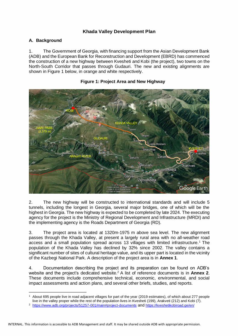
1. The Government of Georgia, with financing support from the Asian Development Bank (ADB) and the European Bank for Reconstruction and Development (EBRD) has commenced the construction of a new highway between Kvesheti and Kobi (the project), two towns on the North-South Corridor that passes through Gudauri. The new and existing alignments are shown in Figure 1 below, in orange and white respectively.
Figure 1: Project Area and New Highway
2. The new highway will be constructed to international standards and will include 5 tunnels, including the longest in Georgia, several major bridges, one of which will be the highest in Georgia. The new highway is expected to be completed by late 2024. The executing agency for the project is the Ministry of Regional Development and Infrastructure (MRDI) and the implementing agency is the Roads Department of Georgia (RD). 3. The project area is located at 1320m-1975 m above sea level. The new alignment passes through the Khada Valley, at present a largely rural area with no all-weather road access and a small population spread across 13 villages with limited infrastructure.1 The population of the Khada Valley has declined by 32% since 2002. The valley contains a significant number of sites of cultural heritage value, and its upper part is located in the vicinity of the Kazbegi National Park. A description of the project area is in Annex 1. 4. Documentation describing the project and its preparation can be found on ADB’s website and the project’s dedicated website.2 A list of reference documents is in Annex 2. These documents include comprehensive technical, economic, environmental, and social impact assessments and action plans, and several other briefs, studies, and reports.
1 About 695 people live in road adjacent villages for part of the year (2019 estimates), of which about 277 people live in the valley proper while the rest of the population lives in Kvesheti (199), Arakveti (212) and Kobi (7). 2 https://www.adb.org/projects/51257-001/main#project-documents and https://kveshetikobiroad.ge/en/

INTERNAL. This information is accessible to ADB Management and staff. It may be shared outside ADB with appropriate permission.
5. The project area currently faces a number of challenges including the (i) absence of an integrated vision for development; (ii) lack of basic infrastructure and services; (iii) inadequate registration of land plots; (iv) poor demarcation between buildable and non-buildable areas; (v) traffic disruption due to weather conditions; and (vi) lack of touristic infrastructure and facilities. A community needs assessment was prepared by an independent consultant and revealed a number of immediate needs (infrastructure and social services) and development aspirations (ecotourism, ski resort, agriculture, etc.)3. 6. The new highway will change the valley that is currently remote and largely abandoned during winter. Recognizing these challenges, the government and ADB have agreed to develop a comprehensive development framework for the Khada Valley, which will include a Historic-Cultural Reference Plan (being developed under a separate contract; scheduled for completion in February 2022) and a Development Plan as defined the Law of Georgia on Spatial Planning, Architectural and Construction Activities (“the Code”).4 This development framework will be consistent with the government’s Strategy for Development of High Mountain Settlements.
7. This Terms of Reference (TOR) defines the activities required to prepare Khada Valley Development Plan (KVDP) considering the construction of the new highway between Kvesheti and Kobi.. The purpose of the KVDP is to preserve the valley from unwanted and uncontrolled
development while maximizing immediate benefits and future opportunities for local communities
B. Objective
8. The KVDP will seek the preservation of the Khada Valley and include (i) a Development Plan that will be prepared in accordance with Georgia’s Laws and Regulations and contain all details necessary for the issuance of building permits for the defined construction zones and functional sub-zones;5 and (ii) a Priority Investment Plan that will serve as a guiding framework to identify, select, and prioritize sustainable projects that are suitable for government and/or private financing. Through the KVDP, ADB and EBRD will help the government in finding a balance between community development aspirations, regional development, and local conservation goals. 9. The KVDP will follow best international practices while ensuring alignment with national legislation and strategies, relevant international conventions Georgia is signatory to, and ADB/EBRD’s policies. It will foster participatory and inclusive planning, pay specific attention to nature-based and cultural heritage values, and provide an implementation framework for the long-term development of the valley. 10. Two different approaches will be followed when planning the development of the Khada Valley and its surroundings. Further to the KDVP preparation, (1) the 9 villages located within the Khada Valley and bordering the existing Gudauri recreation area will eventually be integrated to the Gudauri Recreational Plan once it will be updated;6 and (2) a separate development regulation plan will be prepared for the other 3 villages (Bedoni, Kvesheti, and
3 Community needs assessment report can be found on the project website; web-site address is provided in the
annex 5). 4 The team for the preparation of the Historic-Cultural Reference Plan includes the following experts: geographer, urban planner/architect, cultural heritage specialist, archeologist, environment specialist, history/ethnography specialist, landscape architect, social specialist, and GIS specialist. 5 The Law of Georgia on Spatial Planning, Architectural and Construction Activities and Resolution No 260 of the Government of Georgia of 3 June 2019 on the Rules of Spatial Planning and Urban Development Plans. 6 These include: Zakatkari, Tsikhiani, Sharmiani, Sviana-Rostiani, Korogho, Iukho, Benian-Begoni, Mughure,
Tskere.

INTERNAL. This information is accessible to ADB Management and staff. It may be shared outside ADB with appropriate permission.
Arakhveti) due to their location, which will be further incorporated by Dusheti Municipality under its planning documents (Figure 2). C. Scope of the Assignment
11. The scope of this assignment includes the development of two plans: Khada Valley
Development Plan (Task 1) and Priority Investment Plan (Task 2).
12. A Khada Valley Development Plan, focusing on spatial and land-use issues, in
accordance with the Code and Resolution N260 of the Government of Georgia of 3 June 3
2019 on the Rule of Spatial Planning and Urban Development Plans. The Khada Valley and
its surroundings will be treated as two separate planning units (para. 10) and the KVDP will
include two parts (sub-plans). Part 1 will cover the development regulation plan for the 9
villages located in Khadistskali gorge within the boundaries of the Gudauri Recreation Area.
Part 2 will cover the development regulation plan for 3 villages located along the confluence
of the rivers Mtiuleti, Aragvi and Khadistskali (Figure 2), which are outside of the boundaries
of Gudauri Recreation Area7. The survey area marked in Figure 2 should be divided into two
parts according to the boundaries of Gudauri Recreation Area. The boundary between these
two development regulation plans should be defined considering the boundaries of the
Gudauri Recreation Area.
13. A Priority Investment Plan, presenting short-, medium- and longer-term capital and
operational expenditures at the municipal/community level and also through appropriate
private sector involvement. Specific objectives of this Plan will be to preserve the valley and
limit impacts on its cultural heritage, assist valley residents with adapting to the changes the
project will bring, and provide for the needs and impacts of the increased populations and
likely commercial pressures that will ensue. The PlP will include a list of priority sustainable
projects that will be considered for implementation in conjunction with the highway opening.
Task 1 – Khada Valley Development Plan (KVDP) The main tasks of the Consultant will include, but not limited to, the following:
• In consultation with MRDI and other relevant agencies, locate and collate as many as
possible of the relevant studies of the project area, including its physical, social,
environmental, and cultural aspects. Summarize takeaways from these studies into a
GIS including a compendium of thematic and analytical maps, alternatively referred to
as an Atlas, which is accessible, searchable and able to be updated through standard
web browser applications.
• Develop the KVDP in compliance with the planning principles set out in Article 8 of the
Code as well as relevant Laws and Regulations (Annex 2). The KVDP must contain
all the details necessary for the issuance of a building permit. The KVDP will also
include a Strategic Environment Assessment (SEA) as defined by the Code, which will
be informed by existing studies, public hearings, and consultations.
• In line with international good practices, the KVDP will foster a participatory and
inclusive planning approach and pay specific attention to nature-based and cultural
heritage values including mapping of biodiversity high-value areas.
7 These include: Bedoni, Arakhveti and Kvesheti.

INTERNAL. This information is accessible to ADB Management and staff. It may be shared outside ADB with appropriate permission.
• Follow a stepwise approach to develop the KVDP in accordance with the Code. These steps, outlined in Annex 4, should include the following: (i) collect data and define a planning unit; (ii) carry out fieldwork and analyze data; (iii) formulate a vision and strategy; (iv) develop a Concept Plan; (v) prepare the Development Plan; and (vi) set-up an Information System.
• Consider the indicative planning unit boundaries in Figure 2 below and recommend boundaries for the KVDP, which should be supported by a detailed analysis along with robust data. Provide a detailed description and justification for the recommended planning boundaries. Take into consideration the existing Gudauri Recreational Masterplan, the forthcoming Kazbegi Spatial Territorial Plan and the Historic-Cultural Reference Plan for the Khada Valley.
• Consider seasonality and complementarity with Gudauri as a determining factor in the development of the valley. While today, the valley is largely inaccessible during winter (usually between November and April), the highway will open new opportunities during winter. Engage with the tourism and business community to explore the type of activities that could be developed in the valley throughout the year (e.g.: skiing and adventurous sports).
• Consider cultural heritage protection zones recommended in the Historic-Cultural Reference Plan and propose ways to reduce overall landscape impacts in the valley in the short-, medium- and long-term.
• Prepare a Stakeholder Engagement Plan, which will guide the KVDP preparation and foster participatory and inclusive planning. Stakeholder groups may include local population (including youth, women and elderly groups with disabilities), local and regional authorities, private sector, Ministry of Finance, MRDI, line ministries, academia, CSOs, and project lenders. Build on the community needs assessment (Footnote 3) and carry out focus group discussions including separate discussions with women and vulnerable groups (elderly, persons with disabilities) to ascertain and refine these needs and aspirations while examining their feasibility and sustainability vis-à-vis the government’s strategies and priorities.
• Drawing from the KVDP vision and recommendations from stakeholders, prepare a Branding and Marketing plan to position the branding of the valley and help build up its reputation over time. This will also inform the Priority Investment Plan in Task 2.
• Prepare an implementation arrangement outline for the KVDP, consisting with relevant laws and regulations, setting out a results framework, responsibilities, staffing, resources, and other matters needed to ensure that the Plan can be implemented as intended.
• Finalize the KVDP and prepare it for approval in accordance the Code’s provisions.

INTERNAL. This information is accessible to ADB Management and staff. It may be shared outside ADB with appropriate permission.
Figure 2: Indicative Planning Boundaries
Task 2 – Priority Investment Plan (PIP) The main tasks of the Consultant will include, but not limited to, the following:
• Review the output of community consultations related to communities’ views of the project, its impacts, and how their interests, and aspirations could be addressed. Identify specific needs, concerns and aspirations of women and vulnerable groups. Build on this work and ascertain and refine community needs and aspirations while examining their feasibility and sustainability vis-à-vis the government’s strategies and priorities.
• Undertake additional consultations and surveys, including with potential private sector organizations that might be interested in investing in appropriate facilities and activities in the project area.
• Develop a set of criteria to select sustainable projects and carry out a multicriteria analysis to prioritize and program projects over time. Criteria should include, but not limited to, economic, social/community, financial, environmental, and landscape considerations. The projects should be aligned with the government’s Strategy for Development of High Mountain Settlements.
• In line with the KVDP, prepare a plan of priority investments that could be implanted in the short term (2024), and in the medium (2027) and longer term (2032). Responsibilities and estimated recurrent expenditures such as staffing and training and operation and maintenance of facilities, should also be included in the plan.

INTERNAL. This information is accessible to ADB Management and staff. It may be shared outside ADB with appropriate permission.
• Include possible implementation arrangements for specific activities, possibly including government agency involvement and support, community participation, NGO involvement, private sector investments, and others as appropriate.
• Undertake a rapid assessment of the economic viability and financial sustainability of the proposed investments and select priority projects that could possibly be implemented as part of the ongoing project civil works activities or other MRDI-supported projects.
• Prepare a concept design (including landscape considerations) for the selected priority projects that would be suitable for project costing and TOR for detailed engineering design.
• Provide suitable maps, plans, presentations, and other suitable graphical approaches to facilitate understanding of the activities and investments being proposed.
• Submit the draft PIP to the Working Group (Section D) for its review and comments. Discuss and finalize the draft PIP with relevant authorities (MRDI, Dusheti and Kazbegi municipalities).
14. The Consultant will closely coordinate the work with the government counterparts
primarily with the Spatial Planning Department and Roads Department of the MRDI,
ADB/EBRD, local communities, and relevant CSOs to provide updates and flag any issues to
be resolved.
D. Implementation Arrangements
15. The assignment will be financed by ADB through a technical assistance grant and
carried out by a national consulting firm engaged by ADB in accordance with its policies and
procedures. The Consultant will be selected from national firms (with support from
international experts) that have relevant experience with preparing Development Plans in
accordance with the requirements defined above.
16. The Consultant will be based in Tbilisi with team members travelling to and remaining
within the project area for the durations required to effectively carry out the assignment.
17. A Monitoring Group (“Group”) will be created in coordination with MRDI and will consist
of representatives from RD and Spatial Planning Department of MRDI, Dusheti and Kazbegi
municipalities, and ADB/EBRD representatives. The functions of the Group will be to (i) ensure
smooth communication and information sharing between group members; (ii) receive monthly
progress updates from the Consultant; and (iii) provide timely support to the Consultant on
access to project relevant data as necessary.
18. As part of the review process, the Consultant shall submit the draft reports (Section F)
to ADB and the Spatial Planning Department of MRDI as well as to all members of the Group
and incorporate their comments during the finalization of the reports. These comments and
inputs will be summarized in a comments matrix and shared with the Group members for their
information and deliberation as may be appropriate. Workshops will also be held with the
Group on an as needed basis and upon request of its members. Workshops will help seek
inputs from other stakeholders (including the National Agency for Cultural Heritage
Preservation of Georgia) as defined in Section C.

INTERNAL. This information is accessible to ADB Management and staff. It may be shared outside ADB with appropriate permission.
E. Team Composition
19. An indicative consultant team composition and staff inputs is Table 1 below. Consulting
firms proposing for the assignment may adjust the composition to suit their approach to
meeting the requirements set out in these TOR, subject to not significantly exceeding the total
consultant person-month inputs.
20. Consulting firms may also associate with other firms or individual consultants to
provide the complete range of expertise required for the assignment. Position-specific
requirements are provided in Annex 3. Consultants proposing for the assignment will be
required to submit curricula vitae (CVs) for each of these positions with their proposal.
Table 1: Indicative Team Composition and Estimated Inputs
Position Person-months 1 Urban Planner/Team Leader 10
2 Geographer 5 3 International Regional Planner 3
4 International Landscape Architect 4
5 Biodiversity/Environment Specialist 4 6 Tourism Specialist 4
7 Agriculture/Livestock Specialist 4 8 Small and Medium-sized Enterprises Specialist 3
9 Economist/Financial Specialist 3 10 Transport/Mobility Specialist 3
11 Infrastructure Engineer 3 12 Branding/Marketing Specialist 3
13 Social Development/Community Specialist 4 14 GIS Specialist 9
15 Translator – Georgian/English. 8 16 Head office support 3
Total 73 Note: All the positions are National apart from the Regional Planner and Landscape Architect.
F. Deliverables and Time Schedule
21. The assignment is to be completed within 12 months of the selected consultant being
issued with a Notice to Proceed (NTP). When preparing their implementation schedules,
consultants are to consider the effect of winter weather conditions on sensitive activities, for
example field investigations and surveys and community consultations. The reports are to be
delivered following the milestones in Table 2.
Table 2: Deliverables, Milestones and Payment Schedule
Report
Milestone
Payment Schedule (% of contract amount)
Mobilization -- 10%
Inception Month 1 10% First Interim Month 4 15%
Second Interim Month 6 15% Draft Final Month 9 20%
Final Month 11 30%

INTERNAL. This information is accessible to ADB Management and staff. It may be shared outside ADB with appropriate permission.
22. Inception Report. This report will include:
(i) a Stakeholder Engagement Plan outlining groups to be consulted, when and how;
(ii) a gap analysis and data collection/survey program;
(iii) a first draft SWOT analysis and possible development directions;
(iv) draft planning boundaries for the Development Plan;
(v) revisions to the assignment schedule if required, within the overall assignment period, changes to personnel inputs if any, problems encountered and suggested remedies, and other initial matters as appropriate.
23. First Interim Report. This report will include:
(i) Planning boundaries for the Development Plan;
(ii) a refined SWOT analysis;
(iii) a Vision and Strategy as defined by the Code;
(iv) a Draft Concept Plan as defined by the Code;
(v) a Scoping for Strategic Environmental Assessment Report (SEA) as defined by the Code;
(vi) a draft database and GIS architecture;
(vii) a summary of stakeholder engagement activities.
24. Second Interim Report. This report will include:
(i) a Concept Plan as defined by the Code;
(ii) an assessment of development scenarios;
(iii) a draft SEA;
(iv) a draft compendium of analytical and thematic maps (also referred to as an Atlas);
(v) a summary of stakeholder engagement activities;
25. Draft Final Report. This report will include:
(i) a draft Development Plan as defined by the Code;
(ii) a draft Information System ad defined by the Code;
(iii) a SEA as defined by the Code;
(iv) a draft Branding/Marketing Plan;
(v) a draft Priority Investment Plan;
(vi) a summary of stakeholder engagement activities.
26. Final Report. This report will include:
(i) a Development Plan as defined by the Code;
(ii) an Information System as defined by the Code;
(iii) a Priority Investment Plan;
(iv) a Branding/Marketing Plan;
(v) a compendium of analytical and thematic maps;
(vi) Stakeholder Engagement Summary Report.

INTERNAL. This information is accessible to ADB Management and staff. It may be shared outside ADB with appropriate permission.
27. All the above outputs are to be submitted to the RD and Spatial Planning Department
of MRDI and to ADB in digital and paper form in Georgian and English languages. The reports
should include maps, drawings, and other graphical material. The Consultant and ADB will
agree on a suitable format and outline report prior to submission of the reports. Digital
submission will be by large file transfer application agreed with Spatial Planning Department
of MRDI supplemented by CDs as appropriate. Paper submission will be 2 copies to each
agency mentioned above and 1 copy to ADB. Details regarding format of documents are in
Annex 5.
G. Data, Local Services, Personnel, and Facilities to be provided by the MRDI
28. MRDI will identify the core team to work with the Consultant to facilitate the access to available data sources on the subject project area. H. Minimum Qualification requirements:
29. The firm shall demonstrate: (i) preferably 7 years of experience in direction of spatial and urban planning; (ii) preferably 5 years of experience in preparation of development regulation
planning documents, preferably in high mountainous areas; (iii) preferably 3 years of experience of conducting surveys in historical urban
settlements; (iv) experience of working with international organizations will be and advantage.
I. Annexes
- Annex 1: Project Area Description - Annex 2: List of Reference Documents - Annex 3: Position-based TORs - Annex 4: Outline Description of Development Preparation - Annex 5: Formats of Documents
INTERNAL. This information is accessible to ADB Management and staff. It may be shared outside ADB with appropriate permission.
Annex 1: Project Area Description
Location and Physical Characteristics
Dusheti municipality is mountainous, with elevations ranging from 870 to 4000 meters above
sea level, and therefore the climatic conditions are very diverse. The climate in the lower
zone is moderately humid, with mild winters and long warm summers. The average annual
temperature in the lowlands (870-899 m) is 9.7°C. Precipitation levels are approximately 750
mm per annum. In the highland areas the climate is more humid, precipitation increases and
ranges from 1,200 to 1,600 mm.
Three main geomorphological types can be distinguished, depending on the location and the
amount of precipitation. Slope formations of various scales are common. Topographically,
glacial and periglacial forms and formations occur in the upper belts, while the lower belts are
represented by alluvial sediments.
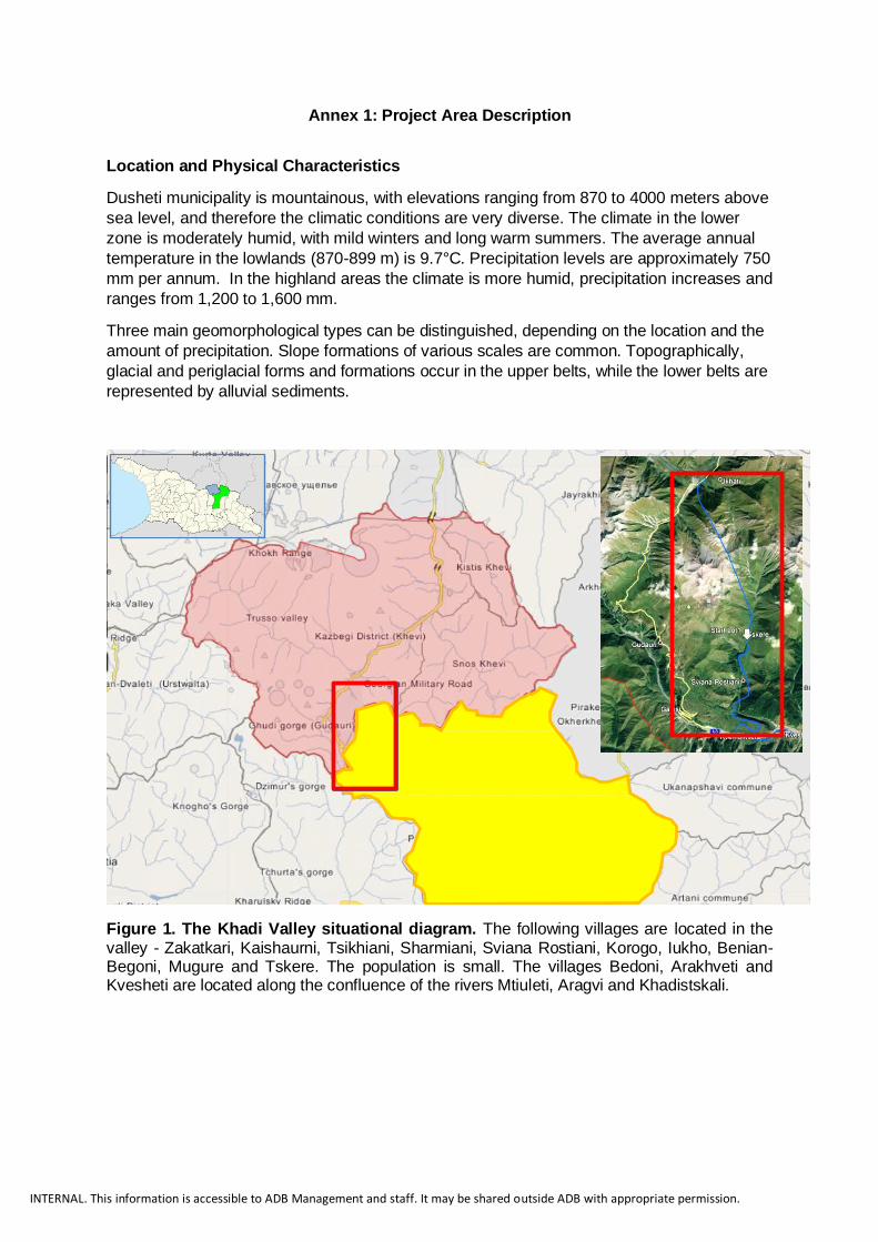
Figure 1. The Khadi Valley situational diagram. The following villages are located in the valley - Zakatkari, Kaishaurni, Tsikhiani, Sharmiani, Sviana Rostiani, Korogo, Iukho, Benian-Begoni, Mugure and Tskere. The population is small. The villages Bedoni, Arakhveti and Kvesheti are located along the confluence of the rivers Mtiuleti, Aragvi and Khadistskali.
INTERNAL. This information is accessible to ADB Management and staff. It may be shared outside ADB with appropriate permission.
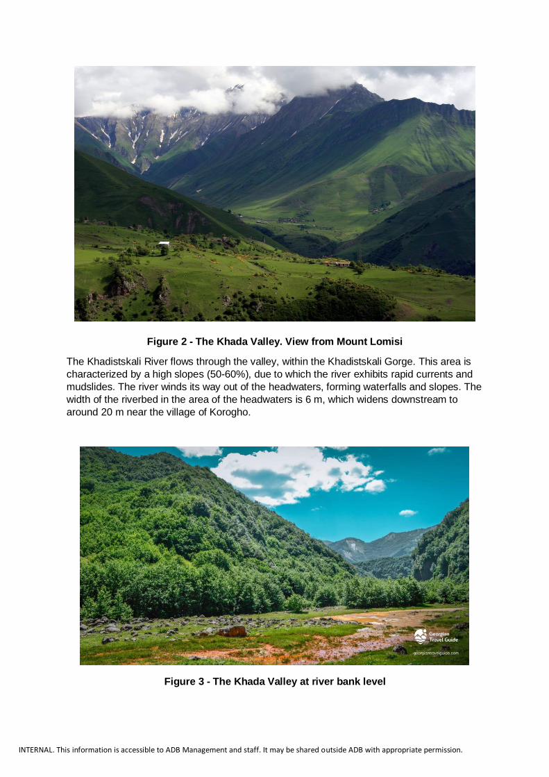
Figure 2 - The Khada Valley. View from Mount Lomisi
The Khadistskali River flows through the valley, within the Khadistskali Gorge. This area is
characterized by a high slopes (50-60%), due to which the river exhibits rapid currents and
mudslides. The river winds its way out of the headwaters, forming waterfalls and slopes. The
width of the riverbed in the area of the headwaters is 6 m, which widens downstream to
around 20 m near the village of Korogho.
Figure 3 - The Khada Valley at river bank level

INTERNAL. This information is accessible to ADB Management and staff. It may be shared outside ADB with appropriate permission.
Historical and Cultural Context According to the local definition, the name "Khada" means a mountain, a mountainous place.
It is suggested that its old name is Tsilkani. According to Vakhushti Bagrationi (XVIII century),
Khada is the same as Tsikara ("a rocky place with 60 towers"). The Khada valley has been
inhabited since the Neolithic period. In the Middle Ages, Khada was predominantly an integral
part of the Aragvi Saeristavo. In the early 13th century, the Khada population fought against
the rebellious inhabitants of Didoeti and Pkhkovi to protect Queen Tamar's power. At the end
of the 13th century, Khada became the target of Mongol raids. During the Mtiuleti uprising
(1804), the first clashes with government troops took place in the village of Kaishaurni (now
Dusheti municipality) in the valley. Reflecting this long history, the valley is characterized by
an abundance of medieval monuments. There are many monuments in the valley - castles,
castle towers, chapels, old cemeteries and stones with inscriptions, some of which are
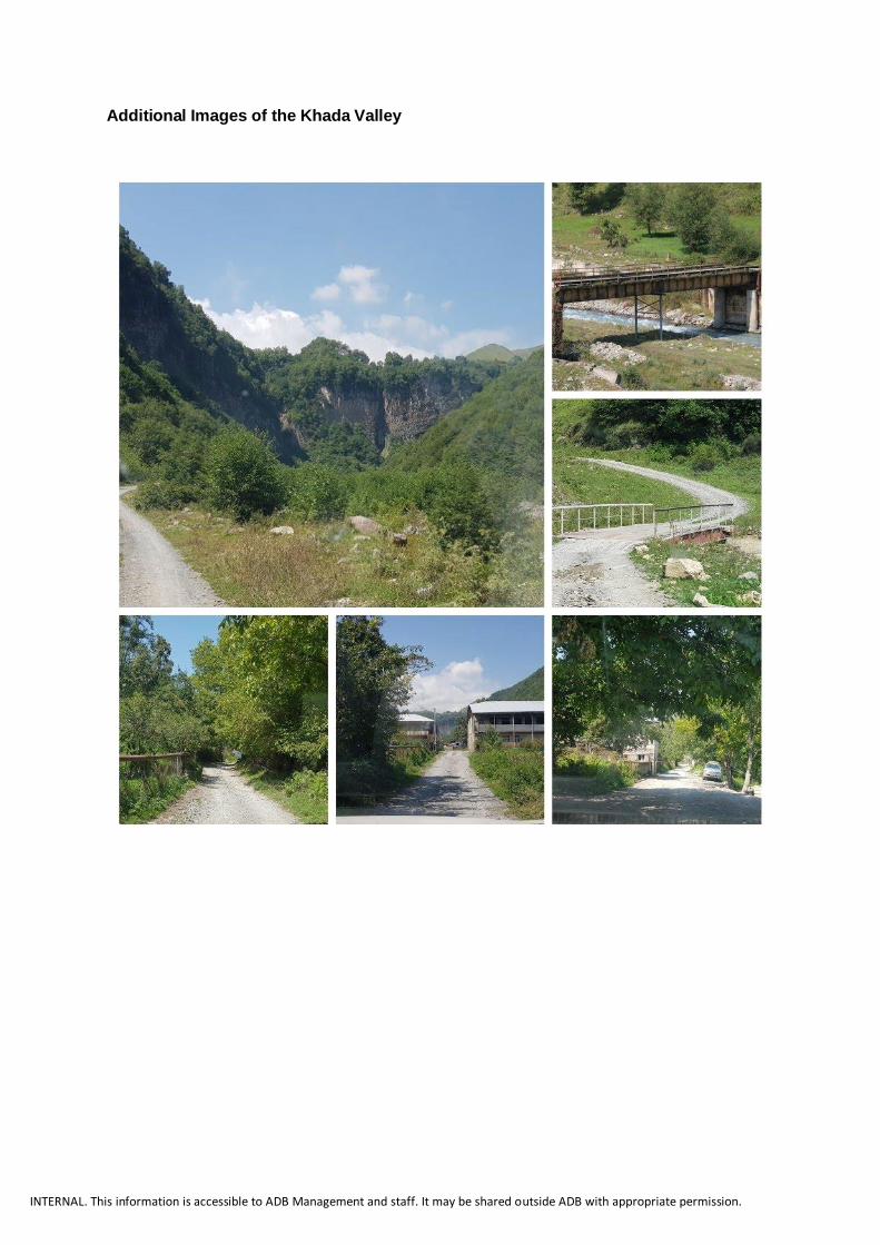
presented in the images below.
INTERNAL. This information is accessible to ADB Management and staff. It may be shared outside ADB with appropriate permission.
Additional Images of the Khada Valley

INTERNAL. This information is accessible to ADB Management and staff. It may be shared outside ADB with appropriate permission.

INTERNAL. This information is accessible to ADB Management and staff. It may be shared outside ADB with appropriate permission.

INTERNAL. This information is accessible to ADB Management and staff. It may be shared outside ADB with appropriate permission.
Annex 2: List of Reference Documents
1. Guidance Documents
Examples of both normative-legal and best practices in Georgia should be used in planning.
The following are mandatory guidelines for use in the development plan elaboration process:
1.2. Studies and Reports
ADB website:https://www.adb.org/projects/51257-001/main#project-documents Project website: https://kveshetikobiroad.ge/en/
Normative Description
Constitutional Law Constitution of Georgia Organic Law Code of Local Self-Government
Law Code on Spatial Planning, Architectural and Construction Activities of Georgia
Law On Environmental Protection
Law On Cultural Heritage Law On Development of Mountainous Regions
Law Code of ecological evaluation Law On Water
Law Forest Code Law On the Protected Area System
Law On Highways.
Law On Traffic Jams. Law On Civil Security
Law On Tourism and Resorts
Law Waste Management Code
Law On Geodesic and Cartographic Activities
Law On State Secrets Presidential Decree On the System of State Geodesic Coordinates in Georgia
Government Resolution
On the Basic Provisions on the Use and Development of Territories
Government Resolution
On the Rules of Territorial Planning and Urban Development Plans
Government Resolution
On Protection of Georgian Surface Waters from Pollution
Government Resolution
Technical regulation - construction climatology
Other Description
Spatial Planning A key tool for effective governance and development, with particular emphasis on countries with economies in transition (Author: UN, European Economic Commission; New York and Geneva 2008)
New Global Agenda for a Sustainable Future
Document adopted by the 17th Session of the UN General Assembly: "Transforming Our World: A 2030 Agenda for Sustainable Development"
State Program Action Plan of the Government of Georgia for 2019-2020

INTERNAL. This information is accessible to ADB Management and staff. It may be shared outside ADB with appropriate permission.
Annex 3: Position Based TORs
1. Team Leader: This role will be fulfilled by the Urban Planner He/She shall demonstrate substantial experience in leading multidisciplinary team and addressing various and cross-cutting spatial planning issues. He/She shall demonstrate a good understanding of administration of projects and contracts. He/She will be the focal point for the Client.
2. Urban Planner: Professionally qualified urban planner (at least Bachelor or equivalent) with preferably 15 years of experience in spatial planning in Georgia. He/She will be responsible for assembling all inputs from the team and putting together the KVDP and PIP. In addition, he/she will work closely with the International Regional Planner to incorporate best international practices.
3. Geographer: Professionally qualified urban planner (at least Bachelor or equivalent) with
preferably 15 years of experience in spatial planning in Georgia. He/She will be responsible for assembling all inputs from the team and putting together the KVDP and PIP. In addition, he/she will be leading the preparation of the Atlas and provide day-to-day guidance to the GIS Specialist.
4. Regional Planner (International): Professionally qualified regional planner (at least
Bachelor or equivalent) with preferably 15 years of experience in regional planning in similar context (e.g. highway in rural areas, mountainous regions, cultural heritage/biodiversity hotspots…). He/She will provide the team with international insights and best practices. He/She will also provide inputs to the PIP and the Branding/Marketing Plan.
5. Landscape Architect (International): Professionally qualified landscape architect (at least
Bachelor or equivalent) with preferably 15 years of experience in landscape planning in similar context (e.g. highway in rural areas, mountainous regions, cultural heritage/biodiversity hotspots…). He/She will provide the team with international insights and best practices. He/She will also prepare concept designs for the selected priority projects under the PIP and look at ways to further reduce impacts through the development of planting plans and green infrastructure.
6. Biodiversity/Environment Specialist: Professionally qualified environmentalist (at least
Bachelor or equivalent) with preferably 10 years of experience in environment planning in biodiversity-sensitive projects in Georgia. He/She will be responsible for providing biodiversity/environment inputs to the KVDP and PIP. In addition, he/she will be leading the preparation of the Strategic Environmental Impact Assessment.
7. Tourism Specialist: Professionally qualified environmentalist (at least Bachelor or equivalent) with preferably 10 years of experience in tourism development in Georgia. He/She will be responsible for providing tourism-related inputs to the KVDP and PIP. In addition, he/she will work closely with the SME specialist to propose concrete tourism projects that can improve people’s livelihoods.
8. Agriculture/Livestock Specialist: Professionally qualified environmentalist (at least
Bachelor or equivalent) with preferably 10 years of experience in agriculture and livestock development in Georgia. He/She will be responsible for providing agriculture-and livestock-related inputs to the KVDP and PIP. In addition, he/she will work closely with the SME specialist to propose concrete agriculture/livestock projects that can improve people’s livelihoods.
INTERNAL. This information is accessible to ADB Management and staff. It may be shared outside ADB with appropriate permission.
9. Small and Medium-sized Enterprises Specialist: Professionally qualified business expert (at least Bachelor or equivalent) with preferably 10 years of experience in SME development in Georgia. He/She will be responsible for providing business development inputs to the KVDP and PIP. In addition, he/she will assess the business potential in the project area and prepare a detailed action plan to stimulate SME development, which will be fed into the PIP.
10. Economist/Financial Specialist: Professionally qualified economist or financial specialist
(at least Bachelor or equivalent) with preferably 10 years of experience in economic and financial analysis of projects in Georgia. He/She will be responsible for providing economic/financial-related inputs to the KVDP and PIP. In addition, he/she will carry out economic and financial analysis for all investments identified under the PIP.
11. Transport/Mobility Specialist: Professionally qualified transport specialist (at least
Bachelor or equivalent) with preferably 10 years of experience in transport and mobility planning in Georgia. He/She will be responsible for providing transport and mobility-related inputs to the KVDP and PIP. In addition, he/she will work closely with the infrastructure engineer to propose concrete local transportation projects and/or services that can improve people’s livelihoods.
12. Infrastructure engineer: Professionally qualified infrastructure engineer (at least
Bachelor or equivalent) with preferably 10 years of experience in infrastructure engineering in Georgia. He/She will be responsible for providing engineering-related inputs to the KVDP and PIP. In addition, he/she will prepare cost estimates for the selected priority projects under the PIP.
13. Branding/Marketing Specialist: Professionally qualified marketing expert (at least
Bachelor or equivalent) with preferably 10 years of experience in marketing and branding development in Georgia. He/She will be responsible for providing marketing-related inputs to the KVDP and PIP. In addition, he/she will be leading the preparation of the Branding/Marketing Plan.
14. Social Development/Community Specialist: Professionally qualified social expert (at
least Bachelor or equivalent) with preferably 10 years of experience in social development and community mobilization in Georgia. He/She will be responsible for providing social-related inputs to the KVDP and PIP. In addition, he/she will be leading the preparation and implementation of the Stakeholder Engagement Plan.
15. GIS Specialist: Professionally qualified GIS expert (at least Bachelor or equivalent) with
preferably 10 years of experience in GIS development in Georgia. He/She will be responsible for providing GIS-related inputs to the KVDP and PIP. In addition, he/she will be leading the preparation of the Information System for the KVDP.
16. Translator (Georgian/English): Qualified professional with preferably 5 years of
experience in providing Georgian/English translation services (written and oral) for activities similar to those of the assignment, including meetings with high-level officials.
17. Head office Support: The Consultant is responsible to determine and provide in its
proposal additional non-key experts who may be necessary to deliver the outputs described in Section F of the TOR.

INTERNAL. This information is accessible to ADB Management and staff. It may be shared outside ADB with appropriate permission.
Annex 4: Outline Description of Development Preparation
30. Data collection. Primary data about the situation within the designated planning unit must be collected in-house in accordance with the rules of plan development. Given the hierarchy and variety of data, the data must be properly systematized. The collection and analysis of baseline data should be thematic, taking into account sectoral affiliation. It is possible to divide the entire designated unit into constituent balancing units (in this case, settlements/villages).8 If necessary, the latter, depending on the scale, can be divided into development management units (microdistrict, district). At the same time, the development unit should be considered as a unit with detailed development plans. A development plan for such units should be developed with the details required for issuing a construction permit, and/or the area should be designated for a further/detailed development plan. 31. Fieldwork and data analysis. Based on the assessment of the baseline data, fieldwork should be carried out which, on the one hand, will focus on verifying the information and guidelines/ recommendations presented in the study and, on the other hand, on collecting unavailable data that are important for planning. Upon completion of the fieldwork, the data obtained (referenced) should be thoroughly verified and the analysis of the results obtained should be completed. Work and analysis of results should be carried out in accordance with the requirements of the Code. The information obtained about the current condition of the designed unit should be processed using GIS technologies. 32. Vision and strategy. The vision should state the strategic development goals, which will lead to a series of results-oriented actions to be performed over a period of time, the effectiveness of which will be measured through key indicators. Strategic goals are hierarchical and should be sorted according to priorities. In line with international best practices, the vision should follow these principles: (i) Brevity: easy to remember and repeat; (ii) Clarity: defines the main/strategic goal(s) of development; (iii) Time-bound: defines a timeline that describes the goal(s) to be achieved; (iv) Future-oriented: describes a developed future rather than a present moment or process; (v) Stability: the vision should anticipate to the extent possible market and/or technology volatility; (vi) Challenging: should include ambitious goals and supporting measures; and (vii) Annotative: the general text should be sufficient to express the common interests and strategic goals of stakeholders. The strategy requires the sequencing of land use and the development of their construction potential, taking into account the priorities that will eventually be agreed with all stakeholders. In prioritizing, it is necessary to subdivide the designed unit provided for in this assignment into balancing and development management units (in this case, settlements). 33. Spatial Concept Plan. Based on the information gathered and analyzed in the previous step, a coherent development vision and strategy must be developed for both the spatial development of the designed unit and the management of the development. This will help to answer the question - "What kind of designed unit do we see in the future?" The key here is a realistic approach and possibility of meeting goals. For this purpose, it is recommended to set medium-term goals. It is necessary to develop a vision of optimal scale, based on realistic objectives, with a high probability of realization. The SWOT method should be used to assess the vision and objectives through their strengths, weaknesses, opportunities, and threats. Key stakeholders should be actively involved in the process of shaping the development vision and strategy. Given the agreed vision and development strategy, specific
8 It is not about the administrative-territorial units of the municipality, but about the internal division of the settlement.

INTERNAL. This information is accessible to ADB Management and staff. It may be shared outside ADB with appropriate permission.
solutions should be formulated in the Spatial Concept Plan. This can be reflected in the outline of the development regulations, which will specify the parameters defined in this task. 34. Information system. The purpose of the information system is to create the most complete and objective information database for spatial planning and urban planning, which is maintained at the country and municipality levels, and can be based on various information databases in this area. The information system should include at least:
• Data on spatial development policy and / or development management regulations;
• Social, transport, engineering and agricultural infrastructure data;
• Data on the location and condition of buildings;
• Ecological, engineering-geological and seismic status data of the areas; and
• Other data used to develop planning documentation, spatial development and/or development management.

INTERNAL. This information is accessible to ADB Management and staff. It may be shared outside ADB with appropriate permission.
Annex 5: Formats of Documents
1. Form and Specifics of Document Submission
1.2. Form
The album is made in print and electronic form. For the initial submission of the report prepared at each stage of the service, the form of submission can only be electronic. Unless the Customer requests the submission of individual parts in tangible form. Final reports are required in both forms.
• Printed album 3 copies;
• In electronic format (PDF) as a CD-ROM - 5 copies; and
• Electronic version of geoinformation systems materials on DVD - 5 copies.
The printed album should be prepared by printing it on appropriately sized paper and binding it accordingly. The software for preparing (assembling, formatting, and/or downloading) the electronic form album can be any and final presentation format - PDF, unless the specific assignment requires the use of a specific software and file format. The use of the file protection mechanism is not allowed without the customer's consent. The electronic form is sent on CD(s) and/or memory card(s). Especially large files can be submitted using a cloud-based database.
1.2.1. Specifics
The main information of the report (the contents of the album) should be presented in the textual and graphic sections (maps, plans and/or other cartographic material). In turn, the textual section may include illustrations (photos, graphs, small schematic drawings, etc.).
The established format of the paper text is A4. It is allowed to use tabs of A3 format (illustrations, schemes). The format of the tabulated part of the graphical section is determined by this assignment. The graphic section must have a stamp, which must indicate: used symbols, details of the project, the name of the work and responsible for their implementation specialists.
All pages in the album, except the title page, should be numbered, the main text should be typed in 11 "Sylfaen" font, auxiliary text - at least in size 8 of the same font. Line spacing -1.0. The text margin on the page of the text section is 2.54 cm (left) and 1.5 cm on the right.
Non-cartographic diagrams of the graphic section may not meet the requirements set by the plans for the basic map but should provide sufficient information for reading them. The following mandatory requirements must be considered when distributing information on the tablet part of the graphic section:
• The main drawing is placed in the central part, from the left or upper edge to the stamp;
• The stamp, with relevant information, should be placed on the right side as a vertical bar or on the right side as a horizontal bar;
• The base drawing may have an outline frame; and
• The annotation should not cover the base drawing and the base text should not be scattered over the drawing.
The entire album must be certified by the specialists in charge of the report from the planning team (material document - personal signature, and electronic document - qualified electronic signature).

INTERNAL. This information is accessible to ADB Management and staff. It may be shared outside ADB with appropriate permission.
Given the above, the album should have:
1. Cover - where the following is indicated: Title of the document; Title of the Project; Name of
2. the designed unit; Essence of the work done (summary); Date and place. 3. Title page(s) - where the details of the contract and the stage of work under which the
document was prepared are given; Details of the customer and contractor; Persons responsible for the document; Information about the state agency(ies), municipal authorities and/or interested stakeholders concerned.
4. Competency page - which provides information: on the qualifications of the performers of the document.
5. Summary - a brief description of the work done and the relationship to the current task and the implementer's own action plan.
6. Definition of terms (only terms other than Code) and explanation of abbreviations (if any).
7. Table of contents - where the contents of the album are given in accordance with the sections of the development plan and their arrangement on the pages. The table of contents should include chapters and subsections, optionally paragraphs and passages. It is advisable that the table of contents is "active", i.e., related to the text.
8. Basic text - the main text should be executed with appropriate formatting and a standard structure.
9. References - a list of bibliographic references and/or references in the text using ISO 690 (an ISO standard that governs bibliographic references in various documents, including electronic documents).
10. Annexes - where, if available, graphics, related documents/sources, or other materials are given to justify the basic text.
Any statistical and factual information presented in the documents must be accompanied by a full reference to the relevant official source, including the pages. In the case of electronic format with a reference to the relevant links. Likewise, documented interviews and meetings: in the form of minutes and photographs.
Even in the absence and/or inaccessibility of valuable information for research and/or planning, results must be displayed and only follow the appropriate instructions, including the explanation(s) that led to the outcome.
2. Formats of maps
The DP basic plan must qualitatively meet the requirements set out in the plan development method. The format of the basic plan should be determined according to the scale of the recommendation and may be non-standard.
The dimensions of the basic mapping format shall be in accordance with the range given in Annex N3 to the Plan Development Rule, in accordance with the DP detalization. The digital part of the baseline maps should be integrated into the design information system.

INTERNAL. This information is accessible to ADB Management and staff. It may be shared outside ADB with appropriate permission.
Based on the baseline maps, at least the following thematic maps / plans should be prepared separately:
Section Contents Specifications
Situation map / plan
Spatial context of the planned object
The basis of the drawing is an orthophoto, observing all its features.
The necessary elements of the projection:
• The design object (dotted line); and
• Landmarks that define the location (major landmarks and/or roads).
Boundary map / plan
Design object boundaries
The basis of the drawing is a topographic map / plan (according to the level of research), observing all its characteristics.
Given the level of research, the essential elements of projection are:
• Municipality boundary
• Designed unit boundaries;
• Boundaries of built-up and undeveloped areas of settlements; and
• Boundaries of balance units for which data collection/analysis has been conducted and further planning needs to be introduced; Places of interest (social infrastructure, culture and recreation, religious and cultural, administrative, etc.)
Physical environment map/plan
The basis of the figure is a map / plan of the borders with all its features, including the protected zones of cultural heritage. Taking into account the taxonomic level, the necessary elements of the projection are:
• Buildings, including cultural heritage sites and inappropriate facilities; o Functional purpose; o Floor number; o Physical condition; o Age; o Construction grade; o Architectural and artistic value (valuable objects
are singled out); o Existing urban and natural spatial dominants; o Points of perception of important panoramas;
• The network of transport infrastructure with all its characteristics observed;
• The network of technical infrastructure, respecting all its characteristics;
• Boundaries of green areas, water bodies and natural values;
• Boundaries of areas with natural and technogenic hazards, taking into account geological-seismic and climatic-environmental data; and
• Places of interest (social infrastructure; culture and recreation; religious and cultural; sports, administrative, etc.).

INTERNAL. This information is accessible to ADB Management and staff. It may be shared outside ADB with appropriate permission.
Table 1. Thematic Mapping Matrix 2.1 GIS, database format, structure and support software In accordance with legal requirements, the standard cadastral structure must include supporting information layers, permit issuance management layers, and planned development layers.
The cadastral software is ArcGIS 10 or other compatible alternative (preferably with a free license).The minimum technical requirements for the geographic information material to be provided are as follows:
• Geo-information materials should be created and processed in ArcGIS 10 version
personal geodatabase format; and
• Personal geodatabase should be in WGS 84 \ UTM 38N Georgian state coordination
system.
The final version of the geo-information materials (meaning certain layers) should be checked
for topological errors (topological accuracy 0.025 m).
• Development management regulations shall be affixed to the main drawing, at the edges in such a way as not to cover the designed unit. If necessary, the drawing on the back of the text is covered with a white background. The basic requirements will be displayed on the tablet and the full text should be displayed in the text section.
Sectoral areas, the development of which is based on the common tasks of the relevant taxonomic level of planning, and it is impossible to present them properly in an integrated way.
Legal environment map / plan
The drawing is based on a boundary map/plan and a cadastral map, observing all their characteristics:
Necessary elements of the projection are:
• Data from the state register on land plots in the area, for the relevant stage of the project, according to the form of ownership (state, municipal, private, etc.);
• Information on regulations and boundaries of the established regimes;
• Boundaries of the current spatial planning documents;
• Statistical data, taking into account all its characteristics; and
• Results of the survey on the expression of interest and involvement

INTERNAL. This information is accessible to ADB Management and staff. It may be shared outside ADB with appropriate permission.