Keynote - National Oceanic and Atmospheric Administration · Keynote Dru Smith NSRS Modernization...
26
Keynote Dru Smith NSRS Modernization Manager Daniel R. Roman Spatial Reference System Division Chief NOAA’s National Geodetic Survey
Transcript of Keynote - National Oceanic and Atmospheric Administration · Keynote Dru Smith NSRS Modernization...

Keynote
Dru Smith NSRS Modernization Manager
Daniel R. Roman
Spatial Reference System Division Chief
NOAA’s National Geodetic Survey

Why are we here?
• Of course: • To learn • To exchange information • To get out of the office for a week
• But why are we here (as in “near NGS headquarters”)? • The new vertical datum and its cornerstone:
• GRAV-D
May 23, 2016 2

The new vertical datum
• 2007 – NGS formally declares an end-of-life date for NAVD 88 – Only sustainable way forward: geoid-based datum – Biggest hurdle: terrestrial gravity data
• Heterogeneous in about every way – Instruments, Dates, Observers, Spacing, Metadata
• Old • Huge voids in littoral regions
May 23, 2016 3

Within-survey Errors
May 23, 2016 4

Across-surveys Errors
May 23, 2016 5
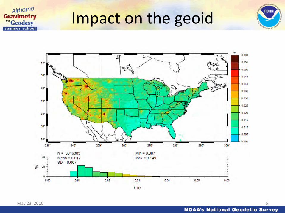
Impact on the geoid
May 23, 2016 6

Ship gravity
Terrestrial gravity
New Orleans
20-100 km gravity gaps along coast
Airborne gravity is the only technique that can adequately connect existing terrestrial data to existing ship and altimetry data in the oceans and fill coverage gaps. Airborne data will not replace existing data, but will be used as a baseline for correcting that data to be consistent across the country.
Terrestrial Data before GRAV-D
May 23, 2016 7

May 23, 2016
Approximate extent of 2022 geoid model used for the “North American” part of the new vertical datum
8

Historical geoid accuracy…or not
• From Geodesy (Bomford, 1952, section 6.00): – “For geodetic purposes, an error of 1 mGal matters little…”
• From Physical Geodesy (Heiskanen and Moritz, 1967, section 2.16): – “…an error of probably less than 1 meter in N, which can be neglected
for most practical purposes…”
• These issues are related! If you can’t get accurate gravity, you can’t get an accurate geoid. – Gravimeter accuracy and geoid accuracy march forward together – Geoid theory must also advance (but that is the other IAG summer
school!)
May 23, 2016 9

A very brief history of gravimetry
• 1670s-1680s: Discovery that gravity varied geographically – Came out of clock measurements
• Relation between pendulum periods and gravity
– Accuracy Problem: Ideal pendulums (point mass
attached to a massless swing arm) swing differently than true pendulums
May 23, 2016 10

A very brief history of gravimetry
• 1817: Kater reversible pendulum – Pendulum hung normally, then
upside down
– Exploits results of 1673 paper by Huygens
May 23, 2016 11

A very brief history of gravimetry
• 1960s: Three absolute techniques vying for dominance (see Cook, 1968): – Kater pendulums still in use (~ 150 years!) – Ballistic meters – Freefall meters
• Calibrated rods, corner cubes, slotted rods • Lasers playing an ever-increasing role
• Accuracies at 0.1 mGal and improving
May 23, 2016 12

Shipborne Gravimetry
• 1920s-1950s – Initiated by Vening-Meinesz – Submarines (to avoid weather) with pendulums
• 1930s on: – Multiple techniques for surface ships
• Spring-based dominated • Some pendulum • Vibrating string accelerometer
May 23, 2016 13

Airborne Gravimetry
• We’ll save this for Dr. Jekeli’s lectures…
• Suffice to say, by the 1990s, the practice of airborne gravimetry had still not sufficiently advanced to use the data in most geoid modeling
May 23, 2016 14
Gravimetry and the Geoid at NGS
• NGS holds 2 million terrestrial (including shipborne) gravity measurements – Many thanks to NGA’s efforts
• Geoids have been made at NGS with this data
since 1990 – With ever-increasing accuracy
• But you can only massage bad data into good geoids for so long
May 23, 2016 15
Proving the accuracy of a geoid based on airborne gravity:
Geoid Slope Validation Surveys
May 23, 2016 16

“...the gravimetric geoid used in defining the future vertical datum of the United States should have an absolute accuracy of 1 centimeter at any place and at any time.”
-- The NGS 10 year plan (2008-2018)*
Admirable!...Achievable?
May 23, 2016
Proving Geoid Accuracy
* Latest 10 year plan runs 2013-2023, but does not change this basic goal
17

Goal of the surveys
• Observe geoid shape (slope) using multiple independent terrestrial survey methods – GPS + Leveling – Deflections of the Vertical
• Compare observed slopes (from terrestrial surveys) to modeled slopes (from gravimetry or satellites) – With / Without new GRAV-D airborne gravity
May 23, 2016 18

GSVS11
May 23, 2016
325 km 218 points 1.5 km spacing
South Texas July-October, 2011 hot…Hot…HOT!
19

Surveys Performed
• GPS: 20 identical. units, 10/day leapfrog, 40 hrs ea.
• Leveling: 1st order, class II, digital barcode leveling
• Gravity: FG-5 and A-10 anchors, 4 L/R in 2 teams
• DoV: ETH Zurich DIADEM GPS & camera system
• LIDAR: Riegl Q680i-D, 2 pt/m2 spacing, 0.5 km width
• Imagery: Applanix 439 RGB DualCam, 5000’ AGL
• Other: – RTN, short-session GPS, extra gravity marks around Austin, gravity
gradients May 23, 2016 20

May 23, 2016
GPS DoV
Leveling
Gravity
LIDAR/ Imagery
21

Empirical Error Estimates
May 23, 2016
• σ∆h (OPUS-S) : 2 - 6 cm – GPSCOM combination: ~ 4 mm – (no significant baseline dependency)
• => 16 mm RMS over GSVS11
• σξ , ση : 0.06 arcseconds
– ~ 0.43 mm / 1.5 km => 6.6 mm RMS over GSVS11
22

GSVS11: Proving why we need GRAV-D
May 23, 2016
Geoids without new GRAV-D data: 1-3 cm differential accuracy over distances from 0.4 to 325 km
Geoids with new GRAV-D data: 1 cm differential accuracy over distances from 0.4 to 325 km
23

GSVS11 Conclusions
• For GSVS11, adding airborne gravity data improves geoid slope accuracy at all distances <325 km • Low elevation, flat topography
• Gravimetric geoid models and GPS are a viable alternative to long-line leveling
• Paper: Confirming regional 1 cm differential geoid accuracy from airborne gravimetry: the Geoid Slope Validation Survey of 2011
– J Geod DOI 10.1007/s00190-013-0653-0
May 23, 2016 24

More GSVSs
• GSVS14: Took place in Iowa – Results less dramatically improved – Likely due to reasonableness of terrestrial data in
the center of the continent
• GSVS17: Southern Colorado – Marks being installed this year
May 23, 2016 25

Thank you!
May 23, 2016 26