KEY GLADES SLOPE SAFETY SKI WITH CARE - sugarloaf.com Maps/burntmtn... · national ski patrol and...
2
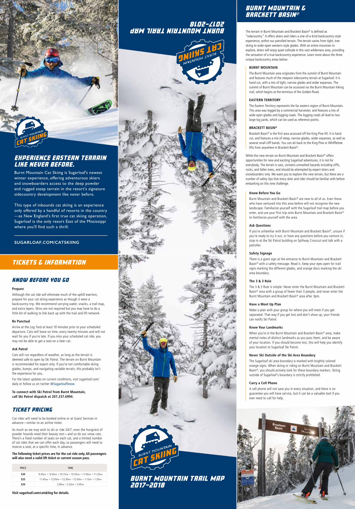
NATALIE’S BIRCHES NATALIE’S BIRCHES K I N G P I N E KING PINE S K I D W A Y SKIDWAY S A W D U S T E R SAWDUSTER W H I F F L E T R E E WHIFFLETREE S N U B B E R SNUBBER M O O S E C A L A T O R MOOSECALATOR D O U B L E R U N N E R E A S T DOUBLE RUNNER EAST D O U B L E R U N N E R W E S T DOUBLE RUNNER WEST S U G A R L O A F S U P E R Q U A D SUGARLOAF SUPERQUAD LOWER LOG YARD LOWER LOG YARD SUMMIT 3,595' UPPER LOG YARD UPPER LOG YARD BRACKETT BASIN ® BURNT MOUNTAIN EASTERN TERRITORY BRACKETT BASIN ® BURNT MOUNTAIN EASTERN TERRITORY SUGARLOAF MOUNTAIN SUGARLOAF MOUNTAIN MEET CAT HERE ENTER HERE 1. Always stay in control and be able to stop or avoid other people or objects. 2. People ahead of you have the right of way. It is your responsibility to avoid them. 3. You must not stop where you obstruct a trail, or are not visible from above. 4. Whenever starting downhill or merging into a trail, look uphill and yield to others. 5. Always use devices to help prevent runaway equipment. 6. Observe all posted signs and warnings. Keep off closed trails and out of closed areas. Snowfields are considered part of the trail system. 7. Prior to using any lift, you must have the knowledge and ability to load, ride and unload safely. 8. It’s a big mountain. Don’t ski alone, especially on your last run. The mountain is not patrolled after the lifts close. This is a partial list. Be safety conscious. Officially endorsed by NATIONAL SKI AREAS ASSOCIATION, NATIONAL SKI PATROL AND PROFESSIONAL SKI INSTRUCTORS OF AMERICA. FIRST AID FACILITY The First Aid Facility is located at the R.H. Bell Interfaith Chapel off the Birches Slope. Skiing can be enjoyed in many ways. At ski areas you may see people using alpine, snowboard, telemark, cross-country or other specialized ski equipment, such as that used by disabled or other skiers. Regardless of how you decide to enjoy the slopes, always show courtesy to others and be aware that there are elements of risk in skiing and riding that common sense and personal awareness can help reduce. Observe the code listed below and share with other skiers the responsibility for a great skiing experience. KNOW THE CODE. IT’S YOUR RESPONSIBILITY. BE ADVISED THAT ALL FENCING, EQUIPMENT COVERS, POLES, SIGNAGE AND OTHER MARKING DEVICES ARE IN PLACE TO INFORM YOU AND TO INDICATE A POTENTIAL HAZARD OR OBSTACLE. THESE MARKERS WILL NOT PROTECT YOU FROM INJURY. IT IS YOUR RESPONSIBILITY TO STAY AWAY FROM MARKED AREAS. SLOPE SAFETY SKI WITH CARE Alpine skiing and snowboarding are challenging and dangerous recreational activities in rough mountain forest terrain. Be alert to continually changing weather, visibility and surface conditions. Snow, ice, sheer drop-offs, bare ground, rocks, roots, stumps, trees, lift towers, ruts, bumps, snowmaking equipment, grooming vehicles, snowmobiles, other skiers, power poles and many other natural and man-made obstacles can cause permanent, catastrophic injury or death. Your safety is directly affected by your judgment. Failure to use good judgment, ski responsibly or follow Your Responsibility Code may result in the loss of skiing or snowboarding privileges. Snowmaking, grooming and ski area maintenance procedures and vehicles may be in operation at any time on open terrain. Do not ski or snowboard near such equipment. Skiing and snowboarding in Sugarloaf Mountain’s gladed terrain requires good judgment and personal awareness. Access in and out of these glades can be challenging. The gladed regions are vast and ski patrol’s ability to locate lost or injured patrons may be hindered by the scope of the terrain. All skiers and snowboarders are encouraged to enter the glades in groups of 3 or more and not travel alone. Most of this area is left in its natural state. It contains unmarked hazards including cliffs, rocks, fallen trees and avalanche hazards. Sugarloaf Mountain strictly forbids skiers and snowboarders from exiting the ski area boundaries and all signs and markers must be obeyed. Glades are for expert skiers and snowboarders only and all guests who enter these areas should be familiar with the trail map and ask questions to ski patrol before proceeding. Do not enter this area after 3:00 pm. 55 56 57 58 59 60 61 62 63 67 68 76 GOLDEN ROAD BIRLER GLADE 1 BIRLER GLADE 2 EDGER GLADE 1 EDGER GLADE 2 SWEEPER GLADE 1 SWEEPER GLADE 2 ROUGH CUT GLADE RED HORSE GLADE CANT DOG GLADE 1 CANT DOG GLADE 2 SLASH FIRE GLADE 65 64 66 78 79 75 BLACKSMITH GLADE HIGH BALL GLADE LOGGING ROAD ANDROSCOGGIN LITTLE ANDROSCOGGIN GLADE KENNEBEC GLADE EXPERTS ONLY (use extreme caution) MOST DIFFICULT MORE DIFFICULT EASIER KEY GLADES FIRST AID SKI AREA BOUNDARY GOLDEN ROAD BURNT MOUNTAIN TRAIL (some skier traffic between Kennebec Glade and Upper Log Yard) LOGGING ROAD CAT SKIING ROAD WHIFFLETREE EGRESS (some walking required) KING PINE X-CUT SNUBBER EGRESS (slower route; no walking required) DENOTES UNDEVELOPED TERRAIN DENOTES AREA ACCESSIBLE FROM CAT ACCESSIBLE FROM CAT NOT ACCESSIBLE FROM CAT
Transcript of KEY GLADES SLOPE SAFETY SKI WITH CARE - sugarloaf.com Maps/burntmtn... · national ski patrol and...

NATALIE’S BIRCHES
NATALIE’S BIRCHES
DESIGNATED UPHILL S K IN R
OUTE
DESIGNATED UPHILL S K IN R
OUTE
KING PINE
KING PINE
SKID
WAY
SKID
WAY
SAW
DUST
ER
SAW
DUST
ER
WHI
FFLE
TREE
WHI
FFLE
TREE
SNUBBER
SNUBBERMOOSECALATOR
MOOSECALATOR
DOUB
LE R
UNNE
R EA
ST
DOUB
LE R
UNNE
R EA
ST
DOUB
LE R
UNNE
R W
EST
DOUB
LE R
UNNE
R W
EST
SUGA
RLOA
F SUP
ERQU
AD
SUGA
RLOA
F SUP
ERQU
AD
LOWER LOG YARDLOWER LOG YARD
SUMMIT 3,595'
UPPER LOG YARDUPPER LOG YARD
BRACKETT BASIN®
BURNT MOUNTAIN
EASTERN TERRITORY
BRACKETT BASIN®
BURNT MOUNTAIN
EASTERN TERRITORY
SUGARLOAF MOUNTAINSUGARLOAF MOUNTAIN
MEET CAT HERE
ENTER HERE
1. Always stay in control and be able to stop or avoid other people or objects.
2. People ahead of you have the right of way. It is your responsibility to avoid them.
3. You must not stop where you obstruct a trail, or are not visible from above.
4. Whenever starting downhill or merging into a trail, look uphill and yield to others.
5. Always use devices to help prevent runaway equipment.
6. Observe all posted signs and warnings. Keep off closed trails and out of closed areas. Snowfields are considered part of the trail system.
7. Prior to using any lift, you must have the knowledge and ability to load, ride and unload safely.
8. It’s a big mountain. Don’t ski alone, especially on your last run. The mountain is not patrolled after the lifts close. This is a partial list. Be safety conscious. Officially endorsed by NATIONAL SKI AREAS ASSOCIATION, NATIONAL SKI PATROL AND PROFESSIONAL SKI INSTRUCTORS OF AMERICA.
FIRST AID FACILITY The First Aid Facility is located at the R.H. Bell Interfaith Chapel off the Birches Slope.
Skiing can be enjoyed in many ways. At ski areas you may see people using alpine, snowboard, telemark, cross-country or other specialized ski equipment, such as that used by disabled or other skiers. Regardless of how you decide to enjoy the slopes, always show courtesy to others and be aware that there are elements of risk in skiing and riding that common sense and personal awareness can help reduce. Observe the code listed below and share with other skiers the responsibility for a great skiing experience.
KNOW THE CODE. IT’S YOUR RESPONSIBILITY. BE ADVISED THAT ALL FENCING, EQUIPMENT COVERS, POLES, SIGNAGE AND OTHER MARKING DEVICES ARE IN PLACE TO INFORM YOU AND TO INDICATE A POTENTIAL HAZARD OR OBSTACLE. THESE MARKERS WILL NOT PROTECT YOU FROM INJURY. IT IS YOUR RESPONSIBILITY TO STAY AWAY FROM MARKED AREAS.
SLOPE SAFETY SKI WITH CARE
Alpine skiing and snowboarding are challenging and dangerous recreational activities in rough mountain forest terrain. Be alert to continually changing weather, visibility and surface conditions. Snow, ice, sheer drop-offs, bare ground, rocks, roots, stumps, trees, lift towers, ruts, bumps, snowmaking equipment, grooming vehicles, snowmobiles, other skiers, power poles and many other natural and man-made obstacles can cause permanent, catastrophic injury or death. Your safety is directly affected by your judgment. Failure to use good judgment, ski responsibly or follow Your Responsibility Code may result in the loss of skiing or snowboarding privileges. Snowmaking, grooming and ski area maintenance procedures and vehicles may be in operation at any time on open terrain. Do not ski or snowboard near such equipment.
Skiing and snowboarding in Sugarloaf Mountain’s gladed terrain requires good judgment and personal awareness. Access in and out of these glades can be challenging. The gladed regions are vast and ski patrol’s ability to locate lost or injured patrons may be hindered by the scope of the terrain. All skiers and snowboarders are encouraged to enter the glades in groups of 3 or more and not travel alone. Most of this area is left in its natural state. It contains unmarked hazards including cliffs, rocks, fallen trees and avalanche hazards. Sugarloaf Mountain strictly forbids skiers and snowboarders from exiting the ski area boundaries and all signs and markers must be obeyed. Glades are for expert skiers and snowboarders only and all guests who enter these areas should be familiar with the trail map and ask questions to ski patrol before proceeding. Do not enter this area after 3:00 pm.
55
56
57
58
59
60
61
62
63
67
68
76
GOLDEN ROAD
BIRLER GLADE 1
BIRLER GLADE 2
EDGER GLADE 1
EDGER GLADE 2
SWEEPER GLADE 1
SWEEPER GLADE 2
ROUGH CUT GLADE
RED HORSE GLADE
CANT DOG GLADE 1
CANT DOG GLADE 2
SLASH FIRE GLADE
65
64
66
78
79
75
BLACKSMITH GLADE
HIGH BALL GLADE
LOGGING ROAD
ANDROSCOGGIN
LITTLE ANDROSCOGGIN GLADE
KENNEBEC GLADE
EXPERTS ONLY (use extreme caution)
MOST DIFFICULT
MORE DIFFICULT
EASIER
KEY GLADES
FIRST AID
SKI AREA BOUNDARY
GOLDEN ROAD
BURNT MOUNTAIN TRAIL (some skier traffic between Kennebec Glade and Upper Log Yard)
LOGGING ROAD
CAT SKIING ROAD
WHIFFLETREE EGRESS (some walking required)
KING PINE X-CUT
SNUBBER EGRESS (slower route; no walking required)
DENOTES UNDEVELOPED TERRAIN
DENOTES AREA ACCESSIBLE FROM CAT ACCESSIBLE FROM CAT
NOT ACCESSIBLE FROM CAT
SUGARLOAF.COM/CATSKIING
EXPERIENCE EASTERN TERRAIN LIKE NEVER BEFORE.
BURNT MOUNTAIN TRAIL MAP 2017–2018BURNT MOUNTAIN TRAIL MAP 2017–2018
TICKETS & INFORMATION
KNOW BEFORE YOU GO
Prepare Although the cat ride will eliminate much of the uphill exertion, prepare for your cat skiing experience as though it were a backcountry trip. We recommend carrying water, snacks, a trail map, and extra layers. Skins are not required but you may have to do a little bit of walking to link back up with the trail and lift network.
Be Punctual
Arrive at the Log Yard at least 10 minutes prior to your scheduled departure. Cats will leave on time, every twenty minutes and will not wait for you if you're late. If you miss your scheduled cat ride, you may not be able to get a seat on a later cat.
Ask Patrol
Cats will run regardless of weather, as long as the terrain is deemed safe to open by Ski Patrol. The terrain on Burnt Mountain is recommended for expert only. If you're not comfortable skiing glades, bumps, and navigating variable terrain, this probably isn't the experience for you.
For the latest updates on current conditions, visit sugarloaf.com/daily or follow us on twitter @SugarloafSnow.
To connect with Ski Patrol from Burnt Mountain, call Ski Patrol dispatch at 207.237.6994.
TICKET PRICING
The terrain in Burnt Mountain and Brackett Basin® is defined as “sidecountry.” It offers skiers and riders a one-of-a-kind backcountry-style experience, within our patrolled terrain. The terrain varies from tight, tree skiing to wide-open western-style glades. With an entire mountain to explore, skiers will enjoy quiet solitude in this vast wilderness area, providing the sensation of a true backcountry experience. Learn more about the three unique backcountry areas below:
BURNT MOUNTAIN
The Burnt Mountain area originates from the summit of Burnt Mountain and features much of the steepest sidecountry terrain at Sugarloaf. It is hand cut, with a mix of tight, narrow glades and wider expanses. The summit of Burnt Mountain can be accessed via the Burnt Mountain hiking trail, which begins at the terminus of the Golden Road.
EASTERN TERRITORY
The Eastern Territory represents the far eastern region of Burnt Mountain. This area was logged by a commercial harvester, and features a mix of wide open glades and logging roads. The logging roads all lead to two large log yards, which can be used as reference points.
BRACKETT BASIN®
Brackett Basin® is the first area accessed off the King Pine lift. It is hand cut, and features a mix of steep, narrow glades, wider expanses, as well as several small cliff bands. You can ski back to the King Pine or Whiffletree lifts from anywhere in Brackett Basin®.
While this new terrain on Burnt Mountain and Brackett Basin® offers opportunities for new and exciting Sugarloaf adventures, it is not for everybody. The terrain is vast, contains unmarked hazards including cliffs, rocks, and fallen trees, and should be attempted by expert skiers and snowboarders only. We want you to explore this new terrain, but there are a number of safety tips that every skier and rider should be familiar with before embarking on this new challenge.
Cat rides will need to be booked online or at Guest Services in advance—similar to an airline ticket.
As much as we may wish to ski or ride 24/7, even the hungriest of powder hounds need their beauty rest—and so do our snow cats. There’s a fixed number of seats on each cat, and a limited number of cat rides that we can offer each day, so passengers will need to reserve a seat, at a specific time, in advance.
The following ticket prices are for the cat ride only. All passengers will also need a valid lift ticket or current season pass.
Visit sugarloaf.com/catskiing for details.
Burnt Mountain Cat Skiing is Sugarloaf's newest winter experience, offering adventurous skiers and snowboarders access to the deep powder and rugged steep terrain in the resort's signature sidecountry development like never before.
This type of inbounds cat skiing is an experience only offered by a handful of resorts in the country —as New England's first true cat skiing operation, Sugarloaf is the only resort East of the Mississippi where you'll find such a thrill.
BURNT MOUNTAIN & BRACKETT BASIN®
PRICE TIME
$30 9:30am • 9:50am • 10:15am • 10:35am • 11:00am • 11:20am
$25 11:45am • 12:05pm • 12:30pm • 12:50pm • 1:15pm • 1:35pm
$20 2:00pm • 2:20pm • 2:45pm
Know Before You Go
Burnt Mountain and Brackett Basin® are new to all of us. Even those who have ventured into this area before will not recognize the new landscape. Familiarize yourself with the Sugarloaf trail map before you enter, and use your first trip onto Burnt Mountain and Brackett Basin® to familiarize yourself with the area.
Ask Questions
If you're unfamiliar with Burnt Mountain and Brackett Basin®, unsure if you're ready to try it out, or have any questions before you venture in, stop in at the Ski Patrol building on Spillway Crosscut and talk with a patroller.
Safety Signage
There is a giant sign at the entrance to Burnt Mountain and Brackett Basin® with a safety message. Read it. Keep your eyes open for trail signs marking the different glades, and orange discs marking the ski area boundary.
The 3 & 3 Rule
The 3 & 3 Rule is simple: Never enter the Burnt Mountain and Brackett Basin® area with a group of fewer than 3 people, and never enter the Burnt Mountain and Brackett Basin® area after 3pm.
Have a Meet Up Plan
Make a plan with your group for where you will meet if you get separated. That way if you get lost and don't show up, your friends can notify Ski Patrol.
Know Your Landmarks
When you're in the Burnt Mountain and Brackett Basin® area, make mental notes of distinct landmarks as you pass them, and be aware of your location. If you should become lost, this will help you identify your location to Sugarloaf Ski Patrol.
Never Ski Outside of the Ski Area Boundary
The Sugarloaf ski area boundary is marked with brightly colored orange signs. When skiing or riding on Burnt Mountain and Brackett Basin®, you should actively look for these boundary markers. Skiing outside of Sugarloaf's boundary is strictly prohibited.
Carry a Cell Phone
A cell phone will not save you in every situation, and there is no guarantee you will have service, but it can be a valuable tool if you ever need to call for help.