KENT MINERALS AND WASTE LOCAL PLAN
49
KENT MINERALS AND WASTE LOCAL PLAN STRATEGIC FLOOD RISK ASSESSMENT ON BEHALF OF KENT COUNTY COUNCIL June 2013
Transcript of KENT MINERALS AND WASTE LOCAL PLAN

KENT MINERALS AND WASTE LOCAL PLAN
STRATEGIC FLOOD RISK ASSESSMENT
ON BEHALF OF
KENT COUNTY COUNCIL
June 2013
KENT MINERALS AND WASTE LOCAL PLAN
STRATEGIC FLOOD RISK ASSESSMENT
ON BEHALF OF
KENT COUNTY COUNCIL
JUNE 2013
Project Reference: 22198 22198
Status: Draft Final
Issue/Revision: 1 1
Date: 22/05/2013 10/06/2013
Prepared By: Katherine Dove Katherine Dove
Checked By: Simon Flisher Simon Flisher
Barton Willmore LLP The Observatory Southfleet Road Ebbsfleet Dartford Kent DA10 0DF Tel: (01322) 374660 Ref: 22198/A5/KD/mg/jp Fax: (01322) 374661 Date: June 2013 E-mail: [email protected] COPYRIGHT The contents of this document must not be copied or reproduced in whole or in part without the written consent of Barton Willmore LLP. All Barton Willmore stationery is produced using recycled or FSC paper and vegetable oil based inks
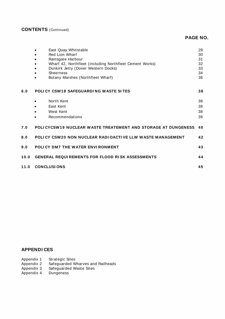
CONTENTS
PAGE NO.
1.0 INTRODUCTION 1 2.0 PLANNING POLICY CONTEXT 2
• National Planning Policy Framework 2 • National Planning Policy Framework Technical Guidance 2 • Groundwater Protection and Principles 3 • The Water Framework Directive 4 • Kent Preliminary Flood Risk Assessment (September 2011) 5 • Kent Draft Local Flood Risk Management Strategy (Dec 2012) 5 • Catchment Flood Management Plans 6 • Shoreline Management Plans 6 • Summary 6
3.0 SCOPE OF THE KENT MINERALS AND WASTE STRATEGIC FLOOD
RISK ASSESSMENT 8 • Types of flooding 8 • Flooding from Rivers 8 • Flooding from the Sea 9 • Flooding from Rainfall 9 • Flooding from Groundwater 9 • Source Protection Zones 9 • Flooding from Sewers 10 • Flood Zones and the Sequential Test 10 • Flood Zone 1 10 • Flood Zone 2 10 • Flood Zone 3 11 • Flood Zone 3b (the Functional Floodplain) 11 • Exception Test 13 • Climate Change 13
4.0 STRATEGIC SITES 14
• Medway Cement Works Holborough 14 • Norwood Quarry and Landfill 16 • Summary 17
5.0 SAFEGUARDED WHARVES AND RAILHEADS 18 • Allington Rail Sidings 18 • Sevington Rail Depot 19 • Hothfield Works 21 • East Peckham 22 • Ridham Dock (both operational sites) 23 • Johnson’s Wharf Greenhithe 24 • Robin’s Wharf Northfleet (both operations sites) 26 • Denton Marine Terminal 27
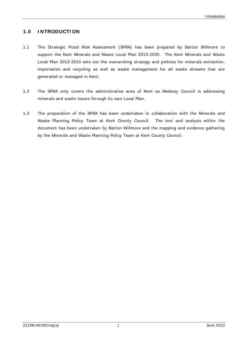
CONTENTS (Continued)
PAGE NO.
• East Quay Whitstable 28 • Red Lion Wharf 30 • Ramsgate Harbour 31 • Wharf 42, Northfleet (including Northfleet Cement Works) 32 • Dunkirk Jetty (Dover Western Docks) 33 • Sheerness 34 • Botany Marshes (Northfleet Wharf) 36
6.0 POLICY CSW18 SAFEGUARDING WASTE SITES 38 • North Kent 38 • East Kent 38 • West Kent 38 • Recommendations 39
7.0 POLICYCSW19 NUCLEAR WASTE TREATEMENT AND STORAGE AT DUNGENESS 40
8.0 POLICY CSW20 NON NUCLEAR RADIOACTIVE LLW WASTE MANAGEMENT 42
9.0 POLICY DM7 THE WATER ENVIRONMENT 43
10.0 GENERAL REQUIREMENTS FOR FLOOD RISK ASSESSMENTS 44
11.0 CONCLUSIONS 45
APPENDICES Appendix 1 Strategic Sites Appendix 2 Safeguarded Wharves and Railheads Appendix 3 Safeguarded Waste Sites Appendix 4 Dungeness
Introduction
1.0 INTRODUCTION
1.1 The Strategic Flood Risk Assessment (SFRA) has been prepared by Barton Willmore to
support the Kent Minerals and Waste Local Plan 2013-2030. The Kent Minerals and Waste
Local Plan 2013-2010 sets out the overarching strategy and policies for minerals extraction,
importation and recycling as well as waste management for all waste streams that are
generated or managed in Kent.
1.2 The SFRA only covers the administrative area of Kent as Medway Council is addressing
minerals and waste issues through its own Local Plan.
1.3 The preparation of the SFRA has been undertaken in collaboration with the Minerals and
Waste Planning Policy Team at Kent County Council. The text and analysis within the
document has been undertaken by Barton Willmore and the mapping and evidence gathering
by the Minerals and Waste Planning Policy Team at Kent County Council.
22198/A5/KD/mg/jp 1 June 2013
Planning Policy Context
2.0 PLANNING POLICY CONTEXT
National Planning Policy Framework
2.1 The National Planning Policy Framework (NPPF) published in March 2011 and associated
Technical Guidance (March 2011) provide an overview of the relevant planning policy
regarding flooding. The relevant paragraphs of the NPPF are:
2.2 Paragraph 99 requires
“Local Plans to take account of climate change over the longer term including factors such as flood risk…New developments should be planned to avoid increased vulnerability to the range of impacts arising from climate change. Where new development is brought forward in areas which are vulnerable, care should be taken to ensure that risks can be managed through suitable adaptation measures, including the planning of green infrastructure”.
2.3 Paragraph 100 states
“Local Plans should be supported by Strategic Flood Risk Assessment and develop policies to manage flood risk from all sources, taking account of advice from the Environment Agency and other relevant internal drainage boards. Local Plans should apply a sequential, risk based approach to the location of development to avoid where possible flood risk to people property and manage any residual risk…”
National Planning Policy Framework – Technical Guidance
2.4 The Technical Guidance retains many of the elements of Planning Policy Statement 25
Development and Flood Risk which has been superseded by the NPPF. The Technical
Guidance requires SFRA’s to be:
“prepared in consultation with the Environment Agency, local planning authorities’ own functions of emergency response and drainage authority under the Land Drainage Act 1991, and where appropriate, internal drainage boards. Initially the Strategic Flood Risk Assessment will be used to refine information on the area that may flood, taking into account other sources of flooding and the impacts of climate change, in addition to the information on the flood map. …The Strategic Flood Risk Assessment should be used to inform the sustainability appraisal, of local development documents, and will provide the basis from which to apply the sequential test and exception test in the development allocation and development control process”.
22198/A5/KD/mg/jp 2 June 2013
Planning Policy Context
Groundwater Protection and Principles
2.5 Groundwater Protection: Principles and Practice (November 2012) published by the
Environment Agency outlines how groundwater will managed and protected. The guidance
comprises a suite of documents including Position Statements outlining relevant legislation
and the Environment Agency’s interpretation together with supporting guidance and tools for
analysing and assessing the risks to groundwater.
2.6 The document includes guidance regarding the Environment Agency’s approach to landfill and
other waste uses in areas within Source Protection Zone 1 (SPZ1). The following policies are
considered to be of relevance to the Kent Minerals and Waste Local Plan.
2.7 Policy E1 Landfill Location states:
“ (i) We will object to any proposed landfill site in groundwater source protection zone 1.
(ii) For all other proposed landfill site locations, a risk assessment must be conducted based on the nature and quantity of the wastes and the natural setting and properties of the location.
(iii) Where this risk assessment demonstrates that active long-term site management is essential to prevent long-term groundwater pollution, we will object to sites:
• below the water table in any strata where the
groundwater provides an important contribution to river flow or other sensitive surface waters;
• within source protection zones 2 or 3; • on or in a principal aquifer”.
2.8 Policy E2 Extension of Landfill Location Position Statement to Radioactive Wastes states:
“Whilst recognising that radioactive waste disposal sites are not landfills as defined under the Landfill Directive, we consider that the principles in our E1 – landfill location position statement should be applied equally to proposals for new surface and near-surface disposals of radioactive waste and we will apply this position to such proposals”.
2.9 Policy F1 Non Landfill Waste Activities states:
“Inside SPZ1 we will only object to proposals for new development of non-landfill waste operations where we believe the operation poses an intrinsic hazard to groundwater. We will oppose such new developments via the development planning system.
22198/A5/KD/mg/jp 3 June 2013

Planning Policy Context
For any other non-landfill waste operations that are proposed in SPZ1, when considering any environmental permit application we will usually require detailed risk assessment and additional mitigation measures to be put in place to manage any risks to groundwater. Accordingly, we will raise this as a serious concern when responding to any planning application consultation. In sensitive groundwater locations, we will therefore strongly encourage parallel tracked environmental permit applications with planning applications. Outside SPZ1 we will agree to proposals for new developments of non-landfill waste operations where risks can be appropriately controlled by an environmental permit or a relevant waste exemption”.
2.10 Policy G13 Sustainable Drainage Systems states:
“We support the use of sustainable drainage systems (SuDS) for new discharges. Where infiltration SuDS are to be used for surface run-off from roads, car parking and public or amenity areas, they should have a suitable series of treatment steps to prevent the pollution of groundwater. Where infiltration SuDS are proposed for anything other than clean roof drainage (see G12 - discharge of clean roof water to ground) in a SPZ1 we will require a risk assessment to demonstrate that pollution of groundwater would not occur. They will also require approval from the SuDS approval body (SAB), when these bodies have been established, to ensure they follow the criteria set out in the SuDS national standards (when published), including standards for water quality, design and maintenance. For the immediate drainage catchment areas used for handling and storage of chemicals and fuel, handling and storage of waste and lorry, bus and coach parking or turning areas, infiltration SuDS are not permitted without an environmental permit.”
The Water Framework Directive
2.11 The Water Framework Directive (WFD) 1seeks to improve the local water environment for
people and wildlife, and promote the sustainable use of water. The Directive applies to all
surface water bodies, including lakes, streams and rivers as well as groundwater. The overall
aim of the WDF is for all water bodies to reach good status by 2027, this means improving
their physical state and preventing deterioration in water quality and ecology. The WDF
introduced the concept of integrated river basin management and such plans should
influence development plans. The county of Kent lies within the Thames River Basin District
and South East River Basin District and in December 2009 the Environment Agency published
1 The Water Framework Directive (2000/60/EC) December 2000
22198/A5/KD/mg/jp 4 June 2013
Planning Policy Context
the Thames River Basin Management Plan (RBMP) and the South East RBMP. Developments
will need to adhere to the requirements and objectives of the WFD.
Kent Preliminary Flood Risk Assessment (September 2011)
2.12 The Kent Preliminary Flood Risk Assessment (PFRA) provides an overview of flood risk across
Kent and indicates the areas of significant flood risk. The Flood Risk Regulations (2009)
identify Lead Local Flood Authorities with the responsibility of reviewing flood risk from local
sources including surface water, ground water and watercourses.
2.13 Kent County Council is identified as the Lead Local Flood Authority for Kent, whilst Medway
Council is the Lead Local Flood Authority for its area. The PFRA provides a screening
assessment to determine areas at risk of flooding from surface water and groundwater which
will need further investigation.
2.14 The Environment Agency has not identified any areas at risk of flooding. The PFRA indicates
Maidstone has the highest number of people at risk from flooding and these findings have
been used to produce a draft Flood Risk Strategy.
Kent Draft Local Flood Risk Management Strategy (December 2012)
2.15 The Draft Local Flood Risk Management Strategy aims to coordinate the work of the
Environment Agency, Internal Drainage Boards and other stakeholders to improve
understanding of flood risk and ensure the relevant agencies work together to manage flood
risk.
2.16 The document contains a number of useful recommendations for minerals and waste
planning. The document states:
“Planning policies already require new development to manage runoff sustainably, however, this does not mitigate all the effects of new development on runoff and they do not necessarily apply to permitted developments, which can increase the density of existing urban areas and increase the burden on local drainage infrastructure”.
2.17 Therefore, minerals and waste developments will need to incorporate appropriate mitigation
measures to ensure surface water runoff is included in site design. Mitigation measures will
also need to be able to cope with the impact of climate change to flooding.
22198/A5/KD/mg/jp 5 June 2013

Planning Policy Context
2.18 Paragraph 6.3.1 of the strategy seeks the Strategic Flood Risk Assessments to assess the
impact of a proposed development on flood risk. SFRAs should be used to assist in the
development of policies to manage flood risk and reduce flood risk and improve water
quality.
Catchment Flood Management Plans
2.19 Catchment Flood Management Plans (CFMPs) provide an overview of flood risk across each
river catchment. The long term management plans make recommendations for managing
flood risk over a period of 50-100 years.
2.20 Inland flooding is considered within CFMPs including flooding from rivers, ground water,
surface water and tidal flooding, but not flooding directly from the sea (coastal flooding is
considered in Shoreline Management Plans). CFMPs also take into account the impact of
climate change on flooding. The following four CFMPs are relevant to Kent.
• River Stour Catchment Flood Management Plan (December 2009)
• River Medway Catchment Flood Management Plan (December 2009)
• North Kent Rivers Management Plan (December 2009)
• Rother and Romney Catchment Flood Management Plan (December 2009)
Shoreline Management Plans
2.21 Shoreline Management Plans (SMPs) provide a large scale assessment of the risks associated
with coastal processes and coastal defence management planning. They present a policy
framework to reduce these risks in a sustainable way protecting people and the environment.
2.22 There are three SMP which affect Kent and are as follows:
• SMP9: River Medway and Swale Estuary;
• SMP10: Isles of Grain to South Foreland; and
• SMP 11: South Foreland to Beachy Head.
Summary
2.23 The Kent Minerals and Waste Strategic Flood Risk Assessment will need to comply with the
guidance included in the National Planning Policy Framework and associated Technical
Guidance. It will need to adopt a sequential risk based approach to assessing flood risk and
22198/A5/KD/mg/jp 6 June 2013
Planning Policy Context
consider all types of flooding and the impact of climate change. Regard will need to be had
to the guidance in the Groundwater Protection and Principles report to ensure minerals and
waste operations do not adversely affect groundwater and Source Protection Zones. This is
particularly important in relation to policies in the Kent Minerals and Waste Local Plan
regarding waste and nuclear waste proposals. The guidance in the Kent Preliminary Flood
Risk Assessment and Kent Draft Local Flood Risk Management Strategy will also need to be
considered when assessing flood risk in relation to the proposals in the Kent Minerals and
Waste Local Plan. The impact of coastal flooding will also need to be considered.
22198/A5/KD/mg/jp 7 June 2013

Scope of the Kent Minerals and Waste Strategic Flood Risk Assessment
3.0 SCOPE OF THE KENT MINERALS AND WASTE STRATEGIC FLOOD RISK
ASSESSMENT
3.1 To ensure the Kent Minerals and Waste SFRA complies with the requirements of European,
and national planning policy (outlined in Section 2) the SFRA will:
• Consider the impact from all sources of flooding to specific sites identified in the Kent
Minerals and Waste Plan;
• Apply a sequential approach to flood risk;
• Consider the impact of climate change on flooding in relation to the specific sites and
policies;
• Consider the implications of policies in the Kent Minerals and Waste Local Plan on
flooding and assess their suitability; and
• Consider the requirements of Flood Risk Assessment s used to support planning
applications for minerals and waste development.
3.2 The following sections provide an overview of flooding and the tools used to assess it’s
impact.
Types of Flooding
3.3 The document considers the following forms of flooding:
• Flooding from rivers;
• Flooding from the sea;
• Flooding from Rainfall;
• Flooding from Groundwater; and
• Flooding from Sewers
Flooding from Rivers
3.4 Flooding from rivers occurs when the amount of water in them exceeds their capacity.
Flooding can either develop gradually or rapidly depending on how steeply the ground rises
and how fast water runs off into surface watercourses.
3.5 Data used within the SFRA regarding this type of flooding has been provided by the
Environment Agency and represented through flood zones.
22198/A5/KD/mg/jp 8 June 2013
Scope of the Kent Minerals and Waste Strategic Flood Risk Assessment
Flooding from the Sea
3.6 Storm surges and high tides can lead to low lying land being flooded by the sea, In some
instances tidal defences can be overtopped or breached and it is likely this will become more
common as a result of climate change.
3.7 Data used within the SFRA has been supplied by the Environment Agency and represented
through flood zones.
Flooding from Rainfall
3.8 This form of flooding is caused when run off from intense rainfall cannot soak into the
ground or enter drainage systems resulting in localised flooding.
3.9 Data regarding flooding from rainfall has been supplied by the Environment Agency.
Flooding from Groundwater
3.10 Groundwater flooding is when water levels in the ground rise above surface elevations. It is
most likely to occur in low lying areas with permeable rocks (aquifers) below. Data
regarding groundwater has been provided by the Environment Agency.
Source Protection Zones
3.11 Source Protection Zones (SPZs) are groundwater sources which provide drinking water.
There are four zones which have the following characteristics:
• SPZ1 – Inner Protection Zone
This refers to the “50 day travel time from any point below the water table to the
sources. This zone has minimum radius of 50 metres” 2.
• Source Protection Zone 2 – Outer Protection Zone
This refers to the “400 day travel time from a point below the water table” 3.
• Source Protection Zone 3 – Source Protection Catchment Zone
This is the area around the source which all groundwater recharge is resumed to be
discharged at the source. In confined aquifers, the source catchment may be
displaced some distance from the source. For heavily exploited aquifers, the final
2 Source http://www.environment-agency.gov.uk/homeandleisure/37805.aspx 3 Source: http://www.environment-agency.gov.uk/homeandleisure/37805.aspx
22198/A5/KD/mg/jp 9 June 2013

Scope of the Kent Minerals and Waste Strategic Flood Risk Assessment
Source Protection Catchment Zone can be defined as the whole aquifer recharge area
where the ration of groundwater abstraction to aquifer recharge (average recharge
multiplied by outcrop area) is >0.754.
• Source Protection Zone 4
This area usually represents a surface water catchment which drains into the aquifer
feeding the groundwater supply (i.e. catchment draining into a disappearing stream) 5.
Flooding from Sewers
3.12 Flooding from sewers occurs when sewer capacity is overwhelmed by rainfall, or is blocked or
there is inadequate capacity. The data used in the SFRA has been provided by Southern
Water.
Flood Zones and the Sequential Test
3.13 Flood zones are used to determine the probability of land/or a site experiencing flooding
from rivers and/are the sea. The Environment Agency has identified four zones and their
characteristics are outlined below:
Flood Zone 1
3.14 Land within this flood zone is assessed as having a low probability of experiencing flooding
from rivers and the sea (i.e. less than a 1 in 1000 annual probability of river or sea flooding
(>0.1%)). The overall aim is to steer new development to land within this flood zone and
developers and local authorities should seek opportunities to reduce the overall level of flood
risk in the area and beyond through the layout and form of the development; and
appropriate use of sustainable drainage systems. The Sequential Test identifies any land use
as appropriate within this location.
Flood Zone 2
3.15 Land within this flood zone has been assessed as having a medium probability of
experiencing flooding from rivers and the sea (i.e. having between a 1 in 100 and 1 in 1000
annual probability of river flooding 1% -0.1%), or between a 1 in 200 and 1 in 1,000 annual
probability of sea flooding (0.5%-0.1%) in any year). Development within this flood zone
should seek opportunities to reduce the overall level of flood risk in the area through layout
4 Source: http://www.environment-agency.gov.uk/homeandleisure/37805.aspx 5 Source: http://www.environment-agency.gov.uk/homeandleisure/37805.aspx
22198/A5/KD/mg/jp 10 June 2013

Scope of the Kent Minerals and Waste Strategic Flood Risk Assessment
and form of the development and the appropriate application of sustainable drainage
systems. The Sequential Test identifies sand and gravel workings, wharves, minerals works
and processing, waste treatment sites; landfill sites for waste management facilities and
hazardous wastes as appropriate for land within this zone.
Flood Zone 3
3.16 Land within this zone has been assessed as having a high probability of experiencing flooding
from rivers and the sea (i.e. between1 in 100 or greater annual probability of river flooding
>1%) pr between a 1 in 200 or greater annual probability of sea flooding (>0.5%) in any
year). Development within this flood zone should seek opportunities to reduce the overall
level of flood risk in the area through layout and form of the development and appropriate
use of sustainable drainage systems. Consideration should also be given to relocating
existing development to land in zone with a lower probability of flooding and creating space
for flooding to occur by restoring the functional floodplain and flood flow pathways and also
by identifying, allocating and safeguarding open space for flood storage. Sand and gravel
workings are considered suitable for land within flood zone 3 and also wharves, minerals
working and processing and waste treatment (except landfill and hazardous waste facilities).
Flood Zone 3b (the Functional Floodplain)
3.17 This zone has been assessed as land where water has to flow or be stored in times of flood.
Development within this zone should seek opportunities to reduce the overall level of flood
risk in the area through the layout and form of the development and the appropriate
application of sustainable drainage systems. The relocation of existing development to land
with a lower probability of flooding should also be considered. Sand and gravel workings and
wharves are considered appropriate land uses within this flood zone.
3.18 In summary the following minerals and waste uses are considered appropriate through the
Sequential Test in the following flood zones:
22198/A5/KD/mg/jp 11 June 2013
Scope of the Kent Minerals and Waste Strategic Flood Risk Assessment
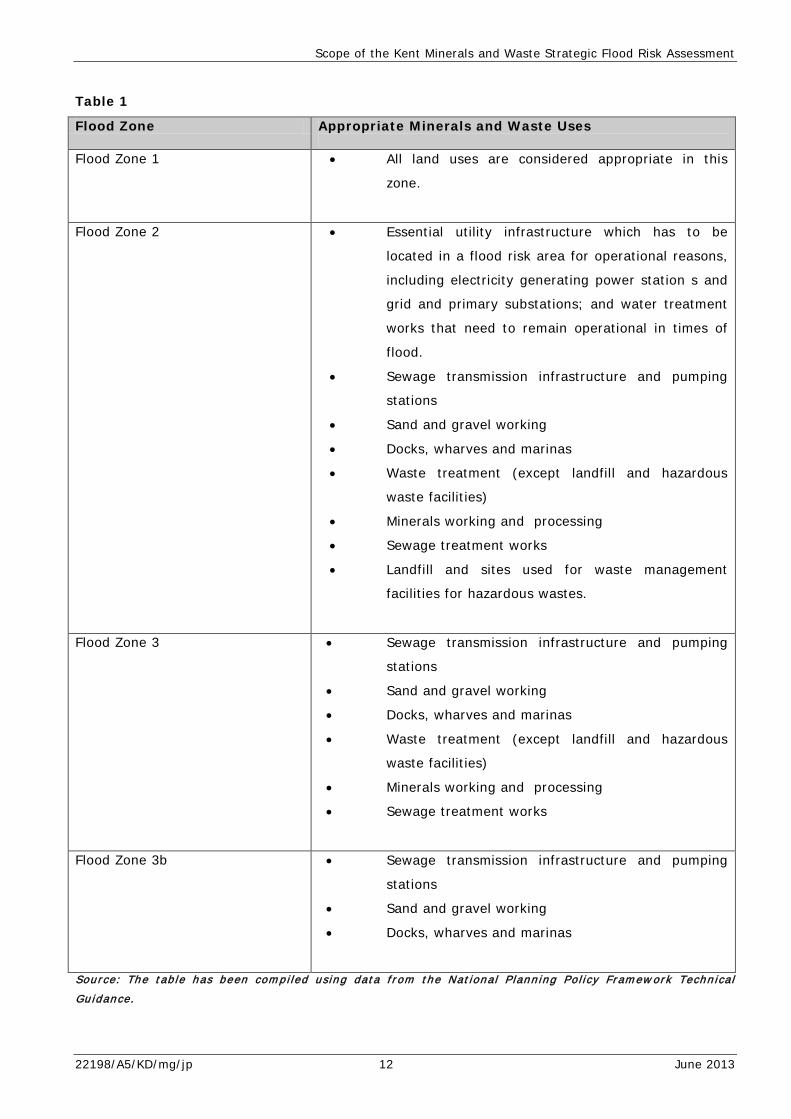
Table 1
Flood Zone Appropriate Minerals and Waste Uses
Flood Zone 1 • All land uses are considered appropriate in this
zone.
Flood Zone 2 • Essential utility infrastructure which has to be
located in a flood risk area for operational reasons,
including electricity generating power station s and
grid and primary substations; and water treatment
works that need to remain operational in times of
flood.
• Sewage transmission infrastructure and pumping
stations
• Sand and gravel working
• Docks, wharves and marinas
• Waste treatment (except landfill and hazardous
waste facilities)
• Minerals working and processing
• Sewage treatment works
• Landfill and sites used for waste management
facilities for hazardous wastes.
Flood Zone 3 • Sewage transmission infrastructure and pumping
stations
• Sand and gravel working
• Docks, wharves and marinas
• Waste treatment (except landfill and hazardous
waste facilities)
• Minerals working and processing
• Sewage treatment works
Flood Zone 3b • Sewage transmission infrastructure and pumping
stations
• Sand and gravel working
• Docks, wharves and marinas
Sou rce : The t ab le has been com p i l ed u s ing da t a f r om the N a t iona l P lann ing P o l i cy Fram ew ork Techn i ca l
Gu idance .
22198/A5/KD/mg/jp 12 June 2013
Scope of the Kent Minerals and Waste Strategic Flood Risk Assessment
Exception test
3.19 To meet the Sequential Test, development needs to be considered an appropriate use within
the flood zone. Should this not be the case, it will be necessary for the exception test to be
met. This will require consideration of flood risk management infrastructure, the impact,
speed and onset together with depth and velocity of flooding.
Climate Change
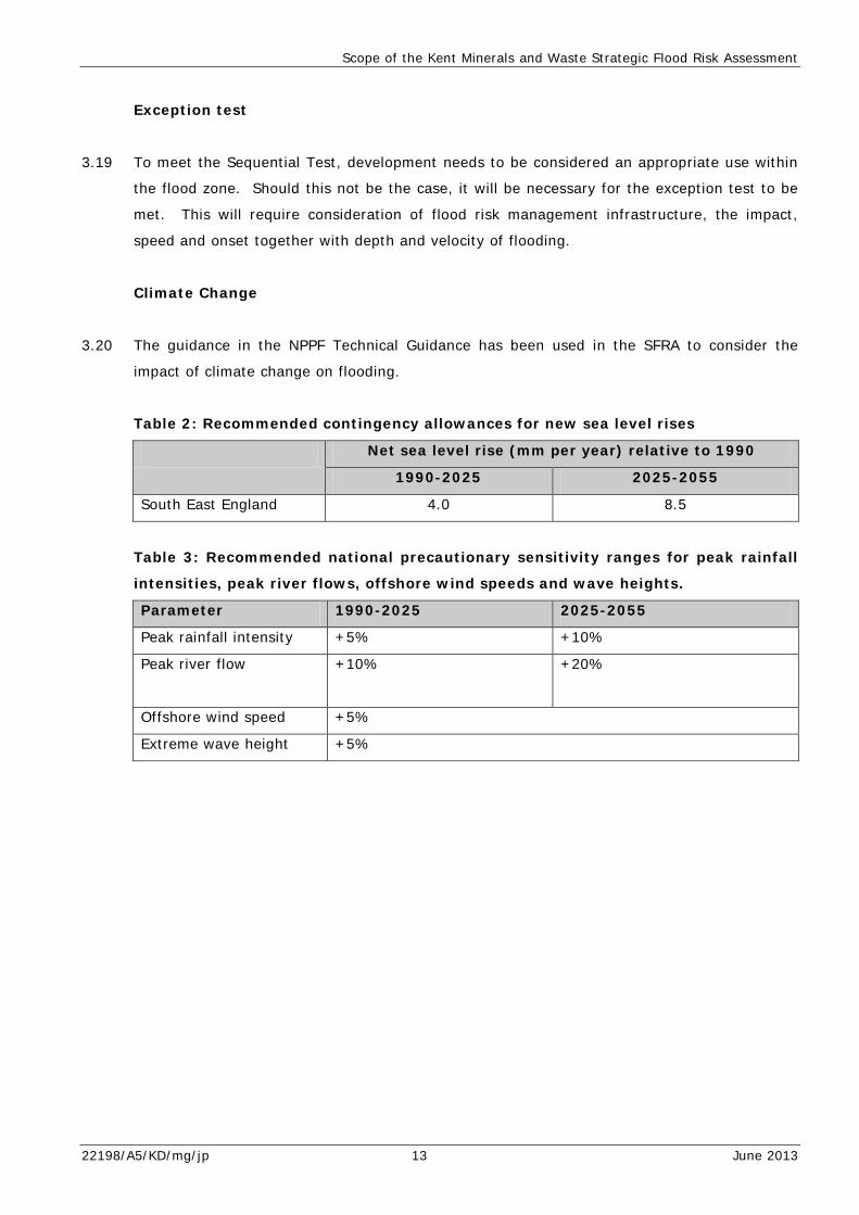
3.20 The guidance in the NPPF Technical Guidance has been used in the SFRA to consider the
impact of climate change on flooding.
Table 2: Recommended contingency allowances for new sea level rises
Net sea level rise (mm per year) relative to 1990
1990-2025 2025-2055
South East England 4.0 8.5
Table 3: Recommended national precautionary sensitivity ranges for peak rainfall
intensities, peak river flows, offshore wind speeds and wave heights.
Parameter 1990-2025 2025-2055
Peak rainfall intensity +5% +10%
Peak river flow
+10% +20%
Offshore wind speed +5%
Extreme wave height +5%
22198/A5/KD/mg/jp 13 June 2013
Strategic Sites in the Kent Minerals and Waste Local Plan
4.0 STRATEGIC SITES IN THE KENT MINERALS AND WASTE LOCAL PLAN
4.1 The Kent Minerals and Waste Local Plan identifies two strategic sites for allocation. The site
of the proposed Medway Cement Works at Holborough and its permitted minerals reserves
are identified as a strategic site for cement manufacture.
4.2 The proposed extension areas for Norwood Quarry and Landfill site on the Isle of Sheppey
are also identified as Strategic Sites for Waste in the Kent Minerals and Waste Local Plan. It
is proposed mineral working and restoration by hazardous landfill and any ancillary treatment
plant will be permitted.
Medway Cement Works, Holborough
4.3 The site straddles the boundary between the Borough of Tonbridge and Malling and Medway
and is located to the north of Snodland. The site area shown in Figure 12 of the Minerals
and Waste Local Plan 2013-2010 shows the site area. The site was granted planning
permission in 1998 for a cement works, chalk quarry and ancillary development (Planning
reference number: TM/98/785). Subsequent applications associated with the discharge of
the attached conditions have been submitted, the most recent in January 2008.
4.4 The red line boundary shown on Figure 12 represents the boundary of the 1998 planning
permission and within the boundary lies an extraction area whilst to the east lies the
indicative location of the cement works and east bund. Surrounding the red line boundary, to
the east, south and west lies a Minerals Consultation Area. The minerals consultation area is
used to alert future developers seeking to develop on land surrounding the site, that a
minerals site and associated cement works is proposed in close proximity and that
development surrounding the site may impact on the operations of the Medway Works. The
plan of the site can be found at Appendix 1 of the SFRA, shows the same site boundaries as
shown in Figure 12 of the Minerals and Waste Local Plan 2013-2030.
4.5 To analyse the impact of flooding and flood risk within the immediate and wider vicinity of
the site it is necessary to consider flooding from a range of sources as outlined in section 3.
For the purposes of analysing the site the land within the minerals consultation area and
planning consent (ie. the extraction area, east bund and cement works) have been included
in the analysis.
22198/A5/KD/mg/jp 14 June 2013

Strategic Sites in the Kent Minerals and Waste Local Plan
4.6 The table below summarises the types of flooding which affect the site.
Table 4
Type of flooding Status
Flooding from rivers and the sea The site is within flood zones 2 and 3.
Is the site within Flood Zone 3b (the
Functional Floodplain)?
No
Surface water flooding from rainfall The site is at risk of surface water flooding
from rainfall.
Source Protection Zone The site is within SPZ 2 and 3.
Flood History No
Is the site in an area benefitting from flood
defences?
No
Flooding from Sewers Previous incidents of flooding from sewers
have been reported within 1 km of the site.
Due to commercial confidentiality it is
unknown if the site has been directly affected
by flooding from sewers in the past.
4.7 The map at Appendix 1 shows the extent of flooding from rivers and the location of flood
zones 1, 2, 3 and 3b. The majority of the site is within flood zone 1 and therefore has a low
probability of experiencing flooding from rivers. A small area of land in the eastern part of
the site is within flood zone 3. The map shows the area of flooding extends across the
mineral consultation area into the area shown on the plan as the proposed cement works. A
small area of land within flood zone 3 is shown in the south east corner of the mineral
consultation area.
4.8 The sequential test identifies minerals working and processing to be appropriate for land
within flood zones 1,2 and 3 and therefore the proposal meets the requirements of the
sequential test.
4.9 Land to the east of the site is within flood zones 2, 3 and 3b. Any operations on the Medway
Works site will need to consider the impact of flooding on the wider area.
4.10 Table 4 identifies the site is at risk of flooding from surface water and flooding from sewers.
The site is also within source protection zones 2 and 3. When considering site design and
layout it will be necessary to ensure appropriate mitigation measures are used to ensure
operations on site do not lead to contamination of groundwater and the Source Protection
22198/A5/KD/mg/jp 15 June 2013

Strategic Sites in the Kent Minerals and Waste Local Plan
Zones. Mitigation measures will also be required to ensure buildings onsite used by
employees are not adversely affected by flooding and does not compromise staff safety.
4.11 Flooding is likely to become more frequent and severe during the plan period due to the
impact of climate change. It is likely the site will experience flooding more frequently. It
will be necessary for any planning application for the site to be accompanied by a Flood Risk
Assessment which assesses the impact of flooding on the site in more detail and identifies
appropriate mitigation measures on site which reduce the frequency and severity of flooding
both on site and across the wider area. The Flood Risk Assessment will also need to
consider the impact of climate change on flooding both to the site and surrounding area and
seek to mitigate its impact.
Norwood Quarry and Landfill
4.12 Norwood Quarry and Landfill site is located on the Isle of Sheppey and surrounded on the
northern, eastern and southern sides by farmland. To the west lies semi detached and
detached residential properties. A farm lies to the north east of the site and Lower Road lies
to the south.
4.13 The table below summarises the types of flooding which affect the site.
Table 5
Type of flooding Status
Flooding from rivers and the sea The site is not within flood zones 2 and 3.
Is the site within Flood Zone 3b (the
Functional Floodplain)?
The site is not within flood zone 3b.
Surface water flooding from rainfall Yes
Source Protection Zone No SPZ 1, 2, 3 or 4
Flood History No
Is the site in an area benefitting from
flood defences?
No
Flooding from Sewers Previous incidents of flooding from sewers have been reported within 1 km of the site. Due to commercial confidentiality it is unknown if the site has been directly affected by flooding from sewers in the past.
22198/A5/KD/mg/jp 16 June 2013
Strategic Sites in the Kent Minerals and Waste Local Plan
4.14 The map at Appendix 1 shows the extent of flooding from flood zones 1, 2, 3 and 3b. The
site is within flood zone 1 and therefore has a low risk of experiencing flooding from rivers
and the sea. The sequential test identifies minerals extraction and landfill sites used for
waste management facilities for hazardous waste as appropriate for land within flood zone 1.
4.15 The land surrounding the site is also shown to be within flood zone 1 and therefore has a low
probability of experiencing flooding from rivers or the sea.
4.16 The table above indicates the site is at risk of experiencing flooding from surface water. It is
therefore recommended appropriate mitigation measures are incorporated into the site
design to mitigate surface water flooding on site and the surrounding area.
4.17 Previous incidents of flooding from sewers have been recorded within 1km of the site
however due to commercial confidentiality it is unknown if the site has been directly affected
in the past. However it is considered appropriate for consideration is given to mitigating the
impact of flooding from sewers through site design and layout.
4.18 The effects of climate during the plan period are likely to result in an increase in peak rainfall
intensity and river flow. The site may experience an increased occurrence and/or severity of
surface water flooding during the plan period and this should be considered in the site
specific flood risk assessment in support of any planning permission for the extension of the
facility.
Summary
4.19 The two strategic sites in the Kent Minerals and Waste Local Plan meet the requirements of
the Sequential Test. It is recommended any future development considers design and layout
to mitigate against any flooding both on and off site and the impacts of climate change on
flooding are considered.
22198/A5/KD/mg/jp 17 June 2013

Safeguarded Wharves and Railheads
5.0 SAFEGUARDED WHARVES AND RAILHEADS
5.1 Policy CSM10 of the Draft Kent Minerals and Waste Local Plan 2013-2030 makes provision to
safeguard existing wharves and railheads for the importation of minerals in Kent. The
following section analyses the impact of flooding on these sites. Each site is assessed in
turn.
Allington Rail Sidings
5.2 The associated flood risk map for the site can be found at Appendix 2. The site imports
minerals for use in the construction industry. To the north and east of the site lies the River
Medway and to the east is the Medway Valley railway line with mature trees forming the
boundary between the two. South and west of the site lies the existing 20/20 Industrial
Estate and railway line between Ashford and London Victoria. To the west lies the 20
Allington Energy from Waste facility and to the north is the M20.
5.3 Table 6 below details the flooding types which affect the site.
Table 6
Category Status
Flooding from the Rivers and Sea The site is in Flood Zone 1 with 0% of the site in Flood Zones 2 and 3.
Is the site within Flood Zone 3b (functional floodplain)?
No
Surface Flooding from Rainfall The site is at risk from surface flooding from rainfall.
Groundwater Source Protection Zone (SPZ) The site is in SPZ 1.
Flood History The site does not have a history of flooding
Is the site in an area benefitting from flood defences
No
Flooding from Sewers Previous incidents of flooding from sewers have been reported within 1 km of the site. Due to commercial confidentiality it is unknown if the site has been directly affected by flooding from sewers in the past.
22198/A5/KD/mg/jp 18 June 2013
Safeguarded Wharves and Railheads
5.4 The plan shows the site is within flood zone 1 and therefore has a low probability of flooding
from rivers and the sea. Minerals workings and processing sites are identified as being
suitable for land within Flood Zone 1 and therefore the site meets the requirements of the
sequential test.
5.5 Land to the north east of the site is within flood zones 2 and 3 and the stretch of the River
Medway north of the site, shown on the plan, benefits from flood defences. However land to
the south of the defences is shown to be in flood zone 3. Any future development on the
site will need to consider the use of mitigation measures, through site design and layout to
mitigate against the impact of flooding from the wider area.
5.6 The site has been identified as at risk of flooding from surface water and flooding from
sewers. Any future proposals for the site will need to consider the use of mitigation
measures to reduce the risk of flooding and prevent contamination of surface water from
operations on site and entering the groundwater supply.
5.7 The effect of climate change is likely to result in peak rainfall intensity and river flow
increasing during the plan period. The site is likely to experience more frequent and/or
severe incidents of surface water flooding and therefore it will be necessary for any future
proposals for the site to mitigate against the impacts of climate change.
Sevington Rail Depot
5.8 The flood risk map for the site can be found at Appendix 2. The site is used for the
importation of aggregates. North of the site lies the railway line between Folkestone and
Ashford. To the east of the site lies Cheeseman’s Green Lane with agricultural land beyond
and detached dwellings. To the west of the site lies the existing Sevington Recycling Dept
which is currently used as a construction and demolition waste recycling facility.
5.9 Table 7 below details the flooding types which affect the site.
22198/A5/KD/mg/jp 19 June 2013

Safeguarded Wharves and Railheads
Table 7 Category Status
Flooding from the Rivers and Sea The site is in Flood Zone 1 with 0% of the site in Flood Zone 2 and 3.
Is the site within Flood Zone 3b (functional floodplain)?
No
Surface Flooding from Rainfall The site is at risk from surface flooding from rainfall.
Groundwater Source Protection Zone (SPZ) The site is not in SPZ 1, 2, 3, or 4.
Flood History The site does have a history of flooding
Is the site in an area benefitting from flood defences
No
Flooding from Sewers Previous incidents of flooding from sewers have been reported within 1 km of the site. Due to commercial confidentiality it is unknown if the site has been directly affected by flooding from sewers in the past.
5.10 The flood risk map shows the site is within flood zone 1 and is therefore considered to have
a low risk of experiencing flooding from rivers and the sea. Minerals use on the site meets
the requirements of the sequential test as minerals importation facilities are considered
acceptable on land within flood zone 1.
5.11 The site has been identified as being at risk of surface flooding from rainfall and flooding
from sewers. It will therefore be necessary for any future proposals to mitigate against the
impacts of flooding from sewers and to ensure surface water is not contaminated.
5.12 Land to the south west of the site is shown on the plan to be within flood zone 2 and 3 with
some stretches of land benefitting from flood defences.
5.13 Future proposals for the site will be required to incorporate mitigation measures to reduce
the occurrence and/or severity of flooding on the site and to ensure any proposals do not
exacerbate flooding in the surrounding area.
5.14 The effect of climate change is likely to result in peak rainfall intensity and river flow
increasing during the plan period. The site is likely to experience more frequent and/or
severe incidents of surface water flooding and therefore it will be necessary for any future
proposals for the site to mitigate against the impacts of climate change.
22198/A5/KD/mg/jp 20 June 2013
Safeguarded Wharves and Railheads
Hothfield Works
5.15 The site is a minerals railhead located to the south east of Charing. To the north of the site
is agricultural land, a dwelling and the M20. To the east of the site lies agricultural land and
the M20 whilst to the south east of the site is Sunnybridge Farm. Adjacent to the site and
forming the south western boundary is the railway line between Ashford and London Victoria.
To the west of the site also lies the Channel Tunnel rail line and to the north west lies
agricultural land.
5.16 Table 8 below details the flooding types which affect the site and the plan at Appendix 2
shows the extent of flood zones 1, 2, 3 and 3b.
Table 8
Category Status
Flooding from the Rivers and Sea The site is in Flood Zone 1 with 0% of the site in Flood Zones 2 and 3.
Is the site within Flood Zone 3b (functional floodplain)?
No
Surface Flooding from Rainfall The site is at risk from surface flooding from rainfall.
Groundwater Source Protection Zone (SPZ) The site is in SPZ 2, 3, and 4.
Flood History The site does not have a history of flooding
Is the site in an area benefitting from flood defences
No
Flooding from Sewers No previous incidents of flooding from sewers have been reported within 1km of the site.
5.17 A flood risk map is also included at Appendix 2 which shows the site and surrounding land is
within flood zone 1 and therefore has a low risk of flooding from rivers. Minerals use on the
site meets the requirements of the sequential test as minerals importation facilities are
considered acceptable on land within flood zone 1. The site is in Source Protection Zones 2,
3 and 4 and has been identified as at risk of flooding from surface water.
5.18 Future proposals for the site will be required to incorporate mitigation measures to reduce
the occurrence and/or severity of flooding on the site and to ensure any proposals do not
adversely affect surface water flooding and operations on site do not contaminate
groundwater or surface water.
22198/A5/KD/mg/jp 21 June 2013
Safeguarded Wharves and Railheads
5.19 The effect of climate change is likely to result in peak rainfall intensity and river flow
increasing during the plan period. The site is likely to experience more frequent and/or
severe incidents of surface water flooding and therefore it will be necessary for any future
proposals for the site to mitigate against the impacts of climate change.
East Peckham
5.20 The site at East Peckham is a railhead used for the handling of minerals. It is located to the
east of East Peckham with the railway line between Maidstone and Tonbridge forming the
eastern boundary of the site. To the south of the site is land currently being worked for
sharp sand and gravel. To the east of the site lies the A228 and agricultural land whilst to
the north is a sewage works and former sand and gravel workings which have undergone
restoration.
5.21 Table 9 below details the flooding types which affect the site and the plan at Appendix 2
shows the extent of flood zones 1, 2, 3 and 3b.
Table 9
Category Status
Flooding from the Rivers and Sea The site is in Flood Zone 2 with 100% of the site in Flood Zone 2 and 88% in Flood Zone 3.
Is the site within Flood Zone 3b (functional floodplain)?
Yes
Surface Flooding from Rainfall The site is at risk from surface flooding from rainfall.
Groundwater Source Protection Zone (SPZ) The site is not in SPZ 1, 2, 3, or 4.
Flood History The site has a history of flooding
Is the site in an area benefitting from flood defences
No
Flooding from Sewers Previous incidents of flooding from sewers have been reported within 1 km of the site. Due to commercial confidentiality it is unknown if the site has been directly affected by flooding from sewers in the past.
22198/A5/KD/mg/jp 22 June 2013
Safeguarded Wharves and Railheads
5.22 The flood risk map at Appendix 2 shows the site is within Flood Zones 3 and 3b. Sand and
gravel processing is considered appropriate within flood zone 3 and therefore the land
adjacent to the railway line meets the sequential test. However the land to the east is within
flood zone 3b and therefore does not meet the sequential test.
5.23 Planning permission was granted for the permanent use of the rail sidings for the importation
of construction aggregates and relocation of the ready mix concrete plant (Planning
application ref: TM11/1096). Condition 17 of the decision notice requires flood safety
measures to be implemented on site including the retention of portacabins on legs, retention
of refuge area, escape route for staff and retention of permeable areas.
5.24 The recent planning application however, includes details of the mitigation measures to be
used on site to reduce the impact of flooding and these have been approved by the
Environment Agency through the development management process.
5.25 Any future development at the site will be required to take into consideration the impact of
flooding on the site and surrounding area particularly as the majority of the surrounding land
is within flood zone 3b.
5.26 The effect of climate change is likely to result in peak rainfall intensity and river flows
increasing during the plan period. The site is likely to experience more frequent and/or
severe incidents of surface water flooding and therefore it will be necessary for any future
proposals for the site to mitigate against the impacts of climate change
Ridham Dock (both Operational Sites)
5.27 Ridham Dock comprises 2 sites. One is operated by Tarmac and the other by Bretts and both
are used to import aggregates and are adjacent to the River Swale. The site operated by
Bretts is ‘L’ shaped with a metal recycling site to the east and industrial area to the south
and west.
5.28 The site operated by Tarmac lies to the west of the Bretts site. To the east is the River
Swale and to the south is an industrial estate. Whilst to the west lies scrubland and to the
north of both sites is the River Swale.
5.29 Table 10 below details the flooding types which affect the site and the plan at Appendix 2
shows the extent of flood zones 1, 2, 3 and 3b.
22198/A5/KD/mg/jp 23 June 2013
Safeguarded Wharves and Railheads
Table 10
Category Status
Flooding from the Rivers and Sea The site is in Flood Zone 2 with 100% of the site in Flood Zone 2 and 100% in Flood Zone 3.
Is the site within Flood Zone 3b (functional floodplain)?
Yes
Surface Flooding from Rainfall The site is at risk from surface flooding from rainfall.
Groundwater Source Protection Zone (SPZ)
The site is not in SPZ 1, 2, 3, or 4.
Flood History The site does have a history of flooding
Is the site in an area benefitting from flood defences
Yes
Flooding from Sewers No previous incidents of flooding from sewers have been reported within 1km of the site.
5.30 The flood risk map at Appendix 3 shows the sites are both within flood zone 3 with a large
part of the Brett site within an area benefitting from flood defences. The sequential test
identifies land within flood zone 3 as appropriate land uses for wharves and minerals working
and processing and therefore the site meet the requirements of the sequential test.
5.31 Future proposals for the site will be required to incorporate mitigation measures to reduce
the occurrence and/or severity of flooding on the site and to ensure any proposals do not
adversely affect surface water flooding and operations on site do not contaminate
groundwater or surface water.
5.32 The effect of climate change is likely to result in peak rainfall intensity and river flow
increasing during the plan period. The site is likely to experience more frequent and/or
severe incidents of surface water flooding and therefore it will be necessary for any future
proposals for the site to mitigate against the impacts of climate change.
Johnson’s Wharf Greenhithe
5.33 Johnson’s Wharf is an aggregate importation facility located on the River Thames to the west
of Greenhithe. To the east of the site lies residential development and to the south is an
Asda supermarket and the A206. To the west of the site lies an industrial estate and office
block.
22198/A5/KD/mg/jp 24 June 2013

Safeguarded Wharves and Railheads
5.34 Table 11 below details the flooding types which affect the site and the plan at Appendix 2
shows the extent of flood zones 1, 2, 3 and 3b.
Table 11
Category Status
Flooding from the Rivers and Sea The site is in Flood Zone 2 with 87% of the site in Flood Zone 2 and 87% in Flood Zone 3.
Is the site within Flood Zone 3b (functional floodplain)?
No
Surface Flooding from Rainfall The site is at risk from surface flooding of rainfall.
Groundwater Source Protection Zone (SPZ) The site is in SPZ 3
Flood History The site does not have a history of flooding
Is the site in an area benefitting from flood defences
Yes
Flooding from Sewers Previous incidents of flooding from sewers have been reported within 1 km of the site. Due to commercial confidentiality it is unknown if the site has been directly affected by flooding from sewers in the past.
5.35 The plan shows the majority of the site is within flood zone 3 and is within an area
benefitting from flood defences. A line of flood defences run between the land and River
Thames adjacent to the site. The sequential test identifies land within flood zone 3 as
appropriate land uses for wharves and minerals working and processing and therefore the
site meets the requirements of the Sequential Test.
5.36 The plan also shows land surrounding the site is also within flood zone 3 and within an area
benefitting from flood defences.
5.37 The site has been identified as at risk of flooding from rainfall and within source protection
zone 3. Future proposals for the site will need to ensure mitigation measures are included in
the site design and layout to ensure contamination of ground and surface water does not
occur or have an adverse impact on groundwater quality.
22198/A5/KD/mg/jp 25 June 2013
Safeguarded Wharves and Railheads
5.38 The effect of climate change is likely to result in peak rainfall intensity and river flow
increasing. In regards to the site it is likely incidents of surface water flooding will be more
frequent and/or more severe during the plan period. It will therefore be necessary for any
future proposals for the site to mitigate against flooding and for adjacent or nearby
development proposals not to acerbate flooding on the site.
Robins Wharf, Northfleet (both operations sites)
5.39 Robins Wharf is located to the north of Northfleet adjacent to the River Thames. The site
comprises two parts. The north western part is operated by Brett and the Southern part is
operated by Aggregate Industries. To the north west of the site lies an existing industrial
estate whilst to the north and north west lies the River Thames. To the south east of the
site lies scrubland and industrial buildings. The table below summarises flood risk on the
two sites.
Table 12
Category Status
Flooding from the Rivers and Sea The site is in Flood Zone 2 with 100% of the site in Flood Zone 2 and 100% in Flood Zone 3.
Is the site within Flood Zone 3b (functional floodplain)?
No
Surface Flooding from Rainfall The site is at risk from surface flooding from rainfall.
Groundwater Source Protection Zone (SPZ) The site is in SPZ 2.
Flood History The site does have a history of flooding
Is the site in an area benefitting from flood defences
Yes
Flooding from Sewers Previous incidents of flooding from sewers have been reported within 1 km of the site. Due to commercial confidentiality it is unknown if the site has been directly affected by flooding from sewers in the past.
5.40 A flood risk map for the site can be found at Appendix 2. The site is shown to fall within
flood zones 2 and 3 and therefore has a high probability of experiencing flooding from rivers
and the sea. Minerals use on the site meets the requirements of the sequential test as
minerals importation facilities are considered acceptable on land within flood zones 2 and 3.
Land surrounding the site is also shown on the plan as being within flood zones 2 and 3.
22198/A5/KD/mg/jp 26 June 2013
Safeguarded Wharves and Railheads
Future development on the site will need to incorporate mitigation measures to ensure
flooding both on site and in the wider area are not exacerbated by any proposals on the site.
5.41 The site has been identified as at risk flooding from rainfall and is within source protection
zone 2. Any future proposals for the site will therefore need to take into consideration and
incorporate suitable mitigation measures to ensure contamination of surface and ground
water does not occur as a result of operations on site.
5.42 The effect of climate change is likely to result in peak rainfall intensity and river flow
increasing. In regards to the site it is likely incidents of surface water flooding will be more
frequent and/or more severe during the plan period. It will therefore be necessary for any
future proposals for the site to mitigate against flooding and for adjacent or nearby
development proposals not to acerbate flooding on the site.
Denton Marine Terminal
5.43 Denton Marine Terminal is east of Gravesend and fronts onto the River Thames. To the east
of the site lies the Police Training centre and National Sea Training Centre. To the south of
the site lies the railway line and sewage works beyond. Whilst to the west is a container
storage site and industrial areas. Table 13 below summarises the risk of flooding to the site.
Table 13
Category Status
Flooding from the Rivers and Sea The site is in Flood Zone 2 (94% of the site area) and Flood Zone 3 (94% of the site area)
Is the site within Flood Zone 3b (functional floodplain)?
No
Surface Flooding from Rainfall The site is at risk from surface flooding from rainfall.
Groundwater Source Protection Zone (SPZ) The site is not in SPZ 1, 2, 3, or 4.
Flood History The site does have a history of flooding
Is the site in an area benefitting from flood defences
Yes
Flooding from Sewers Previous incidents of flooding from sewers have been reported within 1 km of the site. Due to commercial confidentiality it is unknown if the site has been directly affected by flooding from sewers in the past.
22198/A5/KD/mg/jp 27 June 2013

Safeguarded Wharves and Railheads
5.44 A plan showing the extent of flooding on the site and surrounding area can be found at
Appendix 2.
5.45 The site comprises two parts. The southern part is located on land with the northern part
extending into the River Thames. Flood defences run through the centre of the site. The
site is within flood zones 2 and 3 and therefore has a high probability of experiencing
flooding from rivers and the sea. Minerals use on the site meets the requirements of the
sequential test as minerals importation facilities are considered acceptable on land within
flood zones 2 and 3.
5.46 The site is in an area benefitting from flood defences and has a history of flooding. It has
also been identified as at risk of flooding from surface water. Any future development on the
site will need to consider site design and layout to ensure the proposal does not exacerbate
flooding on the site and within the wider area and operations on site do not contaminate
surface water.
5.47 The effect of climate change is likely to result in peak rainfall intensity, river flow and sea
levels increasing. In regards to the site it is likely incidents of surface water flooding will be
more frequent and/or more severe during the plan period. It will therefore be necessary for
any future proposals for the site to mitigate against flooding and for adjacent or nearby
development proposals not to acerbate flooding on the site.
East Quay, Whitstable
5.48 The site is used for the importation of aggregates. To the north of the site is a public house
and the beach whilst to the east is other industrial buildings and car parking. To the south
lies Whitstable Lifeboat station and to the west is Whitstable Harbour. Table 14 below
summarises the types of flooding which affect the site.
22198/A5/KD/mg/jp 28 June 2013
Safeguarded Wharves and Railheads
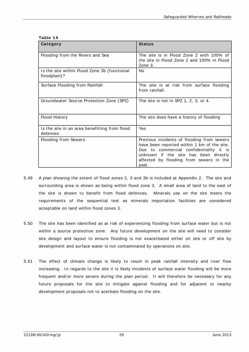
Table 14 Category Status
Flooding from the Rivers and Sea The site is in Flood Zone 2 with 100% of the site in Flood Zone 2 and 100% in Flood Zone 3.
Is the site within Flood Zone 3b (functional floodplain)?
No
Surface Flooding from Rainfall The site is at risk from surface flooding from rainfall.
Groundwater Source Protection Zone (SPZ) The site is not in SPZ 1, 2, 3, or 4.
Flood History The site does have a history of flooding
Is the site in an area benefitting from flood defences
Yes
Flooding from Sewers Previous incidents of flooding from sewers have been reported within 1 km of the site. Due to commercial confidentiality it is unknown if the site has been directly affected by flooding from sewers in the past.
5.49 A plan showing the extent of flood zones 2, 3 and 3b is included at Appendix 2. The site and
surrounding area is shown as being within flood zone 3. A small area of land to the east of
the site is shown to benefit from flood defences. Minerals use on the site meets the
requirements of the sequential test as minerals importation facilities are considered
acceptable on land within flood zones 3.
5.50 The site has been identified as at risk of experiencing flooding from surface water but is not
within a source protection zone. Any future development on the site will need to consider
site design and layout to ensure flooding is not exacerbated either on site or off site by
development and surface water is not contaminated by operations on site.
5.51 The effect of climate change is likely to result in peak rainfall intensity and river flow
increasing. In regards to the site it is likely incidents of surface water flooding will be more
frequent and/or more severe during the plan period. It will therefore be necessary for any
future proposals for the site to mitigate against flooding and for adjacent or nearby
development proposals not to acerbate flooding on the site.
22198/A5/KD/mg/jp 29 June 2013

Safeguarded Wharves and Railheads
Red Lion Wharf
5.52 Red Lion Wharf is located to the north of Northfleet adjacent to the River Thames and is
used for aggregate importation. The site is surrounded by industrial units and an area of
derelict land to the south of the site. Table 15 below summarises the types of flooding which
affect the site.
Table 15 Category Status
Flooding from the Rivers and Sea The site is in Flood Zone 2 with 72% of the site in Flood Zone 2 and 72% in Flood Zone 3.
Is the site within Flood Zone 3b (functional floodplain)?
No
Surface Flooding from Rainfall The site is at risk from surface flooding of rainfall.
Groundwater Source Protection Zone (SPZ) The site is in SPZ 2
Flood History The site does not have a history of flooding
Is the site in an area benefitting from flood defences
Yes
Flooding from Sewers Previous incidents of flooding from sewers have been reported within 1 km of the site. Due to commercial confidentiality it is unknown if the site has been directly affected by flooding from sewers in the past.
5.53 A flood risk plan of the site can be found at appendix 2. The site is shown to be within flood
zone 3 but is not within flood zone 3b. The plan also shows the land surrounding the site is
also within flood zones 2 and 3. Although the site is within an area benefitting from flood
defences. Minerals use on the site meets the requirements of the sequential test as
minerals importation facilities are considered acceptable on land within flood zones 3.
5.54 The site has been identified as at risk of experiencing flooding from surface water and is
within source protection zone 2. Future development on the site will need to consider site
design and layout to ensure appropriate mitigation measures are used to prevent surface
water and groundwater from being contaminated by either operations on site or flooding
from sewers. Consideration will also need to be given to the use of mitigation measures to
22198/A5/KD/mg/jp 30 June 2013
Safeguarded Wharves and Railheads
ensure flood risk is not exacerbated on site and within the surrounding area by any new
development on site and if so, appropriate measures will need to be implemented.
5.55 The effect of climate change is likely to result in peak rainfall intensity and river flow
increasing. In regards to the site it is likely incidents of surface water flooding will be more
frequent and/or more severe during the plan period. It will therefore be necessary for any
future proposals for the site to mitigate against flooding and for adjacent or nearby
development proposals not to acerbate flooding on the site.
Ramsgate Harbour
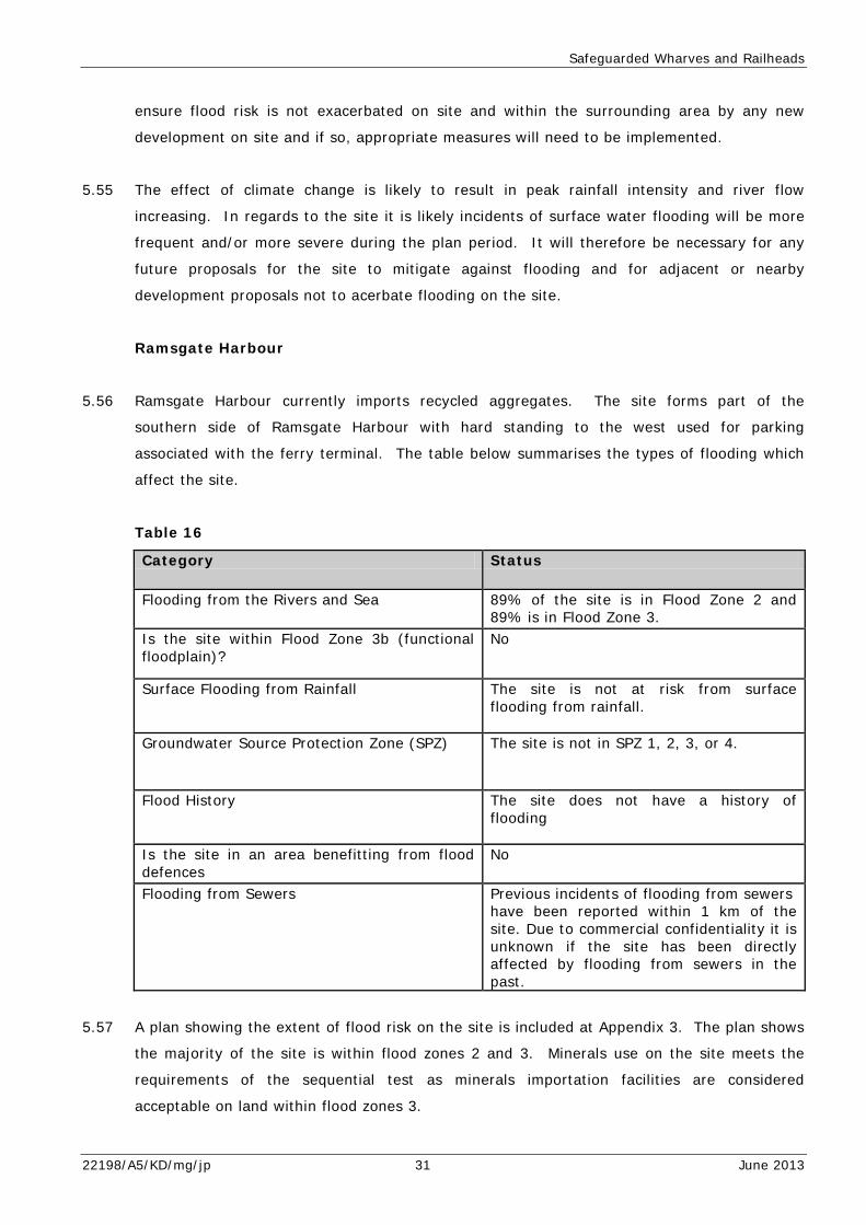
5.56 Ramsgate Harbour currently imports recycled aggregates. The site forms part of the
southern side of Ramsgate Harbour with hard standing to the west used for parking
associated with the ferry terminal. The table below summarises the types of flooding which
affect the site.
Table 16
Category Status
Flooding from the Rivers and Sea 89% of the site is in Flood Zone 2 and 89% is in Flood Zone 3.
Is the site within Flood Zone 3b (functional floodplain)?
No
Surface Flooding from Rainfall The site is not at risk from surface flooding from rainfall.
Groundwater Source Protection Zone (SPZ) The site is not in SPZ 1, 2, 3, or 4.
Flood History The site does not have a history of flooding
Is the site in an area benefitting from flood defences
No
Flooding from Sewers Previous incidents of flooding from sewers have been reported within 1 km of the site. Due to commercial confidentiality it is unknown if the site has been directly affected by flooding from sewers in the past.
5.57 A plan showing the extent of flood risk on the site is included at Appendix 3. The plan shows
the majority of the site is within flood zones 2 and 3. Minerals use on the site meets the
requirements of the sequential test as minerals importation facilities are considered
acceptable on land within flood zones 3.
22198/A5/KD/mg/jp 31 June 2013
Safeguarded Wharves and Railheads
5.58 The site has not been identified as at risk of flooding from surface water and is not within a
source protection zone. Future development on the site will need to consider site design and
layout to ensure appropriate mitigation measures are used to prevent surface water from
being contaminated by either operations on site or flooding from sewers.
5.59 The effect of climate change is likely to result in peak rainfall intensity and river flow
increasing. In regards to the site it is likely incidents of surface water flooding will be more
frequent and/or more severe during the plan period. It will therefore be necessary for any
future proposals for the site to mitigate against flooding and for adjacent or nearby
development proposals not to acerbate flooding on the site.
Wharf 42, Northfleet (including Northfleet Cement Works)
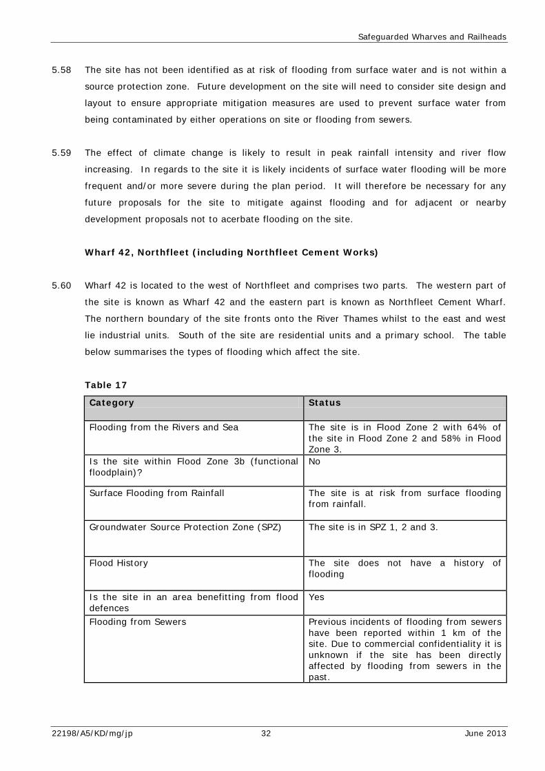
5.60 Wharf 42 is located to the west of Northfleet and comprises two parts. The western part of
the site is known as Wharf 42 and the eastern part is known as Northfleet Cement Wharf.
The northern boundary of the site fronts onto the River Thames whilst to the east and west
lie industrial units. South of the site are residential units and a primary school. The table
below summarises the types of flooding which affect the site.
Table 17
Category Status
Flooding from the Rivers and Sea The site is in Flood Zone 2 with 64% of the site in Flood Zone 2 and 58% in Flood Zone 3.
Is the site within Flood Zone 3b (functional floodplain)?
No
Surface Flooding from Rainfall The site is at risk from surface flooding from rainfall.
Groundwater Source Protection Zone (SPZ) The site is in SPZ 1, 2 and 3.
Flood History The site does not have a history of flooding
Is the site in an area benefitting from flood defences
Yes
Flooding from Sewers Previous incidents of flooding from sewers have been reported within 1 km of the site. Due to commercial confidentiality it is unknown if the site has been directly affected by flooding from sewers in the past.
22198/A5/KD/mg/jp 32 June 2013
Safeguarded Wharves and Railheads
5.61 A plan showing the extent of flood zones 2, 3 and 3b in relation to the site can be found at
appendix 2. The plan shows the northern area of both parts of the site is within flood zones
2 and 3. Minerals use on the site meets the requirements of the sequential test as minerals
importation facilities are considered acceptable on land within flood zones 2 and 3.
5.62 The site has been identified as at risk of flooding from rainfall and is within source protection
zones 1, 2 and 3. Any future development on the site will therefore need to incorporate
mitigation measures through site design and layout, to ensure groundwater and surface
water are not contaminated from the operations on site or from flooding from sewers.
5.63 The effect of climate change is likely to result in peak rainfall intensity and river flow
increasing. In regards to the site it is likely incidents of surface water flooding will be more
frequent and/or more severe during the plan period. It will therefore be necessary for any
future proposals for the site to mitigate against flooding and for adjacent or nearby
development proposals not to acerbate flooding on the site.
Dunkirk Jetty (Dover Western Docks)
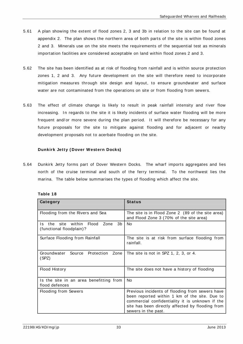
5.64 Dunkirk Jetty forms part of Dover Western Docks. The wharf imports aggregates and lies
north of the cruise terminal and south of the ferry terminal. To the northwest lies the
marina. The table below summarises the types of flooding which affect the site.
Table 18
Category Status
Flooding from the Rivers and Sea The site is in Flood Zone 2 (89 of the site area) and Flood Zone 3 (70% of the site area)
Is the site within Flood Zone 3b (functional floodplain)?
No
Surface Flooding from Rainfall The site is at risk from surface flooding from rainfall.
Groundwater Source Protection Zone (SPZ)
The site is not in SPZ 1, 2, 3, or 4.
Flood History The site does not have a history of flooding
Is the site in an area benefitting from flood defences
No
Flooding from Sewers Previous incidents of flooding from sewers have been reported within 1 km of the site. Due to commercial confidentiality it is unknown if the site has been directly affected by flooding from sewers in the past.
22198/A5/KD/mg/jp 33 June 2013
Safeguarded Wharves and Railheads
5.65 The plan at Appendix 2 shows the majority of the site lies within flood zones 2 and 3. The
site therefore has a medium – high risk of experiencing flooding from rivers or the sea.
Minerals use on the site meets the requirements of the sequential test as minerals
importation facilities are considered acceptable on land within flood zones 2 and 3.
5.66 The site has been identified as at risk of flooding from rainfall. Any future development on
the site will therefore need to incorporate mitigation measures to reduce the impact of
flooding from rivers, the sea and rainfall. This could be achieved through site design and
layout.
5.67 Technical Guidance which accompanies the NPPF indicates the impact of climate change
during the plan period will result in an increase in sea level, wave heights and off shore wind
speeds in addition to an increase in rainfall intensity. This may result flooding both within
the site and surrounding land will be more frequent and/or more severe. Any future
development will therefore be required to take this into consideration and ensure appropriate
mitigation measures are used on site to both reduce the occurrence and impact of flooding
on site and the surrounding land.
Sheerness
5.68 The site is located in the north western point of the Isle of Sheppey. The site currently
imports aggregates. The River Thames lies to the north of the site whilst to the west lies the
Medway estuary. To the south of the site lies industrial units and the docks. To the south
east lies the town of Sheerness. The table below summarises the types of flooding which
affect the site.
22198/A5/KD/mg/jp 34 June 2013
Safeguarded Wharves and Railheads
Table 19
Category Status
Flooding from the Rivers and Sea The site is in Flood Zone 2 with 31% of the site in Flood Zone 2 and 0% in Flood Zone 3.
Is the site within Flood Zone 3b (functional floodplain)?
No
Surface Flooding from Rainfall The site is at risk from surface flooding from rainfall.
Groundwater Source Protection Zone (SPZ)
The site is not in SPZ 1, 2, 3, or 4.
Flood History The site does have a history of flooding.
Is the site in an area benefitting from flood defences
No
Flooding from Sewers No previous incidents of flooding from sewers have been reported within 1km of the site.
5.69 A plan showing the extent of land within flood zones 2, 3 and 3b. The plan shows the
majority of the site lies within flood zone 1 with the southern part of the site within flood
zone 2. Therefore the southern part of the site has a medium risk of experiencing flooding
from rivers and the sea. Minerals use on the site meets the requirements of the sequential
test as minerals importation facilities are considered acceptable on land within flood zones 2
and 3.
5.70 The site has been identified as at risk of surface water flooding from rainfall but is not within
a source protection zone. Therefore any future development on the site will need to ensure
appropriate mitigation measures are used to reduce the impact and/occurrence of surface
water flooding on the site.
5.71 The site has been identified as at risk of flooding from rainfall. Any future development on
the site will therefore need to incorporate mitigation measures to reduce the impact of
flooding from rivers, the sea and rainfall. This could be achieved through site design and
layout.
5.72 Technical Guidance which accompanies the NPPF indicates the impact of climate change
during the plan period will result in an increase in sea level, wave heights and off shore wind
speeds in addition to an increase in rainfall intensity. This may result flooding both within
the site and surrounding land will be more frequent and/or more severe. Any future
development will therefore be required to take this into consideration and ensure appropriate
22198/A5/KD/mg/jp 35 June 2013

Safeguarded Wharves and Railheads
mitigation measures are used on site to both reduce the occurrence and impact of flooding
on site and the surrounding land.
Botany Marshes (Northfleet Wharf)
5.73 The site is used for the importation of aggregates. To the north, west and south of the site
lies marshland with the River Thames to the east of the site. To the south of the site also
lies industrial units. Manor Way, a single carriageway road serves the site and industrial
units to the south connecting them to Galley Hill Road.
Table 20
Category Status
Flooding from the Rivers and Sea The site is in Flood Zone 2 (96% of the site area) and Flood Zones 3 (96% of the site area)
Is the site within Flood Zone 3b (functional floodplain)?
No
Surface Flooding from Rainfall The site is at risk from surface flooding of rainfall.
Groundwater Source Protection Zone (SPZ) The site is in SPZ 3.
Flood History The site does have a history of flooding
Is the site in an area benefitting from flood defences
Yes
Flooding from Sewers No previous incidents of flooding from sewers have been reported within 1km of the site.
5.74 An application for a Certificate of Lawful or Proposed Use or Development was granted on 17
December 2012 (Reference number: GR/12/951) to enable the replacement of the existing
pipeline and supporting jetty and removal of the old one.
5.75 The flood risk plan at appendix 2 shows the western part of the site, on land, is within flood
zone 3 and within an area benefitting from flood defences.
5.76 Minerals use on the site meets the requirements of the sequential test as minerals
importation facilities are considered acceptable on land within flood zones 2 and 3.
22198/A5/KD/mg/jp 36 June 2013
Safeguarded Wharves and Railheads
5.77 The site has been identified as at risk of surface water flooding from rainfall and is in source
protection zone 2. Therefore any future development on the site will need to ensure
appropriate mitigation measures will need to be used to reduce the impact and/occurrence of
surface water flooding on the site and ensure groundwater and surface water are not
contaminated by operations on site.
5.78 The site has been identified as at risk of flooding from rainfall. Any future development on
the site will therefore need to incorporate mitigation measures to reduce the impact of
flooding from rivers, the sea and rainfall. This could be achieved through site design and
layout.
5.79 Technical Guidance which accompanies the NPPF indicates the impact of climate change
during the plan period will result in an increase in sea level, wave heights and off shore wind
speeds in addition to an increase in rainfall intensity. This may result flooding both within
the site and surrounding land will be more frequent and/or more severe. Any future
development will therefore be required to take this into consideration and ensure appropriate
mitigation measures are used on site to both reduce the occurrence and impact of flooding
on site and the surrounding land.
22198/A5/KD/mg/jp 37 June 2013

Policy CSW 18 Safeguarding Waste Sites
6.0 POLICY CSW 18 SAFEGUARDING WASTE SITES
6.1 Policy CSW18 concerns the safeguarding of existing waste sites across Kent. The aim of the
policy is to safeguard all the sites indentified for allocation in the Waste Sites DPD and all
permitted waste facilities in Kent. The policy does not include sites with temporary
permissions or sites with Certificate of Lawful Use or Development (CLUOD). Landfill sites
for inert waste have been granted permission as temporary use and therefore are not
covered by Policy CSW18.
6.2 The maps at Appendix 3 show the location of existing waste sites in Kent. For ease of
reference maps for north, east and west Kent have been produced.
North Kent
6.3 The plan shows the majority of the northern areas of the boroughs of Dartford, Gravesham
and Swale are within flood zones 3 and mall areas within flood zone 3b. A number of the
waste sites are shown to be within Flood Zones 3 and 3b.
East Kent
6.4 The plan for East Kent shows a significant area of land within Shepway and a small amount
of land within the Borough of Ashford within flood zones 3. The coastal area around
Dungeness is also shown to be within flood zone 3b. Land surrounding Richborough and to
the south within the District of Dover is also shown to be within flood zones flood zones 3
and 3b. A third area of land within flood zones 3 and 3b falls between the Borough’s of
Thanet, Canterbury and Dover. The plan shows a number of waste sites are located within
flood zones 3 and 3b in the Richborough area and several sites are shown to be within flood
zone 3 in the southern part of Shepway.
West Kent
6.5 The plan shows a central band of land within West Kent within flood zones 3 and 3b. The
flood zones straddle the Boroughs of Tonbridge and Malling, Maidstone, Tunbridge Wells and
Sevenoaks. Another area of land within flood zones 3 and 3b is located in the northern part
of Tonbridge and Malling in Snodland and Larkfield.
22198/A5/KD/mg/jp 38 June 2013

Policy CSW 18 Safeguarding Waste Sites
6.6 The plan shows a number of waste sites within the area at risk of flooding in the northern
part of Tonbridge and Malling Borough and in the central band of flood risk as shown on the
map.
Recommendations
6.7 When granting permission for the waste sites consideration will have been given to flood
risk. However, it is recommended future proposals for waste sites will need to consider flood
risk from all sources or flooding and consider site design and layout to ensure mitigation
measures to reduce flood risk and prevent contamination of surface and groundwater are
included. It will also be necessary for proposals to meet the requirements of the sequential
test and where appropriate, also the exception test. Consideration will need to be given to
mitigating against the impact of climate change both on site but also the surrounding area.
The Technical Guidance Note for the National Planning Policy Framework outlines the impact
of climate change on flooding in terms of increased rainfall intensity, peak river flow and
wave heights. Waste operators will need to demonstrate this information or equivalent has
been considered when preparing proposals for waste sites.
22198/A5/KD/mg/jp 39 June 2013

Policy CSW 19 Nuclear Waste Treatment and Storage at Dungeness
7.0 POLICY CSW 19 NUCLEAR WASTE TREATMENT AND STORAGE AT
DUNGENESS
7.1 Policy CSW19 concerns the storage and/or management of radioactive waste within the
Nuclear Licensed Area at Dungeness. Planning applications for waste storage at the site will
be determined by Kent County Council and therefore the policy sets out the parameters for
such applications on the site.
7.2 Table 21 below summarises the types of flooding which affect the site.
Table 21
Category Status
Flooding from the Rivers and Sea The site is in Flood Zone 2 with 40% of the site in Flood Zone 2 and 37% in Flood Zone 3.
Is the site within Flood Zone 3b (functional floodplain)?
Yes
Surface Flooding from Rainfall The site is at risk from surface flooding from rainfall.
Groundwater Source Protection Zone (SPZ) The site is in SPZ 1 and 2.
Flood History The site does not have a history of flooding
Is the site in an area benefitting from flood defences
No
Flooding from Sewers No previous incidents of flooding from sewers have been reported within 1km of the site.
7.3 A plan showing the extent of flood zones 2, 3 and 3b can be found at Appendix 4. The map
shows the central part of the site lies within flood zone 3 whilst the land to the south and
southern part of the site is within flood zones 2 and 3b respectively. It is understood any
waste handled by the site will be stored within either Dungeness A and/or B as shown on the
map. The sequential test allows waste treatment within flood zones 2 and 3.
7.4 The plan shows a considerable amount of the site is within flood zone 3 and therefore would
not necessarily meet the requirements of the sequential test. Any application for waste
handling or storage on the site would therefore need to meet the requirements of the
exception test.
22198/A5/KD/mg/jp 40 June 2013
Policy CSW 19 Nuclear Waste Treatment and Storage at Dungeness
7.5 The site has also been identified as at risk of flooding from surface water and is within
Source Protection Zones 1 and 2. Any proposal for the handling or storage of waste on the
site will therefore need to take into consideration site design and layout to ensure any
proposals will not cause or lead to a risk of surface water being contaminated by the
proposed development.
7.6 The guidelines in the National Planning Policy Framework Technical Guidance concerning the
impact of climate change on flooding indicate the occurrence and severity of flooding is likely
to increase during the plan period. Any proposals for waste treatment or storage on the site
will need to consider the impact of climate change and incorporate mitigation measures as
appropriate.
7.7 Policy CSW 19 includes the following three criteria which development proposals will be
required to meet:
“Facilities for the storage and/or management of radioactive waste will be acceptable within the Nuclear Licensed area at Dungeness where: • This is consistent with the national strategy for managing
radioactive waste and discharges; and • The outcome of environmental assessments justify it being
managed on site; and • Facilities are located and designed in order to minimise
adverse impacts on the environment.”
7.8 The final bullet point concerning the environment, is considered to also include the impact of
flooding from any proposals. Any planning application for waste handling or treatment on
the site will also be considered with regard to Policy DM8 The Water Environment which
specifically concerns flooding. This will ensure any proposal takes into consideration all
forms of flooding and the impact of climate change in addition to meeting the exception test.
It is therefore considered the scope of the policy sufficiently considers the impact of the
proposal on the environment and when considered with Policy DM7 addresses flooding
sufficiently.
22198/A5/KD/mg/jp 41 June 2013
Policy DM7 The Water Environment
8.0 POLICY CSW20 NON NUCLEAR RADIOACTIVE LLW WASTE
MANAGEMENT
8.1 Policy CSW20 concerns the provision of facilities to mange non-nuclear Low Level Waste and
Very Low Level Waste across the County. The policy outlines planning consent will only be
granted where
• “There is a proven need for the facility; • The source material to be managed predominantly arises
from within Kent; and
• The proposal avoids causing unacceptable harm to the environment or communities.”
8.2 It is considered the impact of flooding and flood risk will be considered through the
“unacceptable harm to the environment and communities” part of the policy and that any
significant risk of flooding to the site or surrounding area. Any proposals considered under
this policy will also be assessed against Policy DM7 which concerns flooding and water
quality.
22198/A5/KD/mg/jp 42 June 2013
Policy DM7 The Water Environment
9.0 POLICY DM7 THE WATER ENVIRONMENT
9.1 Policy DM7 concerns the water environment and reads as follows:
“Planning permission will be granted for minerals and waste development where it does not: • Result in the deterioration of physical state, water quality or
ecological status of any waterbody; or • Have an unacceptable impact on groundwater Source
Protection Zone; or • Exacerbate flood risk in areas prone to flooding elsewhere
both now and in the future. All minerals and waste proposals must include measures to ensure the achievement of both ‘no deterioration’ and improved ecological status of all waterbodies within the site and/or hydrologically connected to the site.”
9.2 Paragraph 99 of the National Planning Policy Framework requires Local Plan to take account
of climate change over the longer term including flood risk and water supply.
9.3 Paragraph 100 of the National Planning Policy Framework concerns flood risk. It requires
Local Plan to manage flood risk from all sources and managing residual risk taking into
account the impacts of climate change.
9.4 Policy DM7 is considered to meet the requirements of paragraph 99 of the NPPF by including
a requirement for proposals not to exacerbate flood risk both now and in the future which
makes provision for the impact of climate change on flooding.
9.5 The policy refers to flood risk which can interpreted to mean all types of flooding will need to
be considered by applicants when applying for planning permission.
22198/A5/KD/mg/jp 43 June 2013
General Requirements for Flood Risk Assessments
10.0 GENERAL REQUIREMENTS FOR FLOOD RISK ASSESSMENTS
10.1 Flood Risk Assessments in support of minerals and waste applications will be required when a
proposal meets the requirements set out in national planning policy or equivalent guidance or
where the Environment Agency and/or Kent County Council’s Planning Applications Group
indicate a Flood Risk Assessment will be required.
10.2 Early engagement with the Environment Agency and Internal Drainage Board and other
relevant stakeholders in encouraged to ensure site specific Flood Risk Assessments
adequately assess the risk and impacts of flooding on a site and appropriate and sufficient
mitigation measures are proposed and incorporated into development schemes.
22198/A5/KD/mg/jp 44 June 2013

Conclusions
11.0 CONCLUSIONS
11.1 The Kent Minerals and Waste Strategic Flood Risk Assessment assess the risk of flooding
from a range of sources on the strategic sites of the Medway Works, Holborough and
Norwood Quarry. It also considers the impact of flooding on the safeguarded wharves and
railheads identified in the Kent Minerals and Waste Local Plan and the safeguarded waste
sites. The relevant policies within the Kent Minerals and Waste Local Plan have also been
considered. The Draft Minerals and Waste Plan does not raise any flood risk issues which are
insurmountable or could affect the soundness of the plan.
22198/A5/KD/mg/jp 45 June 2013