Karst and Caves of Great Britain - JNCCjncc.defra.gov.uk/pdf/gcrdb/v12chap1.pdfSome karst features...
22
Chapter 1 Introduction From: Waltham, A.C., Simms, M.J., Farrant, A.R. & Goldie, H.S., (1997), Karst and Caves of Great Britain, Geological Conservation Review Series, No. 12, Chapman and Hall, London, 358 pages, illustrations, A4 hardback, ISBN 0 41278 860 8 For more information see: http://www.jncc.gov.uk/page-3014
Transcript of Karst and Caves of Great Britain - JNCCjncc.defra.gov.uk/pdf/gcrdb/v12chap1.pdfSome karst features...

Chapter 1
Introduction
From:Waltham, A.C., Simms, M.J., Farrant, A.R. & Goldie, H.S., (1997), Karst and Caves of Great Britain, Geological Conservation Review Series, No. 12, Chapman and Hall, London, 358 pages, illustrations, A4 hardback, ISBN 0 41278 860 8For more information see: http://www.jncc.gov.uk/page-3014


Solutional processes
3
KARST AND CAVES
Karst may be defined as a distinctive terraincreated by erosion of a soluble rock where thetopography and landforms are a consequence ofefficient underground drainage. Its characteris-tic features therefore include disrupted surfacedrainage, closed depressions, dry valleys andcaves. The essential underground drainagemeans that caves are an integral component of akarst landscape; however, caves are commonlydefined as natural cavities large enough to beentered by humans, and some karst landscapeson the softer rocks are drained by fissures toonarrow to be described as true caves. Limestoneis the only common rock that is highly soluble innatural surface waters, so nearly all karst isformed on limestone. Dolomite may havekarstic landforms, generally less well developedthan those on limestone. Some karst featuresare formed by solution of gypsum or salt, butpseudokarsts on basalt or ice are not due to rocksolution.
Most cavernous limestones have an uncon-fined compressive strength of around 100 MPa.They are strong rocks, capable of spanning largeunderground voids and forming stable cliffs;they are also massive, with widely spaced frac-tures, some of which are enlarged by solution toform discrete conduits. Chalk is the best knownof the weaker, porous limestones, which form atype of karst with few caves large enough to beentered by humans. Because limestone containslittle insoluble residue, soil generation is limit-ed, but many karst areas have some cover ofmineral soil derived from adjacent non-carbonate outcrops, organic debris, or residualsoil accumulated over a very long time; barerock outcrops are common features of karst.
Karst lands tend to provide some of the morespectacular natural landscapes, with hills andmountains of white crags and bare rock pave-ments, pitted by sinkholes and caves. Thoughlimestones are soft (in that they are easilyabraded), many are mechanically strong due totheir microstructure of interlocking crystals, andall are topographically resistant because much oftheir erosion is underground; even the weakestlimestones, such as chalk, survive as the highground – ‘because they devour their own agentsof erosion’. For the same reason, limestonekarst contains many deep and spectaculargorges; formed in climatic environments of thepast, they are preserved because their walls are
not eroded by water which has sunk under-ground.
The preservation of landforms within a karstlandscape is most significant beneath theground surface. A complex cave system is theonly erosional environment where each phase oferosion does not remove the features of earlierphases. Capture and diversion of drainage,rejuvenations and steady downcutting createnew cave conduits at lower levels, and preservethe products of earlier erosion and depositionthat have been abandoned in high-level cavepassages – on a scale which can never beachieved in an evolving, eroding and loweringsurface topography. Caves are thereforeespecially significant to geomorphologicalstudies, as their erosional features and accumu-lated sediments are unique records of pastenvironments in upland regions.
The karst of Great Britain is formed on a num-ber of limestones spaced through the strati-graphical column, and also on some units ofgypsum and salt (Figure 1.1). The outcrops ofthese rocks therefore define the areas of karstlandscape, which are widely distributed acrossEngland and Wales, but are rather sparse inScotland (Figure 1.2). They include all the wellknown karst sites much visited by students andresearchers of geomorphology: the cliffs atMalham, the gorge at Cheddar, the caves of Dan-yr-Ogof, the pavements and potholes of Ingle-borough, and the dry valleys of the Peak Districtand Chalk Downs. Most of these sites are on orin the massive limestone of Lower Carbonifer-ous; this is by far the most important karstic rockin Britain, though the largest area of karst is onthe Creatceous Chalk, which has very limitedcave development. The sites included in thisvolume of the Geological Conservation Reviewcover a wide sample of the surface and under-ground landforms in these areas of Britain’skarst.
SOLUTIONAL PROCESSES
Limestone consists largely of the mineral calcite,which is composed of calcium carbonate, whichis only slightly soluble in pure water.Limestones are however much more soluble inacids, and the most important process in theoverall development of surface karst landformsand caves is solution by carbonic acid, that isproduced by the introduction of carbon dioxide.The process of dissolving the rock, to create the

Introduction
4
liquid solution of calcium and bicarbonate ionsin water, may be referred to as either solution ordissolution; the term ‘solution’ is in commonuse, and is retained in this text. The manyfactors that influence the complex chemistry oflimestone solution are reviewed by Ford andWilliams (1989) and White (1988).
The solutional capability of water with respectto limestone is related directly to its carbon diox-ide content. All rainwater absorbs smallamounts of carbon dioxide from the atmos-phere, but soil water contains biogenic carbondioxide at far higher concentrations due to itsproduction by plant roots. Biological activityincreases greatly with temperature, and thedevelopment of karst landforms is thereforemaximized in hot, wet, tropical environments
where there is a dense cover of plants andorganic soils. Although carbon dioxide isslightly more soluble in cold water than in hotwater, karstic processes in cold climates areseverely restricted by the reduced biogenicproduction of the gas.
Rates of limestone reaction and removal are afunction of molecular diffusion that is deter-mined by the kinetics of the calcite solutionprocess (Dreybrodt, 1981a, 1988). Solutionalerosion is distributed through a karst partly inrelation to the source of biogenic carbon dioxidein the soil cover. The maximum increase in solu-tional load occurs at the soil/limestone interfacewithin the zone of epikarst (Williams, 1983,1985), and thus contributes directly to surfacelowering. Caves receive flows of saturated per-colation water, and of allogenic, sinking (orswallet) stream water which are also low in car-bon dioxide and solutional capability. The pas-sages are enlarged by waters of minimal aggres-siveness, because the flows are concentrated infissures and conduits with wall areas far smallerthan the area of soil-covered rockhead whichreceives only diffuse flows. Water in thephreatic, or flooded, zone is normally saturated,in equilibrium with the limestone walls of theconduits; it is capable of further solution due tothe process of mixing corrosion. Two waters,each saturated to different levels of carbondioxide and calcite, form an unsaturated, aggres-sive water when they combine, due to the non-linear equilibrium of carbon dioxide and calcitein solution (Bögli, 1964, 1971, 1980; Dreybrodt,1981b).
Percolation water descending through a lime-stone is normally saturated with calcium carbon-ate in equilibrium with its high content of soilcarbon dioxide; subsequent diffusion of the gasinto a cave air causes precipitation of some of itscalcium carbonate load, to form stalactites andother cave speleothems. Comparable loss of car-bon dioxide from a surface stream, normallyassociated with algal growth, causes the precipi-tation of calcite as tufa or travertine (Ford,1989b).
Limestone solution can also occur in thepresence of acids other than the carbonic acidgenerated by carbon dioxide. Sulphuric acidoccurs naturally, by oxidation of pyrite, and isextremely corrosive. Its effects in karst aresubordinate to those of carbonic acid, except inthe earliest stages of cave inception (Lowe,1992b; Worthington and Ford, 1995); sulphuric
Figure 1.1 The main limestones and evaporiteswhich have karstic features with Great Britain.

Solutional processes
5
Figure 1.2 Outline map of the main areas of karst in Great Britain. The Palaeozoic limestones are of LowerCarboniferous age, except for the Devonian limestone in Devon and the Cambrian–Ordovician limestone inScotland.

Introduction
6
acid generated by oxidation of sulphide mineralsin the rock is probably important in opening theinitial voids in a limestone mass, so allowing theinput of increased flows of surface watercharged with carbon dioxide. Organic acidsfrom soils play a solutional role far subordinateto that of the carbonic acid. Solution of gypsumand salt is not dependent on acids, as both rocksare highly soluble in pure water.
KARST GEOMORPHOLOGY
The geomorphology of karst is widely describedand reviewed, and three of the major texts in theEnglish language are by authors who originatedfrom, and worked extensively in, Britain(Sweeting, 1972; Jennings 1985; Ford andWilliams, 1989). These volumes are the bestguides to the very substantial literature throughwhich karst geomorphology and cave sciencehave evolved to their present levels of under-standing.
Both the broadest structure and the topo-graphic texture of a karst terrain are determinedby the lithology, strength, porosity and structureof the exposed carbonate succession. In con-trast, the main landforms, the karst types andmany of the smaller solutional features are allfunctions of process, and can be identified inkarst regions on all types of limestone, as well ason many other types of soluble rock.
Karst landforms
Dolines
A closed depression in the land surface, with nodrainage outlet except underground, may beregarded as the diagnostic landform of karsttopography. They are generally known asdolines, after the Slovene term for a surfacedepression in the classical karst landscape wherethere are no continuous valleys; they are alsoknown as sinkholes, especially in the engineer-ing and American literature. Dolines may formby a variety of mechanisms, and most are theproduct of multiple processes. There are no sizeconstraints on dolines; most of those in Britainare 1–50 m in diameter, with width:depth ratiosvarying from 2:1 to 4:1.
Solution dolines are formed by localized sur-face lowering through chemical erosion of thelimestone (or other karstic rock). Solution isdominantly at the subsoil rock surface, but may
be subaerial, by rainwater converging on abedrock fissure, which acts as a drainage outlet.The doline therefore slowly deepens over time,and the evolution of its cross profile is analo-gous to that of a non-karstic valley; it only con-trasts with the normal valley in its closed longprofile. The internal slope gradients are largelya function of the rock strength and fracture pat-terns, and of any degradation which has takenplace after solutional processes have dimin-ished. There is a spectrum of doline profiles,from the broadest of saucer-shaped depressions,through to the potholes and shafts which are the entrances to many underground drainageconduits.
Collapse dolines form by failure of the lime-stone into underlying caves; they are commonlyidentified by their internal rock walls and scars,which are the remnants of the failed rock spans.Dolines formed purely by collapse are extremelyrare, but nearly all large dolines contain someelements of collapse processes. On a smallscale, subsoil solution within a solution dolineinevitably involves some bedrock fissure open-ing; this leaves residual blocks of unsupportedrock, which ulimately fail and fall within the soilprofile. On a larger scale, rock walls may col-lapse into an expanding doline; progressive fail-ure of limestone ribs left between wide fissuresmay create the large quarry-like dolines, such asHull Pot in the Yorkshire Dales.
Subsidence dolines form by the failure, sag-ging or collapse of an insoluble soil or coverrock into solutional voids in a buried limestone.The most common are those formed in uncon-solidated soil, as infiltrating rainwater washesthe soil into fissures within the limestone. Fineswithin the soil are washed away first, frombeneath, followed by removal of the coarser par-ticles, and then subsidence of the upper soil andsurface. This process is known as suffosion,which is a type of piping failure of the soil, andthe surface depressions may therefore be knownas suffosion dolines. Many thousands of thistype of doline have formed in the glacial till onthe limestone of the northern Pennines, wherethey are known locally as shakeholes. Most are1–15 m across, and are no deeper than the tillcover; many have slumped so that the limestoneis not exposed, but others contain open fissuresand cave entrances. The formation of subsi-dence dolines by the failure of a strong coverrock into limestone voids is a feature of inter-stratal karst. The hundreds of large dolines in

Karst geomorphology
7
the Namurian sandstone outcrops of SouthWales are of this type, and the mechanism of for-mation is similar to that of collapse dolines,wholly in limestone, except that there is no solu-tional weakening of the rock span over the voidbefore collapse.
Poljes are larger forms of karstic closeddepressions, with sharply defined rock slopesaround the perimeter of wide flat floors, whichare commonly alluviated (Gams, 1978). Theyform by lateral planation on the sediment flooror at the water table, and both their inflows andoutflows are underground. There are no truepoljes in Britain, though the karstic depressionsat Hale Moss and the turlough of Pant-y-llyn havemany features similar to those of a polje.
Continued enlargement of closely spaceddolines produces a landscape of increasinglydisordered relief, where the residual hills ulti-mately become the dominant landforms. Thesepositive features of a karst landscape include thecones, towers and similar hills in the maturetropical karst terrains, but none of these land-forms occurs in Britain’s limestone, due to theclimatic constraints on the karstic evolutionthrough the Quaternary. The conical hills in thePeak District, once thought to be remnants ofTertiary tropical karst, are exhumed reef knolls.
Karst valleys
The loss of surface drainage into sinkholes pre-cludes the development of most surface valleysin a fully mature karst where dolines become thedominant landform. There are however manysituations where valleys are or have been formedon limestone.
Blind valleys carry a surface stream but termi-nate where the water sinks underground. Mostform where valleys extend from a non-karsticoutcrop and end where the streams find fissureroutes into caves beneath their limestone floors.Ingleborough’s Fell Beck flows in a blind valleycut into the shale and drift as far as the sink intoGaping Gill.
Headless or pocket valleys form in comple-mentary style where a substantial stream or riveremerges from a limestone aquifer and cuts avalley downstream of its resurgence, as atWookey Hole.
Allogenic or through valleys form where a sur-face river enters a karst with a flow too large tosink underground in the available fissures. Theydevelop into larger features, and commonly into
karst gorges, where the rate of entrenchmentexceeds the local rate of fissure enlargement inthe maturing karst; this precludes subsequentunderground capture, especially where thehydraulic gradient in the limestone is lowbeneath a gently graded valley. The River Wyeflows in an allogenic valley through the PeakDistrict, where the opportunity for undergroundcapture is also reduced by impermeable unitswithin the limestone sequence. The Rivers Taweand Wharfe are two of those which cross theirlimestone outcrops in inherited glacial valleyswith very low gradients. Valleys with ephemeralstreams, active only in flood conditions, arecommon both on cavernous limestones and onthe weakly cavernous chalk.
Dry valleys are features of many karst terrains.They are fluvial landforms, cut by subaerialstreams and rivers, and then abandoned and leftdry when their flows were lost to undergroundcaptures (Smith, 1975b). Some were formed bysurface flows on limestone when it was firstexposed and was only minimally permeable,before secondary permeability was increased bysolutional fissure enlargement. Many dry valleysin Britain were excavated or enlarged underperiglacial conditions when ground ice of thepermafrost sealed the limestone fissures duringcold stages of the Pleistocene. Also in the coldconditions, surface valleys were deepened byannual snowmelt floods which exceeded thecapacity of unfrozen sinks and choked themwith sediment.
Karst gorges were formed by subaerial, fluvialentrenchment in limestones strong enough tostand in stable steep faces. Most were formedwhere river incision was accelerated in descentsoff upland blocks. Gordale Scar is one of manythat was cut rapidly by powerful flows ofproglacial or subglacial meltwater; CheddarGorge is one of those cut by seasonal flows ofsnow melt during the cold stages of thePleistocene. The gorge at Matlock Bath is one ofthose cut by a large allogenic river; it is essen-tially superimposed and was never the site of amajor river descent. Common to them all istheir preservation in the limestone, even afterthe first two types were abandoned by thestreams and rivers which cut them. At Gordaleand Cheddar, surface erosion and degradationof the gorge walls were almost eliminated byunderground capture of the surface drainage;this occured when the permafrost melted as theclimates ameliorated at the end of the

Introduction
8
Pleistocene cold stages. Surface water flows onthe sides of the Matlock gorge have always beeninsignificant in comparison to the flow of thethrough river. Gorge formation by caverncollapse is extremely rare; in Britain it is limitedto short sections of gorge immediately outsidelarge cave entrances or exits whose roof archesare retreating, as at Wookey Hole and Porth-yr-Ogof. Small scale collapse and unroofing of small cave passages are normal features which contribute to valley deepening in a lime-stone.
Limestone pavements and karren
Subaerial and subsoil limestone surfaces areetched by solution into a variety of smallfeatures. Dominant are the solution runnels,which are better known by the German term,karren. These are most conspicuous on the barelimestone pavements which were scraped cleanby the Pleistocene glaciers in the northernPennines (Parry, 1960; Sweeting, 1966).Postglacial solution by rainwater enlarging thebedrock fissures has left a pavement of in situlimestone blocks, each locally known as a clintand separated from its neighbours by grikes.The clints are fretted by solution runnels, andsome of the grikes are partly relicts of pre-Devensian erosion. Some of the modern pave-ment features may be inherited fromCarboniferous palaeokarsts developed onintraformational calcretes (Vincent, 1995). Thelargest clints and the most extensive pavementslie where bedding planes have been scoured ontop of strong beds of limestone. Where thesurface steps across a sequence of beds andbedding planes, the terrain is known as staircasekarst (from the German Schichttreppenkarst).
An exhaustive classification of karren formsuses German terms (Bögli, 1960; Sweeting,1972); there are no equivalent terms in theEnglish language. Only some of the types arewidespread in Britain’s karst, and rillenkarrenand rundkarren are the most significant.
Rillenkarren have sharp crests betweenchannels which are normally 10–20 mm wideand deep, and are aligned down gentle or steeprock faces, usually with some degree of channelconvergence. They are the normal solutionalfeatures on bare limestone which is exposed todirect rainfall or snowfall, but good examplesare rare in Britain.
Rundkarren have rounded crests and troughs
and are generally 100–400 mm wide and deep,cut into almost level or sloping limestone sur-faces. They are normally formed under a coverof dense vegetation or organic soil which retainsrainwater over the ridges between the solutionrunnels, so that surface solution creates a round-ed profile. Rundkarren are dominant on thebare pavement surfaces of the northernPennines, suggesting that much of their devel-opment took place beneath a permeable, organ-ic soil cover. Most of the original plant cover hasbeen lost due to artificial clearance of the pro-tecting trees, and sheep grazing has precludedregrowth of anything except grass. There hasbeen almost no subsequent development of ril-lenkarren; this appears to be due to the verycomplete coverage of the limestone surfaces bylichen, which provides the cover beneath whichrounded rundkarren evolve.
Rinnenkarren have rounded channels similarin size to rundkarren, but form with sharp rimscut into bare, sloping surfaces. They deependownstream, and Britain’s classic examples arethose on the Rakes of Hutton Roof.
Kamenitzas are solution basins, or pans, gen-erally 50–800 mm across, cut into level rock sur-faces; they are rounded or elongate and com-monly have an overflow channel from them.Once established in random hollows, they areself-deepening due to solution by the regularlyrecharged rainwater, commonly aided by organ-ic acids produced by plants and peat trapped inthe basins.
Trittkarren have stepped profiles on bare sur-faces with slopes too gentle to support rillenkar-ren. Each step is typically 10–50 mm high,between wider flat treads; they are rare inBritain.
Kluftkarren are the deep, open fissuresformed by solutional enlargement of primarytectonic fractures within the limestone; in north-ern England they are commonly known asgrikes, and they separate the clints of remaininglimestone. Grikes are typically 50–500 mm wideand can reach depths of many metres. Clintsizes and shapes, and grike spacing, are featuresof the limestone structure.
Spitzkarren are pinnacles or blades of lime-stone, with sharp or rounded crests. They areresiduals of limestone left by deep subsoil orsubaerial solution down closely spaced kluftkar-ren, and include some of the narrow or knife-edge clints in the more densely jointed Penninepavements.
Evolution of caves
9
Karst types
Different assemblages of limestone landformscreate identifiable karst types which are largelyrelated to the present and past climatic environ-ments in which they have evolved. Within eachtype, the geological structure of the host solublerock determines the patterns of undergrounddrainage and also influences the surface topog-raphy. The contrasting karst types in the differ-ent regions of Britain are functions of bothPleistocene history and local geology.
Glaciokarst is characterized by the inheritanceof glacial landforms, and is distinguished by thebare rock surfaces scoured by Pleistocene (ormore recent) glaciers. Limestone pavementsand scars form on the tops and edges of the out-crops of stronger beds; they are fretted by post-glacial karren, and there is minimal develop-ment of postglacial soil cover. Deep karst gorgeswere formed by temporary meltwater rivers, butgenerally there are few dry valleys. TheYorkshire Dales contain Britain’s finestglaciokarst.
Fluviokarst is characterized by dendriticsystems of dry valleys. The finest area in Britainis the Peak District, where the valleys werelargely excavated under periglacial conditionsduring the Pleistocene. Karst gorges aredeveloped where the valleys entrenched intosteeper slopes, but there are few rock scars;most outcrops of the limestone are covered bysoils of solutional residue and aeolian loessicsilt.
Polygonal karst is a more mature karsticterrain where dolines have replaced valleys asthe main form, and a polygonal network oftopographical divides has replaced the dendriticsystems of interfluves. This type of karst ispoorly represented in Britain, where thePleistocene climatic fluctuations and glaciationsrepeatedly interrupted solutional erosion; it isbetter developed in Mediterranean climaticregimes (Gams, 1969, 1974).
Tropical karsts are the climatic extreme,where the negative landforms of valleys anddolines are replaced by the positive, residuallandforms of cones and towers. There is notrace of these karst types in Britain’s modernlandscape; the classic areas of cone karst includethose in Java (Lehmann, 1936) and Jamaica(Sweeting, 1958), and tower karst is largelyrestricted to the limestones of southern China(Zhang, 1980; Smart et al., 1986).
Fossil karst or palaeokarst has its solutionallandforms buried by later sediments of eitherclastic or carbonate composition. It includesfeatures as old as the intra-depositional struc-tures within the Carboniferous limestonesequence (Ford, 1984), and the many fissuresfilled with Triassic sediments (Simms, 1990). Italso includes the many buried and filled dolinescontaining Tertiary and Quaternary sediments inthe Carboniferous limestones of the PeakDistrict and in the Chalk of southeast England;the latter include the many buried and steep-sided features commonly known as pipes.
Chalk karst is a very distinctive style of topo-graphy, developed on the mechanically weak,porous, very permeable and only mildlycavernous chalk; it extends across large outcropsin south-east England. It has extensive dry valleysystems, which were enlarged under periglacialconditions, and numerous subsidence dolinesformed in weak cover rocks. Soil cover iscomplete, and there are no scars or crags in theweak rock. Underground drainage is efficient,but there are few caves large enough to be acces-sible (Lowe, 1992a).
Salt karst and gypsum karst are formed on therespective evaporite rocks, both of which areextremely soluble in water. Surface landformsare dominated by solution dolines and broaddepressions too shallow to be described as truedolines; these occur on both rock types inBritain. Gypsum karst may also have large cavesystems, but there are only a few small caves inBritain’s gypsum.
EVOLUTION OF CAVES
Cave passages form through a limestone karstwhere there is an available flow of water, withchemical potential to dissolve the limestone,with an adequate hydraulic gradient between asink and a rising, in a favourable geologicalstructure. Extensive cave development there-fore depends on a combination of geologicaland topographical factors, and on a climatewhich provides meteoric water charged withbiogenic carbon dioxide.
Any single cave passage evolves through threedistinct stages. Initiation creates the openingsthrough the rock, which permit the flow ofgroundwater and allow the accelerated erosionof the next stage. Enlargement is the main stageof cave development, when the small, initialfissues are enlarged to reach and pass the size
Introduction
10
limit of accessibility by humans, that defines acave. Degradation is the terminal phase ofdestruction, where the cave either collapses, isfilled with sediment or is removed by surfacelowering. In a complex cave system, all threeprocesses take place simultaneously in passagesat different depths and positions in the lime-stone; solutional enlargement and sedimentinfilling can take place at the same time in asingle passage.
The time-scales of cave evolution are long.The enlargement and degradation stages can beobserved and monitored. An order of magni-tude for their combined completion in Britain’skarst is about a million years. A cave passage candevelop to a diameter of a metre inside 10 000years (Mylroie and Carew, 1987). Caves canevolve over many millions of years in karsts ofgreater depth, thicker limestone and slower sur-face lowering (without interruption by glacia-tions) than are found in Britain. In all situations,the initial stage of cave evolution may take vastlylonger; it is nearly impossible to observe andassess, but it should be viewed on a time scale oftens of millions of years.
Cave passage dimensions vary greatly. Thesmallest are those which can just be entered by a human, but there is a continuity from these down to the solutionally enlarged fissuresand proto-caves which are abundant in karstaquifers. The largest caves are about 100 m in diameter, but these are restricted to warmerclimatic zones with longer records of rapid limestone solution. In Britain, a cave passage5 m high and wide is described as large, andthere are few which exceed 15 m in diameter.Cave systems may have complex passagenetworks which reach great lengths. Any figures quoted are for the mapped lengths only,and most caves extend beyond the flooded,choked or constricted passage sections whichare the contemporary limits of exploration.Currently there are in the world 28 cave systemswhich have been explored for longer than50 km, and two of these are in Britain (Ease GillCave System and Ogof Ffynnon Ddu). Cavedepths are limited by the heights of the lime-stone mountains which contain them, andBritain cannot have very deep caves.Throughout the world, there are 50 cavesknown with depths exceeding 1000 m, but OgofFfynnon Ddu is the deepest in Britain andreaches only 308 m.
Cave initiation
The longest stage in cave evolution involves thecreation of the initial opening through a solidrock mass. Only after completion of a routethrough the limestone can groundwater flowand solutional erosion progress. Some initialopenings are provided by the primary porosityof the rock; highly porous limestones such aschalk have more diffuse groundwater flow, andhence less tendency to direct solutional effortinto conduit, or cave, enlargement. Tectonicfractures and bedding planes constitute themain initial openings in the less porous lime-stones. These are present to some extent in alllimestones in older terrains and structuralblocks, including those of Britain. They may beopened by unloading in response to erosionalreduction of the cover; alternatively, they may betight in zones of high tectonic compression,plastic deformation and metamorphism,accounting for minimal cave development insome limestones of the younger mountainchains outside Britain.
At depth in a limestone mass, solutionalenlargement of the initial openings is independ-ent of meteoric water which has no access tothem. Available connate waters and mineralacids are probably dominated by sulphuric acidthat is generated by oxidation of sulphides. Thelimestone solution process is influenced anddirected by the smallest of chemical contrastswithin the rock sequence. An inception horizonis a locus of cave initiation (Lowe, 1992b); it maybe a shale parting within the limestone, perhapscontaining pyrite as a source of sulphuric acid,or it may be no more than a bedding planebetween limestones of slightly contrastinglithologies. Faults and joints may provide linksbetween inception horizons and are themselvesenlarged by solution, but most cave passages areinitiated on the bedding or at bedding/fractureintersections.
The geological control of cave inception isabsolute, but hydraulic factors start to influencethe cave evolution after the initial openings areestablished. Flow is laminar until the fissure iswide enough to permit turbulent flow; thebreakthrough dimension is about 5 mm (Whiteand Longyear, 1962; Atkinson, 1968a; White,1988). Turbulent flow in wider fissures permitsfar higher rates of solution and erosion, whichare enhanced by throughflows of meteoric

Evolution of caves
11
water, charged with biogenic carbonic acid(Thrailkill, 1968). The cave then enters itssecond stage of evolution.
Cave enlargement
As the limestone fissures are enlarged, the per-meability of the rock mass increases, and thehydraulic gradients decrease. The upper zone ofthe aquifer drains and some form of water tableis established. Above it, the fissures and cavesare drained so that they contain free air surfaceswithin the vadose zone. Below it, all openingsremain full of water within the phreatic zone,also known as the saturated zone or phreas. Thewater table does not have a uniform slope, as ina diffuse aquifer, but is a complex stepped sur-face partly related to, and changing with, the pat-tern of cave conduits (Drew, 1966). The onset ofturbulent flow permits increased erosion bymechanical abrasion in cave streams that carrysurface sediment. Hydraulic advantages alsobecome apparent, and many proto-caves areabandoned while fewer favoured routescontinue to be enlarged. All caves are initiatedunder phreatic conditions, but are enlarged instyles which contrast above and below the watertable.
Vadose cave passages, enlarged above thewater table, are dominated by canyons ortrenches. They are either cut downwards byfreely flowing streams or headwards by waterfallretreat, and they maintain downstreamgradients. They may meander due to erosionalexaggeration of bends, or may be straight riftpassages where guided by rock fractures;canyons at different levels are connected bywaterfall shafts enlarged by spray corrosion.Undercutting of passage walls occurs alonggeological weaknesses or where the stream isdeflected laterally by sediment accumulationthat prevents downcutting.
Phreatic cave passages that are full of waterare enlarged by solution of their floor, walls androof, and can therefore have very complexshapes. The dominant form of a conduit is arounded tube, but this may have an ellipticalcross-section extended along a bedding plane,or may enlarge into a high rift on a fractureplane. Roof hollows and cross rifts are common,and some are the product of mixing corrosion.Phreatic caves have looping or irregular longprofiles with phreatic lifts and reverse gradients,
as their flow is maintained by hydrostaticpressure. They are commonly formed in ashallow phreatic situation, following theshortest available routes just below the watertable, as in the Kingsdale caves, but many areguided by inclined geological structures intodeep phreatic loops, as in Wookey Hole.
Many phreatic cave passages are left in thevadose zone when the local or regional watertable falls to a lower level. A passage may be abandoned and left completely dry.Alternatively, any stream still in it cuts a vadosetrench in the floor of the old phreatic tube, andcreates a passage with a keyhole profile. Thisvery distinctive cross-section is always evidenceof rejuvenation, or a slow lowering of base level,in response to surface lowering between twophases in the cave’s evolution.
A special type of phreatic cave develops in aconfined aquifer containing slowly movingwater. All potential flow routes are enlargedequally, so that a maze cave is formed on the net-work of available fractures. There is no focusingof flow on input or outlet points, as where con-duits develop at the expense of abandonedproto-caves (Palmer, 1975). A similar effect isproduced where water enters the limestone atmany points from an adjacent diffuse aquifer,and maze caves may also be formed by back-flooding.
Active cave entrances at stream sinks areeither at the heads of gently graded cave pas-sages, or are vertical shafts or potholes. Activeresurgences may be outlets of vadose cave pas-sages. Far more resurgence passages rise fromlimestone which extends below the outlet level,and are therefore flooded; deep phreatic lifts ofthis type are known as vauclusian risings.
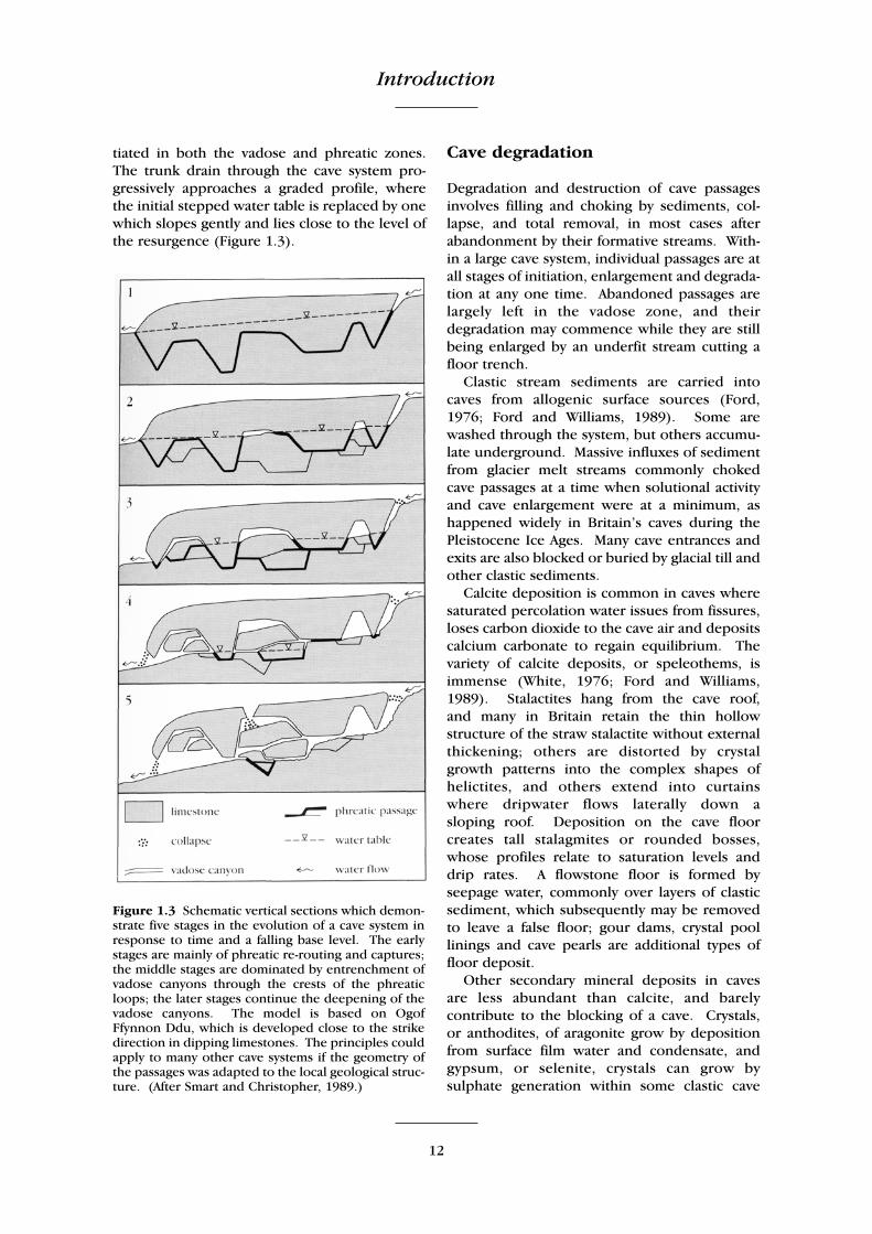
Cave systems evolve with increasing complex-ity as individual passages are abandoned infavour of new routes at lower levels. The pro-gressive abandonment is partly due to the avail-ability of new resurgences at lower sites in atopography subjected to surface lowering, but isalso due to the karst system becoming moremature. Rejuvenation may affect the whole cavesystem or just an individual passage. Phreaticup-loops are eliminated by vadose entrench-ment through their crests; down-loops arereduced by paragenesis, where the cave roof inthe trough is preferentially eroded while solu-tion of the floor is hindered by a protective coverof clastic sediment. New shorter routes are ini-
Introduction
12
tiated in both the vadose and phreatic zones.The trunk drain through the cave system pro-gressively approaches a graded profile, wherethe initial stepped water table is replaced by onewhich slopes gently and lies close to the level ofthe resurgence (Figure 1.3).
Cave degradation
Degradation and destruction of cave passagesinvolves filling and choking by sediments, col-lapse, and total removal, in most cases afterabandonment by their formative streams. With-in a large cave system, individual passages are atall stages of initiation, enlargement and degrada-tion at any one time. Abandoned passages arelargely left in the vadose zone, and theirdegradation may commence while they are stillbeing enlarged by an underfit stream cutting afloor trench.
Clastic stream sediments are carried intocaves from allogenic surface sources (Ford,1976; Ford and Williams, 1989). Some arewashed through the system, but others accumu-late underground. Massive influxes of sedimentfrom glacier melt streams commonly chokedcave passages at a time when solutional activityand cave enlargement were at a minimum, ashappened widely in Britain’s caves during thePleistocene Ice Ages. Many cave entrances andexits are also blocked or buried by glacial till andother clastic sediments.
Calcite deposition is common in caves wheresaturated percolation water issues from fissures,loses carbon dioxide to the cave air and depositscalcium carbonate to regain equilibrium. Thevariety of calcite deposits, or speleothems, isimmense (White, 1976; Ford and Williams,1989). Stalactites hang from the cave roof, and many in Britain retain the thin hollowstructure of the straw stalactite without externalthickening; others are distorted by crystalgrowth patterns into the complex shapes ofhelictites, and others extend into curtains where dripwater flows laterally down a sloping roof. Deposition on the cave floorcreates tall stalagmites or rounded bosses,whose profiles relate to saturation levels anddrip rates. A flowstone floor is formed byseepage water, commonly over layers of clasticsediment, which subsequently may be removedto leave a false floor; gour dams, crystal poollinings and cave pearls are additional types offloor deposit.
Other secondary mineral deposits in caves are less abundant than calcite, and barelycontribute to the blocking of a cave. Crystals, or anthodites, of aragonite grow by depositionfrom surface film water and condensate, andgypsum, or selenite, crystals can grow by sulphate generation within some clastic cave
Figure 1.3 Schematic vertical sections which demon-strate five stages in the evolution of a cave system inresponse to time and a falling base level. The earlystages are mainly of phreatic re-routing and captures;the middle stages are dominated by entrenchment ofvadose canyons through the crests of the phreaticloops; the later stages continue the deepening of thevadose canyons. The model is based on OgofFfynnon Ddu, which is developed close to the strikedirection in dipping limestones. The principles couldapply to many other cave systems if the geometry ofthe passages was adapted to the local geological struc-ture. (After Smart and Christopher, 1989.)

Research in limestone geomorphology
13
sediments; both these crystal forms are welldeveloped in the Llangattwg caves.
Wall and roof collapse is a widespread featurein caves; it modifies passage profiles, andcontributes to cave enlargement where fallenblocks expose new surfaces to solutional attack.Extensive collapse ultimately blocks cavepassages, because the fallen material occupieslarger volumes than the undisturbed rock. Cave roof failure occurs where the passagewidths exceed the stable span, which is dictatedby the local bed thickness and fracture density(White, 1988); the Time Machine in Daren Cilau,and other large cave passages are typified byextensive block collapse. Total failure is notcommon, and many cave boulder chokes arecomposed of inwashed debris.
A cave is totally destroyed when it is overtak-en by surface lowering. More common is thefragmentation of a cave system where surfacevalleys cut down through it, leaving truncatedpassages in their walls. The extensive caveunroofing and collapse, characteristic of the finalstage in karstic evolution, has not been reachedin Britain, mainly because of interruptions andrejuvenations due to Pleistocene climaticchanges.
RESEARCH IN LIMESTONE GEOMORPHOLOGY
Concepts and theories on the origin and devel-opment of karst landforms, above and belowground, have matured internationally, with par-allel and frequently overlapping sequences ofideas evolving in different countries. The levelof activity in scientific research in any one coun-try has been dictated in part by the extent, andtherefore the parochial relevance, of limestonekarst within the national borders; China,America and the nations which once formedYugoslavia have all been world leaders in theirtime. By comparisons with other countries,Britain has only small areas of cavernous karst(thereby excluding the distinctive chalk karst),but these include the internationally reknownedglaciokarst of the Yorkshire Dales, and they con-tain some of the world’s longest known cave sys-tems. On international scales, the level of karstresearch in Britain has probably exceeded thatwhich would be expected on the basis of theextent of its limestone outcrops, and has cer-tainly included some contributions of interna-tional significance.
Development of karst research
An early, partial understanding of the landformsand processes within karst regions evolvedprogressively as part of wider geomorphologicalresearch, and the role of solution by carbonicacid was recognized before 1800. The bench-mark studies originated from the Dinaric karst,led by Cvijic (1893, 1918) and Grund (1903,1914) who documented the critical roles ofdolines, underground drainage, caves and col-lapse in the evolution of limestone landscapes.The disorganized relief, discontinuous valleysand large closed basins were seen as the prod-ucts of solutional erosion, and the special case ofpoljes was further described by Roglic (1938).Limestone pavements are better developed inthe Alpine karsts than in the Dinaric karst, andthe classic description of their karren featuresoriginated from Switzerland (Bögli, 1960).
Parallel studies of karst landscapes in thewarmer climatic zones within China had littleinfluence on Western thought. Lehmann (1936)described the cone karst of Java, and the lime-stone landscapes of the wet Tropics were thenrecognized as extreme forms of solutional ero-sion; the tower karst of China largely remainedan enigma to Western geomorphologists untilthe political barriers to access and communica-tions were lowered in the 1970s.
Early karst research in Britain largely followedthe lead from the far greater limestone lands ofEurope, though Reid (1887) was ahead of histime when he recognized the formation of dryvalleys in the chalk during bygone periods ofperiglacial conditions. Among numerous re-gional studies of Britain’s karst, research reportsof wider significance include those concerningthe dry valleys in the Peak District (Warwick,1964), the pavements of the Yorkshire Dales(Sweeting, 1966), the depressions and valleys ofthe Mendip Hills (Ford and Stanton, 1968) andthe dolines of South Wales (Thomas, 1974).
Britain’s contributions to limestone researchwere summarized by Sweeting (1972). Modernstudies have diversified from pure geomorphol-ogy, and have emphasized research into process-es (Smith and Atkinson, 1977; Trudgill, 1985a).They have also included applied aspects of thescience, relevant to both engineering (Waltham,1989) and groundwater resources (Atkinson andSmith, 1974), and have expanded into all aspectsof karst research in the limestone terrains offoreign lands.

Introduction
14
Development of cave research
The earliest theories on cave origins sufferedfrom a shortage of geomorphological data onunderground features, and are now of only his-torical interest (Halliwell, 1974; Shaw, 1992).Archaeological excavations of near-surface cavesediments dominated cave studies in Britain inthe nineteenth century, when the origin of thecaves was largely ignored.
Cviji c (1893) recognized the role played byunderground drainage in the evolution of karsttopography, but it was Katzer (1909) and Martel(1921) who expounded the special case of karstdrainage by discrete conduits and cave passages.Subsequently, a series of American papers estab-lished contemporary understanding of cavegenesis in the English language. Davis (1930)favoured deep phreatic cave development whenhe tried to fit karst processes into his cyclicpattern of landscape evolution (Davis 1899), buthis ideas lacked a foundation of undergroundobservations. Swinnerton (1932) backed theconcept of shallow phreatic cave development,at or just below the water table, and a domi-nance of vadose cave development was postulat-ed by Gardner (1935) and Malott (1937). Bretz(1942) interpreted the features of cave mor-phology to identify early phreatic developmentand subsequent vadose development in mostcaves. Each of these authors was only partly cor-rect in his understanding of the complex initia-tion of caves and the polygenetic nature of sub-sequent cave development (Lowe, 1992c).
A hydrological approach to the environmentof cave development (Rhoades and Sinacori,1941), combined with an early concept of therole of the water table, promoted papers on thelevels of cave development (with respect to alti-tude), including studies of the Yorkshire caves bySweeting (1950) and the Mendip caves by Ford(1965b). The concept of the water table in acomplex karst aquifer was later questioned(Drew, 1966), and cave levels have been re-assessed in the light of modern knowledge byPalmer (1987).
Geological controls on the Yorkshire caveswere identified by Simpson (1935), Myers(1948), Atkinson (1963) and Waltham (1970),and were then more widely recognized as thedominant influence on cave development(Rauch and White, 1970, 1977; Waltham, 1971a).The Mendip caves were the model for a widertheory on cave development established by Ford
(1965b) and then modified to take increasingaccount of geology (Ford, 1971). Ultimately thismatured into a general theory by Ford and Ewers(1978) which respected geological guidancewithin vadose, shallow phreatic and deepphreatic environments. The special case of theevolution of maze caves was described by Palmer(1975) and related to British examples by Ryder(1975).
The essential feature of the environments,processes and controls of cave development arenow well established (Palmer, 1984, 1991; Ford,1988; White, 1988; Ford and Williams, 1989),and general theories have been reviewed byLowe (1992c). Modern cave studies are evolvingon lines beyond pure geomorphology. The ear-liest stages of cave initiation are viewed with ref-erence to the role of solution by sulphuric acid(Lowe, 1992b; Worthington and Ford, 1995).Research into the increased secondary perme-ability due to circulation of saline groundwateris based on fieldwork in submarine karstic cavesin the Bahamas, and has important implicationswith respect to hydrocarbon circulation andstorage in oil reservoirs (Smart et al., 1988a;Whitaker and Smart, 1993). Cave systems insubaerial karst regions are providing unique evi-dence of the times-scales of landscape evolution,because many of them contain the longestsequences of dated sediments – which can berelated to surface events on geomorphologicalprinciples.
Dating of cave sediments
There is no means of directly measuring the ageof a cave. As the early stages of initiation maytake millions of years, the timing of a cave’s ori-gin is arbitrary, but the main phase of enlarge-ment from a narrow fissure to a large cave pas-sage is commonly a recognizable event within itserosional history. This event cannot be dated,but any sediments within the cave must post-date the erosional enlargement, and there arevarious methods available for dating the sedi-ments (Ford and Williams, 1989; Smart andFrances, 1991).
Absolute or radiometric dating relies on meas-urement of some process which has taken placein the material at a known rate from a knownstarting level. Radiocarbon dating is based onthe decay of the unstable carbon-14 isotopesince it was trapped in a sediment at the time ofdeposition; the initial isotopic ratio is that which

British karst regions
15
is constant in the atmosphere, and the half life isknown. Dates are only reliable back to 45 000years (45 ka), so the application to cave sedi-ments is limited.
Uranium series dating is based on the decay ofunstable uranium-234 to produce thorium-230where uranium-234 is trapped in the calcite lat-tice on deposition but the daughter thorium iso-tope is absent. Thorium-230 is produced bydecay of the uranium-234, and measurement ofthe isotope ratio indicates time from the initialdeposition. If the calcite is subjected to re-solu-tion, or is contaminated by detrital thorium, thetechnique does not yield reliable ages. The nor-mal age limit for this technique is 350 ka, thougha stalagmite may be positively identified as beingolder than the limit; mass spectrometric tech-niques, and the measurement of other uraniumisotopes, can extend this limit to around 500 kain some cases. Uranium series analyses haveprovided the most numerous cave sedimentdates (Gascoyne et al., 1978; Ford and Williams,1989).
Electron spin resonance (ESR) and thermolu-minescence provide measures of the exposureof any calcite speleothem material to enviro-mental radiation. The accumulated radiationdose received by a sample is determined by lab-oratory irradiation and deterioration of the ther-moluminescence or ESR signal strength, whilein situ measurement of the site-specific radia-tion dose rates allow calculation of the sampleage. It is necessary to assume that the dose ratehas been constant since deposition, but ages upto about 900 ka can be achieved with about 15%accuracy.
Comparative dating methods rely on correla-tion of a recognizable parameter with an exter-nally calibrated chronology. Fossil and artefactrecords provide the conventional methods, buthave limited application in most caves. Palaeo-magnetic stratigraphy is based on identifying thepolarity and orientation of the natural remanentmagnetism recorded at the time of deposition byferric minerals trapped in the sediments. It canbe applied to sequences of clastic cave sedi-ments, and also to calcite speleothems that carryweaker magnetic signals from their impuritiesbut are not prone to post-depositional distur-bance (Latham et al., 1979). Sediment ages upto 2 Ma have been recorded from caves.
Determinations of cave sediment ages provideminimum ages for the cave passages in whichthey lie. Passage sequences may then be corre-
lated, by their geomorphology, with surfacepaleo-topographies, and this constitutes a pow-erful tool in the elucidation of landscape evolu-tion. Stalagmites are subaerial deposits formedin caves that are at least partially drained, andtheir positions therefore indicate the maximumelevations of the contemporary local resur-gences and valley floors; dated stalagmites pro-vide important evidence of the rates of valleyexcavation and surface lowering through muchof the Pleistocene. Speleothem sequences mayalso yield valuable information on palaeo-cli-mates, as the trace element contents and theratios of stable isotopes, notably oxygen-18, mayrelate to the temperature at the time of deposi-tion.
Radiometric cave sediment ages are conven-tionally expressed in ka, which represents thou-sands of years before the date of analysis. Onlyradiocarbon dates are expressed in years B.P.,measured before an arbitrary ‘present’ at1950 AD. All ages are defined with error bars,which are commonly around ± 5–10%, increas-ing slightly for the older material; these are allpublished in the primary records of the data, butare not included in this review. Cave sedimentdates are particularly valuable sources of geo-morphological data. Published data of majorsignificance in Britain include those referring tothe Mendip caves (Atkinson et al., 1984; Smart etal., 1988b; Farrant, 1995), the Yorkshire caves(Gascoyne et al., 1981, 1983a, b; Gascoyne andFord, 1984; Baker et al., 1995b, 1996), the PeakDistrict caves (Ford et al., 1983; Rowe et al.,1989b), caves in Devon (Proctor and Smart,1991), caves throughout Britain (Atkinson et al.,1978, 1986; Gordon et al., 1989) and caves overa wider area (Hennig et al., 1983; Baker et al.,1993).
BRITISH KARST REGIONS
Most of Britain’s caves and karst landformsoccur on the thick and strong limestones of theLower Carboniferous succession. The subma-rine palaeogeography of the Dinantian seas var-ied considerably across the area now occupiedby Britain. Consequently, there is substantial lat-eral variation within the Carboniferous succes-sion; the main limestone units in the main karstregions are correlated in outline in Figure 1.4.Most of the karst and caves are formed in themore massively bedded facies of the carbonates,which were deposited on slowly subsiding shelf,

16
Figure 1.4 The main limestone units of the Lower Carboniferous within the major karst region of Britain.Thicknesses are generalized as there are considerable lateral variations. All the limestones are Dinantian, exceptfor the Namurian Main and Great Limestones of the Pennines. In the Yorkshire Dales karst, the Great ScarLimestone is the massive carbonate facies developed in the Askrigg Block, and the Yoredale facies belongs tothe Brigantian Wensleydale Group. In South Wales the Abercriban Oolite Group includes the Blaen OnneuOolite. The main cover and basement rocks are identified; the Cefn y Fedw Sandstone extends across theBrigantian/Namurian boundary. All the named limestones are karstified to some extent, but the majorcavernous units are distinguished. (Largely after George et al., 1976; Arthurton et al., 1988; Lowe, 1989a.)

British karst regions
17
lagoonal and ramp areas. Contemporaneousclastic sediments accumulated in adjacenttroughs, and interrupted the carbonate deposi-tion when they extended over the shelf areas.
The major regions of cavernous karst aretherefore defined by the major outcrops of themassive facies of the Carboniferous limestones –in the two parts of the Yorkshire Pennines, thePeak District, the Mendip Hills and South Wales(Figure 1.2). The finest limestone landscapesand the greatest extent of cave development liein the glaciokarst of the Yorkshire Dales, formedon the thick Great Scar Limestone in the areaaround Ingleborough and Malham. The periph-eral zone of the Northern Pennines includes allthe karst on the thin Yoredale limestones, andalso on outcrops of the thinner and faultedequivalents of the Great Scar fringing the adja-cent Lake District and Morecambe Bay. Both theWhite Peak limestone area of the DerbyshirePeak District and the Mendip Hills are uplandkarsts which are clearly defined by geology andtopography. The South Wales karst is spreadalong the limestone outcrop which fringes thecoalfield syncline; it is not a conspicuous featureof the regional topography but it does containmany long, deep and important cave systems.
Each of the five main karst regions has suitesof landforms and cave systems with their owndistinctive characteristics (Table 1.1). Theregional individualities are largely imposed bythe geological structure, the relationshipsbetween geology and topography, and the localPleistocene history of fluvial, periglacial and gla-cial stages. The geomorphology of the caves inthe four main cavernous karsts have been com-prehensively reviewed in the British CaveResearch Association series of books on theLimestones and Caves of Britain (NorthwestEngland – Waltham, 1974a; Mendip – Smith,1975a; Peak District – Ford, 1977a; Wales – Ford,1989a).
Outside the main areas of CarboniferousLimestone, Britain’s karst is dominated by thelarge area of chalk outcrop (Figure 1.2); this hasa distinctive landscape of rolling downland anddry valleys, but contains very few caves. Thereare more caves in the smaller outcrops of olderlimestones, notably in North Wales, the Forest ofDean, Devon and Scotland. Individually, theselesser karst regions are often overlooked, butthey form important components of Britain’slandscape; for statistical purposes they aregrouped together in Table 1.1. The Jurassic
limestones, and other less extensive carbonates,have limited development of karst landformsand very few caves.
Karst in the Quaternary
Most of Britain’s landforms are the products oferosion and deposition during the Quaternary.The broad pattern of highlands and lowlands isa function of geological structure, with originsthat reach back to Tertiary and earlier times.There are also remnants of uplifted, deformedand dissected erosion surfaces which predatethe Pleistocene. But most individual landforms,and all the details of the landscapes, evolvedwithin the Pleistocene and Holocene – whenthe cyclic climatic variations exercised greatinfluence over the karst processes. Solutionalactivity was at a maximum during each warmphase. Conversely, it was greatly reduced inmost cold phases; it ceased completely in mostareas during periods of total ice cover, thoughglacial meltwater poured through the caves insome limestone blocks.
The main features of the later half of theQuaternary are outlined in Figure 1.5. The mostconspicuous single event was the Anglian glacia-tion in the Middle Pleistocene, during which icesheets extended across the whole of Britainnorth of a line roughly through London and theBristol Channel (Figure 1.2); glaciers covered allthe main karst regions, except for the MendipHills and the southern half of the chalk karst.Earlier and subsequent glacial advances coveredlesser areas of Britain.
Little is known of the pre-Anglian cold phases,but there is evidence for at least five stages ofglaciation in the northern parts of Britain(Bowen et al., 1986). The chronology of these isuncertain, but sediments in the Mendip cavesidentify multiple cold phases both before andafter the Matuyama/Brunhes magnetic reversal,which is dated to 780 ka (Baksi et al., 1992).The end of the Early Pleistocene is not definedwithin Britain, and is variously ascribed to the780 ka magnetic event or the base of theBeestonian (Bowen et al., 1986).
Following the Anglian glaciation, the warminterglacials of the Hoxnian and Ipswichian wereimportant periods of renewed karstic activity.Glacial tills were deposited by a limited iceadvance in northeastern England during theintervening cold stage of Oxygen Isotope Stage 6(Bowen et al., 1986). This stage is widely

18
Reg
ion
Yo
rksh
ire
Dal
es1
No
rth
ern
Pen
nin
es2
Pea
k d
istr
ict
Men
dip
Hil
lsSo
uth
Wal
esR
est
of
Bri
tain
3
Geo
logy
Kar
st a
rea4
Kar
st r
elie
f5
Lim
esto
ne
thic
knes
s6
Typ
ical
dip
Last
gla
ciat
ion
320
km2
270
m20
0 m
1° Dev
ensi
an
220
km2
70 m
40 m
1° Dev
ensi
an
420
km2
260
m40
0 m
5° Angl
ian
7
110
km2
260
m70
0 m
30°
No
ne
220
km2
330
m15
0 m
10°
Dev
ensi
an
9000
km
2 (m
ost
ly c
hal
k)20
0 m
(ch
alk)
200
m (
chal
k)V
arie
s be
twee
n a
reas
Var
ies
betw
een
are
asK
ars
t8
Gla
cio
kars
tFl
uvi
oka
rst
Inte
rstr
atal
kar
stPa
vem
ent
area
10
• •
•
677
ha
• •
613
ha
• •
• 0
• •
0•
•8
ha
• (S
cotl
and
)9
• •
(ch
alk)
28 h
a (S
cotl
and
, No
rth
Wal
es)
Dry
val
leys
Kar
st g
org
esC
olla
pse
feat
ure
s
• • •
••
• •
• •
• • •
••
• (c
hal
k)
Do
line
fiel
ds
Ep
hem
eral
lake
sPo
lygo
nal
kar
st
• •
••
• •
••
• (c
ove
red
ch
alk)
• (c
hal
k)
Fam
ous
site
sM
alh
am C
ove
Gap
ing
Gill
Hu
tto
n R
oo
f Cra
gsD
ove
Dal
ePe
ak C
aver
nC
hed
dar
Go
rge
Wo
oke
y H
ole
Dan
-yr-
Ogo
fPo
rth-
yr-O
gof
Ca
ves
Maj
or
pas
sage
typ
es
Nu
mbe
r of
cav
es11
To
tal c
ave
len
gth
11
Cav
es o
ver
1 km
lon
g
Vad
ose
join
t sh
afts
,p
hre
atic
on
bed
din
g14
2032
5 km
50
Join
t m
azes
620
65 k
m9
Phre
atic
on
vei
ns
and
bed
din
g21
050
km
9
Do
wn
dip
ph
reat
ic lo
op
s22
055
km
10
Do
wn
dip
vad
ose
, str
ike
ph
reat
ic27
019
5 km
12
Var
y be
twee
n a
reas
410
45 k
m6
Lon
gest
cav
es12
(km
)E
ase
Gill
Sys
tem
71K
ings
dal
e Sy
stem
24G
apin
g G
ill S
yste
m18
Ireb
y-N
ott
s sy
stem
12
Go
ydon
Po
t6
Kn
ock
Fel
lCav
ern
s5
Fair
y H
ole
4D
evis
Ho
le2
Peak
–Sp
eed
wel
l Sys
tem
14G
ian
ts H
ole
5B
agsh
aw C
aver
n4
Car
lsw
ark
Cav
ern
2
Swild
on
’s H
ole
9St
Cu
thbe
rt’s
Sw
alle
t7
Wo
oke
y H
ole
4G
ou
gh’s
Cav
e2
Ogo
f Ffy
nn
on
Dd
u50
Ogo
f Dra
enen
48O
gof A
gen
Allw
edd
34O
gof D
aren
Cila
u30
Slau
ghte
r C
ave
11
(Fo
rest
of D
ean
)O
gof L
lyn
Par
c 4
(N
ort
h W
ales
)U
amh
an
Cla
onai
te
3 (
Sco
tlan
d)
Ogo
f Lly
n D
u 2
(No
rth
Wal
es)
Dee
pes
t ca
ves12
(m
)E
ase
Gill
Sys
tem
211
Mer
egill
Ho
le20
6Pe
n y
gh
ent
Pot
196
Gap
ing
Gill
Sys
tem
195
Go
ydon
Po
t61
Scra
fto
n P
ot44
Pate
Ho
le33
Ayle
burn
Min
e C
ave
30
Gia
nts
Hol
e21
4M
asso
n C
aver
n19
0Pe
ak–S
pee
dw
ell S
yste
m18
4N
ettl
e Po
t18
0
Eas
twat
er C
aver
n18
0Lo
ngw
oo
d S
wal
let
175
Swild
on
’s H
ole
167
Man
or
Farm
151
Ogo
f Ffy
nn
on
Dd
u30
8O
gof D
aren
Cila
u
217
Ogo
f Age
n A
llwed
d17
7D
an-y
r-O
gof
140
Ogo
f Lly
n P
arc
115
(N
ort
h W
ales
)Sl
augh
ter
Cav
e 9
9 (
Fore
st o
f Dea
n)
Cn
oc
nan
Uam
h 9
0 (
Scot
lan
d)
Ogo
f Hes
p A
lyn
90
(Sc
otla
nd
)1
Th
e m
ain
so
uth
ern
Dal
es a
rea
on
th
e As
krig
g B
lock
, in
clu
din
g D
entd
ale
and
exc
lud
ing
Nid
der
dal
e.2
In
clu
din
g N
idd
erd
ale,
th
e ka
rst
east
of M
ore
cam
be B
ay, a
nd
th
e ea
ster
n fr
inge
of t
he
Lake
Dis
tric
t.3
Mo
stly
th
e w
eakl
y ca
vern
ou
s ka
rst
of t
he
chal
k an
d o
olit
ic li
mes
ton
es; i
ncl
udi
ng
the
cave
rno
us
kars
t o
f Dev
on
, Fo
rest
of D
ean
, No
rth
Wal
es a
nd
Sco
tlan
d.
4 A
pp
roxi
mat
e ar
ea o
f kar
stic
lan
dsc
apes
; do
es n
ot
incl
ud
e al
l th
e lim
esto
ne
ou
tcro
ps.
5 A
pp
roxi
mat
e va
lues
for
the
loca
l rel
ief w
ithi
n t
he
limes
ton
e, w
hich
dic
tate
s th
e m
axim
um
des
cen
t fr
om
sin
k to
ris
ing,
ad
ded
to
an
y d
epth
of k
arst
ifica
tio
n b
enea
th th
e re
surg
ence
leve
l.6
Geo
logi
cal d
ate
are
gen
eral
ized
for
pu
rpo
ses
of c
om
par
iso
n.
7 O
r p
oss
ibly
Wo
lsto
nia
n –
see
text
.8
Mo
st k
arst
feat
ure
s ar
e fo
un
d t
o s
om
e ex
ten
t in
all
the
mai
n k
arst
reg
ion
s, b
ut
thei
r im
po
rtan
ce is
ass
esse
d in
rel
ativ
e te
rms:
• =
sig
nifi
can
t, b
ut
min
or;
• •
=
imp
ort
ant
and
wid
esp
read
;•
• •=
inte
rnat
ion
ally
imp
ort
ant.
9 L
oca
tion
of t
he
maj
or
feat
ure
s n
oted
in p
aren
thes
es.
10
Fro
m W
ard
an
d E
van
s (1
976)
.11
Rec
ord
ed c
aves
lon
ger
or
dee
per
th
an 5
m; f
igu
res
rou
nd
ed t
o n
eare
st 1
0 ca
ves
and
5 k
m o
f pas
sage
; fro
m u
np
ubl
ish
ed d
atab
ase
of L
imes
ton
e R
esea
rch
Gro
up
, Un
iver
sity
of H
ud
der
sfie
ld.
12
Su
bjec
t to
co
nti
nu
ou
s re
visi
on, a
s le
ngt
hs
(an
d le
ss fr
equ
entl
y d
epth
s) a
re in
crea
sed
by
new
ly d
isco
vere
d p
assa
ges
or
by li
nks
fou
nd
bet
wee
n k
now
n c
aves
.
Tab
le 1
.1A
com
par
iso
n o
f th
e m
ajo
r fe
atu
res
wh
ich
giv
e th
e in
div
idu
al c
har
acte
r to
eac
h m
ain
kar
st r
egio
n o
f B
rita
in.

British karst regions
19
Figure 1.5 The major glaciations and climatic variations, stages and subdivisions, and cultural phases, of thelater parts of the Quaternary. The chronology is based on terrestrial material since about 120 ka, and on cor-relation with the earlier oxygen isotope stages in the marine sediment record. A more complex pattern of cli-matic variations is known to exist; both they and other debatable correlations are omitted. The problems of theEarly Devensian subdivisions, the ‘Wolstonian’ glaciation and the Early/Middle Pleistocene boundary arereferred to in the text. (After Imbrie et al., 1984; Bowen et al., 1986; Martinson et al., 1987; Campbell andBowen, 1989; Shackleton et al., 1990.)

Introduction
20
referred to as the Wolstonian glaciation, but theage of the sediments at the Wolston section areopen to question (Rose, 1987). The Wolstonianlabel may therefore be regarded as inappropri-ate, but it is still in use until a substitute name isaccepted for this glacial event. There is similaruncertainty over events in the Early Devensian,where the Upton Warren and Chelford inter-stadials cannot be reliably correlated with thewarm phases of 5a and 5c in the oxygen isotoperecord. Although these climatic oscillations canbe recognized and dated in cave sedimentsequences, the critical sediment profiles on thesurface cannot yet be correlated to those under-ground.
The major ice expansion of the LateDevensian extended across Scotland, north andnorth-east England and most of Wales (Figure1.2). It is referred to as the Dimlington glacia-tion, and is distinguished from the lesser LochLomond re-advance which postdates it. Boththe ice cover and the climatic change had mas-sive impacts on many of the karst landscapes.The limestone outcrops of the Yorkshire Daleswere scoured to form the basis of Britain’s finestglaciokarst. Periglacial conditions were imposedon the Peak District, Mendip Hills and most ofthe chalk karst, during which time most of themodern dry valleys were deepened by subaerialfluvial activity. The Devensian ice cover retreat-ed when the late glacial Windermere interstadialopened at about 13 ka; evidence of the warmerclimate from fossil beetles in subaerial sedi-ments (Coope, 1977; Gordon and Sutherland,1993) correlates closely with the renewed cavestalagmite growth (Gascoyne et al., 1983b;Atkinson et al., 1986). A subsequent, short, coldstage was marked by the Loch Lomond glacia-tion in the Scottish Highlands, and stalagmitegrowth recommenced in many caves only at thebeginning of the Flandrian (Gascoyne et al.,1983b). From then until the present day, solu-tional processes have been dominant in the con-tinued evolution of Britain’s karst.
THE CHOICE OF GCR SITES
The karstlands of Britain contain a great range ofsurface and underground landforms, many ofwhich are worthy of conservation in order tomaintain the integrity of the nation’s geologicalheritage. They include famous landmarks suchas Cheddar Gorge and Malham Cove, some ofwhich already receive a measure of protection
within the National Parks. They also includeremote cave passages, only ever visited by ahandful of cave explorers. Their scientific valuesdo not correspond to their fame or their accessi-bility, but they have been assessed on a nationalbasis for the purpose of the GeologicalConservation Review (GCR).
The aim of the GCR has been to compile a listof karstic landforms suitable for designation asSites of Special Scientific Interest (SSSI). Theserepresent all the important aspects of Britain’skarst, and include the sites which have scientificsignificance for both the present and the future.The criteria for selection have therefore beenany one of four factors:
1 The finest example of any particular landformor cave type, such as Cheddar Gorge, theKingsdale cave system and the pavements ofAsby Scar.
2 Unique sites, such as Malham Cove, LangcliffePot, the Pant-y-llyn turlough and Beachy HeadCave.
3 Sites important for teaching and research,such as the glaciokarst of Malham andIngleborough and the Dove Dale fluviokarst.
4 Important assemblages of landforms, such asthe Ingleborough karst and some of the moreextensive cave systems.
By these criteria in their simplest form, 22 of thesites are included as the best examples of thefeatures listed in Table 1.2. The values of thesites in the secondary listings of Table 1.2 are notdiminished, as many are the best examples ofimportant sub-types; the dolines of Wurt Pit,Sandpit and High Mark have structures and ori-gins that are totally different from each otherand from those of Ingleborough. There are alsomany local features of the geology which defineimportant contrasts between the karst landformsof the different regions; geological controls areparticularly conspicuous in the morphology ofcaves, and sites are included in the GCR to estab-lish the regional characteristics.
Among the karst landforms, the cave systemsand the limestone pavements constitute specialcases with regard to their needs of conservation(Glasser and Barber, 1995; Webb, 1995; Bennetet al., 1995).
Beside their values to karst geomorphology,many caves have great importance and value inthe stratigraphy of the sediments that they con-tain. In erosional upland environments, caves

The choice of GCR sites
21
constitute unique preservation sites where sedi-ments can accumulate in stable conditions andremain safe from destruction by continued sur-face denudation. The value of these sedimentsis enhanced by the climatic sensitivity of solutionprocesses and karst hydrology, and also by thechronological record that is deduced from theirradiometric dating. The cave sediments providea record of events with implications for researchinto the evolution of landscapes far beyond theconfines of the karst. Many of the known cavesediment sequences have not yet been studiedin detail, but as a data source for Pleistoceneresearch, caves have unparalleled value.Remnants of sediments can survive in so manyobscure corners of cave systems that a large pro-portion of caves could be considered as scientif-ic resources worthy of conservation. Not everysite can be sensibly protected, but this factor hasbeen taken into account in the selection of GCRsites, which therefore include the most impor-tant known cave sediment sequences.
Limestone pavements form a special case for
conservation because of their sensitivity to rapidand total destruction under the guise of smallscale stone extraction. The solutionally frettedclints forming the surface layer of many pave-ments have been in demand as a wierd form ofdecorative stone, and many areas of very finenatural rock outcrop have been destroyed in thepast. The pavements of the Yorkshire Dales andNorthern Pennines are of international repute,and are also of very special botanical value (Wardand Evans, 1976). The more important sites aredesignated as SSSIs, and separate protectionmeasures have been created for many othervaluable sites which cannot be included in theGCR (Webb, 1995).
The list of sites in the GCR can never be takenas a complete citation of Britain’s karst geomor-phology. New discoveries underground, andnew research results from above and belowground, continually add to the geomorphologi-cal record. Three potential GCR sites have beenidentified during the documentation phase. Theimportance of Slaughter Stream Cave and Ogof
Feature Prime example Important examplesLimestone karstDolinesDry valleyKarst gorgeCollapsed caveLimestone pavementGlaciokarstFluviokarstPolygonal karstInterstratal karstFossil karst
Ingleborough karstLathkill DaleCheddar GorgePenyghent GillGreat Asby ScarMalham and GordaleManifold ValleyHigh MarkMynydd LlangynidrGreen Lane Pits
Wurt Pit, Sandpit, High MarkCave Dale, Conistone, Malham and GordaleMalham and Gordale, Hell Gill, WinnatsGod’s Bridge, Porth-yr-OgofScales Moor, Ingleborough, Gait BarrowsIngleborough, TraligillLathkill Dale, Dove DaleBrimble and CrossDraenen, Nidderdale, LlangattwgMasson Hill, Pikedaw
Limestone cavesDeep phreaticShallow phreaticAbandoned phreatic
Maze caveVadose canyonsVadose shaftsCalcite depositsDated sediments
Wookey HoleKingsdale CavesDan-yr-Ogof
Knock Fell CavernsEase Gill CavesIngleborough cavesOtter HoleCharterhouse caves
Ease Gill, CheddarIngleboroughAlyn Gorge, Ingleborough, Castleton,Llangattwg, Minera, Priddy, Sleets GillMossdale and Langcliffe, Hale MossOgof Ffynnon Ddu, CastletonEase Gill, Brants Gill, ButtertubsSt Dunstan’s, Boreham, Dan-yr-OgofCheddar, Traligill, Ease Gill
Chalk karstDolinesDry valleysCave
Cull-pepper’s DishMillington PasturesBeachy Head Cave
Devil’s Punchbowl, Castle Lime QuarryManger, Devil’s DykeWater End
Salt karstSubsidence Moston Long Flash Rostherne
Table 1.2 The finest examples of individual karst and cave features within the GCR sites of Britain. The listingof features is in the order of their description in Chapter 1. The tabulated data are recognized as being sub-jective, especially among the important secondary examples which are not presented in any sequence of meritand are referred to be short versions of their full site titles.

Introduction
22
Draenen were recognised when cavers removedsediment chokes from the entrances, and ineach case discovered many kilometres of cavepassage that have considerable geomorphologi-cal importance. Helbeck Scars is also a potentialGCR site, reflecting the improving perception ofthe values of the limestone pavements in thewilder areas of the Pennines. These three sitesare proposed for SSSI status, but have not beendesignated at the time of writing.
This volume of the GCR embraces the variousaspects of karst geomorphology, but there aresome notable omissions. Many cave entrancesor passages with immediate access from the sur-face have been used as animal lairs or havebecome natural pitfall traps. These bone caveshave therefore accumulated valuable records ofpast faunas (Stuart, 1983; Andrews, 1990;Simms, 1994), but their importance is toPleistocene palaeontology rather than karst geo-morphology. Some famous British cave sites,including Victoria Cave, Kirkdale Cave, CreswellCrags, Minchin Hole and Kent’s Cavern, aretherefore excluded from this volume, but aredescribed in other parts of the GCR. Similarly,the major tufa deposits of Caerwys are of karsticsignificance, but are included with thePleistocene sites of Wales. Many small caves areprotected because they are important bat roosts,but they are not included in this review of thegeomorphologically valuable sites. Britain doeshave some areas of gypsum karst, worthy of geo-morphological study, but the subsiding dolinesof the Ripon area are currently of more signifi-cance to the construction industry, and are notincluded in the GCR.
The GCR karst and cave sites are distributed
across most of the country (Figure 1.6). Thestructure adopted in this volume is to documentthe karst and caves of each main limestoneregion within their own chapter, covered byChapters 2 to 6. The lesser karst regions arereviewed, and their more important sites aredescribed in Chapter 7, except for the Scottishkarst (reviewed in Chapter 8) and the NorthWales karst (included in Chapter 6).
Figure 1.6 Key map showing the coverage of locationmaps in each chapter, identified by their figure num-bers, and also the location of sites which are docu-mented in the text but fall outside the chapter loca-tion maps.