
KARNATAKA
37
UPOR PROJECT – URBAN PROPERTY OWNERSHIP RECORDS PROJECT KARNATAKA
-
Upload
wesley-rush -
Category
Documents
-
view
24 -
download
0
description
UPOR Project – Urban property ownership records project. KARNATAKA. Why PR Card. UPOR card for Urban Property is similar to RTC for agricultural property. In UPOR property records are contains both spatial and non-spatial details. - PowerPoint PPT Presentation
Transcript of KARNATAKA

UPOR PROJECT – URBAN
PROPERTY OWNERSHIP
RECORDS PROJECT
KARNATAKA
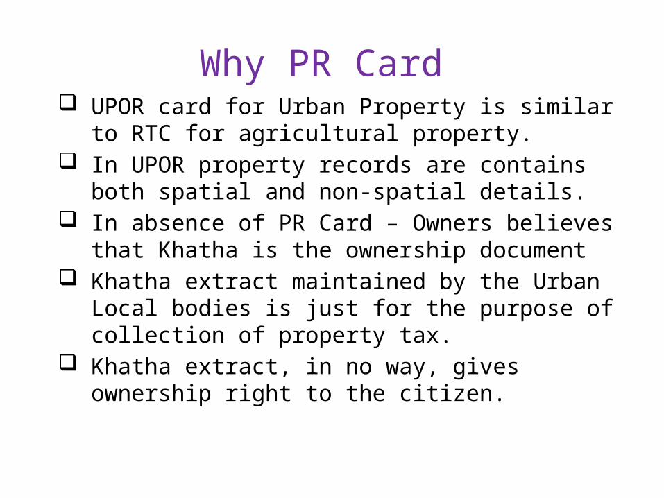
Why PR Card UPOR card for Urban Property is similar
to RTC for agricultural property. In UPOR property records are contains
both spatial and non-spatial details. In absence of PR Card – Owners believes
that Khatha is the ownership document Khatha extract maintained by the Urban
Local bodies is just for the purpose of collection of property tax.
Khatha extract, in no way, gives ownership right to the citizen.

Different Types of records (13)• Gramathana
• Urban Develoment Authority
• Layouts developed by private persons
• Alienated land but layout not approved
• Revenue sites
• Karnataka Housing Board
• Slum Board
• Allotted by local bodies
• Karnataka industrial area development board
• Private Housing Co-operative Societies
• Government Land With Survey Number
• Government Land Without Survey Number
• Agriculture Land

About UPOR Department of SSLR has taken up UPOR project
Mysore, Shimoga, Hubli-Dharwad, Mangalore, Bellary.
National Tender was floated and work started in December 2009.
Ownership documents for Urban Properties are created and maintained by SSLR department as per the provisions of KLR Act and Rules under City Survey wing.
UPOR is revised model of earlier City Survey – existing from last 100 years

Vendors Selected Name of the
City
Name of the Service Provider and Technical Service
Provider
Mysore M/s. Secon Pvt Ltd
MangaloreM/s Infotech Enterprises Ltd, Hyderabad
(After retendering work started in May 2012)
Hubli DharwadM/s. CMS Computers Ltd & Navyuga Spatial Technologies
Pvt. Ltd
Shimoga M/s. Infotech Geospatial Ltd & HCL Infosystems Ltd
Bellary ****M/s. Navayuga Infotech Pvt. Ltd & MapWorld Technologies
Ltd
Technical Service Provider -
M/s Infotech Enterprises Ltd, Hyderabad
***** Work in Bellary stopped due to poor performance of Service Provider.
Retendering has to be done for Bellary Town.

Why PR Card Property Cards, will be issued to the citizens
clearly mentioning their ownership rights on the property.
UPOR Card is a better legal document for urban properties like RTC for rural properties.
PR card is recognized under law and has a presumptive value under the Karnataka Land Revenue Act.
PR card has very accurate map of the property along with its coordinates
PR card is a single document covering rights, liabilities, privileges, accurate location and dimension of a property.

UPOR – Salient features PPP Model
• Department is funding a part of the project cost, • Vendor (s) will fund part of the cost of the project. • Vendor (s) would recover this cost only through delivery of
services to citizens – by selling P R Cards to owners
PPP Model needed for Project funding and execution,
• First time spatial data creation, creation of IT
infrastructure and for Operation of Citizen Service Centers
Department continues to discharge its core responsibility• Jointly create spatial records along with Vendor• Conduct title enquiry• Approve any change in the property record

UPOR Project Stages Creation of control network & preparation of Index map -
• Establishing of PCP, SCP &TCP• Geo-referencing of village map & Hissas incorporation
Measurement and mapping of properties: • Notice serving; Property corners marking; Photographs of
property; Measurement with ETS; Collection of Documents of ownership; detailed mapping; data entry of non-spatial data.
Title enquiry process- only by department • Specially developed software; exception reports help in
deciding ownership.
Delivery of Services• Sale of PR Card, Mutation, Sub-divisions, Information services
to other departments, Banks and Courts
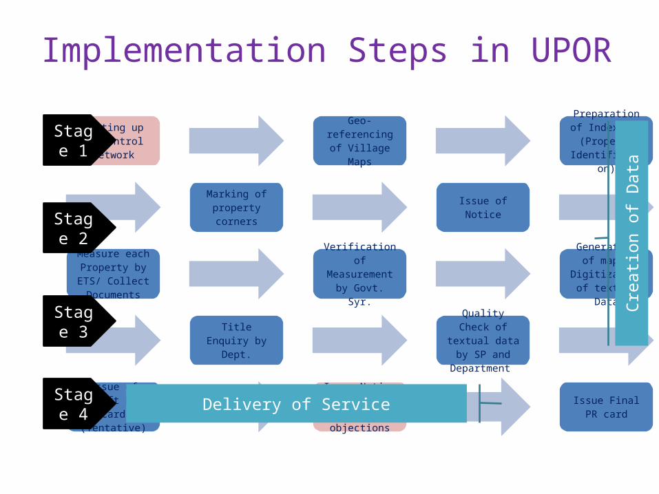
Implementation Steps in UPOR
Setting up of control Network
Geo-referencing of Village Maps
Preparation of Index Map (Property
Identification)
Issue of NoticeMarking of property corners
Measure each Property by ETS/
Collect Documents
Verification of Measurement by
Govt. Syr.
Generation of map / Digitization
of textual Data
Quality Check of textual data by SP and Department
Title Enquiry by Dept.
Issue of Draft PR Card (Tentative)
Issue Notice & Invite public objections
Issue Final PR card
Stage 1
Stage 2
Stage 3
Crea
tion
of D
ata
Delivery of ServiceStage 4

Control Network
Control Network is the first activity in any modern day
cadastral survey
Control Network helps in re-fixation of property boundaries
with lesser time, efforts and with same accuracy.
Three levels of densification (PCP, SCP and TCP)
Control Network ensures the area of survey is within the
jurisdiction
Proper Control Network alone ensures required accuracy in
survey.


Geo-referencing of village maps
All village maps are digitized The maps are geo-referenced using DGPS All hissas are incorporated in the geo-referenced village
map The geo-referenced village maps are super-imposed on
UPOR maps (after detailed mapping is completed) The boundary of government survey numbers and
alienated survey numbers are marked in these village maps
Old Gramathana Areas are also mapped and superimposed over outer boundary of gramathana as per village map
Existing CTS areas in some town and Gramathana again covered under UPOR to have digital records and seamless data with global coordinates.

Index Mapping
City is divided into Zones, Sectors, Blocks and Plots
Corner points of Properties in block and road junctions are
marked, ETS readings taken and block maps are generated
Properties are counted and approximately marked in block
map and given temporary IDs termed as Chalta No. (This is
not final id)
Property numbering and corner ids are marked on Index
Map
Index Map is validated and approved by department

Serving of Notice
Pre-printed Notice personally served by SP to property owners / occupants
For being present at the time of measurement & submission of documents
List of required documents pre-printed on notice
Data such as door no., khatha no., address, property type & usage collected from site
Office copy of notices are maintained

Marking of Property Corners Identified by department
surveyors & marked by SP in his presence
Marking by paint / wooden pegs for vacant sites
Marking is done in presence of owners/occupants
In case of disputes by neighbours on marking of boundary - Resolved by Enquiry Officers Unresolved cases are decided
during enquiry process Adjoining properties mapped as
single block Guidelines and circulars for
marking of properties issued by department

Measurement of Properties Each and every Property is
measured by Service Provider No measurement without
marking ETS used for measurement Both plot and building corner
points are measured Everyday’s data is downloaded
and map generated on the same day
Photographs of all properties are also captured by SP operators

Collection of Documents
Photo copies collected onsite from property owners/occupants by SP Operators
Documents are also collected at citizen service centers
Mobile units deployed for copying of documents onsite as & when required
Documents maintained in separate SI files created for every property
Files are kept block wise in record rooms

Validation of Measurements Validation of measurements
by Government Surveyors Concurrent Sector-wise (Post-facto)
Validation by using ETS/Tape In case error cases exceed
10% of total, SP is asked to re-measure the entire sector
Second level of validation through system during title enquiry process
More than 5% variation* cases logged for re-verification in the field
*Variation between measured extent and extent indicated in document
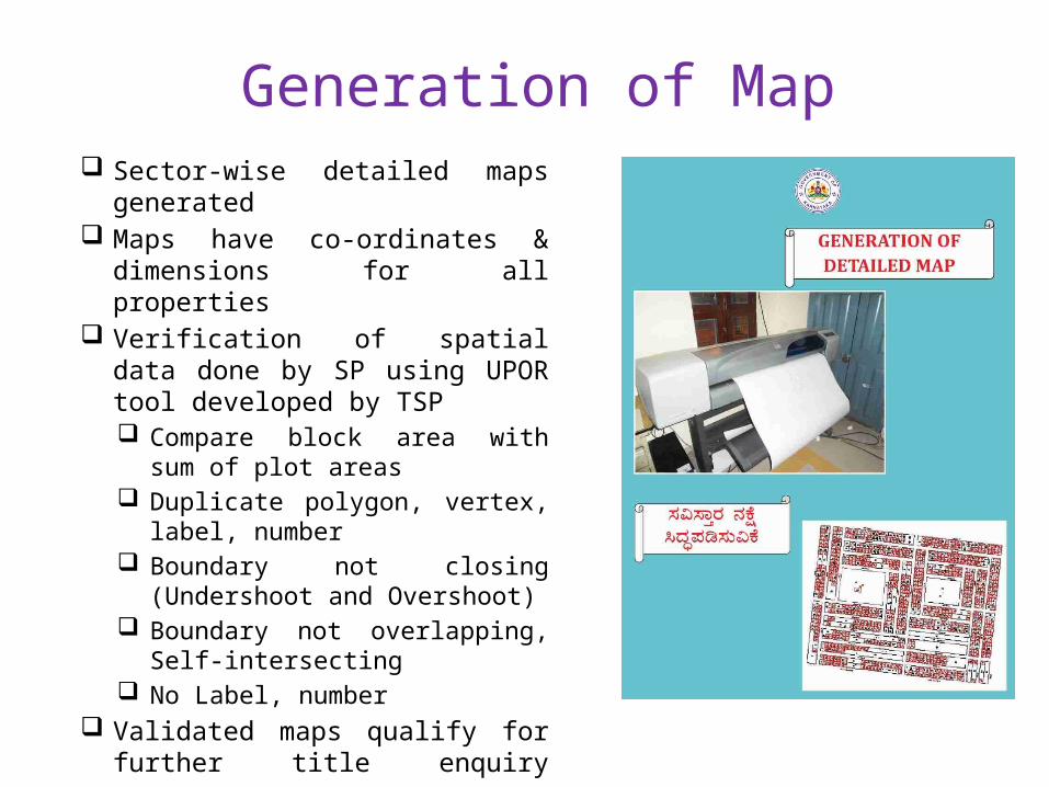
Generation of Map Sector-wise detailed maps
generated Maps have co-ordinates &
dimensions for all properties Verification of spatial data done
by SP using UPOR tool developed by TSP Compare block area with sum
of plot areas Duplicate polygon, vertex,
label, number Boundary not closing
(Undershoot and Overshoot) Boundary not overlapping, Self-
intersecting No Label, number
Validated maps qualify for further title enquiry process

Index Map and Detailed Map
Index Map before measurement
Detailed Map after measurement
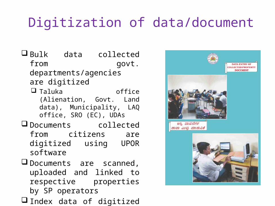
Digitization of data/document
Bulk data collected from govt. departments/agencies are digitized Taluka office (Alienation, Govt.
Land data), Municipality, LAQ office, SRO (EC), UDAs
Documents collected from citizens are digitized using UPOR software
Documents are scanned, uploaded and linked to respective properties by SP operators
Index data of digitized documents are maintained in the system
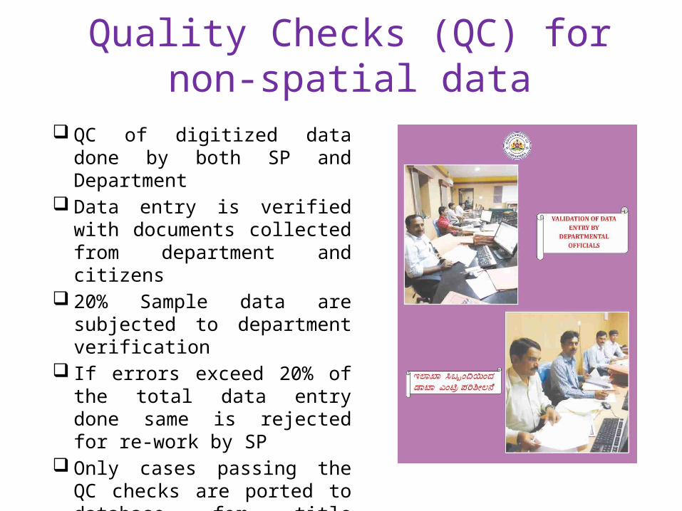
Quality Checks (QC) for non-spatial data
QC of digitized data done by both SP and Department
Data entry is verified with documents collected from department and citizens
20% Sample data are subjected to department verification
If errors exceed 20% of the total data entry done same is rejected for re-work by SP
Only cases passing the QC checks are ported to database for title enquiry process

Title Enquiry by Department
Title enquiry by department officials Three User-levels in work-flow Govt. Surveyor , Survey Supervisor, Enquiry Officers Legal documents submitted by citizens and UPOR maps are checked during title enquiry UPOR software used for title enquiry and generation of PR Card
Following checks are done during title enquiry: Ownership by tracing link to revenue survey number (except for UDA properties) Dimensions and area Name Mismatch Whether falls in government land Whether alienated In case of disputes received during title enquiry hearing is conducted by the Enquiry
Officers by following the procedure laid out in the KLR Act 1964.
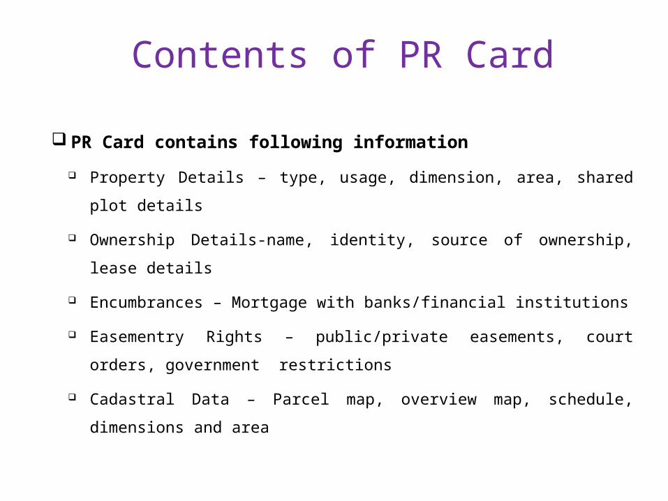
Contents of PR Card
PR Card contains following information
Property Details – type, usage, dimension, area, shared plot
details
Ownership Details-name, identity, source of ownership, lease
details
Encumbrances – Mortgage with banks/financial institutions
Easementry Rights – public/private easements, court orders,
government restrictions
Cadastral Data – Parcel map, overview map, schedule,
dimensions and area

Format of Detailed PR Card

Format of Detailed PR Card

Format of Detailed PR Card

Format of Summary PR Card

Issue of Draft PR cards (tentative)
PR Cards are not generated for properties with insufficient documents and properties having disputes
After title enquiry unique Cadastral No. and UPOR No. is generated for every property
Draft PR Cards generated after 3 level checks under title enquiry by department officers
Draft PR cards are distributed by SP OperatorsNotice served with draft PR Card and
acknowledgement taken - calling for objections to be filed within 30 days
Objections decided by Enquiry Officers of the department

Generation of Final PR Card
PR cards are finalized if no objections
are received
PR cards are digitally signed and
printed on Secured Stationary
With Barcode, watermark, hologram
and anti-copy features
Issued to owners after compulsory
enrolment – Biometric captured
Issued at citizen service centers on
payment of user charges which
varies between Rs. 300-1000
depending on property size and
usage.
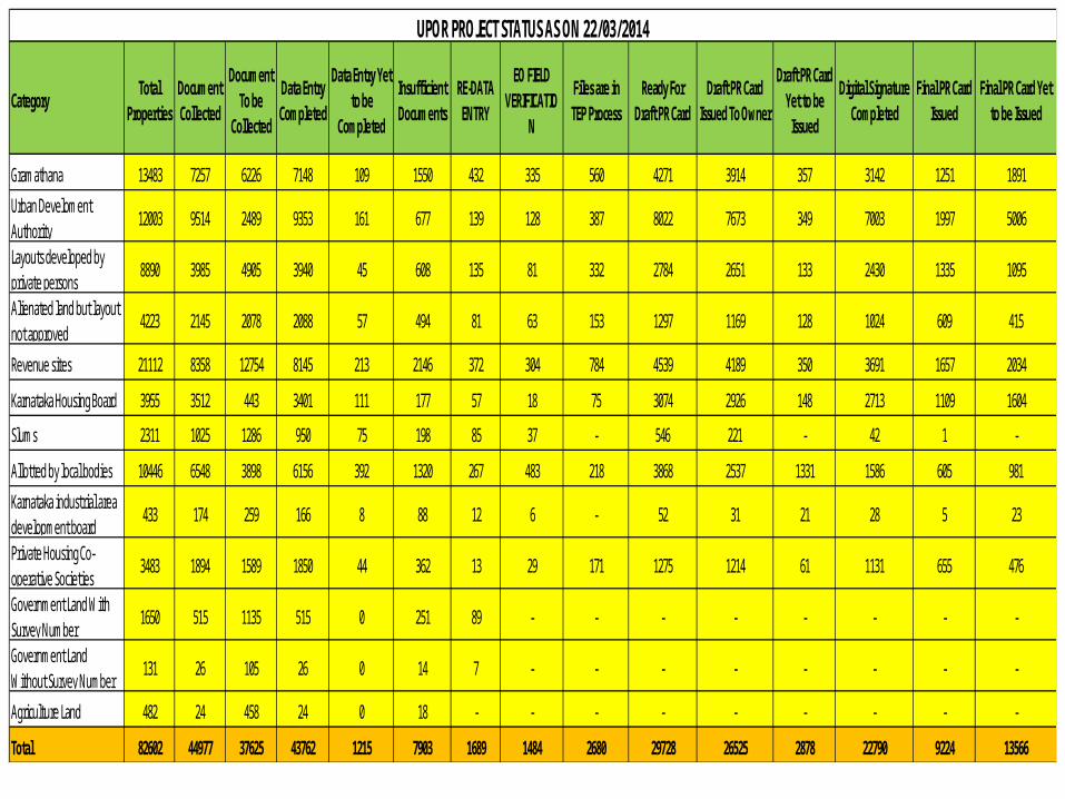
CategoryTotal
PropertiesDocument Collected
Document To be
Collected
Data Entry Completed
Data Entry Yet to be
Completed
Insufficient Documents
RE-DATA ENTRY
EO FIELD VERIFICATIO
N
Files are in TEP Process
Ready For Draft PR Card
Draft PR Card Issued To Owner
Draft PR Card Yet to be
Issued
Digital Signature Completed
Final PR Card Issued
Final PR Card Yet to be Issued
Gramathana 13483 7257 6226 7148 109 1550 432 335 560 4271 3914 357 3142 1251 1891
Urban Develoment Authority
12003 9514 2489 9353 161 677 139 128 387 8022 7673 349 7003 1997 5006
Layouts developed by private persons
8890 3985 4905 3940 45 608 135 81 332 2784 2651 133 2430 1335 1095
Alienated land but layout not approved
4223 2145 2078 2088 57 494 81 63 153 1297 1169 128 1024 609 415
Revenue sites 21112 8358 12754 8145 213 2146 372 304 784 4539 4189 350 3691 1657 2034
Karnataka Housing Board 3955 3512 443 3401 111 177 57 18 75 3074 2926 148 2713 1109 1604
Slums 2311 1025 1286 950 75 198 85 37 - 546 221 - 42 1 -
Allotted by local bodies 10446 6548 3898 6156 392 1320 267 483 218 3868 2537 1331 1586 605 981
Karnataka industrial area development board
433 174 259 166 8 88 12 6 - 52 31 21 28 5 23
Private Housing Co-operative Societies
3483 1894 1589 1850 44 362 13 29 171 1275 1214 61 1131 655 476
Government Land With Survey Number
1650 515 1135 515 0 251 89 - - - - - - - -
Government Land Without Survey Number
131 26 105 26 0 14 7 - - - - - - - -
Agriculture Land 482 24 458 24 0 18 - - - - - - - - -
Total 82602 44977 37625 43762 1215 7903 1689 1484 2680 29728 26525 2878 22790 9224 13566
UPOR PROJECT STATUS AS ON 22/03/2014

Model for recovering user charges
Property Record
The cost of creation of the property record will be
recovered from the property owner
Price of the property record will be based on• Size of the plot Area• Type of property residential / commercial• Built up Area
Cost of Property Record for Economically Weaker
Sections will be subsidized

Benefits from UPOR Project
Property owners holding genuine titles to property will be
assured of their ownership
Prospective buyers of properties will be assured of the
genuineness of the property offered for sale and all
encumbrances are systematically recorded
Banks will be sure of lending money against property• Consultation held with Banks & RBI ; Banks enthusiastic
about the Project
The Urban local bodies will have a comprehensive
database of all properties in their cities
Ensuring use of Property Records
All changes to the property will be through the property
records database
• for e.g. if a person has mortgage or leased his property,
the same will be indicated in the property record
The Registration department will only register transactions for
those properties that exist on the Urban Property Records
system.
• Legal Mechanism for this exists
Survey Department will make efforts for Banks to insist on
Property Record of Urban Property Records system prior to
giving any loan
SP Issues - Shimoga UPOR cards are made mandatory for
registration purposes from 1st May 2014[ RD 26 Munosa 2013 dated 13-02-2014] The same is deferred due to following : – Linking of Municipal khatha with UPOR
chaltha –Measurement of peripheral properties in
new layouts. –Measurement of Slum Properties. – Issuing DPR to NAL properties

TSP Issues
Linking of UPOR and Kaveri of Registration Department.
Development of Mutation Module and One time Correction module
Training to SRO staff on software developed for the purpose of UPOR card being made mandatory.

THANK YOU


![THE KARNATAKA SOUHARDA SAHAKARI ACT 1997souharda.coop/download/Act English.pdfTHE KARNATAKA SOUHARDA SAHAKARI ACT 1997 [Karnataka Act No. 17 of 2000] (With all amendments of Karnataka](https://static.fdocuments.us/doc/165x107/5ad3cc9d7f8b9a0f198e1caa/the-karnataka-souharda-sahakari-act-englishpdfthe-karnataka-souharda-sahakari-act.jpg)


