Kano vaccine direct delivery
11
ArcMeeting Week 38 By: Owolabi Kazeem.k & Nicolas Gignac
-
Upload
kazeem-owolabi -
Category
Healthcare
-
view
154 -
download
0
Transcript of Kano vaccine direct delivery

ArcMeeting
Week 38By: Owolabi Kazeem.k
& Nicolas Gignac

2014 © eHealth Africa, All Rights Reserved.
ROUTINGKANO VACCINE DIRECT
DELEVIRY

Presentation Title; RoutingPROJECT TITLE; Kano Vaccine Direct Delivery
Background & Insights
STRATEGY AND CONSIDERATIONS
OSM: OSM base map and OSRM was used for the routing
Routing: EOC serves as the start point, routing was based on proximity and FIFO, which is
used to determine cluster and drops for a particular date within a time zone (9am-11am,11am-
1pm,1pm-3pm) . Batch Routing by Nicholas.
Historical Data: There are no historical data on roads hence the travel time was pegged at
60km/h to count for traffic jam, bad roads, check points, rain, etc.
Cascade maps: This are maps that shows parent and child facilities, service & coverage
areas, supply method and frequency.
Driver’s Training: Drivers were trained on usage of mobile apps for routing and data
collection. (osmand, GPS Essentials, My tracks, Google Maps)
1
GIS Support to provide logistics support through mapping and
batch routing for 328 facilities in 300 wards in 30 LGAs in Kano
State to ensure routine immunizations at the points of service

Presentation Title; RoutingPROJECT TITLE; Kano Vaccine Direct Delivery
Routing
Algorithms Classification
Static/Dynamic
Global / Decentralized Information
A* Searching algorithms Administrative Distance
Dijkstra’s algorithms Distance Vector Routing
Multipath Routing Hierarchical State Routing
Floyd Warshall algorithms Suurballe’s algorithms
2
Definition, Delivery Semantics, Algorithms
Selecting the minimum cost, distance, and/or time path from several alternatives
for a good or message to reach its destination.

Presentation Title; RoutingPROJECT TITLE; Kano Vaccine Direct Delivery
Routing
3
QGIS; Cluster; Drops; Time Zone.
.
https://docs.google.com/a/ehealthnigeria.org/spreadsheets/d/1ALlGojTs9HztRUHUW0gFaV64HZ2vt3TsKBYIDKEuupA/edit#gid=1265600070

Presentation Title; RoutingPROJECT TITLE; Kano Vaccine Direct Delivery
Cascade Mapping
4
Analysis of the Cascade Network in practice• 80% of DDF are informal stores to CF, a third of which are in wards other than their own
• 32% of CF lie in wards other than their DDF Parent’s ward
• 90% of CF fall beyond a 2km radial service zone of its parent and 70% fall beyond a 4km radial delivery zone

Presentation Title; RoutingPROJECT TITLE; Kano Vaccine Direct Delivery
Hands on
5
Manual Routing – Kazeem Batching Routing - Nicolas
Presentation Title; RoutingPROJECT TITLE; Kano Vaccine Direct Delivery
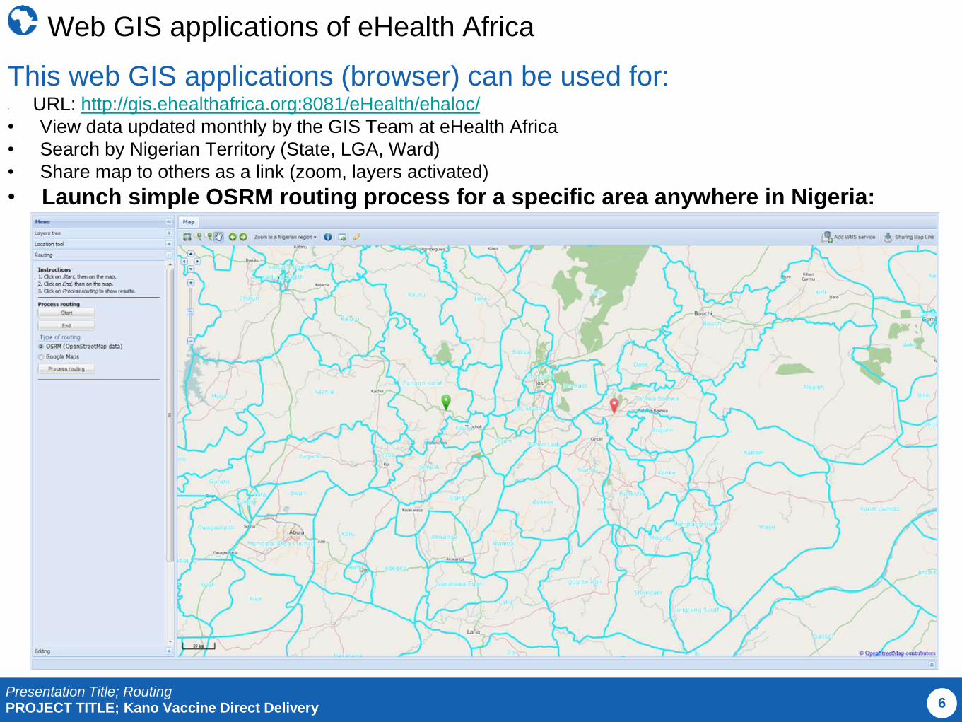
Web GIS applications of eHealth Africa
6
This web GIS applications (browser) can be used for:• URL: http://gis.ehealthafrica.org:8081/eHealth/ehaloc/
• View data updated monthly by the GIS Team at eHealth Africa
• Search by Nigerian Territory (State, LGA, Ward)
• Share map to others as a link (zoom, layers activated)
• Launch simple OSRM routing process for a specific area anywhere in Nigeria:

Presentation Title; RoutingPROJECT TITLE; Kano Vaccine Direct Delivery
Acknowledgements
Web Linkshttp://en.wikipedia.org/wiki/Category:Routing_algorithms
http://www.osgeo.org/node/1076
http://qgis-tutorials.mangomap.com/
RefrencesDr. Dheeraj Sanghi
Kurose and Ross, Based on Computer Networking, 4th edition
Wikipedia
6
Thankyou

Presentation Title; RoutingPROJECT TITLE; Kano Vaccine Direct Delivery
Discussions, Comments and Questions, etc.
7

• OSM: OSM base map and OSRM was used for the routing
• Scheduling: EOC serves as the start point, routing was based on proximity and FIFO, which is used to determine
cluster and drops for a particular date within a time zone (9am-11am,11am-1pm,1pm-3pm) to be delivered by a driver.
• Routing: It is based on proximity of health facilities to each other using road network
• Historical Data: There are no historical data on roads hence the travel time was pegged at 60km/h to count for traffic
jam, bad roads, check points, rain, etc.
• Cascade maps: This are maps that shows parent and child facilities, service & coverage areas, supply method and
frequency.
• Drivers Training: Drivers were trained on use of mobile apps for routing and data collection. (osmand, GPS Essentials,
My tracks, Google Maps