
JUNE 2019 QUARTERLY REPORT For personal use only · 7/18/2019 · Figure 5: HeliTEM Ch15 B-field...
19
ASX ANNOUNCEMENT 18 July 2019 Level 9 BGC Centre The Esplanade PERTH WA 6000 tel +61 8 9322 6322 fax +61 8 9322 6558 email [email protected] ABN 57 153 144 211 constellationresources.com.au JUNE 2019 QUARTERLY REPORT Constellation Resources Limited (“Constellation” or “Company”) is pleased to present its Quarterly Report for the period ended 30 June 2019. Highlights • The Company holds an interest in several tenements in the Fraser Range which are prospective for Nickel and are referred to as the Orpheus Project (see Figure 1 below). • The Company has completed the following work program for the June quarter: o A targeted RC drilling program in the Fraser Range over a gold target within tenement E63/1282. No significant intercepts were recorded. • Following this initial drilling program, the Company intends in the September 2019 quarter to continue preparations for a targeted drilling program to test for nickel mineralisation on E63/1281. Figure 1: Tenement Plan – Orpheus Project The Company is well funded with cash at bank of $5.6 million and is focussed on creating value from the Orpheus Project, in addition to identifying and evaluating new opportunities in the resource sector which have the potential to build shareholder value. For further information, please contact: Peter Woodman Managing Director Tel: +61 8 9322 6322 For personal use only
Transcript of JUNE 2019 QUARTERLY REPORT For personal use only · 7/18/2019 · Figure 5: HeliTEM Ch15 B-field...

ASX ANNOUNCEMENT 18 July 2019
Level 9 BGC Centre The Esplanade PERTH WA 6000
tel +61 8 9322 6322 fax +61 8 9322 6558 email [email protected] ABN 57 153 144 211
constellationresources.com.au
JUNE 2019 QUARTERLY REPORT
Constellation Resources Limited (“Constellation” or “Company”) is pleased to present its Quarterly Report for
the period ended 30 June 2019.
Highlights
• The Company holds an interest in several tenements in the Fraser Range which are prospective for Nickel and
are referred to as the Orpheus Project (see Figure 1 below).
• The Company has completed the following work program for the June quarter:
o A targeted RC drilling program in the Fraser Range over a gold target within tenement E63/1282. No
significant intercepts were recorded.
• Following this initial drilling program, the Company intends in the September 2019 quarter to continue
preparations for a targeted drilling program to test for nickel mineralisation on E63/1281.
Figure 1: Tenement Plan – Orpheus Project
The Company is well funded with cash at bank of $5.6 million and is focussed on creating value from the Orpheus
Project, in addition to identifying and evaluating new opportunities in the resource sector which have the potential
to build shareholder value.
For further information, please contact:
Peter Woodman
Managing Director
Tel: +61 8 9322 6322
For
per
sona
l use
onl
y

18 July 2019
constellationresources.com.au
Page 2 of 15
Orpheus Project
Constellation manages the Orpheus Project, which comprises five tenements covering approximately 552km² in a
prospective portion of the Fraser Range province of Western Australia. The Fraser Range province is considered
prospective for nickel, copper and gold, and has attracted significant exploration since the discovery of the Nova
deposit in 2012.
The Orpheus Project includes a 70% interest in three mineral exploration licences and one mineral exploration
licence application, and a 100% interest in a further mineral exploration licence. The three EL’s form part of a joint
venture between Constellation Resources Limited (70%) and Enterprise Metals Limited (30%, ASX: ENT).
Recent Work Programs: A targeted program of RC drilling during May/June tested a historic gold soil anomaly.
Ground electromagnetic (EM) surveys conducted during February 2019 covered the various nickel targets
mentioned in the previous quarterly reports over tenement E63/1281.
E63/1282-Gold
A RC drilling program has been completed at the Orpheus Project in the Fraser Range by Constellation Resources
Limited during May/June over a gold target within tenement E63/1282.
The drilling was aimed at testing a 3km long low-level gold in soil anomaly with a peak value of 27ppb Au coincident
with NE-SW trending magnetics. The majority of the RC drilling was focussed over a coherent 350m x 150m gold in
soil geochem zone (see Figure 2 below).
A total of 25 RC drill holes were drilled for 2,370 metres to test the gold in soil gold anomalies. Drilling was
completed on lines spaced 100-200m along strike with drill holes spaced at 30m intervals across strike (on some
lines up to 60 metres apart). Drill holes ranged in depth from 60 to 108 metres to ensure fresh rock was encountered.
Samples were collected via cone splitter on a 1 metre basis and 4 metre composites were analysed at Min Analytical
laboratories for a multi-element suite comprising Ag, As, Au, Bi, Co, Cu, Mo, Ni, Pb, Sb, Te, W and Zn.
RC drilling has shown that the gold in soil geochem anomaly area geology comprises up to 20 metres of transported
clays and gravels and deep weathering to an average depth of 50 metres. The bedrock lithological package is
dominated by an intercalated quartz-bioitite/mica garnet gneiss and chlorite-magnetite amphibolite. In addition,
occasional chert and BIF lithologies were logged. The amphibolite unit is extremely chloritic and has weak to strong
magnetite content. The gneiss can be massive to banded with quartz rich augens and in places displays silica
alteration.
The target is believed to have been adequately tested and no further work is currently planned here.
Anomalous gold values have been returned from three drill holes and are tabled below:
Drill Hole ID East North From To Grade
Au ppb Lithology
FRRC008 492522 6470500 60 64 189 Limonitic amphibolite
FRRC018 492729 6470697 84 88 142 quartz-mica-garnet gneiss
FRRC024 491425 6469799 52 56 94 garnet-quartz-mica gneiss
For
per
sona
l use
onl
y

18 July 2019
constellationresources.com.au
Page 3 of 15
Figure 2: Gold in soil results from December 2017 survey on Satellite image - E28_1282 Gold target.
E63/1281- Nickel
During the March 2019 quarter, a moving-loop transient electromagnetic (MLTEM) survey was completed and
results presented in the March quarterly report as summarised below.
The surveyed lines were designed to test for potential conductive anomalies at the following targets:
Magnetic lows (Mag 1 and 2 – Figure 3) in the south western part of E63/1281 that are interpreted to be
possible mafic intrusions; and
Subtle responses (Plato South - Figure 6) seen in the 2015 ground TEM surveys over the Plato Prospect in
the southern part of E63/1281.
The 2019 EM surveys were completed by GEM geophysics during February 2019 using their 60-80A transmitter and
Jessy Deeps high-temperature SQUID B-field sensor. A total of 450 stations were recorded over 33 lines for a total
of 31.05 line-km.
The most interesting anomaly to come out of the program was a weak anomaly in the north western part of the
Mag 2 area. The model for this anomaly is a relatively weak conductor, and appears to be related to a SSW–NNE
structure.
The Slingram follow-up of the subtle in-loop anomaly at Plato South has confirmed a possible weak conductor in
this area, but modelling suggests it is relatively low conductance and could be at significant depth.
For
per
sona
l use
onl
y

18 July 2019
constellationresources.com.au
Page 4 of 15
Figure 3: Location of all MLTEM surveys completed during August–September 2018 to February 2019 on E63/1281.
Background image is HeliTEM Ch20Z B-field image.
Figure 4: TMI image over E63/1281 showing possible prospective intrusive targets.
For
per
sona
l use
onl
y

18 July 2019
constellationresources.com.au
Page 5 of 15
Ground EM Survey Results
Mag2 Anomaly
A weak anomaly at the northern edge of the survey is of potential interest. Modelling suggests the potential source
could be a SSW–NNE striking, steep-dipping low level conductor (Conductance: 210S) at a depth of around 150m.
The modelled plate size is 300m x 300m dipping steeply to the southeast.
The modelling of the MLTEM data suggests the response is from depth, rather than being a surficial response from
the palaeochannel sediments, but the source of the anomalism is ambiguous. This weak response could be
representing a number of sources including remobilised sulphides or graphite, locally more intense alteration along
the fault plane, and/or locally more ground water within this complex fault zone.
The local MLTEM anomaly is located on a discontinuity along a SSW–NNE mid time HeliTEM feature (see Figure 5
below). There also appears to be some truncation of magnetic features in this area that suggest this is a site of an
east–west structure. The MLTEM anomaly looks to be located at the junction of two fault trends.
Figure 5: HeliTEM Ch15 B-field amplitude image showing the Mag2 GEM Anomaly model relative to the palaeo
drainage response and interpreted structures.
The anomaly is considered interesting enough to warrant a targeted drilling program to determine the cause of the
conductive anomaly beneath cover. Planning for the drilling program is underway.
For
per
sona
l use
onl
y

18 July 2019
constellationresources.com.au
Page 6 of 15
Plato South
A review of the 2015 MLTEM and fixed loop electromagnetic (FLTEM) data over Plato South revealed a weak anomaly
that was modelled as a potential large low-conductance plate at the southern extent of the Plato prospect (see
Figure 6).
Figure 6: Review of historical ground TEM showing a) Late-time imagery of the MLTEM data, b) best-fit model of the
observed tenuous anomaly, c) profiles of the observed anomaly (black) and model response (red).
For
per
sona
l use
onl
y

18 July 2019
constellationresources.com.au
Page 7 of 15
Plato South (Continued)
During the February 2019 program, two East West lines of Slingram EM data (Figure 3) were surveyed over the Plato
South anomaly to determine if the original anomaly could be better resolved using an offset receiver compared to
the in-loop array, given the strong induced polarisation (IP) effects in the area.
The Slingram data confirmed a weak (Conductance 100S) anomaly, but did not resolve the anomaly any better than
the original in-loop data. Modelling the Slingram data suggests that the source is shallower dipping than the original
model and significantly deeper.
The Slingram derived target plate is 320-400m below surface and therefore any drill program will need to conducted
using a diamond drill rig.
The first drilling program at Plato in 2014 intersected several small magmatic sulphidic nickel intercepts, however
all drilling terminated in the target host rocks and the lower margins of the mafic-ultramafic intrusive system have
not yet been tested. Therefore, whilst the anomaly is not strongly conductive, given it sits under conductive cover
and the presence of nearby sulphidic nickel intercepts, it has not been discounted and further assessment and
subsequent drilling is planned.
Corporate
Constellation is in a strong financial position with cash at bank of approximately $5.6 Million and no debt as at 30
June 2019.
As at 30 June 2019, the Company has the following securities on issue:
Security Type Number
Fully Paid Ordinary Shares 35,000,100
Listed options exercisable at $0.20 each on or before 31 July 2021 11,666,402
Unlisted options exercisable at $0.20 each on or before 31 July 2021 3,000,000
Unlisted options exercisable at $0.25 to $0.40 each with expiration
dates from 9 April 2021 to 9 April 2022
1,000,000
COMPETENT PERSONS STATEMENT
The information in this report that related to Exploration Results is based on, and fairly represents, information compiled by Mr
Peter Woodman, a Competent Person who is a Member of the Australian Institute of Mining and Metallurgy. Mr Woodman is a
holder of shares and options in, and is the Managing Director of, Constellation Resources Limited. Mr Woodman has sufficient
experience which is relevant to the style of mineralisation and type of deposit under consideration and to the activity which he is
undertaking to qualify as a Competent Person as defined in the 2012 Edition of the ‘Australasian Code for Reporting of Exploration
Results, Mineral Resources and Ore Reserves’. Mr Woodman consents to the inclusion in the report of the matters based on his
information in the form and context in which it appears.
FORWARD LOOKING STATEMENTS
Statements regarding plans with respect to Constellation’s project are forward-looking statements. There can be no assurance that
the Company’s plans for development of its projects will proceed as currently expected. These forward-looking statements are based
on the Company’s expectations and beliefs concerning future events. Forward looking statements are necessarily subject to risks,
uncertainties and other factors, many of which are outside the control of the Company, which could cause actual results to differ
materially from such statements. The Company makes no undertaking to subsequently update or revise the forward-looking
statements made in this announcement, to reflect the circumstances or events after the date of that announcement.
For
per
sona
l use
onl
y

18 July 2019
constellationresources.com.au
Page 8 of 15
Appendix 1: Summary of Mining Tenements
As at 30 June 2019, the Company has an interest in the following projects:
Project Name Permit Number Percentage Interest Status
Fraser Range, Western Australia E63/1281 70% Granted
E63/1282 70% Granted
E28/2403 70% Granted
E63/1695 70% Application
E28/2738 100% Granted
For
per
sona
l use
onl
y

18 July 2019
constellationresources.com.au
Page 9 of 15
Appendix 2: JORC Code, 2012 Edition – Table 1 Fraser Range
Section 1 Sampling Techniques and Data
(Criteria in this section apply to all succeeding sections.)
Criteria JORC Code explanation Commentary
Sampling
techniques
Nature and quality of sampling (eg cut channels, random
chips, or specific specialised industry standard measurement
tools appropriate to the minerals under investigation, such
as down hole gamma sondes, or handheld XRF instruments,
etc). These examples should not be taken as limiting the
broad meaning of sampling.
Samples from Reverse Circulation (RC) drilling were collected in
one metre intervals at the rig with a cyclone‐mounted cone
splitter, bagged in pre‐numbered calico bags with the
remainder/bulk of the sample collected in a 20 litre bucket and
retained as piles on the ground adjacent to each drill hole. Four
metre composites were collected by scoop sampling a
representative individual 1 meter RC sample pile.
Each RC sample (whether composite or individual 1m splits)
weighed approximately two to three kilograms.
Four metre composite RC samples were sent to MinAnalytical
Laboratories for crushing and pulverising to produce a 25 gram
sample charge for analysis by Aqua Regia ICP MS, for a 13
element pathfinder suite (Au, Ag, As, Bi, Co, Cu, Mo, Ni, Pb, Sb,
Te, W and Zn) with a 4 hour digest period.
Include reference to measures taken to ensure sample
representivity and the appropriate calibration of any
measurement tools or systems used.
Sampling including QAQC was done under Constellation’s
standard procedures. Sample recovery was visually deemed to be
sufficient for this program.
MinAnalytical laboratory applied their own internal QAQC
protocols.
Aspects of the determination of mineralisation that are
Material to the Public Report. In cases where ‘industry
standard’ work has been done this would be relatively
simple (eg ‘reverse circulation drilling was used to obtain 1
m samples from which 3 kg was pulverised to produce a 30
g charge for fire assay’). In other cases more explanation
may be required, such as where there is coarse gold that
has inherent sampling problems. Unusual commodities or
mineralisation types (eg submarine nodules) may warrant
disclosure of detailed information.
MOVING LOOP TEM SURVEY
Ground-based MLTEM surveys were conducted over selected
areas. These surveys were carried out by GEM Geophysics (GEM)
using a Jessy Deeps LT SQUID sensor and GEM GT-HO 100A
transmitter. The primary field was generated by applying a
current of 60-80A to a 300 x 300m transmitter loop. All data were
acquired using a Slingram configuration, with the sensor offset
300m from the centre of the transmitter loop.
RC holes were sampled over 1m intervals by cone-splitting.
All samples are pulverised at the laboratory to 85% passing -
75μm to produce a 25g charge for Aqua Regia with an ICP-MS
finish.
Samples are analysed by MinAnalytical Laboratories in Perth.
Drilling
techniques
Drill type (eg core, reverse circulation, open-hole hammer,
rotary air blast, auger, Bangka, sonic, etc) and details (eg core
diameter, triple or standard tube, depth of diamond tails,
face-sampling bit or other type, whether core is oriented and
if so, by what method, etc).
RC drilling was completed by Westside Drilling to target depth
using a 5” face sampling bit. The drill bit size is considered
appropriate for this style of mineralisation.
RC holes are not oriented.
Drill sample
recovery
Method of recording and assessing core and chip sample
recoveries and results assessed.
One metre samples were collected through a cyclone/cone
splitter setup for each meter drilled, with remainder of the sample
collected in a 20 litre bucket.
For
per
sona
l use
onl
y
18 July 2019
constellationresources.com.au
Page 10 of 15
Criteria JORC Code explanation Commentary
Measures taken to maximise sample recovery and ensure
representative nature of the samples.
Sample recovery was estimated visually and was and was
generally around 80-90% but was as low 30-40% in near surface
samples (when each hole was being “collared”).
A four-metre composite was made up from these individual one
metre samples using a scoop to obtain an approximately 2.5 -3kg
representative sample.
Whether a relationship exists between sample recovery and
grade and whether sample bias may have occurred due to
preferential loss/gain of fine/coarse material.
There is no apparent correlation between grade and ground
conditions. There is no apparent sample bias.
Logging Whether core and chip samples have been geologically and
geotechnically logged to a level of detail to support
appropriate Mineral Resource estimation, mining studies and
metallurgical studies.
Samples were wet sieved and logged for colour, weathering,
grain size, major lithology (where possible) along with any visible
alteration, sulphides or other mineralisation
The entire hole is logged by experienced geologists employed by
Constellation Resources using the Company’s logging scheme.
The level of detail is considered sufficient for early stage
exploration of the type being undertaken.
Whether logging is qualitative or quantitative in nature. Core
(or costean, channel, etc) photography.
Geological logging is qualitative
All chip trays are photographed in the field.
The total length and percentage of the relevant intersections
logged.
All holes are geologically logged over their entire length.
Sub-
sampling
techniques
If core, whether cut or sawn and whether quarter, half or all
core taken.
Not applicable
and sample
preparation
If non-core, whether riffled, tube sampled, rotary split, etc
and whether sampled wet or dry.
Samples were generally dry with very few samples being wet
during a rod change.
For all sample types, the nature, quality and appropriateness
of the sample preparation technique.
All samples were prepared at the MinAnalytical Laboratory
facilities in Kalgoorlie and Perth. All samples were dried and
pulverised to 85% passing 75μm and a sub sample of
approximately 200g retained. A nominal 25g charge was used for
the Aqua Regia multi-element analysis. The procedure is industry
standard for this type of sample and analysis.
Quality control procedures adopted for all sub-sampling
stages to maximise representivity of samples.
Sample sizes are considered appropriate given the particle size
and the need to keep 4m samples below a targeted 3kg weight
which meet the targeted grind size using LMS the mills used in
sample preparation by MinAnalytical.
Measures taken to ensure that the sampling is representative
of the in situ material collected, including for instance results
for field duplicate/second-half sampling.
Representative scoop of the 1m sample was collected from each
pile to produce a 4m representative composite sample for
analysis.
Whether sample sizes are appropriate to the grain size of the
material being sampled.
A representative 2.5-3.0 kg, 4m composite sample is appropriate
for grain size of the material being sampled.
Quality of
assay data
and
laboratory
tests
The nature, quality and appropriateness of the assaying and
laboratory procedures used and whether the technique is
considered partial or total.
Samples were analysed at MinAnalytical Laboratory, Perth. The
analytical method used was a 25g charge for Aqua Regia with an
ICP-MS finish for a multi-element pathfinder suite. This method
gives a near total digest of the sample and is considered
appropriate for the material and mineralisation.
For geophysical tools, spectrometers, handheld XRF
instruments, etc, the parameters used in determining the
The data were acquired with a base frequency of 1.0 Hz (250 msec
off-time) with 128 stacks. Loop and receiver locations were
determined using hand-held GPS with accuracy of around 5m. At
least two readings were acquired at each station location to
For
per
sona
l use
onl
y

18 July 2019
constellationresources.com.au
Page 11 of 15
Criteria JORC Code explanation Commentary
analysis including instrument make and model, reading
times, calibrations factors applied and their derivation, etc.
determine the repeatability of the readings. Data was sent to an
independent geophysical consultant (Kelvin Blundell) on a daily
basis for QA/QC.
Nature of quality control procedures adopted (eg standards,
blanks, duplicates, external laboratory checks) and whether
acceptable levels of accuracy (ie lack of bias) and precision
have been established.
At this early stage first pass drill programme, no standards or
duplicates were submitted. Minanalytical routinely undertakes
repeats and checks on samples submitted for analysis.
Verification
of sampling
and
assaying
The verification of significant intersections by either
independent or alternative company personnel.
Anomalous intersections are checked by the Project Geologist
and Competent Person.
The use of twinned holes. No twin drilling undertaken during this program.
Documentation of primary data, data entry procedures, data
verification, data storage (physical and electronic) protocols.
All field logging is carried out on a laptop using inhouse excel
logging template. Logging data is submitted electronically to the
Database Manager based in Perth. Assay files are received from
the lab electronically and all data was merged.
Discuss any adjustment to assay data. No assay data is adjusted
Location of
data points
Accuracy and quality of surveys used to locate drill holes
(collar and down-hole surveys), trenches, mine workings and
other locations used in Mineral Resource estimation.
EM Survey: Loop and receiver locations were determined using
hand-held GPS with accuracy of around 5m.
RC collars were located by handheld GPS, which are considered
accurate to ±5m in Northing and Easting.
Angled holes are set up using a clinometer to set the angle of
the drill rig’s mast.
Specification of the grid system used. Grid system used is the GDA94_MGAz51 grid system.
Quality and adequacy of topographic control. RLs were allocated to the drill hole collar using hand held GPS
which is considered sufficient for this early first pass drill
programme.
Data
spacing and
distribution
Data spacing for reporting of Exploration Results. EM Survey: Readings were taken at 100m intervals on regional
reconnaissance lines and 50m intervals over specific targets.
Where more than one line was acquired, line spacing varied
between 150 and 300m.
RC Drilling was mostly completed on lines 100m apart with drill
holes spaced at 30m intervals and on some lines up to 60 metres
apart. Drill holes ranged in depth from 60 to 108 metres.
Whether the data spacing and distribution is sufficient to
establish the degree of geological and grade continuity
appropriate for the Mineral Resource and Ore Reserve
estimation procedure(s) and classifications applied.
N/A as no resource estimation is made.
Whether sample compositing has been applied. Samples were composited into 4m intervals from individual 1m
samples.
Orientation
of data in
relation to
geological
structure
Whether the orientation of sampling achieves unbiased
sampling of possible structures and the extent to which this
is known, considering the deposit type.
EM Survey: Regional reconnaissance lines were acquired in an
area with SW-NE magnetic grain, 3D and cross-cutting magnetic
bodies, and N-S faults, and the lines were oriented E–W and N–S
so as to best cover magnetic features of interest.
RC Drilling: Orientation and dip of drill holes was determined
from an interpretation of geophysics and modelling of
geochemistry completed by previous explorers and an
interpretation undertaken by Constellation.
If the relationship between the drilling orientation and the
orientation of key mineralised structures is considered to
No mineralised intersections encountered.
For
per
sona
l use
onl
y

18 July 2019
constellationresources.com.au
Page 12 of 15
Criteria JORC Code explanation Commentary
have introduced a sampling bias, this should be assessed and
reported if material.
Sample
security
The measures taken to ensure sample security. All MLTEM data is digitally stored by the contractor and
geophysical consultant.
RC composite samples were collected in individual calico bags
which were then placed in larger polyweave bags which were
sealed with cable ties before transport to the Min Analytical
Laboratory sample preparation facility in Kalgoorlie by Company
personnel 300km by road. The sample dispatches were
accompanied by supporting documentation, signed by the site
project geologist, which outlined the submission number,
number of samples and preparation/analysis instructions.
Samples were logged prior to being sampled.
Minanalytical maintains the chain of custody once the samples
are received at the preparation facility, with a full audit trail
available
Audits or
reviews
The results of any audits or reviews of sampling techniques
and data.
MLTEM data has been independently checked by geophysical
consultant Kelvin Blundell.
Sampling and assaying techniques are considered to be industry
standard. At this stage of exploration, no external audits or
reviews have been undertaken.
Section 2 Reporting of Exploration Results
(Criteria listed in the preceding section also apply to this section.)
Criteria JORC Code explanation Commentary
Mineral
tenement
and land
tenure
status
Type, reference name/number, location and ownership
including agreements or material issues with third parties
such as joint ventures, partnerships, overriding royalties,
native title interests, historical sites, wilderness or national
park and environmental settings.
The exploration results in this report relate to Exploration
Licences E63/1281 and E63/1282.
These EL’s form part of a joint venture between Constellation
Resources Limited (70%) and Enterprise Metals Limited (30%,
ASX: ENT).
Under the terms of the JV agreement, Constellation Resources is
required to sole fund all activities on these tenements until
completion of a Bankable Feasibility Study.
The security of the tenure held at the time of reporting along
with any known impediments to obtaining a licence to
operate in the area.
Tenure in the form of Exploration Licences with standard 5-year
expiry dates which may be renewed.
There are no known impediments to obtaining a licence to
operate in this area.
Exploration
done by
other parties
Acknowledgment and appraisal of exploration by other
parties.
Previous regional exploration on the project was undertaken by
various companies and included, geophysical surveys,
geochemical surveys, rock sampling and RC and diamond drilling.
Historical geophysical surveys included an airborne (helicopter)
electromagnetic survey and ground based magnetic, resistivity
and gravity surveys. Geochemical surveys included soil sampling.
A detailed assessment of the historic data is in progress. No
significant issues with the data have been detected to-date.
Geology Deposit type, geological setting and style of mineralisation. The targeted deposit types and styles of mineralisation are nickel-
copper-cobalt (Ni-Cu-Co) magmatic sulphide systems such as
the Nova-Bollinger deposit and Tropicana style gold
mineralisation.
For
per
sona
l use
onl
y

18 July 2019
constellationresources.com.au
Page 13 of 15
Criteria JORC Code explanation Commentary
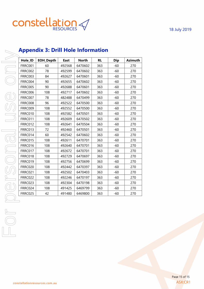
Drill hole
Information
A summary of all information material to the understanding
of the exploration results including a tabulation of the
following information for all Material drill holes:
o easting and northing of the drill hole collar
o elevation or RL (Reduced Level – elevation above sea
level in metres) of the drill hole collar
o dip and azimuth of the hole
o down hole length and interception depth
o hole length.
All assay and collar information are tabulated in Appendix 3 of
this report.
All significant intercepts are reported at 0.1g/t Au cut-off.
If the exclusion of this information is justified on the basis
that the information is not Material and this exclusion does
not detract from the understanding of the report, the
Competent Person should clearly explain why this is the
case.
NA
Data
aggregation
methods
In reporting Exploration Results, weighting averaging
techniques, maximum and/or minimum grade truncations
(eg cutting of high grades) and cut-off grades are usually
Material and should be stated.
Intersection lengths and grades for all holes are reported as
down-hole.
Where aggregate intercepts incorporate short lengths of
high grade results and longer lengths of low grade results,
the procedure used for such aggregation should be stated
and some typical examples of such aggregations should be
shown in detail.
NA
The assumptions used for any reporting of metal equivalent
values should be clearly stated.
No metal equivalent values are used.
Relationship
between
mineralisati
on widths
and
intercept
lengths
These relationships are particularly important in the
reporting of Exploration Results. If the geometry of the
mineralisation with respect to the drill hole angle is known,
its nature should be reported.
Drill hole intersections are reported down hole and true width is
unknown.
If it is not known and only the down hole lengths are
reported, there should be a clear statement to this effect (eg
‘down hole length, true width not known’).
NA
Diagrams Appropriate maps and sections (with scales) and tabulations
of intercepts should be included for any significant discovery
being reported These should include, but not be limited to a
plan view of drill hole collar locations and appropriate
sectional views.
Appropriate diagrams are included in the main body of this
report.
Balanced
reporting
Where comprehensive reporting of all Exploration Results is
not practicable, representative reporting of both low and
high grades and/or widths should be practiced to avoid
misleading reporting of Exploration Results.
Reporting of results is considered balanced.
Other
substantive
exploration
data
Other exploration data, if meaningful and material, should
be reported including (but not limited to): geological
observations; geophysical survey results; geochemical survey
results; bulk samples – size and method of treatment;
metallurgical test results; bulk density, groundwater,
geotechnical and rock characteristics; potential deleterious
or contaminating substances.
No additional meaningful and material exploration data has been
excluded from this report.
For
per
sona
l use
onl
y

18 July 2019
constellationresources.com.au
Page 14 of 15
Criteria JORC Code explanation Commentary
Further work The nature and scale of planned further work (e.g. tests for
lateral extensions or depth extensions or large-scale step-out
drilling).
No further drilling is currently planned over E63/1282, however
regional exploration related work planned for the Orpheus
Project includes ongoing review of the historical exploration
datasets and systematic follow-up geological mapping, rock
sampling and geophysical surveys e.g. ground based EM surveys,
over identified prospects and exploration targets. Drill testing (air
core and/or RC percussion and/or diamond drilling) will be
undertaken on priority targets identified.
Diagrams clearly highlighting the areas of possible
extensions, including the main geological interpretations
and future drilling areas, provided this information is not
commercially sensitive.
These diagrams are included in the main body of this report.
For
per
sona
l use
onl
y
18 July 2019
constellationresources.com.au
Page 15 of 15
Appendix 3: Drill Hole Information
Hole_ID EOH_Depth East North RL Dip Azimuth
FRRC001 60 492568 6470602 363 -60 270
FRRC002 78 492599 6470602 363 -60 270
FRRC003 84 492627 6470601 363 -60 270
FRRC004 90 492655 6470602 363 -60 270
FRRC005 90 492688 6470601 363 -60 270
FRRC006 108 492717 6470602 363 -60 270
FRRC007 78 482488 6470499 363 -60 270
FRRC008 96 492522 6470500 363 -60 270
FRRC009 108 492552 6470500 363 -60 270
FRRC010 108 492582 6470501 363 -60 270
FRRC011 108 492609 6470502 363 -60 270
FRRC012 108 492641 6470504 363 -60 270
FRRC013 72 492460 6470501 363 -60 270
FRRC014 60 492542 6470602 363 -60 270
FRRC015 108 492611 6470701 363 -60 270
FRRC016 108 492640 6470701 363 -60 270
FRRC017 108 492672 6470701 363 -60 270
FRRC018 108 492729 6470697 363 -60 270
FRRC019 108 492756 6470699 363 -60 270
FRRC020 108 492442 6470397 363 -60 270
FRRC021 108 492502 6470403 363 -60 270
FRRC022 108 492246 6470197 363 -60 270
FRRC023 108 492304 6470198 363 -60 270
FRRC024 108 491425 6469799 363 -60 270
FRRC025 42 491480 6469800 363 -60 270
For
per
sona
l use
onl
y

Appendix 5B Mining exploration entity and oil and gas exploration entity quarterly report
+ See chapter 19 for defined terms 1 September 2016 Page 1
+Rule 5.5
Appendix 5B
Mining exploration entity and oil and gas exploration entity quarterly report
Introduced 01/07/96 Origin Appendix 8 Amended 01/07/97, 01/07/98, 30/09/01, 01/06/10, 17/12/10, 01/05/13, 01/09/16
Name of entity
CONSTELLATION RESOURCES LIMITED
ABN Quarter ended (“current quarter”)
57 153 144 211 30 June 2019
Consolidated statement of cash flows Current quarter $A’000
Year to date (12 months)
$A’000
1. Cash flows from operating activities
- - 1.1 Receipts from customers
1.2 Payments for
(162) (511) (a) exploration & evaluation
(b) development - -
(c) production - -
(d) staff costs (110) (330)
(e) administration and corporate costs (58) (251)
1.3 Dividends received (see note 3) - -
1.4 Interest received 37 120
1.5 Interest and other costs of finance paid - -
1.6 Income taxes paid - -
1.7 Research and development refunds - -
1.8 Other (provide details if material) - -
1.9 Net cash from / (used in) operating activities
(293) (972)
2. Cash flows from investing activities
- (4)
2.1 Payments to acquire:
(a) property, plant and equipment
(b) tenements (see item 10) - -
(c) investments - -
(d) other non-current assets - -
For
per
sona
l use
onl
y

Appendix 5B Mining exploration entity and oil and gas exploration entity quarterly report
+ See chapter 19 for defined terms 1 September 2016 Page 2
Consolidated statement of cash flows Current quarter $A’000
Year to date (12 months)
$A’000
2.2 Proceeds from the disposal of:
- - (a) property, plant and equipment
(b) tenements (see item 10) - -
(c) investments - -
(d) other non-current assets - -
2.3 Cash flows from loans to other entities - -
2.4 Dividends received (see note 3) - -
2.5 Other (provide details if material) - -
2.6 Net cash from / (used in) investing activities
- (4)
3. Cash flows from financing activities
- 7,000 3.1 Proceeds from issues of shares
3.2 Proceeds from issue of convertible notes - -
3.3 Proceeds from exercise of share options - -
3.4 Transaction costs related to issues of shares, convertible notes or options
- (368)
3.5 Proceeds from borrowings - -
3.6 Repayment of borrowings - (100)
3.7 Transaction costs related to loans and borrowings
- -
3.8 Dividends paid - -
3.9 Other (provide details if material):
- Loan from parent (forgiven in April 2018)
-
-
-
3.10 Net cash from / (used in) financing activities
- 6,532
4. Net increase / (decrease) in cash and cash equivalents for the period
5,882 33 4.1 Cash and cash equivalents at beginning of
period
4.2 Net cash from / (used in) operating activities (item 1.9 above)
(293) (972)
4.3 Net cash from / (used in) investing activities (item 2.6 above)
- (4)
4.4 Net cash from / (used in) financing activities (item 3.10 above)
- 6,532
4.5 Effect of movement in exchange rates on cash held
- -
4.6 Cash and cash equivalents at end of period
5,589 5,589
For
per
sona
l use
onl
y

Appendix 5B Mining exploration entity and oil and gas exploration entity quarterly report
+ See chapter 19 for defined terms 1 September 2016 Page 3
5. Reconciliation of cash and cash equivalents
at the end of the quarter (as shown in the consolidated statement of cash flows) to the related items in the accounts
Current quarter $A’000
Previous quarter $A’000
5.1 Bank balances 16 2
5.2 Call deposits 5,573 5,880
5.3 Bank overdrafts - -
5.4 Other (provide details) - -
5.5 Cash and cash equivalents at end of quarter (should equal item 4.6 above)
5,589 5,882
6. Payments to directors of the entity and their associates Current quarter $A'000
6.1 Aggregate amount of payments to these parties included in item 1.2 155
6.2 Aggregate amount of cash flow from loans to these parties included in item 2.3
-
6.3 Include below any explanation necessary to understand the transactions included in items 6.1 and 6.2
Payments include director fees, superannuation and provision of a fully serviced office.
7. Payments to related entities of the entity and their associates
Current quarter $A'000
7.1 Aggregate amount of payments to these parties included in item 1.2 -
7.2 Aggregate amount of cash flow from loans to these parties included in item 2.3
-
7.3 Include below any explanation necessary to understand the transactions included in items 7.1 and 7.2
Not applicable
8. Financing facilities available Add notes as necessary for an understanding of the position
Total facility amount at quarter end
$A’000
Amount drawn at quarter end
$A’000
8.1 Loan facilities - -
8.2 Credit standby arrangements - -
8.3 Other (please specify) - -
8.4 Include below a description of each facility above, including the lender, interest rate and whether it is secured or unsecured. If any additional facilities have been entered into or are proposed to be entered into after quarter end, include details of those facilities as well.
For
per
sona
l use
onl
y
Appendix 5B Mining exploration entity and oil and gas exploration entity quarterly report
+ See chapter 19 for defined terms 1 September 2016 Page 4
9. Estimated cash outflows for next quarter $A’000
9.1 Exploration and evaluation (200)
9.2 Development -
9.3 Production -
9.4 Staff costs (77)
9.5 Administration and corporate costs (110)
9.6 Other (provide details if material) -
9.7 Total estimated cash outflows (387)
10. Changes in tenements (items 2.1(b) and 2.2(b) above)
Tenement reference and location
Nature of interest Interest at beginning of quarter
Interest at end of quarter
10.1 Interests in mining tenements and petroleum tenements lapsed, relinquished or reduced
- - - -
10.2 Interests in mining tenements and petroleum tenements acquired or increased
- - - -
Compliance statement
1 This statement has been prepared in accordance with accounting standards and policies which
comply with Listing Rule 19.11A.
2 This statement gives a true and fair view of the matters disclosed.
[lodged electronically without signature]
Sign here: ............................................................ Date: 18 July 2019
(Company secretary)
Print name: Lachlan Lynch
Notes
1. The quarterly report provides a basis for informing the market how the entity’s activities have been financed for the past quarter and the effect on its cash position. An entity that wishes to disclose additional information is encouraged to do so, in a note or notes included in or attached to this report.
2. If this quarterly report has been prepared in accordance with Australian Accounting Standards, the definitions in, and provisions of, AASB 6: Exploration for and Evaluation of Mineral Resources and AASB 107: Statement of Cash Flows apply to this report. If this quarterly report has been prepared in accordance with other accounting standards agreed by ASX pursuant to Listing Rule 19.11A, the corresponding equivalent standards apply to this report.
3. Dividends received may be classified either as cash flows from operating activities or cash flows from investing activities, depending on the accounting policy of the entity.
For
per
sona
l use
onl
y