Joshua Tree National Park Visual Resource Analysis Report · 31.05.2013 · JOSHUA TREE NATIONAL...
54
455 Capitol Mall Suite 350 Sacramento CA 95814 Tel •916.441.6575 Fax •916.441.6553 Southern California Office • 2550 N. Hollywood Way • Suite 203 • Burbank CA 91505 May 31, 2013 California Energy Commission Dockets Unit 1516 Ninth Street Sacramento, CA 95814-5512 Subject: JOSHUA TREE NATIONAL PARK VISUAL RESOURCES ANALYSIS REPORT PALEN SOLAR ELECTRIC GENERATING SYSTEM DOCKET NO. (09-AFC-7C) Enclosed for filing with the California Energy Commission is the electronic version of JOSHUA TREE NATIONAL PARK VISUAL RESOURCES ANALYSIS REPORT, for the Palen Solar Electric Generating System (09-AFC-7C). Sincerely, Marie Fleming DOCKETED California Energy Commission MAY 31 2013 TN # 71087 09-AFC-7C
-
Upload
hoangxuyen -
Category
Documents
-
view
219 -
download
0
Transcript of Joshua Tree National Park Visual Resource Analysis Report · 31.05.2013 · JOSHUA TREE NATIONAL...

455 Capitol Mall Suite 350
Sacramento CA 95814
Tel •916.441.6575
Fax •916.441.6553
Southern California Office • 2550 N. Hollywood Way • Suite 203 • Burbank CA 91505
May 31, 2013
California Energy Commission Dockets Unit 1516 Ninth Street Sacramento, CA 95814-5512 Subject: JOSHUA TREE NATIONAL PARK VISUAL RESOURCES ANALYSIS
REPORT PALEN SOLAR ELECTRIC GENERATING SYSTEM DOCKET NO. (09-AFC-7C)
Enclosed for filing with the California Energy Commission is the electronic version of JOSHUA TREE NATIONAL PARK VISUAL RESOURCES ANALYSIS REPORT, for the Palen Solar Electric Generating System (09-AFC-7C). Sincerely,
Marie Fleming
DOCKETEDCalifornia Energy Commission
MAY 31 2013
TN # 7108709-AFC-7C

Statement of Methodology of
Truescape Limited
On behalf of
BrightSource Energy
Palen
May 2013
Truescape Statement of Methodology Page 2 of 18
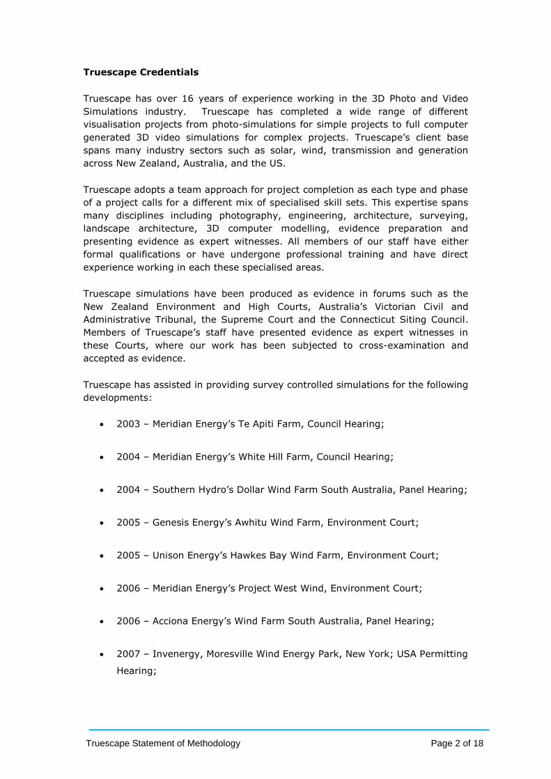
Truescape Credentials
Truescape has over 16 years of experience working in the 3D Photo and Video
Simulations industry. Truescape has completed a wide range of different
visualisation projects from photo-simulations for simple projects to full computer
generated 3D video simulations for complex projects. Truescape’s client base
spans many industry sectors such as solar, wind, transmission and generation
across New Zealand, Australia, and the US.
Truescape adopts a team approach for project completion as each type and phase
of a project calls for a different mix of specialised skill sets. This expertise spans
many disciplines including photography, engineering, architecture, surveying,
landscape architecture, 3D computer modelling, evidence preparation and
presenting evidence as expert witnesses. All members of our staff have either
formal qualifications or have undergone professional training and have direct
experience working in each these specialised areas.
Truescape simulations have been produced as evidence in forums such as the
New Zealand Environment and High Courts, Australia’s Victorian Civil and
Administrative Tribunal, the Supreme Court and the Connecticut Siting Council.
Members of Truescape’s staff have presented evidence as expert witnesses in
these Courts, where our work has been subjected to cross-examination and
accepted as evidence.
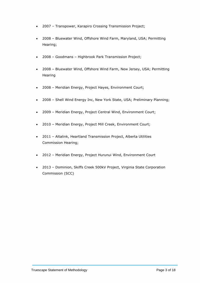
Truescape has assisted in providing survey controlled simulations for the following
developments:
2003 – Meridian Energy’s Te Apiti Farm, Council Hearing;
2004 – Meridian Energy’s White Hill Farm, Council Hearing;
2004 – Southern Hydro’s Dollar Wind Farm South Australia, Panel Hearing;
2005 – Genesis Energy’s Awhitu Wind Farm, Environment Court;
2005 – Unison Energy’s Hawkes Bay Wind Farm, Environment Court;
2006 – Meridian Energy’s Project West Wind, Environment Court;
2006 – Acciona Energy’s Wind Farm South Australia, Panel Hearing;
2007 – Invenergy, Moresville Wind Energy Park, New York; USA Permitting
Hearing;
Truescape Statement of Methodology Page 3 of 18
2007 – Transpower, Karapiro Crossing Transmission Project;
2008 – Bluewater Wind, Offshore Wind Farm, Maryland, USA; Permitting
Hearing;
2008 – Goodmans – Highbrook Park Transmission Project;
2008 – Bluewater Wind, Offshore Wind Farm, New Jersey, USA; Permitting
Hearing
2008 – Meridian Energy, Project Hayes, Environment Court;
2008 – Shell Wind Energy Inc, New York State, USA; Preliminary Planning;
2009 – Meridian Energy, Project Central Wind, Environment Court;
2010 – Meridian Energy, Project Mill Creek, Environment Court;
2011 – Altalink, Heartland Transmission Project, Alberta Utilities
Commission Hearing;
2012 – Meridian Energy, Project Hurunui Wind, Environment Court
2013 – Dominion, Skiffs Creek 500kV Project, Virginia State Corporation
Commission (SCC)
Truescape Statement of Methodology Page 4 of 18
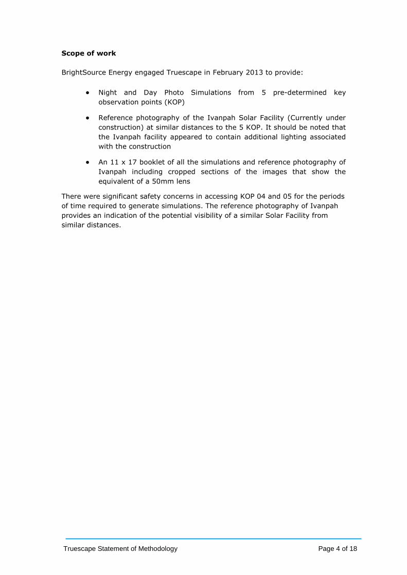
Scope of work
BrightSource Energy engaged Truescape in February 2013 to provide:
Night and Day Photo Simulations from 5 pre-determined key
observation points (KOP)
Reference photography of the Ivanpah Solar Facility (Currently under
construction) at similar distances to the 5 KOP. It should be noted that
the Ivanpah facility appeared to contain additional lighting associated
with the construction
An 11 x 17 booklet of all the simulations and reference photography of
Ivanpah including cropped sections of the images that show the
equivalent of a 50mm lens
There were significant safety concerns in accessing KOP 04 and 05 for the periods
of time required to generate simulations. The reference photography of Ivanpah
provides an indication of the potential visibility of a similar Solar Facility from
similar distances.

Truescape Statement of Methodology Page 5 of 18
Validation of the Truescape methodology
We have attached below some post construction analysis of the Project West
Wind wind farm that compared a simulation submitted at a Council hearing built
using the construction layout plan against the completed project. These
simulations demonstrate the accuracy of Truescape’s simulations. In particular, it
can be seen that the size and placement of the turbines in this simulation is
identical to the wind farm that was constructed. It should be noted that the
turbines in the simulation seem more obvious than the actual turbines in the
photograph due to the atmospheric conditions experienced on the day the
photograph was taken.
The simulation and photograph were produced 2 years and 7 days apart and both
are taken at the same time of day so as to produce the same lighting and shadow
conditions.
SIMULATION OF PROJECT WEST WIND PRE CONSTRUCTION (February 2008)
PHOTOGRAPH OF PROJECT WEST WIND POST CONSTRUCTION (February 2010)
Truescape Statement of Methodology Page 6 of 18
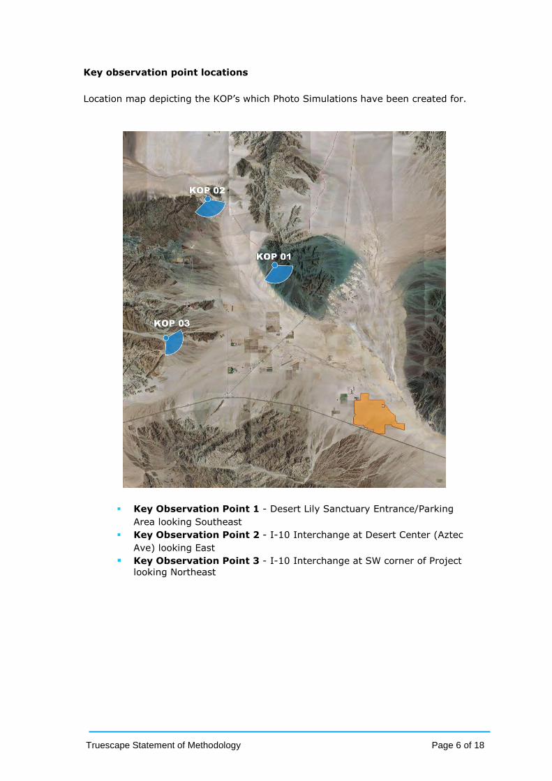
Key observation point locations
Location map depicting the KOP’s which Photo Simulations have been created for.
Key Observation Point 1 - Desert Lily Sanctuary Entrance/Parking
Area looking Southeast
Key Observation Point 2 - I-10 Interchange at Desert Center (Aztec
Ave) looking East
Key Observation Point 3 - I-10 Interchange at SW corner of Project
looking Northeast

Truescape Statement of Methodology Page 7 of 18
Key observation point locations
Location map depicting the KOP’s which reference photography of the under
construction Ivanpah Solar Facility has been captured.
Truescape Statement of Methodology Page 8 of 18
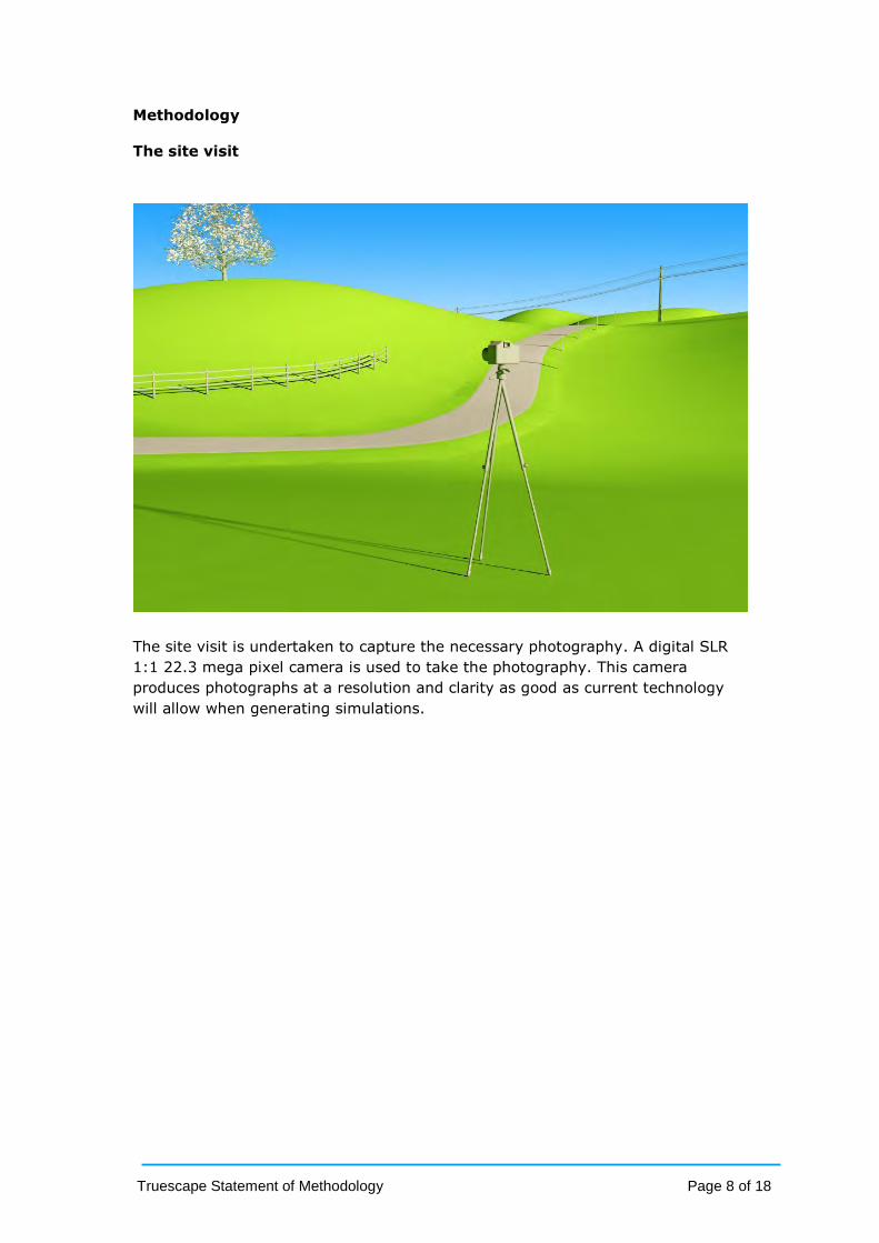
Methodology
The site visit
The site visit is undertaken to capture the necessary photography. A digital SLR
1:1 22.3 mega pixel camera is used to take the photography. This camera
produces photographs at a resolution and clarity as good as current technology
will allow when generating simulations.
Truescape Statement of Methodology Page 9 of 18
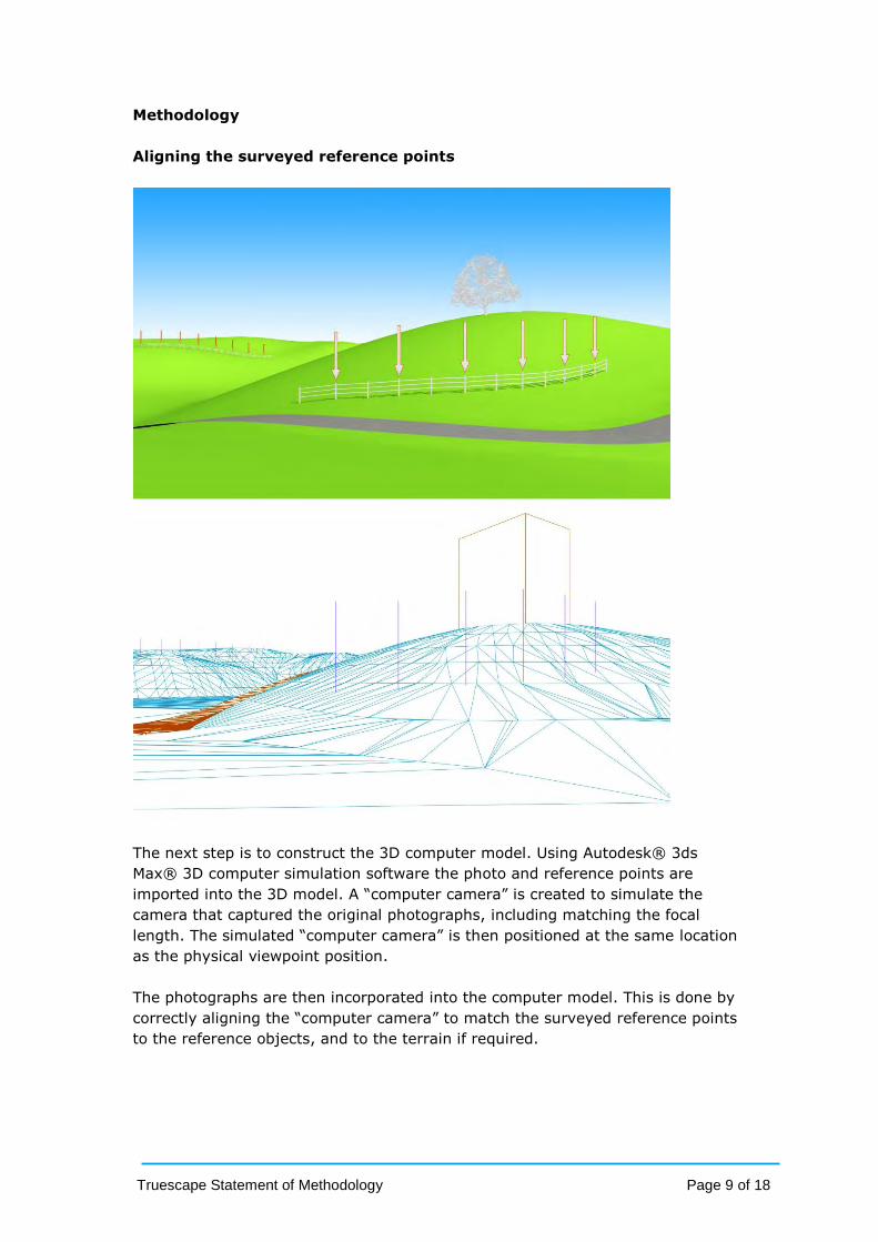
Methodology
Aligning the surveyed reference points
The next step is to construct the 3D computer model. Using Autodesk® 3ds
Max® 3D computer simulation software the photo and reference points are
imported into the 3D model. A “computer camera” is created to simulate the
camera that captured the original photographs, including matching the focal
length. The simulated “computer camera” is then positioned at the same location
as the physical viewpoint position.
The photographs are then incorporated into the computer model. This is done by
correctly aligning the “computer camera” to match the surveyed reference points
to the reference objects, and to the terrain if required.

Truescape Statement of Methodology Page 10 of 18
Methodology
Building the proposed project in 3D
The 3D terrain model of the site has been generated using the land contour data.
The proposed Palen Solar Project has been modelled in 3D and is now imported
and positioned accurately into the scene.
The simulation software allows the sun to be simulated at the precise time the
original photography was captured. This ensures the lighting of the structures as
well as the shadows they cast are an accurate depiction of how the Project would
appear in the photograph at the same time of day and reflecting the same
climatic conditions as those experienced at the time the photograph was taken.
Truescape Statement of Methodology Page 11 of 18
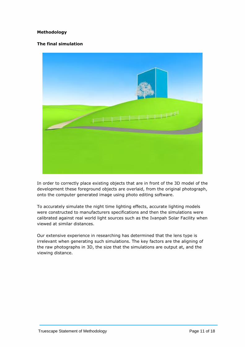
Methodology
The final simulation
In order to correctly place existing objects that are in front of the 3D model of the
development these foreground objects are overlaid, from the original photograph,
onto the computer generated image using photo editing software.
To accurately simulate the night time lighting effects, accurate lighting models
were constructed to manufacturers specifications and then the simulations were
calibrated against real world light sources such as the Ivanpah Solar Facility when
viewed at similar distances.
Our extensive experience in researching has determined that the lens type is
irrelevant when generating such simulations. The key factors are the aligning of
the raw photographs in 3D, the size that the simulations are output at, and the
viewing distance.

Truescape Statement of Methodology Page 12 of 18
Model input data
Site Plan supplied by BrightSource Energy.
5ft Contour Data for Site area provided by BrightSource Energy.

Truescape Statement of Methodology Page 13 of 18
Model input data
The 3D model as supplied by BrightSource Energy.
The 3D model as supplied by BrightSource Energy.

Truescape Statement of Methodology Page 14 of 18
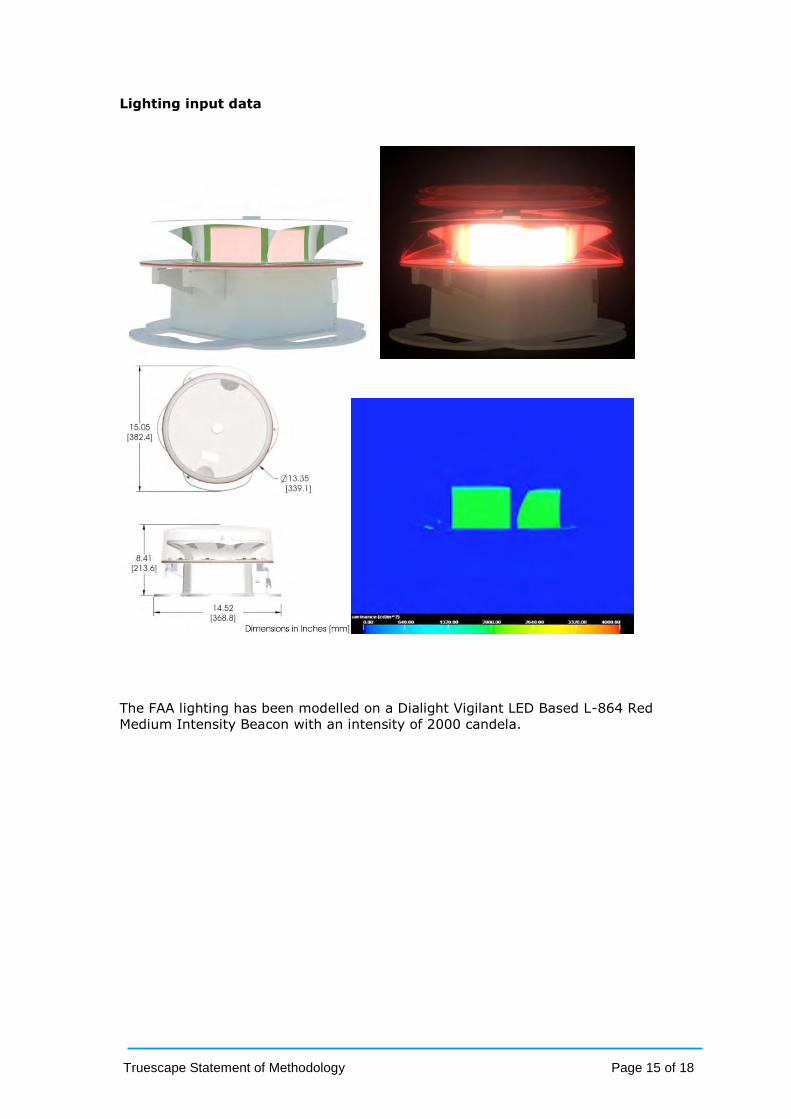
Lighting input data
Light plan supplied by BrightSource Energy.
FAA light spacing on tower supplied by BrightSource Energy.
Truescape Statement of Methodology Page 15 of 18
Lighting input data
The FAA lighting has been modelled on a Dialight Vigilant LED Based L-864 Red
Medium Intensity Beacon with an intensity of 2000 candela.

Truescape Statement of Methodology Page 16 of 18
Site Conditions
Simulations from KOP 4 and KOP 5 were not generated and in substitute of this
reference photography was captured of the Ivanpah solar facility (currently under
construction) at similar distances to these KOP’s. There were significant safety
concerns to access these distant points for the periods of time required to
generate simulations and in the case of KOP 4 the proposed project is not visible
directly. The reference photography of Ivanpah provides an indication of the
potential visibility.
The conditions on site were such that one could read of an A4 piece of paper and
see clear shadows on the ground due to the brightness of the moon. At the
distance of 35 miles the Ivanpah site was obstructed by the local geography. No
visible glare could be seen in the sky or on the distant haze.
It has to be noted that the Ivanpah site still contains construction lighting which
will make the site brighter than what it would be once the project is complete.
Our simulations compensate for this eventuality. We have been advised that
construction lighting sits at the site offset to the left of tower 02 (labelled “Lights
002” on the image below), therefore when in direct comparison to the
simulations, the simulations do not appear to be as bright around the base of the
towers and facilities.
Note: The image above has been captured with low exposure to help define
individual lights.
The right hand side images on the next page are representative of what the field
technician actually saw out on site.

Truescape Statement of Methodology Page 17 of 18
Reference Photography
The 4 images above are showing night time simulations of the Palen Project on
the left compared to the night time reference photos of the Ivanpah Solar Facility
on the right which currently is still under construction.
Truescape Statement of Methodology Page 18 of 18
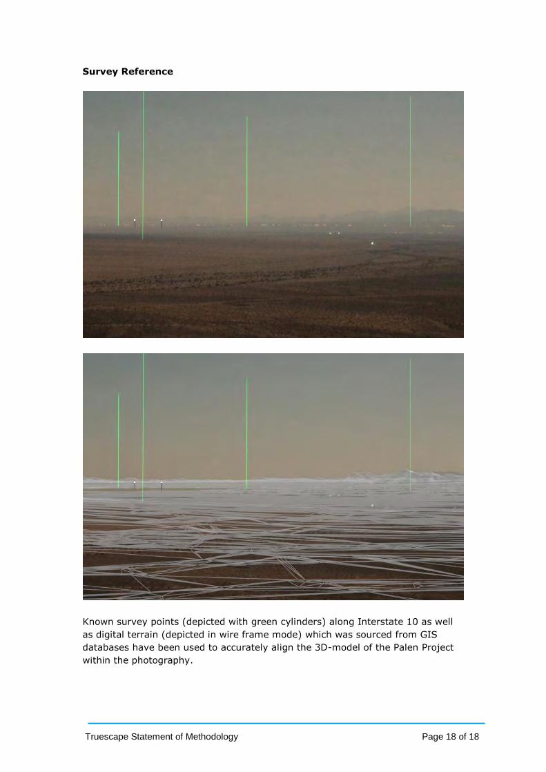
Survey Reference
Known survey points (depicted with green cylinders) along Interstate 10 as well
as digital terrain (depicted in wire frame mode) which was sourced from GIS
databases have been used to accurately align the 3D-model of the Palen Project
within the photography.

Brightsource Palen Solar
Photo Simulations
May 2013

Key Observation Point Locations
KOP 01 - Looking Southeast Off Desert Center Rice Road
KOP 02 - Looking Southeast Near Eagle Mountain
KOP 03 - Looking Southeast South of Eagle Mountain

page 3
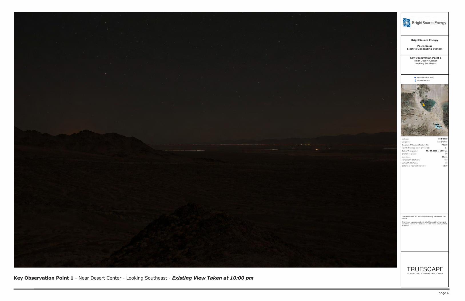
Key Observation Point 1 - Near Desert Center - Looking Southeast - Existing View Taken at 4:00 pm
Palen SolarElectric Generating System
BrightSource Energy
Key Observation Point
Proposed Facility
Latitude: 33.848735
Longitude: -115.341666
Elevation of Viewpoint Position (ft): 721.20
Height of Camera Above Ground (ft): 5.4
Date of Photography: May 17, 2013 at 4:00 pm
Orientation of View: SE
Lens type: 28mm
Horizontal Field of View: 65°
Vertical Field of View: 46°
Distance to nearest tower (mi): 12.38
Key Observation Point 1Near Desert CenterLooking Southeast
Camera location has been captured using a handheld GPS device.
This image was captured with a full frame 28mm lens and should be viewed at a distance of 10.9 inches when printed at 11x17.

page 4
Key Observation Point 1 - Near Desert Center - Looking Southeast - Proposed View Taken at 4:00 pm
Palen SolarElectric Generating System
BrightSource Energy
Key Observation Point
Proposed Facility
Latitude: 33.848735
Longitude: -115.341666
Elevation of Viewpoint Position (ft): 721.20
Height of Camera Above Ground (ft): 5.4
Date of Photography: May 17, 2013 at 4:00 pm
Orientation of View: SE
Lens type: 28mm
Horizontal Field of View: 65°
Vertical Field of View: 46°
Distance to nearest tower (mi): 12.38
Key Observation Point 1Near Desert CenterLooking Southeast
Camera location has been captured using a handheld GPS device.
This image was captured with a full frame 28mm lens and should be viewed at a distance of 10.9 inches when printed at 11x17.

page 5
Key Observation Point 1 - Near Desert Center - Looking Southeast - Proposed View Taken at 4:00 pm
Palen SolarElectric Generating System
BrightSource Energy
Key Observation Point
Proposed Facility
Latitude: 33.848735
Longitude: -115.341666
Elevation of Viewpoint Position (ft): 721.20
Height of Camera Above Ground (ft): 5.4
Date of Photography: May 17, 2013 at 4:00 pm
Orientation of View: SE
Lens type: 50mm Equivalent
Horizontal Field of View: 40°
Vertical Field of View: 27°
Distance to nearest tower (mi): 12.38
Key Observation Point 1Near Desert CenterLooking Southeast
Camera location has been captured using a handheld GPS device.
This image has been cropped and enlarged to display the equivalent of a full frame 50mm lens and should be viewed at a distance of 19.4 inches when printed at 11x17.
page 6
Key Observation Point 1 - Near Desert Center - Looking Southeast - Existing View Taken at 10:00 pm
Palen SolarElectric Generating System
BrightSource Energy
Key Observation Point
Proposed Facility
Latitude: 33.848735
Longitude: -115.341666
Elevation of Viewpoint Position (ft): 721.20
Height of Camera Above Ground (ft): 5.4
Date of Photography: May 17, 2013 at 10:00 pm
Orientation of View: SE
Lens type: 28mm
Horizontal Field of View: 65°
Vertical Field of View: 46°
Distance to nearest tower (mi): 12.38
Key Observation Point 1Near Desert CenterLooking Southeast
Camera location has been captured using a handheld GPS device.
This image was captured with a full frame 28mm lens and should be viewed at a distance of 10.9 inches when printed at 11x17.

page 7
Key Observation Point 1 - Near Desert Center - Looking Southeast - Proposed View Taken at 10:00 pm
Palen SolarElectric Generating System
BrightSource Energy
Key Observation Point
Proposed Facility
Latitude: 33.848735
Longitude: -115.341666
Elevation of Viewpoint Position (ft): 721.20
Height of Camera Above Ground (ft): 5.4
Date of Photography: May 17, 2013 at 10:00 pm
Orientation of View: SE
Lens type: 28mm
Horizontal Field of View: 65°
Vertical Field of View: 46°
Distance to nearest tower (mi): 12.38
Key Observation Point 1Near Desert CenterLooking Southeast
Camera location has been captured using a handheld GPS device.
This image was captured with a full frame 28mm lens and should be viewed at a distance of 10.9 inches when printed at 11x17.

page 8
Key Observation Point 1 - Near Desert Center - Looking Southeast - Proposed View Taken at 10:00 pm
Palen SolarElectric Generating System
BrightSource Energy
Key Observation Point
Proposed Facility
Latitude: 33.848735
Longitude: -115.341666
Elevation of Viewpoint Position (ft): 721.20
Height of Camera Above Ground (ft): 5.4
Date of Photography: May 17, 2013 at 10:00 pm
Orientation of View: SE
Lens type: 50mm Equivalent
Horizontal Field of View: 40°
Vertical Field of View: 27°
Distance to nearest tower (mi): 12.38
Key Observation Point 1Near Desert CenterLooking Southeast
Camera location has been captured using a handheld GPS device.
This image has been cropped and enlarged to display the equivalent of a full frame 50mm lens and should be viewed at a distance of 19.4 inches when printed at 11x17.

page 9
Key Observation Point 2 - Near Eagle Mountain - Looking Southeast - Existing View Taken at 4:00 pm
Palen SolarElectric Generating System
BrightSource Energy
Key Observation Point
Proposed Facility
Latitude: 33.921240
Longitude: -115.428565
Elevation of Viewpoint Position (ft): 524.03
Height of Camera Above Ground (ft): 5.4
Date of Photography: May 19, 2013 at 4:00 pm
Orientation of View: SE
Lens type: 28mm
Horizontal Field of View: 65°
Vertical Field of View: 46°
Distance to nearest tower (mi): 19.36
Key Observation Point 2Near Eagle MountainLooking Southeast
Camera location has been captured using a handheld GPS device.
This image was captured with a full frame 28mm lens and should be viewed at a distance of 10.9 inches when printed at 11x17.

page 10
Key Observation Point 2 - Near Eagle Mountain - Looking Southeast - Proposed View Taken at 4:00 pm
Palen SolarElectric Generating System
BrightSource Energy
Key Observation Point
Proposed Facility
Latitude: 33.921240
Longitude: -115.428565
Elevation of Viewpoint Position (ft): 524.03
Height of Camera Above Ground (ft): 5.4
Date of Photography: May 19, 2013 at 4:00 pm
Orientation of View: SE
Lens type: 28mm
Horizontal Field of View: 65°
Vertical Field of View: 46°
Distance to nearest tower (mi): 19.36
Key Observation Point 2Near Eagle MountainLooking Southeast
Camera location has been captured using a handheld GPS device.
This image was captured with a full frame 28mm lens and should be viewed at a distance of 10.9 inches when printed at 11x17.

page 11
Key Observation Point 2 - Near Eagle Mountain - Looking Southeast - Proposed View Taken at 4:00 pm
Palen SolarElectric Generating System
BrightSource Energy
Key Observation Point
Proposed Facility
Latitude: 33.921240
Longitude: -115.428565
Elevation of Viewpoint Position (ft): 524.03
Height of Camera Above Ground (ft): 5.4
Date of Photography: May 19, 2013 at 4:00 pm
Orientation of View: SE
Lens type: 50mm Equivalent
Horizontal Field of View: 40°
Vertical Field of View: 27°
Distance to nearest tower (mi): 19.36
Key Observation Point 2Near Eagle MountainLooking Southeast
Camera location has been captured using a handheld GPS device.
This image has been cropped and enlarged to display the equivalent of a full frame 50mm lens and should be viewed at a distance of 19.4 inches when printed at 11x17.

page 12
Key Observation Point 2 - Near Eagle Mountain - Looking Southeast - Existing View Taken at 10:00 pm
Palen SolarElectric Generating System
BrightSource Energy
Key Observation Point
Proposed Facility
Latitude: 33.921240
Longitude: -115.428565
Elevation of Viewpoint Position (ft): 524.03
Height of Camera Above Ground (ft): 5.4
Date of Photography: May 19, 2013 at 10:00 pm
Orientation of View: SE
Lens type: 28mm
Horizontal Field of View: 65°
Vertical Field of View: 46°
Distance to nearest tower (mi): 19.36
Key Observation Point 2Near Eagle MountainLooking Southeast
Camera location has been captured using a handheld GPS device.
This image was captured with a full frame 28mm lens and should be viewed at a distance of 10.9 inches when printed at 11x17.

page 13
Key Observation Point 2 - Near Eagle Mountain - Looking Southeast - Proposed View Taken at 10:00 pm
Palen SolarElectric Generating System
BrightSource Energy
Key Observation Point
Proposed Facility
Latitude: 33.921240
Longitude: -115.428565
Elevation of Viewpoint Position (ft): 524.03
Height of Camera Above Ground (ft): 5.4
Date of Photography: May 19, 2013 at 10:00 pm
Orientation of View: SE
Lens type: 28mm
Horizontal Field of View: 65°
Vertical Field of View: 46°
Distance to nearest tower (mi): 19.36
Key Observation Point 2Near Eagle MountainLooking Southeast
Camera location has been captured using a handheld GPS device.
This image was captured with a full frame 28mm lens and should be viewed at a distance of 10.9 inches when printed at 11x17.

page 14
Key Observation Point 2 - Near Eagle Mountain - Looking Southeast - Proposed View Taken at 10:00 pm
Palen SolarElectric Generating System
BrightSource Energy
Key Observation Point
Proposed Facility
Latitude: 33.921240
Longitude: -115.428565
Elevation of Viewpoint Position (ft): 524.03
Height of Camera Above Ground (ft): 5.4
Date of Photography: May 19, 2013 at 10:00 pm
Orientation of View: SE
Lens type: 50mm Equivalent
Horizontal Field of View: 40°
Vertical Field of View: 27°
Distance to nearest tower (mi): 19.36
Key Observation Point 2Near Eagle MountainLooking Southeast
Camera location has been captured using a handheld GPS device.
This image has been cropped and enlarged to display the equivalent of a full frame 50mm lens and should be viewed at a distance of 19.4 inches when printed at 11x17.

page 15
Key Observation Point 3 - South of Eagle Mountain - Looking Southeast - Existing View Taken at 4:00 pm
Palen SolarElectric Generating System
BrightSource Energy
Key Observation Point
Proposed Facility
Latitude: 33.771322
Longitude: -115.481469
Elevation of Viewpoint Position (ft): 524.03
Height of Camera Above Ground (ft): 5.4
Date of Photography: May 16, 2013 at 4:00 pm
Orientation of View: SE
Lens type: 28mm
Horizontal Field of View: 65°
Vertical Field of View: 46°
Distance to nearest tower (mi): 15.56
Key Observation Point 3South of Eagle Mountain
Looking Southeast
Camera location has been captured using a handheld GPS device.
This image was captured with a full frame 28mm lens and should be viewed at a distance of 10.9 inches when printed at 11x17.

page 16
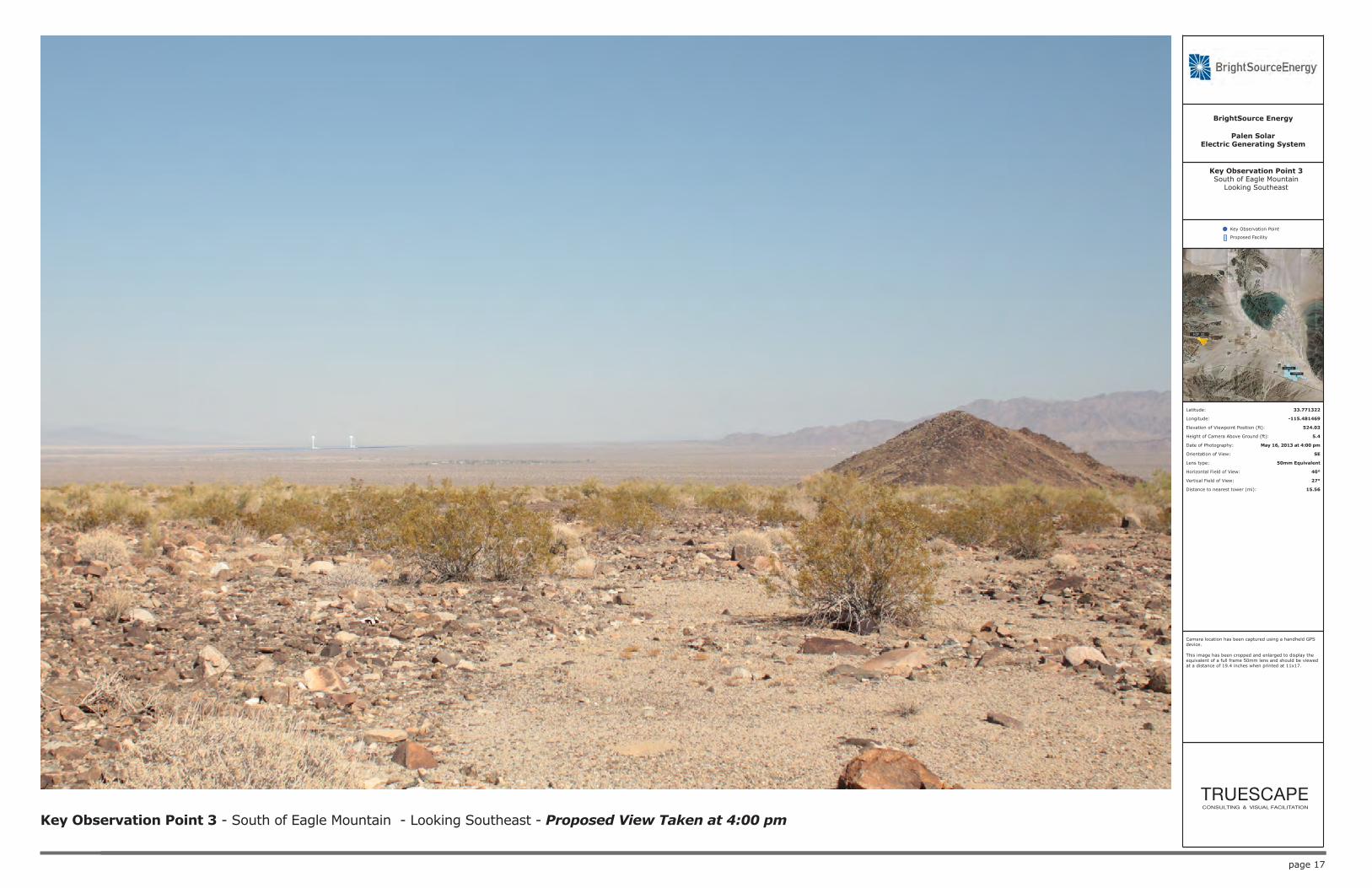
Key Observation Point 3 - South of Eagle Mountain - Looking Southeast - Proposed View Taken at 4:00 pm
Palen SolarElectric Generating System
BrightSource Energy
Key Observation Point
Proposed Facility
Latitude: 33.771322
Longitude: -115.481469
Elevation of Viewpoint Position (ft): 524.03
Height of Camera Above Ground (ft): 5.4
Date of Photography: May 16, 2013 at 4:00 pm
Orientation of View: SE
Lens type: 28mm
Horizontal Field of View: 65°
Vertical Field of View: 46°
Distance to nearest tower (mi): 15.56
Key Observation Point 3South of Eagle Mountain
Looking Southeast
Camera location has been captured using a handheld GPS device.
This image was captured with a full frame 28mm lens and should be viewed at a distance of 10.9 inches when printed at 11x17.
page 17
Key Observation Point 3 - South of Eagle Mountain - Looking Southeast - Proposed View Taken at 4:00 pm
Palen SolarElectric Generating System
BrightSource Energy
Key Observation Point
Proposed Facility
Latitude: 33.771322
Longitude: -115.481469
Elevation of Viewpoint Position (ft): 524.03
Height of Camera Above Ground (ft): 5.4
Date of Photography: May 16, 2013 at 4:00 pm
Orientation of View: SE
Lens type: 50mm Equivalent
Horizontal Field of View: 40°
Vertical Field of View: 27°
Distance to nearest tower (mi): 15.56
Key Observation Point 3South of Eagle Mountain
Looking Southeast
Camera location has been captured using a handheld GPS device.
This image has been cropped and enlarged to display the equivalent of a full frame 50mm lens and should be viewed at a distance of 19.4 inches when printed at 11x17.

page 18
Key Observation Point 3 - South of Eagle Mountain - Looking Southeast - Existing View Taken at 10:00 pm
Palen SolarElectric Generating System
BrightSource Energy
Key Observation Point
Proposed Facility
Latitude: 33.771322
Longitude: -115.481469
Elevation of Viewpoint Position (ft): 524.03
Height of Camera Above Ground (ft): 5.4
Date of Photography: May 16, 2013 at 10:00 pm
Orientation of View: SE
Lens type: 28mm
Horizontal Field of View: 65°
Vertical Field of View: 46°
Distance to nearest tower (mi): 15.56
Key Observation Point 3South of Eagle Mountain
Looking Southeast
Camera location has been captured using a handheld GPS device.
This image was captured with a full frame 28mm lens and should be viewed at a distance of 10.9 inches when printed at 11x17.

page 19
Key Observation Point 3 - South of Eagle Mountain - Looking Southeast - Proposed View Taken at 10:00 pm
Palen SolarElectric Generating System
BrightSource Energy
Key Observation Point
Proposed Facility
Latitude: 33.771322
Longitude: -115.481469
Elevation of Viewpoint Position (ft): 524.03
Height of Camera Above Ground (ft): 5.4
Date of Photography: May 16, 2013 at 10:00 pm
Orientation of View: SE
Lens type: 28mm
Horizontal Field of View: 65°
Vertical Field of View: 46°
Distance to nearest tower (mi): 15.56
Key Observation Point 3South of Eagle Mountain
Looking Southeast
Camera location has been captured using a handheld GPS device.
This image was captured with a full frame 28mm lens and should be viewed at a distance of 10.9 inches when printed at 11x17.
page 20
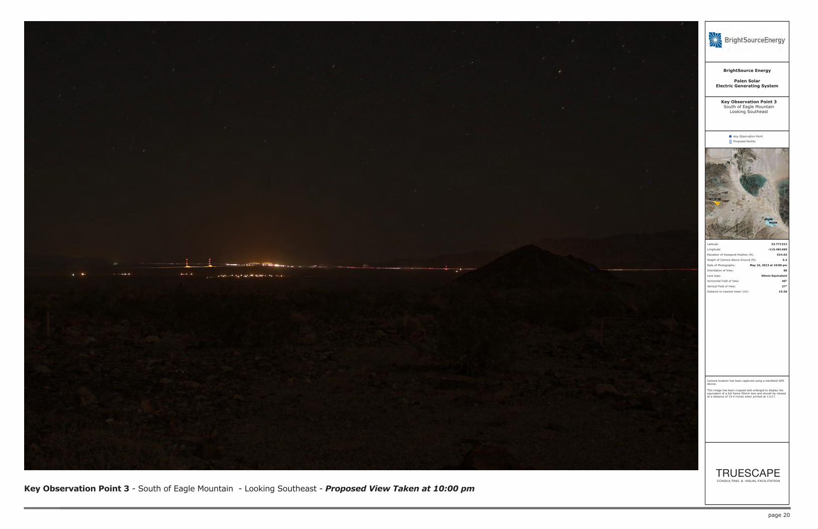
Key Observation Point 3 - South of Eagle Mountain - Looking Southeast - Proposed View Taken at 10:00 pm
Palen SolarElectric Generating System
BrightSource Energy
Key Observation Point
Proposed Facility
Latitude: 33.771322
Longitude: -115.481469
Elevation of Viewpoint Position (ft): 524.03
Height of Camera Above Ground (ft): 5.4
Date of Photography: May 16, 2013 at 10:00 pm
Orientation of View: SE
Lens type: 50mm Equivalent
Horizontal Field of View: 40°
Vertical Field of View: 27°
Distance to nearest tower (mi): 15.56
Key Observation Point 3South of Eagle Mountain
Looking Southeast
Camera location has been captured using a handheld GPS device.
This image has been cropped and enlarged to display the equivalent of a full frame 50mm lens and should be viewed at a distance of 19.4 inches when printed at 11x17.

Reference Point Locations
Reference Point 01 - Looking Southeast 29.3 Miles from plant - Pahrump Valley Rd
Reference Point 02 - Looking Southeast 34.9 Miles from plant - Pahrump Valley Rd

Reference Point Locations
Reference Point 03 - Looking Northwest 12 Miles from plant - Ivanpah Rd
Reference Point 04 - Looking Northwest 16 Miles from plant - Ivanpah Rd - Looking Northwest
Reference Point 05 - Looking Northwest 19.2 Miles from plant - Ivanpah Rd
page 23
Reference Point 1 - 29.3 Miles from plant - Pahrump Valley Rd - Looking Southeast - Reference Photography Taken at 12:06 am
Palen SolarElectric Generating System
BrightSource Energy
Key Observation Point
Proposed Facility
Latitude: 36.015152
Longitude: -115.67367
Elevation of Viewpoint Position (ft): 3815.6
Height of Camera Above Ground (ft): 5.4
Date of Photography: May 22, 2013 at 12:06 am
Orientation of View: SE
Lens type: 28mm
Horizontal Field of View: 65°
Vertical Field of View: 46°
Distance to nearest tower (mi): 29.3
Reference Point 1Pahrump Valley RdLooking Southeast
Reference Photography
Camera location has been captured using a handheld GPS device.
This image was captured with a full frame 28mm lens and should be viewed at a distance of 10.9 inches when printed at 11x17.

page 24
Reference Point 1 - 29.3 Miles from plant - Pahrump Valley Rd - Looking Southeast - Reference Photography Taken at 12:06 am
Palen SolarElectric Generating System
BrightSource Energy
Key Observation Point
Proposed Facility
Latitude: 36.015152
Longitude: -115.67367
Elevation of Viewpoint Position (ft): 3815.6
Height of Camera Above Ground (ft): 5.4
Date of Photography: May 22, 2013 at 12:06 am
Orientation of View: SE
Lens type: 50mm Equivalent
Horizontal Field of View: 40°
Vertical Field of View: 27°
Distance to nearest tower (mi): 29.3
Reference Point 1Pahrump Valley RdLooking Southeast
Reference Photography
Camera location has been captured using a handheld GPS device.
This image has been cropped and enlarged to display the equivalent of a full frame 50mm lens and should be viewed at a distance of 19.4 inches when printed at 11x17.
page 25
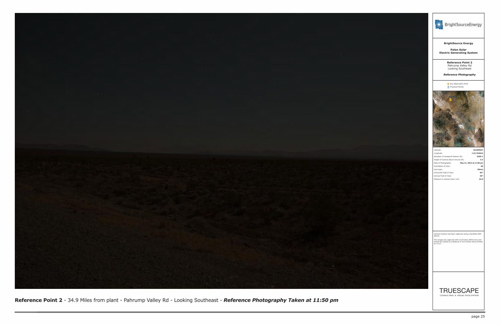
Reference Point 2 - 34.9 Miles from plant - Pahrump Valley Rd - Looking Southeast - Reference Photography Taken at 11:50 pm
Palen SolarElectric Generating System
BrightSource Energy
Key Observation Point
Proposed Facility
Latitude: 36.069957
Longitude: -115.763644
Elevation of Viewpoint Position (ft): 3395.7
Height of Camera Above Ground (ft): 5.4
Date of Photography: May 21, 2013 at 11:50 pm
Orientation of View: SE
Lens type: 28mm
Horizontal Field of View: 65°
Vertical Field of View: 46°
Distance to nearest tower (mi): 34.9
Reference Point 2Pahrump Valley RdLooking Southeast
Reference Photography
Camera location has been captured using a handheld GPS device.
This image was captured with a full frame 28mm lens and should be viewed at a distance of 10.9 inches when printed at 11x17.

page 26
Reference Point 2 - 34.9 Miles from plant - Pahrump Valley Rd - Looking Southeast - Reference Photography Taken at 11:50 pm
Palen SolarElectric Generating System
BrightSource Energy
Key Observation Point
Proposed Facility
Latitude: 36.069957
Longitude: -115.763644
Elevation of Viewpoint Position (ft): 3395.7
Height of Camera Above Ground (ft): 5.4
Date of Photography: May 21, 2013 at 11:50 pm
Orientation of View: SE
Lens type: 50mm Equivalent
Horizontal Field of View: 40°
Vertical Field of View: 27°
Distance to nearest tower (mi): 34.9
Reference Point 2Pahrump Valley RdLooking Southeast
Reference Photography
Camera location has been captured using a handheld GPS device.
This image has been cropped and enlarged to display the equivalent of a full frame 50mm lens and should be viewed at a distance of 19.4 inches when printed at 11x17.

page 27
Reference Point 3 - 12 Miles from plant - Ivanpah Rd - Looking Northwest - Reference Photography Taken at 2:10 am
Palen SolarElectric Generating System
BrightSource Energy
Key Observation Point
Proposed Facility
Latitude: 35.402765
Longitude: -115.369355
Elevation of Viewpoint Position (ft): 2759.2
Height of Camera Above Ground (ft): 5.4
Date of Photography: May 22, 2013 at 2:10 am
Orientation of View: NW
Lens type: 28m
Horizontal Field of View: 65°
Vertical Field of View: 46°
Distance to nearest tower (mi): 12
Reference Point 3Ivanpah Rd
Looking Northwest
Reference Photography
Camera location has been captured using a handheld GPS device.
This image was captured with a full frame 28mm lens and should be viewed at a distance of 10.9 inches when printed at 11x17.

page 28
Reference Point 3 - 12 Miles from plant - Ivanpah Rd - Looking Northwest - Reference Photography Taken at 2:10 am
Palen SolarElectric Generating System
BrightSource Energy
Key Observation Point
Proposed Facility
Latitude: 35.402765
Longitude: -115.369355
Elevation of Viewpoint Position (ft): 2759.2
Height of Camera Above Ground (ft): 5.4
Date of Photography: May 22, 2013 at 2:10 am
Orientation of View: NW
Lens type: 50mm Equivalent
Horizontal Field of View: 40°
Vertical Field of View: 27°
Distance to nearest tower (mi): 12
Reference Point 3Ivanpah Rd
Looking Northwest
Reference Photography
Camera location has been captured using a handheld GPS device.
This image has been cropped and enlarged to display the equivalent of a full frame 50mm lens and should be viewed at a distance of 19.4 inches when printed at 11x17.

page 29
Reference Point 4 - 16 Miles from plant - Ivanpah Rd - Looking Northwest - Reference Photography Taken at 2:22 am
Palen SolarElectric Generating System
BrightSource Energy
Key Observation Point
Proposed Facility
Latitude: 35.354878
Longitude: -115.327634
Elevation of Viewpoint Position (ft): 3241.5
Height of Camera Above Ground (ft): 5.4
Date of Photography: May 22, 2013 at 2:22 am
Orientation of View: NW
Lens type: 28mm
Horizontal Field of View: 65°
Vertical Field of View: 46°
Distance to nearest tower (mi): 16
Reference Point 4Ivanpah Rd
Looking Northwest
Reference Photography
Camera location has been captured using a handheld GPS device.
This image was captured with a full frame 28mm lens and should be viewed at a distance of 10.9 inches when printed at 11x17.

page 30
Reference Point 4 - 16 Miles from plant - Ivanpah Rd - Looking Northwest - Reference Photography Taken at 2:22 am
Palen SolarElectric Generating System
BrightSource Energy
Key Observation Point
Proposed Facility
Latitude: 35.354878
Longitude: -115.327634
Elevation of Viewpoint Position (ft): 3241.5
Height of Camera Above Ground (ft): 5.4
Date of Photography: May 22, 2013 at 2:22 am
Orientation of View: NW
Lens type: 50mm Equivalent
Horizontal Field of View: 40°
Vertical Field of View: 27°
Distance to nearest tower (mi): 16
Reference Point 4Ivanpah Rd
Looking Northwest
Reference Photography
Camera location has been captured using a handheld GPS device.
This image has been cropped and enlarged to display the equivalent of a full frame 50mm lens and should be viewed at a distance of 19.4 inches when printed at 11x17.

page 31
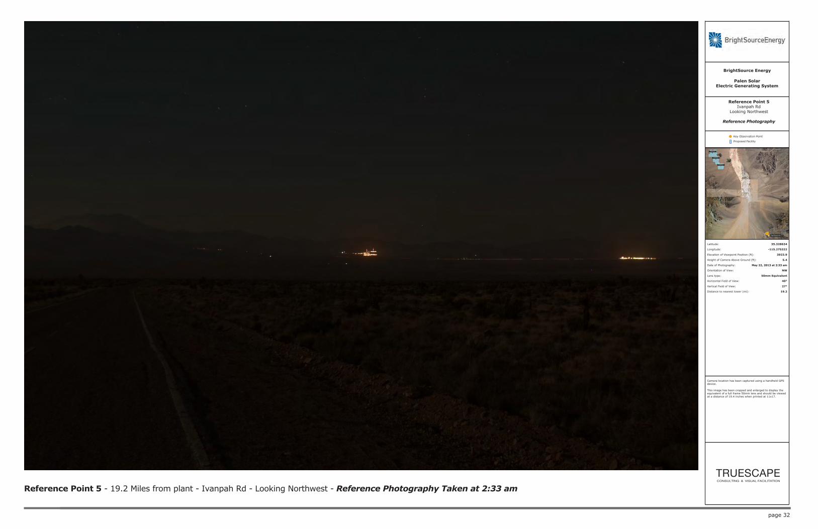
Reference Point 5 - 19.2 Miles from plant - Ivanpah Rd - Looking Northwest - Reference Photography Taken at 2:33 am
Palen SolarElectric Generating System
BrightSource Energy
Key Observation Point
Proposed Facility
Latitude: 35.328634
Longitude: -115.275322
Elevation of Viewpoint Position (ft): 3923.9
Height of Camera Above Ground (ft): 5.4
Date of Photography: May 22, 2013 at 2:33 am
Orientation of View: NW
Lens type: 28mm
Horizontal Field of View: 65°
Vertical Field of View: 46°
Distance to nearest tower (mi): 19.2
Reference Point 5Ivanpah Rd
Looking Northwest
Reference Photography
Camera location has been captured using a handheld GPS device.
This image was captured with a full frame 28mm lens and should be viewed at a distance of 10.9 inches when printed at 11x17.
page 32
Reference Point 5 - 19.2 Miles from plant - Ivanpah Rd - Looking Northwest - Reference Photography Taken at 2:33 am
Palen SolarElectric Generating System
BrightSource Energy
Key Observation Point
Proposed Facility
Latitude: 35.328634
Longitude: -115.275322
Elevation of Viewpoint Position (ft): 3923.9
Height of Camera Above Ground (ft): 5.4
Date of Photography: May 22, 2013 at 2:33 am
Orientation of View: NW
Lens type: 50mm Equivalent
Horizontal Field of View: 40°
Vertical Field of View: 27°
Distance to nearest tower (mi): 19.2
Reference Point 5Ivanpah Rd
Looking Northwest
Reference Photography
Camera location has been captured using a handheld GPS device.
This image has been cropped and enlarged to display the equivalent of a full frame 50mm lens and should be viewed at a distance of 19.4 inches when printed at 11x17.

1 *Indicates change
BEFORE THE ENERGY RESOURCES CONSERVATION AND DEVELOPMENT
COMMISSION OF THE STATE OF CALIFORNIA 1516 NINTH STREET, SACRAMENTO, CA 95814
1-800-822-6228 – WWW.ENERGY.CA.GOV
PALEN SOLAR ELECTRIC
GENERATING SYSTEM AMENDMENT
Docket No. 09-AFC-7C PROOF OF SERVICE (Revised 05/23/2013)
SERVICE LIST:
APPLICANT Palen Solar Holdings, LLC Clay Jensen 410 South Rampart Blvd., Suite 390 Las Vegas, NV 89145 [email protected]
Palen Solar Holdings, LLC Charlie Turlinski 1999 Harrison Street, Suite 2150 Oakland, CA 94612 [email protected]
Palen Solar Holdings, LLC *Amanda McCoy 1999 Harrison Street, Suite 2150 Oakland, CA 94612 [email protected]
APPLICANT’S CONSULTANT Centerline Andrea Grenier 1420 E. Roseville Parkway Suite 140-377 Roseville, CA 95661 [email protected]
APPLICANT’S COUNSEL Scott Galati, Esq. Marie Fleming Galati/Blek, LLP 455 Capitol Mall, Suite 350 Sacramento, CA 95814 [email protected] [email protected]
INTERESTED AGENCY California ISO [email protected]
County of Riverside Office of Riverside County Counsel Tiffany North 3960 Orange Street, Suite 500 Riverside, CA 92501 [email protected]
INTERVENORS Center for Biological Diversity Lisa T. Belenky, Senior Attorney 351 California St., Suite 600 San Francisco, CA 94104 [email protected]
Center for Biological Diversity Ileene Anderson Public Lands Desert Director PMB 447, 8033 Sunset Boulevard Los Angeles, CA 90046 [email protected]
Basin and Range Watch Kevin Emmerich Laura Cunningham P.O. Box 153 Baker, CA 92309 [email protected] [email protected]
Californians for Renewable Energy Alfredo Acosta Figueroa 424 North Carlton Avenue Blythe, CA 92225 [email protected]
California Unions for Reliable Energy Tanya A. Gulesserian Elizabeth Klebaner Adams Broadwell Joseph & Cardoza 601 Gateway Boulevard, Suite 1000 South San Francisco, CA 94080 [email protected] [email protected] Hildeberto Sanchez, Eddie Simmons, and Laborers’ International Union of North America, Local Union No. 1184 c/o Richard T. Drury Christina M. Caro Lozeau|Drury LLP 410 12th Street, Suite 250 Oakland, CA 94607 [email protected] [email protected] ENERGY COMMISSION STAFF Christine Stora Project Manager [email protected]
Jennifer Martin-Gallardo Staff Counsel [email protected]
ENERGY COMMISSION – PUBLIC ADVISER Blake Roberts Assistant Public Adviser [email protected]

2
COMMISSION DOCKET UNIT California Energy Commission Docket Unit Attn: Docket No. 09-AFC-7C 1516 Ninth Street, MS-4 Sacramento, CA 95814-5512 [email protected]
OTHER ENERGY COMMISSION PARTICIPANTS (LISTED FOR CONVENIENCE ONLY): After docketing, the Docket Unit will provide a copy to the persons listed below. Do not send copies of documents to these persons unless specifically directed to do so. KAREN DOUGLAS Commissioner and Presiding Member DAVID HOCHSCHILD Commissioner and Associate Member Kenneth Celli Hearing Adviser Galen Lemei Adviser to Presiding Member Jennifer Nelson Adviser to Presiding Member Gabe Taylor Adviser to Associate Member Eileen Allen Commissioners’ Technical Adviser for Facility Siting

3
DECLARATION OF SERVICE
I, Marie Fleming, declare that on May 31, 2013, I served and filed copies of the attached JOSHUA TREE NATIONAL PARK VISUAL RESOURCES ANALYSIS REPORT, dated May 2013. This document is accompanied by the most recent Proof of Service, which I copied from the web page for this project at: http://www.energy.ca.gov/sitingcases/palen/compliance/. The document has been sent to the other persons on the Service List above in the following manner:
(Check one) For service to all other parties and filing with the Docket Unit at the Energy Commission: I e-mailed the document to all e-mail addresses on the Service List above and personally delivered it or
deposited it in the U.S. mail with first class postage to those parties noted above as “hard copy required”; OR
X Instead of e-mailing the document, I personally delivered it or deposited it in the U.S. mail with first class
postage to all of the persons on the Service List for whom a mailing address is given.
I declare under penalty of perjury under the laws of the State of California that the foregoing is true and correct, and that I am over the age of 18 years. Dated: May 31, 2013 Marie Fleming