JOINT PUBLIC NOTICE - swl.usace.army.mil · US Army Corps of Engineers® ... The Union Pacific...
32
JOINT PUBLIC NOTICE CORPS OF ENGINEERS – STATE OF ARKANSAS US Army Corps of Engineers® Little Rock District - 1 - TO WHOM IT MAY CONCERN: Comments are invited on the work described below. Please see the Public Involvement section for details on submitting comments. Point of Contact. If additional information is desired, please contact the regulator, Johnny McLean, telephone number: (501) 340-1382, mailing address: Little Rock District Corps of Engineers, Regulatory Division, PO Box 867, Little Rock, Arkansas 72203-0867, email address: [email protected] Project Information. Pursuant to Section 404 of the Clean Water Act (33 U.S. Code 1344), notice is hereby given that Arkansas Department of Transportation (ArDOT) PO Box 2261 Little Rock, Arkansas 72203 has requested authorization for the placement of dredged and fill material in waters of the United States associated with replacing the Interstate 30 Bridge and approaches crossing the Arkansas River in Little Rock and North Little Rock as well as improving a portion of Interstate 30 (I-30) from Interstate 530 (I-530) and Interstate 440 (I-440) to Interstate 40 (I-40). The project would also improve a portion of I-40 from Highway 365 (MacArthur Drive) to US Highway 67/167 including associated interchanges. This project is commonly called the 30 Crossing Project. The proposed project is located in sections 2, 11 and 14, T. 1 N., R. 12 W., in sections 22, 25, 26, 27 and 35, T. 2 N., R. 12 W., and in section 30, T. 2 N., R. 11 W., Pulaski County, Arkansas. The Arkansas River is part of the 445-mile McClellan-Kerr Arkansas River Navigation System (MKARNS), which begins where the White River meets the Mississippi River near Dumas, Arkansas and extends to the Port of Catoosa near Tulsa, Oklahoma. The I-30 Bridge is located at MKARNS Navigation Mile 118.5. Construction of the new I-30 Bridge over the Arkansas River would require authorization from the U.S. Coast Guard (USCG) in accordance with Section 9 of the Rivers and Harbors Act (33 U.S. Code 403). The basic purpose of the ArDOT project is to increase the safety of vehicular traffic on I-30 and I-40 by correcting geometric deficiencies, modernizing infrastructure and maintaining a state of good repair, improving navigational safety on the MKARNS, correcting the I-30 Arkansas River Bridge deficiencies, and reducing traffic congestion by improving mobility on I-30 and I-40. The overall purpose of the project is to provide for increased travel speed and reduced travel time to downtown North Little Rock and Little Rock as traffic demand in this region increases in the future. The I-30 Arkansas River Bridge would be replaced with a new structure, correcting the functional and structural deficiencies and navigation safety issues. The project is not water dependent. Application Number: SWL 2014-00257-1 Date: July 5, 2018 Comments Due: July 30, 2018
Transcript of JOINT PUBLIC NOTICE - swl.usace.army.mil · US Army Corps of Engineers® ... The Union Pacific...
JOINT PUBLIC NOTICE CORPS OF ENGINEERS – STATE OF ARKANSAS
US Army Corps of Engineers® Little Rock District
- 1 -
TO WHOM IT MAY CONCERN: Comments are invited on the work described below.
Please see the Public Involvement section for details on submitting comments.
Point of Contact. If additional information is desired, please contact the regulator, Johnny
McLean, telephone number: (501) 340-1382, mailing address: Little Rock District Corps of
Engineers, Regulatory Division, PO Box 867, Little Rock, Arkansas 72203-0867, email address:
Project Information. Pursuant to Section 404 of the Clean Water Act (33 U.S. Code 1344),
notice is hereby given that
Arkansas Department of Transportation (ArDOT)
PO Box 2261
Little Rock, Arkansas 72203
has requested authorization for the placement of dredged and fill material in waters of the United
States associated with replacing the Interstate 30 Bridge and approaches crossing the Arkansas
River in Little Rock and North Little Rock as well as improving a portion of Interstate 30 (I-30)
from Interstate 530 (I-530) and Interstate 440 (I-440) to Interstate 40 (I-40). The project would
also improve a portion of I-40 from Highway 365 (MacArthur Drive) to US Highway 67/167
including associated interchanges. This project is commonly called the 30 Crossing Project. The
proposed project is located in sections 2, 11 and 14, T. 1 N., R. 12 W., in sections 22, 25, 26, 27
and 35, T. 2 N., R. 12 W., and in section 30, T. 2 N., R. 11 W., Pulaski County, Arkansas.
The Arkansas River is part of the 445-mile McClellan-Kerr Arkansas River Navigation
System (MKARNS), which begins where the White River meets the Mississippi River near
Dumas, Arkansas and extends to the Port of Catoosa near Tulsa, Oklahoma. The I-30 Bridge is
located at MKARNS Navigation Mile 118.5. Construction of the new I-30 Bridge over the
Arkansas River would require authorization from the U.S. Coast Guard (USCG) in accordance
with Section 9 of the Rivers and Harbors Act (33 U.S. Code 403).
The basic purpose of the ArDOT project is to increase the safety of vehicular traffic on I-30 and
I-40 by correcting geometric deficiencies, modernizing infrastructure and maintaining a state of
good repair, improving navigational safety on the MKARNS, correcting the I-30 Arkansas River
Bridge deficiencies, and reducing traffic congestion by improving mobility on I-30 and I-40.
The overall purpose of the project is to provide for increased travel speed and reduced travel time
to downtown North Little Rock and Little Rock as traffic demand in this region increases in the
future. The I-30 Arkansas River Bridge would be replaced with a new structure, correcting the
functional and structural deficiencies and navigation safety issues. The project is not water
dependent.
Application Number: SWL 2014-00257-1
Date: July 5, 2018
Comments Due: July 30, 2018
- 2 -
The total length of the project is approximately 7.3 miles. ArDOT attempted to minimize the
impacts of the project by constructing the majority of the project on existing alignment and
within their right-of-way. ArDOT has agreed to mitigate for the unavoidable impacts to
wetlands, streams and floodplains. This project is the largest and one of several projects in the
program known as the Connecting Arkansas Program (CAP). The CAP was approved by the
voters and is an accelerated state highway construction and improvement program. A major
component of the CAP is to implement a project (30 Crossing) to improve the I-30 corridor in
downtown Little Rock and North Little Rock.
The project is located in a highly-urbanized area that is experiencing slow but steady population
growth. According to Metroplan, the six-county metropolitan area around Little Rock has grown
by 5.5 % since the 2010 census, which is faster than 4.5 % growth for the U.S. overall. Saline
County remains the fastest-growing county in the four-county Central Arkansas region (Saline,
Faulkner, Lonoke, and Pulaski Counties) while Faulkner County is the second fastest-growing
county. Pulaski County is the slowest-growing county in Central Arkansas. According to
Imagine Central Arkansas, the 2040 Long Range Metropolitan Transportation Plan, Central
Arkansas is expected to grow from 671,400 people to almost one million people by 2040, with
most of this growth expected in the counties surrounding Pulaski County.
The I-30 corridor generally consists of three main lanes in each direction with parallel one-way
discontinuous frontage roads on each side of the interstate within the right-of-way along the
outer edge. In the northern portion of the project area, the I-40 corridor consists of three to four
main lanes in each direction with parallel one-way frontage roads on each side of the interstate
between the I-30/I-40 interchange and North Hills Boulevard. Within the project area, both I-30
and I-40 are classified as interstates, which are the highest classification of principal arterials.
Within the 7.3-mile corridor, there are four system (connections between interchanges)
interchanges: I-30 with I-530 and I-440, I-30 with I-630, I-30 with I-40 and I-40 with Highway
67/167. There are seven service interchanges providing access to the local streets and multiple
locations where I-30 crosses local streets without providing access. The Union Pacific Railroad
(UPRR) crosses the project area at two locations. In regard to structural deficiencies, I-30 and I-
40 were originally constructed with concrete pavement in the 1960’s. In the 1980’s, I-30 was
overlaid with asphalt and I-40 was overlaid with concrete; therefore, it has been over 30 years
since the pavement condition was improved. Portions of the project area will likely require some
level of pavement rehabilitation within the expected timeframe of this project to meet adequate
structural performance. Functional deficiencies that were identified as contributing to safety
issues along the corridor include (1) short acceleration ramps that do not allow vehicles to reach
highway speed before entering the interstate, (2) interchanges that are too close together, which
causes congestion as vehicles try to enter and leave the interstate at the same time within a short
distance, (3) sharp curves, which cause vehicles to slow and create congestion and (4) shoulders
that are too narrow to permit a disabled vehicle to safely pull off the roadway or allow
emergency vehicles to reach a crash site.
The I-30 Arkansas River Bridge was constructed in 1958 and was determined to be structurally
deficient by ArDOT in September 2017. ArDOT also determined that portions of the bridge are
fracture critical. The existing I-30 Arkansas River Bridge has a vertical clearance of 65.6 feet
and horizontal clearance of 174.5 feet for commercial barge traffic. When the bridge was
- 3 -
constructed, one pier was constructed in what would eventually become the commercial
navigation channel. This pier obstructs the channel and affects river navigation by dividing the
channel into two navigational spans (left descending and right descending), with substandard
(174.5 and 169.5 feet) horizontal navigational clearance in both spans. The five other bridge
structures in downtown Little Rock have at least a 300-foot-wide open (no obstructions) span
across the navigational channel. Also, the navigational opening for the I-30 Arkansas River
Bridge does not line up with the adjacent Clinton and Junction Bridges. The reduced horizontal
clearance due to the pier obstruction and poor alignment makes the I-30 Arkansas River Bridge
difficult for barges to navigate safely and restricts their operational speed. Barge collision data
provided by the USCG, indicates a total of five barge strikes have occurred at the site since 2001,
with the two most recent since August 2013. Barges striking the bridge could cause the
structurally deficient, fracture critical bridge to collapse. The USCG has requested that the
proposed new bridge provide a minimum vertical clearance of 63 feet and horizontal clearance of
320 feet.
The construction method for this project would be Design-Build. In Design-Build, the Design-
Builder is permitted to incorporate innovation into final design as long as the project purpose and
need, environmental commitments and contractual obligations are met. This allows for
innovation and cost efficiency. This would be the first time ArDOT has utilized this
methodology for a project.
As part of the environmental assessment (EA) process, several alternatives were initially
considered by the Federal Highway Administration and ArDOT. Action alternatives that did not
meet the stated purpose and need were eliminated. In addition to the No-Action Alternative, four
action alternatives were carried forward and evaluated in the EA. The four action alternatives
are Alternative 1A: 8-Lane General Purpose with single point urban interchange (SPUI) at
Highway 10, Alternative 1B: 8-Lane General Purpose with split diamond interchange (SDI) at
Highway 10, Alternative 2A: 6-Lane with collector/distributor (C/D) and SPUI at Highway 10
and Alternative 2B: 6-Lane with C/D and SDI at Highway 10. The No-Action Alternative
represents the case in which the proposed project is not constructed but could include future
projects identified through the long-range planning process for maintaining a state of good repair
as funding becomes available. The No-Action Alternative would not make any immediate
improvements to the existing roadway or any bridges throughout the I-30 corridor. The No-
Action Alternative does not meet the purpose and need for the project but it must be considered
for comparison purposes in accordance with the National Environmental Policy Act (NEPA).
The EA and the proposed preliminary design are currently available for public inspection by
visiting the 30 Crossing website (30Crossing.com) and the ArDOT website (ArDOT.gov). Print
copies are available for viewing at the ArDOT Central Office Headquarters (Alternative Delivery
Conference Room), located at 10324 Interstate 30 (Exit 130) in Little Rock; and at the Garver
Headquarters, located at 4701 Northshore Drive in North Little Rock. The EA can also be
viewed at the Central Arkansas Library, located at 100 South Rock Street in Little Rock; and at
the Laman Library, located at 2801 Orange Street in North Little Rock.
Alternative 2B (6-Lane with C/D and SDI at Highway 10) (see Sheet 3 of 23) has been identified
as the preferred alternative due to the following reasons related to the project goals: (1) It

- 4 -
improves local vehicle access to and from downtown Little Rock/North Little Rock by more
directly connecting the frontage road system to the C/D lanes crossing the Arkansas River; (2) it
optimizes opportunities for economic development by providing a continuous frontage road
system between I-630 and East 4th Street and connection to the River Market and Clinton Center
areas via President Clinton Avenue, 2nd Street and 3rd Street and allowing additional green
space for public use in downtown Little Rock; (3) it enhances east-west connectivity, including
bicycle and pedestrian connectivity, by removing the elevated ramps between President Clinton
Avenue and 3rd Street and by replacing the elevated Highway 10 Spur with an improved at-
grade 2nd Street; (4) it was identified by the local metropolitan planning organization (MPO) as
the locally preferred alternative and has received the most public and business support.
A total of approximately 9.7 acres of wetlands would be adversely affected by the preferred
alternative primarily through interchange construction and embankment widening.
Approximately 6.6 acres of wetlands would be permanently impacted by the project and
approximately 3.1 acres would be temporarily impacted. The 9.7 acres is comprised of 7.42
acres forested, 0.06 acres scrub-shrub, 1.20 acres of emergent wetlands, and 0.97 acres of
shallow open water. The impacted wetlands would generally be considered medium-to-high
value due to their ability to store flood water, filter sediments and nutrients, and provide habitat
for animals in the Arkansas River ecosystem. The 2002 Charleston Method was used to
calculate the mitigation credits needed for the unavoidable wetland impacts. ArDOT proposes to
utilize 101.16 credits from an approved wetland mitigation bank.
The project would permanently impact seven streams totaling approximately 1,371 linear feet.
Most of the streams at these locations have been previously altered through channelization,
excavation and straightening for highway construction and storm water conveyance. The
streams would be considered low-to-medium value. Three of the streams are perennial, one is
intermittent and three are ephemeral. The permanent impacts at Fairman Ditch and the Arkansas
River would exceed 300 linear feet and would require mitigation for the adverse impacts. The
2011 Little Rock District Stream Method was used to calculate the mitigation credits needed for
the unavoidable stream impacts. ArDOT proposes to utilize 1,778.8 credits from an approved
stream mitigation bank that services the area.
Temporary impacts to the Arkansas River would total approximately two acres. ArDOT
proposes to conventionally (heavy equipment) remove all railing, concrete bridge deck, non-
stability critical floorbeams and stringers. This material will not be allowed to enter the river.
The remaining steel floorbeams and girders will be temporarily dropped into the river. All steel
material dropped into the left descending navigation span will be removed within a maximum
24-hour MKARNS closure period to minimize impacts to commercial navigation. All other steel
material will be removed as soon as possible. The existing reinforced concrete piers adjacent to
the existing left descending channel will be demolished down to the mudline and removed within
a 24-hour MKARNS closure period. The remaining reinforced concrete piers in the river will be
demolished down to the mudline and removed from the water as soon as possible. It is likely
that explosives will be used for the demolition of the existing piers, steel floorbeams and
stringers. ArDOT proposes to remove all concrete debris greater than 6 inches in diameter from
the navigation channel and all concrete debris greater than 12 inches in diameter from outside the
navigation channel. The steel would be removed and recycled, and the concrete would be hauled
- 5 -
to an approved upland disposal site. Prior to any activities in the river, all river traffic would be
confined to using the left descending navigation span. Only the existing left descending
navigation span would be required to remain open during demolition of the existing bridge and
construction of the new bridge, except for short closures. The right descending navigation span
would be obstructed once construction of the new piers begins. Once the initial phases of the
new bridge construction are completed, all eastbound and westbound highway traffic would be
removed from the existing bridge to the new bridge. This would occur prior to any bridge
demolition activities. The existing pier protection cells would be removed only after all traffic
has been permanently removed from the existing bridge. Vehicular traffic flow across the bridge
would be maintained during peak (morning and evening) times; only temporary disruptions are
anticipated.
There are three Federally endangered or threatened species that have the potential to occur in the
project area. They are the Interior Least Tern (Sterna antillarum athalassos), the Piping Plover
(Charadrius melodus) and the Running Buffalo Clover (Trifolium stoloniferum). There are no
recorded locations for any of the three species within the project area and no habitat exists for the
Piping Plover or Running Buffalo Clover. The U.S. Fish and Wildlife Service concurred with
ArDOT’s finding that the proposed project may affect is not likely to adversely affect threatened
or endangered species.
The project was evaluated to determine if any encroachment into special flood hazard areas and
the 100-year floodplain, identified through the Federal Emergency Management Agency Flood
Insurance Rate Maps, would occur. ArDOT identified three areas where encroachment would
occur: the Arkansas River, Fourche Creek and the Dark Hollow Basin. Alternative 2B would
place 11.2 Acre-feet of fill in the Fourche Creek floodplain and 17.4 Acre-feet in the Dark
Hollow floodplain. Compensation storage areas totaling 11.9 Acre-feet and 26.1 Acre-feet
would be created within the I-30/I-440/I-530 and I-30/I-40 interchanges, respectively, to
compensate for the floodplain areas that have been filled. As part of the Design-Build process
for the Arkansas River Bridge, ArDOT would work with the city floodplain administrators to
determine if any compensation is needed for the fill(s) in the Arkansas River floodplain.
Alternative 2B would change travel patterns in downtown Little Rock due to the elimination of
the Highway 10 interchange. This alternative would eliminate approximately 47 on-street
parking spaces along East 2nd Street, Ferry Street and East 4th Street and, result in an increase of
15.7 acres of green space and provide an unobstructed open area under I-30 from the Arkansas
River to 3rd Street. The project would require the acquisition of approximately 13.0 acres of
right-of-way, affect 54 parcels of land and displace 5 businesses and 6 residences. All six
residential displacements are located along Cypress Street in North Little Rock. Acquisition and
relocation assistance would be provided to displaced persons in accordance with the Uniform
Relocation Assistance and Real Properties Acquisitions Policies Act of 1970. It is anticipated
that noise impacts would potentially occur along the entire corridor, including the areas of
minority and/or low income populations, and would affect all users of the facility including
environmental justice (EJ) and non-EJ populations. ArDOT identified 224 noise receptors that
would experience future (2041) noise levels that are considered to be a noise impact. Noise
abatement measures, such as construction of traffic noise barriers (walls), were evaluated for all
areas with noise impacts. Fifteen noise barriers were evaluated and three were determined to be

- 6 -
feasible and reasonable. The three barriers are: (1) West of I-30 from 21st Street to Union
Pacific Railroad in Little Rock, benefiting 84-86 residences, (2) West of I-30 between 17th Street
and 21st Street in Little Rock, benefiting 30-33 residences, and (3) East of I-30 between 13th
Street and 19th Street in North Little Rock, benefiting 87-139 residences. Construction activities
such as demolition, hauling, grading, paving and bridge construction would result in temporary
increases in noise along the project. Local noise ordinances may place restrictions on the
contractor, including limiting certain activities to specified hours, in order to reduce construction
noise impacts. The access changes in the area of the Curtis Sykes Drive and the Highway 10
interchange would occur in areas of high minority and/or low income populations. Access
would not be eliminated, merely shifted in location. The aesthetic changes would primarily be
temporary changes during construction and would occur throughout the project. The project
would include enhancements to aesthetics including improved lighting and aesthetic design
features that would occur throughout the project corridor, including minority and low-income
areas. The greatest changes in aesthetics would occur in the Highway 10 interchange area, where
the increase in green space would benefit minority and low-income populations. All five
residential displacements and one commercial displacement are located in a census block with a
minority population greater than 50% of the total population. Avoidance of these displacements
is not possible since they lie along the segment of Cypress Street that would be extended over the
UPRR from 9th Street to 13th Street. This would allow Cypress Street to become a one-way
southbound frontage road and would improve connectivity throughout the surrounding
neighborhood. These displacements would not be considered disproportionate to EJ populations,
because the EJ communities are located throughout the corridor and the total population of the
project area is predominantly minority.
There are a total of 136 listed or eligible historic properties within the area of potential effect
(APE) for this project. ArDOT, in consultation with the State Historic Preservation Officer and
Arkansas Historic Preservation Program, determined that the removal of the Locust Street
Overpass would be the only adverse effect to historic properties. Additionally, after surveying
all existing and new right-of-way, ArDOT determined that no cultural resources would be
adversely affected. There are three parks along the Arkansas River that would be affected by the
construction of the I-30 Arkansas River Bridge. The William J. Clinton Presidential Center and
Park and the Julius Breckling Riverfront Park are administered by the City of Little Rock. The
North Shore Riverwalk Park is administered by the City of North Little Rock. The proposed
I-30 Arkansas River Bridge would be wider than the existing bridge and would require ArDOT
to expand the air space agreement over the parks. Also, temporary construction easements
would be required. Land acquisition for easements would be 2.3 acres for the Clinton Center
Park, 0.1 acres for the Riverfront Park and 2.3 acres for the Riverwalk Park. FHWA determined
that the project will not harm the protected features, assets or activities that make the parks
important for recreation under Section 4(f).
There are 18 public and commercial utilities identified within the project corridor. The
following types of public and commercial utilities are believed to be present: gas/petroleum,
electric, water and sewer, and telecommunications/cable television. Many of these utilities are
attached to the I-30 Arkansas River Bridge. Additionally, the UPRR owns and operates major
rail utilities within the project corridor. Utilities present on the Arkansas River Bridge and
utilizing the fiber optic transfer buildings at the south and north ends of the bridge will be

- 7 -
impacted by the bridge replacement and the replacement of the buildings at both bridge ends.
The disposition of these utilities is not known at this time. Electric transmission lines at both the
I-30/I-530/I-440 interchange and I-30/I-40 interchange may be affected by the project and may
require relocation. Several large transverse sewer, water, and gas crossings of I-30 are present.
It is unknown at this time whether the preferred alternative would have an impact on these
utilities. For the replacement of the Arkansas River Bridge, the following options are being
considered for relocation of the impacted utilities: (1) the Design-Build contractor will place
new duct bank crossings on the new bridge and be responsible for connections to the existing
facilities at the bridge ends, (2) the utility owners would be responsible for working out
individual agreements with the Design-Build contractor and/or ArDOT to have their utilities
accommodated within an installed duct bank, (3) the utilities would not cross the river on the
I-30 Bridge but would bore under the river, or (4) the utilities would not cross the river on the
I-30 Bridge but would use the Junction or Clinton Bridges. Ramp profile adjustments are being
evaluated to avoid conflicts with the electric transmission lines. Vertical utility adjustments may
also be needed due to changes in the roadway grades.
The location and general plan for the proposed work are shown on the enclosed sheets 1 through
23.
Section 408 Review. Under 33 United States Code Section 408, the U.S. Army Corps of
Engineers (USACE) must review any proposals by private, public, tribal, or other federal
entities, to make alterations to, or temporarily or permanently occupy or use, any USACE
federally authorized Civil Works project. Proposed alterations must not be injurious to the
public interest or affect the usefulness of the USACE project. There are three USACE projects
that would be impacted by the 30 Crossing Project. They are the McClellan-Kerr Arkansas
River Navigation System, the North Little Rock Levee/Floodwall and the Fourche Bayou Basin
flood control project. A separate public notice will be sent out to solicit comments for these
impacts. If additional information regarding the Section 408 review is desired, please contact
Ms. Julia Smethurst, telephone number: (501) 324-5602, mailing address: Little Rock District
Corps of Engineers, PO Box 867, Little Rock, Arkansas 72203-0867, email address:
Water Quality Certification. By copy of this public notice, the applicant is requesting water
quality certification from the Arkansas Department of Environmental Quality (ADEQ) in
accordance with Section 401(a)(1) of the Clean Water Act. Upon completion of the comment
period and a public hearing, if held, a determination relative to water quality certification will be
made. Evidence of this water quality certification or waiver of the right to certify must be
submitted prior to the issuance of a Corps of Engineers permit.
Cultural Resources. ArDOT staff archeologists have reviewed topographic maps, the National
Register of Historic Places, and other data on reported sites in the area. The FHWA is the lead
agency for coordination with all associated Native American Nations and tribal governments.
The District Engineer invites responses to this public notice from Federal, State, and local
agencies; historical and archeological societies; Native American Nations and tribal governments
and other parties likely to have knowledge of or concerns with historic properties in the area.
- 8 -
Endangered Species. As stated above, The U.S. Fish and Wildlife Service concurred with
ArDOT’s finding that the proposed project may affect is not likely to adversely affect threatened
or endangered species. A copy of this notice is being furnished to the U.S. Fish and Wildlife
Service and appropriate state agencies and constitutes a request to those agencies to provide any
new or additional information on threatened or endangered species.
Floodplain. We are providing copies of this notice to appropriate floodplain officials in
accordance with 44 Code of Federal Regulations (CFR) Part 60 (Floodplain Management
Regulations Criteria for Land Management and Use) and Executive Order 11988 on Floodplain
Management.
Section 404(b)(1) Guidelines. The evaluation of activities to be authorized under this permit,
which involves the discharge of dredged or fill material will include application of guidelines
promulgated by the Administrator, Environmental Protection Agency, under authority of Section
404(b) of the Clean Water Act. These guidelines are contained in 40 Code of Federal CFR 230.
Public Involvement. Any interested party is invited to submit to the above-listed POC (Johnny
McLean) written comments or objections relative to the proposed work on or before July 30,
2018. Substantive comments, both favorable and unfavorable, will be accepted and made a part
of the record and will receive full consideration in determining whether this work would be in
the public interest. The decision whether to issue a permit will be based on an evaluation of the
probable impact including cumulative impacts of the proposed activity on the public interest.
That decision will reflect the national concern for both protection and utilization of important
resources. The benefit, which reasonably may be expected to accrue from the proposal, must be
balanced against its reasonably foreseeable detriments. All factors which may be relevant to the
proposal will be considered including the cumulative effects thereof; among those are
conservation, economics, aesthetics, general environmental concerns, wetlands, historic
properties, fish and wildlife values, flood hazards, floodplain values, land use, navigation,
shoreline erosion and accretion, recreation, water supply and conservation, water quality, energy
needs, safety, food and fiber production, mineral needs, considerations of property ownership
and, in general, the needs and welfare of the people.
The Corps of Engineers is soliciting comments from the public; Federal, state, and local agencies
and officials; Indian Tribes; and other interested parties in order to consider and evaluate the
impacts of this proposed activity. Any comments received will be considered by the Corps of
Engineers to determine whether to issue, modify, condition or deny a permit for this proposal.
To make this decision, comments are used to assess impacts on endangered species, historic
properties, water quality, general environmental effects, and the other public interest factors
listed above. Comments are used in the preparation of an Environmental Assessment and/or an
Environmental Impact Statement pursuant to the National Environmental Policy Act. Comments
are also used to determine the need for a public hearing and to determine the overall public
interest of the proposed activity.
Any person may request in writing within the comment period specified in this notice that a
public hearing be held to consider this application. Requests for public hearings shall state, with
particularity, the reasons for holding a public hearing. The District Engineer will determine if
- 9 -
the issues raised are substantial and whether a hearing is needed for making a decision.
NOTE: The mailing list for this Public Notice is arranged by state and county(s) where the
project is located, and includes any addressees who have asked to receive copies of all public
notices. Please discard notices that are not of interest to you. If you have no need for any of
these notices, please advise us so that your name can be removed from the mailing list.
Enclosures
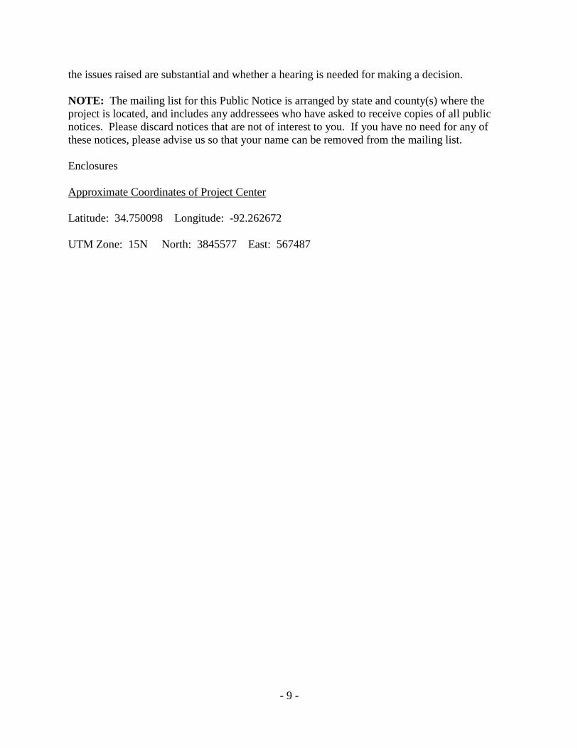
Approximate Coordinates of Project Center
Latitude: 34.750098 Longitude: -92.262672
UTM Zone: 15N North: 3845577 East: 567487
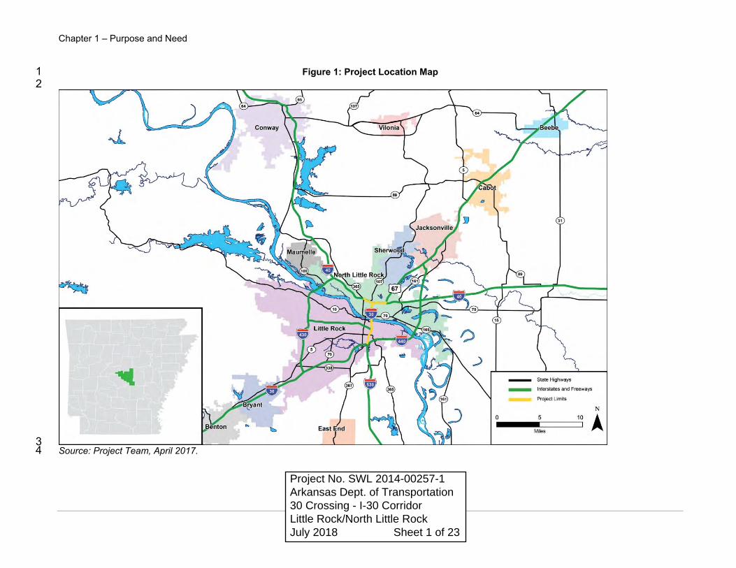
Chapter 1 – Purpose and Need
3
Figure 1: Project Location Map 1 2
3 Source: Project Team, April 2017. 4
Project No. SWL 2014-00257-1 Arkansas Dept. of Transportation 30 Crossing - I-30 Corridor Little Rock/North Little Rock July 2018 Sheet 1 of 23

Chapter 1 – Purpose and Need
5
Figure 2: Project Area 1
2 Source: Project Team, June 2017. 3
Sheet 2 of 23

Chapter 2 – Alternative Development
34
1 Figure 16: 6-Lane With C/D Action Alternative 2 2
3 Source: Project Team, May 2017. 4
Sheet 3 of 23

Chapter 2 – Alternative Development
42
1 Figure 22: 6-Lane with C/D with SDI Action Alternative (2B) 2
3
4 Source: Project Team, January 2018. 5 Sheet 4 of 23

2 mi
N
➤➤
N© 2018 Google
© 2018 Google
© 2018 Google
Wetlands 4, 5, 6 & 7 Streams 2 & 3
Wetland 10 Streams 5 &7
Wetland 12
Wetlands 14, 15, 16, 17, 18 & 19 Streams 14 & 15
Temp Work Road #1
Temp Work Road #2
Temp Work Roads #3 & #4
Sheet 5 of 23

1000 ft
N
➤➤
N© 2018 Google
© 2018 Google
© 2018 Google
Wetland 6 & Stream 3 0.06 ac forested permanent fill 233' culvert extension UTM 15S 569640.63 3848632.73
Wetland 5 1.12 ac forested permanent fill 0.54 ac forested temporary clear UTM 15S 569961.51 3848597.13
Wetland 7 0.67 ac permanent fill UTM 15S 569407.46 3848467.40
Stream 2 116' culvert extension UTM 15S 569996.32 3848597.13
Wetland 4 3.13 ac forested permanent fill 0.79 ac mowed ROW permanent fill 0.33 ac emergent permanent fill UTM 15S 15S 569781.31 38485115.18
Sheet 6 of 23
900 ft
N
➤➤
N© 2018 Google
© 2018 Google
© 2018 Google
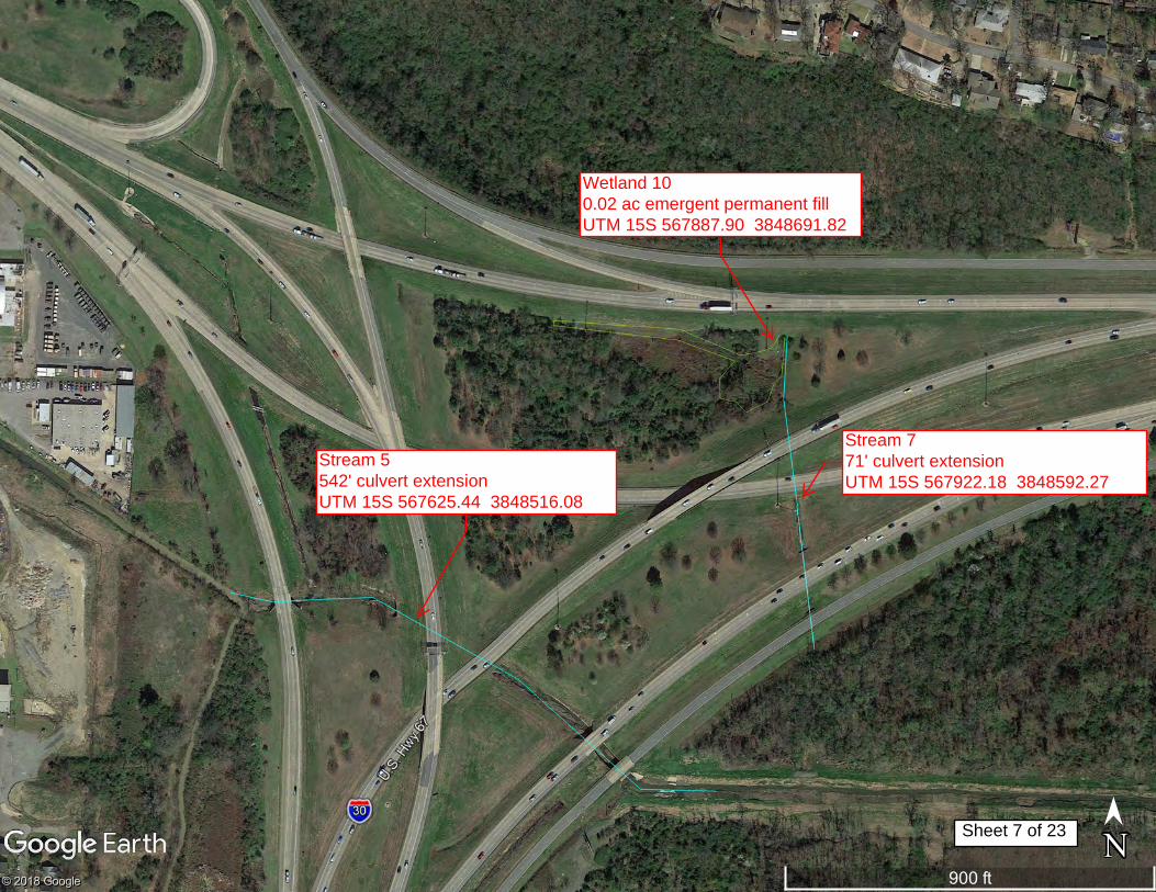
Wetland 10 0.02 ac emergent permanent fill UTM 15S 567887.90 3848691.82
Stream 7 71' culvert extension UTM 15S 567922.18 3848592.27
Stream 5 542' culvert extension UTM 15S 567625.44 3848516.08
Sheet 7 of 23

300 ft
N
➤➤
N© 2018 Google
© 2018 Google
© 2018 Google
Wetland 12 0.97 ac Riverine temporary fill Stream 10 (Arkansas River) 300' permanent riprap UTM 15S 567485.44 3845373.71
Sheet 8 of 23

700 ft
N
➤➤
N© 2018 Google
© 2018 Google
© 2018 Google
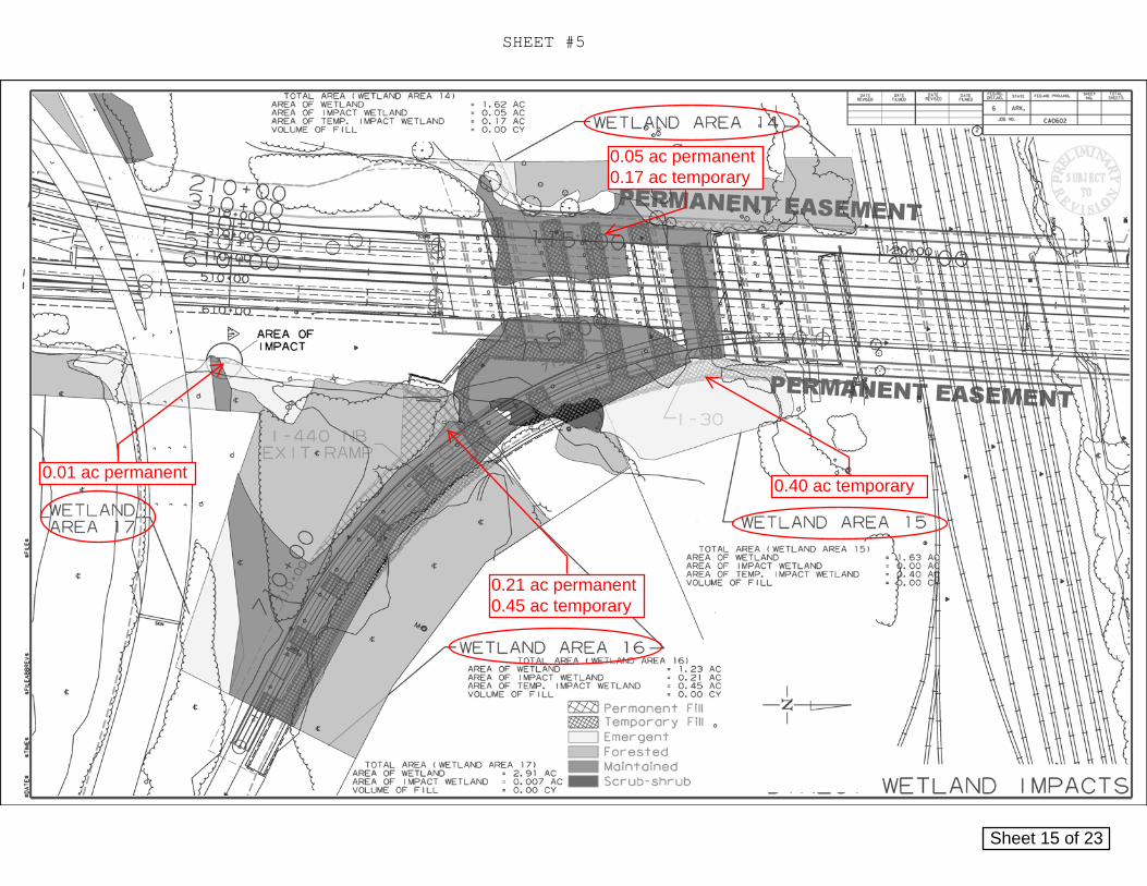
Wetland 14 0.05 ac emergent permanent fill 0.17 ac emergent temporary fill UTM 15S 566852.48 3841839.66
Wetland 15 0.40 ac emergent temporary fill UTM 15S 566933.29 3841816.45
Wetland 16 0.21 ac forested permanent fill 0.45 ac forested temporary fill UTM 15S 566944.05 3841720.55
Wetland 17 0.01 ac emergent permanent fill 0.41 ac forested temporary fill UTM 15S 566944.37 3841669.26
Sheet 9 of 23
800 ft
N
➤➤
N© 2018 Google
© 2018 Google
© 2018 Google
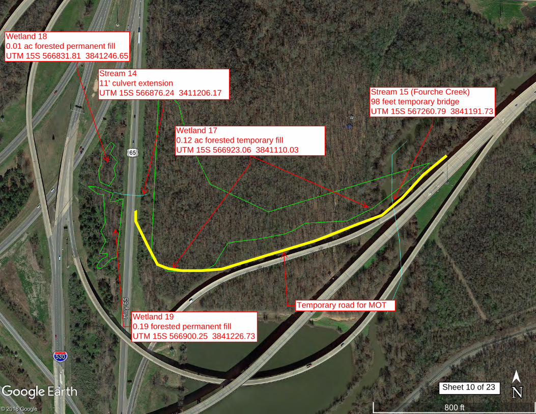
Stream 15 (Fourche Creek) 98 feet temporary bridge UTM 15S 567260.79 3841191.73
Wetland 17 0.12 ac forested temporary fill UTM 15S 566923.06 3841110.03
Stream 14 11' culvert extension UTM 15S 566876.24 3411206.17
Wetland 18 0.01 ac forested permanent fill UTM 15S 566831.81 3841246.65
Wetland 19 0.19 forested permanent fill UTM 15S 566900.25 3841226.73
Temporary road for MOT
Sheet 10 of 23
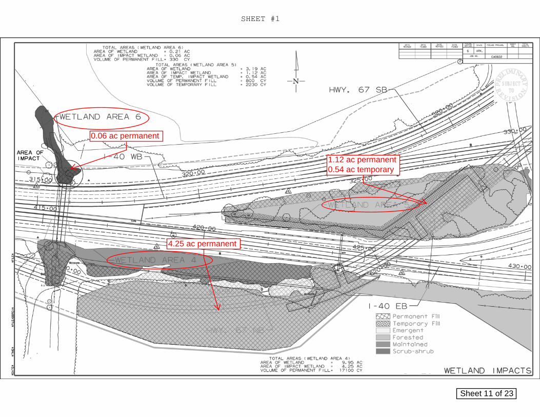
1.12 ac permanent 0.54 ac temporary
4.25 ac permanent
0.06 ac permanent
SHEET #1
Sheet 11 of 23

0.67 ac permanent
SHEET #2
Sheet 12 of 23
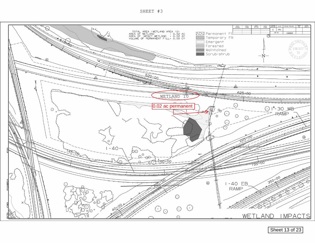
0.02 ac permanent
SHEET #3
WETLAND 10
Sheet 13 of 23

0.97 ac temporary
SHEET #4
Sheet 14 of 23
0.05 ac permanent 0.17 ac temporary
0.40 ac temporary
0.21 ac permanent 0.45 ac temporary
0.01 ac permanent
SHEET #5
Sheet 15 of 23
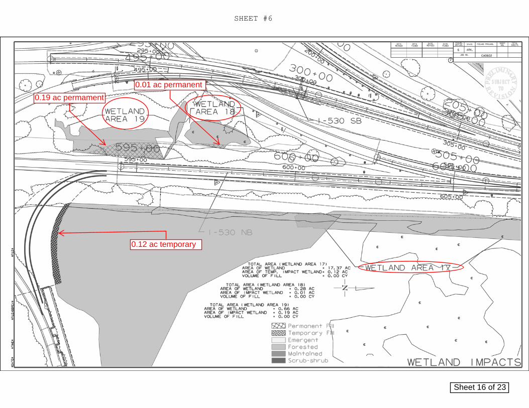
0.12 ac temporary
0.19 ac permament
0.01 ac permanent
SHEET #6
Sheet 16 of 23
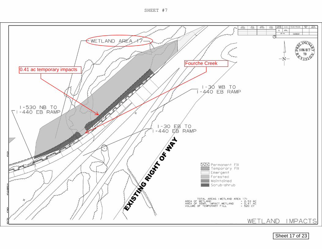
0.41 ac temporary impacts
SHEET #7
Fourche Creek
Sheet 17 of 23
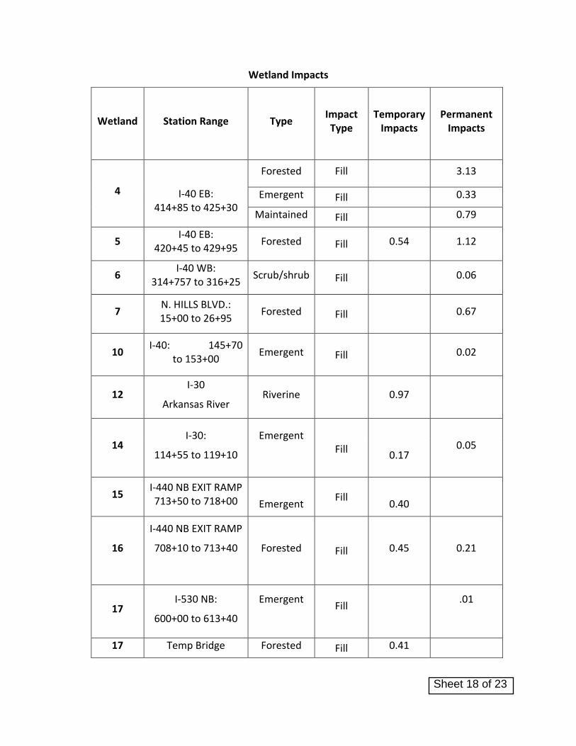
Wetland Impacts
Wetland Station Range Type Impact Type
Temporary Impacts
Permanent Impacts
4
I-40 EB: 414+85 to 425+30
Forested Fill 3.13
Emergent Fill 0.33
Maintained Fill 0.79
5 I-40 EB:
420+45 to 429+95 Forested Fill 0.54 1.12
6 I-40 WB:
314+757 to 316+25 Scrub/shrub Fill 0.06
7 N. HILLS BLVD.: 15+00 to 26+95
Forested Fill 0.67
10 I-40: 145+70
to 153+00 Emergent Fill 0.02
12 I-30
Arkansas River Riverine 0.97
14 I-30:
114+55 to 119+10
Emergent
Fill
0.05
0.17
15 I-440 NB EXIT RAMP 713+50 to 718+00
Emergent Fill
0.40
16
I-440 NB EXIT RAMP
708+10 to 713+40
Forested
Fill 0.45 0.21
17 I-530 NB:
600+00 to 613+40
Emergent
Fill
.01
17 Temp Bridge Forested Fill 0.41
Sheet 18 of 23
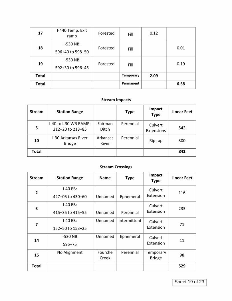
17 I-440 Temp. Exit
ramp Forested Fill 0.12
18 I-530 NB:
596+40 to 598+50 Forested Fill 0.01
19 I-530 NB:
592+30 to 596+45 Forested Fill 0.19
Total Temporary 2.09
Total Permanent 6.58
Stream Impacts
Stream Station Range
Type
Impact Type
Linear Feet
5 I-40 to I-30 WB RAMP:
212+20 to 213+85 Fairman
Ditch Perennial Culvert
Extensions 542
10 I-30 Arkansas River
Bridge Arkansas
River Perennial
Rip rap 300
Total 842
Stream Crossings
Stream Station Range Name Type Impact Type
Linear Feet
2 I-40 EB:
427+05 to 430+60
Unnamed
Ephemeral
Culvert Extension
116
3 I-40 EB:
415+35 to 415+55
Unnamed
Perennial
Culvert Extension
233
7 I-40 EB:
152+50 to 153+25
Unnamed Intermittent Culvert Extension
71
14 I-530 NB:
595+75
Unnamed Ephemeral Culvert Extension
11
15 No Alignment Fourche
Creek Perennial Temporary
Bridge 98
Total 529
Sheet 19 of 23

CA0602
30 Crossing
Pulaski County
7/5/2018
Factor Wetland 4 Wetland 4 Wetland 4 Wetland 5 Wetland 6 Wetland 7 Wetland 10 Wetland 12 Wetland 14 Wetland 14 Wetland 15 Wetland 16 Wetland 17 Wetland 17 Wetland 18 Wetland 19
Type A Type C Type B Type A Type B Type A Type B Type B Type B Type B Type B Type A Type A Type B Type A Type A
3.0 0.2 2.0 3.0 2.0 3.0 2.0 2.0 2.0 2.0 2.0 3.0 3.0 2.0 3.0 3.0
Secondary Tertiary Tertiary Tertiary Teriary Tertiary Tertiary Tertiary Secondary Secondary Secondary Secondary Secondary Secondary Secondary Secondary
1.5 0.5 0.5 0.5 0.5 0.5 0.5 0.5 1.5 1.5 1.5 1.5 1.5 1.5 1.5 1.5
Fully functional Impaired Impaired Slightly Impaired Slightly Impaired Slightly Impaired Very Impaired Slightly Impaired Slightly Impaired Fully functional Fully functional Fully functional Fully functional Fully functional Slightly Impaired Slightly Impaired
3.0 1.0 1.0 2.0 2.0 2.0 0.1 0.1 2.0 3.0 3.0 3.0 3.0 3.0 2.0 2.0
Over 10 Over 10 Over 10 Over 10 Over 10 Over 10 Over 10 1 to 3 Over 10 1 to 3 1 to 3 Over 10 Over 10 Over 10 Over 10 Over 10
2.0 2.0 2.0 2.0 2.0 2.0 2.0 0.5 1.0 0.5 0.5 2.0 2.0 1.0 2.0 2.0
Fill Fill Fill Clear Fill Fill Fill fill Fill Fill Fill Clear Fill Fill Fill Fill
3.0 3.0 3.0 1.0 3.0 3.0 3.0 3.0 3.0 3.0 3.0 1.0 3.0 3.0 3.0 3.0
Sum of r
Factors (Rx)12.9 7.1 8.9 8.9 9.9 10.9 8.0 6.5 9.9 10.4 10.4 10.9 12.9 10.9 11.9 11.9
Impacted Area
(AAx)3.13 0.79 0.33 1.66 0.06 0.67 0.02 0.97 0.05 0.17 0.40 0.66 0.53 0.01 0.01 0.19
RxAA= 40.37 5.63 2.95 14.82 0.60 7.32 0.16 6.30 0.50 1.77 4.17 7.21 6.85 0.11 0.12 2.26
101.16
0.43 0.43
Emergent
0.43
Emergent
0.43
Emergent
0.43
Emergent
0.43
Riverine
0.43 0.43
Required Mitigation Credits Worksheet
Forested Herbaceous Emergent
0.43 0.43 0.430.43 0.43 0.43
Forested Forested Forested
0.43
Forested
Total Required Credits = Σ(RxAA) =
Cumulative
Impact
Forested Forested Scrub/ShrubWetland Type
Lost Type
Priority
Category
Existing
Condition
Duration
Dominant
Impact
Maintained
0.43
Sheet 20 of 23

Sheet 21 of 23

EXHIBIT 1. SUMMARY OF FILL MATERIALS AND QUANTITIES
Fourche Creek
Excavation for foundations 84
Fill for foundation 84
Temporary Work Road 1 434
SUB TOTAL 518
Work Road 1a 3725
Temporary Ramp Fill 12800
Permanent Fill 7100
Temporary Work Road 1b 7200
SUB TOTAL 30,825
Arkansas River Bridge
Removal of old Bridge
Foundations 2647
Pier Protection 11556
SUB TOTAL 14,203
New Construction
Excavation for foundations 10091
Removal of exsting pier/structure 14209
Fill for foundation 13785
Fill for riprap south side 2233
Temporary Work Road 2 10448
SUB TOTAL 26466
North Hills
New construction
Fill for embankment 1034
I-40WB
New construction
Fill for embankment 330
Ramp I40EB - Hwy67NB
New construction
Excavation for foundations
Fill for foundation 331
Fill for embankment 16734
Fill for concrete riprap 11
Temporary Work Road 3 2228
Temporary Work Road 4 1455
SUB TOTAL 20759
TOTAL - Cubic Yards Fill 94136
Location/Type
Estimated Fill
Volumes Below the
OHWM
Estimated
Excavation Below
the OHWM
Sheet 22 of 23

TOTAL - Cubic Yards Excavation 24384
Sheet 23 of 23