JOINT CENTER FOR SATELLITE DATA … and Workshop Summary 12 PEOPLE Commander Nick Vincent Named...
15
NEWS IN THIS QUARTER SCIENCE UPDATE GSI Goes Operational at the Air Force Weather Agency The Air Force Weather Agency (AFWA) has been utilizing the Weather Research & Forecast- ing (WRF) model as its numerical weather prediction model of choice since 2007. From the first operational WRF model run, AFWA has employed the three-dimensional variational analysis (3DVAR) data assimilation (DA) system developed at the National Center for At- mospheric Research (NCAR) to produce the initial conditions for the forecast model. In 2012, AFWA began preparing its infrastructure to transition its DA system to the Gridpoint Statistical Interpolation (GSI) DA system developed at the National Centers for Environ- mental Prediction (NCEP) and used operationally in their suite of models. AFWA’s Initial Operational Capability (IOC) was met when the first operational domain began using GSI in July 2013. By the end of 2013, all of AFWA’s regional modeling efforts had transitioned to GSI. At the time of IOC, AFWA began assimilating data from AMSU, HIRS, MHS, IASI, C-NOFS, and COSMIC, in addition to conventional observations. AFWA was able to directly assimi- late radiance data for the first time. These data are critically important to meet AFWA’s re- quirement to support its global mission. The transition to GSI immediately allowed AFWA to increase the number of observations assimilated by as many as 5-10 times, depending on the domain. Additionally, in a March 2014 GSI implementation, AFWA added the capability to assimilate CrIS and ATMS from Suomi-NPP, AMSU, MHS, and ASCAT from MetOp-B, as well as TerraSAR-X. As it currently stands, AFWA assimilates approximately 5 million radiance observations per day. Over the next several months AFWA will continue to add the capability to assimilate additional data. IN THIS ISSUE 1 NEWS IN THIS QUARTER GSI Goes Operational at the Air Force Weather Agency Proactive Quality Control in Data Assimilation 7 OTHER NEWS S4 – JIBB Upgrade Status Call for Papers 10 MEETING REPORTS 12 th Annual JCDSA Technical Review and Workshop Summary 12 PEOPLE Commander Nick Vincent Named Chairman of the Management Oversight Board for JCSDA Welcome Aboard, Eric Maddy Welcome Aboard, Yingtao Ma 13 CAREER OPPORTUNITIES NOAA 14 NOTE FROM THE DIRECTOR 15 SCIENCE CALENDAR (continued on page 2) NO. 47, JUNE 2014 JCSDA Quarterly JOINT CENTER FOR SATELLITE DATA ASSIMILATION NOAA | NASA | US NAVY | US AIR FORCE
Transcript of JOINT CENTER FOR SATELLITE DATA … and Workshop Summary 12 PEOPLE Commander Nick Vincent Named...

NEWS IN THIS QUARTER SCIENCE UPDATE
GSI Goes Operational at the Air Force Weather AgencyThe Air Force Weather Agency (AFWA) has been utilizing the Weather Research & Forecast-ing (WRF) model as its numerical weather prediction model of choice since 2007. From the first operational WRF model run, AFWA has employed the three-dimensional variational analysis (3DVAR) data assimilation (DA) system developed at the National Center for At-mospheric Research (NCAR) to produce the initial conditions for the forecast model. In 2012, AFWA began preparing its infrastructure to transition its DA system to the Gridpoint Statistical Interpolation (GSI) DA system developed at the National Centers for Environ-mental Prediction (NCEP) and used operationally in their suite of models. AFWA’s Initial Operational Capability (IOC) was met when the first operational domain began using GSI in July 2013. By the end of 2013, all of AFWA’s regional modeling efforts had transitioned to GSI.
At the time of IOC, AFWA began assimilating data from AMSU, HIRS, MHS, IASI, C-NOFS, and COSMIC, in addition to conventional observations. AFWA was able to directly assimi-late radiance data for the first time. These data are critically important to meet AFWA’s re-quirement to support its global mission. The transition to GSI immediately allowed AFWA to increase the number of observations assimilated by as many as 5-10 times, depending on the domain. Additionally, in a March 2014 GSI implementation, AFWA added the capability to assimilate CrIS and ATMS from Suomi-NPP, AMSU, MHS, and ASCAT from MetOp-B, as well as TerraSAR-X. As it currently stands, AFWA assimilates approximately 5 million radiance observations per day. Over the next several months AFWA will continue to add the capability to assimilate additional data.
IN THIS ISSUE 1 NEWS IN THIS QUARTER
GSI Goes Operational at the Air Force Weather Agency
Proactive Quality Control in Data Assimilation
7 OTHER NEWS
S4 – JIBB Upgrade Status
Call for Papers
10 MEETING REPORTS
12th Annual JCDSA Technical Review and Workshop Summary
12 PEOPLE
Commander Nick Vincent Named Chairman of the Management Oversight Board for JCSDA
Welcome Aboard, Eric Maddy
Welcome Aboard, Yingtao Ma
13 CAREER OPPORTUNITIES
NOAA
14 NOTE FROM THE DIRECTOR
15 SCIENCE CALENDAR
(continued on page 2)
NO. 47, JUNE 2014
JCSDA Quarterly
JOINT CENTER FOR SATELLITE DATA ASSIMILATION
NOAA | NASA | US NAVY | US AIR FORCE

2 JCSDA QUARTERLY NO. 47, JUNE 2014
The requirement of AFWA to provide timely and accurate weather intelligence to sup-port our unique and complex global mission precludes the reliance on external models such as the Global Forecast System model, the United Kingdom Meteorological Office Unified Model (UM), or the North American Model to meet our specific needs. At AFWA, a number of regional domains are available with principal theaters running four times per day and others running two times per day. These domains vary in horizontal reso-lution from 45 km to 1.67 km and are posi-tioned over specific areas of interest across the globe, many of which are in data-sparse locations. In addition to our static theaters, we have several theaters that can be moved as needed to meet rapidly changing de-mands.
The WRF model is initialized using the UM. The UM model is run four times per day and pre-processed for initialization condi-tions to each WRF grid. The WRF model also incorporates surface characterizations from
the Land Information System (LIS) and the Navy Sea Surface Temperature (SST) analy-sis. DA is run eight times per day for the core theaters and four times per day for the oth-ers (i.e., twice per model cycle run, once for a 6-hour “spin-up” run and once for subse-quent “free forecast”). This is done to incor-porate the maximum number of available observations. Surface, upper air, and aircraft observations are the primary conventional observations used, while Global Positioning Satellite-Radio Occultation, satellite cloud drift wind, radiance observations, and sea surface wind speed are especially important in regions where these conventional data are limited.
Using the General Operations (GO) index to as a measure of relative performance, we have seen a slow but steady improvement in our 20 km hemispheric domain since our most recent implementation (Figure 1).
Figure 1: GO index plot of AFWA’s operational hemispheric domain, using GSI with full radiance assimilation, compared to the North American Model over the contiguous United States. In this plot, a GO index value > 1 indicates that the use of GSI is better. More info on the GO index can be found here: http://www.dtcenter.org/eval/meso_mod/afwa_test/go_index/GO_Index_Description.pdf (Courtesy Mike McAtee, The Aerospace Corporation)
(continued on page 3)
3 JCSDA QUARTERLY NO. 47, JUNE 2014
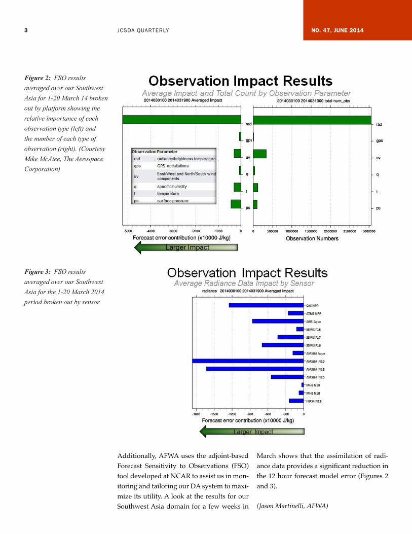
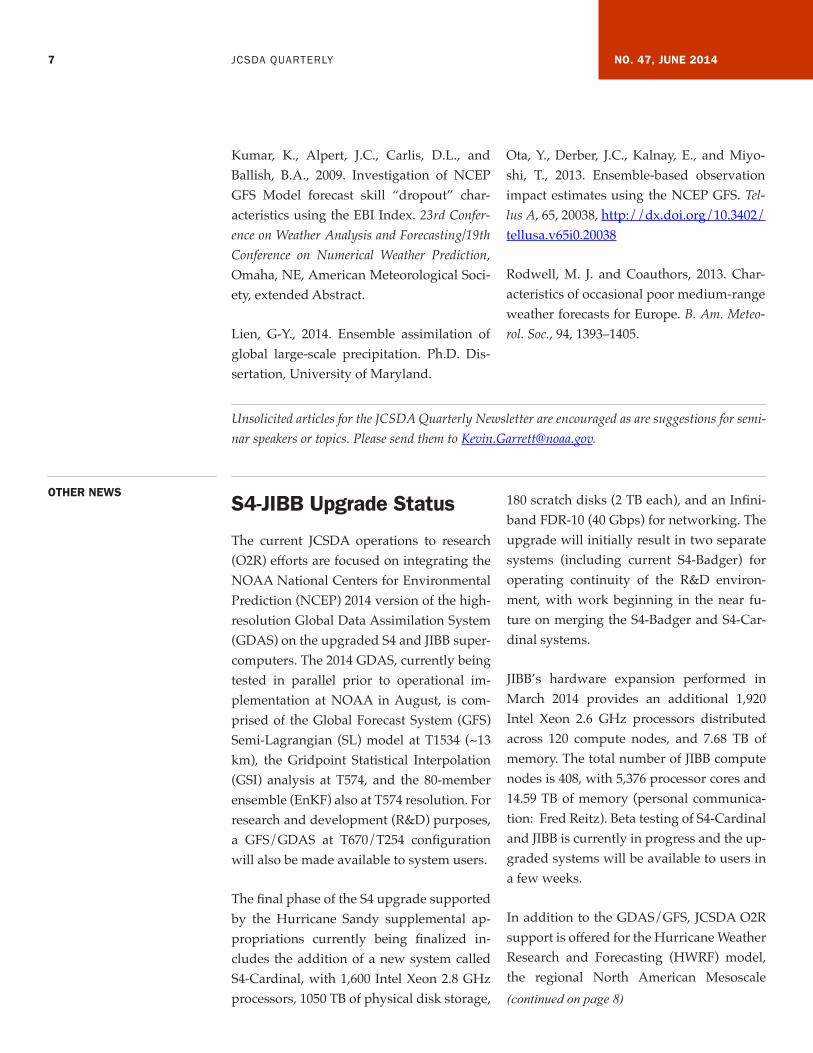
Additionally, AFWA uses the adjoint-based Forecast Sensitivity to Observations (FSO) tool developed at NCAR to assist us in mon-itoring and tailoring our DA system to maxi-mize its utility. A look at the results for our Southwest Asia domain for a few weeks in
March shows that the assimilation of radi-ance data provides a significant reduction in the 12 hour forecast model error (Figures 2 and 3).
(Jason Martinelli, AFWA)
Figure 2: FSO results averaged over our Southwest Asia for 1-20 March 14 broken out by platform showing the relative importance of each observation type (left) and the number of each type of observation (right). (Courtesy Mike McAtee, The Aerospace Corporation)
Figure 3: FSO results averaged over our Southwest Asia for the 1-20 March 2014 period broken out by sensor.

4 JCSDA QUARTERLY NO. 47, JUNE 2014
JOINT CENTER FOR SATELLITE DATA ASSIMILATION
5830 University Research Court College Park, Maryland 20740
Website: www.jcsda.noaa.gov
EDITORIAL BOARD
Editor: Kevin Garrett
Assistant Editor: Erin Jones
Support Staff: Ana Carrion René Brown
Director: Sid-Ahmed Boukabara (Acting)
Deputy Director: Sid-Ahmed Boukabara
Chief Administrative Officer: James Yoe
Proactive Quality Control in Data AssimilationThe use of satellite-based remotely sensed observations, along with the introduction of sophisticated data assimilation (DA) meth-ods that enable direct assimilation of them such as variational techniques and ensemble Kalman Filtering (EnKF), has brought dra-matic improvement to the quality of Nu-merical Weather Prediction (NWP). The av-erage six-day forecast skill of today’s NWP, for example, is more accurate than that of a three-day forecast in 1979 (the FGGE year) when satellite data were not yet assimilat-ed. Despite the very high average forecast skills, however, the current operational sys-tems occasionally suffer from abrupt drop of forecast performance (e.g., Rodwell and coauthors, 2013). In order for better op-erational reliability, therefore, NWP centers have to minimize the occurrences of such forecast skill dropouts. Recent studies by the National Centers for Environmental Predic-tion (NCEP) “Dropout Team” have shown that those dropouts occur not because of the model’s deficiencies but because of the as-similation of flawed observations that the op-erational quality control (QC) system failed to filter out (Alpert et al., 2009; Kumar et al., 2009). The major challenge in prevent-ing such dropouts resides thus in detecting those flawed observations.
A diagnostic technique called Forecast Sen-sitivity to Observation (FSO) enables us to quantify how much each observation im-proved or degraded the forecast. Our group at University of Maryland has succeeded in devising an ensemble-based formulation of FSO, which we call EFSO, and have success-fully implemented it to a quasi-operational global ensemble DA system coupled with NCEP’s GFS model (Kalnay et al., 2012; Ota
et al., 2013). While most previous FSO stud-ies, which use an adjoint-based formulation, have been predominantly concerned with statistical properties of observational im-pact, Ota et al. (2013) successfully demon-strated that it is possible, for individual cas-es, to identify flawed observations that are responsible for forecast skill dropouts by ap-plying EFSO with 24-hour forecast lead time to a relatively small horizontal region. They report that, in all the seven cases they exam-ined, rejection of the identified defective ob-servations actually improved the forecasts. Strikingly, in one of the examined cases, the regional forecast errors were reduced by as much as 30 percent.
The “Proactive QC,” our proposed new QC scheme, exploits the EFSO’s capacity to de-tect defective observations that actually de-graded forecast skill. First we perform DA using all the available observations that passed the standard operational QC. Then, 6 hours later, when the analysis at the next cycle becomes available, we compute re-gional 6-hour forecast errors and apply an algorithm to detect regional skill dropouts. We next carry out EFSO diagnostics on those de-tected regions to identify observations that are likely to have significantly degraded 6-hour forecasts. If such flawed observations are identified, we repeat the analysis with-out using the identified observations.
Concerns that need to be addressed before adapting Proactive QC into the operational system include whether it also works for the ensemble/variational hybrid DA system and whether the lead time of 6 hours is long
(continued on page 5)

5 JCSDA QUARTERLY NO. 47, JUNE 2014
enough to capture meaningful signals of the forecast errors. In order to address these issues, we have implemented the EFSO di-agnostics tool to a lower-resolution version of the operational ensemble/3D-Var hy-brid GSI and tested EFSO diagnostics with three different forecast lead times (6, 12 and 24 hours). We have found that, contrary to the concerns stated above, EFSO gives consistent results regardless of the DA sys-tem used (pure EnKF or a hybrid) and of the choice of forecast lead time, not only in terms of statistical properties but also for in-dividual cases. Figure 1 shows the impacts of observations to the forecast contributed from each type of observation for the case which Ota et al. (2013) obtained ~30 per-cent forecast improvement by denying MO-DIS winds. Positive values correspond to an increase of forecast errors (i.e., negative impacts). This figure shows that the strong negative impact from MODIS winds in this region can be clearly identified even with a lead time as short as 6 hours. This not only shows that our new QC algorithm is feasible but also corroborates the robustness of our approach.
The last and most important question to be answered is whether the rejection of
observations based on 6-hour EFSO really improves the forecast. To answer this ques-tion, we conducted data-denial experiments for 20 selected cases. In the data-denial ex-periments, the analysis and forecast are re-peated without using the observations that are identified as flawed by EFSO. As an example, we show in Figure 2 the relative forecast improvement by the rejection of the observations that are identified by 6-hour EFSO as having negative impacts, for the case shown in Figure 1. The forecast is im-proved for all of the forecast lead times (6, 12 and 24 hours), locally by as much as 45 per-cent. What is important here is that we were able to improve 24-hour forecasts by using the information that is available after only 6 hours from the analysis. In the 20 cases ex-amined, we had improvements in 13 cases and neutral impacts in 7 cases; degradation occurred in none of the 20 cases.
Our Proactive QC is a major innovation be-cause it will allow us, for the first time ever, to carry out fully flow-dependent QC based on whether the observation actually degrad-ed the forecast. Another significant outcome of our Proactive QC is that it would enable
(continued on page 6)
Figure 1. Estimated forecast error reduction contributed from each observation type for lead times of (a) 6 hours, (b) 12 hours and (c) 24 hours, for February 6, 2012, 18Z initialization. The forecast errors are measured with the moist total energy norm (unit: J kg-1) for the area of [60°N-90°N, 40°E-100°E].

6 JCSDA QUARTERLY NO. 47, JUNE 2014
us to build a detailed database of failed ob-servations by collecting all their occurrences along with relevant metadata. Such a data-base can then be provided to algorithm de-velopers to help them correct the problem that produced the bad observations and avoid them in the future. Finally, the Proac-tive QC will allow a more efficient and pre-cise determination of the optimal way to as-similate new observing systems. The current approach, based on comparisons of forecasts started from experiment and control analyses (made with and without using the new ob-servations) has difficulties obtaining statis-tically significant results in the presence of the rest of the available observing systems. The Proactive QC should address this prob-lem by finding the short-term impact of each observation and allowing the comparison of the impact of different observation algo-rithms. In fact, Lien (2014) showed, using the TRMM-retrieved global precipitation data as an example of a new observing system, that EFSO can be effectively used to sys-tematically design a data-selection strategy without which the new observing system fails to improve the forecast. Without EFSO, one would have to perform many expensive
OSE experiments through trial and error be-fore arriving at an appropriate data-selection strategy. The use of EFSO will thus allow us to greatly accelerate the development of DA methods for new observing systems.
(Daisuke Hotta, University of Maryland, Ja-pan Meteorological Agency, Eugenia Kalnay, University of Maryland, Yoichiro Ota, Japan Meteorological Agency, Guo-Yuan Lien, AICS/RIKEN)
References:Alpert, J.C., Carlis, D.L., Ballish, B.A., and Kumar, V.K. 2009. Using pseudo RAOB ob-servations to study GFS skill score drop-outs. 23rd Conference on Weather Analysis and Forecasting/19th Conference on Numerical Weather Prediction, Omaha, NE, American Meteorological Society, extended Abstract.
Kalnay, E., Ota, Y., Miyoshi, T., and Liu, J., 2012. A simpler formulation of forecast sensi-tivity to observations: application to ensem-ble Kalman filters. Tellus A, 64, 18462, http://dx.doi.org/10.3402/tellusa.v64i0.18462.
Figure 2: The relative forecast improvements by the denial of the observations that are identified as “flawed” by 6-hour EFSO. The relative forecast improvements are computed for each of the 10ox10o latitude-longitude boxes by dividing the difference of the forecast error before and after the data denial by that before the denial. The errors are measured with the moist total energy norm. Shown are the results for (a) 6-hour forecast, (b) 12-hour forecast, and (c) 24-hour forecast.
(continued on page 7)
7 JCSDA QUARTERLY NO. 47, JUNE 2014
Kumar, K., Alpert, J.C., Carlis, D.L., and Ballish, B.A., 2009. Investigation of NCEP GFS Model forecast skill “dropout” char-acteristics using the EBI Index. 23rd Confer-ence on Weather Analysis and Forecasting/19th Conference on Numerical Weather Prediction, Omaha, NE, American Meteorological Soci-ety, extended Abstract.
Lien, G-Y., 2014. Ensemble assimilation of global large-scale precipitation. Ph.D. Dis-sertation, University of Maryland.
Ota, Y., Derber, J.C., Kalnay, E., and Miyo-shi, T., 2013. Ensemble-based observation impact estimates using the NCEP GFS. Tel-lus A, 65, 20038, http://dx.doi.org/10.3402/tellusa.v65i0.20038
Rodwell, M. J. and Coauthors, 2013. Char-acteristics of occasional poor medium-range weather forecasts for Europe. B. Am. Meteo-rol. Soc., 94, 1393–1405.
OTHER NEWSS4-JIBB Upgrade Status
The current JCSDA operations to research (O2R) efforts are focused on integrating the NOAA National Centers for Environmental Prediction (NCEP) 2014 version of the high-resolution Global Data Assimilation System (GDAS) on the upgraded S4 and JIBB super-computers. The 2014 GDAS, currently being tested in parallel prior to operational im-plementation at NOAA in August, is com-prised of the Global Forecast System (GFS) Semi-Lagrangian (SL) model at T1534 (~13 km), the Gridpoint Statistical Interpolation (GSI) analysis at T574, and the 80-member ensemble (EnKF) also at T574 resolution. For research and development (R&D) purposes, a GFS/GDAS at T670/T254 configuration will also be made available to system users.
The final phase of the S4 upgrade supported by the Hurricane Sandy supplemental ap-propriations currently being finalized in-cludes the addition of a new system called S4-Cardinal, with 1,600 Intel Xeon 2.8 GHz processors, 1050 TB of physical disk storage,
180 scratch disks (2 TB each), and an Infini-band FDR-10 (40 Gbps) for networking. The upgrade will initially result in two separate systems (including current S4-Badger) for operating continuity of the R&D environ-ment, with work beginning in the near fu-ture on merging the S4-Badger and S4-Car-dinal systems.
JIBB’s hardware expansion performed in March 2014 provides an additional 1,920 Intel Xeon 2.6 GHz processors distributed across 120 compute nodes, and 7.68 TB of memory. The total number of JIBB compute nodes is 408, with 5,376 processor cores and 14.59 TB of memory (personal communica-tion: Fred Reitz). Beta testing of S4-Cardinal and JIBB is currently in progress and the up-graded systems will be available to users in a few weeks.
In addition to the GDAS/GFS, JCSDA O2R support is offered for the Hurricane Weather Research and Forecasting (HWRF) model, the regional North American Mesoscale (continued on page 8)
Unsolicited articles for the JCSDA Quarterly Newsletter are encouraged as are suggestions for semi-nar speakers or topics. Please send them to [email protected].

8 JCSDA QUARTERLY NO. 47, JUNE 2014
(NAM) with the NAM Data Assimilation System (NDAS), Hybrid Coordinate Ocean Model (HYCOM), and Land Information System (LIS) models, with planned integra-tion of current operational versions in the near future. The JCSDA Research to Dem-onstration (R2D) conduit, leading to opera-tional implementation, will involve a quality assessment of the input satellite data to the GSI and an objective assessment of both the analysis quality and impact on the forecast using a complete Independent Assessment Tools (IAT) package.
(Krishna Kumar, JCSDA, Jim Jung, University of Wisconsin-Madison, CIMSS, Scott Nolin, Jesse Stroik, University of Wisconsin-Madison, SSEC)
Call for Papers
20th Conference on Satellite Meteorology and Oceanography, 11th Symposium on New Generation Operational Environmen-tal Satellite Systems, and Third AMS Sym-posium on the Joint Center for Satellite Data Assimilation (JCSDA), 4–8 January 2015, Phoenix, Arizona
The Joint 20th AMS Satellite Conference, 11th AMS Annual Symposium on New Gen-eration Operational Environmental Satellite Systems, and Third AMS JCSDA Sympo-sium, organized by the AMS Committee on Satellite Meteorology, Oceanography and Climatology, Joint Polar Satellite System (JPSS) and Geostationary Operational Envi-ronmental Satellite R-Series (GOES-R) Sym-posium Committee, and JCSDA, will be held 4–8 January 2015, as part of the 95th AMS Annual Meeting in Phoenix, Arizona. Pre-liminary programs, registration, hotel, and general information will be posted on the
AMS website (http://www.ametsoc.org/meet/annual/) in late September 2014.
The theme for the 2015 AMS Annual Meet-ing is “Fulfilling the Vision of Weather, Water, and Climate Information for Every Need, Time, and Place.” People, business-es, and governments depend increasingly on weather, water, and climate information matched to their specific needs. We are con-verging on a day when such information is integrated into nearly every decision or ac-tion people take. This revolution in highly targeted, customized information—deliv-ered when and where it is most useful—will make our lives safer, more productive, and more enjoyable. The challenge for our com-munity is this: Collaborate and innovate to develop—and ultimately deliver—action-able, user-specific weather, water, and cli-mate information across all spatial and tem-poral scales in support of our nation’s safety, health, and prosperity. The meeting will ex-plore the many topics required for our com-munity to implement this vision.
A Joint Program Committee is soliciting ab-stracts and presentations describing new concepts, research, operations, and practical application of satellite measurements to me-teorological, oceanographic, climatological, and other environmental problems. The or-ganizers are particularly interested in papers focused on improved use of polar-orbiting and geostationary satellite data for analyz-ing and predicting the weather, the ocean, the climate, and the environment. This in-cludes research and progress on current and next-generation passive and active systems, including geostationary microwave imag-ers and hyperspectral infrared sounders,
(continued on page 9)

9 JCSDA QUARTERLY NO. 47, JUNE 2014
Doppler wind lidar, soil moisture and ocean salinity, and outcomes of various missions aimed at trace/greenhouse gases or more detailed aerosol information. Major areas of interest include:
• Factors influencing the design and opera-tion of satellites and satellite instrumenta-tion for observing the atmosphere, oceans, and the Earth
• Research/studies that assess the impact of satellite data on forecast skill
• The potential of satellite systems to pro-vide stable, accurate and systematic ob-servations of all components of the cli-mate system
• How satellite data are being used to ad-vance our understanding of fundamental weather and climate processes in the at-mosphere, oceans, land surface, and cryo-sphere, and will continue to improve our ability to observe, analyze, predict, and communicate weather and climate data at a new level of fidelity and timeliness
• Development of innovative methods of processing, combining, assimilating and analyzing the observations from satellites
• Development of remote sensing data ap-plications to support decision making in fields such as energy security, agriculture, human health, water resources and others
• What methods satellite programs use to interact with satellite data users to under-stand their vision for the use of satellite data to meet their mission requirements
• How satellite capabilities are evaluated to determine their effectiveness in meeting their users’ data requirements and how evaluation results are fed back to the user community.
Presenters are requested to please sub-mit abstracts electronically via the web by 1 August 2014 (refer to the AMS web page at https://ams.confex.com/ams/). An ab-stract fee of $95 (payable by credit card or purchase order) is charged at the time of submission (refundable only if abstract is not accepted). This fee covers the submis-sion of your abstract, the posting of your extended abstract, and the uploading and recording of your presentation, which will be archived on the AMS website.
Authors of accepted presentations will be notified via e-mail by late September 2014. All extended abstracts are to be submitted electronically and will be available online via the web. Instructions for formatting ex-tended abstracts will be posted on the AMS website. Authors have the option to submit manuscripts (up to 10 MB) electronically by 5 February 2015. All abstracts, extended ab-stracts and presentations will be available on the AMS website at no cost.
Student Award Opportunities
Based on the quality of submitted abstracts, two students will be selected for partial re-imbursement of their travel expenses, as well as two students being selected for the best oral and poster presentations submitted to this program.
Program Chair(s)
For additional information please contact one of the co-chairs of the Joint Program Committee: Derek Posselt, University of Michigan (Tel: 734-936-0502; [email protected]), Ken Carey, ERT, Inc. (Tel: 703-980-0500; [email protected]), Gary Mc-
(continued on page 10)
10 JCSDA QUARTERLY NO. 47, JUNE 2014
Williams, Goddard Space Flight Center, JPSS Program Office, (Tel: 240-684-0597; e-mail: [email protected]); Pat Kablick, University of Maryland ([email protected]), Jim Yoe, JCSDA (Tel: 301-683-
3515; [email protected]), and Chris Velden, University of Wisconsin-CIMSS (Tel: 608-262-9168; [email protected]).
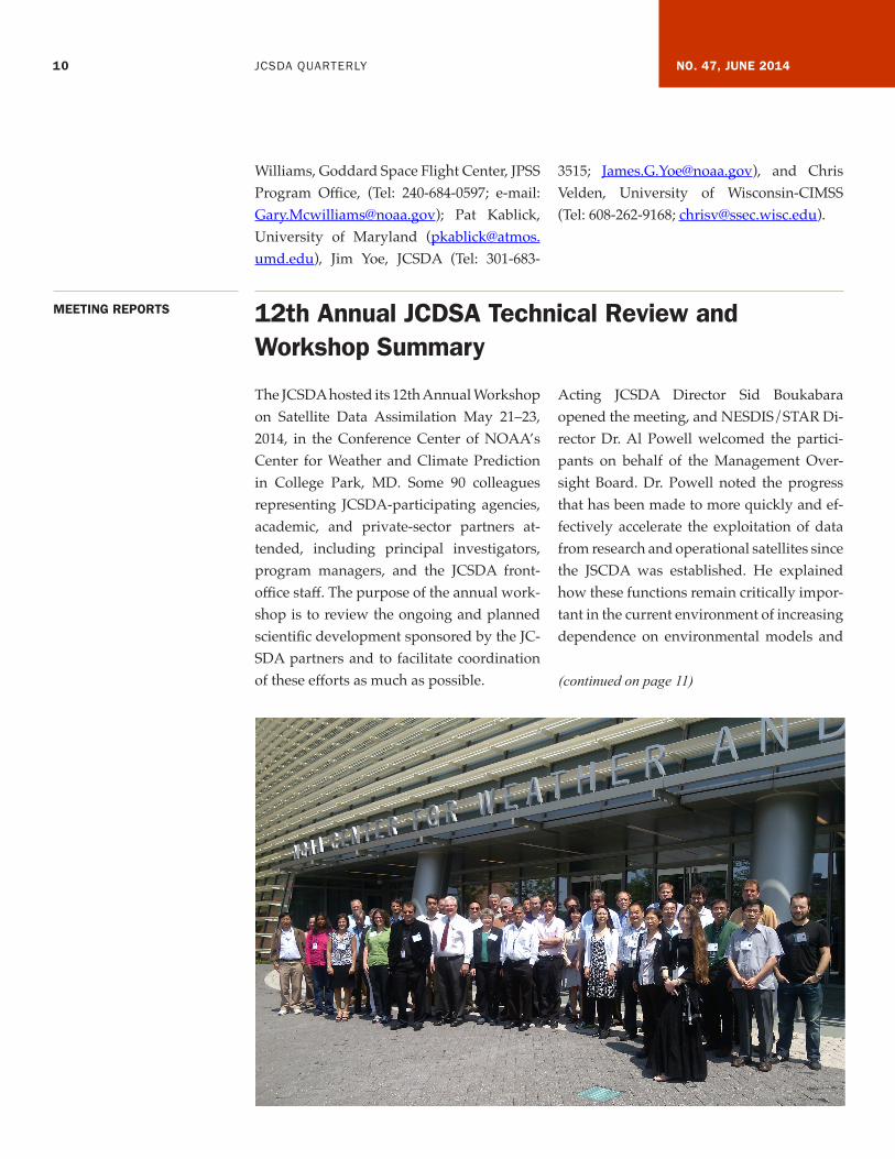
MEETING REPORTS 12th Annual JCDSA Technical Review and Workshop Summary
The JCSDA hosted its 12th Annual Workshop on Satellite Data Assimilation May 21–23, 2014, in the Conference Center of NOAA’s Center for Weather and Climate Prediction in College Park, MD. Some 90 colleagues representing JCSDA-participating agencies, academic, and private-sector partners at-tended, including principal investigators, program managers, and the JCSDA front-office staff. The purpose of the annual work-shop is to review the ongoing and planned scientific development sponsored by the JC-SDA partners and to facilitate coordination of these efforts as much as possible.
Acting JCSDA Director Sid Boukabara opened the meeting, and NESDIS/STAR Di-rector Dr. Al Powell welcomed the partici-pants on behalf of the Management Over-sight Board. Dr. Powell noted the progress that has been made to more quickly and ef-fectively accelerate the exploitation of data from research and operational satellites since the JSCDA was established. He explained how these functions remain critically impor-tant in the current environment of increasing dependence on environmental models and
(continued on page 11)
11 JCSDA QUARTERLY NO. 47, JUNE 2014
satellite data and products, flat or shrinking budgets, and growing demands for account-ability and justification for the resources de-voted to satellites and sensors.
The first session of oral presentations con-sisted of summaries of JCSDA-related ac-tivities that are ongoing within each of the six partner agencies, given by the respective Executive Team members or their delegates. These featured reports on the updates to relevant model and data assimilation sys-tems, as well as updates on advancements made with respect to specific categories of satellite data, sensors, and missions. Cer-tain programmatic topics were addressed as well, mainly those that might be expected to impact collaborations with the rest of the JC-SDA. Among these were the upgrades to the JCSDA O2R platforms and enhanced efforts to assimilate atmospheric motion vectors, geostationary imager radiances, and obser-vations affected by clouds and precipitation, all with supplemental funding via the Hur-ricane Sandy Relief Act.
There followed sessions organized around the Center’s scientific priority areas: Radia-tive Transfer, Ocean Data Assimilation, Land
Data Assimilation, Air Composition and Aerosols, Cloud and Precipitation, Global Observing Systems Assessment and Optimi-zation, and Atmospheric Data Assimilation. A total of 27 oral presentations and 22 post-ers were reviewed during these topical ses-sions. The program and all of the presenta-tions and posters are available to be viewed online by following the link: http://www.jcsda.noaa.gov/meetings_Wkshp2014.php
The Workshop closed with a wrap-up ses-sion that provided opportunities to ex-tend discussions on the science presented, whether it is optimized to meet current and evolving needs, and, in order to facilitate improvement next year, on the Workshop it-self. The format of having no parallel break-out sessions was roundly preferred both by investigators, who had more time to speak, and by the Executive Team, whose members did not have to choose between parallel pre-sentations. Suggestions for improvement in-cluded budgeting time for session wrap-up discussions and for presenting poster sum-maries before the poster viewing session
(Jim Yoe, NCEP, JCSDA Chief Administrative Officer)

12 JCSDA QUARTERLY NO. 47, JUNE 2014
PEOPLE Commander Nick Vincent Named Chairman of the Management Oversight Board for the JCSDA
Welcome Aboard, Eric Maddy
Nick joined the Navy as a Special Duty Oceanography Officer in 1994 after graduat-ing from Texas A&M University at Galves-ton with a B.S. in Marine Science. After tours of duty at the Naval Oceanographic Office at Stennis Space Center, MS, and at the Naval Atlantic Meteorology and Oceanography Facility in Jacksonville, FL, Nick earned his M.S. in Meteorology and Physical Oceanog-raphy in 2003 and his Ph.D. in Meteorology in 2006 from the Naval Postgraduate School. During his graduate work, he specialized in aerosol optical depth retrievals from high-resolution commercial satellite imagery. After graduate school, Nick served as the Ship’s Meteorologist aboard the aircraft car-rier USS George Washington, as well as tours
back at Stennis Space Center with the Fleet Survey Team and on the staff of the Com-mander, Naval Meteorology and Ocean-ography Command. Following staff duty, Nick served as commanding officer of the Naval Oceanography Antisubmarine War-fare Center in Yokosuka, Japan, providing oceanographic support to Navy ships in the Western Pacific, as well as weather support coordination for Commander, Naval Forces Japan. In 2013, Nick reported to the Office of the Oceanographer of the Navy as the Dep-uty Technical Director and was appointed to the JCSDA Management Oversight Board. Most recently, he relieved Dr. Bob Atlas as the Chairman of the Management Oversight Board in June 2014.
Eric Maddy joined the Riverside Technology, Inc. (RTi) team at NOAA/NESDIS/STAR as a Data Assimilation Scientist in support of JCSDA in March 2014. His key responsibili-ties include optimizing the usage of atmo-spheric motion vector data within the GSI and performing pre-assimilation data qual-ity assessments of new observations.
Before coming to RTi to support JCSDA, he worked as a Senior Research Scientist for the Science and Technology Corporation in NESDIS/STAR/SMCD since 2004. There, he led development and characterization of the NOAA unique retrieval algorithms, which use all-sky hyperspectral infrared (AIRS, IASI, CrIS), high spatial resolution imager (Aqua MODIS, MetOp-A AVHRR, VIIRS), and microwave sounder measure-
ments (AMSU+HSB, AMSU+MHS, ATMS) to derive atmospheric temperature, mois-ture, aerosol, and minor gas profiles. His work led to improved cloud-clearing meth-odologies that exploit high spatial resolu-tion imager measurements collocated with hyperspectral sounders, thus enabling the characterization of sub-pixel cloud infor-mation within the sounder’s field of view (FOV).
Eric holds B.S. degrees in physics and math-ematics (2001) from Frostburg State Univer-sity, Frostburg, MD, and M.S. (2003) and Ph.D. (2007) degrees in Atmospheric Physics from the University of Maryland, Baltimore County (UMBC).
(continued on page 13)

13 JCSDA QUARTERLY NO. 47, JUNE 2014
Welcome Aboard, Yingtao MaDr. Yingtao Ma recently joined Atmospher-ic and Environmental Research (AER) at NOAA/NESDIS/STAR in support of JC-SDA. He will be working on upgrading the Line-By-Line Radiative Transfer Model (LBLRTM) and its monochromatic version, the Monochromatic Radiative Transfer Code (MonoRTM), both developed by AER. The models provide the reference gaseous absorption used to develop the fast radia-tive transfer parameterizations included in the NOAA Community Radiative Transfer Model (CRTM). The project is a collabora-tive effort between AER and JCSDA.
Prior to joining AER, Yingtao was employed by the Department of Atmospheric and Oceanic Science, University of Maryland at College Park, where he worked on model-
ing, retrieving, and measuring the surface radiation budget. This included conducting research and developing algorithms for de-riving shortwave irradiances using satellite observations at various temporal and spatial scales, evaluating and analyzing solar radia-tion datasets, and setting up and managing a Baseline Surface Radiation Network (BSRN) ground observation station in Africa. Ying-tao’s educational background includes a B.S. in Electronic Physics, an M.S. in Atmospher-ic Physics, and a Ph.D. in Meteorology from the University of Maryland at College Park with a dissertation on longwave radiative transfer in 3D cloud fields.
When not at work, Yingtao enjoys many sports including badminton, soccer, hiking, and especially surfing (web surfing)!
CAREER OPPORTUNITIES Further information on career opportunities listed here may be found at http://www.jcsda.noaa.gov/careers.php
NOAA
The National Oceanic and Atmospheric Administration, Center for Satellite Applications and Research (NOAA/STAR), is currently seeking qualified candidates in support of the JCSDA. Successful candidates will join the Directed Research Team (DRT) to work on high-priority data assimilation projects, with focuses on assimilation of passive and active microwave radiance data, geostationary radiance data, and Atmospheric Motion Vectors (AMVs), as well as to support current efforts on Observing System Simulation Experiments (OSSEs) and the Community Radiative Transfer Model (CRTM) development. These are full-time, permanent positions with Riverside Technology, Inc., Atmospheric and Environmental Research, Inc., the University of Maryland, or Colorado State University, and located at the NOAA Center for Weather and Climate Prediction in College Park, MD.

14 JCSDA QUARTERLY NO. 47, JUNE 2014
The 12th Annual JCSDA Technical Review Meeting & Science Workshop was held just last week (May 21–23, 2014) as of the writ-ing of this note, here in College Park, MD. Naturally, for those of us who attended ei-ther physically or remotely, the memory is still vivid and the excitement still high as to the opportunities to work collaboratively on the science of improving and increasing the benefit of satellite data in the assimilation systems. A note summarizing the findings of the workshop and highlighting some of the excellent work presented can be found in this newsletter. I consistently have found over the years that besides offering world-class scientific presentations, the workshop provides an opportunity for interactions and scientific discussions that inspire and insti-gate new areas to explore. In order to con-tinue that and keep the momentum going, as well as to engage those who did not have a chance to attend, I would like to highlight that all presentations are on the JCSDA web-site for your convenience, so please feel free to review them, get inspired (again), reach out to the authors and collaborate.
The format of the workshop continued to evolve this year as well, with an attendance around 80 persons (either in person or via remote access). This year was the first time that we blended two modes we have been oscillating between over the years: a techni-cal review meeting format focused on close-ly linked activities relevant to JCSDA objec-tives, and a more open science workshop format open to all the research community and NWP centers involved in satellite data assimilation. This year, we also moved away from holding breakout sessions, to address a recurrent lament from the participants that they cannot be in all breakout sessions si-multaneously. Instead, additional time was
allocated for the presentations and the dis-cussions. All indications are that this format was very well received by the participants and will likely be used next year with per-haps slight tweaks to improve further.
In the spirit of promoting further coordina-tion of activities between the JCSDA part-ners and affiliates, I am pleased to report that the Executive Team is actively working on identifying technical liaisons from each of the JCSDA partners (some are already list-ed in the JCSDA website) to serve as entry points of knowledge to the JCSDA partners’ technical activities. We expect this to help tie together many of the internal and external activities, by sharing information on who is doing what in the JCSDA, by contributing to identify gaps and avoid overlaps, and per-haps more important, by helping to initiate new collaborative efforts.
Some of you might be wondering about the status of the external research program that the JCSDA tries to organize every year, on a rotating basis between NOAA’s FFO and NASA’s ROSES opportunities. Although the budget for Fiscal Year 2015 has not yet been passed by the U.S. Congress and hence the exact scope is unknown, the Executive Team is preparing for the the FY15 announcement of opportunity, with the public release ex-pected sometime this fall. The priorities for this year’s (FFO) call are being identified, in part accounting for the outcomes of the recent workshop. We look forward to con-tinuing to engage the external research com-munity through this program in FY15 and helping to improve the science used in the nation’s NWP centers, hence increasing the return on the investment made on satellite
NOTE FROM THE DIRECTOR
(continued on page 15)

15 JCSDA QUARTERLY NO. 47, JUNE 2014
data. The use of the JIBB- and S4-based O2R environments, which the JCSDA has estab-lished over the last couple of years, will be key to ensuring the success of this effort. Now more than ever, we invite our exter-nally affiliated scientists (whether funded or not by the JCSDA) to take advantage of this opportunity and demonstrate the value of their research in this environment. This is deemed a prerequisite for a potential R2O transition to be successful.
I hope that this newsletter will offer you a light yet instructive summer reading (if it
reaches you in the Northern Hemisphere, that is!) and I will conclude by mentioning that if you happen to be in the Washington, DC, area (for a conference or even for vaca-tion, but we won’t insist in this case) and you would like to give a scientific seminar to provide visibility for your satellite data assimilation-related work within the JCSDA audience, we would be happy to make that happen.
Take care,Sid Boukabara (Acting Director, JCSDA)
SCIENCE CALENDARUPCOMING EVENTS
JCSDA seminars are generally held on the third Wednesday of each month at the NOAA Center for Weather and Climate Prediction, 5830 University Research Court, College Park, MD. Presentations are posted at http://www.jcsda.noaa.gov/JCSDASeminars.php prior to each seminar. Off-site personnel may view and listen to the seminars via webcast and conference call. Audio recordings of the seminars are posted at the website the day after the seminar. If you would like to present a seminar contact [email protected].
JCSDA SEMINARS
DATE SPEAKER AFFILIATION TITLE
16 September, 2014, 2 PM
Thomas Nehrkorn and Ross Hoffman
AER Correction for Position Errors in Variational Data Assimilation
MEETINGS OF INTEREST
DATE LOCATION WEBSITE TITLE
22-26 September, 2014
Geneva, Switzerland
https://www.eumetsat.int/website/home/News/ConferencesandEvents/DAT_2076129.html
2014 EUMETSAT Meteorological Satellite Conference
4-8 January, 2015 Phoenix, AZ https://ams.confex.com/ams/95Annual/oasys.epl
3rd Symposium on the JCSDA 95th Annual Meeting of the AMS