Joint ACAC/ICAO GNSS Workshop
13
Joint ACAC/ICAO GNSS Workshop GNSS Vulnerability IATA’s Perspective Rabat 7-8 November 2017 Jehad Faqir, Deputy Regional Director Safety & Flight Operations – IATA MENA
Transcript of Joint ACAC/ICAO GNSS Workshop

Joint ACAC/ICAO GNSS Workshop GNSS Vulnerability IATA’s Perspective
Rabat 7-8 November 2017
Jehad Faqir, Deputy Regional Director Safety
& Flight Operations – IATA MENA

GNSS Use
GNSS provides position and timing information
supporting several important flight and air traffic
management (ATM) operations
GNSS is recognized as a main enabler to ICAO
PBN operations.

GNSS receiver
main source of position information which drives the
aircraft navigation system.
primary equipment supporting (RNP) operations input to:
Navigation Display (ND),
GPWS and ADS.
some business aircraft use GNSS as a reference source
for aircraft flight control and stability systems

Impact of harmful interferenceImpacts on aircraft :
loss of on-board GNSS functionality;
[GPS-L INVALID] and/or [GPS-R INVALID] messages appear;
decrease in navigation performance leading to RNP alert;
[NAV UNABLE RNP] message appears;
in some aircraft, aircraft navigation reverted to IRU or DME/DME
after GNSS loss;

Impact of harmful interference cont.
impact on Navigation Display;
a large “map shift” was observed;
impact on GPWS;
[TERR POS] and [EICAS TERRAIN POSITION] messages appear;
in certain cases, “Terrain Terrain, Pull-Up Pull-Up” aural alerts occur;
loss of auto-land and ADS reporting capabilities.

Impact of harmful interference Cont.
Noting the on-going worldwide deployments of automatic
dependent surveillance – broadcast (ADS-B),
harmful interference to GNSS will also adversely impact ATM
operations.
A degradation or complete interruption of ADS-B surveillance
services will have significant impact to ATM operations once ADS-B
is deployed as the sole mean of ATM surveillance.

MID Action to report GNSS Interference
The MID CNS SG/7 meeting (Cairo May 2016) agreed on
data collection of actual interference causes and requested
States as well as IATA to collect data using the GNSS
Interference Report Form.
IATA provided incidents reported for the 2015- 3Q .2017
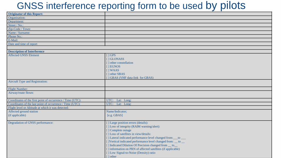
GNSS interference reporting form to be used by pilotsOriginator of this Report:
Organisation:
Department:
Street / No.:
Zip-Code / Town:
Name / Surname:
Phone No.:
E-Mail:
Date and time of report
Description of Interference
Affected GNSS Element [ ] GPS
[ ] GLONASS
[ ] other constellation
[ ] EGNOS
[ ] WAAS
[ ] other SBAS
[ ] GBAS (VHF data-link for GBAS)
Aircraft Type and Registration:
Flight Number:
Airway/route flown:
Coordinates of the first point of occurrence / Time (UTC): UTC: Lat: Long:
Coordinates of the last point of occurrence / Time (UTC): UTC: Lat: Long:
Flight level or Altitude at which it was detected:
Affected ground station
(if applicable)
Name/Indicator;
[e.g. GBAS]
Degradation of GNSS performance: [ ] Large position errors (details):
[ ] Loss of integrity (RAIM warning/alert):
[ ] Complete outage
[ ] Loss of satellites in view/details:
[ ] Lateral indicated performance level changed from:___to ___
[ ]Vertical indicated performance level changed from: __ to __
[ ] Indicated Dilution Of Precision changed from __ to__
[ ] information on PRN of affected satellites (if applicable)
[ ] Low Signal-to-Noise (Density) ratio
[ ] other

Reported Interference in MENA Region

Reported Interference in MENA Region 06/06/16 Landing 05C A330 tempo loss of GPS1 btn 6,5 IZFC dme/6,2 and 3,9/3,4
10/06/1630NM EAST OF DASIS UL333
B777 5 minAbout 30nm prior to DASIS westbound in Tehran FIR we lost GPS reception from both sensors, we checked with the aircraft around us and the four of them confirmed similar situation, The signal returned some 40nm after DASIS.
07/07/16 Landing 05C A330 GPS pos disagree
17/08/16 Landing A330 Both GPS lost on final btn 1000' and 500'.
05/09/16 Cruise level A330 10min Loss of GPS1 then GPS2
22/10/16 Cruise level B777 2 minApproximately 200nm from position Alram (Ankara/ Tehran FIR boundary) GPS indication on Nav display briefly Blanked and was replaced by INERTIAL. Shortly after crossing boundary, a repeat event occured, this time lasting for approximately two minutes
28/11/16 Cruise level 350 ft B772 4 minIn cruise FL 350, 30 NM North-West position ENEDA (Tehran FIR) on Airway UT-36 total loss of GPS signal for approximately 4 minutes (04:14UTC) Self recovered South- East ENEDA.
22/08/17 Criuse level B777 19 min
EICAS msg ADS B-OUT L annunciated. Almost immediately after R transponder was selected, ADS B-OUT R annunciated on EICAS. It was
observed concurrently that INERTIAL was displayed as navigation source on ND in place of GPS. During ensuing 15 minutes, various EICAS
messages annunciated including RAAS, RUNWAY POS, NAV UNABLE RNP, GPS, TERRAIN POS, etc. At approximately 0929z, GPS was
restored . All systems operated normally prior to and following this event.
27/08/17 Criuse level B772 40 min Loss of GPS signal in ROSTOV FIR, for approximately:40
23/10/17 Cruise level FL380 A320 5 minwithin ANK FIR, and approximately 40 miles east of waypoint BAYIR, ECAM caution ADS B Traffic and ADS B RPTG 2 were triggered
followed shortly by NAV GPS1 / NAV GPS 2 fault.
24/10/17 Cruise level A330 extended timeDuring both sectors DOH BEY and BEY DOH. From area around 37.23N 038.50E and for the rest of LTAA FIR complete loss of GPS signal
was experienced. On the first sector the problem was present until landing at BEY. On the return sector the issue was recovered when entering
OIIX FIR at position ALRAM. 4 other aircraft notified the ATC of same problem
25/10/2017 Cruise level FL370 A320 5 min NAV GPS1 Fault ECAM warning was triggered while overflying Ankara FIR close to EZS VOR.
Date Flight ACFT Duration Remark

Impact of Interference in MENA Region
reports of GNSS interference resulted in sever impact to
operations
Long duration of signal loss 40 min .
RNAV approach procedures suspended in one of the
airport

Conclusion
IATA express a strong concern on the operational impact of
interference to GNSS (30 incidents in MID Region)
Support ICAO for its on going efforts in developing and
implementing GNSS mitigation plan/measures.

29 October 2017Name of Project 13