jj3 new johannessen - Earth Online - ESA · Johnny A. Johannessen ......
39
MERSEA Strand-1 MARINE ENVIRONMENT AND SECURITY IN THE EUROPEAN AREA Johnny A. Johannessen Nansen Enviromental and Remote Sensing Center Bergen, Norway With contribution from Nadia Pinardi, Ian Robinson, Pierre-Yves Le Traon, Kostas Nittis, Mike Bell, Laurence Crosnier 2nd ENVISAT Summer School, ESA-ESRIN, 16-26 August 2004
Transcript of jj3 new johannessen - Earth Online - ESA · Johnny A. Johannessen ......

MERSEA Strand-1MARINE ENVIRONMENT AND SECURITY IN THE EUROPEAN AREA
Johnny A. JohannessenNansen Enviromental and Remote Sensing Center
Bergen, Norway
With contribution from Nadia Pinardi, Ian Robinson,Pierre-Yves Le Traon, Kostas Nittis, Mike Bell,
Laurence Crosnier
2nd ENVISAT Summer School, ESA-ESRIN, 16-26 August 2004

MARINE ENVIRONMENT AND SECURITY IN
THE EUROPEAN AREA - MERSEA STRAND-1
PartnersNansen Environmental and Remote Sensing Center, Norway, Collecte Localisation Satellites, France, Southampton Oceanography Centre, UK, Institut Francais de Recherche et d´Exploitation de la Mer, France, National Centre for Marine Research, Greece, The Danish Meteorological Institute, Denmark, The UK Met Office, UK, Instituto Nazionale di Geofisica e Vulcanologia, Italy, Department of Fisheries and Marine Research, Cyprus, Norwegian MeteorologicalInstitute, Norway, Institute of Marine Research, Norway, Proudman Oceanographic Laboratory, UK, Plymouth Marine Laboratory, UK, Météo-France , France, MERCATOR, France, Deutsches Zentrum für Luft- und Raumfahrt e.V.,Germany, The Finnish Institute of Marine Research, Finland, The Centre for Environment, Fisheries & Aquaculture Science, UK, Laboratoire d’Etudes en Géophysique et Océanographie Spatiale, France
MERSEA Strand-1 Approach
Objectives -a) deliver information products (physical, chemical and
biological) needed by users concerned with European marine environment and security policies;
b) report on the problems met and lessons learnt in supplying this information, and
c) contribute to improved knowledge, methods and tools required for monitoring, information production and delivery to users.
Surface DriftersMoored Buoys
Ship ObservationsProfiling Floats
SATELLITES
+
+MODELS
EUROCEAN 2004, Galway, Ireland, Slide 1
http://www.nersc.no/~mersea & http://www.mersea.eu.org/

MARINE ENVIRONMENT AND SECURITY IN
THE EUROPEAN AREA - MERSEA STRAND-1
Integrated System Relevance for SocietyMonitoring and protection of the marine environment in Europe concerns a wide range of international bodies, treaties, conventions and organisations at regional and national levels.
Convention of the Law of the Sea in 1982, MARPOL 73/78
London Dumping Convention 72OSPARCOM, HELCOM, BARCELONE
Framework for oil pollution response-OPRC90 European Maritime Safety Agency (EMSA)
The overarching goal is to establish a sound balance between economic and social benefit on one hand and acceptable environmental impact on the other hand.
MERSEA Strand-1 contributes to the provision of marine environmental information that is needed to establish this balance. It moreover undertakes the necessary preliminary measures towards implementation and operation of a European global operational oceanography system in the context of GMES by 2008.
EUROCEAN 2004, Galway, Ireland, Slide 2
Surface DriftersMoored Buoys
Ship ObservationsProfiling Floats
SATELLITES
+
+MODELS

MERSEA STRAND-1 takes on the way to
OPERATIONAL OCEANOGRAPHY:the backbone for provision of routine data and
information in HINDCAST-NOWCAST-FORECAST mode for
• Climate research and prediction • Marine security (crisis management)• Regular and rapid marine environment assessment• Fisheries• Management of shelf/coastal areas• Offshore industry• Coast Guard and Navy applications• Policy and Decision Making
MERSEA S-1 AN IMPORTANT KEY TO MARINE GMES

SATELLITE OBSERVATION
JASON,EnvisatNOAA,
SeaWiFS
MERCATOR, TOPAZ, FOAM &
MFSTEP
IN SITU OBSERVATION
CORIOLIS,Argo
MERSEA Strand-1 Approach
………………BARENTS SEA BALTIC SEASKAGERRAKNORTH SEACHANNELIRISH SEABISCAYIBERIAN SEA BLACK SEAAEGEAN SEAADRIATIC SEA…………….
ATMOSPHERIC FORCING
OBSERVING SYSTEMS MODELLING SYSTEMS

ATL-OI Cooper&Haines
-SLA MODAS Maps
-MSSH from 1/12°MICOM (ECMWF)
-3 hourly NOGAPS forcing -KPP-relaxation to Levitus SSS-relaxation to MODAS SST ana.-monthly river runoff
-Horiz 1/12° (6.5km)26 hybrid layers
Free surface
HYCOM 2.1
- no ice model
HYCOM US
MED-OI SOFA
-SLA along track once aweekSST maps once a weak-T profiles once a week
-MSSH from previous run
-6 Hourly ECMWF forcingcst vertical mixing+vertical adjustment-relaxation to satellite night time SST and SSS climatology-N0 river runoff
-horiz. 1/8°31 levels
-Z coord./Rigid Lid
MOM
- no ice model
MFS IT
ATLMED
-OI Cooper&Haines-SLA along track-SST 2.5° griddedARGO once a day.-gridded ice conc.
-MSSH from previous run
-6 Hourly NWP-MetOffice forcing-Kraus -Turner-Weak relaxation to Levitus SST and SSS.-No river runoff
-horiz. 1/9° (12km)20 levels
-Z coord./Rigid Lid
HADLEY CENTRE
-dyn./thermodynamic sea ice
FOAM UK
ATL-OI EnKF
-SLA Maps once a week-SST maps once aweek-Maps of ice concentration
-MSSH from OCCAM run
-6 hourly ECMWF forcing-KPP mixing
-Relaxation to Levitus SSS-No river runoff
-horiz. 20 to 30km22 hybrid layers
Free surface
HYCOM
-dyn./thermodynanic sea ice
TOPAZ NO
ATLMED
-OI Cooper&Haines
-SLA along track
-MSSH from Rio et al.(data)
-Daily ECMWF forcing-TKE-Relaxation to Reynolds SST and Reynaud SSS-Monthly river runoff
-horiz. 1/15° (5-7km)43 levels
Z-coordinate/Rigid Lid
OPA
-Simple thermo. ice model
MERCATOR FR
MODEL TYPES RES.+COORD. ATM. FORCING ASS. SCHEME AREA

Metrics have been defined• Fields provided : Daily mean Best Estimate + (T0+6) forecast.• Time period : From JUNE 2003 on.• 2 BASINS : Atlantic + Mediterranean Sea
• CLASS1 T,S,U,V,SSH,MLD,BSF,TX,TY,Qtot,E-P-R.
Interpolation (non conservative) on 1/8° horizontal gridwith 12 vert. levels in ATL (5;30;50;100;200;400;700;1000;1500;2000;2500;3000m)
8 vert. levels in MED (5;30;50;100;200;500;1000;2000m).
• CLASS2 High resolution(T,S,U,V) sections/moorings.
• CLASS3 Integrated quantities: daily transports through sections/MHT/Overturning.
• CLASS4 Diagnostics to test assimilation method performance

•DATA STORED ON OPENDAP SERVERShttp://opendap.mercator-ocean.fr/dodsC/http://www.sincem.unibo.it:8080/dodsC/http://www.nerc-essc.ac.uk:9090/http://mersea.nersc.no/dodsC/http://hycom.rsmas.miami.edu/dodC/
•LAS (Live Access Server)•DODS/MATLAB or DODS/IDL>> loaddods('http://www.nerc-essc.ac.uk:9090/FOAM_NAT?temperature[0][0]') Reading: http://www.nerc-essc.ac.uk:9090/FOAM_NATL_120_8th_ARCConstraint: temperature[0][0] Server version: catalogaggserver/0.8Creating matrix temperature (1 x 1 x 441 x 869) with 383229 elements.Creating vector time with 1 elements.Creating vector depth with 1 elements.Creating vector latitude with 441 elements.Creating vector longitude with 869 elements.
•Available : CLASS1 + CLASS2 + CLASS3•working on CLASS4

CLASS1 July mean salinity at 3000m depth (ci=0.05psu)
MERCATOR
LEVITUS01
TOPAZ
FOAM
MERCATOR
TOPAZ
FOAM
HYCOM-US
DRIFT from SPIN UP length
Levitus01

mean SSH (ci=0.1m) (BASIN MEAN SSH SUBTRACTED)
MERCATOR
FOAM
TOPAZ
HYCOM new

CLASS 2 in the Atlantic

StJohn DuckpieBasques CharlestonHalifax FortPulaskiNewport SettlementAtlantic SanJuan
NO SLA ASSIMILATION IN COASTAL ZONES
SLA Comparison with Sea Level gaugeMERCATORFOAMTOPAZHYCOMTIDE GAUGE

Newlyn LerwickStornoway
Comparison with tide gauge
MERCATORFOAMTOPAZHYCOMTIDE GAUGE

Zonal Section 26°N Salinity
MERCATOR
TOPAZ
FOAM
HYCOM
WOCE A05 JUL AUG 1992
WOCE A01 JAN FEB 1998

50-200m
200-700m
In situ Argo salinity profile available from 10-2003 to 12-2003

Class2 Zonal Section 26°N Salinity
WOCEWOCE A01 JAN FEB 1998
IMPACT OF ASSIMILATION OF ARGO SALINITY PROFILE
FOAM (DEC20 2003)After assimilationof ARGO salinity profiles
assimilation of ARGO salinity profiles from DEC17 2003 on
FOAM (DEC15 2003)Before assimilationof ARGO salinity profiles
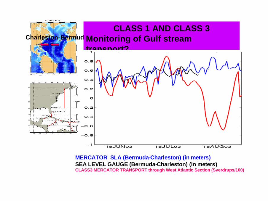
Charleston-BermudaCLASS 1 AND CLASS 3
Monitoring of Gulf stream transport?
MERCATOR SLA (Bermuda-Charleston) (in meters)SEA LEVEL GAUGE (Bermuda-Charleston) (in meters)CLASS3 MERCATOR TRANSPORT through West Atlantic Section (Sverdrups/100)

ConclusionMERSEA web site: www.mersea.eu.org
ConclusionMERSEA web site: www.mersea.eu.org
• 1st time such an inter-comparison exercise is conducted on 5 Ocean forecast systems.
• Metrics definition+OPENDAP+LAS technology = efficient inter-comparison strategy.
• Class1-2-3 ready. Working on Class4.• Strength and weakness shown. Upgrades of each
system to improve results.• So far: Atlantic + Mediterranean basins. Soon Global
ocean.• Mersea IP - GODAE metrics for Pacific/Indian/Austral
Oceans : same definiton used.

3 applications – 11 demonstration cases
Oil SpillsEutrophication
HAB

FROM BASIN SCALE VIA REGIONAL TO LOCAL SCALE MODEL CAPACITY

Short simulations :Validation on 17 november 17th, 11h
utcMOTHY operational version MOTHY + Mercator 103m
In green, areas where the use of Mercator currents in MOTHY seems to improve the forecast In red, the operational version of MOTHY seems to be better.

Long simulations :Validation on December 13th
MOTHY is a little bit late. The addition of the Mercator current at 103m seems to improve the Forecast as well as the FOAM current at 96m.

Long simulations :Validation on February 4th
MOTHY correctly simulates the beaching of the oil released on November 19th as well as MOTHY+Mercator and MOTHY+FOAM. Beaching were observed from 43°20’N to 44°30’N.

Long simulations :Validation on March 18th
MOTHY + Mercator 103m
MOTHY opérationnel = observations
MOTHY is still a little late . The two observations close to thecoast are correctly simulated by MOTHY+Mercator. However, the Prestige pollution did not reach the Ushantbefore the first days of May. MOTHY+Mercator is thereforein advance after 4 months of simulation.

Oil spill model: met.no OD3D
Atmos. data: ECMWF
Wave data: met.no WAM
subsurfacestranded_
surface
Ocean data: Mercator daily snapshots
Ocean data: Mercator daily means
NPrestigeÓ: oil spill model state15.01.03 00 utc
Only oil leaked from sunken wreck
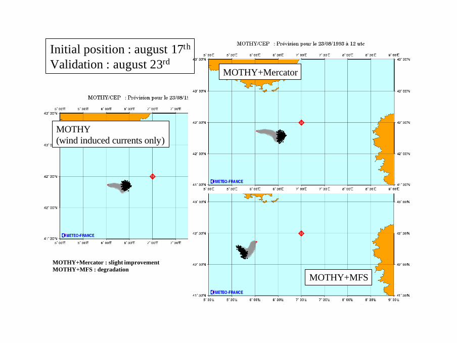
MOTHY (wind induced currents only)
MOTHY+Mercator
MOTHY+MFS
MOTHY+Mercator : slight improvementMOTHY+MFS : degradation
Initial position : august 17th
Validation : august 23rd

Initial position : august 23rd
Validation : september 5th
MOTHY+MFS
MOTHY+Mercator
MOTHY(wind induced currents only)

Integrated Monitoring and Forecasting Systems
Observations
Weather and Waves forecasts
Circulation Forecasts
Oil drift Forecasts
Example: Poseidon System
Oil slick detected in the Ionian Sea
10 days forecast of oil drift
We can combine the SAR detection capabilities with an Integrated monitoring/ forecasting system in order to predict the risk for coastal areas
QuickTime™ og enCinepak-dekomprimerer
kreves for å se dette bildet.

RESULTS: SST-CURRENT MONITORING WITH DOWNSCALING: North Sea Case
TOPAZSST
TOPAZSSH
http://moncoze.met.no/

Oil spills detected over the North Sea for the year 2000 by analyzing about 2800 ERS 2 frames.
600 spills detected.
OIL SPILL MONITORING BY SATELLITE SAR FOR THE NORTH SEA + SKAGERRAK

Coupled Physics-Ecosystem Model
3D Baroclinic Hydrodynamics
Pelagic Model
Benthic Model
Wind Stress
Heat Flux
Irradiation
Cloud Cover
River Inputs
Bo
un
dar
yC
on
dit
ion
s
C,N, P,Si
Detritus
Meio-benthos
AnaerobicBacteria
AerobicBacteria
DepositFeeders
Phyto-plankton
Nutrients
PelagicSuspensionFeeders
Detritus
NutrIents
OxygenatedLayer
Reduced Layer
RedoxDiscontinuity
Layer
Phytoplankton
Zooplankton
Pico- Flagellates Diatoms
Dissolved
Particulates
Bacteria
Micro- Meso-Hetero-trophs
Small Cells Large Cells
Si
NH4
NO3
PO4
CO2
Organics
Nutrients
SedS,T,SPM,K,u,v,w
ERSEM

RESULTS: ALGAE BLOOM MONITORING WITH DOWNSCALING 6
KMCHLOROPHYLL MAP 6 KM
CHLOROPHYLL MAP2 KM
FOAMSST MAP 12 KM
SHIPS
BUOYS
SATELLITES

LESSONS LEARNED
SATELLITEDATA
Altimeers. Ok to 2007. Then a mesoscale altimeter mission is at least needed to complementJason-2 and to constrain the mesoscale variability and open ocean currents.Infrared radiometers. Ok to 2007. Then high quality and high resolution SST measurementsfrom combined use of passive microwave and infrared radiometers are needed.Spectrometers. Ok to 2007. Then high-resolution measurements of chlorophyll served innear-real time are needed for validation or assimilation into marine biogeochemical models.SAR. Ok to 2007. Then new SAR missions are highly needed as a source of information fordetection of oil spills both from illicit vessel discharges and major accidents.

J1E2TPG2J1E2TP
J1E2J1
EKE (EKE (Pascual Pascual et al., 2004)et al., 2004)

LESSONS LEARNED
SATELLITEDATA
Altimeers. Ok to 2007. Then a mesoscale altimeter mission is at least needed to complementJason-2 and to constrain the mesoscale variability and open ocean currents.Infrared radiometers. Ok to 2007. Then high quality and high resolution SST measurementsfrom combined use of passive microwave and infrared radiometers are needed.Spectrometers. Ok to 2007. Then high-resolution measurements of chlorophyll served innear-real time are needed for validation or assimilation into marine biogeochemical models.SAR. Ok to 2007. Then new SAR missions are highly needed as a source of information fordetection of oil spills both from illicit vessel discharges and major accidents.
IN SITUDATA
VOS, Ferry-boxes and data transmission: Data from VOS and ferry boxes along Europeancoastal and shelf seas should significantly increase, and adapt to rapid data transfer.Observatories: Integrated observatories including HF radars at selected “tie-points” alongEuropean coastal and regional seas are needed for routine and sustained in-situ monitoring.Biogeochemical sensor development: There is a developing need to be able to measurepigments, nutrients, dissolved gases and other biogeochemical properties in the sea.River discharges: There is an urgent requirement for a routine monitoring system of riverdischarges (volume and nutrients) into coastal seas.

Overview on the Ferry Lines and FerryBoxes in the European FerryBox Project

HF RADAR - SKAGERRAK

LESSONS LEARNED
Marine GMES: The ocean monitoring and modelling system will not be adequate for severalmajor applications without a high-inclination alt imeter to complement Jason-2 beyond 2007.Downscaling: The regional high resolution forecasting systems improves with systematic andreliable information on the open boundaries from global and basin scale systems.Coastal Models: Coastal models are far from being developed and operated at the adequateresolution for applications to pollution monitoring from land sources.Ecosystem modelling: There is a strong need to develop and advance the maturity ofecosystem modelling.
MODELS
SATELLITEDATA
Altimeers. Ok to 2007. Then a mesoscale altimeter mission is at least needed to complementJason-2 and to constrain the mesoscale variability and open ocean currents.Infrared radiometers. Ok to 2007. Then high quality and high resolution SST measurementsfrom combined use of passive microwave and infrared radiometers are needed.Spectrometers. Ok to 2007. Then high-resolution measurements of chlorophyll served innear-real time are needed for validation or assimilation into marine biogeochemical models.SAR. Ok to 2007. Then new SAR missions are highly needed as a source of information fordetection of oil spills both from illicit vessel discharges and major accidents.
IN SITUDATA
VOS, Ferry-boxes and data transmission: Data from VOS and ferry boxes along Europeancoastal and shelf seas should significantly increase, and adapt to rapid data transfer.Observatories: Integrated observatories including HF radars at selected “tie-points” alongEuropean coastal and regional seas are needed for routine and sustained in-situ monitoring.Biogeochemical sensor development: There is a developing need to be able to measurepigments, nutrients, dissolved gases and other biogeochemical properties in the sea.River discharges: There is an urgent requirement for a routine monitoring system of riverdischarges (volume and nutrients) into coastal seas.

Need for improvement (cont.)Model resolution; enhanced resolution in the vertical and horizontal to obtain reliable simulations - global model at 10 km combined with nesting;
1/3° (PSY1) 1/15° (PSY2)
MERCATOR
African Upwelling SST+VEL.


![A Dimensions: [mm] B Recommended land pattern: [mm] D ...2012-12-06 2012-10-24 2012-08-08 2012-06-28 2012-03-12 DATE SSt SSt SSt SSt SSt SSt BY SSt SSt BD BD SSt DDe CHECKED Würth](https://static.fdocuments.us/doc/165x107/60f984e176666848374d15c0/a-dimensions-mm-b-recommended-land-pattern-mm-d-2012-12-06-2012-10-24.jpg)