Jerusalem - passia.org filefocused on ‘secretly’ infiltrating Arab neighborhoods as well as...
24
INTRODUCTION Throughout history, Jerusalem has thrived as an important political and cultural center and as a religious focal point for the three monotheistic religions. This status has resulted in numerous struggles taking place in an attempt to possess this significant city. From the outset of the occupation in 1967, successive Israeli governments have zealously and incessantly pursued one ma- jor goal, namely, the ‘Judaization’ of East Jerusalem, a policy of changing its Arab character and creating a new geopolitical reality in order to guarantee territorial, demographic, and re- ligious control over all of city. They have shared their pursuit of this goal with various settler groups, and while the former has concentrated on expropriating Palestinian land and build- ing large, ‘official’ settlements in East Jerusalem, the latter have focused on ‘secretly’ infiltrating Arab neighborhoods as well as archaeological sites in and around the Old City, their motiva- tion being both messianic and nationalistic in nature. It was during the Camp David II talks held in July 2000 that Jerusalem was for the very first time placed on the negotia- tion table. Agreement, however, was not forthcoming, and Je- rusalem consequently remains at the heart of the Arab-Israeli conflict and one of the most complex issues still awaiting a just solution. However, recent years have seen an increase in the number of Israel’s elaborate geopolitical strategies to consoli- date its exclusive sovereignty over Jerusalem. Therefore, the parameters of a political division of the city that Bill Clinton laid out (“What is Arab should be Palestinian,” and “what is Jewish should be Israeli”) become meaningless. In the months following the November 2007 Annapolis confer- ence, Israeli construction in Jerusalem and beyond its bounda- ries significantly accelerated and increased - often through or in close cooperation with settler organizations. Out of a total of approximately 470,000 settlers in the occupied Palestinian Territories, 40% - or 190,000 - are currently living in East Jeru- salem, with another 96,000 in settlements around Jerusalem. A Peace Now report released in March 2009 shows that Israel plans to build 5,722 new housing units in East Jerusalem alone. In addition, recent Peace Now calculations have shown that almost 2,000 settlers now live in outposts in the heart of the Palestinian neighborhoods of East Jerusalem. This bulletin describes current Israeli plans, trends and under- takings in Jerusalem. It provides the facts, figures, means and policies employed by Israel to strengthen its grip on the city. It shows how Israel is trying to exclude Jerusalem from any future negotiations by making sure that the city can never be “divided” along any lines, and hindering any Palestinian plans to develop East Jerusalem and declare it the capital of a future Palestinian state. While the focus of the bulletin is on settlement related top- ics, it should be noted that Israel’s ongoing efforts at foiling diplomacy are further aided by its discriminatory residency rights and housing policies, closure and permit regime, as well as house demolitions and the separation barrier. June 2009 JERUSALEM Israeli Settlement Activities & Related Policies PASSIA Palestinian Academic Society for the Study of International Affairs, Jerusalem Tel: +972-2-6264426, Fax: +972-2-6282819, E-mail: [email protected] , Website: www.passia.org , PO Box 19545, Jerusalem Contents: 2 The Old City .............................................................. 5 The Old City’s Environs and the “Holy Basin” Area .............................................................................. 9 The “Holy Basin” area beyond the Old City ....... 11 Building New and Expansion of Settlements Within the Municipal Boundaries........................... 12 Overview Map ............................................................ 16 The Settlement Enterprise Beyond the Municipal Boundaries (‘Greater Jerusalem’) ........................... 19 Other Related Policies and Plans ........................... Map: Jan de Jong, 2000 Abu Dis Deir Yassin Malha Ein Karim Beit Safafa Beit Hanina Qalandia Airport Sur Baher Shu'fat Old City Ramallah Bethlehem Jerusalem 0 5 km Jerusalem’s Municipal Boundaries, 1947-2000
-
Upload
hoangquynh -
Category
Documents
-
view
214 -
download
0
Transcript of Jerusalem - passia.org filefocused on ‘secretly’ infiltrating Arab neighborhoods as well as...

IntroductIon
Throughout history, Jerusalem has thrived as an important political and cultural center and as a religious focal point for the three monotheistic religions. This status has resulted in numerous struggles taking place in an attempt to possess this significant city.
From the outset of the occupation in 1967, successive Israeli governments have zealously and incessantly pursued one ma-jor goal, namely, the ‘Judaization’ of East Jerusalem, a policy of changing its Arab character and creating a new geopolitical reality in order to guarantee territorial, demographic, and re-ligious control over all of city. They have shared their pursuit of this goal with various settler groups, and while the former has concentrated on expropriating Palestinian land and build-ing large, ‘official’ settlements in East Jerusalem, the latter have focused on ‘secretly’ infiltrating Arab neighborhoods as well as archaeological sites in and around the Old City, their motiva-tion being both messianic and nationalistic in nature.
It was during the Camp David II talks held in July 2000 that Jerusalem was for the very first time placed on the negotia-tion table. Agreement, however, was not forthcoming, and Je-rusalem consequently remains at the heart of the Arab-Israeli conflict and one of the most complex issues still awaiting a just solution. However, recent years have seen an increase in the number of Israel’s elaborate geopolitical strategies to consoli-date its exclusive sovereignty over Jerusalem. Therefore, the parameters of a political division of the city that Bill Clinton laid out (“What is Arab should be Palestinian,” and “what is Jewish should be Israeli”) become meaningless.
In the months following the November 2007 Annapolis confer-ence, Israeli construction in Jerusalem and beyond its bounda-ries significantly accelerated and increased - often through or in close cooperation with settler organizations. Out of a total of approximately 470,000 settlers in the occupied Palestinian Territories, 40% - or 190,000 - are currently living in East Jeru-salem, with another 96,000 in settlements around Jerusalem. A Peace Now report released in March 2009 shows that Israel plans to build 5,722 new housing units in East Jerusalem alone. In addition, recent Peace Now calculations have shown that almost 2,000 settlers now live in outposts in the heart of the Palestinian neighborhoods of East Jerusalem.
This bulletin describes current Israeli plans, trends and under-takings in Jerusalem. It provides the facts, figures, means and policies employed by Israel to strengthen its grip on the city. It shows how Israel is trying to exclude Jerusalem from any future negotiations by making sure that the city can never be “divided” along any lines, and hindering any Palestinian plans to develop East Jerusalem and declare it the capital of a future Palestinian state.
While the focus of the bulletin is on settlement related top-ics, it should be noted that Israel’s ongoing efforts at foiling diplomacy are further aided by its discriminatory residency rights and housing policies, closure and permit regime, as well as house demolitions and the separation barrier.
June
200
9 JerusalemIsraeli Settlement Activities & Related Policies
PASSIA Palestinian Academic Society for the Study of International Affairs, Jerusalem
Tel: +972-2-6264426, Fax: +972-2-6282819, E-mail: [email protected] , Website: www.passia.org , PO Box 19545, Jerusalem
Contents:
2The Old City ..............................................................
5The Old City’s Environs and the “Holy Basin” Area ..............................................................................
9The “Holy Basin” area beyond the Old City .......
11Building New and Expansion of Settlements Within the Municipal Boundaries...........................
12Overview Map ............................................................
16The Settlement Enterprise Beyond the Municipal Boundaries (‘Greater Jerusalem’) ...........................
19Other Related Policies and Plans ...........................
Map: Jan de Jong, 2000
Abu Dis
DeirYassin
Malha
EinKarim
BeitSafafa
BeitHanina
QalandiaAirport
SurBaher
Shu'fat
Old City
Ramallah
Bethlehem
Jerusalem
0 5 km
Municipal Area of Jerusalem Since 1967 (in thousand dunums)
(Source: Statistical Yearbook of Jerusalem, 2000.)
Jerusalem’s Municipal Boundaries, 1947-2000
2
JerusalemIsraeli Settlement Activities & Related Policies
the old cIty
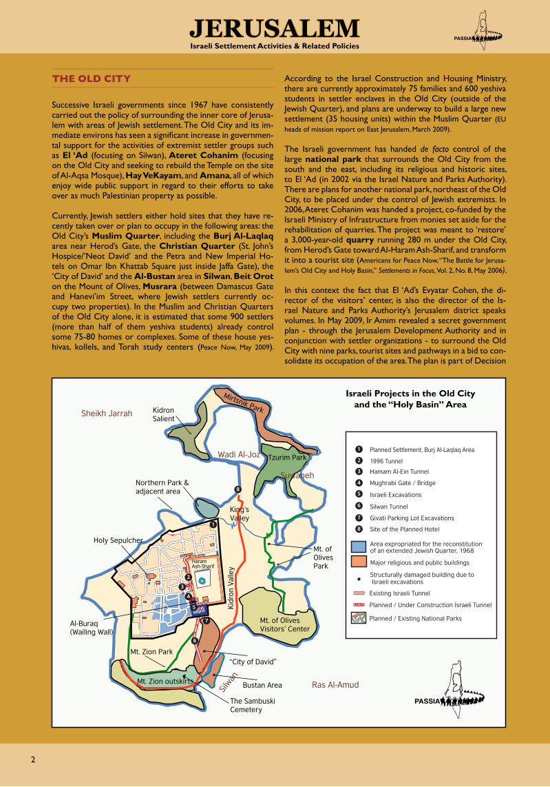
Successive Israeli governments since 1967 have consistently carried out the policy of surrounding the inner core of Jerusa-lem with areas of Jewish settlement. The Old City and its im-mediate environs has seen a significant increase in governmen-tal support for the activities of extremist settler groups such as El ‘Ad (focusing on Silwan), Ateret Cohanim (focusing on the Old City and seeking to rebuild the Temple on the site of Al-Aqsa Mosque), Hay VeKayam, and Amana, all of which enjoy wide public support in regard to their efforts to take over as much Palestinian property as possible.
Currently, Jewish settlers either hold sites that they have re-cently taken over or plan to occupy in the following areas: the Old City’s Muslim Quarter, including the Burj Al-Laqlaq area near Herod’s Gate, the Christian Quarter (St. John’s Hospice/’Neot David’ and the Petra and New Imperial Ho-tels on Omar Ibn Khattab Square just inside Jaffa Gate), the ‘City of David’ and the Al-Bustan area in Silwan, Beit Orot on the Mount of Olives, Musrara (between Damascus Gate and Hanevi’im Street, where Jewish settlers currently oc-cupy two properties). In the Muslim and Christian Quarters of the Old City alone, it is estimated that some 900 settlers (more than half of them yeshiva students) already control some 75-80 homes or complexes. Some of these house yes-hivas, kollels, and Torah study centers (Peace Now, May 2009).
According to the Israel Construction and Housing Ministry, there are currently approximately 75 families and 600 yeshiva students in settler enclaves in the Old City (outside of the Jewish Quarter), and plans are underway to build a large new settlement (35 housing units) within the Muslim Quarter (EU heads of mission report on East Jerusalem, March 2009).
The Israeli government has handed de facto control of the large national park that surrounds the Old City from the south and the east, including its religious and historic sites, to El ‘Ad (in 2002 via the Israel Nature and Parks Authority). There are plans for another national park, northeast of the Old City, to be placed under the control of Jewish extremists. In 2006, Ateret Cohanim was handed a project, co-funded by the Israeli Ministry of Infrastructure from monies set aside for the rehabilitation of quarries. The project was meant to ‘restore’ a 3,000-year-old quarry running 280 m under the Old City, from Herod’s Gate toward Al-Haram Ash-Sharif, and transform it into a tourist site (Americans for Peace Now, “The Battle for Jerusa-lem’s Old City and Holy Basin,” Settlements in Focus, Vol. 2, No. 8, May 2006).
In this context the fact that El ‘Ad’s Evyatar Cohen, the di-rector of the visitors’ center, is also the director of the Is-rael Nature and Parks Authority’s Jerusalem district speaks volumes. In May 2009, Ir Amim revealed a secret government plan - through the Jerusalem Development Authority and in conjunction with settler organizations - to surround the Old City with nine parks, tourist sites and pathways in a bid to con-solidate its occupation of the area. The plan is part of Decision
Northern Park & adjacent area
Tzurim Park
Mirtsnik ParkKidron Salient
King’s Valley
Mt. of Olives Park
Mt. of Olives Visitors’ Center
The Sambuski Cemetery
Mt. Zion Park
Al-Buraq(Wailing Wall)
Holy Sepulcher
Ras Al-Amud
Suwaneh
Silw
an
Wadi Al-Joz
Sheikh Jarrah
Mt. Zion outskirts
“City of David”
Bustan Area
Kid
ron
Val
ley
1
2
3
4
5
6
Area expropriated for the reconstitution of an extended Jewish Quarter, 1968
Major religious and public buildings
Structurally damaged building due to Israeli excavations
Existing Israeli Tunnel
Planned / Under Construction Israeli Tunnel
Planned / Existing National Parks
Planned Settlement, Burj Al-Laqlaq Area
1996 Tunnel
Hamam Al-Ein Tunnel
Mughrabi Gate / Bridge
Israeli Excavations
Silwan Tunnel
Givati Parking Lot Excavations
1
2
3
4
5
6
7
Site of the Planned Hotel8
8
7
Haram Ash-Sharif
Israeli Projects in the Old City and the “Holy Basin” Area

3
JerusalemIsraeli Settlement Activities & Related Policies
No. 4090 (“Prioritize: Bolstering the City of Jerusalem”), which was endorsed by the Sharon cabinet in August 2005 to change the geopolitical status quo in East Jerusalem, and allocated an over-all investment of NIS 480 million (from 2006-2013) for the development of the Old City Basin and the Mount of Olives.
In addition, excavations are carried out in the existing West-ern Wall tunnel underneath the Haram Ash-Sharif com-pound, which have caused damage to several adjacent prop-erties - including the Waqf office, Ribat Al-Kurd, the historic Uthmani and Al-Tankazi Schools - and led in February 2009 to the collapse of a UN-affiliated school, injuring 17 school-children. Work also continues on a 100-m tunnel from the Hamam Al-Ein area (Muslim Quarter) towards the Al-Aqsa compound. In Oct. 2008, the “Ohel Yitzhak” synagogue was opened in the same area; it will be connected to the network of tunnels.
u Al-haram Ash-Sharif and the Moroccan Quarter
A particular problematic spot is Al-Haram Ash-Sharif which has provoked great religious passion throughout the history of Jerusalem. The 36-acre Haram Ash-Sharif (‘Noble Sanc-tuary’) is the third holiest site in Islam. The compound, which for 16 months acted as the first qiblah (prayer direction), com-prises the walls and minarets that mark the parameters of Al-Aqsa Mosque, the aesthetically magnificent Dome of the Rock (As-Sakhra Mosque), historical Islamic schools, the western corridors, subterranean prayer halls, fountains, gardens, the southern most building (erroneously referred to as Al-Aqsa Mosque), and numerous other domes and structures, such as the Dome of the Grammarians, which today hosts the offices of the Chief Qadi. For Jews, the area is the ‘Temple Mount,’ i.e., the site of the first (destroyed around 587 BCE) and second (destroyed in 70 CE) temples in Jerusalem as well as the site of the third and final temple, to be rebuilt with the coming of the Messiah.
Jewish and Muslim confrontations over the site, began in the 19th Century and continue to today. Tensions, have escalated
in the past decades and resulted in numerous political crises and violent clashes. These included, inter alia, the riots of 1929, caused by a dispute over prayer arrangements at Al-Buraq Wall, the destruction of the entire Moroccan (Mughrabi) Quarter in the wake of the War of 1967, the unrest of 1969 that followed the attempt by an Australian tourist to burn down Al-Aqsa
Mosque, the 1990 Al-Aqsa Massacre resulting from attempts by Jewish extremists to lay the cornerstone for the Temple, the unrest that followed the opening of the Hasmonean Tun-nel by the Israeli government in 1996, and the eruption of the second (Al-Aqsa) Intifada in September 2000, sparked by the provocative visit of Ariel Sharon to Al-Haram Ash-Sharif.
Most recently, the excavation work that Israel began in February 2007 near Al-Buraq Wall (see box), adjacent to Al-Haram Ash-Sharif, has come to represent yet another ominous move on the part of Israel to ‘Judaize’ Jerusa-lem. The work - destruction/reconstruction of a historic pedestrian bridge, some 75 m long, connecting the Mughrabi Quarter (see box) to the Mughrabi Gate - sparked outrage among Muslims around the world. At least part of the reason for this was because the gate has been used in the past by Israeli forces and various Jewish groups as their main point of entry into the Al-Aqsa compound.
Al-BurAq WAll forms part of the Al-Aqsa Mosque compound. The site is holy to Muslims as they believe that Prophet Mohammed was taken in a night journey from the Noble Sanctuary in Mecca to Al-Aqsa Mosque in Jerusalem (Isra’ wa Miraj, Qur’an 17:1). Jews, meanwhile, refer to the wall as the Kotel or Wail-ing Wall (Mabka in Arabic), a direct reference to the Jewish mourning of the destruction of the Temple. They also like to refer to it as the Western Wall – even though it forms only a part of the entire west-ern wall of Al-Aqsa com-pound - whilst claiming that the entire area was once a part of the destroyed Second Temple.
A mid-18th Century Ottoman ‘Status Quo’ arrangement forbade any construction at or changes to (initially Christian) holy places. It was later extended by the British Mandate authorities (1922-47) to include Al-Buraq Wall in Jerusalem and Rachel’s Tomb on the outskirts of Bethlehem. Disputes between Muslims and Jews over access to Al-Buraq Wall were bound to occur and esca-lated in August 1929. The conclusions of the subsequent British Inquiry Commission, presented in December 1930, determined that although Jews would have free access to the Wall for the purpose of performing their devotions at all times, ownership of the Wall, as well as the pavement in front of the adjacent Moroc-can Quarter, belonged to the Muslims, as did the sole proprietary right to the Wall.
Israeli excavations at Al-Buraq Wall, 1968.

4
JerusalemIsraeli Settlement Activities & Related Policies
The Mughrabi Gate, an Al-Haram Ash-Sharif gate fac-ing westward, is closed to Muslims and exclusively un-der the control of the Israeli authori-ties, while all other gates of the Haram Ash-Sharif are open to Muslims and admin-istered by the Islamic Waqf (though their access is regulated by the Israeli police). After the collapse of the northern wall of the pathway to the gate in early 2004, a temporary wooden bridge was built in July 2005, and the Israeli authorities began planning the new pathway. In January 2007, Israeli Prime Min-ister Ehud Olmert, approved the start of the archaeological excavations on the pathway, which began a month later. The municipality’s Regional Committee for Construction and Plan-ning officially approved the construction of the bridge only in May 2008 (see also map on page 2).
u Burj Al-laqlaq and others
Another point of contention is the Burj Al-Laqlaq (‘Stork’s Tower’) area in the north-eastern corner of the Old City near Herod’s Gate (Bab As-Sahira), where the West Jerusalem mu-nicipality approved in July 2005 a Town Planning Scheme for the construction of 21 housing units and a synagogue on a 3.8-dunum site. So far, over ten structures have been demol-ished in the area, including housing units and a center for the disabled, in preparation of the plan’s implementation. The plan represents a technical and engineering violation of Old City regulations since Burj Al-Laqlaq is not only an archeological site but also a ‘green area’ where building of any kind is pro-hibited. (See also map on page 2).
The Israel Land Administration (ILA) owns 1.9 dunums (‘ab-sentee property’) of the land in question while Himanuta Ltd., a subsidiary of the Jewish National Fund, owns 1.3 dunums, which were reportedly acquired privately from the White Rus-
sian Orthodox Church in 1982. The project is awaiting ap-proval from the Regional Planning Committee of the Ministry of Interior.
The plan was first disclosed in 1990 by then Housing Minister Ariel Sharon, who announced the intended construction of 200 housing units at the site. Another plan was ratified during the tenure of Prime Minister Netanyahu, this time envision-ing the construction of a religious school, two six-floor resi-dential buildings, parking lots, and two underground tunnels. In May 1998, settlers from Ateret Cohanim - protected by Israeli soldiers - laid the ‘cornerstone’ for the new settlement
and moved caravans to the area. However, due to the ensuing confrontations with Palestinians, the Israeli government halted the process in June 1998, but ‘compensated’ the settlers by allowing excavation works at the site. Somewhat ironically, the work, carried out by the Ministries of Infrastructure and An-tiquities, exposed the stone walls of buildings that made up an Arab neighborhood dating to the 7th Century Umayyad rule.
The ultimate aim of the plan is to gain another foothold within the Old City. Part of the plan also includes the expansion of a nearby enclave where two Jewish families live in red-roofed bungalows adjacent to the home of the Palestinian Qara’in family, who were repeatedly denied a permit to build a sec-ond storey in order to accommodate their extended family.
Another move to strengthen the Jewish presence in the area was the “reopening” of the “Ohel Yitzhak” synagogue in the Old City, between the Cotton Merchants Gate and the Heavy Chain Gate, some 80 meters from Al-Haram Ash-Sharif, in Oc-tober 2008. The synagogue, originally built at the beginning of the 20th Century, apparently on property purchased by Hungarian Jews from the Al-Khalidi family, was abandoned by the ultra-or-thodox Shomrei Hachomot (Guardians of the Walls) in 1938 in the wake of Arab-Jewish violence. It was later blown up by the Jordanians. The complex is owned by Cherna Moskowitz, the wife of US Jewish millionaire Irving Moskowitz, who funds Israeli settler groups with proceeds from his businesses. Moskowitz purchased the building rights from Shomrei Hachomot in the early 1990s and also financed the refurbishing of the synagogue. In 2004, the Israel Antiquities Authority began excavating un-der Ohel Yitzhak, with the aim of creating an underground passage linking the Western Wall tunnels to the synagogue.
In focusing their activities on the Old City and the so-called “Holy Basin” area (see textbox), the settlers are attempting to form a string of settlements that will eventually encircle the Haram Ash-Sharif area.
Burj Al-Laqlaq from the outside
The MughrABi or Moroccan quarter (Al-Harat Al-Magharbah or Al-Harat Ash-Sharaf) was first constructed over 700 years ago by the Ayyubids and Mamluks. Following its conquest of the Old City in June 1967, Israel demolished the entire quarter - home to some 650 people, most of whom were relocated to the Shu’fat refugee camp. Israel then expanded the small 120 m2 area in front of Al-Buraq/the Wailing Wall, where Jews were allowed to pray since the 16th Century reign of the Ottoman Sultan Suleiman the Magnificent, into a 20,000 m2 plaza.
The Quarter in front of Al-Buraq Wall prior (l) and after (r) its demolition.
Excavations at Mughrabi Gate

5
JerusalemIsraeli Settlement Activities & Related Policies
the old cIty’S envIronS And the “holy BASIn” AreA
The Sheikh Jarrah, Silwan, Wadi Al-Joz, and Mount Sco-pus area has been targeted by Israeli settlement activity since the pre-1948 years when Zionist groups began building the Hebrew University complex on Mount Scopus. Apart from the settlement activities associated with the area, a number of official Israeli sponsored projects have been established over the years. These include the construction of the Israeli government buildings, the Police Headquarters, the Hebrew University complex, and the adjacent French Hill settlement. According to data from the Ir Amim organization, about 2,500 Israelis now live in the “Holy Basin” and the Old City (outside the Jewish Quarter), about 400 of them in the ‘City of David’ and a similar number in Ras Al-Amud.
u Sheikh Jarrah
Shepherd’s hotel / Karm Al-Mufti:
Plans are now underway to expand Town Planning Scheme 2591 of 1984 (construction of 20 housing units) and establish
a new Jewish settlement in Sheikh Jarrah, including 90 apart-ments, a synagogue and kindergarten (Town Plan Scheme 11536), on land belonging to the Shepherd’s Hotel. A con-struction request to this end was submitted to the West Jeru-salem municipality in late October 2005. The area is known to Palestinians as Karm Al-Mufti due to its having belonged to Grand Mufti Haj Amin Al-Husseini before it was seized by the Israelis in 1967 (despite the fact that the heirs of the rightful owner were still alive and long-standing legal residents of Jerusalem and the building had functioned as a hotel from 1945). The land was apparently acquired by Jewish millionaire Ir-ving Moskowitz from the Israeli Custodian of Absentee Property in 1985 (Ha’aretz, 3 Nov. 2005). It was subsequently rented to the Israeli Border Police and is now administered by Moskowitz, Ateret Cohanim and C&M Properties. In November 2006, the Israeli Committee for the Preservation of Historic Sites rec-ommended the demolition of the hotel on the grounds that it had no special architectural value.
1
23
4
5
6
78
9
1
2
3
Regency Hotel
“Government Quarter”
Planned Amana HQ
4
5
6
Border Police HQ
Glassman Campus
Sheperds Hotel
7
8
9
Karm Al-Mufti
Hebrew University
Mt. Scopus Tunnel
Sheikh Jarrah
Wadi Al-Joz
Mt. Scopus
The concept of the “holy BAsin” (sometimes referred to as the Historical Basin) was introduced by Israel during the Camp David negotiations in July 2000 and picked up at the Taba talks in early 2001. It applies to the area embracing the Old City of Jerusalem and the adjacent vicinity - the Mount of Olives (At-Tur), Mount Zion, Silwan/’City of David’, Wadi Al-Hilweh/Kidron Valley, and the Shimon HaTzadik Tomb area in Sheikh Jarrah – where one finds places that are holy to Jews, Muslims, and Christians. The idea was to create a special (international) administration for the area with the task of keeping order and ensuring freedom of worship as well as open access to holy sites. The Palestinians rejected the proposal, which they viewed as yet another attempt on the part of Israel to claim sovereignty in an area that is both predominantly Palestinian and - according to International Law and UN resolutions - under occupation. The Palestinians demanded sovereignty of the area instead.
Shepherds Hotel
Karm Al-Mufti land and part of the Interior Ministry complex in the foreground

6
JerusalemIsraeli Settlement Activities & Related Policies
Beneath the actual 30-dunum hotel compound, the Karm Al-Mufti land (also known as ‘Mufti’s grove’ or, in Hebrew, as ‘Ker-em HaMufti’) stretches for an additional 110 dunums downhill, mostly cultivated with olive trees, towards the site of the Is-raeli Ministry of Interior complex (initially earmarked to house a Palestinian girls’ school) on the edges of the Wadi Al-Joz In-dustrial Zone. The ILA is working together with Ateret Co-hanim to gain control of the land and to transfer it to the as-sociation without a tender, as outlined in a petition submitted in August 2007 to the High Court by the Palestinian landown-ers, the Arab Hotels Company. The ILA has signed a contract with Ateret Cohanim for “the agricultural cultivation” of the land, even though the association has no experience in such work, the land that the ILA leased apparently does not belong to it, and the Interior Ministry recognizes that the Palestinian landowners “have an interest” in it. In March 2007, 40 years after declaring its intentions to do so, the state formally ex-propriated the land, at the request of the ILA. Former Finance Minister Abraham Hirchson signed on the plan to expropriate the property under the rubric of “acquisition for public needs” (Ha’aretz 20 Aug. 2007), thus reclassifying its “green area” status (see textbox) to make way for the planned Jewish neighbor-hood. A few months later the government leased the land to Ateret Cohanim. In December 2007, responding to a petition submitted in August by the Arab Hotels Company contesting ownership of the land, the High Court of Justice set a Septem-ber 2008 hearing date, which was subsequently delayed and has not yet taken place.
The plan is motivated by the desire to establish the missing link between the Israeli government complex north of the Shep-herd’s Hotel and the Shimon HaTzadik Tomb area to the south.
Shimon hatzadik
The tomb of Shimon HaTzadik (‘Simon the Just’, a High Priest during the time of the Second Temple) and its surround-ing area is said to have been purchased by Jews who settled there until 1948 when the neighborhood was evacuated. The tomb was declared a Jewish holy place by the UN in Novem-ber 1947. In 1956, the UN and Jordanian government began to house 28 Palestinian refugee families from the 1948 War in the area. Following the 1967 War, settlers began claiming ownership of the land and in 1972, two Jewish foundations, a Sephardi Jews Association (Vaad Sephardi Haredit) and the Knesset Yisrael Association, were successful in falsely claiming ownership and registering the land in their names with the Is-raeli land registrar (the two organizations later sold their claim to the Nahalat Shimon settler group).
In 1982, the alleged owners filed suits, claiming the property rights, against the 28 Palestinian families, whose appointed lawyer, Tosya Cohen, agreed with the set-tlers to recognize their ownership of the land in return for granting the families the status of protect-ed residents (requir-ing them to pay rent to the owners). The Sheikh Jarrah families refused to accept the deal and refused to pay rent, which trig-gered the issuing of the first eviction orders. A newly hired lawyer, Husni Abu Hussein, soon revealed that the settlers’ associations did not own the land and asked the Land Regis-tration Department to revoke the settlers’ 1972 registration (which they agreed to do in 2006) and to issue an order to restate the rightful owner of the land (which they refused).
Under the 1996 Netanyahu government, Shimon HaTzadik was given ‘new Jewish neighborhood status,’ which entitled it to huge amounts of annual funding for private security serv-ices. In October 1998, yeshiva students joined by rightwing MK Rabbi Benny Elon moved into the synagogue directly above the tomb in order to renovate it. Local Palestinians protested in vain, and since December 1998, the synagogue has been used as a kollel (advanced Torah learning institute) and for regular Shabbat prayer services. In February 1999, the ‘Settlers of Zion’ Association, led by MK Elon, illegally acquired six homes in the area and two months later, the first Jews moved in. This was part of Elon and Ariel Sharon’s plan to plant settler spots in between Palestinian neighborhoods to make Jerusalem indi-visible. In 1999, settlers seized part of the home of the Al-Kurd family, living there since 1956. Since then settlers “shared” the house, which they claimed was, along with 27 other nearby homes, Jewish property. The Palestinian families concerned say the land belongs to the Suleiman Darwish Hijazi family.
In April 2000, Palestinians clashed with the settlers and Israeli police officers when the former attempted to take over another 5-dunum plot of land, owned by the Abu Jibna family, claiming that a cave in which Ramban/Rabbi Nah-manides used to pray is located there. In May 2000, the Jerusa-lem District Court ruled that the cave is a Jewish holy site and ordered the owners to remove fences and allow Jews to pray there. In 2001, settlers began occupying an extension of the Al-Kurd home, which had been declared built illegally by Israeli authorities. The Al-Kurd family went to court and an eviction order was issued against the settlers. Another court hearing in 2001 ordered several Palestinian families out of their homes, but did not allow Nahalat Shimon to take over. A 2006 High Court ruling determined that neither the Va’ad Sefaradi nor the Darwish family could prove either ownership, that the set-tlers’ claim was void and based on false documents, and that the expelled families thus should be allowed to return to their homes, but the struggle continued .
Shimon HaTzadik: site occupied by settlers
Sheikh Jarrah - threatened area
green AreA are areas zoned by Israeli municipal authorities for open space in which no construction is allowed so as to maintain a minimum of greenery in a city. However, in the case of East Jerusalem, although none of the land designated for ‘open spaces’ is actually planted; “green areas” are used strategically, often to block Palestinian development in the vicinity of settlements. The move restricts Palestinian construction in the city, and enables land to be absorbed later for settlement expansion if needed. Good examples of settlement-turned-green areas are Jabal Abu Ghneim (Har Homa) and Shu’fat (Ramot Shlomo). It is estimated that some 44% (including 6% assigned for infrastructure and services that remain under municipal control) of Palestinian land in East Jerusalem is designated by planning and zoning schemes as green and open spaces (Orient House, Jerusalem Settlement Update Report, May 2000).

7
JerusalemIsraeli Settlement Activities & Related Policies
In 2007, another court ordered the settler families to leave the Al-Kurd home because they had built without a permit but they refused and the Israeli police did not enforce the order. In-stead, the High Court issued a judgment in favor of the settlers on 14 July 2008, ordering the expulsion of the Al-Kurd family within 24 hours. The move triggered an official complaint from the US State Department to the Israeli government, question-ing the legality of the terms on which the settler group claimed to have purchased the land. Eventually, on 9 November 2008, the Al-Kurd family – and not the settlers - was forcibly ex-pelled , clearly in a bid to pave the way for the takeover of another 27 nearby houses (inhabited by over 500 Palestinians) and to proceed with the plans to establish a 200-unit settle-ment over 18 dunums next to the tomb (Town Plan Scheme 12705, submitted by the Nahalat Shimon settler organization in late August 2008). The move will create a Jewish continuum surrounding the Old City. Meanwhile, the Al-Kurds, whose family head passed away some two weeks af-ter their eviction, live in a nearby tent, which Israeli authorities have torn down at least five times so far. On 19 March 2009, Ha’aretz reported that a document uncovered in Ottoman ar-chives in Ankara has now confirmed that Jews never purchased the disputed land and that Palestinians are the rightful owners. It is doubtful though, that Israeli courts will accept the docu-ment’s validity as a recent case shows, when the Israeli High Court of Justice ruled on 17 May 2009 that the Iwa and Ha-noun families must evacuate their respective homes in Sheikh Jarrah within two months so the properties can be turned over to the Nahalat Shimon.
In a related development, the Jerusalem Planning and Building Committee on 20 April 2009 granted, the final permit to the settler group “Amana” for the construction of its headquar-ters in Sheikh Jarrah. The move is considered illegal since ap-parently no tender had being published. Palestinian neighbors and the French Hospital have filed an objection with the local planning committee against the planned three-story building to be located near the French Hospital, across the street from the Central Police Headquarters (Peace Now, Settler Compound in East Jerusalem Receives Final Construction Permit, April 2009). (See also sat-ellite map on page 5.)
the Glassman campusA few meters southwest of the Shimon HaTzadik site, oppo-site the Olive Tree Hotel and in front of the Al-Hayat Medical Center, an empty plot was fenced off not long ago and a sign reading “The Max and Gianna Glassman Campus” was put up. Apparently the plan is to build a conference center at the site.
u Wadi Al-Joz
Another plan for expanding Jewish presence in East Jerusalem was approved by the Jerusalem Planning and Building Com-mittee on 2 June 2009. The site in question is close to the northeastern corner of the Old City along the street leading to Suwaneh, overlooking the Mount of Olives and the Kidron Valley. The scheme is part of the master zoning plan for the Old City and foresees the destruction of the existing vegeta-ble/wholesale market (locally known as “Al-Hisbe”) and the building of a complex consisting of a nine-storey, 200-room hotel and a commercial center in its stead. Apparently, cur-rent store owners will be given the opportunity to rent space in the new complex, but it is unlikely they will be able to af-ford it. Implementation of the plan, which has been submit-ted for public comment, also will involve the demolition of a Palestinian kindergarten. The plot of land is occupied territory but “owned” by the Jerusalem municipality, which earmarked it as open/public space, and the implementing agency for the project is the Jerusalem Development Authority.
u Silwan
Silwan is a Palestinian neighborhood stretching from the south-east corner of Jerusalem’s Old City, following Wadi Al-Hilweh (referred to on Israeli maps as the Kidron Valley) as it runs be-tween the densely populated hillsides of the Mount of Olives and Mount Zion, and sloping down through the desert along the slopes of Jabal Al-Mukabber. It is a hotbed of confronta-tion where the struggle over space and presence is steadily multiplying and where currently some 400 settlers live amidst approximately 50,000 Palestinian residents.
Large tracts of land in the area - which Israel seized illegally after the 1967 War - were purchased in the 1920s by Baron de Rothschild and subsequently administered by the Jewish National Fund, which has since assisted settler groups in their efforts to take control of the area. Over 55% of the land is now in the hands of El ‘Ad. It should be noted here that a 1992 government investigation (Klugman Commission, named after its head, Director General of the Justice Ministry Chaim Klugman) found that settler groups, including El ‘Ad, had taken over Palestinian property by continuously using forged documents, misusing the law governing absentee property and with tens of millions of shekels of public money, transferred to them by government agencies without oversight.
Destruction of the Al-Kurd tent
Part of Wadi Al-Joz with the site of the planned hotel
8
JerusalemIsraeli Settlement Activities & Related Policies
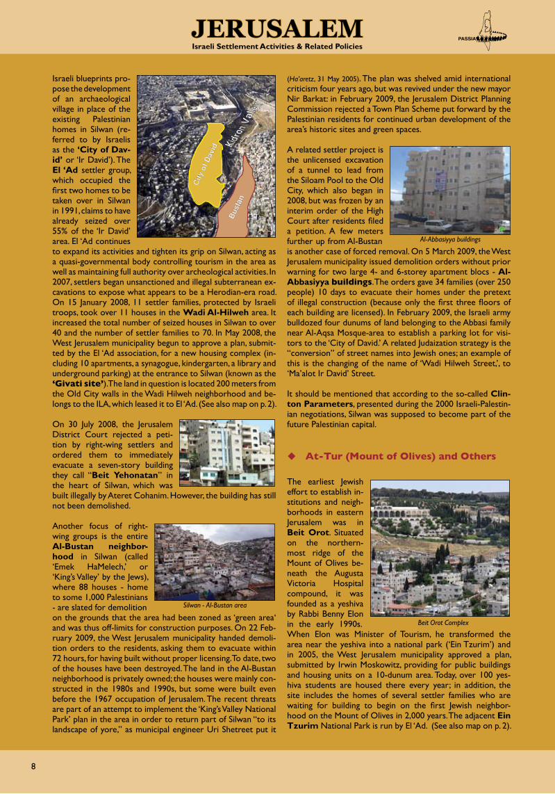
Israeli blueprints pro-pose the development of an archaeological village in place of the existing Palestinian homes in Silwan (re-ferred to by Israelis as the ‘City of Dav-id’ or ‘Ir David’). The El ‘Ad settler group, which occupied the first two homes to be taken over in Silwan in 1991, claims to have already seized over 55% of the ‘Ir David’ area. El ‘Ad continues to expand its activities and tighten its grip on Silwan, acting as a quasi-governmental body controlling tourism in the area as well as maintaining full authority over archeological activities. In 2007, settlers began unsanctioned and illegal subterranean ex-cavations to expose what appears to be a Herodian-era road. On 15 January 2008, 11 settler families, protected by Israeli troops, took over 11 houses in the Wadi Al-Hilweh area. It increased the total number of seized houses in Silwan to over 40 and the number of settler families to 70. In May 2008, the West Jerusalem municipality begun to approve a plan, submit-ted by the El ‘Ad association, for a new housing complex (in-cluding 10 apartments, a synagogue, kindergarten, a library and underground parking) at the entrance to Silwan (known as the ‘Givati site’). The land in question is located 200 meters from the Old City walls in the Wadi Hilweh neighborhood and be-longs to the ILA, which leased it to El ‘Ad. (See also map on p. 2).
On 30 July 2008, the Jerusalem District Court rejected a peti-tion by right-wing settlers and ordered them to immediately evacuate a seven-story building they call “Beit Yehonatan” in the heart of Silwan, which was built illegally by Ateret Cohanim. However, the building has still not been demolished.
Another focus of right-wing groups is the entire Al-Bustan neighbor-hood in Silwan (called ‘Emek HaMelech,’ or ‘King’s Valley’ by the Jews), where 88 houses - home to some 1,000 Palestinians - are slated for demolition on the grounds that the area had been zoned as ‘green area‘ and was thus off-limits for construction purposes. On 22 Feb-ruary 2009, the West Jerusalem municipality handed demoli-tion orders to the residents, asking them to evacuate within 72 hours, for having built without proper licensing. To date, two of the houses have been destroyed. The land in the Al-Bustan neighborhood is privately owned; the houses were mainly con-structed in the 1980s and 1990s, but some were built even before the 1967 occupation of Jerusalem. The recent threats are part of an attempt to implement the ‘King’s Valley National Park’ plan in the area in order to return part of Silwan “to its landscape of yore,” as municipal engineer Uri Shetreet put it
(Ha’aretz, 31 May 2005). The plan was shelved amid international criticism four years ago, but was revived under the new mayor Nir Barkat: in February 2009, the Jerusalem District Planning Commission rejected a Town Plan Scheme put forward by the Palestinian residents for continued urban development of the area’s historic sites and green spaces.
A related settler project is the unlicensed excavation of a tunnel to lead from the Siloam Pool to the Old City, which also began in 2008, but was frozen by an interim order of the High Court after residents filed a petition. A few meters further up from Al-Bustan is another case of forced removal. On 5 March 2009, the West Jerusalem municipality issued demolition orders without prior warning for two large 4- and 6-storey apartment blocs - Al-Abbasiyya buildings. The orders gave 34 families (over 250 people) 10 days to evacuate their homes under the pretext of illegal construction (because only the first three floors of each building are licensed). In February 2009, the Israeli army bulldozed four dunums of land belonging to the Abbasi family near Al-Aqsa Mosque-area to establish a parking lot for visi-tors to the ‘City of David.’ A related Judaization strategy is the “conversion” of street names into Jewish ones; an example of this is the changing of the name of ‘Wadi Hilweh Street,’, to ‘Ma’alot Ir David’ Street.
It should be mentioned that according to the so-called Clin-ton Parameters, presented during the 2000 Israeli-Palestin-ian negotiations, Silwan was supposed to become part of the future Palestinian capital.
u At-tur (Mount of olives) and others
The earliest Jewish effort to establish in-stitutions and neigh-borhoods in eastern Jerusalem was in Beit Orot. Situated on the northern-most ridge of the Mount of Olives be-neath the Augusta Victoria Hospital compound, it was founded as a yeshiva by Rabbi Benny Elon in the early 1990s. When Elon was Minister of Tourism, he transformed the area near the yeshiva into a national park (‘Ein Tzurim’) and in 2005, the West Jerusalem municipality approved a plan, submitted by Irwin Moskowitz, providing for public buildings and housing units on a 10-dunum area. Today, over 100 yes-hiva students are housed there every year; in addition, the site includes the homes of several settler families who are waiting for building to begin on the first Jewish neighbor-hood on the Mount of Olives in 2,000 years. The adjacent Ein Tzurim National Park is run by El ‘Ad. (See also map on p. 2).
Silwan - Al-Bustan area
Al-Abbasiyya buildings
Beit Orot Complex
Bust
an
City
of D
avid

9
JerusalemIsraeli Settlement Activities & Related Policies
In March 2006, settlers succeeded in acquiring property on the far end of the At-Tur neighbor-hood, taking over two four-story buildings (called “Choshen”) not far from the Seven Arches Hotel overlooking the Old City. The circumstances of the takeover, which represented a new effort on the part of set-tlers to create outposts in East Jerusalem, are currently the subject of legal proceedings. The former owners, Abu Al-Hawa and Kiswani families, insisted that they had not sold the build-ings to Jews but to Palestinian buyers (who, in turn, sold the property to a Jordanian investment company), and that signatures on the settlers’ alleged con-tract had been forged. Today, approximately 30 settlers live in the two houses.
Construction is also un-derway to renovate an old house in the Mount of Olives Cemetery, adjacent to two other houses, where about 15 settlers currently live.
Most recently in March 2009, the West Jerusalem municipality handed 29 letters to families living in 10 buildings in the Sahel neighborhood of At-Tur. The letters were either demolition orders or notifications that legal complaints have been filed against them in the Municipal Court for building without a permit. In June 2008, ten homes were destroyed in the same neighborhood and one house in February 2009. Moreover, in January 2009, the municipality placed a sign in the area reading “Entry prohibited. State Lands”, claiming the plot in question has no owner. In the nearby Hardoub area, land was seized for the purpose of the construction of buildings used for “the benefit of the public.”
In addition, several isolated buildings have been occupied by settlers or used as offices, including buildings located in Ath-Thori (Abu Tor) and on Nablus Road (opposite the US Consulate / near the YMCA building). Connecting all these cases shows that the motive behind this policy is to create a Jewish continuum and cut the Old City and its immediate environs off from the Palestinian neighborhoods to the north, thus thwarting any chance of a future agreement based on the division of Jerusalem.
Linked to this is the case of some 400 people in Wadi Yasul (between Ath-Thori and Jabal Mukabber) that have been threatened with the demolition of 55 homes on the pretext that the houses were built in an area zoned as a “green area”. A plan submitted by the residents in 2004 to save their neighbor-hood, was rejected in November 2008 by the District Planning Committee on the grounds that it interferes with the Local Outline Plan for Jerusalem 2000, which keeps it a “green area,” forbidding any development.
the “holy BASIn” AreA Beyond the old cIty
Further evidence that Israeli planning and building laws in East Jerusalem are aimed at reducing Palestinian living space are the infiltration by settlers of the wider “Holy Basin” area - Ras Al-Amud, Jabal Al-Mukabber and Abu Dis (see also map on page 2).
u ras Al-Amud
Ras Al-Amud, home to over 15,000 Palestinians, is located southeast of the Old City on a ridge overlooking Al-Haram Al-Sharif, Silwan, Abu Dis, and Al-Izzariyya.
The Ma’ale HaZeitim (or Ma’ale HaZayit - ‘Olive Heights’) settlement was established on land used by the Al-Ghoul family since 1837. The family, however, did not comply with the 1859 Ottoman rule regarding land registration and it was therefore possible for two Zionist movements (Chabad and Wollin) to register the same plot - about 15 dunums - with the British Mandate authorities in 1928, without even informing the Al-Ghoul family, who continued living on the land. After the War of 1948, the land - then under Jordanian rule - was registered at the Department of ‘Custodian of Enemy Properties,’ which representatives of the Al-Ghoul family sued. The case was held up in the courts until 1962 when the family’s ownership of the land was finally recog-nized and it was officially registered in their name. After the War of 1967 and the subsequent Israeli oc-cupation, Chabad and Wollin - using their registration decree of 1928 - succeeded in having the Israeli Central Court cancel the Jordanian registration and reclaimed the land, which they sold to US Jewish millionaire Irving Moskovitz in 1990 (ARIJ, Ras Al Amoud Neighborhood: A Hot Spot in Occupied East Jerusalem, June 2003). Moskowitz developed a plan for a 132-unit settlement, which was approved by the Jerusalem Municipal Planning Commis-sion, with the agreement of then Mayor Teddy Kollek. Although then Interior Minister Haim Ramon froze the plan because of its sensitive nature, his successor, Ehud Barak, submitted it to the Jerusalem District Zoning Commission, which issued its final approval on 10 December 1996.
Ma’ale HaZeitim was the first major settlement development in the inner circle of East Jerusalem aimed at creating Jewish
Ma’ale Zaytim settlement
nis 47,876 million - This was the amount paid in 2008 to secure the settlers of East Jerusalem! (Peace Now, May 2009).
In addition to governmental support of the private construction being carried out by settler organizations in and around the Old City, the Israeli gov ernment also provides private secu rity services to protect the settlers. Funding for the guards is provided by the Min-istry of Construction and Housing.
“Choshen”
Ras Al-Amud with the Police Station (1) & Ma’ale Zaytim settlement (2)
1
2

10
JerusalemIsraeli Settlement Activities & Related Policies
continuity with the cemetery outside the Old City and the Beit Orot Yeshiva on the Mount of Olives and, thus, to eventually pre-empt any idea of dividing Jerusalem. Construction on 14.5 dunums started in 1998 by the “Kedumim 3000” Co. (which states on its website its “ideological desire to build specifi-cally in Judea and Samaria” and to “employ only Jewish labor”) and the first settlers moved there in April 2003, when world attention was focused on the war in Iraq. Later that year, the initial 132 units were completed and construction continued on facilities such as a commercial center, a synagogue, a kin-dergarten, and a clinic. Today, an estimated 250 settlers live in Ma’ale HaZeitim.
It is worth noting that prior to 1998, the West Jerusalem mu-nicipality had refused to endorse a Master Plan for Ras Al-Amud on the grounds that part of the land belonged to Jews and that it had made its approval conditional on Palestinian residents agreeing to the construction of a Jewish complex in the heart of their neighborhood. The settlement, however, was - despite international protests - eventually forced on the Palestinians, who were only allowed to build on 55-65% of the total land area and no more than two floors per unit (as compared to the settlers who were allowed to build on 115% of the total area with a maximum of seven floors) (ARIJ, The Geopolitical Status of the Jerusalem Governorate, Dec. 2006).
In July 2005, the rightwing ‘Bukharan Community Committee’ and the Israeli Police (through National Police Commissioner Moshe Karadi) signed an ‘exchange deal’ according to which the Committee agreed to build the new police station in the E-1 area and receive in return the current police building, lo-cated in Ras Al-Amud, to use for residential purposes. By doing this they were able to incorporate the building into the adjacent Ma’ale HaZeitim settlement, which is expected to at least double in size. In January 2008, construction begun on another 60 housing units in the settlement, where 51 setter families already lived, and in April 2008, settlers moved into the vacated police building to mark the founding of a new neigh-borhood - ‘Ma’ale David’ - which will eventually comprise of 110 housing units over 10 dunums of land.
u Jabal Mukabber
Jabal Mukabber with an estimated 17,000 inhabitants is a heav-ily populated Palestinian residential area located on a hill south of the Old City and Ath-Thori and adjacent to Sawahreh Al-Gharbiyyeh (West).
The Jabal Mukabber settlement project was initially approved in 1993 but subsequently postponed because of its sensitive nature and questions pertaining to land ownership. In May 2002, the Israeli Digal Investment and Hold-ings Co. - accompa-nied by Israeli forces - fenced off the area, located on a slope below the ‘Goldman Promenade’ north of East Talpiot, and began razing the land and establishing military observation posts. Construction of the ‘Nof Zion’ (formerly ‘Nof Zahav’ or ‘Golden View’) settlement began in 2004
and was approved a year later by the Is-raeli Committee for Planning, after a peti-tion by the Palestin-ian landowners to the Israeli High Court of Justice was rejected. The project - run by private entrepreneurs (Jacques Nasser and Abie Levy) - is slated to cover some 115 dunums, part of which belonged to Jews, and part of which was expropriated from several Arab landowners. It includes the construction of over 400 hous-ing units, a five-star hotel, a synagogue, a Jewish ritual bath, a kindergarten, a school, parks, a shopping center, a country/sports club, and other amenities suited to the needs of pro-spective US buyers. The first of four stages of the construction (91 apartments) was completed in 2008 and the Digal Co. now awaits the final approval from the government to start the second and third stages.
While the El ‘Ad settler group claims that all the land in ques-tion was acquired legally, it is clear that at least half of the land was confiscated by the West Jerusalem municipality from Arab landowners. The landowners subsequently appealed to the Jerusalem District Court on the grounds that the con-fiscation was illegal and that only Arab-owned land had been expropriated and designated as ‘green areas.’ Not surprisingly, however, the court ruled in favor of the West Jerusalem mu-nicipality. The settlement’s infrastructure is to be built on land confiscated from residents of Jabal Mukabber in return for which they were promised better water, electricity, and sew-age services. However, their request to be connected to Nof Zion’s sewage system has been turned down and they remain without a sewage system. It is worth noting that the site is the only space left for future urban development in the area and that while Nof Zion has received permission to build five- and six-storey buildings, construction in Jabal Mukabber is limited to two storeys.
The Jabal Mukabber settlement project is clearly a key link in an evolving chain of settlements being built inside Arab areas to break up Arab continuity and establish Israeli domination over East Jerusalem, thus making it virtually impossible to have a viable Palestinian capital.
u Abu dis
Abu Dis is situated just east of the Jerusalem mu-nicipal border.
Between 1920 and 1930, the Agudat HaDayarim Jewish Cooperative Soci-ety was created in Jerusa-lem in order to establish Jewish neighborhoods for its mem-bers. In 1928, the Agudat purchased 598 dunums of land in the area known today as Abu Dis - due to its proximity to the Old City - in order to build a ‘Garden Community’ (homes with agricultural fields). Despite acquiring the legal title to the area, the increasingly tense relationships between Arabs and Jews during the time of the Arab revolts in Jerusalem resulted in the initiative being abandoned.
Abu Dis
Jabal Mukabber
Nof Zion

11
JerusalemIsraeli Settlement Activities & Related Policies
After the War of 1967, Abu Dis came under the jurisdiction of the General Custodian of the State of Israel. When the Israeli government annexed areas of land to municipal Jerusalem, some 10% of the Abu Dis territory remained inside Jerusalem proper, with the rest being located beyond the Green Line. About 60-70 dunums of that land is owned by the Agudah and designated for a settlement project.
The seizure of Abu Dis land began in June 2000, when a group of right-wing MKs and Jerusalem yeshiva students erected a barbed wire fence and planted olive tree saplings on con-fiscated property in Abu Dis. On 22 May 2000, the Israeli Ministry of Housing endorsed plans for a new settlement in the area to house - initially - some 200 settlers. In early 2004, the West Jerusalem municipality approved the construction of the new ‘Kidmat Zion’ settlement - to con-sist, eventually, of 400 housing units, a kindergarten, a school, and a synagogue on some 64 dunums. On 1 May 2004, four settler families from the Ateret Cohanim movement, equipped with generators and personal items, moved into two homes in the area (‘Bet Ha’Achim’ and ‘Bet Sara’). The land in ques-tion - most of which is said to have been purchased by Jewish American millionaire Irving Moskowitz - is located next to the separation barrier, opposite the unfinished Palestinian parlia-ment building.
However, due to US pressure construction at the site was put on hold. In March 2008, Shas Chairman Eli Yishai demanded that then Prime Minister Olmert immediately unfreeze the construction ban and proceed with the settlement plan. As Jerusalem’s new mayor, one of Nir Barkat’s first acts was to resume the construction of 230 apartments in late 2008. How-ever, on 24 March 2009, the West Jerusalem municipality’s legal adviser, Yossi Havilio, froze the plan in response to a request by Meretz city councilman Pepe Alalo and attorney Danny Seide-man of Ir Amim on the grounds that there had already been illegal construction on the part of the settlers which cannot retroactively be approved. However, it is more than likely that Ateret Cohanim will use all their contacts and strength to push for the revival of the project.
In addition to the settler activities mentioned above, there is also, of course, the Israeli government’s ongoing settlement policy in the wider metropolitan area.
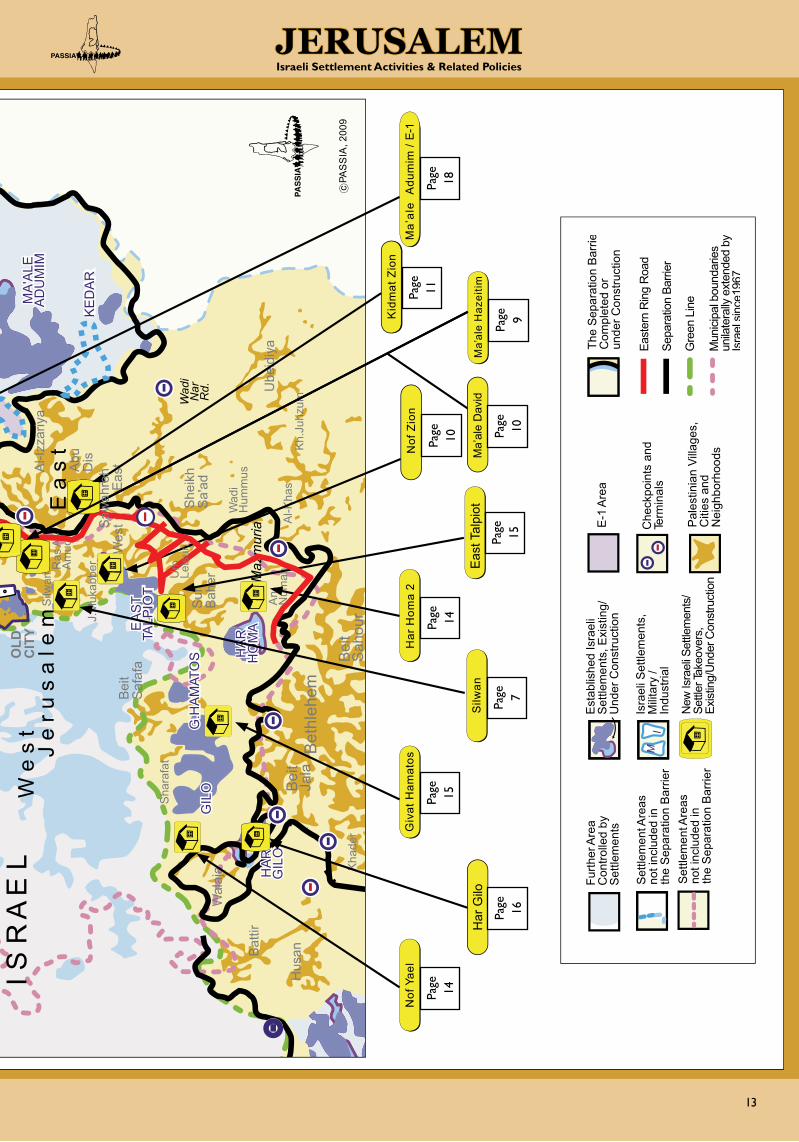
BuIldInG neW And exPAnSIon of SettleMentS WIthIn the MunIcIPAl BoundArIeS
At least 66% of Jerusalem today is territory that was seized by force (5% being former Jordanian Municipality territory, and 61% former West Bank territory). Within this area, Israel has expropriated over 23,380 dunums of mostly Palestinian-owned land, over one-third of East Jerusalem - for the construction of Israeli settlements since 1967 (FMEP, Report on Israeli Settlement, May-June 1999). The settlements form two rings around the city with the inner ring running within the municipal boundaries
and the outer ring (‘Greater Jerusalem’) reaching far into the West Bank. The ‘Greater Jerusalem’ plan is a political rath-er than geographical concept that follows Israel’s vision of a metropolitan Jerusalem stretching from Ramallah (north) to Hebron (south) and from Jericho (east) to Bet Shemesh (west) and covering some 30% of the West Bank. The total area in-volved amounts to 440 km2, of which less than a quarter lies within pre-1967 Israeli borders.
Contrary to Israel’s obligations under international law, the Road Map, and the Annapolis Conference, settlements are also being expanded, constructed or planned at an unprec-edented pace within the municipal boundaries of Jerusalem, where some 190,000 Israeli settlers currently live. This is part of Israel’s overall plan to form a Jewish urban belt around Pal-estinian East Jerusalem and secure Israeli sovereignty over the entire region.
The following is an overview of the projects or plans currently underway in this region (see Map p. 12-13).
u Sha’ar Mizrahi in the Shu’fat-Anata Area
In August 2008, settlers made their first attempts to establish a new outpost (‘Sha’ar Mizrahi’ or ‘Shaare HaMizrah’ – Eastern Gateway) on a hill located between French Hill and Anata, near the Ras Shehadeh neighborhood of Shu’fat Refugee Camp and Bypass Road #1, which links Ma’ale Adumim to Jerusalem. The plan is to establish some 2,000 housing units on the estimated 180 dunums, currently defined as agricultural property, which is the only open space available in the area between Shu’fat Camp, Anata and Al-Issawiyya.
The idea of a settlement at the site is part of the larger Ma’ale Adumin Bloc project and was first raised over nine years ago. In September 2008, Israeli police evicted settlers from the site, but in mid-October Jerusalem mayoral candidate Nir Barkat, who later won the municipal elections and is an outspoken supporter of a greater Jewish presence in East Jerusalem - ex-pressed support for the project. If realized, the plan will pre-vent the territorial contiguity of a future Palestinian state while adding to the establishment of a permanent Jewish presence between Ma’ale Adumim and Jerusalem. In early February 2009, the West Jerusalem municipality gave the green light to Aryeh King to proceed with the Plan. King is an Ateret Cohanim member who represents the alleged Jewish landowner Eliyahu Cohanim, who claims he has held the title deed to the property since 1970, when he bought it from another Jew, who had pur-chased it from an Arab. King has also campaigned hard to have the route of the separation bar-rier in the area changed as the current path will leave the planned Jewish settlement on the “Arab” side of the barrier. A Tel Aviv court is scheduled to hand down its ruling on the matter soon.
Kidmat Zion “settlement”
Site of the planned Sha’ar Mizrahi settlement
Al-Issawiyya
Anata
Shu’fat Camp

12
JerusalemIsraeli Settlement Activities & Related Policies
BE
T H
OR
ON
GIV
'AT
ZE'E
V
GIV
'ON
H
DS
HA
.
HA
R A
DA
R
RA
MO
T
PS
AG
OT
KO
CH
AV
YA'A
CO
V
MA
'ALE
M
IKH
MA
S
MIG
RO
N
HA
R
SH
MU
EL
R.S
HLO
MO
P.ZE
'EV
N.Y
A'A
CO
V
ALM
ON
E-1
GE
VA
BIN
YAM
IN
KFA
R
AD
UM
IM
MA
'ALE
A
DU
MIM
KE
DA
R
FR.H
ILL
ALO
N
R.E
SH
KO
L
EA
ST
TALP
IOT
HA
R
HA
R
HO
MA
GIL
O
G.H
AM
ATO
S
HA
R
GIL
O
M
M
MIS
HO
R
AD
UM
IM
SH
A'A
R
BIN
YAM
IN A
NAT
OT
ME
TZ.
AD
UM
IM
ATA
RO
T
RA
MA
OFE
R
Mev
asse
ret
Zion
I S R
A E
L
Ana
ta
Hiz
ma
Ar-
Ram
Ja
ba
Mik
hmas
Za'im
New
Pol
ice
Sta
tion
Al-I
zzar
iya
Abu
D
is
She
ikh
Sa'
ad
Sur
B
aher
Bei
t S
afaf
a
Sha
rafa
t
Ube
idiy
a A
n-
Num
an
Al-K
has
Hus
an
Bat
tir
Wal
aja
Bet
hleh
em
Bei
t Ja
la
Bei
t S
ahou
r
Silw
an R
as A
l- A
mud
'Isaw
iya
Shu
'fat
Bei
t H
anin
a
Bei
t Ik
sa
Bei
t S
urik
Bid
du
Qub
eiba
Qat
anna
Bei
t In
an
Bei
t D
uqqu
B
eit
Ijza
Nab
i S
amw
il
Al-
Jib
Bir
Nab
ala
Ram
alla
h A
l- B
ireh
Bur
qa
Dei
r D
ibw
an
Bei
tuni
a B
eit U
r Fo
qa
Tira
R
afat
Qal
andi
ya
Qal
andi
a R
C
Kuf
r A
qab
Ein
A
rik
RC
OLD
C
ITY
Wad
i H
umm
us
Kh.
Juhz
um
Kha
der
J e
r u
s a
l e m
W
e s
t E
a s
t
Wes
t E
ast
Wad
i N
ar
Rd.
J.M
ukab
ber
Sh.
Ja
rrah
Jude
ira
BH
B
alad
Al-A
mar
i RC
Al-J
ib
Wes
t
Wad
i Joz
Bei
tuni
a
Ada
m
Ana
tot
Maz
mur
ia
Shu
’fat
RC
HO
MA
The
Sep
arat
ion
Bar
ri eC
ompl
eted
or
unde
r Con
stru
ctio
n
East
ern
Rin
g R
oad
Sepa
ratio
n Ba
rrier
Gre
en L
ine
Mun
icip
al b
ound
arie
s un
ilate
rally
ext
ende
d b y
Isra
elsi
nce1
967
P
ales
tinia
n Vi
llage
s,
Citi
es a
nd
Nei
ghbo
rhoo
ds
E
-1 A
rea
Furth
er A
rea
C
ontro
lled
by
Set
tlem
ents
S
ettle
men
t Are
as
not i
nclu
ded
in
the
Sep
arat
ion
Bar
rier
Set
tlem
ent A
reas
no
t inc
lude
d in
th
e S
epar
atio
n B
arrie
r
New
Isra
eli S
ettle
men
ts/
Settl
er Ta
keov
ers,
Ex
istin
g/U
nder
Con
stru
ctio
n E
stab
lishe
d Is
rael
i S
ettle
men
ts, E
xist
ing/
U
nder
Con
stru
ctio
n Is
rael
i Set
tlem
ents
, M
ilita
ry /
Indu
stria
l
M
I C
heck
poin
ts a
nd
Term
inal
s
Kid
mat
Zio
n
Aga
n H
a’A
galo
t
Har
Hom
a 2
Ma’
ale
Haz
eitim
Nof
Yae
l
Gev
a / A
dam
Shim
on H
aTza
dik
She
perd
s H
otel
Qal
andi
a / A
taro
t
Ma’
ale
Adu
mim
/ E-
1G
ivat
Ham
atos
Silw
an
Bur
j Al-
Laql
aq
c PA
SS
IA, 2
009
At-T
ur
Nof
Zio
n
Har
Gilo
Sha
’ar M
izra
hi
Eas
t Tal
piot
Ma’
ale
Dav
id
At-T
ur (C
hosh
en)
Saw
ahre
h
Um
Le
isun
Page
4
Page
11
Page
9
Page
17
Page
6
Page
5
Page
16
Pa
ge
16
Isra
eli S
ettl
emen
t C
onst
ruct
ion
and
Pla
ns in
and
aro
und
Eas
t Je
rusa
lem
13
JerusalemIsraeli Settlement Activities & Related Policies
BE
T H
OR
ON
GIV
'AT
ZE'E
V
GIV
'ON
H
DS
HA
.
HA
R A
DA
R
RA
MO
T
PS
AG
OT
KO
CH
AV
YA'A
CO
V
MA
'ALE
M
IKH
MA
S
MIG
RO
N
HA
R
SH
MU
EL
R.S
HLO
MO
P.ZE
'EV
N.Y
A'A
CO
V
ALM
ON
E-1
GE
VA
BIN
YAM
IN
KFA
R
AD
UM
IM
MA
'ALE
A
DU
MIM
KE
DA
R
FR.H
ILL
ALO
N
R.E
SH
KO
L
EA
ST
TALP
IOT
HA
R
HA
R
HO
MA
GIL
O
G.H
AM
ATO
S
HA
R
GIL
O
M
M
MIS
HO
R
AD
UM
IM
SH
A'A
R
BIN
YAM
IN A
NAT
OT
ME
TZ.
AD
UM
IM
ATA
RO
T
RA
MA
OFE
R
Mev
asse
ret
Zion
I S R
A E
L
Ana
ta
Hiz
ma
Ar-
Ram
Ja
ba
Mik
hmas
Za'im
New
Pol
ice
Sta
tion
Al-I
zzar
iya
Abu
D
is
She
ikh
Sa'
ad
Sur
B
aher
Bei
t S
afaf
a
Sha
rafa
t
Ube
idiy
a A
n-
Num
an
Al-K
has
Hus
an
Bat
tir
Wal
aja
Bet
hleh
em
Bei
t Ja
la
Bei
t S
ahou
r
Silw
an R
as A
l- A
mud
'Isaw
iya
Shu
'fat
Bei
t H
anin
a
Bei
t Ik
sa
Bei
t S
urik
Bid
du
Qub
eiba
Qat
anna
Bei
t In
an
Bei
t D
uqqu
B
eit
Ijza
Nab
i S
amw
il
Al-
Jib
Bir
Nab
ala
Ram
alla
h A
l- B
ireh
Bur
qa
Dei
r D
ibw
an
Bei
tuni
a B
eit U
r Fo
qa
Tira
R
afat
Qal
andi
ya
Qal
andi
a R
C
Kuf
r A
qab
Ein
A
rik
RC
OLD
C
ITY
Wad
i H
umm
us
Kh.
Juhz
um
Kha
der
J e
r u
s a
l e m
W
e s
t E
a s
t
Wes
t E
ast
Wad
i N
ar
Rd.
J.M
ukab
ber
Sh.
Ja
rrah
Jude
ira
BH
B
alad
Al-A
mar
i RC
Al-J
ib
Wes
t
Wad
i Joz
Bei
tuni
a
Ada
m
Ana
tot
Maz
mur
ia
Shu
’fat
RC
HO
MA
The
Sep
arat
ion
Bar
ri eC
ompl
eted
or
unde
r Con
stru
ctio
n
East
ern
Rin
g R
oad
Sepa
ratio
n Ba
rrier
Gre
en L
ine
Mun
icip
al b
ound
arie
s un
ilate
rally
ext
ende
d b y
Isra
elsi
nce1
967
P
ales
tinia
n Vi
llage
s,
Citi
es a
nd
Nei
ghbo
rhoo
ds
E
-1 A
rea
Furth
er A
rea
C
ontro
lled
by
Set
tlem
ents
S
ettle
men
t Are
as
not i
nclu
ded
in
the
Sep
arat
ion
Bar
rier
Set
tlem
ent A
reas
no
t inc
lude
d in
th
e S
epar
atio
n B
arrie
r
New
Isra
eli S
ettle
men
ts/
Settl
er Ta
keov
ers,
Ex
istin
g/U
nder
Con
stru
ctio
n E
stab
lishe
d Is
rael
i S
ettle
men
ts, E
xist
ing/
U
nder
Con
stru
ctio
n Is
rael
i Set
tlem
ents
, M
ilita
ry /
Indu
stria
l
M
I C
heck
poin
ts a
nd
Term
inal
s
Kid
mat
Zio
n
Aga
n H
a’A
galo
t
Har
Hom
a 2
Ma’
ale
Haz
eitim
Nof
Yae
l
Gev
a / A
dam
Shim
on H
aTza
dik
She
perd
s H
otel
Qal
andi
a / A
taro
t
Ma’
ale
Adu
mim
/ E-
1G
ivat
Ham
atos
Silw
an
Bur
j Al-
Laql
aq
c PA
SS
IA, 2
009
At-T
ur
Nof
Zio
n
Har
Gilo
Sha
’ar M
izra
hi
Eas
t Tal
piot
Ma’
ale
Dav
id
At-T
ur (C
hosh
en)
Saw
ahre
h
Um
Le
isun
Page
16
Page
14
Page
15
Page
7
Page
14
Page
15
Page
10
Page
11
Page
9
Page
10
Page
18

14
JerusalemIsraeli Settlement Activities & Related Policies
u nof yael near Walajeh
The village of Walajeh, which is located in southern Jeru-salem close to Bethlehem (both inside and beyond the West Jerusalem municipality border), has traditionally been associ-ated with the cultivation of vineyards, olive trees, wheat, barley, and fruits. After the Naqba and the War of 1948, the village was handed to Israel in accordance with the terms of the Ar-mistice Agreement signed with Jordan on 3 April 1949, which stipulated that the southern Jerusalem boundary line would run along the Jerusalem-Jaffa railway line, north of which Wala-jeh was situated (now the site of Jerusalem’s Biblical Zoo). The villagers left their homes and moved south of the tracks into Jordanian territory, where much of their land was located. Since they enjoyed UNRWA refugee status, many also moved into the Dheisheh or Shu’fat refugee camps.
After the War of 1967, the boundaries of the expanded East Jerusalem, which Israel had annexed illegally, brought nearly the entire area of the new vil-lage within Jerusalem’s city limits (the remainder becoming part of Israel proper, located on the other side of the Green Line.) However, although the land was annexed, its residents were not absorbed and they were consequently not included in the subsequent Israeli 1967 census. As a result of this, they received West Bank identity cards instead of Jerusalem resi-dency cards to which they were legally entitled.
Today, the approximately 2,000 residents of Walajeh, although living in Jerusalem, depend on the Palestinian Authority for all their services as the Israeli Ministry of Interior still refuses to issue them with Jerusalem ID cards (permanent residency). Their village, meanwhile, is surrounded on all sides by Jewish settlements (Har Gilo and Betar Illit).
The new ‘Nof Yael’ (sometimes also ‘Givat Yael’) set-tlement project was launched in June 2004 with the aim to provide 13,600 housing units for up to 60,000 set-tlers on 4,110 dunums and to link Jerusalem and the Etz-ion settlement bloc. Half the land in question is within city limits, and half is on the other side of the Green Line. The Ministry of Interior claims that the land on which the settlement is situated was purchased by the Jewish National Fund subsidiary Himnuta, which confirmed ownership but de-nied any connection to the settlement project. There are also claims that the plan is a completely private initiative (based on land sales made possible by the use of forged documents). However, the Israeli campaign of house demolitions in the area suggests that the Nof Yael plan is/was both sponsored and ap-proved by the State.
At about the same time as the new settlement project was launched, the Walajeh checkpoint was established (it was later, on 19 Feb. 2006, transformed into a border passage by an Israeli military order according to which some 40 dunums of Walajeh land was confiscated to allow for the construc-tion of a new terminal). In addition, the revised route of the separation barrier, approved by the Israeli Cabinet on 30
April 2006, included the encirclement of Walajeh, leaving it completely fenced in and with only one access road, passing through the Israeli controlled Har Gilo terminal.
On 17 February 2009, the Jerusalem District Planning Board re-jected a town plan (along with one for the Bustan/Silwan area) that would have legalized hundreds of illegally-built homes, in part due to its unwillingness to legitimize, en mass, “illegal” construction.
u har homa on Jabal Abu Ghneim
Jabal Abu Ghneim was a tree-covered hill located within the southern municipal boundaries of Jerusalem that was privately owned by Palestinian families from Beit Sahour, Bethlehem, Sur Baher, and Umm Tuba. In 1968, the West Jerusalem municipal-ity classified it as a “green area” – restricting development in order to preserve its ecological diversity. However, Israel con-
fiscated the mountain in 1991 to build a new settlement. After the Israeli government’s February 1997 announcement that 6,500 Jewish homes for some 30,000-40,000 Israelis would be constructed at the site and the beginning of construction work the following month, Palestinian protests led to a breakdown in the peace talks. Due to heavy international pressure, con-struction was eventually frozen. A few months later, the Israeli government tried to calm things down by offering to build 3,000 new apartments and 400 government-financed housing units in the nearby Arab neighborhood of Sur Baher. In No-vember 1998, Israel began leveling the hill and advertising for tenders, and construction of apartments began in August 1999. In November 2000, the West Jerusalem municipality started planning for an additional 4,000 units (‘Har Homa B’) and in January 2002, the first settlers moved into the settlement.
In January 2007, Israel’s Ministry of Housing and Construc-tion approved the first 983 units for a new settlement (‘Har Homa C’) west of Har Homa and south of the Mar Elias Mon-astery. In addition, a new residential area (‘Khirbet Mazmu-ria’ - ‘Har Homa D’) is planned southeast of Har Homa, the plan being to extend Har Homa up to the municipal border. However, it is doubtful whether the plan will actually materi-
Walajeh Land
Jabal Abu Ghneim prior to the construction of Har Homa
Ongoing construction at Har Homa

15
JerusalemIsraeli Settlement Activities & Related Policies
alize following the decision made by Attorney General Menachem Mazuz in February 2005 that it is forbidden to apply the Absen-tee Owners Prop-erty Law within the boundaries of Jerusalem. The West Jerusalem municipality’s Master Plan ‘Jerusalem 2000’ finally points to the expansion of Har Homa by 28% (some 1,410 dunums) so that it will eventu-ally spread over some 2,500 dunums of land (ARIJ, The Geopolitical Status of the Jerusalem Governorate, Dec. 2006).
Shortly after the Annapolis Conference, on 4 December 2007, Israel issued tenders for the construction of 307 new homes in Har Homa, and at the end of that month Peace Now revealed that Israel’s 2008 budget included NIS 50 million for the con-struction of 500 new homes in the settlement. Israeli Housing Minister Ze’ev Boim demanded in February 2008 approval for the construction of another 360 housing units in Har Homa and in early June 2008 he announced tenders for 121 housing units. On 9 July 2008 the Har Homa C plan to build 910 new homes to the south and east of the current construction line was submitted for public review. A related issue of concern is that - in direct contradiction to the Attorney General’s order - large parts of the lands slated for further construction in Har Homa belong to Palestinians from the Bethlehem-Beit Sahour area who were declared “absentees” after the 1967 War.
As of 2008, Har Homa housed some 4,000 families as well as kindergartens, day care centers, schools, clinics, and shop-ping centers. According to a report by the Negotiations Affairs Department (Dec. 2008), Town Planning Schemes for 2,653 housing units in Har Homa have been approved in the pe-riod between the Annapolis Conference and November 2008 alone. And in February 2009, the municipality approved 14 new housing units and a public structure (Ha’aretz, 12 Feb. 2009).
u other developments in brief:
Ramot:On 28 January 2008, a Town Plan-ning Scheme was released for public review, indicating construction plans for some 1,300 residential units, 105 of which be-yond the Green Line. The aim of this plan is to fill the “gap” between Ramot and Beit Iksa village. According to a report by the Negotiations Affairs Department (Dec. 2008), Town Planning Schemes for 338 units have been approved in the period between the Annapolis Conference and November 2008, while 1,600 units were awaiting final approval. Added to this on 12 December 2008, Yediot Aharonot reported on plans by the Housing Ministry and the Israel Land Administration to issue 745 tenders in 2009 for Ramot.
Ramat Shlomo (also known as Rekhes Shu’fat):The West Jerusalem munici-pality’s Regional Committee for Housing and Planning agreed on 13 June 2008 to construct 1,300 new hous-ing units, all on a plot origi-nally designated as “green area” to preserve its ecological di-versity.
Pisgat Ze’ev:In April 2008, the Israeli government announced plans for at least 600 new apartments and, accord-ing to a December 2008 report by the Negotia-tions Affairs Department, Town Planning Schemes for 759 units have been approved in the period between the Annapolis Conference and November 2008.
East Talpiot:According to a report by the Negotiations Affairs Department (Dec. 2008), 620 units have been ap-proved between the An-napolis Conference and November 2008, while 104 units were awaiting final approval. In Febru-ary 2009, Israel began construction - initially approved in 2000 - on over 60 new housing units in three 7-8 storey buildings for Orthodox Jews. The project is marketed as part of the development of East Talpiot, but the 3.5-dunum building site is surrounded on three sides by the Palestinian neighborhood of As-Sawahreh. It should be noted that in contrast, construc-tion for As-Sawahreh residents is restricted to three apart-ment structures and two floors per dunum.
Givat Hamatos: In February 2008, the West Jerusa-lem municipality’s city manager Yair Ma’ayan revealed c o n s t r u c t i o n plans for Givat Hamatos, a cara-van village hous-ing Ethiopian Jews since 1991. The is-sue of ownership is complex involving Israeli, Palestinian, and church property and it seems unlikely that the plans will be implemented soon. However, building plans for a total of 3,150 of the total of 4,000 units were submitted for public review in March and May 2008. In July 2008, construction of 2,500 housing units was approved. The proposed neighborhood, drawn up by the Israel Land Ad-ministration, envisages high-rise buildings and a bypass road connecting to nearby Gilo and Har Homa settlements and will effectively cut Beit Safafa off from other Palestinian areas.
Har Homa advertisement
Pisgat Ze’ev settlement
Ramot settlement
Construction in As-Sawahreh
Caravans at Givat Hamatos
Ramat Shlomo settlement

16
JerusalemIsraeli Settlement Activities & Related Policies
Har Gilo:In August 2004, the Israel Land Admin-istration approved building plans for Har Gilo (estab-lished in 1972 on lands belonging to Beit Jala and Al-Walaja) that includ-ed 200 housing units as part of phase one of an overall plan to build 1,084 new duplex apartments. Con-struction on 286 (not 200!) housing units, began in April 2005, and was completed in 2008. Phase two - with a further 480 du-plex units - is now underway and is expected to be completed by 2012. Likewise plans for a third phase - another 318 duplex apartments are expected soon. Moreover, due to the route of the separation barrier, which is being constructed nearby, ad-ditional land will become part of the settlement area.
Gilo: In late 2007, Israel published tenders for an unspecific number of new c o n s t r u c t i o n projects, affecting the Palestinian neighborhoods of Beit Safafa and Sharafat; in addi-tion to this, there are a number of private sec-tor development projects underway in Gilo. On 16 March 2008, tenders for 75 housing units were granted, and by the end of 2008, another 150 units were awaiting submission for public review and a fur-ther 850 units were in the planning phase. In early March 2009, the Israeli government announced plans for a huge 2,570-unit housing project in Gilo, with 860 units to be constructed in the first stage.
the SettleMent enterPrISe Beyond the MunIcIPAl BoundArIeS (‘GreAter JeruSAleM’)
Besides expanding settlements located within the municipal boundaries (with some 190,000 settlers), Israel also contin-ues to pursues the ‘Greater Jerusalem’ plan (with an additional 96,000 settlers). The plan is a political concept that follows the vision of a metropolitan Jerusalem covering some 30% of the West Bank from Ramallah (north) to Hebron (south) and from Jericho (east) to Bet Shemesh (west). The total area involved amounts to 440 km2, of which less than a quarter lies within pre-1967 Israeli borders. Peace Now analyses have shown that there are construction plans that will double the size of settle-ments in this area, including Givat Ze’ev/Agan Ha’Ayalot, Atar-ot/Qalandia, Geva Binyamin (Adam), and Ma’ale Adumim/E-1.
u Givat Ze’ev - Agan ha’Ayalot
In 1999, the Agan Ha’Ayalot (‘Gazelle Basin’) neighborhood west of Givat Ze’ev was first approved and the Israel Land Administration began selling plots for 546 housing units. Some of the 11 contractors who won tenders started construction work, but interest was low because the site was too far from Givat Ze’ev, lacked infrastructure, and was accessible only via Route 443, which, apart from being vulnerable to attacks, also led to Modi’in, that was at the time competing for potential buyers. Coupled with this was US pressure to halt the con-struction and the project was frozen in 2000. Despite this, in 2003 when Palestinians of nearby Beit Surik filed a petition, the State justified planning the route of the separation barrier through the area by refer-ring to the need to protect a new settlement - Agan Ha’Ayalot. In March 2008, three months after the Annapolis summit, the Israeli Housing Ministry announced plans for some 2,000 new housing units in settlements, including 750 in Agan Ha’Ayalot, where construction started a month later.
The new neighbor-hood - some three kilometers from Givat Ze’ev - will effectively become a new satellite set-tlement that will expand the western border of the over-all settlement bloc.
u Atarot / Qalandia Airport
On 27 February 2007, Ha’aretz published a report concerning new Israeli plans to build an Ultra Orthodox settlement with 11,000 units near Qalandia Airport and the Atarot Indus-trial Zone. The report also revealed plans to connect that area via a tunnel - passing beneath Kufr Aqab and the separa-tion barrier - with the Kokhav Ya’akov settlement east of Ramallah. In December 2007, Israel’s Housing Minister Ze’ev Boim announced that his ministry “was looking into building a new Jewish neighborhood with 10,000 apartments in Atarot.” However, largely due to US pressure - the plan was put “under study”. It was not the first time that the area made headlines as a potential site for a new settlement scheme and it is likely that efforts to implement the plan will reemerge. If approved, it would eventually ensure Israel’s complete hold on Jerusalem. At the moment, the separation barrier carves out the Atarot industrial zone as part of Israeli Jerusalem, and keeps Qalandia refugee camp and the areas around it, including the Jerusalem neighborhoods of Kufr Aqab and Semiramis, within the Pales-tinian (West Bank) area. The “Jerusalem 2000” Master Plan rec-ommends Atarot become the main area for traditional indus-tries in East Jerusalem, and calls for the transfer of garages, car repair and body shop businesses from the Wadi Joz to Atarot.
Har Gilo settlement expansion
Gilo settlement (with the tunnel road in the foreground)
Givat Ze’ev settlement
Agan Ha’Ayalot site

17
JerusalemIsraeli Settlement Activities & Related Policies
u neve ya’akov and Geva
The Geva Binyamin settlement (also referred to as Adam) was established in 1984, some 2 km north of the municipal boundary of Jerusalem, 6.5 km from the Green Line. It is situ-ated outside (east of) the separation barrier, but a substantial part of its jurisdictional area to the west of the built-up area is included on the ‘Israeli’ side of the barrier. It forms a con-tiguous bloc with the Neve Ya’acov settlement, which lies within the municipal boundaries in East Jerusalem. Expanding the settlement with 1,500 housing units (‘Plan No. 240/3‘) is thus in effect an expansion of Neve Ya’akov, to which the new neighborhood will be attached, the aim being to connect Geva
Binyamin to the east and in effect expanding Jerusalem’s bor-ders further into the West Bank. Most of the land covered by the plan has been declared State land - at the expense of land belonging to the Palestinian village of Hizma. The project was first revealed in March 2007 and one year later, the West Je-rusalem municipality announced plans to build 400 new hous-ing units in Neve Ya’akov and according to a report by the Negotiations Affairs Department (Dec. 2008), 393 units were submitted for public review since the Annapolis conference and were awaiting final approval. In February 2009, Defense Minister Ehud Barak approved the establishment of a new
Airport
Atarot
Qalandia
Kufr Aqab
Kokhav Ya’akov
Qalandia Camp
Jaba’
Plan 240/3
Geva Binyamin
(Adam)
Al-Ram
Jaba’
Hizma
Neve Ya’akov
Plan 240/2/14
The Separation Barrier

18
JerusalemIsraeli Settlement Activities & Related Policies
(initially) 250-house settlement next to Adam in exchange for the evacuation of the illegal Migron outpost near Ramallah whose 45 families would relocate to the as-yet un-built neigh-borhood. The project’s first stage will include 50 houses but before construction takes place a plan (‘Plan No. 240/2/14’) for 1,380 housing units must be drawn up and approved.
u Ma’ale Adumim and the e-1 (east 1) Plan
To the northeast of Jerusalem, Israel’s separation barrier was constructed some 15 km into the West Bank in order to in-clude the entire Adumim settlement bloc, where Israel is pur-suing plans to almost triple the current size of Ma’ale Adumim (now with over 33,000 settlers) by developing the area to its east and connect it to Jerusalem. While Ma’ale Adumim’s current built-up area is some 7 km2, its municipal plan cov-ers a total area of 55 km2, stretching almost to the Dead Sea and including, to the north, the contested 12 km2-E-1 area (P. Rekacewicz/D. Vidal, “Jerusalem: Whose very own and golden city?” Monde Diplomatic, Feb. 2007).
If implemented, the E-1 Plan - dubbed Mevasseret Adumim (see box) - will cut the West Bank into two, make it practically impossible to establish a Palestinian state with territorial con-tiguity. The plan will make it impossible to reach agreement on the question of permanent borders, and will grab the last area of open land available for Palestinian development.
While the E-1 Plan was - for the time being - removed from the agenda for political rea-sons, construction of the new ‘Judea and Samaria District Police’ HQ in the E-1 area, commenced in March 2006 (see section on Ras Al-Amud above), was meanwhile com-pleted and is widely seen as a strategic step in claiming the area for further Jewish develop-ment. Unless there is a clear “hands-off” message from Wash-ington, Israel is likely to push ahead with its plans unabated.
A new Peace Now report reveals that the Israeli Housing Ministry has approved detailed plans for 1,708 units in Ma’ale Adumim and has prepared plans for another 5,700 units. In addition, its master plan foresees the addition of 6,000 housing units in order to expand the settlement for 104,000 settlers. (Peace Now, Ministry of Housing Plan’s for the West Bank, March 2009)
In a related develop-ment, Israeli Interior Minister Eli Yishai approved on 3 May 2009 recommenda-tions by a special ministerial com-mittee to expand Ma’ale Adumim by 12,000 dunums and added 6,000 housing units to the south of the settlement. In so doing, the nearby Kedar settlement, which houses 800 set-tlers at present, will be linked to Ma’ale Adumim and eventually incorporated into its municipality. The implementation of this plan will also affect the route of the separation barrier with a
single wall encircling both settlements (as opposed to the cur-rent recommendation for two separated walls).
Ongoing construction at Ma’ale Adumim
e-1 PlAn – MevAsseret AduMiMThe E-1 plan, which has yet to be implemented, in volves the building of a large new Israeli neighborhood in the narrow un-developed land corridor that runs east of Jerusalem and is part of the West Bank (see map pages 12-13). The plan involves about 12,000 dunums (12 km2) of land, a significant part of which is privately owned Palestinian land. Most of the area was declared ‘State land’ by Israel in the 1980s (i.e., land that is not owned by any individual and is thus the property of the State).
In 1994, Yitzhak Rabin expanded the borders of Ma’ale Ad-umim to include the E-1 area but refrained from im plementing any construction in accordance with an understanding with the US Administration that the fate of the area would be determined within the framework of the peace process. The Netanyahu gov-ernment (1996-99) attempted to expedite the E-1 Plan but it was not formally approved. Prime Minister Barak, who sup ported the plan, subsequently placed it on the negotiat ing table at Taba in early 2001 but refrained from al lowing any construction in the area to begin.
In 2002, then Defence Minister Ben Eliezer signed the E-1 Master Plan into law, but, primarily because of US objections, nothing else happened until mid-2004, when the Sha ron Admin-istration commenced infrastructural work (clearing roads). This action was illegal since no specific town plan existed and thus no permits could be or were issued. In April 2005, the Israeli au-thorities advertised the plan, which includes 3,500 housing units for up to 20,000 settlers, hotels, an indus trial park, and commer-cial and entertainment buildings.
More recently, Ha’aretz reported that over the past two years, Is-rael has invested almost NIS 200 million in infrastructure for construction in the E-1 area (Ha’aretz, “Israel plans to build up West Bank corridor on contested land”, 1 Feb. 2009). In March 2009, Peace Now re-vealed government plans to double Ma’ale Adumim in size, and on 25 March, Israeli Army Radio reported that Prime Minister-designate Neta nyahu had struck a se cret deal with Yisrael Beit-einu leader Avigdor Lieber man to build 3,000 new housing units in the E-1 area.
New ‘Judea and Samaria District Police’ in the yet undeveloped E-1 area
Location of the E-1 area
Az-Za’im
Al-Izzariyya
E-1
Ma’ale Adumim

19
JerusalemIsraeli Settlement Activities & Related Policies
other relAted PolIcIeS And PlAnS
u Master Plan Jerusalem 2000
On 13 September 2004, then-Mayor of Jerusalem, Uri Lupo-lianski disclosed the ‘United Jerusalem’ Town Planning Scheme, known as Master Plan 2000, to serve as a mandatory map for land use and a blueprint for other municipal planning pur-poses. The plan included the addition of 65,000 housing units to existing settlements until the year 2020. The ‘stated’ target of the plan is a city population made up of 70% Jews and 30% Palestinians. Attempts at geographic and demographic manipu-lation to counter the current trend, which suggests a popula-tion ratio of 60:40 by 2020, include: (1) the construction of the separation barrier, which excludes tens of thousands of Palestinians from living within the municipal borders; (2) the closure regime; (3) house demolition policies; (4) a proposed transportation system that ignores the legitimate planning in-terests of the Palestinian residents, and (5) the expropriation of private Palestinian land and property (through attempts to apply the 1950 Absentee Property Law). The Master Plan pro-vides for the establishment of more Jewish settlements (for instance, two additional settlements near Har Homa) and nu-merous other Jewish public institutions. This will involve the further confiscation of Palestinian land, hampering Palestinian development, ignoring Palestinian housing demands, and fur-ther fragmenting and isolating Palestinian suburbs from each other as well as from the West Bank. The plan further fails to propose any new industrial, commercial, service or develop-ment areas in East Jerusalem while, at the same time proposing to eradicate the Wadi Al-Joz Industrial Area and designating a large track of land between Jabal Al-Mukabber and Ath-Thori as “a nature reserve” (thus precluding future development of these areas).
u the road network
Israel is currently building the Jerusalem Ring Road on the outskirts of the city, which is intended to reinforce Israeli set-tlements and connect them with West Jerusalem. It will also join the Givon and Binyamin settlement blocs to the north of Jerusalem, as well as encircle East Jerusalem in order to consol-idate Israeli control over the occupied Palestinian parts of the city. The Ring Road is comprised of two main sections, an east-ern road and western road, along with three extensions, the Train Road in the south, Road #9 in the center, and Road #20 in the north which splits the center of Beit Hanina. With the
exception of an 11.5-km-long part of the Eastern Ring Road (see overview map p. 12-13), which requires the construction of three tunnels and five bridges as it goes through several densely populated Palestinian neighborhoods (Az-Zaim, At-Tur, Ras Al-Amud, Al-Izzariyya, Abu Dis, Sawahreh Al-Gharbiya, Al-Qun-bar, and Sheikh Sa’ad to Sur Baher), most of the Ring Road is now completed. The completion of the project involves confiscation of over 1,237 dunums of privately owned Palestinian land and the demolition of several Palestinian houses. (PLO Negotiations Affairs Department, Carving Up the Palestinian Capital: The Israeli Ring Road Around Occupied East Jerusalem, February 2008).
In addition, work is underway on a road east of Jerusalem to have Palestinian transport between the northern and south-ern West Bank “bypass” East Jerusalem, through a system of tunnels and streets. It is very likely that Israel will use the argument of an existing Palestinian “contiguity route” to sup-port its claim that the implementation of the E-1 Plan would not interfere with Palestinian life. Interestingly, a parallel Israeli-only road intends to connect Ma’ale Adumim to Jerusalem. Palestinian traffic will further be diverted from the E-1 area by another bypass road south of the Adumim bloc.
u the Separation Barrier, checkpoints and terminals
On 30 April 2006, the Is-raeli Cabinet approved a revised route of the separation barrier in the Jerusalem area, including the relocation of Beit Iksa and its lands from the Jerusalem side of the barrier to the Biddu/Beit Surik group of West Bank villages and the encircle-ment of Walajeh, thus isolating the village from its farmland. While Israel claims the barrier provides security to its residents, in actuality it is being created to redefine Jerusalem’s borders and its demographic makeup by maximizing the number of Pal-estinian Jerusalemites living behind the wall while maximizing the amount of Palestinian land on the ‘Israeli’ side. Accordingly, the barrier deviates from the Green Line to incorporate Jew-ish settlements while removing Arab neighborhoods with an estimated combined population of at least 60,000 (Kufr Aqab, Qalandia camp, half of Beit Hanina, most of Ar-Ram, Dahiet Al-Barid, Hizma, Shu’fat Refugee Camp, Da-hiet As-Salam, Anata, Ras Khamis, and Walajeh).
Construction of the Ring Road
Separation barrier at Abu Dis
Separation barrier at Ras Khamis/Shu’fat
sAfdie PlAn – shelved but …The plan, named after architect Moshe Safdie, was initiated by the ILA and the Jerusalem Development Authority during Ehud Olmert’s tenure as West Jerusalem Mayor. It called for the construction of some 20,000 housing units on hills stretching over 24,200 dunums to the west of Jerusalem as well as the building of additional roads to serve the new neighborhoods. Despite harsh opposition by environmentalists, and a report by an independent investigator (Tomer Guthalf), that found some 45,500 housing units could be built on existing land reserves in Jerusalem to meet the city’s housing demands until 2020, the National Planning and Building Board decided on 6 February 2007 to cancel the plan. This had major consequences for the Palestinians since Jewish expansion is now focused on their land, the construction at Har Homa is an example of this.

20
JerusalemIsraeli Settlement Activities & Related Policies
The length of the planned separation barrier is 790 km, of which an estimated 167.3 km will be built in and around Jerusa-lem (referred to as the ‘Jerusalem Envelope’). By mid-2008, it was estimated that some 50% of the construction was com-pleted (Ir Amim, Progress of the Separation Barrier in Jerusalem: July 2008). The barrier in the Jerusalem area now de facto annexes 228.2 km
2 or 3.9% of the West Bank. It will separate or isolate over
230,000 Palestinian Jerusalemites from the rest of the West Bank and will further separate over 2 million Palestinians liv-ing on the “eastern” side of the Wall from East Jerusalem. The Wall will further de facto annex to Israel three major settle-ment blocs surrounding metropolitan East Jerusalem - Givon, Adumim, and Etzion – and associated land which is critical to Palestinian population growth and economic development. (PLO – NAD. Barrier to Peace: Assessment of Israel’s Wall Route, July 2008). In late 2008, the Israeli Supreme Court rejected a petition by Pal-estinian residents demanding that Israel re-route its separation wall so that their neighborhoods - Ras Khamis, Shu’fat RC, and the Dahiet As-Salam part of Anata - remain inside the city, instead of isolating them from the rest of Jerusalem. In Wala-jeh, Kufr Aqab/Semiramis, and the Shu’fat RC, the route of the barrier severs either the entire neighborhood or a significant portion of it from the city, thus separating Palestinians not only from Jerusalem, but also from each other. Upon completion, the Israeli barrier will not only minimize options for future development of Palestinian localities but keep large areas of ‘open space’ and ‘nature’ as reserves for the future expansion of settlements.
There are currently 12 routes and crossings available for entering Jerusa-lem from the West Bank. Palestinian traf-fic into Jerusalem is limited to only four barrier crossings: (1) Qalandia from the north, (2) Gilo from the south, (3) the Shu’fat Refugee Camp from the east, and (4) Ras Abu Sbeitan (‘Mi’bar Haz-itim in Hebrew) between Al-Izzariya and At-Tur (for pedestri-an residents of Abu Dis and Al-Izzariya). The eight other routes and crossing points into Jerusalem, now closed to West Bank Palestinians, will remain open to residents of Israel and non-Israelis with valid visas and are as follows: the Beitunia com-mercial crossing, Hizma, Az-Za’im, the tunnels on north-south bypass Road 60, Ein Yalow near Gilo, Ramot Alon, and Bir Nabala-Atarot. An additional four entrances are planned in Ras Al-Amud, Nabi Samwil, Sheikh Sa’ad/Jabal Mukab-ber, and near Bethlehem (the M a z m u r i a Trade Passage; UN OCHA, Hu-manitarian Update, Feb. 2006). In February 2009, Israeli authori-ties closed the gate at Dahiet Al-Barid and dismantled the
Ar-Ram checkpoint, which was the only remaining passage between Jerusalem and Ar-Ram, thus requiring all travel to go through the already overcrowd-ed Qalandia check-point.
uJerusalem light rail - Mass transit System
The Israeli government approved the light rail project in 1999. The project is ‘marketed’ as an ecological and economic ne-cessity to lessen the congestion in Jerusalem and will serve both Jewish settlements and certain Palestinian neighbor-hoods. However, there is little doubt that the main aim is to link the settlements in East Jerusalem (Neve Ya’acov, Pisgat Ze’ev, French Hill, Ma’alot Dafna, and Ramot) with the West Jerusalem city center.
The plan contradicts International Law, which stipu lates, inter alia, that “all measures taken by Israel to alter the physical charac-ter, the demographic composition, the in-stitutional structure, or status of the Palestinian territories including Jerusa lem, have no legal validity” (UNSC Resolution 465 of 1 March 1980).
Accusations that the project is primarily consolidating the oc-cupation and Israel’s settlement policies as well as the illegal annexation of East Jerusalem are based on the following facts:
The project includes part of • Route 60, which is one of the main roads used by Palestinians to reach Jerusalem and to travel between the north and south of the West Bank. The PA was • not involved in the discussions, although the project claims to serve Palestinians as well as Israelis. Many • of the potential Palestinian passengers (e.g., residents of Ras Khamis, the Shu’fat Refugee Camp, and Anata) will not be able to use the tram, as they are located on the ‘wrong’ side of the separation barrier. At the • north Shu’fat stop, a 50-dunum plot owned by sev-eral Palestinian families - currently zoned as ‘green area’ - has been earmarked as a park-and-ride lot. The owners of the land, however, have not been offered decent com-pensation, nor can they afford to build shops and homes on part of the land as proposed.The suggested fare ($1.37), although • reasonable for Israeli passengers with their higher incomes, is far from reason-able for many Palestinians, whose minibus public transpor-tation system charges roughly half the amount (Le Monde Diplomatique, 8 Feb. 2007).
The public sector’s investment in the project has soared from an initial NIS 500 million to NIS 1.3 billion as from the end of 2007. In addition, to the financial problems of the light rail project, the two French companies involved in the construc-tion face numerous boycott initiatives. In March 2009, for instance, Sandwell Metropolitan Borough Council in the UK stopped considering Veolia’s bid for a contract, and in April, Ve-olia lost a contract in Bordeaux, France, while the Stockholm
Closed Gate in Dahiet Al-Barid
Ras Abu Sbeitan Checkpoint
Light rail trains
Qalandia Checkpoint

21
JerusalemIsraeli Settlement Activities & Related Policies
Community Council and the Galway City Council in Ireland voted against renewing their city contracts with Veolia. In June the High Court of Nanterre will hear a legal claim brought by Association France Palestine Solidarité (AFPS) against Veolia, Alstom and Alstom transport regarding the construction and operation of a light railway in East Jerusalem. Furthermore, the Palestinian Boycott Divestment and Sanctions National Com-mittee (BNC) has called on Iran to suspend Veolia and Alstom contracts in the country. (Adri Nieuwhof and Omar Barghouti, “Putting words of support into boycott action,” The Electronic Intifada, 5 May 2009).As a result of these initiatives, Veolia, which was supposed to run the train system after its construction, abandoned the project in early June and was reportedly also trying to sell its 5% stake in CityPass.
u house demolitions
Israel’s policy in East Jerusalem is politically motivated and is aimed at maintaining a Jewish majority in the city; it is there-fore very difficult for Palestinians to obtain building permits. According to figures by the Israeli Interior Ministry and the West Jerusalem municipality some 15,000-20,000 buildings in East Jerusalem have been built without permits, i.e., about 40% of the total number of buildings. It is estimated that for every building erected under permit, ten have been built without permits. (Meir Margalit, No Place Like Home - House Demolitions in East Jerusalem, ICAHD, 2007).
One of the main obstacles in obtaining building permits is that large areas of East Jerusalem land have been declared ‘unfit for building’ or as ‘green’ or ‘open space,’ where construction is forbidden. The policy means that no more than 12% of East Jerusalem, which has already been intensively developed, is left for Palestinian residential purposes. Areas allocated in Israeli future building plans for public buildings and/or areas lacking infrastructure (e.g., roads, water and sewage) are also off-limits for Palestinian building. In addition, in many cases it is difficult to prove land ownership, as Palestinians did not document their title deeds under Ottoman, British Mandate, Jordanian or Israeli rule. A complicating factor is the fact that land is often owned by several inheritors some of whom are difficult to locate in order to obtain the required letter of approval. A series of “Illegal” construc-tion is punished in two ways: with a monetary fine (which adds a significant amount to the municipal budget! Between 2001-06, the municipality col-lected an average of NIS 25.5 million per year. OCHA Spe-cial Focus, The Planning Crisis in East Jerusalem, 2009) and with the requirement either to pro-duce a permit or restore the status quo ante, i.e., demolish the building. Until 2001, house owners who paid the fine were left alone, even if they did not obtain a building permit. But in 2001, the West Jerusalem municipality started re-opening their cases, charging home owners not only with illegal construc-tion, but also with failing to comply with a court order and occupying a building without a permit. Another form of punish-ment is the confiscation of construction equipment and requesting high fines for their release, aimed at intimidating contractors and causing them sufficient economic damage so that they refrain from providing services to people without building permits. Increasingly common is also the 3-6 month imprisonment of East Jerusalem residents for failure to ob-tain a building permit as well as the demolition of their homes (M. Margalit, No Place Like Home…, ICAHD, 2007.)
Also problematic are the high costs for issuing a building permit. These costs include fees for: opening a file, road and sidewalk development, land development, water and sewage development, water mains connection and a development, and betterment levy. These costs are often higher than the actual building costs, estimated at almost NIS 110,000 for a 200 m2 house on a half-dunum lot (M. Margalit, No Place Like Home…, ICAHD, 2007.)
Other restrictions include the necessity of approved Town Plan ning Schemes (TPS) that comply with the municipality’s
Demolition order
light rail system
In 2000, the French company Alstom won the international bid for the construction of the Jerusalem light rail system and in 2002, Connex, a subsidiary of another French company, Veolia, won the operating rights. Both subsequently formed a consortium called CityPass with two Israeli companies, Ashtrom Construction and Pollar Investment, as well as two Israeli banks, Hapaolim and Leumi, and the contract was signed in July 2005 (“Jerusalem’s Apartheid Tramway,” Le Monde Diplomatique, 8 Feb. 2007.) Work began in April 2006 with the aim to operate the first 13.8-km long transit lane with 23 stops and 25 trains between Pisgat Ze’ev and Mt. Herzl by 2009, serving some 100,000 passengers a day. By 2020, eight lines are planned. However, CityPass postponed the 2009 target to September 2010, and, in February 2009, its Director General Yair Naveh hinted that there may be further delays.
Unlike his predecessor Uri Lupolianski, the present mayor of Jerusalem, Nir Barkat, opposes the project for its costs as well as for the increase in air pollution and traffic jams in the city. In March 2009, he was quoted as proposing to cancel the project after the first two lines are completed and to replace the rest of the planned rail network (five more lines) with Bus Rapid Transport.
3
4
1
8
45
76
2
5
6
7
8
1
2
3
P
P
PP
P
P
P
P
P
P
P
Atarot
Neve Ya’acov
Pisgat Ze’ev
French Hill
Mt. Scopus
Damascus Gate
Jaffa Gate
Bell’s Garden
Talpiot
Gilo
Malha
German Colony
Kiryat Yovel
King G
eorg
e
Mahan
e Ye
huda
Jaffa
Wes
t
Hadassah Hospital
Kiryat Moshe
Har Nof
Central Bus Station
Bar Ilan
Ramot
Pisgat Ze’ev - Kiryat Menachem
Jaffa Gate - Kiryat Menachem
Har Nof - Mt. Scopus
Central Intersection
Train Stop
Kiryat Menachem - Gilo
Neve Ya’acov - Malha
Atarot - Damascus Gate
Ramot - Malha
Gilo - Ramot
Givat Sha’ul
Har Hotzvim
Beit HaKerem
Mt. Herzl
ShimonHaTzadik
12345678

22
JerusalemIsraeli Settlement Activities & Related Policies
planning goals, which are costly and re quire extensive coor-dination with the municipal authorities. In addition to this are the plot ratios, which define the total floor area of buildings permitted to be erected on a site. In most of East Jerusalem they range - on the pretext of preserving the “rural character” of the area - between 35-75%, while in West Jerusalem it is in the range of 75%-120%. Consequently, while up to six housing units per dunum can be constructed in 3-4-storey buildings in West Jerusalem, it is only two land-attached housing units in the East. The exception to this is in settlements, where the discrimination is more blatant. For example in Jabal Mukabber and Ras Al-Amud the ratios allowed are only 25% and up to 50% respectively, while Nof Zion and Ma’ale Zeitim - located in the heart of these neighborhoods - were given 115% plot ratios (M. Margalit, No Place Like Home…, ICAHD, 2007).
“Illegal” construction is punished in two ways: with a monetary fine (which adds a significant amount to the municipal budget! Between 2001-06, the municipality collected an average of NIS 25.5 million per year. OCHA Special Focus, The Planning Crisis in East Jerusalem, 2009) and with the requirement either to produce a permit or restore the status quo ante, i.e., demolish the building. Until 2001, house owners who paid the fine were left alone, even if they did not obtain a building permit. But in 2001, the West Jerusalem municipality started re-opening their cases, charging home owners not only with illegal construction, but also with failing to comply with a court order and occupying a building without a permit. Another form of punishment is the confiscation of construction equipment and requesting high fines for their release, aimed at intimidating contractors and causing them sufficient economic damage so that they refrain from providing services to people without building permits. Increasingly common is also the 3-6 month imprisonment of East Jerusalem residents for failure to obtain a building permit as well as the demolition of their homes (M. Margalit, No Place Like Home…, ICAHD, 2007.)
It is estimated that Israeli authorities have destroyed some 2,000 houses in East Jerusalem since 1967. According to IC-AHD, 843 homes have been demolished between 1994-2008. It is estimated that a similar number of houses was demolished by owners in return for a reduced monetary fine. In addition, some 3,000 demolition orders are pending against Palestin-ian buildings, enforceable at any time without warning.
In November 2008, Nir Barkat, upon taking office as mayor of Jerusalem, pledged to enhance education and housing con-ditions in the city, instead more demolition orders were en-forced, issued, and executed. Since the beginning of 2009, 1,052 (!) demolition orders were issued and 23 structures were destroyed in East Jerusalem (21 by the municipality and two by the Ministry of the Interior). Thirty-four of the demolition orders were signed by Barkat himself (administrative orders) while the others were judicial orders issued following an indict-ment submitted by the Jerusalem municipality against residents who built without a permit. In addition, the municipal Planning Division added two new ordinances which have increased the bureaucratic hurdles for obtaining a building permit and legal-izing existing construction.
According to Jerusalem Municipality estimates, natural growth in Jerusalem’s Palestinian sector requires the construction of 1,500 new residential units annually, but in 2008 only 125 building permits were issued, allowing for the construction of approximately 400 units (Ir Amim, A Layman’s Guide to Home Demoli-tions, March 2009).
In early May 2009, a UN OCHA report stated that at least 28% of all Palestinian homes in East Jerusalem (affecting an estimated 60,000 residents) are at risk of being demolished for being built illegally. The report goes on to say that although the number of Palestinian requests for building permits more than doubled from 2003 to 2007, from 138 to 283 annually, the number of permits actually granted remained unchanged at about 100-150. The UN demanded that Israel freeze all pending demoli-tion orders against illegally built homes because it is legally al-most impossible for Palestinians to acquire the correct permits.
Settlement Plot ratio Palestinian neighborhood Plot ratio
Pisgat Ze’ev 90-120% Beit Hanina 50-75%
Gilo 75% Beit Safafa 50%
Armon Hanatziv 75-90% Jabal Mukabber 50%
Har Homa 90-120% Sur Baher 35-50%
French Hill 120% Al-Issawiyya 70%
Ramat Shlomo 90-120% Shu’fat 75%
Average Plot Ratios in the Zoning Plans of Settlements and Palestinian Areas
(Meir Margalit, No Place Like Home – House Demolitions in East Jerusalem, ICAHD, 2007).
internAtionAl lAW
The following lists the main articles in interna tional law docu-ments relating to house demoli tions: international Covenant on economic, social and Cultural rights, Art. 11 (1): ‘The States Parties to the present Covenant recognize the right of everyone to an adequate standard of liv-ing for himself and his family, including ade quate food, clothing and housing, and to the continuous improvement of living condi-tions’.international Convention on the elimination of All forms of racial discrimination (1965), Art. 5: ‘States’ Parties undertake to prohibit and eliminate racial discrimination in all of its forms and to guarantee the right of everyone, without distinction as to race, color, or national or ethnic origin, to equality before the law, notably in the enjoyment of the following rights: ... (e) in partic-ular ... (iii) the right to housing’.universal declaration of human rights, Art. 17: (1) ‘Everyone has the right to own property alone as well as in association with others.’ (2) ‘No one shall be arbitrarily deprived of his property.’the fourth geneva Convention, Art. 53: ‘Any destruction by the Occupying Power of real or personal property belonging in-dividually or col lectively to private persons, or to the State, or to other public authorities, or to social or coopera tive organizations, is prohibited, except where such destruction is rendered absolute-ly neces sary by military operations.’hague regulations 1907, section ii Art. 23: ‘it is especially forbidden- to destroy or seize the enemy’s property, unless such destruction or seizure be imperatively demanded by the neces-sities of war.’ hague regulations 1907, section iii Art. 46: ‘Family honor and rights, the lives of persons, and private property, as well as reli-gious convic tions and practice must be respected. Private prop-erty cannot be confiscated.’

23
JerusalemIsraeli Settlement Activities & Related Policies
Israeli Settlements
Currently Threatened Sites
Palestinian Neighborhoods
AnataShu’fat Camp
Hizma
Ar-Ram
Az-Za’im
Old BeitHanina
Jaba’
Al-Izzariyya
Sawahreh Ash- Sharqiyyeh
Ubeidiya
Sheikh Sa’ad
Nabi Samwil
Shu’
fat
Mukhmas
Silwan
Suwaneh
Issawiyya
Ras Al-Amud
Ath-Thori
Jabal Mukabber
Sur Baher
Beit Safafa
Beit Safafa
Beit Safafa
Mt. of Olives(At-Tur)
Wad
i A
l-Joz
Dahiet Al-Barid
to Bethlehem
to Ramallah
Qalandia
Jib
Kufr Aqab
Bir Nabala
Judeira
Beit Iksa
Bei
t H
anin
a
Al-Walajeh
Abu Dis
RamatShlomo
Ramot
Ma’
ale
Adu
mim
Almon/Anatot
Har Homa
Atarot
Gilo
GivatZe’ev
Neve Ya’akov
Pisgat Ze’ev
Kedar
Mt. Scopus
Nof Zion
Givat Hamatos
Givat HamatosGivat
Hamatos
Kidmat Zion
Ma’ale HaZeitim
East Talpiot
French Hill
Har Gilo
Khohav Ya’acov
Geva Binyamin/Adam
Shei
kh Ja
rr
ah
Wes
t Je
rusa
le
m
Old City 5
1
6
2
7
3
8
4
1
2
3
Agan HaAyalotSha’ar MizrahiKarm Al-Mufti, Shepherds Hotel, Shimon HaTzadik
4 Mt. of Olives (“Choshen”)
5
6
National ParksSilwan (“City of David”)
7
8
Old City settler takeoversNof Ya’el
Israeli Land Grab in and around East Jerusalem

24
JerusalemIsraeli Settlement Activities & Related Policies
Kindly supported by the Friedrich Ebert Foundation (FES), Jerusalem
references and sources for further reading:
Adalah, • Briefing Paper on the Eastern Ring Road, Nov. 2008.Adalah, • Summary of Objection to the Jerusalem Regional Master Plan, Nov. 2008.Americans for Peace Now, “The Battle • for Jerusalem’s Old City and Holy Basin,” Settlements in Focus, Vol. 2, No. 8, May 2006.Americans • for Peace Now, “The Battle for Jerusalem’s Old City and Holy Basin,” Settlements in Focus, Vol. 2, No. 8, May 2006.ARIJ, • The Geopolitical Status of the Jerusalem Governorate, Dec. 2006.Association for Civil Rights in Israel (• ACRI), The State of Human Rights in East Jerusalem 2009: Facts and Figures, May 2009. Association for Civil Rights in • Israel (ACRI), 200 Days of Grace: Israeli Policy in East Jerusalem in the Nir Barkat Era, May 2009.B’Tselem. • A Wall in Jerusalem – Obstacles to Human Rights in the Holy City. Jerusalem, 2006.Documents on Jerusalem – Four Volumes.• Jerusalem: PASSIA, 2007.International Crisis Group, • The Jerusalem Powder Keg, Middle East Report No. 44, Aug. 2005.Ir Amim, • Demolitions in the Bustan Area of Silwan: Alert and Background . Report, Nov. 2008.Ir Amim, • State of Affairs - Jerusalem 2008: Political Development and Changes on the Ground, December 2008Ir Amim• , A Layman’s Guide to Home Demolitions, March 2009.Ir• Amim, Evictions and Settlement Plans in Sheikh Jarrah: The Case of Shimon HaTzadik. May 2009.Margalit, Meir. • No Place Like Home – House Demolitions in East Jerusalem, ICAHD, 2007.OCHA • Special Focus, The Planning Crisis in East Jerusalem: Understanding the Phenomenon of “Illegal” Construction, April 2009.PCBS & Badil, • Impact of the Wall and its Associated Regime on the Forced Displacement of the Palestinians in Jerusalem, June 2006.Peace Now, • Israeli Government’s Plans to Deepen hold over Jerusalem, May 2009.Peace Now, • Around 2000 settlers in outposts in Palestinian neighborhoods of East Jerusalem, May 2009.Perpetual Limbo: Israel’s Freeze• on Unification of Palestinian Families in the Occupied Territories. B’Tselem & Hamoked, July 2006. Philippe Rekacewicz and Dominique Vidal, “• Jerusalem’s apartheid tramway,” Le Monde diplomatique, 8 Feb. 2007.Philippe Rekacewicz and Dominique Vidal, “Jerusalem: whose very own • and golden city?” Le Monde diplomatique, 19 Feb. 2007.PLO• Negotiations Affairs Department, Israeli Settlement Activity in and Around the Old City, February 2008.PLO• Negotiations Affairs Department, Barrier to Peace: Assessment of Israel’s Revised Wall Route, Updated Version, Feb. 2007.
JerusalemIsraeli Settlement Activities & Related Policies
PASSIA Palestinian Academic Society for the Study of International Affairs, Jerusalem
Tel: +972-2-6264426, Fax: +972-2-6282819, E-mail: [email protected] , Website: www.passia.org , PO Box 19545, Jerusalem,
W e s t B a n k
W e s t B a n k
Jerusalem
Jerusalem

![[Shawn Doyle] the Manager's Pocket Guide to Motiva(BookFi.org)](https://static.fdocuments.us/doc/165x107/577cc57a1a28aba7119c8676/shawn-doyle-the-managers-pocket-guide-to-motivabookfiorg.jpg)