JERSEY FUTURE HOSPITAL CO004 SITE OPTION REPORT … · JERSEY FUTURE HOSPITAL CO004 – SITE OPTION...
35
JERSEY FUTURE HOSPITAL CO004 – SITE OPTION REPORT APPENDIX 5 Local Infrastructure / Transport Assessment April 2015 QUALITY ASSURANCE Sign off: Peter Thomas Position: Senior Engineer
Transcript of JERSEY FUTURE HOSPITAL CO004 SITE OPTION REPORT … · JERSEY FUTURE HOSPITAL CO004 – SITE OPTION...
JERSEY FUTURE HOSPITAL
CO004 – SITE OPTION REPORT
APPENDIX 5 Local
Infrastructure / Transport
Assessment
April 2015
QUALITY ASSURANCE
Sign off: Peter Thomas
Position: Senior Engineer

© OpenStreetMap (and) contributors, CC-BY-SA
Job No
237035-00
Drawing No Issue
SK-TRA-OPTA-001 P3
Drawing Status
Preliminary
Job Title
Client
4 Pierhead Street Cardiff CF10 4QP Tel +44 29 2047 3727 Fax +44 29 2047 2277www.arup.com
0 150 30075
Metres
Legend!°
© Arup
States of Jersey
Jersey Future Hospital
A3
\\global\europe\Cardiff\Jobs\237000\237035-00\4 Internal Project Data\4-80 GIS\4-84 Map Documents\TRA_Transport\Study Area_V2.mxd
06/0
3/20
15 1
2:22
:46
Scale at A3
1:6,000
Issue Date By Chkd Appd
P3 2015-03-11 JO BW BW
Option A
10
20
30
40
0
metres
metres
Illustrative Cross Section
"W
"W
"W
"W"W
"W"W
"W
1
2
3
4
5
6
7
9
8
1011
12
13
15
14
Potential tra�c calming zone
Potential school safety zone
Site
Existing school route
Point of access/egress (hospital)
Existing pedestrian footway
Narrow carriageway width
Potential controlled pedestrian crossing
Existing controlled pedestrian crossing
Primary Blue Light Route
Secondary Route
Alternative accesss option
Spectrum (existing pedestrian route to the city centre)
Conversion to two-way tra�c �ow
Potential improvement - physical constraints
Potential improvement - land available
Proposed bus stop
Upgraded bus stop
Pedestrian/cycle improvements onThe Parade/Gloucester Street
Potential additional land
Point of access/egress (car park)
See insert for the cross section
Actual gradient
Compliant access
St. Aubins Road

© OpenStreetMap (and) contributors, CC-BY-SA
Job No
237035-00
Drawing No Issue
SK-TRA-OPTB-001 P5
Drawing Status
Preliminary
Job Title
Client
4 Pierhead Street Cardiff CF10 4QP Tel +44 29 2047 3727 Fax +44 29 2047 2277www.arup.com
0 140 28070
Metres
Legend!°
© Arup
States of Jersey
Jersey Future Hospital
A3
\\global\europe\Cardiff\Jobs\237000\237035-00\4 Internal Project Data\4-80 GIS\4-84 Map Documents\TRA_Transport\Study Area_landscape-v2.mxd
12/0
2/20
15 1
4:33
:03
Scale at A3
1:5,000
Issue Date By Chkd Appd
P5 2015-03-11 JO BW BW
Option B - Overdale
See insert for the cross section
10
20
30
40
0
metres
metres
Illustrative Cross Section
Actual gradient
Compliant access
St. Aubins Road
Potential tra�c calming zone
Potential school safety zone
Potential additional land
Site
Existing school route
Point of access/egress
Existing pedestrian footway
Narrow carriageway width
Potential controlled pedestrian crossing
Existing controlled pedestrian crossing
Potential improvement - physical constraints
Proposed bus stops
Potential improvement - land available
1
2
3
5
6
7
4
Primary Blue Light Route
Secondary Route
8
Alternative accesss option viaGeorge V Cottage Homes

© OpenStreetMap (and) contributors, CC-BY-SA
Job No
237035-00
Drawing No Issue
SK-TRA-OPTC-002 P2
Drawing Status
Preliminary
Job Title
Client
4 Pierhead Street Cardiff CF10 4QP Tel +44 29 2047 3727 Fax +44 29 2047 2277www.arup.com
0 100 20050
Metres
Legend
!°
© Arup
States of Jersey
Jersey Future Hospital
A3
\\global\europe\Cardiff\Jobs\237000\237035-00\4 Internal Project Data\4-80 GIS\4-84 Map Documents\TRA_Transport\Study Area_V2.mxd
06/0
3/20
15 1
2:05
:57
Scale at A3
1:4,000
Issue Date By Chkd Appd
P2 2015-03-11 JO BW BW
Option C - Existing General Hospital (Kensington Place)
Pedestrian/cycle improvements onThe Parade/Gloucester Street
Site
Liberation Bus Station
Conversion of Newgate Street totwo-way tra�c �ow
Spectrum (existing pedestrian routeto the city centre)
Existing controlled pedestrian crossing
Potential controlled pedestriancrossing
Potential improvement - land available
Upgraded bus stops
Narrow carriageway width
Primary Blue Light Route
Secondary Route
Point of access/egress (hospital)
Potential additional land
Potential two-way tra�c �ow for emergency vehicles only
Point of access/egress (car park)
1
2
3
5
6
7
89
10
1
2
3
4
5
6
7
89
10
© OpenStreetMap (and) contributors, CC-BY-SA
Job No
237035-00
Drawing No Issue
SK-TRA-OPTD-001 P3
Drawing Status
Preliminary
Job Title
Client
4 Pierhead Street Cardiff CF10 4QP Tel +44 29 2047 3727 Fax +44 29 2047 2277www.arup.com
0 100 20050
Metres
Legend!°
© Arup
States of Jersey
Jersey Future Hospital
A3
\\global\europe\Cardiff\Jobs\237000\237035-00\4 Internal Project Data\4-80 GIS\4-84 Map Documents\TRA_Transport\Study Area_landscape-v2.mxd
13/0
2/20
15 0
8:57
:03
Scale at A3
1:4,000
Issue Date By Chkd Appd
P3 2015-03-11 JO BW BW
Option D - Waterfront
Liberation Bus Station
Site
Car park underpass
Existing controlled pedestrian crossing
Potential improvement -land available
Point of access/egress
1
2
3
5
6
7
Primary Blue Light Route
Secondary Route
Potential improvement -physical constraints
4
JERSEY FUTURE HOSPITAL
CO004 – SITE OPTION REPORT
TN-TRA-001/3 - TECHNICAL NOTES -
TRANSPORT
April 2015
QUALITY ASSURANCE
Sign off: Peter Thomas
Position: Senior Engineer:

Subject
Jersey Future Hospital – Change Order 4 – Site Validation
TN-TRA-001– Technical Note - Transport
Rev. P3. Date 02.04.2015. Final Preliminary Issue
Date 2 April 2015 Job No/Ref 237035
J:\237000\237035-00\4 INTERNAL PROJECT DATA\4-50 REPORTS\CHANGE ORDER 4 - SITE VALIDATION\TECHNICAL NOTES\TRANSPORT\TN-TRA-001 - TRANSPORT OPTIONS
APPRAISAL - P3.DOCX
Page 1 of 17Arup | F0.13
1 Introduction
This technical note has been prepared to document the findings associated with transport to support the preparation of the Site Validation Exercise that forms Change Request Nr. 4 as part of the Jersey Future Hospital Scheme.
The four options being reviewed are:
Option A - Dual Site Options
Option B - Overdale Hospital Site, 100% New Build Option
Option C - Existing General Hospital, 100% New Build Option
Option D - Waterfront Site, 100% New Build Option
The purpose of this note is to identify potential transport related issues and requirements in order to assist the site selection process. It addresses, either wholly or in part, the following items from the abnormals list:
• Off-site highways works
• Traffic impact analysis
• Car parking
• Bus infrastructure provision within site
• Section 278 Agreement
• Section 38 Agreement
Compilation of the note has been informed by dialogue with the Transport and Technical Services department (TTS) of States of Jersey.
The commentary below in supported by accompanying drawings SK-TRA-OPTA-001/P3 (Option A), SK-TRA-OPTB-001/P5 (Option B), SK-TRA-OPTC-002/P2 (Option C) and SK-TRA-OPTD-001/P3 (Option D).
Subject
Jersey Future Hospital – Change Order 4 – Site Validation
TN-TRA-001– Technical Note - Transport
Rev. P3. Date 02.04.2015. Final Preliminary Issue
Date 2 April 2015 Job No/Ref 237035
J:\237000\237035-00\4 INTERNAL PROJECT DATA\4-50 REPORTS\CHANGE ORDER 4 - SITE VALIDATION\TECHNICAL NOTES\TRANSPORT\TN-TRA-001 - TRANSPORT OPTIONS
APPRAISAL - P3.DOCX
Page 2 of 17Arup | F0.13
2 Commentary
2.1 Context
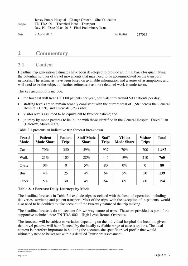
Headline trip generation estimates have been developed to provide an initial basis for quantifying the potential number of travel movements that may need to be accommodated on the transport networks. The estimates have been based on available information and a series of assumptions, and will need to be the subject of further refinement as more detailed work is undertaken.
The key assumptions include:
• the hospital will treat 180,000 patients per year, equivalent to around 500 patients per day;
• staffing levels are to remain broadly consistent with the current total of 1,587 across the GeneralHospital (1,330) and Overdale (257) sites;
• visitor levels assumed to be equivalent to two per patient; and
• journey by mode patterns to be in line with those identified in the General Hospital Travel Plan(Halcrow, March 2005).
Table 2.1 presents an indicative trip forecast breakdown.
Travel Mode
Patient Mode Share
Patient Trips
Staff Mode Share
Staff Trips
Visitor Mode Share
Visitor Trips
Total
Car 70% 350 59% 937 70% 700 1,987
Walk 21% 105 28% 445 19% 210 760
Cycle 0% 0 5% 80 0% 0 80
Bus 4% 25 4% 64 5% 50 139
Other 5% 30 4% 64 6% 60 154
Table 2.1: Forecast Daily Journeys by Mode
The headline forecasts in Table 2.1 exclude trips associated with the hospital operation, including deliveries, servicing and patient transport. Most of the trips, with the exception of in-patients, would also need to be doubled to take account of the two-way nature of the trip making.
The headline forecasts do not account for two way nature of trips. These are provided as part of the supportive technical note TN-TRA-002 – High Level Routes Overview.
The forecasts will be subject to variation depending on the individual hospital site location, given that travel patterns will be influenced by the locally available range of access options. The local context is therefore important in building the accurate site specific travel profile that would ultimately need to be set out within a detailed Transport Assessment.

Subject
Jersey Future Hospital – Change Order 4 – Site Validation
TN-TRA-001– Technical Note - Transport
Rev. P3. Date 02.04.2015. Final Preliminary Issue
Date 2 April 2015 Job No/Ref 237035
J:\237000\237035-00\4 INTERNAL PROJECT DATA\4-50 REPORTS\CHANGE ORDER 4 - SITE VALIDATION\TECHNICAL NOTES\TRANSPORT\TN-TRA-001 - TRANSPORT OPTIONS
APPRAISAL - P3.DOCX
Page 3 of 17Arup | F0.13
Working shift periods and the scheduling of appointments/visits have a key bearing on the time of travel and spread of demand throughout a day. An approach for patient and visitor timetabling will be adopted in future design stages that seeks to achieve a dispersed distribution in the demand for travel to/from the hospital at times that do not coincide with the traditional commuter peaks will offer potential advantages due to the less intensive impact on transport infrastructure.

Subject
Jersey Future Hospital – Change Order 4 – Site Validation
TN-TRA-001– Technical Note - Transport
Rev. P3. Date 02.04.2015. Final Preliminary Issue
Date 2 April 2015 Job No/Ref 237035
J:\237000\237035-00\4 INTERNAL PROJECT DATA\4-50 REPORTS\CHANGE ORDER 4 - SITE VALIDATION\TECHNICAL NOTES\TRANSPORT\TN-TRA-001 - TRANSPORT OPTIONS
APPRAISAL - P3.DOCX
Page 4 of 17Arup | F0.13
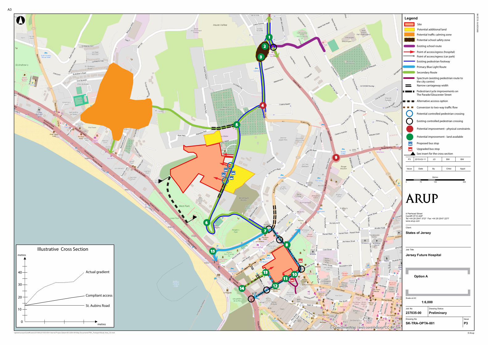
2.2 Option A
Drawing SK-TRA-OPTA-001/P3 identifies the following potential required off-site transport improvements:
1. upgrading of the St. John’s Road/Queens Road junction to a traffic signalled arrangement to provide dedicated opportunities for turning traffic to manoeuvre (subject to third party land acquisition);
2. provision of a controlled pedestrian crossing facility, additional signage and road markings/surfacing at the northern end of St. John’s Road as part of a school safety zone serving the route to D’Auvergne School;
3. provision of a controlled pedestrian crossing facility as part of a school safety zone serving the route to D’Auvergne School;
4. approach widening and/or conversion to traffic signals of the Tower Road/St. John’s Road junction to create additional queuing capacity (subject to third party land acquisition);
5. re-configuration of the priority arrangement at the Westmount Road/Tower Road junction to afford priority to movement between Westmount Road and the eastern section of Tower Road and incorporate improved pedestrian facilities;
6. provision of a controlled pedestrian crossing facility on Westmount Road;
7. upgrading of the Westmount Road/Peirson Road junction to a traffic signalled arrangement to provide dedicated opportunities for turning traffic to manoeuvre;
8. provision of a controlled crossing facility to facilitate pedestrian movement between the site and the Elizabeth Place corridor;
9. enlargement and widening of the Rouge Boullion roundabout;
10. provision of a controlled crossing facility to facilitate pedestrian movement between the site and the dedicated Spectrum route leading to the town centre;
11. provision of a controlled crossing facility to facilitate pedestrian movement between the site and the dedicated Spectrum route leading to the town centre;
12. kerbline adjustments and alterations to road markings at the Newgate Street/Gloucester Street junction to facilitate the two-way operation of Newgate Street;
13. kerbline adjustments at the Newgate Street/Patriotic Street junction to facilitate conversion to two-way traffic flow, with access to/from the northern section of Newgate Street to be restricted to blue light vehicles using a barrier or bollard arrangement;
14. potential installation of traffic signals at the A1/Patriotic Street junction to facilitate two-way operation and turning movements in all directions; and
15. modifications to the St. Aubin’s Road roundabout to create additional queuing capacity on the section of road leading from the A1, together with any associated adjustments to traffic signal timings.
Please refer to Options B and C for full commentary. Additional points to note are:

Subject
Jersey Future Hospital – Change Order 4 – Site Validation
TN-TRA-001– Technical Note - Transport
Rev. P3. Date 02.04.2015. Final Preliminary Issue
Date 2 April 2015 Job No/Ref 237035
J:\237000\237035-00\4 INTERNAL PROJECT DATA\4-50 REPORTS\CHANGE ORDER 4 - SITE VALIDATION\TECHNICAL NOTES\TRANSPORT\TN-TRA-001 - TRANSPORT OPTIONS
APPRAISAL - P3.DOCX
Page 5 of 17Arup | F0.13
• The configuration of acute health care provision has been focused at JGH in view of the better road connectivity to the A1/A2 primary routes for blue light vehicles and relative proximity to St. Helier built-up area.
• This could be further enhanced through potential conversion of Patriotic Street to a two-way operation and the reconfiguration of the A1/Patriotic Street junction to enable turning movements to be made in all directions (improvement no.14). This approach would achieve a greater degree of resilience in the event that the route via Newgate Street/Gloucester Street became blocked.
• The split site arrangement will create an element of travel demand between the two locations. This could be most appropriately accommodated through the provision of a direct interconnecting bus service. There may be scope to adapt a public service to serve this purpose, as an alternative to providing a bespoke shuttle bus which may attract low levels of demand at certain times of day.
• The orientation of the car parking layout at Overdale relies on an existing access arrangement that is positioned in close proximity to the crematorium entrance. This enables a substantial proportion of pedestrian movement to be contained within the site rather than requiring movement along or across Westmount Road.
Subject
Jersey Future Hospital – Change Order 4 – Site Validation
TN-TRA-001– Technical Note - Transport
Rev. P3. Date 02.04.2015. Final Preliminary Issue
Date 2 April 2015 Job No/Ref 237035
J:\237000\237035-00\4 INTERNAL PROJECT DATA\4-50 REPORTS\CHANGE ORDER 4 - SITE VALIDATION\TECHNICAL NOTES\TRANSPORT\TN-TRA-001 - TRANSPORT OPTIONS
APPRAISAL - P3.DOCX
Page 6 of 17Arup | F0.13
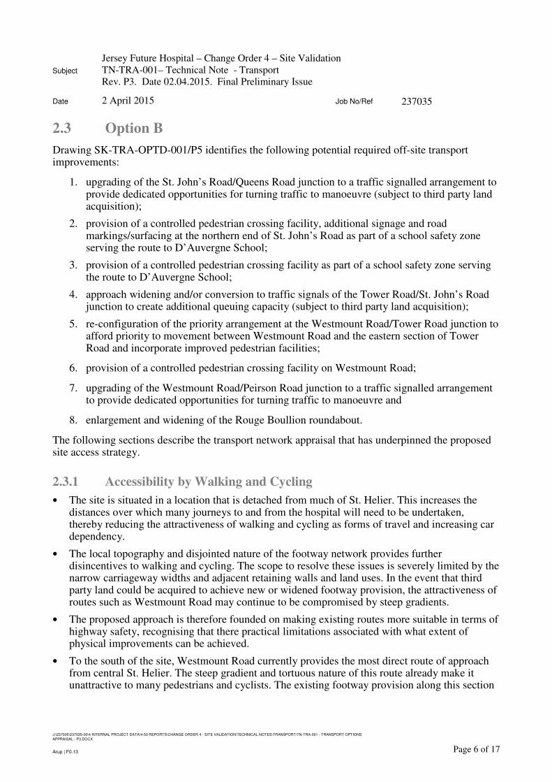
2.3 Option B
Drawing SK-TRA-OPTD-001/P5 identifies the following potential required off-site transport improvements:
1. upgrading of the St. John’s Road/Queens Road junction to a traffic signalled arrangement to provide dedicated opportunities for turning traffic to manoeuvre (subject to third party land acquisition);
2. provision of a controlled pedestrian crossing facility, additional signage and road markings/surfacing at the northern end of St. John’s Road as part of a school safety zone serving the route to D’Auvergne School;
3. provision of a controlled pedestrian crossing facility as part of a school safety zone serving the route to D’Auvergne School;
4. approach widening and/or conversion to traffic signals of the Tower Road/St. John’s Road junction to create additional queuing capacity (subject to third party land acquisition);
5. re-configuration of the priority arrangement at the Westmount Road/Tower Road junction to afford priority to movement between Westmount Road and the eastern section of Tower Road and incorporate improved pedestrian facilities;
6. provision of a controlled pedestrian crossing facility on Westmount Road;
7. upgrading of the Westmount Road/Peirson Road junction to a traffic signalled arrangement to provide dedicated opportunities for turning traffic to manoeuvre and
8. enlargement and widening of the Rouge Boullion roundabout.
The following sections describe the transport network appraisal that has underpinned the proposed site access strategy.
2.3.1 Accessibility by Walking and Cycling
• The site is situated in a location that is detached from much of St. Helier. This increases the distances over which many journeys to and from the hospital will need to be undertaken, thereby reducing the attractiveness of walking and cycling as forms of travel and increasing car dependency.
• The local topography and disjointed nature of the footway network provides further disincentives to walking and cycling. The scope to resolve these issues is severely limited by the narrow carriageway widths and adjacent retaining walls and land uses. In the event that third party land could be acquired to achieve new or widened footway provision, the attractiveness of routes such as Westmount Road may continue to be compromised by steep gradients.
• The proposed approach is therefore founded on making existing routes more suitable in terms of highway safety, recognising that there practical limitations associated with what extent of physical improvements can be achieved.
• To the south of the site, Westmount Road currently provides the most direct route of approach from central St. Helier. The steep gradient and tortuous nature of this route already make it unattractive to many pedestrians and cyclists. The existing footway provision along this section

Subject
Jersey Future Hospital – Change Order 4 – Site Validation
TN-TRA-001– Technical Note - Transport
Rev. P3. Date 02.04.2015. Final Preliminary Issue
Date 2 April 2015 Job No/Ref 237035
J:\237000\237035-00\4 INTERNAL PROJECT DATA\4-50 REPORTS\CHANGE ORDER 4 - SITE VALIDATION\TECHNICAL NOTES\TRANSPORT\TN-TRA-001 - TRANSPORT OPTIONS
APPRAISAL - P3.DOCX
Page 7 of 17Arup | F0.13
of Westmount Road is also single-sided and discontinuous, requiring pedestrians to cross the road on at least two occasions. This can be addressed through the provision of controlled crossing facilities to the north of the hairpin bend (improvement no.6) and as an integrated part of the site access arrangements.
• To the north of the site, the gradient of Westmount Road is better suited to walking and cycling journeys from the local area. The footway provision is single-sided, requiring pedestrians to cross in the vicinity of the site in order to access the footway. These movements can be facilitated through the provision of a controlled crossing facility as an integrated part of the site access arrangements.
• The section of Tower Road to the east of the Westmount Road junction also features single-sided footway provision, requiring pedestrians to cross if proceeding to/from the St. John’s Road direction. Crossing facilities will therefore need to be provided as part of the reconfiguration of the junction. Further to the west Tower Road features footways on both sides of the carriageway.
• The northern end of St. John’s Road has disjointed footway provision that requires pedestrians to cross on two occasions. It also coincides with a prominent school route that extends to D’Auvergne School. Controlled crossing facilities forming part of a school safety zone are likely to be required, in view of the potential implications of additional hospital traffic (including blue light vehicles) on conditions for pedestrians in this area (improvement no.2 and no.3).
• The scope to achieve alternative routes for pedestrian/cycle access via West Park/St. Aubin’s Road is compromised by the steepness of the gradient in this area.
2.3.2 Accessibility by Public Transport
• The site is currently served by one bus service (No. 19) that runs southbound along Westmount Road on an hourly basis to Liberation Bus Station. The service does not operate during evening periods and Sundays. Service provision will need to be upgraded, both in terms of coverage and frequency if public transport is to provide a viable travel option for a greater proportion of hospital journeys.
• Any upgrade could be concentrated on the frequency and duration over which services to/from Liberation Bus Station in St. Helier operate, in view of the opportunities that already exist to inter-connect with other island-wide services. The additional journey time associated with interchanging between connecting services may deter some hospital users from using the bus in preference to the car.
• A more desirable scenario is to reconfigure the existing bus network in such a way that affords the hospital direct access to a more extensive range of services. This would achieve a level of service befitting a modern hospital and requires further dialogue with TTS, the Parishes and Liberty Bus. Any decision making would need to be mindful of the physical limitations of the local road network and potential implications on existing service passengers.
• Bus stops incorporating passenger formal passenger waiting facilities, including a shelter, seating, timetable information and kerbing suitable for low floor access, will need to be positioned prominently in relation to the main building entrance.

Subject
Jersey Future Hospital – Change Order 4 – Site Validation
TN-TRA-001– Technical Note - Transport
Rev. P3. Date 02.04.2015. Final Preliminary Issue
Date 2 April 2015 Job No/Ref 237035
J:\237000\237035-00\4 INTERNAL PROJECT DATA\4-50 REPORTS\CHANGE ORDER 4 - SITE VALIDATION\TECHNICAL NOTES\TRANSPORT\TN-TRA-001 - TRANSPORT OPTIONS
APPRAISAL - P3.DOCX
Page 8 of 17Arup | F0.13
2.3.3 Road Access
• The key priority was identified as achieving a direct route of connection to the primary route network for blue light vehicles that minimises the use of narrow local roads susceptible to delays or blockages.
• The southern section of Westmount Road, although providing connectivity to the A1/A2, has a narrow carriageway width, steep gradient and sharp bends that make it unsuitable for use by high speed vehicles. As noted in section 2.3.1, the widening or re-profiling of this route to resolve these issues is unlikely to be achievable. Major changes to the traffic flow system, including the creation of a one-way loop were also discounted due to route suitability and the lengthy nature of the required detours for local users.
• Direct access to the A1 via St. Aubin’s Road would require a new road link that overcomes the steep 1 in 3 gradient. This would necessitate a tortuous road alignment to achieve a suitable 1 in 20 gradient (assuming a footway is included) and extensive retaining wall structures. The required length of road could negate any journey time advantages associated with achieving direct connectivity to St. Aubins Road and has a bearing on the degree of visual impact. Accordingly, this means of access does not represent the preferred access strategy.
• Use of the western section of Tower Road as a route of access to the A1 would involve a narrow carriageway width and undesirable traffic movements through a residential area.
• The orientation of blue light access towards the A9 (Queens Road) is therefore more appropriate, given that the existing route via Westmount Road, Tower Road and St. John’s Road utilises sections of carriageway with a better width and forward visibility.
• On this basis the emergency vehicle access has been positioned on Westmount Road towards the northern end of the site to facilitate blue light movement to/from the A9. Network resilience will be achieved in how blue light vehicles will also be able to route via Westmount Road to the south and Tower Road to the west in the event that the route to Queens Road is blocked.
• Secondary access for the public, staff and service vehicles has been located further to the south along Westmount Road. This utilises the established Overdale access junctions and accommodates access to/from the new car park. The separation of the car park junctions accommodates the provision of a controlled crossing facility to facilitate pedestrian movement between the car park and the hospital buidlings.
2.3.4 Wider Road Network
• The required network improvements are primarily focused on achieving suitable route connectivity to the A9 by resolving the existing junction constraints. The intensification of traffic movements created by the hospital on this part of the network will require road improvements to minimise delays, maintain highway safety and achieve effective movement by blue light vehicles.
• The change in the balance of traffic flows at the Westmount Road/Tower Road junction may warrant a change in the existing priority arrangement at this location, such that eastbound road users on Tower Road would be required to give way (improvement no.5). This suitability of this improvement will be dependent on the available visibility sightlines, which are to some extent obscured by adjacent walls.

Subject
Jersey Future Hospital – Change Order 4 – Site Validation
TN-TRA-001– Technical Note - Transport
Rev. P3. Date 02.04.2015. Final Preliminary Issue
Date 2 April 2015 Job No/Ref 237035
J:\237000\237035-00\4 INTERNAL PROJECT DATA\4-50 REPORTS\CHANGE ORDER 4 - SITE VALIDATION\TECHNICAL NOTES\TRANSPORT\TN-TRA-001 - TRANSPORT OPTIONS
APPRAISAL - P3.DOCX
Page 9 of 17Arup | F0.13
• The availability of additional car parking for users of the Crematorium could also help to alleviate localised congestion and obstructive on-street parking in this area.
• Creating additional queuing capacity at the Tower Road/St. John’s Road junction is more problematic due to the lack of available highway land. In order to alleviate the potential delays associated with right turning vehicles blocking back, approach widening and/or traffic signals are likely to be required (improvement no. 4). The deliverability of any improvement at this location will be dependent on land acquisition.
• A similar situation exists at the St. John’s Road/A9 junction, although there are adjacent verges that are the subject of a difference in ground levels. Due to the busy nature of the A9 at peak periods, signal control and approaching widening is likely to be required to afford dedicated opportunities for turning vehicles (improvement no.1).
• To the south of the St. John’s Road junction, the A9 provides a key link to central and eastern parts of St. Helier. The Rouge Boullion roundabout represents a key node on the St. Helier ring road and is therefore likely to require widening of the approaches to maintain traffic flow (improvement no.8). The deliverability of such improvements would be dependent on third party land acquisition. Part-time traffic signals may provide an alternative means of managing traffic flow during busy periods.
• Elsewhere on the network, there would be an increase in traffic movements on the southern part of Westmount Road as this forms a direct route to/from central St. Helier. The installation of traffic signals at the Peirson Road junction is likely to be necessary to create dedicated turning and lane change opportunities for traffic exiting Westmount Road (improvement no.7).
• There may also need to be additional traffic calming implemented in the Bellozane Valley and First Tower areas to discourage the use of residential streets such as Tower Road, Bellozane Road and Es Nouaux Road by hospital traffic.

Subject
Jersey Future Hospital – Change Order 4 – Site Validation
TN-TRA-001– Technical Note - Transport
Rev. P3. Date 02.04.2015. Final Preliminary Issue
Date 2 April 2015 Job No/Ref 237035
J:\237000\237035-00\4 INTERNAL PROJECT DATA\4-50 REPORTS\CHANGE ORDER 4 - SITE VALIDATION\TECHNICAL NOTES\TRANSPORT\TN-TRA-001 - TRANSPORT OPTIONS
APPRAISAL - P3.DOCX
Page 10 of 17Arup | F0.13
2.4 Option C
Drawing SK-TRA-OPTD-002/P2 identifies the proposed site access strategy and potential wider off-site improvements. The improvements are:
1. modifications to the St. Aubin’s Road roundabout to create additional queuing capacity on the section of road leading from the A1, together with any associated adjustments to traffic signal timings;
2. rationalisation of the Kensington Street/St. Aubin’s Road junction arrangement through the provision of traffic signals, to incorporate pedestrian crossing facilities;
3. provision of signage and kerb realignments to support the implementation of a ‘no waiting zone’ along Kensington Street, including the Lewis Street junction;
4. alterations to road markings to prioritise the northbound movement from Kensington Place to Kensington Street;
5. creation of a new Newgate Street/Kensington Place junction, with access to/from Newgate Street to be restricted to blue light vehicles using a barrier or bollard arrangement;
6. kerbline adjustments at the Newgate Street/Patriotic Street junction to facilitate conversion to two-way traffic flow, with access to/from the northern section of Newgate Street to be restricted to blue light vehicles using a barrier or bollard arrangement;
7. kerbline adjustments and alterations to road markings at the Newgate Street/Gloucester Street junction to facilitate the two-way operation of Newgate Street;
8. provision of a controlled crossing facility to facilitate pedestrian movement between the site and the dedicated Spectrum route leading to the town centre;
9. provision of a controlled crossing facility to facilitate pedestrian movement between the site and the dedicated Spectrum route leading to the town centre; and
10. provision of a controlled crossing facility to facilitate pedestrian movement between the site and the Elizabeth Place corridor.
The following sections describe the transport network appraisal that has underpinned the proposed site access strategy.
2.4.1 Accessibility by Walking and Cycling
• The site interfaces with Gloucester Street and The Parade were identified as forming key pedestrian/cycle desire lines in how they provide onward connectivity to the town centre, waterfront area and Parade Gardens.
• Both of these roads feature wide carriageways with two running lanes of traffic and on-street parking bays. Formal crossing provision is currently limited. The Parade has two signal controlled crossings, in the vicinity of the Gloucester Street and Lewis Street junctions. The Elizabeth Place interchange incorporates uncontrolled refuge islands that facilitate staggered crossing movements in this area. Gloucester Street has controlled crossing facilities at the Patriotic Place and Esplanade junctions and an uncontrolled refuge island at the interchange with The Parade.
Subject
Jersey Future Hospital – Change Order 4 – Site Validation
TN-TRA-001– Technical Note - Transport
Rev. P3. Date 02.04.2015. Final Preliminary Issue
Date 2 April 2015 Job No/Ref 237035
J:\237000\237035-00\4 INTERNAL PROJECT DATA\4-50 REPORTS\CHANGE ORDER 4 - SITE VALIDATION\TECHNICAL NOTES\TRANSPORT\TN-TRA-001 - TRANSPORT OPTIONS
APPRAISAL - P3.DOCX
Page 11 of 17Arup | F0.13
• The proposed orientation of the main hospital access onto Gloucester Street is intended to capitalise on the potential for many hospital journeys to be undertaken on foot or by bicycle. Blue light access has been orientated away from this area as part of helping to create conditions that are conducive to pedestrian/cycle movement.
• The site frontages onto Gloucester Street and Parade may provide an opportunity to widen the existing footway provision to achieve improved access for both pedestrians and cyclists. Advanced cycle stop lines at junctions and way-finding signage could also help to encourage these forms of travel.
• The provision of additional controlled crossing facilities is also important in creating direct linkages that afford priority of movement over road traffic. The Elizabeth Place and Spectrum corridors have been identified as key desire lines where this form of provision could be appropriate (improvement no.8, no.9 and no.10).
2.4.2 Accessibility by Public Transport
• The site is well placed in relation to Liberation Bus Station, with a walking distance of around 600 metres. The Bus Station functions as the main hub for all island-wide services.
• Although buses do operate along The Parade and Gloucester Street, the level of service is limited in terms of frequency and coverage. The one-way operation of these roads also means that the bus stops are not nearside to the hospital, reinforcing the need for additional pedestrian crossing provision.
• There may be scope to reconfigure the existing bus network in such a way that could afford the hospital direct access to a more extensive range of services. This would achieve a level of service befitting a modern hospital and requires further dialogue with TTS, the Parishes and Liberty Bus. Any decision making would need to be mindful of the potential implications on existing service passengers.
• The routing of bus services via Newgate Street could be explored in view of the new opportunities presented by the proposed conversion of this road to a two-way operation. This could include shared use of the proposed barrier/bollard controlled section with emergency vehicles.
• Any new or existing bus stops will need to be upgraded to provide formal passenger waiting facilities, including a shelter, seating, timetable information and kerbing suitable for low floor access.
2.4.3 Road Access
• The one-way traffic flow operation of the immediate road network poses a constraint in how it limits the available route choice and compromises network resilience in the event that a route becomes blocked.
• In the context of blue light vehicles it was recognised that resilience would be critical within an urban environment to ensure that there are multiple routes of access to/from the primary road network.
• This has influenced the orientation of the emergency access onto Newgate Street, in conjunction with the conversion and extension of Newgate Street to achieve two-way connectivity between
Subject
Jersey Future Hospital – Change Order 4 – Site Validation
TN-TRA-001– Technical Note - Transport
Rev. P3. Date 02.04.2015. Final Preliminary Issue
Date 2 April 2015 Job No/Ref 237035
J:\237000\237035-00\4 INTERNAL PROJECT DATA\4-50 REPORTS\CHANGE ORDER 4 - SITE VALIDATION\TECHNICAL NOTES\TRANSPORT\TN-TRA-001 - TRANSPORT OPTIONS
APPRAISAL - P3.DOCX
Page 12 of 17Arup | F0.13
Kensington Place and Gloucester Street (improvement no 5 and no.6). Under this arrangement blue light vehicles can exit onto St. Aubins Road via Kensington Street, where there are onward links to the A1/A2 and A9. An alternative entry and exit route into Newgate Street will also be available from Gloucester Street, providing the required flexibility.
• These proposals minimise any implications on existing traffic flow arrangements given that access between Kensington Place and Newgate Street will be restricted to blue light vehicles only. The only key change is the conversion of Newgate Street to a two-way operation between the Gloucester Street and Patriotic Street junctions. A suitable turning facility and ‘access only’ signage would need to be provided for any general traffic proceeding northwards along Newgate Street. Adjustments to the kerblines and markings at the Newgate Street/Gloucester Street would also be required to accommodate this new arrangement (improvement no. 7). Access arrangements to/from the Patriotic Street car park would be unaffected.
• Secondary access for the public and staff would be provided via Gloucester Street and service access will be available via Kensington Place/The Parade. This approach is consistent with the current General Hospital arrangements and ties in with the proposed pick-up/drop-off facilities at Gloucester Street.
2.4.4 Wider Road Network
• The network improvements would primarily involve adjustments to existing junctions to reflect the conversion of Newgate Street to a two-way operation and ensure that Kensington Street provides an effective route of exit for emergency vehicles.
• In the case of Kensington Street the imperative will be to ensure the route can be kept free from obstructions and provide effective connectivity to the A1/A2/A9 for blue light vehicles. This will necessitate an alteration to the priority arrangement at the junction with Kensington Place (improvement no. 4), kerbline adjustments and signage to raise awareness of the ‘no waiting’ route operation (improvement no. 3) and installation of traffic signals at the junction with St. Aubin’s Road junction (improvement no.2).
• The key A1/A2 interchange, including the St. Aubin’s Road roundabout, is also likely to require improvement to create additional queuing capacity and improve traffic flow to/from the A1/A2 dual carriageway (improvement no.1).

Subject
Jersey Future Hospital – Change Order 4 – Site Validation
TN-TRA-001– Technical Note - Transport
Rev. P3. Date 02.04.2015. Final Preliminary Issue
Date 2 April 2015 Job No/Ref 237035
J:\237000\237035-00\4 INTERNAL PROJECT DATA\4-50 REPORTS\CHANGE ORDER 4 - SITE VALIDATION\TECHNICAL NOTES\TRANSPORT\TN-TRA-001 - TRANSPORT OPTIONS
APPRAISAL - P3.DOCX
Page 13 of 17Arup | F0.13
2.5 Option D
Drawing SK-TRA-OPTD-001/P3 identifies the following potential required off-site transport improvements:
1. Reconfiguration of the traffic signalled A1/A2 junction to achieve additional queuing capacity;
2. Provision of a new all-movements site access junction as part of a reconfiguration of the A1/Gloucester Street traffic signalled junction;
3. Adjustment of lane allocations and road markings at the A1/Esplanade junction to achieve an effective tie in with the revised A1/Gloucester Street arrangement;
4. Provision of a new pedestrian/cycle crossing facility, either in the form of a footbridge or an at-grade signal controlled facility;
5. Approach widening and/or conversion to traffic signals of the grade-separated A1/Castle Street/La Route du Port Elizabeth roundabout (subject to potential land acquisition and/or junction reconstruction);
6. Widening of the approaches to the La Route du Port Elizabeth/Rue de L’Etau roundabout to achieve additional queuing capacity; and
7. Widening of the approaches to the site access/Rue de L’Etau roundabout to achieve additional queuing capacity.
The following sections describe the transport network appraisal that has underpinned the proposed site access strategy.
2.5.1 Accessibility by Walking and Cycling
• The site is severed from most of the St. Helier built-up area by the four lane A1 dual carriageway, which currently acts as a barrier to freedom of movement by pedestrians/cyclists.
• The pedestrian desire line to/from the Patriotic Street car park is currently served by the signal controlled crossing point at the Gloucester Street junction.
• The pedestrian desire line from the Esplanade car park is currently served by the footway that runs alongside the underpass egress onto the westbound side of the A1.
• Pedestrians approaching from the south east can also currently utilise the zebra crossings on each of the slip roads at the grade separated Castle Street/Route du Port Elizabeth roundabout.
• Discussions with TTS have highlighted the potential need for additional crossing facilities to the south of the Esplanade junction (improvement no.4). This is to directly serve the route of approach from the town centre and Liberation Bus Station.
• The crossing will either need to achieve segregation from the A1 carriageway or afford priority of movement to pedestrians/cyclists. This implies that a footbridge or an at-grade signalised crossing could be required. The chosen form of crossing will be influenced by the associated visual impact and any consequential effects on traffic flow along the A1 corridor.
Subject
Jersey Future Hospital – Change Order 4 – Site Validation
TN-TRA-001– Technical Note - Transport
Rev. P3. Date 02.04.2015. Final Preliminary Issue
Date 2 April 2015 Job No/Ref 237035
J:\237000\237035-00\4 INTERNAL PROJECT DATA\4-50 REPORTS\CHANGE ORDER 4 - SITE VALIDATION\TECHNICAL NOTES\TRANSPORT\TN-TRA-001 - TRANSPORT OPTIONS
APPRAISAL - P3.DOCX
Page 14 of 17Arup | F0.13
• This approach assumes that an underpass form of crossing will not be appropriate, in view of the aspiration to achieve a prominent, direct and attractive route with good natural surveillance. No technical review of the existing underpass link has been undertaken, given that there is an extant planning consent for this to continue to function as a car park egress.
2.5.2 Accessibility by Public Transport
• The site is well placed in relation to Liberation Bus Station, with a walking distance of around 400 metres. The Bus Station functions the main hub for all island-wide services.
• Convenient accessibility to/from the Bus Station will be achieved via the existing footways along Esplanade and the new crossing facility on or over the A1. There is also an alternative pedestrian route available via the existing footway provision along Castle Street and the A1.
2.5.3 Road Access
• The proximity of the site to the A1 dual carriageway provides an opportunity to achieve direct connectivity to the primary road network. This affords advantages in terms of island-wide access for blue light vehicles.
• Any new junction arrangement onto the A1 needs to overcome the constraint associated with the dual carriageway road layout in order to facilitate direct movement to/from the eastbound carriageway. There is no scope to adapt or utilise the existing Esplanade car park underpass as this is safeguarded in its current form by an extant planning permission for a new underground car park. The underground car park proposal relies on the continued use of the underpass as a means of egress onto the A1.
• The Esplanade Masterplan (SoJ, March 2011) has identified a road arrangement to support the redevelopment of the Esplanade/Waterfront area. This involves lowering a section of the A1 dual carriageway to achieve underground access to car parking via a new roundabout junction. Whilst the likelihood of the Masterplan being implemented has receded due to changing economic circumstances, the proposals continue to carry weight until such time that it is formally rescinded.
• The road arrangement also has to overcome the potential flood risk, which could result in the site being inaccessible via the A1 in both directions in extreme circumstances. This was partially addressed in the Esplanade Masterplan through the provision of a tidal protection hump on the A1, which would provide a defence mechanism to the north west and thereby enable a single route of access to be maintained in the event of a flood.
• The disadvantage with the masterplan solution is that flooding could continue to inhibit access to/from the east. This would require an element of hospital traffic to take a circuitous route around St. Helier in order to use the section of A1 to the north west of site. This has implications on blue light response times, travel times and traffic conditions within the town centre.
• The feasibility of alternative options has therefore been the subject of a high level review to provide an understanding of whether a road access arrangement could be achieved that can fully overcome the flooding constraint. The initial options considered have included:
o raising of the A1 dual carriageway by up to 2 metres and the provision of slip roads to facilitate blue light entry and egress;
Subject
Jersey Future Hospital – Change Order 4 – Site Validation
TN-TRA-001– Technical Note - Transport
Rev. P3. Date 02.04.2015. Final Preliminary Issue
Date 2 April 2015 Job No/Ref 237035
J:\237000\237035-00\4 INTERNAL PROJECT DATA\4-50 REPORTS\CHANGE ORDER 4 - SITE VALIDATION\TECHNICAL NOTES\TRANSPORT\TN-TRA-001 - TRANSPORT OPTIONS
APPRAISAL - P3.DOCX
Page 15 of 17Arup | F0.13
o provision of raised slip road arrangements to facilitate multi-directional access and egress;
o strengthening of the sea defences and provision of the tidal protection hump; and
o provision of a new at-grade junction on the A1 in the form of a roundabout or traffic signalled arrangement.
• Those options that did not resolve the severance issue were discounted, resulting in two potential solutions:
o A strengthening and raising of the sea wall and relocation of the tidal protection hump further to the north west to prevent potential flooding and enable a new at-grade junction arrangement to be provided. This represents the preferred solution (improvement no.2).
o The provision of raised slip roads that will maintain access and egress from the A1 to the north west. This solution was discounted on account of the potential visual impact and circuitous diversion necessary for travel to/from the east during an extreme flood event.
• The preferred solution would need to be the subject of further investigation to confirm the extent of tidal protection required and what supporting improvements may be required on the highway network. Importantly, it capitalises on the advantages of direct access/egress to the A1 in all directions for blue light vehicles.
• Secondary access for the public, staff and service vehicles can be appropriately directed via La Route du Port Elizabeth and Rue de L’Etau. This route already benefits from two connections with the A1 in the form of the Castle Street interchange and the egress onto the westbound carriageway.
2.5.4 Wider Road Network
• The required network improvements will primarily be associated with accommodating the new junction arrangement onto the A1 and ensuring that traffic flow on this key route is maintained.
• The blue light functionality of the new junction will help to minimise the extent of any additional delays to other road users at this location. The signal operation can be configured to afford priority to blue light vehicles, thereby ensuring efficient movement to and from both sides of the A1 dual carriageway.
• The re-distribution of other hospital related trips will result in some increased pressure on the A1 corridor, which is likely to necessitate capacity improvements at key junctions. Of greatest importance are the key interchanges with the A2 and La Route du Port Elizabeth (improvements 1 and 4).
• The A1/A2 interchange provides a key linkage to northern parts of St. Helier and onward connectivity to other parts of the island (improvement no.1). The capacity of the junction is limited by the single lane available to northbound traffic and its relative proximity to the St. Aubin’s Road roundabout.
• The La Route du Port Elizabeth grade separated interchange functions as the route of access to the ferry terminal and Waterfront leisure facilities (improvement no.5). The junction is already susceptible to congestion during peak periods when a ferry has docked and passengers are disembarking. The March 2015 introduction of the new HSC Condor Liberation ferry on the UK route has created an increased carrying capacity (an uplift of 139 passengers and cars compared against the vessels previously operated), which will have a further bearing on road

Subject
Jersey Future Hospital – Change Order 4 – Site Validation
TN-TRA-001– Technical Note - Transport
Rev. P3. Date 02.04.2015. Final Preliminary Issue
Date 2 April 2015 Job No/Ref 237035
J:\237000\237035-00\4 INTERNAL PROJECT DATA\4-50 REPORTS\CHANGE ORDER 4 - SITE VALIDATION\TECHNICAL NOTES\TRANSPORT\TN-TRA-001 - TRANSPORT OPTIONS
APPRAISAL - P3.DOCX
Page 16 of 17Arup | F0.13
conditions. This will be most pronounced during the summer season at times where there may be an element of overlap with St. Malo ferry services.
Subject
Jersey Future Hospital – Change Order 4 – Site Validation
TN-TRA-001– Technical Note - Transport
Rev. P3. Date 02.04.2015. Final Preliminary Issue
Date 2 April 2015 Job No/Ref 237035
J:\237000\237035-00\4 INTERNAL PROJECT DATA\4-50 REPORTS\CHANGE ORDER 4 - SITE VALIDATION\TECHNICAL NOTES\TRANSPORT\TN-TRA-001 - TRANSPORT OPTIONS
APPRAISAL - P3.DOCX
Page 17 of 17Arup | F0.13
3 Risks/Opportunities
3.1 Risks
• This site appraisal has been based on an initial review of accessibility, taking account of the range of transport modes that will need to be accommodated. The improvements that have been identified are not definitive or exhaustive, given that they will need to be re-evaluated and confirmed through more detailed analysis and design.
• Appropriate agreement will need to be sought with TTS and the Parish of St. Helier, as the Highway Authorities responsible for the road network.
• Some improvements may only be deliverable with third party land acquisition or cooperation from third parties (e.g. Liberty Bus).
• The extent to which the scope of any transport improvements may need to extend to other parts of the island, given the intended island-wide function of the hospital.
3.2 Opportunities
• A comprehensive updating of the hospital Travel Plan will be required. This should be undertaken in parallel with the design process to ensure that sustainable travel is suitably ingrained in the design. A robust approach to travel planning may also reduce any off-site costs associated with mitigating traffic impact on the highway network.
• The site appraisal has assumed that there is an aspiration to achieve a standard of transport infrastructure befitting a modernised hospital facility. An alternative view founded on the new hospital being a replacement facility with an established travel demand could be taken to justify reduced transport provision, although this would be less likely to result in the optimum solution.
• The off-site transport provisions associated with the hospital are likely to achieve spin-off benefits for local communities and the wider travelling public.
4 Derogations
Not applicable.
Subject
Jersey Future Hospital – Change Order 4 – Site Validation
TN-TRA-003– Technical Note - Transport – High Level Route Overview
Rev. P1. Date 02.04.2015. Final Preliminary Issue
Date 2 April 2015 Job No/Ref 237035
J:\237000\237035-00\4 INTERNAL PROJECT DATA\4-50 REPORTS\CHANGE ORDER 4 - SITE VALIDATION\TECHNICAL NOTES\TRANSPORT\TN-TRA-003 - HIGH LEVEL ROUTE
OVERVIEW - P1.DOCX
Page 1 of 11Arup | F0.13
1 Introduction
This technical note has been prepared to document the findings associated with transport to support the preparation of the Site Validation Exercise that forms Change Request Nr. 4 as part of the Jersey Future Hospital Scheme.
The four options being reviewed are:
Option A - Dual Site Options
Option B - Overdale Hospital Site, 100% New Build Option
Option C - Existing General Hospital, 100% New Build Option
Option D - Waterfront Site, 100% New Build Option
The purpose of this note is to support the principal document, TN-TRA-001 – Transport, by providing indicative trip estimates for key approach routes to each site option.
This follows a request made by SoJ and TTS for initial trip estimates to be included in support of the packages of transport improvements identified in the principal document. The estimates are intended to provide an initial quantification of travel demand to inform the Site Validation Exercise. They should not be regarded as definitive in the absence of a more comprehensive Transport Assessment for each site that provides a more detailed assessment of trip routing patterns.
Specific focus has been afforded to car trips on the basis that these will have most bearing on the scope of road junction improvements required to support any given option.
This is an order of magnitude guide as to what order of numbers could be associated with routes for each option.
Subject
Jersey Future Hospital – Change Order 4 – Site Validation
TN-TRA-003– Technical Note - Transport – High Level Route Overview
Rev. P1. Date 02.04.2015. Final Preliminary Issue
Date 2 April 2015 Job No/Ref 237035
J:\237000\237035-00\4 INTERNAL PROJECT DATA\4-50 REPORTS\CHANGE ORDER 4 - SITE VALIDATION\TECHNICAL NOTES\TRANSPORT\TN-TRA-003 - HIGH LEVEL ROUTE
OVERVIEW - P1.DOCX
Page 2 of 11Arup | F0.13
2 Approach
Headline trip generation estimates have been developed to provide an initial basis for quantifying the potential number of travel movements that may need to be accommodated on the transport networks. The estimates have been based on available information and a series of assumptions, and will need to be the subject of further refinement as more detailed work is undertaken.
The key assumptions include:
• the hospital will treat 180,000 patients per year, equivalent to around 500 patients per day;
• staffing levels are to remain broadly consistent with the current total of 1,587 across the General Hospital (1,330) and Overdale (257) sites;
• visitor levels assumed to be equivalent to two per patient; and
• journey by mode patterns to be in line with those identified in the General Hospital Travel Plan (Halcrow, March 2005).
Table 1 presents an indicative trip forecast breakdown.
Travel Mode
Patient Mode Share
Patient Trips
Staff Mode Share
Staff Trips
Visitor Mode Share
Visitor Trips
Total
Car 70% 350 59% 937 70% 700 1,987
Walk 21% 105 28% 445 19% 210 760
Cycle 0% 0 5% 80 0% 0 80
Bus 4% 25 4% 64 5% 50 139
Other 5% 30 4% 64 6% 60 154
Table 1 - Forecast Daily Journeys by Mode
The headline forecasts in Table 1 exclude trips associated with the hospital operation, including deliveries, servicing and patient transport.
Most of the trips in Table 1, with the exception of in-patients, would need to be doubled to take account of the two-way nature of the trip making. This has been reflected in the subsequent sections of this report. Adjustments have been made where appropriate to reflect any site specific characteristics that are expected to influence travel behaviour.
The supporting drawings provide an illustration of the key routes identified for car travel to each site option. The apportioning of trips to routes has been broadly based on key centres of population, the attractiveness of the route (in terms of potential journey time) and expected car parking behaviours.
A percentage range has been provided in some cases due to the early nature of these works to provide an overall indication of possible numbers at this stage given the early nature of this exercise.
Subject
Jersey Future Hospital – Change Order 4 – Site Validation
TN-TRA-003– Technical Note - Transport – High Level Route Overview
Rev. P1. Date 02.04.2015. Final Preliminary Issue
Date 2 April 2015 Job No/Ref 237035
J:\237000\237035-00\4 INTERNAL PROJECT DATA\4-50 REPORTS\CHANGE ORDER 4 - SITE VALIDATION\TECHNICAL NOTES\TRANSPORT\TN-TRA-003 - HIGH LEVEL ROUTE
OVERVIEW - P1.DOCX
Page 3 of 11Arup | F0.13
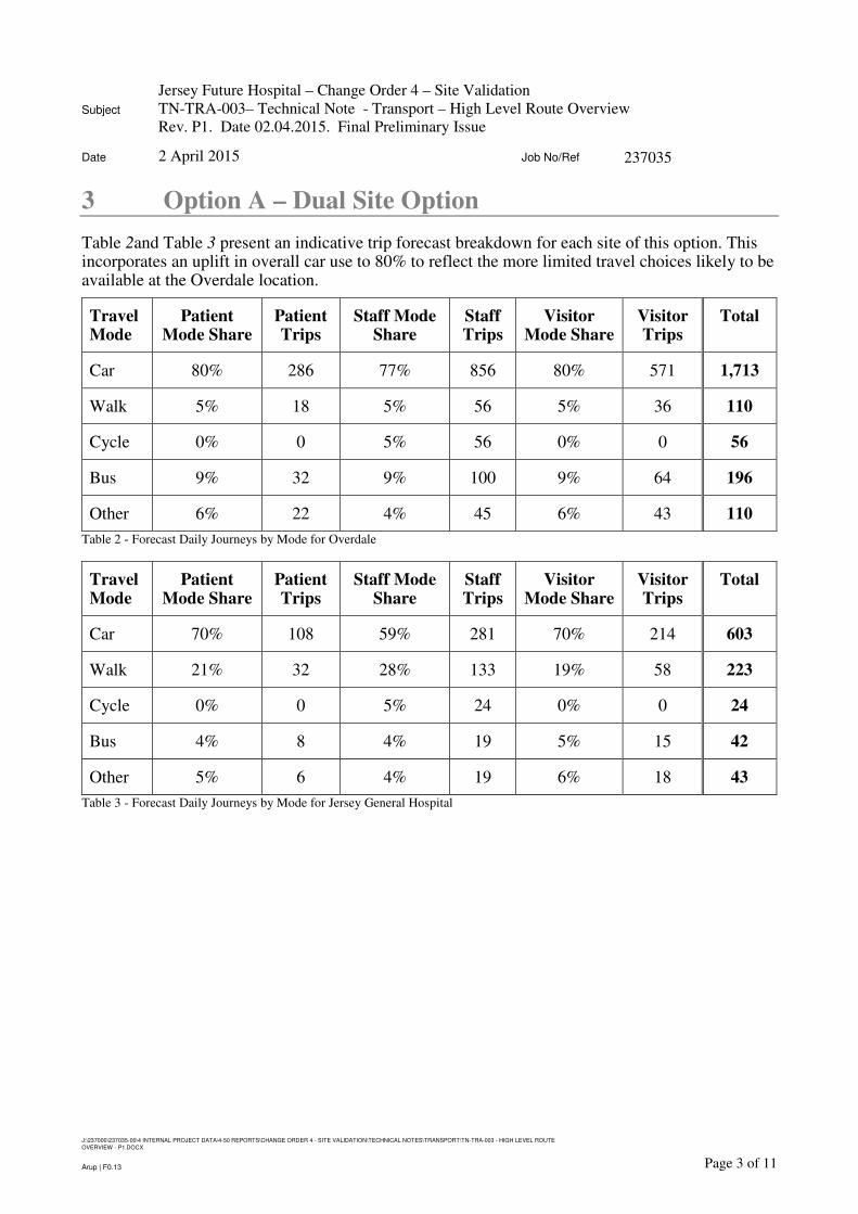
3 Option A – Dual Site Option
Table 2and Table 3 present an indicative trip forecast breakdown for each site of this option. This incorporates an uplift in overall car use to 80% to reflect the more limited travel choices likely to be available at the Overdale location.
Travel Mode
Patient Mode Share
Patient Trips
Staff Mode Share
Staff Trips
Visitor Mode Share
Visitor Trips
Total
Car 80% 286 77% 856 80% 571 1,713
Walk 5% 18 5% 56 5% 36 110
Cycle 0% 0 5% 56 0% 0 56
Bus 9% 32 9% 100 9% 64 196
Other 6% 22 4% 45 6% 43 110
Table 2 - Forecast Daily Journeys by Mode for Overdale
Travel Mode
Patient Mode Share
Patient Trips
Staff Mode Share
Staff Trips
Visitor Mode Share
Visitor Trips
Total
Car 70% 108 59% 281 70% 214 603
Walk 21% 32 28% 133 19% 58 223
Cycle 0% 0 5% 24 0% 0 24
Bus 4% 8 4% 19 5% 15 42
Other 5% 6 4% 19 6% 18 43
Table 3 - Forecast Daily Journeys by Mode for Jersey General Hospital
Subject
Jersey Future Hospital – Change Order 4 – Site Validation
TN-TRA-003– Technical Note - Transport – High Level Route Overview
Rev. P1. Date 02.04.2015. Final Preliminary Issue
Date 2 April 2015 Job No/Ref 237035
J:\237000\237035-00\4 INTERNAL PROJECT DATA\4-50 REPORTS\CHANGE ORDER 4 - SITE VALIDATION\TECHNICAL NOTES\TRANSPORT\TN-TRA-003 - HIGH LEVEL ROUTE
OVERVIEW - P1.DOCX
Page 4 of 11Arup | F0.13
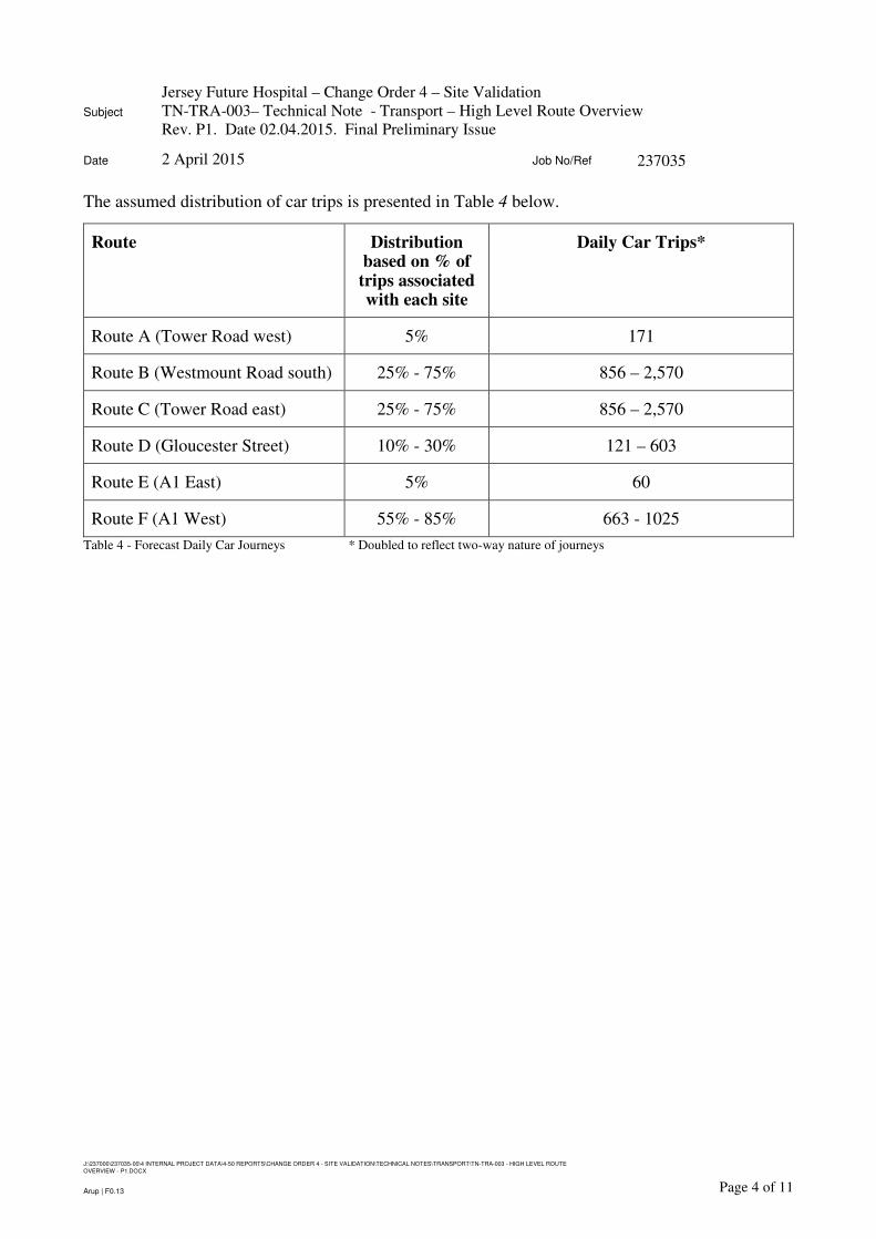
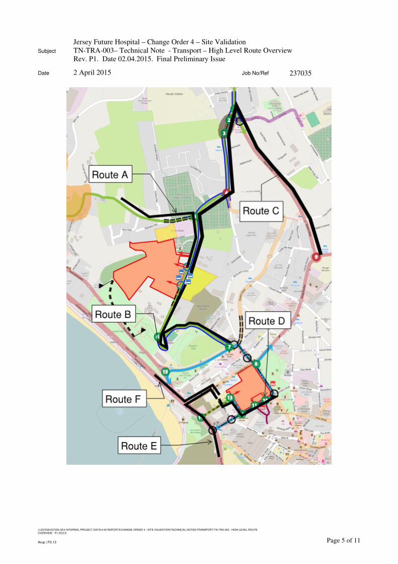
The assumed distribution of car trips is presented in Table 4 below.
Route Distribution based on % of
trips associated with each site
Daily Car Trips*
Route A (Tower Road west) 5% 171
Route B (Westmount Road south) 25% - 75% 856 – 2,570
Route C (Tower Road east) 25% - 75% 856 – 2,570
Route D (Gloucester Street) 10% - 30% 121 – 603
Route E (A1 East) 5% 60
Route F (A1 West) 55% - 85% 663 - 1025
Table 4 - Forecast Daily Car Journeys * Doubled to reflect two-way nature of journeys
Subject
Jersey Future Hospital – Change Order 4 – Site Validation
TN-TRA-003– Technical Note - Transport – High Level Route Overview
Rev. P1. Date 02.04.2015. Final Preliminary Issue
Date 2 April 2015 Job No/Ref 237035
J:\237000\237035-00\4 INTERNAL PROJECT DATA\4-50 REPORTS\CHANGE ORDER 4 - SITE VALIDATION\TECHNICAL NOTES\TRANSPORT\TN-TRA-003 - HIGH LEVEL ROUTE
OVERVIEW - P1.DOCX
Page 5 of 11Arup | F0.13

Subject
Jersey Future Hospital – Change Order 4 – Site Validation
TN-TRA-003– Technical Note - Transport – High Level Route Overview
Rev. P1. Date 02.04.2015. Final Preliminary Issue
Date 2 April 2015 Job No/Ref 237035
J:\237000\237035-00\4 INTERNAL PROJECT DATA\4-50 REPORTS\CHANGE ORDER 4 - SITE VALIDATION\TECHNICAL NOTES\TRANSPORT\TN-TRA-003 - HIGH LEVEL ROUTE
OVERVIEW - P1.DOCX
Page 6 of 11Arup | F0.13
4 Option B – Overdale
Table 5 presents an indicative trip forecast breakdown for this option. This incorporates an uplift in overall car use to 80% to reflect the more limited travel choices likely to be available at this location.
Travel Mode
Patient Mode Share
Patient Trips
Staff Mode Share
Staff Trips
Visitor Mode Share
Visitor Trips
Total
Car 80% 408 77% 1,224 80% 816 2,448
Walk 5% 26 5% 78 5% 51 155
Cycle 0% 0 5% 80 0% 0 80
Bus 9% 46 9% 144 9% 92 282
Other 6% 31 4% 64 6% 61 156
Table 5 - Forecast Daily Journeys by Mode
The assumed distribution of car trips is presented in Table 6 below.
Route Distribution Daily Car Trips*
Route A (Tower Road west) 5% 244
Route B (Westmount Road south) 25% - 75% 1,224 – 3,672
Route C (Tower Road east) 25% - 75% 1,224 – 3,672
Table 6 - Forecast Daily Car Journeys * Doubled to reflect two-way nature of journeys

Subject
Jersey Future Hospital – Change Order 4 – Site Validation
TN-TRA-003– Technical Note - Transport – High Level Route Overview
Rev. P1. Date 02.04.2015. Final Preliminary Issue
Date 2 April 2015 Job No/Ref 237035
J:\237000\237035-00\4 INTERNAL PROJECT DATA\4-50 REPORTS\CHANGE ORDER 4 - SITE VALIDATION\TECHNICAL NOTES\TRANSPORT\TN-TRA-003 - HIGH LEVEL ROUTE
OVERVIEW - P1.DOCX
Page 7 of 11Arup | F0.13

Subject
Jersey Future Hospital – Change Order 4 – Site Validation
TN-TRA-003– Technical Note - Transport – High Level Route Overview
Rev. P1. Date 02.04.2015. Final Preliminary Issue
Date 2 April 2015 Job No/Ref 237035
J:\237000\237035-00\4 INTERNAL PROJECT DATA\4-50 REPORTS\CHANGE ORDER 4 - SITE VALIDATION\TECHNICAL NOTES\TRANSPORT\TN-TRA-003 - HIGH LEVEL ROUTE
OVERVIEW - P1.DOCX
Page 8 of 11Arup | F0.13
5 Option C – Existing Jersey General Hospital Site
Table 7 presents an indicative trip forecast breakdown for this option.
Travel Mode
Patient Mode Share
Patient Trips
Staff Mode Share
Staff Trips
Visitor Mode Share
Visitor Trips
Total
Car 70% 350 59% 937 70% 700 1,987
Walk 21% 105 28% 445 19% 210 760
Cycle 0% 0 5% 80 0% 0 80
Bus 4% 25 4% 64 5% 50 139
Other 5% 30 4% 64 6% 60 154
Table 7 - Forecast Daily Journeys by Mode
The assumed distribution of car trips is presented in Table 8 below.
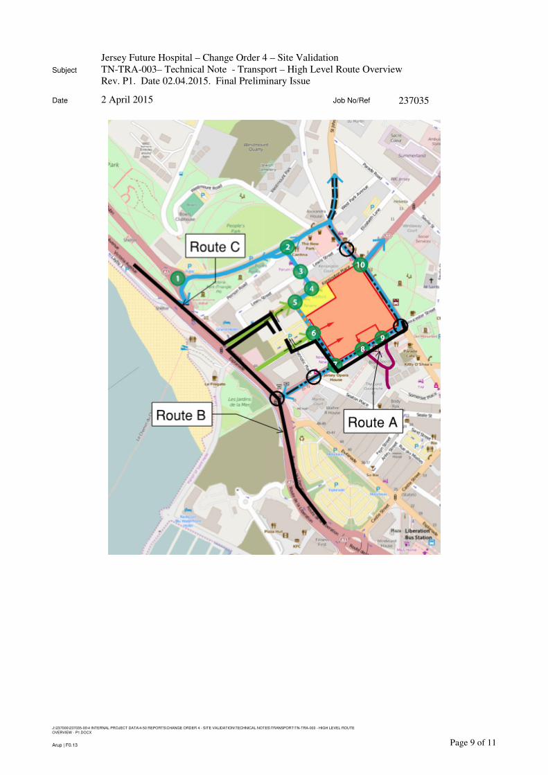
Route Distribution Daily Car Trips*
Route A (Gloucester Street) 10% - 30% 397 – 1,192
Route B (A1 East) 55% - 85% 2,186 – 3,378
Route C (A1 West) 5% 199
Table 8 - Forecast Daily Car Journeys * Doubled to reflect two-way nature of journeys
Subject
Jersey Future Hospital – Change Order 4 – Site Validation
TN-TRA-003– Technical Note - Transport – High Level Route Overview
Rev. P1. Date 02.04.2015. Final Preliminary Issue
Date 2 April 2015 Job No/Ref 237035
J:\237000\237035-00\4 INTERNAL PROJECT DATA\4-50 REPORTS\CHANGE ORDER 4 - SITE VALIDATION\TECHNICAL NOTES\TRANSPORT\TN-TRA-003 - HIGH LEVEL ROUTE
OVERVIEW - P1.DOCX
Page 9 of 11Arup | F0.13

Subject
Jersey Future Hospital – Change Order 4 – Site Validation
TN-TRA-003– Technical Note - Transport – High Level Route Overview
Rev. P1. Date 02.04.2015. Final Preliminary Issue
Date 2 April 2015 Job No/Ref 237035
J:\237000\237035-00\4 INTERNAL PROJECT DATA\4-50 REPORTS\CHANGE ORDER 4 - SITE VALIDATION\TECHNICAL NOTES\TRANSPORT\TN-TRA-003 - HIGH LEVEL ROUTE
OVERVIEW - P1.DOCX
Page 10 of 11Arup | F0.13
6 Option D – Waterfront Site
Table 9 presents an indicative trip forecast breakdown for this option.
Travel Mode
Patient Mode Share
Patient Trips
Staff Mode Share
Staff Trips
Visitor Mode Share
Visitor Trips
Total
Car 70% 350 59% 937 70% 700 1,987
Walk 21% 105 28% 445 19% 210 760
Cycle 0% 0 5% 80 0% 0 80
Bus 4% 25 4% 64 5% 50 139
Other 5% 30 4% 64 6% 60 154
Table 9 - Forecast Daily Journeys by Mode
The assumed distribution of car trips is presented in Table 10 below.
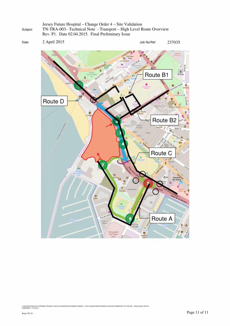
Route Distribution Daily Car Trips*
Route A (La Route du Port Elizabeth) 30% 1,192
Route B1 (Gloucester Street In) 10% - 30% (1 way)
199 – 596
Route B2 (Gloucester Street Out) 65% - 95% (1 way)
1,291 – 1,888
Route C (A1 East) 55% - 85% 2,186 – 3,378
Route D (A1 West) 5% 199
Table 10 - Forecast Daily Car Journeys * Doubled to reflect two-way nature of journeys unless otherwise stated
Subject
Jersey Future Hospital – Change Order 4 – Site Validation
TN-TRA-003– Technical Note - Transport – High Level Route Overview
Rev. P1. Date 02.04.2015. Final Preliminary Issue
Date 2 April 2015 Job No/Ref 237035
J:\237000\237035-00\4 INTERNAL PROJECT DATA\4-50 REPORTS\CHANGE ORDER 4 - SITE VALIDATION\TECHNICAL NOTES\TRANSPORT\TN-TRA-003 - HIGH LEVEL ROUTE
OVERVIEW - P1.DOCX
Page 11 of 11Arup | F0.13