January 2016 · Management Office (07) 5589 1100 Web Department of Infrastructure and Regional...
152
Gold Coast Airport Pty Ltd Instrument Landing System Major Development Plan | January 2016
Transcript of January 2016 · Management Office (07) 5589 1100 Web Department of Infrastructure and Regional...

Gold Coast Airport Pty Ltd
Instrument Landing System
Major Development Plan | January 2016
Notice
This Major Development Plan has been prepared by Gold Coast Airport Pty Ltd (GCAPL) in accordance with the requirements of the Airports Act 1996 (Cth). Whilst all care has been taken in the preparation of the Major Development Plan, GCAPL accepts no liability whatsoever to any person who relies in any way on any information contained in this Major Development Plan.
© Copyright
Copyright in this document vests in GCAPL. No section or element of this document may be removed from, reproduced, electronically stored or transmitted in any form without the written permission of GCAPL other than for the sole purpose of reviewing its contents.
Key Contacts
Gold Coast Airport Pty Ltd
Management Office (07) 5589 1100
Web www.goldcoastairport.com.au
Department of Infrastructure and Regional Development
Airport Building Controller (07) 3216 3040
Airport Environment Officer (07) 5536 8426
Airservices Australia
Noise Complaints and Information Service
1800 802 584 or 1300 302 240
Acknowledgements
GCAPL acknowledges the following for their contribution to this document:
Airservices Australia ARUP Pty Ltd Covec
Gold Coast Airport Pty Ltd
Instrument Landing System
Major Development Plan | January 2016

iv Gold Coast Airport | Major Development Plan
Contents
1.0 INTRODUCTION ....................................................................................... 2
1.1 THE PROJECT ............................................................................................................................................2
1.2 PROJECT LOCATION ..................................................................................................................................3
1.3 MAJOR DEVELOPMENT PLAN ....................................................................................................................7
1.4 PROJECT ROLES AND RESPONSIBILITIES .................................................................................................7
1.5 MAJOR DEVELOPMENT PLAN STRUCTURE ...............................................................................................7
2.0 THE DEVELOPMENT .............................................................................. 12
2.1 INSTRUMENT LANDING SYSTEM ..............................................................................................................12
2.1.1 DESCRIPTION OF ILS COMPONENTS .......................................................................................................12
2.1.2 HOW AN ILS WORKS ................................................................................................................................14
2.1.3 THE INSTALLATION OF AN ILS ON RUNWAY 14 ........................................................................................14
2.1.4 LAND TENURE FOR THE ILS .....................................................................................................................17
2.2 ILS DEVELOPMENT OBJECTIVES .............................................................................................................21
2.3 THE EXISTING SITUATION .........................................................................................................................21
2.3.1 INCLEMENT WEATHER AT GOLD COAST AIRPORT ..................................................................................21
2.3.2 INCLEMENT WEATHER CAPABILITY AT GOLD COAST AIRPORT ..............................................................22
2.3.3 HOW DO AIRCRAFT AT GOLD COAST AIRPORT CURRENTLY LAND ........................................................23
2.4 FUTURE NEEDS OF AIRCRAFT USERS .....................................................................................................25
2.5 WHY AN ILS ..............................................................................................................................................25
2.6 WHEN THE ILS WILL BE USED ..................................................................................................................26
2.7 HOW MUCH THE ILS WILL BE USED ........................................................................................................26
2.8 OUTCOME OF INSTALLING THE ILS ON RUNWAY 14 ...............................................................................28
2.8.1 BENEFITS OF AN ILS ................................................................................................................................28
2.8.2 REGULAR PUBLIC TRANSPORT (RPT) ......................................................................................................28
2.8.3 BENEFITS TO GENERAL AVIATION ............................................................................................................29
2.8.4 VEHICULAR TRAFFIC IMPACTS .................................................................................................................29
3.0 REGULATORY FRAMEWORK ................................................................ 32
3.1 INTRODUCTION ........................................................................................................................................32
3.2 RELEVANT LEGISLATION ..........................................................................................................................32
3.2.1 AIRPORTS ACT 1996 ................................................................................................................................32
3.2.2 ENVIRONMENT PROTECTION AND BIODIVERSITY CONSERVATION ACT 1999 ........................................34
3.2.3 THE AIR SERVICES ACT 1995 (CTH) .........................................................................................................34
3.2.4 CIVIL AVIATION ACT 1988 .........................................................................................................................35
3.3 CONSISTENCY WITH THE AIRPORT LEASE ..............................................................................................35
Major Development Plan | Gold Coast Airport v
3.4 CONSISTENCY WITH GOLD COAST AIRPORT MASTER PLAN..................................................................35
3.4.1 GENERAL ..................................................................................................................................................35
3.4.2 LAND USE IN THE MASTER PLAN .............................................................................................................36
3.5 CONSISTENCY WITH STATUTORY DOCUMENTS ......................................................................................38
3.5.1 STATE PLANNING LEGISLATION ...............................................................................................................38
3.6 CONSISTENCY WITH LOCAL PLANNING REGIMES ..................................................................................39
3.6.1 LAND USE AND ZONING IN TWEED SHIRE ...............................................................................................39
3.6.2 CITY OF GOLD COAST LAND USE AND ZONING ......................................................................................40
3.7 DEVELOPMENT AND BUILDING APPROVALS ...........................................................................................41
4.0 ECONOMIC AND REGIONAL SIGNIFICANCE ....................................... 44
4.1 INTRODUCTION ........................................................................................................................................44
4.2 ECONOMIC – IMMEDIATE BENEFITS .........................................................................................................44
4.2.1 ECONOMIC – LONG-TERM .......................................................................................................................44
4.3 REGIONAL SIGNIFICANCE ........................................................................................................................45
5.0 ENVIRONMENTAL ASSESSMENT ......................................................... 48
5.1 ASSESSMENT APPROACH .......................................................................................................................48
5.1.1 REVIEW OF BASELINE CONDITIONS .........................................................................................................49
5.1.2 IMPACT ASSESSMENT ..............................................................................................................................50
5.1.3 TERMINOLOGY .........................................................................................................................................51
5.2 RESOURCE USE .......................................................................................................................................51
5.3 LAND ........................................................................................................................................................52
5.3.1 BASELINE CONDITIONS ............................................................................................................................52
5.3.2 ASSESSMENT OF IMPACTS ......................................................................................................................52
5.4 SURFACE AND GROUNDWATER ...............................................................................................................56
5.4.1 BASELINE CONDITIONS ............................................................................................................................56
5.4.2 ASSESSMENT OF IMPACTS ......................................................................................................................56
5.5 HABITAT VALUES AND WILDLIFE CORRIDORS .........................................................................................58
5.5.1 BASELINE CONDITIONS ............................................................................................................................58
5.5.2 ASSESSMENT OF IMPACTS ......................................................................................................................61
5.6 SIGNIFICANT FLORA AND FAUNA .............................................................................................................67
5.6.1 BASELINE CONDITIONS ............................................................................................................................67
5.6.2 RESULTS OF THE HABITAT ASSESSMENT FOR WALLUM SEDGE FROG IN ESA IMPACT AREA A ............71
5.6.3 ASSESSMENT OF IMPACTS – SIGNIFICANT FLORA AND FAUNA ..............................................................74
5.7 CULTURAL HERITAGE ...............................................................................................................................76
5.7.1 BASELINE CONDITIONS ............................................................................................................................76
vi Gold Coast Airport | Major Development Plan
5.7.2 ASSESSMENT OF IMPACTS ......................................................................................................................76
5.8 AIR QUALITY, NOISE AND LIGHT ...............................................................................................................77
5.9 HAZARDOUS MATERIALS .........................................................................................................................77
5.10 MITIGATION MEASURES ...........................................................................................................................77
5.10.1 RESOURCE USE .......................................................................................................................................78
5.10.2 LAND ........................................................................................................................................................78
5.10.3 SURFACE AND GROUNDWATER ..............................................................................................................79
5.10.4 VEGETATION MANAGEMENT ....................................................................................................................79
5.10.5 SIGNIFICANT SPECIES MANAGEMENT .....................................................................................................80
5.10.6 CULTURAL HERITAGE ...............................................................................................................................80
5.10.7 AIR QUALITY, NOISE AND LIGHT ...............................................................................................................81
5.10.8 HAZARDOUS MATERIALS .........................................................................................................................81
5.11 CONCLUSION OF ENVIRONMENTAL IMPACT ...........................................................................................81
6.0 NOISE EXPOSURE ................................................................................. 88
6.1 FLIGHT PATH ............................................................................................................................................88
6.2 NOISE IMPACT ..........................................................................................................................................90
6.2.1 ASSESSMENT RESULTS ...........................................................................................................................90
6.2.2 AUSTRALIAN NOISE EXPOSURE FORECAST CONTOURS (ANEF) ...........................................................105
6.3 NOISE ABATEMENT ................................................................................................................................105
6.3.1 OTHER AMELIORATION MEASURES .......................................................................................................107
6.4 NOISE AND THE NATURAL ENVIRONMENT ............................................................................................107
7.0 CONSULTATION ................................................................................... 110
7.1 CONSULTATION PROCESS .....................................................................................................................110
7.2 COMMITMENT TO PROACTIVE CONSULTATION .....................................................................................110
7.3 CONSULTATION PRIOR TO THE PUBLIC COMMENT PERIOD .................................................................110
7.4 THE PUBLIC COMMENT PERIOD ............................................................................................................111
7.5 AFTER THE PUBLIC COMMENT PERIOD .................................................................................................111
8.0 APPENDIX A ......................................................................................... 114
9.0 APPENDIX B ......................................................................................... 136

Major Development Plan | Gold Coast Airport vii
Number Title
1.1 Location of Glidepath Footprint, Localiser Footprint and Runway Strip Widening
1.2 Schematic Layout of the Communications and Mains Power System
1.3 Existing Approaches on Runway 14
1.4 ILS Approach on Runway 14
2.1 Typical Localiser Installation
2.2 Typical Glidepath Installation
2.3 Schematic Representation of how Aircraft will use the ILS
2.4 Location of Runway 14 ILS and Associated Components
2.5 Glidepath Facilities
2.6 Localiser Facilities
2.7 300 Metre Runway Strip
2.8 Average Diversions by Month
2.9 Landing Approaches on Runway 14
3.1 ILS Approvals Process
3.2 2011 Master Plan Land Use Plan
5.1 Environmentally Significant Areas and ESA Impact Areas
5.2 Known Contaminated Land Sites, Cultural Heritage Sites and Site Drainage
5.3 Vegetation Communities in the Localiser Footprint
5.4 Historical (1975) Aerial Image of the Localiser Footprint with Current Aerial Image
5.5 Wetlands and Endangered Ecological Communities in the Localiser Footprint
6.1 Preliminary Flight Path
6.2 Regions of Environmental Impact
6.3 Single Event Noise Contours for A320 Aircraft
6.4 Single Event Noise Contours for A330 Aircraft
6.5 Daily N60 Noise Contour Map – Current
6.6 Daily N60 Noise Contour Map - ILS 10% Use Scenario
6.7 Daily N60 Noise Contour Map - ILS - 40% Use Scenario
6.8 Daily N60 Noise Contour Map – ILS 100% Use Scenario
6.9 Daily N70 Noise Contour Map - Current
6.10 Daily N70 Noise Contour Map - ILS 10% Use Scenario
6.11 Daily N70 Noise Contour Map – ILS 40% Use Scenario
6.12 Daily N70 Noise Contour Map - ILS 100% Use Scenario
6.13 Commonly Used Decibel Measurements for a Range of Everyday Noise Experiences
6.14 2031 Australian Noise Exposure Forecast (ANEF)
List of Figures
viii Gold Coast Airport | Major Development Plan
Number Title
1.1 Major Development Plan Requirements
2.1 ILS components
2.2 Precipitation at Gold Coast Airport
2.3 VOR/DME, RNP and ILS approach procedures
2.4 ILS frequency of use
5.1 Assessment criteria
5.2Estimate of current extent (hectares) for the subtropical and temperate coastal saltmarsh ecological community in New South Wales
5.3 Significant flora species that may occur within the 300 metre Runway Strip
5.4 Impact summary
6.1 Noise impacts – regions 1, 2 and 3
List of Tables

Major Development Plan | Gold Coast Airport ix
Term Definition
Acid Sulfate Soils Soils containing sulphide minerals which have potential to, or have already started to generate acid on oxidation. Actual acid sulfate soils is soil with a pH of four or less, and can usually be identified by the presence of yellow mottles and coatings of jarosite (iron sulfate).
Potential acid sulfate soils is soil which contains iron sulphides that have not been exposed to air or oxidised. Potential acid sulfate soils poses an environmental risk as it may become acidic when exposed to air.
Airport Activities Activity or activities undertaken by airport operator(s).
Air Traffic Control Air traffic control service provided by Airservices Australia.
Airport Building Controller (ABC)
Position appointed by the Secretary of the Federal Department of Infrastructure and Regional Development to administer regulatory functions in relation to airport building control matters.
Airport Environment Officer (AEO)
Position appointed by the Secretary of the Federal Department of Infrastructure and Regional Development to administer on site regulatory functions on behalf of the Department in relation to environmental matters.
Airport Operator A person or organisation operating a business; carrying out an activity, dealing, operation, process or work; and operation of any facility, plant, machine or equipment on Gold Coast Airport. Includes Gold Coast Airport Pty Ltd staff, all tenants and contractors.
Airside The movement area of an airport, adjacent terrain and buildings or portions thereof, access to which is controlled.
Alluvial Alluvial soil or sediment is that which has been transported and deposited by running water.
Apron The part of an airport used:
→ For the purpose of enabling passengers to board, or disembark from aircraft;
→ For loading cargo onto, or unloading cargo from, aircraft; and/or
→ For refuelling, parking or carrying out maintenance on aircraft.
Aquifer An aquifer is an underground layer of water-bearing permeable rock or unconsolidated materials (gravel, sand, silt, or clay) from which groundwater can be usefully extracted using a water well.
Code E Aircraft A code E aircraft is an aircraft that has a wingspan 52metres up to but not including 65 metres and an outer main gear span of 9 metres up to but not including 14 metres.
Glossary

x Gold Coast Airport | Major Development Plan
Contractor A person or organisation engaged by Gold Coast Airport Pty Ltd or by a tenant of Gold Coast Airport Pty Ltd, to undertake an activity at Gold Coast Airport.
Control Tower A unit established to provide air traffic control service to airport traffic.
Environmental Impact Any change to the environment, whether adverse or beneficial, wholly or partially resulting from an organisation’s activities, products or services.
Term Definition
Gold Coast Airport (GCA) The extent of land leased by Gold Coast Airport Pty Ltd. This encompasses all operators at Gold Coast Airport, including staff, tenants and contractors.
Gold Coast Airport Pty Ltd (GCAPL)
The airport lessee company (as defined under the Airports Act 1996) for Gold Coast Airport.
Major Development Plan (MDP)
A major development plan is required for each major development at an airport and is prepared by the airport-lessee company taking into account public comments. Part 5, Division 4 of the Airports Act 1996 provides a full definition.
Movement Area That part of an airport used for the surface movement of aircraft, including manoeuvring areas and aprons.
Regular Public Transport A service consisting of Regular Public Transport aircraft operations, as prescribed in the Civil Aviation Regulations.
Tenant A sub-lessee or licensee or the airport lessee company.
Glossary

Major Development Plan | Gold Coast Airport xi
Phrase/Acronym Definition
ABC Airport Building Controller
AHD Australian Height Datum
Airports Act Airports Act 1996
Airport Gold Coast Airport
ALC Airport-Lessee Company
ANACC Airport Noise Abatement Consultative Committee
ANEC Australian Noise Exposure Concept
ANEF Australian Noise Exposure Forecast
ANEI Australian Noise Exposure Index
ANO Aircraft Noise Ombudsman
CACG Community Aviation Consultation Group
CASA Civil Aviation Safety Authority
COGC City of Gold Coast
CEMP Construction Environment Management Plan
DME Distance Measuring Equipment
DIRD Federal Department of Infrastructure and Regional Development
EECs Endangered Ecological Communities
Phrases/Acronyms

xii Gold Coast Airport | Major Development Plan
EMS Environmental Management System
EPBC Act Environment Protection and Biodiversity Conservation Act 1999
EMS Environmental Management System
ESA Environmentally Significant Area
FAC Federal Airports Corporation
GA General Aviation
GBAS Ground Based Augmentation System
GCA Gold Coast Airport
GCAPL Gold Coast Airport Pty Ltd
GNSS Global Navigation Satellite System
GPS Global Positioning System
IAP Instrument Approach Procedures
IATA International Air Transport Association
ICAO International Civil Aviation Organisation
IFR Instrument Flight Rules
ILS Instrument Landing System
IMC Instrument Meteorological Conditions
INM Integrated Noise Model
ISO 14001International Standards Organisation – Standard for Environment Management Systems (AS/NZS ISO 14001)
LEP Local Environment Plan
MDP Major Development Plan
Phrases/Acronyms
Major Development Plan | Gold Coast Airport xiii
Minister Minister for the Federal Department of Infrastructure and Regional Development
MNES Matters of National Environmental Significance
NC Act Nature Conservation Act 1992
NDB Non Directional Beacon
OEH Office of Environment and Heritage
OLS Obstacle Limitation Surface
PANS-OPS Procedures for Air Navigation Services – Aircraft Operations
QAL Queensland Airports Limited
PMST EPBC Protected Matters Search Tool
QPP Queensland Planning Provisions
RE Regional Ecosystem
TEC Threatened Ecological Community
The Regulations → Airports Act 1996; → Airports Regulations 1997; → Airports (Protection of Airspace) Regulations 1996; → Airports (Building Control) Regulations 1996 (ABCR); → Airports (Environment Protection) Regulations 1997 (AEPR); → Environment Protection and Biodiversity Conservation Act 1999 (EPBC Act) → Air Services Act 1995 → Civil Aviation Act 1988.
RNP Required Navigation Performance
RNP-AR Required Navigation Performance with Authorisation Required
RPT Regular Passenger Transport
SEPP State Environment Planning Policy
SRA Security Restricted Area
STCSEC Subtropical and Temperate Coastal Saltmarsh Ecological Community
TSC Tweed Shire Council
TSC Act Threatened Species Conservation Act 1995
TSSC Threatened Species Scientific Committee
VOR VHF Omni – Directional Range
Phrases/Acronyms


Introduction1.0

2 Gold Coast Airport | Major Development Plan
1.1 The Project
At the request of Gold Coast Airport Pty Ltd (GCAPL), Airservices Australia (Airservices) is proposing to install an Instrument Landing System (ILS) at Gold Coast Airport to improve the reliability of landings in adverse weather conditions and to improve regularity of service.
The ILS is a precision, radio navigation, ground based aid adopted by airports and airlines worldwide to allow aircraft to approach and land in weather conditions that would otherwise have resulted in a missed approach and possible diversion to another airport.
Gold Coast Airport is the fifth (5th) busiest international airport in Australia. However, it is the only airport within the busiest twelve (12) airports in Australia that is not equipped with an ILS. The installation of an ILS will result in improved reliability of landings (for equipped aircraft) at Gold Coast Airport during periods of inclement weather. This essential infrastructure will:
→ Reduce the frequency of diversions to other airports (currently around 50 diversions per year from Gold Coast Airport to alternative airports have been recorded since October 2010 largely due to adverse weather conditions);
→ Reduce associated disruptions to passenger journeys;
→ Improve customer experience;
→ Equip Gold Coast Airport with the same level of technology as other airports of a similar size and capacity.
All users of the airport (including passengers, family and friends of passengers, airlines, business owners, ground transport services and the wider community) will benefit from a landing system capable of minimising the number of missed approaches and diversions whilst reducing the inconvenience to the public, airlines and other stakeholders.
The components of the ILS project include:
→ The glidepath antenna and associated infrastructure (referred as the glidepath footprint) to be located adjacent to the aircraft touchdown point of runway 14, on Commonwealth leased airport land;
→ A localiser antenna array and associated infrastructure (referred as the localiser footprint) to be located on New South Wales State land to the south of the runway;
→ Widening of the existing 150 metre runway strip to 300 metres (from 75 metres to 150 metres each side of the runway centreline), on Commonwealth leased airport land;
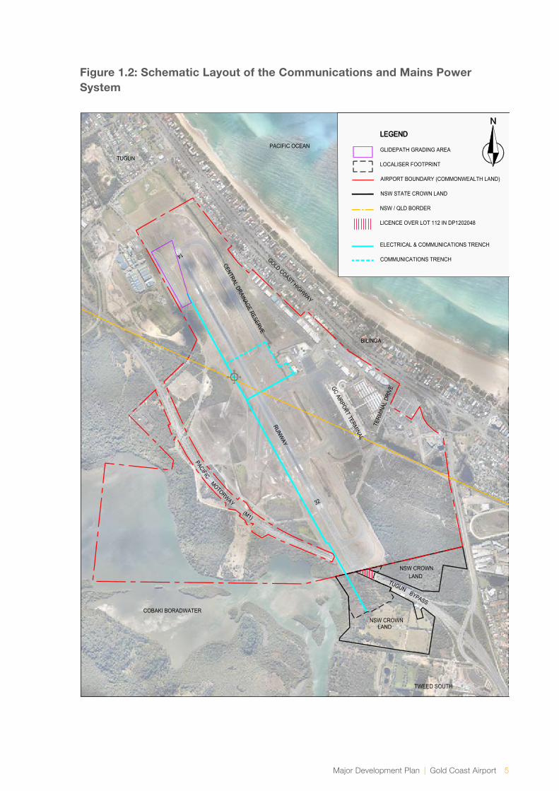
→ An in-ground communications and mains power system on both Commonwealth and New South Wales State land; and
→ The establishment of a new flight path to allow operation of the ILS. Details regarding the new flight path are further described in Section 1.4, Chapter 3 and Section 6.1.
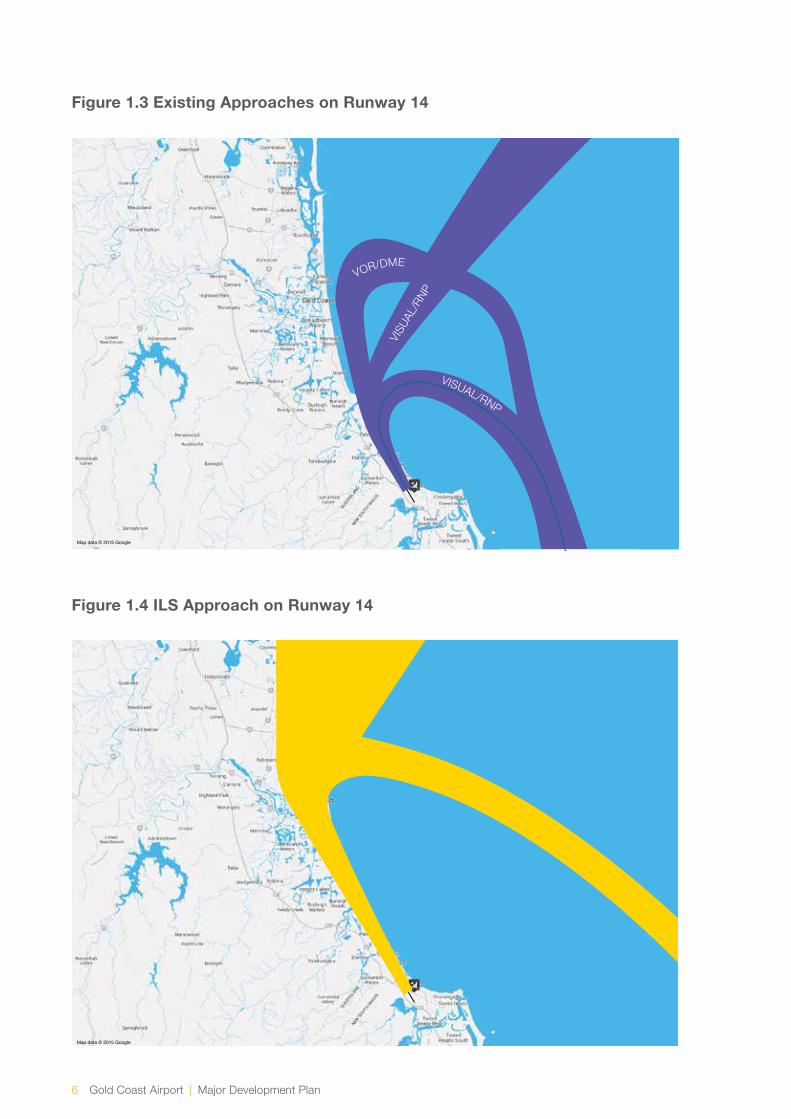
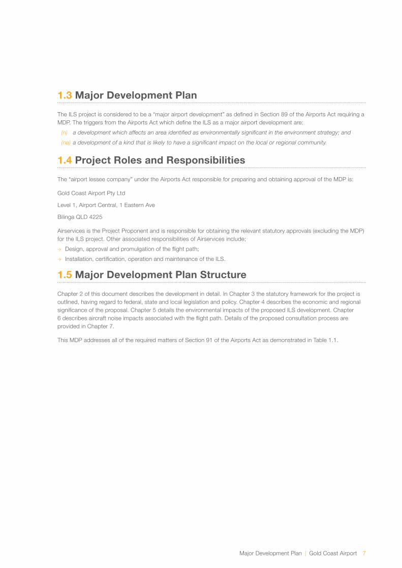
Figure 1.1 shows the location of the glidepath footprint, localiser footprint and runway strip widening, Figure 1.2 shows a schematic layout of the communications and mains power system for the ILS project and Figures 1.3 and 1.4 show existing flight paths and the ILS flight path on runway 14 respectively.
At Gold Coast Airport, runway 14 is used for landings from the north and runway 32 is used for landings from the south. The prevailing wind at Gold Coast Airport (from the south-east) results in runway 14 being the preferred runway for landings approximately two thirds of the time. It is therefore proposed to install the ILS on runway 14 due to operational benefits from the prevailing wind direction.
Currently aircraft landing at Gold Coast Airport are guided by non-precision approach procedures and the recently introduced satellite based landing system, Required Navigational Performance (RNP). Although RNP has improved the landing success rate on runway 14, an ILS will provide additional benefit allowing aircraft to land in all but the most severe weather conditions. This is represented in Figure 2.9. It is noted that the ILS approach procedure does not replace the existing approaches but creates a new approach. It is further noted that the proposed ILS has no effect on departure flight paths from Gold Coast airport.
The ILS project consists of three separate approval processes;
→ Works on Commonwealth Airport land under the Airports Act 1996 (Airports Act),
→ Works on NSW State land under the Air Services Act 1995 (Air Services Act), and
→ Approval of the ILS flight path under the Air Services Act and Civil Aviation Act 1988.
1.0 Introduction

Major Development Plan | Gold Coast Airport 3
While these three elements of the project have separate formal regulatory approval pathways, for simplicity, a single public consultation process was undertaken. This occurred through the Major Development Plan (MDP) process as regulated by the Airports Act. All feedback received during this consultation period was captured and considered as appropriate for each regulatory approval pathway. Section 7 of this MDP provides further detail on the consultation process.
The ILS project is considered to be a “major airport development” as defined in Section 89 of the Airports Act requiring a MDP due to the reasons noted in Section 1.3. In developing a MDP, airports must publish a preliminary draft MDP and invite public comment for a period of 60 business days. A draft MDP and a supplementary report has been prepared and submitted to the Minister for Infrastructure and Regional Development for approval of the components of the project located on Commonwealth airport land only.
Works on NSW state land are subject to a separate regulatory process managed by Airservices under Section 19 of the Air Services Act. As Airservices is a Commonwealth Agency, these works are also captured by the EPBC Act which relates to impacts on the whole of the environment, including matters protected under state and/or local legislation.
Prior to the MDP public comment period, a referral under Section 68 of the Environment Protection and Biodiversity Conservation Act 1999 (EPBC Act) was lodged by Airservices for the Commonwealth airport land and NSW State land component of the ILS project to determine whether or not the works were deemed a controlled action. The Commonwealth Department of Environment (DoE) determined the works on NSW State land are not a controlled action and no approvals under the EPBC Act are required. In addition, the Department of Infrastructure and Regional Development (DIRD) referred the exposure draft MDP to DoE under Section 160 of the EPBC Act as required and DoE has decided that the works on Commonwealth airport land are unlikely to have a significant impact on the environment and therefore, advice from the Minister for the Environment is not required.
The formal regulatory approvals for the flight path and noise impact are dependent on the MDP being approved, and will follow an additional regulatory process under Section 160 of the EPBC Act and the Air Services Act. Comments received during the public comment period
relating to the flight path have been considered by Airservices as part of the flight path approval process. Comments relating to the ground works on NSW State land received during the MDP public consultation process have been considered and addressed accordingly. Consideration of all comments received is detailed the supplementary report and where appropriate via amendments to the MDP.
A diagram depicting the key steps and interconnections between the MDP approval process and separate approval processes undertaken by Airservices is found in Figure 3.1.
Subject to approval of the MDP by the Minister for Infrastructure and Regional Development, it is anticipated that the ILS will be operational within a 12 month period. This assumes no delays due to wet weather, procurement and provision of construction, installation and commissioning services. Based on an MDP approval of January 2016 it is expected the ILS will be operational in January 2017.
1.2 Project Location
The location of the glidepath footprint, localiser footprint and widening of the runway strip to 300m along with state, property, lease and license boundaries are depicted in Figure 1.1. The widening of the runway strip from 150 metres to 300 metres and the glidepath footprint of the ILS are located on the Commonwealth leased airport land. The localiser component of ILS is located on both New South Wales State land (Lot 1 DP 1092951) leased to GCAPL and New South Wales Transport, Roads and Maritime Services land (Lot 112 DP 1202048) licenced to GCAPL. The communications and power system for the ILS project is located on both Commonwealth Land and New South Wales State land (Lot 1 DP 1092951).
For clarity, the New South Wales State land (leased to GCAPL) and New South Wales Transport, Roads and Maritime Services land (licensed to GCAPL) are referred to in this document as NSW State land.

4 Gold Coast Airport | Major Development Plan
Figure 1.1: Location of Glidepath Footprint, Localiser Footprint and Runway Strip Widening
LEGEND
WIDENING FOR 300m WIDE STRIP
ILS INFRASTRUCTURE
AIRPORT BOUNDARY (COMMONWEALTH LANDLEASED TO (GCAPL)
NSW STATE CROWN LAND(LEASED TO GCAPL, LOT 1 IN DP 1092951)
NSW / QLD BORDER
LICENCE OVER LOT 112 IN DP1202048
PACIFIC OCEAN
TUGUN
BILINGA
TWEED SOUTH
COBAKI BORADWATER
GOLD COAST HIGHWAY
(M1)
RUNWAY
CENTRAL DRAINAGE RESERVE
GC AIRPORT TERMINAL
MOTORWAY
PACIFIC
NSW CROWNLAND
TUGUNBYPASS
TERM
INAL
DRI
VE
32
14
NSW CROWNLAND
Major Development Plan | Gold Coast Airport 5
Figure 1.2: Schematic Layout of the Communications and Mains Power System
LEGENDLEGEND
GLIDEPATH GRADING AREA
LOCALISER FOOTPRINT
AIRPORT BOUNDARY (COMMONWEALTH LAND)
NSW STATE CROWN LAND
NSW / QLD BORDER
LICENCE OVER LOT 112 IN DP1202048
ELECTRICAL & COMMUNICATIONS TRENCH
COMMUNICATIONS TRENCH
PACIFIC OCEAN
TUGUN
BILINGA
TWEED SOUTH
COBAKI BORADWATER
GOLD COAST HIGHWAY
(M1)
RUNWAY
CENTRAL DRAINAGE RESERVE
GC AIRPORT TERMINAL
MOTORWAY
PACIFIC
NSW CROWNLAND
TUGUNBYPASS
TERM
INAL
DRI
VE
32
14
NSW CROWNLAND
6 Gold Coast Airport | Major Development Plan
Figure 1.3 Existing Approaches on Runway 14
Figure 1.4 ILS Approach on Runway 14
Map data © 2015 Google
Map data © 2015 Google
VOR/DME
VISU
AL/R
NP
VISUAL/RNP
Major Development Plan | Gold Coast Airport 7
1.3 Major Development Plan
The ILS project is considered to be a “major airport development” as defined in Section 89 of the Airports Act requiring a MDP. The triggers from the Airports Act which define the ILS as a major airport development are:
(n) adevelopmentwhichaffectsanareaidentifiedasenvironmentallysignificantintheenvironmentstrategy;and
(na) adevelopmentofakindthatislikelytohaveasignificantimpactonthelocalorregionalcommunity.
1.4 Project Roles and Responsibilities
The “airport lessee company” under the Airports Act responsible for preparing and obtaining approval of the MDP is:
Gold Coast Airport Pty Ltd
Level 1, Airport Central, 1 Eastern Ave
Bilinga QLD 4225
Airservices is the Project Proponent and is responsible for obtaining the relevant statutory approvals (excluding the MDP) for the ILS project. Other associated responsibilities of Airservices include;
→ Design, approval and promulgation of the flight path;
→ Installation, certification, operation and maintenance of the ILS.
1.5 Major Development Plan Structure
Chapter 2 of this document describes the development in detail. In Chapter 3 the statutory framework for the project is outlined, having regard to federal, state and local legislation and policy. Chapter 4 describes the economic and regional significance of the proposal. Chapter 5 details the environmental impacts of the proposed ILS development. Chapter 6 describes aircraft noise impacts associated with the flight path. Details of the proposed consultation process are provided in Chapter 7.
This MDP addresses all of the required matters of Section 91 of the Airports Act as demonstrated in Table 1.1.

8 Gold Coast Airport | Major Development Plan
Act Ref Major Development Plan RequirementSection of this MDP Matter is Addressed
91(1A) The purpose of a major development plan in relation to an airport is to establish the details of a major airport development that:
(a) relates to the airport
(b) is consistent with the airport lease for the airport and the final Master Plan for the airport
3.3
3.3 and 3.4
91(1)(a) The proponents objectives for the development 2.2
91(1)(b) The extent to which the development will meet the future needs of civil aviation uses of the Airport and other users of the Airport
2.4
91(1)(c) A detailed outline of the development 2
91(1)(ca) Whether or not the development is consistent with the Airport’s lease for the airport
3.3
91(1)(d) Whether or not the development is consistent with the final Master Plan for Gold Coast Airport
3.4
91(1)(e) If the development could affect noise exposure levels at the airport and the effect the development would have on noise exposure levels
6.2
91(1)(ea) If the development could affect flight paths at the airport— the effect that the development would be likely to have on those flight paths
6.1
91(1)(f) The airport-lessee company’s plans, developed following consultations with the airlines that use the airport, local government bodies in the vicinity of the airport; and
6.3
91(1)(g) An outline of the approvals that the proponent has sought, is seeking or proposes to seek under Division 5 or Part 12 in respect of elements of the development
3.6
Table 1.1: Major Development Plan Requirements

Major Development Plan | Gold Coast Airport 9
91(1)(ga) The likely affect the development would have on:
Traffic flows at the airport and surrounding the airport
Employment levels at the airport
The local and regional economy and community, including an analysis of how the developments fit within the local planning schemes for commercial and retail development in the adjacent area
2.8.4
4
N/A the proposal is not for a commercial or retail development
91(1)(h) An assessment of environmental impacts that might reasonably be expected to be associated with the development
5
91(1)(j) The proponents plans for ameliorating or preventing identified environmental impacts
5
91(1)(k) If the plan relates to a sensitive development—the exceptional circumstances that the airport lessee company claims will justify the development of the sensitive development at the airport
N/A the proposal is not for a sensitive
development
91(1)(l) Such other matters (if any) as are specified in the regulations N/A
91(4) The proponents plan must demonstrate the extent of the consistency with planning schemes in force under a law of the state where the Airport is location; and identity and justify any inconsistencies
3
91(6) In developing plans referred to in paragraph (l)(f), an airport lessee company must have regard to Australian Standard AS 2021—2000 (“Acoustics—Aircraft noise intrusion—Building siting and construction”) as in force or existing at that time
6.2

The Development2.0

12 Gold Coast Airport | Major Development Plan
2.1 Instrument Landing System
2.1.1 Description of ILS Components
An ILS is a precision, radio navigation, ground based aid comprising of two antennae. One antenna is located adjacent to the aircraft touchdown point of the runway (glidepath footprint) and the other located off the end of the runway (localiser footprint). The glidepath and localiser are described as follows:
→ The glidepath antenna is located adjacent to runway 14 (directly opposite the touchdown location), approximately 340 metres from the start of the runway. The glidepath antenna emits two UHF beams to a distance of 10 nautical miles. The UHF beams provide a lower and upper range of slope upon which the aircraft is to track to enable it to land at the required touchdown location on the runway.
→ The localiser antenna is located on the extended runway centreline approximately 300 metres beyond the southern runway end. It emits a VHF beam to a distance of 25 nautical miles that aligns the aircraft to the centreline of the runway commencing from a distance between 8 and 12 nautical miles from the start of the runway.
→ An in ground communications and mains power supply system for the glidepath and localiser installations as shown in Figure 1.2.
In addition to the glidepath and localiser installations the following components of the ILS are required;
→ The establishment of a 300 metre wide runway strip required by the Civil Aviation Safety Authority (CASA) for a Code 4E precision approach runway. Code 4E is a classification that applies to runway length and aircraft size. The current runway classification is Code 4E non-precision.
→ The establishment of a new flight path to allow operation of the ILS. Existing landing approaches and the ILS approach are shown in Figures 1.3 and 1.4 respectively. Further details regarding the new flight path are described in Chapter 3 and Chapter 6.
Typical localiser and glidepath installations are shown in Figures 2.1 and 2.2. Figure 2.4 shows the location of the glidepath and localiser installations at Gold Coast Airport. Section 2.1.3 discusses the site installation in more detail.
2.0 The Development

Major Development Plan | Gold Coast Airport 13
Figure 2.1: Typical Localiser Installation
Figure 2.2: Typical Glidepath Installation
14 Gold Coast Airport | Major Development Plan
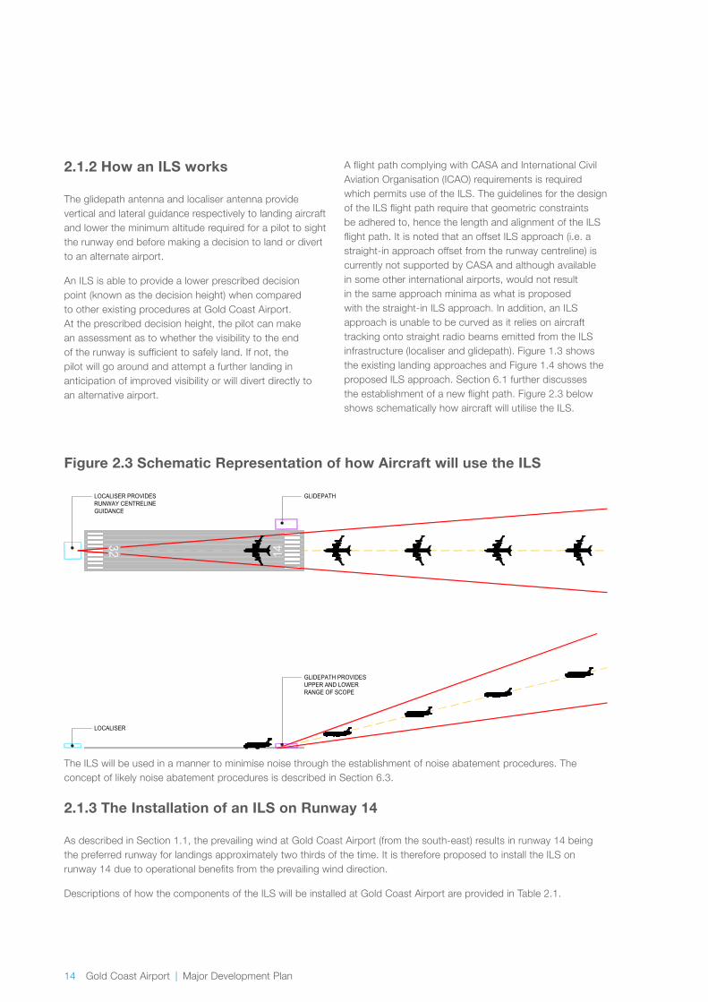
2.1.2 How an ILS works
The glidepath antenna and localiser antenna provide vertical and lateral guidance respectively to landing aircraft and lower the minimum altitude required for a pilot to sight the runway end before making a decision to land or divert to an alternate airport.
An ILS is able to provide a lower prescribed decision point (known as the decision height) when compared to other existing procedures at Gold Coast Airport. At the prescribed decision height, the pilot can make an assessment as to whether the visibility to the end of the runway is sufficient to safely land. If not, the pilot will go around and attempt a further landing in anticipation of improved visibility or will divert directly to an alternative airport.
A flight path complying with CASA and International Civil Aviation Organisation (ICAO) requirements is required which permits use of the ILS. The guidelines for the design of the ILS flight path require that geometric constraints be adhered to, hence the length and alignment of the ILS flight path. It is noted that an offset ILS approach (i.e. a straight-in approach offset from the runway centreline) is currently not supported by CASA and although available in some other international airports, would not result in the same approach minima as what is proposed with the straight-in ILS approach. In addition, an ILS approach is unable to be curved as it relies on aircraft tracking onto straight radio beams emitted from the ILS infrastructure (localiser and glidepath). Figure 1.3 shows the existing landing approaches and Figure 1.4 shows the proposed ILS approach. Section 6.1 further discusses the establishment of a new flight path. Figure 2.3 below shows schematically how aircraft will utilise the ILS.
Figure 2.3 Schematic Representation of how Aircraft will use the ILS
GLIDEPATH PROVIDESUPPER AND LOWERRANGE OF SCOPE
LOCALISER
LOCALISER PROVIDESRUNWAY CENTRELINEGUIDANCE
GLIDEPATH
32 14
The ILS will be used in a manner to minimise noise through the establishment of noise abatement procedures. The concept of likely noise abatement procedures is described in Section 6.3.
2.1.3 The Installation of an ILS on Runway 14
As described in Section 1.1, the prevailing wind at Gold Coast Airport (from the south-east) results in runway 14 being the preferred runway for landings approximately two thirds of the time. It is therefore proposed to install the ILS on runway 14 due to operational benefits from the prevailing wind direction.
Descriptions of how the components of the ILS will be installed at Gold Coast Airport are provided in Table 2.1.
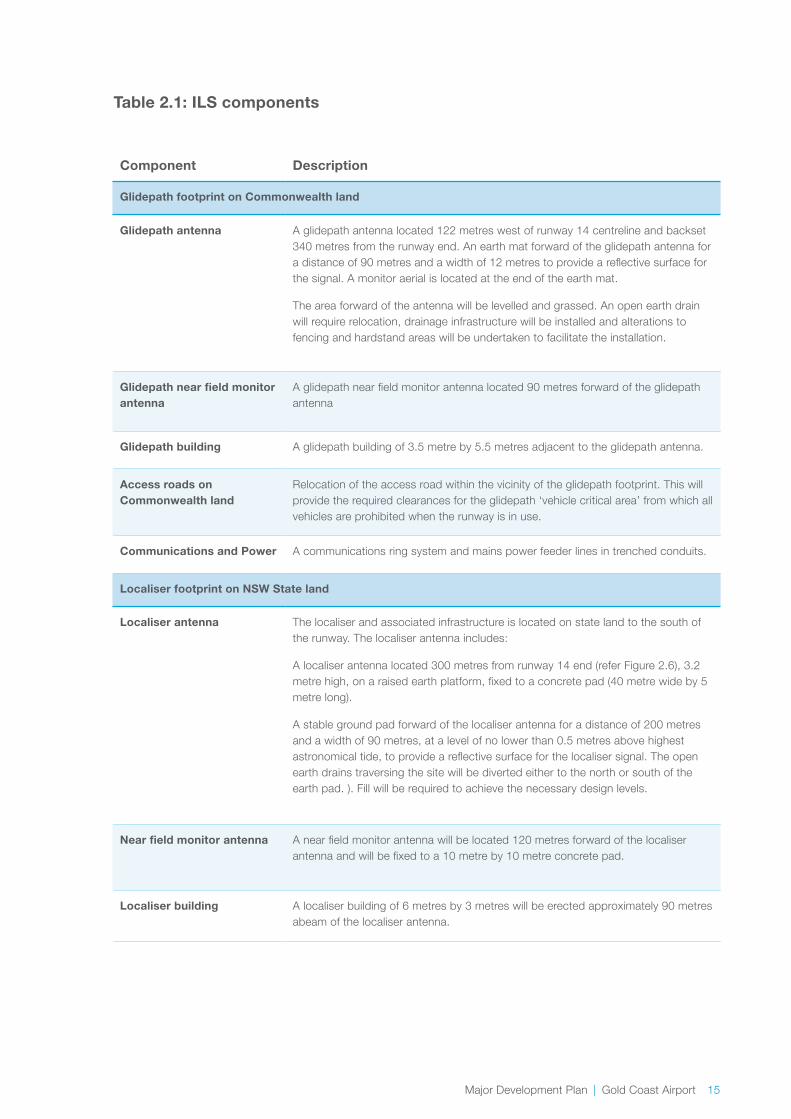
Major Development Plan | Gold Coast Airport 15
Component Description
Glidepath footprint on Commonwealth land
Glidepath antenna A glidepath antenna located 122 metres west of runway 14 centreline and backset 340 metres from the runway end. An earth mat forward of the glidepath antenna for a distance of 90 metres and a width of 12 metres to provide a reflective surface for the signal. A monitor aerial is located at the end of the earth mat.
The area forward of the antenna will be levelled and grassed. An open earth drain will require relocation, drainage infrastructure will be installed and alterations to fencing and hardstand areas will be undertaken to facilitate the installation.
Glidepath near field monitor antenna
A glidepath near field monitor antenna located 90 metres forward of the glidepath antenna
Glidepath building A glidepath building of 3.5 metre by 5.5 metres adjacent to the glidepath antenna.
Access roads on Commonwealth land
Relocation of the access road within the vicinity of the glidepath footprint. This will provide the required clearances for the glidepath ‘vehicle critical area’ from which all vehicles are prohibited when the runway is in use.
Communications and Power A communications ring system and mains power feeder lines in trenched conduits.
Localiser footprint on NSW State land
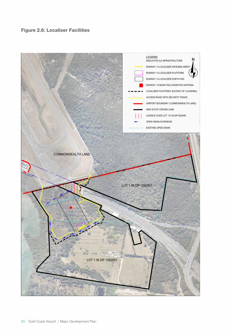
Localiser antenna The localiser and associated infrastructure is located on state land to the south of the runway. The localiser antenna includes:
A localiser antenna located 300 metres from runway 14 end (refer Figure 2.6), 3.2 metre high, on a raised earth platform, fixed to a concrete pad (40 metre wide by 5 metre long).
A stable ground pad forward of the localiser antenna for a distance of 200 metres and a width of 90 metres, at a level of no lower than 0.5 metres above highest astronomical tide, to provide a reflective surface for the localiser signal. The open earth drains traversing the site will be diverted either to the north or south of the earth pad. ). Fill will be required to achieve the necessary design levels.
Near field monitor antenna A near field monitor antenna will be located 120 metres forward of the localiser antenna and will be fixed to a 10 metre by 10 metre concrete pad.
Localiser building A localiser building of 6 metres by 3 metres will be erected approximately 90 metres abeam of the localiser antenna.
Table 2.1: ILS components

16 Gold Coast Airport | Major Development Plan
Access roads on state land An access road approximately 4 metres wide will be constructed within New South Wales state land to provide access to the localiser building and associated facilities. Fill will be required to achieve the necessary design levels.
The area in front (i.e. towards to end of the runway) of the localiser antenna, to 45 metres both sides of the runway centreline and 200 metres forward of the localiser antenna is defined as the localiser vehicle critical area from which all vehicles are prohibited when the runway is in use. The access road will be located adjacent to the perimeter fence for security patrol.
Perimeter fence A perimeter fence will be erected to the airport security standard.
Communications and Power A communications ring system and mains power feeder lines in trenched conduits.
300 metre wide runway strip widening on Commonwealth land
300 metre wide runway strip widening
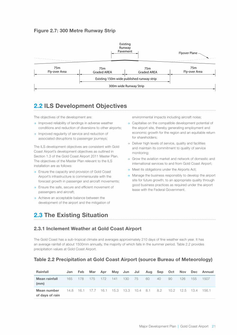
The ILS project will establish the 300 metre wide runway strip required by CASA) for a Code 4E precision approach runway. The current published width of the Gold Coast Airport’s runway strip is 150 metres. Management of the vegetation within the runway strip is required to ensure compliance to CASA standards. Figure 2.7 shows a cross-sectional representation of the 300 metre runway strip. The required 300 metre wide strip terminates 60 metres beyond each of the runway ends and comprises:
A 75 metre wide graded area either side of the centre line of the runway; and
A further 75 metre flyover area either side of the graded area. Within the flyover area, the ground surface and any object on it must not project above a plane surface, originating from the outer edge of the graded area, and sloping upwards and outwards, at a gradient of 5 percent (flyover plane).
Communications and Power A communications ring system and mains power feeder lines in trenched conduits.

Major Development Plan | Gold Coast Airport 17
2.1.4 Land Tenure for the ILS
The glidepath infrastructure, 300 metre wide strip widening and associated ground works are to be located on Commonwealth airport land comprising of:
→ Lot 5 DP 1186727 Commonwealth land, within the airport boundary, leased to GCAPL;
→ Lot 1 RP 225692 Commonwealth land, within the airport boundary, leased to GCAPL;
→ Lot 222 RP 839951 Commonwealth land, within the airport boundary, leased to GCAPL.
The localiser infrastructure and associated ground works are to be located on NSW State land comprising of:
→ Lot 1 DP 1092951 NSW State land which is leased to GCAPL on a long term lease commensurate with the lease on Commonwealth land.
→ Lot 112 DP 1202048 New South Wales Transport, Roads and Maritime Services land which is licenced to GCAPL.
Airservices is currently in the process of securing a sublease/licence for relevant components of the ILS project footprint from GCAPL who is the Airport-Lessee company for Gold Coast Airport and holds the head lease over New South Wales State Land Lot 1 DP1092051.
The location of the ILS and associated components are depicted in Figure 2.4. More detailed layouts of the glidepath footprint and localiser footprint are depicted in Figures 2.5 and 2.6 respectively.

18 Gold Coast Airport | Major Development Plan
Figure 2.4: Location of Runway 14 ILS and Associated Components
LEGENDLEGENDINDICATIVE ILS INFRASTRUCTURE
GLIDEPATH ANTENNA, EARTH MAT &MONITOR ARRAY
LOCALISER ANTENNA
GLIDEPATH GRADING AREA
LOCALISER FOOTPRINT
WIDENING FOR 300m WIDE RUNWAY STRIP
AIRPORT BOUNDARY (COMMONWEALTH LAND)
NSW STATE CROWN LAND
NSW / QLD BORDER
LICENCE OVER LOT 112 IN DP1202048
SYDNEY
NEWCASTLE
FRASERISLAND
COFFS HARBOUR
BALINAYAMBA
BYRON BAY
MAROOCHYDORE
TWEED HEADSGOLD COAST
BRISBANE
CHARLEVILLE
WARWICK
CASINO
TAMWORTH
PACIFIC OCEAN
TUGUN
BILINGA
TWEED SOUTH
COBAKI BORADWATER
GOLD COAST HIGHWAY
(M1)
RUNWAY
CENTRAL DRAINAGE RESERVE
GC AIRPORT TERMINAL
MOTORWAY
PACIFIC
NSW CROWNLAND
TUGUNBYPASS
TERM
INAL
DRI
VE
3214
NSW CROWNLAND

Major Development Plan | Gold Coast Airport 19
LEGENDINDICATIVE ILS INFRASTRUCTURE
RUNWAY 14 NEAR FIELDMONITOR ARRAY
RWY 14 GLIDEPATHANTENNA ARRAY
RUNWAY 14 GLIDEPATH EARTH MAT
RUNWAY 14 GLIDEPATH GRADING AREA
GLIDEPATH BUILDING
AIRPORT BOUNDARY(COMMONWEALTH LAND LEASED TO (GCAPL)
ACCESS ROAD WITH SECURITY FENCE
EXISTING AIRSIDE FENCE TO BE REMOVED
TUGUNGOLD COAST HIGHWAY
14
GLIDEPATHANTENNA ARRAY
NEAR FIELDMONITOR ARRAY
CENTRAL DRAINAGE RESERVE
Figure 2.5: Glidepath Facilities
20 Gold Coast Airport | Major Development Plan
Figure 2.6: Localiser Facilities
LEGENDINDICATIVE ILS INFRASTRUCTURE
RUNWAY 14 LOCALISER ANTENNA ARRAY
RUNWAY 14 LOCALISER PLATFORM
RUNWAY 14 LOCALISER EARTH PAD
RUNWAY 14 NEAR FIELD MONITOR ANTENNA
LOCALISER FOOTPRINT (EXTENT OF CLEARING)
ACCESS ROAD WITH SECURITY FENCE
AIRPORT BOUNDARY (COMMONWEALTH LAND)
NSW STATE CROWN LAND
LICENCE OVER LOT 112 IN DP1202048
OPEN DRAIN DIVERSION
EXISTING OPEN DRAIN
LOT 1 IN DP 1092951
LOT 1 IN DP 1092951
COMMONWEALTH LAND
Major Development Plan | Gold Coast Airport 21
Figure 2.7: 300 Metre Runway Strip
75mGraded AREA
75m Fly-over Area
300m wide Runway Strip
Existing 150m wide published runway strip
ExistingRunway
Pavement
75mGraded AREA
75m Fly-over Area
Flyover Plane
2.2 ILS Development Objectives
The objectives of the development are:
→ Improved reliability of landings in adverse weather conditions and reduction of diversions to other airports;
→ Improved regularity of service and reduction of associated disruptions to passenger journeys;
The ILS development objectives are consistent with Gold Coast Airport’s development objectives as outlined in Section 1.3 of the Gold Coast Airport 2011 Master Plan. The objectives of the Master Plan relevant to the ILS installation are as follows:
→ Ensure the capacity and provision of Gold Coast Airport’s infrastructure is commensurate with the forecast growth in passenger and aircraft movements;
→ Ensure the safe, secure and efficient movement of passengers and aircraft;
→ Achieve an acceptable balance between the development of the airport and the mitigation of
environmental impacts including aircraft noise;
→ Capitalise on the compatible development potential of the airport site, thereby generating employment and economic growth for the region and an equitable return for shareholders;
→ Deliver high levels of service, quality and facilities and maintain its commitment to quality of service monitoring;
→ Grow the aviation market and network of domestic and international services to and from Gold Coast Airport;
→ Meet its obligations under the Airports Act;
→ Manage the business responsibly to develop the airport site for future growth; to an appropriate quality through good business practices as required under the airport lease with the Federal Government.
2.3 The Existing Situation
2.3.1 Inclement Weather at Gold Coast Airport
The Gold Coast has a sub-tropical climate and averages approximately 210 days of fine weather each year. It has an average rainfall of about 1500mm annually, the majority of which falls in the summer period. Table 2.2 provides precipitation values at Gold Coast Airport.
Table 2.2 Precipitation at Gold Coast Airport (source Bureau of Meteorology)
Rainfall Jan Feb Mar Apr May Jun Jul Aug Sep Oct Nov Dec Annual
Mean rainfall (mm)
165 178 175 172 141 130 75 60 40 90 126 155 1507
Mean number of days of rain
14.8 16.1 17.7 16.1 15.3 13.3 10.4 8.1 8.2 10.2 12.5 13.4 156.1

22 Gold Coast Airport | Major Development Plan
Typical summer weather (December, January and February) consists of warm to hot days with tropical storms. Humidity is highest during this period of the year. During autumn (March, April and May) rainfall is high and average temperatures are milder than the summer months. In winter (June, July and August) the climate is generally sunny and dry with relatively stable conditions. Spring (September, October and November) experiences similar conditions to autumn.
Historic data indicates that weather conditions below existing approach procedure minima (minimum altitude at which the runway end is visible to the pilots) prevail for an estimated 1.3 percent of the time at Gold Coast Airport.
2.3.2 Inclement Weather Capability at Gold Coast Airport
Weather conditions below the approach procedure minima as described in Section 2.3.1, are responsible for a significant number of aircraft conducting a missed approach and/or diverting to other airports, predominantly Brisbane Airport.
These diversions and missed approaches arise from the relatively high visibility requirements associated with the current non-precision instrument approach procedures used at Gold Coast Airport. The resultant diversions to alternative airports cause significant disruption to passengers, meters and greeters, airlines and transport operators and places additional pressure on both the Brisbane and Gold Coast Air Traffic Control systems.
Gold Coast Airport receives approximately 35,000 arriving flights per year (comprising 20,000 regular public transport flights and 15,000 general aviation flights). Since October 2010, when GCAPL commenced recording, an average of 50 diversions per year (or approximately 10,000 passengers per year) from Gold Coast Airport to alternative airports has been recorded. The average number of diversions per month is depicted in Figure 2.8.
Figure 2.8: Average Diversions by Month
0
2
4
6
8
10
12
14Diversions
DecNovOctSepAugJulJunMayAprMarFebJan
Whilst the percentage of diversions in terms of total landings is relatively low, their distribution is concentrated to the wetter months of the year (as shown in Figure 2.8) resulting in significant disruptions to air transport providers and associated stakeholders.
In addition to the stated diversions, missed approaches occur in adverse weather conditions. These missed approaches result in additional fuel burn and increased noise to those under the existing approach and departure flight paths. In many instances these missed approaches result in a diversion to another airport, usually Brisbane Airport.
Another possible impact from missed approaches and diversions is the increased likelihood of flight cancellations. For example, departing flights from Sydney may be cancelled due to weather conditions at Gold Coast Airport and the unlikely success of a landing without an ILS.
In the event that a flight is diverted to Brisbane, the additional time and inconvenience for the traveller needs to be considered. This consists of the additional flight time to Brisbane, the additional journey by car, bus or train, arranging for associated transfers and returning back to their desired destination on the Gold Coast (in many cases a two hour addition to the traveller’s journey) . When put in the context of an original one hour flight from Sydney to Gold Coast, this diversion results in significant inconvenience. These same inconveniences may also translate to flight cancellations.

Major Development Plan | Gold Coast Airport 23
In 2012 GCAPL installed High Intensity Runway Edge Lighting (HIRL) to improve visibility during periods of inclement weather at a cost of $0.8 million. This HIRL is part of a group of works (including the ILS) that will significantly improve the likelihood of successful landings. Other proposals such as High Intensity Approach Lighting (HIAL) are also being considered for future works and will be the subject of a separate approval process.
2.3.3 How do Aircraft at Gold Coast Airport Currently Land
At Gold Coast Airport, runway 14 is used for landings from the north and runway 32 is used for landings from the south. The prevailing wind at the Airport results in runway 14 being the preferred runway for landings, meaning that it is used approximately 66% of the time (240 days per year). Runway 14 is constrained by terrain to the north of the airport which restrict further improvements in decision heights for each of the approaches described below.
The existing landing approaches and the ILS approach are depicted in Figures 1.3 and 1.4 respectively. Further details on the flight path are provided in Section 6.1.
Currently aircraft at Gold Coast Airport land via:
→ Visual approach procedures,
→ Non-precision approach procedures (VOR/DME - VHF Omni-directional Range/Distance Measuring Equipment),
→ RNP (Required Navigational Performance) procedures.
Values of decision height and visibility for VOR/DME, RNP and proposed ILS procedures are described in Table 2.3. VOR/DME and RNP procedures are described further in the text after Table 2.3.
Table 2.3: VOR/DME, RNP and ILS Approach Procedures
RUNWAY 14 RUNWAY 32
Decision Height (feet) Visibility (metres) Decision Height (feet) Visibility (metres)
VOR/DME 800 4000 750 4000
RNP (public) 500 approx 2400 *265 approx *1300
ILS 280 1500
*RNP procedures on runway 32 yet to be designed
NOTE: Decision heights are distance above sea level.

24 Gold Coast Airport | Major Development Plan
VOR/DME
A VOR/DME (as shown in Figure 1.3 as “VOR/DME”) is a non-precision navigation aid located on an airport that emits omni-directional radio signals. An aircraft landing, navigates to a pre-determined point, then flies on a prescribed track towards the runway to a decision height where the pilot assesses whether or not there is sufficient visibility of the runway end to attempt a landing. If not then the pilot will either attempt a further landing or divert to an alternative airport. For a non-precision landing on runway 14 at Gold Coast Airport the radio signal provides a track of 150 degrees from 10 nautical miles over the ocean until two (2) nautical miles from the runway end where the aircraft crosses the coast to attempt to land.
Required Navigational Performance (RNP)
Required Navigational Performance is a satellite based landing system. An aircraft landing using RNP navigates to a pre-determined point and is then guided by satellite signals along a prescribed track, towards the runway to a decision height where the pilot assesses whether or not there is sufficient visibility of the runway end to attempt a landing. If not then the pilot will either attempt a further landing or divert to an alternative airport. For a RNP landing on runway 14 at Gold Coast Airport the satellite signals will provide a series of tracks over the ocean crossing the coast at 2 nautical miles from the runway end to attempt to land.
Figure 2.9 Landing Approaches on Runway 14
Future RNP procedures on runway 32 will complement the ILS system on runway 14 by providing a lower decision height for runway 32 as indicated in Table 2.3 above.
RNP procedures at Gold Coast Airport are available on runway 14 to all airlines who are RNP approved through aircraft capability and pilot endorsement. It is anticipated that RNP procedures on runway 32 will be available in early 2016.
The data in Table 2.3 shows how an ILS approach on runway 14 achieves a significant improvement to decision height and visibility when compared to an RNP approach and a VOR/DME approach. This is also depicted in Figure 2.9 below.
It is further noted that future RNP procedures on runway 32 achieve a similar level of service to an ILS on runway 14. An ILS on runway 32 will not be able to provide significant further improvement in decision height or visibility to the future RNP procedure, therefore, when comparing the benefit of an ILS installation on runway 14 to runway 32, an installation on runway 14 achieves a greater benefit.

Major Development Plan | Gold Coast Airport 25
2.4 Future Needs of Aircraft Users
Tourism is a major industry which generates a large number of visitors to the region. Based on data from Tourism Research Australia, there were over 12.5 million visitors to south east Queensland and northern New South Wales regions in the year to September 2014. This comprised of 7,722,500 (61 percent) domestic day visitors, 4,008,000 (32 percent) domestic overnight visitors and 828,000 (7 percent) international visitors.
Twenty year aviation traffic activity forecasts have been developed as part of the Gold Coast Airport 2011 Master Plan. The forecasts indicate a growth in the number of arriving and departing passengers per annum from 6 million in 2011 to 16.3 million in 2031 and a growth in aircraft movements per annum from 39,276 in 2011 to 82,660 in 2031.
With south east Queensland and northern New South Wales tourist destinations attracting more visitors annually, when this forecast in growth is realised, the number of diversions will increase proportionally if the existing landing minima is not improved.
By improving the success rate of landings in adverse weather, the ILS will have a direct positive impact on the future operating capacity of Gold Coast Airport. The installation of an ILS will improve airline’s confidence in using Gold Coast Airport and the future needs of airport users will be appropriately met.
2.5 Why an ILS
Weather conditions are responsible for a significant number of aircraft conducting a missed approach and/or diverting to other airports, predominantly Brisbane Airport. The resultant diversions to alternative airports cause significant disruptions and economic loss.
The existing non-precision navigation aids used at Gold Coast Airport have limitations with respect to their use in adverse weather conditions and low visibility. The recently introduced RNP procedures have improved landing minima, however, not to the extent of a precision navigational aid such as an ILS. Since the introduction of RNP, there have still been a number of diversions (December 2014 to May 2015). Some of these diversions involved aircraft that are not RNP capable. However, the number of diversions for both RNP and non-RNP capable aircraft may have reduced further if an ILS with the expected lower minima was available. An ILS is therefore the preferred navigational aid due to its reliability, widespread use and proven success.
Other landing systems such as a Ground Based Augmentation System (GBAS) are expected to provide minima similar to an ILS. However, as the technology for these systems is relatively new, they are not expected to be widely adopted for a number of years. Sydney Airport is the only airport in the Southern Hemisphere with GBAS. It is further understood that if GBAS were installed at Gold Coast Airport, a straight in approach (similar to ILS) would be required in order to achieve the ILS landing minima. Although a curved approach that achieves the same landing minima as an ILS may be possible with GBAS in the future, it is not currently available and is not likely to be available for a number of years. In the future if other systems such as GBAS are implemented, the ILS is expected to be maintained as a separate, alternate landing aid.
Further benefits of an ILS are described in Section 2.8.1.
26 Gold Coast Airport | Major Development Plan
2.6 When the ILS will be used
The ILS will be able to be used at any time at the discretion of the pilot.
Aircraft arriving from southern destinations that are RNP approved and capable, would normally elect to fly the shorter RNP approaches in preference to the ILS to save on time and reduce the route travelled.
When arriving from northern destinations, it is expected that pilots will choose to use either RNP or the ILS during poor and deteriorating weather conditions in preference to the existing VOR/DME approach procedures as these procedures are not aligned with the runway and are workload intensive to pilots.
There will be occasions when the ILS is used outside of inclement weather. All non-Australian/New Zealand international heavy jets (i.e. A330/B787 aircraft) will be required to complete an instrument approach and for this reason may choose the ILS over the existing approach procedures. Subject to operational capacity, the ILS will also be available for training and for pilots to maintain currency of licensing during daylight hours.
2.7 How much the ILS will be used
An environmental assessment was undertaken by Airservices to identify affected communities and determine the likely noise impact associated with the new flight path The usage assumptions presented in this MDP reflect those used in the environmental assessment.
In twelve months of arrival flight data (2012/13), the highest recorded number of arriving flights in one day has been 82. The noise impact assessment described in Chapter 6 has assumed this number of flights.
The current average number of arriving RPT (Regular Public Transport) flights at Gold Coast Airport is 55 per day and the majority of these flights (approximately 50) are from the south.
As described previously, the ILS will be used most frequently in times of bad weather, however there will be occasions when the ILS is used in fine weather as described above in Section 2.6.
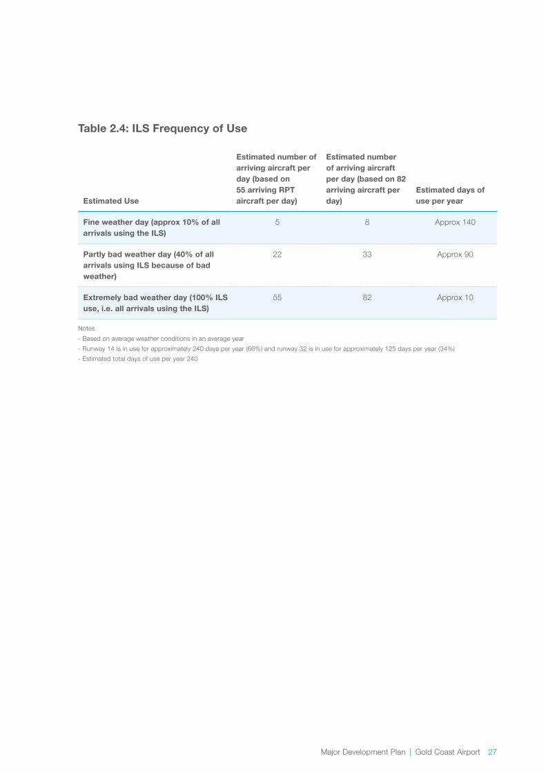
Table 2.4 describes the estimated frequency of usage of the ILS based on the average number of arriving RPT flights per day (55), the highest recorded number of arriving flights per day (82) and a usage of runway 14 for approximately 240 days (66%) of the year. As can be seen from the data in Table 2.4 and based on the highest recorded number of arriving flights in one day, the ILS could be used up to 82 times per day on an extremely bad weather day (up to 10 days per year). On a fine weather day (approximately 140 days per year) the ILS would be used less frequently (up to 8 times per day).
Major Development Plan | Gold Coast Airport 27
Table 2.4: ILS Frequency of Use
Estimated Use
Estimated number of arriving aircraft per day (based on 55 arriving RPT aircraft per day)
Estimated number of arriving aircraft per day (based on 82 arriving aircraft per day)
Estimated days of use per year
Fine weather day (approx 10% of all arrivals using the ILS)
5 8 Approx 140
Partly bad weather day (40% of all arrivals using ILS because of bad weather)
22 33 Approx 90
Extremely bad weather day (100% ILS use, i.e. all arrivals using the ILS)
55 82 Approx 10
Notes
- Based on average weather conditions in an average year
- Runway 14 is in use for approximately 240 days per year (66%) and runway 32 is in use for approximately 125 days per year (34%)
- Estimated total days of use per year 240

28 Gold Coast Airport | Major Development Plan
2.8 Outcome of Installing the ILS on Runway 14
The 2011 Gold Coast Airport Master Plan outlined air traffic forecasts predicted at Gold Coast Airport. These forecasts are not expected to change as a result of the ILS installation as the master plan made allowance for an ILS. There will however be an increase in the number of aircraft that can land in inclement weather.
2.8.1 Benefits of an ILS
All users of the airport will benefit from a landing system capable of minimising the number of missed approaches and diversions. Many airport users operate businesses at the airport from retailing through to ground transport services and government agencies. These users are all economically and operationally adversely impacted when an aircraft is diverted to another airport, particularly when the aircraft does not complete its services through to the Gold Coast Airport. Family and friends of passengers diverted to other airports are particularly inconvenienced.
Some of the benefits realised as a result of the ILS installation include:
→ Reduction in the frequency of diversions to other airports (currently around 50 diversions per year from Gold Coast Airport to alternative airports have been recorded since October 2010 largely due to adverse weather conditions);
→ Reduction in associated disruptions to passenger journeys;
→ Improved customer experience;
→ Equipping Gold Coast Airport with the same level of technology as other airports of a similar size and capacity; and
→ Reduce the alternate minima which will reduce the frequency for the carrying of additional fuel (refer description in 2.8.2).
2.8.2 Regular Public Transport (RPT)
The installation of an ILS will result in improved reliability for RPT aircraft landings at Gold Coast Airport during periods of inclement weather. This will provide a greater level of certainty in planning for forecasted weather conditions. An ILS is capable of being used by all RPT aircraft and will benefit all RPT operators.
One of the benefits of an ILS is the reduction of alternate minima. Alternate minima is a term used to describe the triggers which determine when an aircraft should carry additional fuel. When planning a flight, meteorological conditions and forecasts are considered. When conditions are forecast to be less than the nominated alternate minima, the pilot is to make provision for an alternative course of action and is to carry additional fuel. Currently these conditions are forecast to occur on average 30 percent of the control tower operating hours (note that the control tower operates during non-curfew hours from 0600 to 2300). The reduction of alternate minima does not apply to all operators. Only airlines with CASA approved to apply a special alternate minima will be able to use a lower minima.
The installation of an ILS will improve the current alternate minima for CASA approved operators at Gold Coast Airport and in doing so will reduce the amount of fuel required to be carried by these airlines during certain forecasted weather conditions, consequently reducing aircraft weight and fuel burn. Such a reduction in fuel use is a significant benefit to these airlines in reducing their cost of fuel which is a large part of an airlines operating costs.
Major Development Plan | Gold Coast Airport 29
2.8.3 Benefits to General Aviation
General Aviation is the sector of the aviation industry that does not carry out RPT operations and includes a range of aircraft types operating out of Gold Coast Airport from light aircraft, helicopters, turbo prop aircraft through to jet aircraft. Turbo prop and jet aircraft generally have the required instrumentation and pilot capability to use an ILS and will therefore realise the same benefits as RPT aircraft.
Training aircraft fitted with appropriate instrumentation are likely to use the ILS to undertake practice approaches to gain familiarity. The estimated ILS usage in Table 2.4 includes an allowance for these approaches.
2.8.4 Vehicular Traffic Impacts
Construction traffic associated with the works includes the delivery of materials and equipment and vehicle movements associated with a construction workforce. The construction workforce for the NSW State land area of the project will access the site via Parkes Drive and park within the site. For areas within the Commonwealth Airport Lease, construction workforce will primarily enter through Terminal Drive and Tower Rd. Due to the relatively minor scale of works required to construct the ILS project, impacts to traffic flows at the airport and surrounding the airport associated with construction are anticipated to be minor.
During operation, the ILS project will have no traffic impacts to traffic flows at the airport and surrounding the airport. The infrastructure is located away from external pedestrian and vehicular traffic areas and the ILS project will require minimal maintenance to be undertaken by Airservices.

Regulatory Framework
3.0

32 Gold Coast Airport | Major Development Plan
3.1 Introduction
This chapter provides details of the consistency of the project with relevant Commonwealth, State and local planning provisions.
In addition this chapter of the report details key legislation to be addressed as part of the proposal includes the following:
→ Airports Act 1996;
→ Airports Regulations 1997;
→ Airports (Environment Protection) Regulations 1997;
→ Airports (Building Control) Regulations 1996;
→ Airports (Control of On-Airport Activities) Regulations 1997;
→ Airport (Protection of Airspace) Regulations 1996;
→ Air Services Act 1995;
→ Environment Protection and Biodiversity Conservation Act 1999; and
→ Civil Aviation Act 1988.
3.2 Relevant Legislation
3.2.1 Airports Act 1996
Components of the ILS project situated on Commonwealth airport land are subject to the planning framework prescribed in the Airports Act. The Airports Act and associated Regulations are the statutory controls for ongoing regulation of activities on airport land for both aeronautical and non-aeronautical purposes. Part 5 of the Airports Act prescribes a number of controls over land use, planning and building at Commonwealth leased airports.
Under Part 5, Section 89 of the Airports Act a MDP is required for each major development at a Commonwealth leased airport. The project outlined in this MDP is defined as a ‘major airport development’ by virtue of Section 89:
(n)adevelopmentwhichaffectsanareaidentifiedasenvironmentallysignificantintheenvironmentstrategy; and
(na) a development of a kind that is likely to have a significantimpactonthelocalorregionalcommunity.
Although Airservices is the proponent of the project, Section 88 of the Airports Act requires MDP’s to be prepared by the airport-lessee company which is GCAPL for Gold Coast Airport.
Section 91 of the Airports Act specifies elements that are to be addressed in the preparation of a MDP. Table 1.1 of this MDP provides a reference guide to demonstrate how each legislative requirement has been addressed within this MDP.
In developing a MDP, airports must publish a preliminary draft MDP and invite public comment for a period of 60 business days. A draft MDP and a supplementary report has been prepared and submitted to the Minister for Infrastructure and Regional Development for approval.
This MDP includes information on all elements of the ILS project for the purposes of a single public consultation process. The MDP seeks approval under the Airports Act for works on Commonwealth land. Changes to flight paths and potential noise impacts are subject of separate approvals obtained by Airservices in parallel to the MDP process. The formal regulatory approvals for the flight path and noise impact are dependent on the MDP being approved, and will follow an additional regulatory process under Section 160 of the EPBC Act and the Air Services Act. Comments received during the MDP public comment period relating to the flight path have been considered by Airservices as part of the flight path approval process. The key steps in the approval process for an MDP under the Airports Act and the separate approvals obtained by Airservices in accordance with the Air Services Act are presented in Figure 3.1.
3.0 Regulatory Framework

Major Development Plan | Gold Coast Airport 33
Figure 3.1: ILS Approvals Process
NSW Crown Land
Airservices s68 EPBC referral for impacts on the whole of the environment for the Commonwealth and
NSW Crown Land ground works
Section 19 of the Air Services Act provides Airservices
with an exemption from the application of State and
Territory land use laws when carrying out its functions
Note. Airservices as a Commonwealth Agency is captured by Section 28 of
the EPBC Act which relates to impacts on the whole of the environment, including matters protected under
state and/or local legislation.
Airservices s161 EPBC referral of the environmental impacts
and mitigation measures of the new flight
Preparation of ILS Project preliminary draft MDP by GCAPL
New flight path impacts and mitigation measures detailed in the
MDP for public comment
Airservices update flight path assessment considering
comments received during public comment of the draft MDP
Airservices update flight path assessment considering
comments received during public comment of the draft MDP
Airservices update flight path assessment considering
comments received during public comment of the preliminary
draft MDP
Airservices refer updated flight path environmental assessment to DOE for advice under s160 of the
EPBC Act
DoE provide advice to Airservices/CASA
Following approval of the MDP, Airservices/CASA authorise flight paths considering DoE
advice where relevant
State and Local Authorities advised and preliminary draft MDP public consultation undertaken
Draft MDP updated and public consultation report prepared
considering comments received during public exhibition period
Draft MDP and public consultation report submitted to Minister for
consideration
Minister approves Draft MDP (with or without conditions), or Minister
refuses the MDP
MDP Approval Process
Commonwealth Airport Land New Flight Path
34 Gold Coast Airport | Major Development Plan
3.2.2 Environment Protection and Biodiversity Conservation Act 1999
As Gold Coast Airport is situated on Commonwealth land, it is subject to the provisions of the Commonwealth EPBC Act.
The EPBC Act is administered by DoE, and contains provisions in relation to environmental impact assessment of projects on Commonwealth land which may have a significant impact on the whole of the environment and on matters of national environmental significance.
Chapter 5 of this MDP outlines the potential impacts from the project on the whole of the environment and Matters of National Environmental Significance (MNES). The relevant MINES for this project are:
→ Listed threatened species and ecological communities;
→ Migratory species protected under the international agreements;
Chapter 5 of this MDP also assesses ground impacts on the whole of the environment, both within the Commonwealth airport land and NSW State land. The ground impacts are not considered to result in a significant impact on the environment.
A referral under Section 68 of the EPBC Act was lodged by Airservices for the Commonwealth airport land and NSW State land component of the ILS project to determine whether or not the works were deemed a controlled action. DoE determined the works on NSW State land are not a controlled action and no approvals under the EPBC Act are required. In addition, DoE has advised DIRD under Section 161A of the EPBC Act that the action on Commonwealth airport land is unlikely to have a significant impact on the environment and that advice from the Minister for the Environment is not required.
Chapter 6 of this MDP outlines the potential noise impact arising from the new flight paths on the community. Airservices, as the designer of the flight path, has undertaken an environmental assessment of the flight paths for the ILS in accordance with its obligations under the Air Services Act and the EPBC Act.
The formal regulatory approvals for the flight path and noise impact are dependent on the MDP being approved, and will follow an additional regulatory process under Section 160 of the EPBC Act and the Air Services Act. Comments received during the MDP public comment period relating to the flight path will be considered by Airservices as part of the flight path approval process.
3.2.3 The Air Services Act 1995 (Cth)
The Air Services Act establishes Airservices as a Commonwealth corporation with functions and powers relating to aviation and related purposes. Under Part 171 of the Civil Aviation Safety Regulations 1998 (Cth) Airservices is the only organisation (aside from the Department of Defence) that is authorised to commission and maintain the ILS.
Airservices is the proponent for the ILS project. Section 19 of the Air Services Act provides Airservices with an exemption from the application of state and territory land use laws when carrying out its functions. Section 19 of the Air Services Act will be relied upon by Airservices to manage any land use zoning restrictions or regulations that may otherwise apply on NSW State land where the localiser antenna array and associated infrastructure are to be installed.
Although exempt from these legislative instruments, the ILS installation will still be subject to relevant Commonwealth legislation, including the EPBC Act which considers the whole of environment including state and local significance. The assessment of on ground environmental impact from the ILS on NSW State land is detailed in Chapter 5.
Approvals associated with the changes to flight paths and associated noise impacts will be undertaken by Airservices in accordance with the Air Services Act, if the MDP is approved.

Major Development Plan | Gold Coast Airport 35
Airservices have prepared a preliminary draft design of a new flight path for the ILS and will be developing associated ILS operating procedures, including noise abatement procedures. In designing the flight path and the operating procedures, Airservices has assessed the environmental impact of the new flight path and determined the impact of the noise from the new flight path to the community is considered to be significant. The potential noise impact arising from the new flight path on the community and proposed noise abatement procedures are discussed within Chapter 6 of this MDP.
3.2.4 Civil Aviation Act 1988
Under the Civil Aviation Act 1988, CASA is the government-owned authority responsible for the regulation of civil aviation safety. The ILS will be installed, commissioned, operated and maintained in accordance with regulations administered by CASA.
3.3 Consistency with the Airport Lease
Section 91(1A)(b) of the Airports Act 1996 requires that a major development is consistent with the airport lease for the airport.
The airport lease for Gold Coast Airport requires that GCAPL develops Gold Coast Airport, having regard to anticipated future growth in, and pattern of, traffic demand to a standard reasonably expected of such an airport and to “good business practice,” which amongst other matters requires GCAPL to provide facilities for the expeditious movement of passengers and other users. The provision of the ILS is consistent with the airport lease by providing a facility that improves the movement of passengers and aircraft catering for anticipated future growth.
3.4 Consistency with Gold Coast Airport Master Plan
3.4.1 General
The regulation of land use on the airport is achieved via the Master Plan prepared in accordance with the Airports Act and approved in May 2012 by the Federal Minister for Infrastructure and Regional Development. The Master Plan is subject to review every 5 years to ensure the plan meets the airports and communities requirements.
The Master Plan reflects the GCAPL land use strategy and considers the surrounding local and state government planning objectives. This strategic document details development for the 20 year horizon to the year 2031 and includes a 20 year development plan, as well as one for the immediate 5 year period. All development works at GCA are required to be undertaken in accordance with the Master Plan.
Section 10.5 of the 2011 Master Plan identifies that GCAPL has “....requested Airservices to investigate the benefits of installing an ILS.... ” and “... as a result of this request, Airservices has committed to the installation of an ILS to improve landing capability in marginal weather conditions. Any introduction of ILS will still be subject to technical assessment, industry acceptance and significant community consultation prior to implementation.”
The preliminary flight path design as described in Section 6.1 of this MDP is consistent with the indicative flight paths for the ILS as shown in Figure 12.8 of the 2011 Master Plan.
The Master Plan also contains assessment of potential environmental impacts and mitigation measures associated with the implementation of the plan along with an environment strategy, which provides the framework for environmental management at the airport. The environment strategy addressed matters such as identification of environmentally significant areas (ESAs), sources of environmental impact and mitigation measures, environmental legislative requirements and promotes continual improvement. The MDP demonstrates consistency with the environmental strategy described in the Master Plan.

36 Gold Coast Airport | Major Development Plan
3.4.2 Land Use in the Master Plan
The regulation of land use on the airport is achieved via the Master Plan which was prepared in accordance with the Airports Act and approved in May 2012 by the Federal Minister for Infrastructure and Regional Development.
The Master Plan reflects the Gold Coast Airport land use strategy and considers the surrounding local and state government planning objectives. This strategic document details development for the 20 year horizon to the year 2031 and includes a 20 year development plan, as well as one for the immediate 5 year period. All development works at GCA are required to be undertaken in accordance with the Master Plan.
The Master Plan identifies five precincts as described below:
→ Runway Precinct;
→ Terminal Precinct;
→ General Aviation Precinct;
→ Western Enterprise Precinct;
→ Cobaki Environment Precinct.
The widening of the runway strip from 150 metres to 300 metres and the ILS infrastructure are within the “Runway Precinct” of the Master Plan, as shown in Figure 3.2. The current and intended key development objectives for the runway precinct relevant to this project are:
→ Safe aircraft landing, take off and taxiing operations;
→ Aircraft navigation aids, radar and communications equipment; air traffic control, aviation rescue and firefighting and meteorological services;
→ Other facilities to ensure safe operation of aircraft.
The runway strip widening from 150 metres to 300 metres and the ILS installation is therefore a compatible land use with the runway precinct as nominated in the Master Plan.
The Master Plan does not cover the component of the ILS infrastructure located on NSW State land.
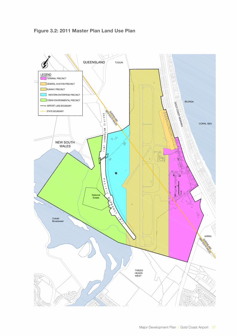
Major Development Plan | Gold Coast Airport 37
Figure 3.2: 2011 Master Plan Land Use Plan
LEGENDTERMINAL PRECINCT
GENERAL AVIATION PRECINCT
RUNWAY PRECINCT
WESTERN ENTERPRISE PRECINCT
COBAKI ENVIRONMENTAL PRECINCT
AIRPORT LAND BOUNDARY
STATE BOUNDARY
TWEEDHEADSWEST
CobakiBroadwater
NationalEstate
PA
CI
FI
C
MO
TO
RW
AY
(
M1
)
PA
CI F
I C M
OT
OR
WA
Y
(M1
)
BILINGA
KIRRA
TUGUNG
OLD
CO
AST HIG
HW
AY CORAL SEAQUEENSLAND
NEW SOUTH WALES
QUEENSLAND
NEW SOUTH WALES
QUEENSLAND
NEW SOUTHWALES
u:\pr-projects\pr103 - gca 2011 masterplan\#fig6.1 pr103sk005-b mp-2011 landuse plan.dwg2011 Land Use Plan. Figure 6.1

38 Gold Coast Airport | Major Development Plan
3.5 Consistency with Statutory Documents
A MDP must detail the extent of consistency with state and local government planning schemes in force where the airport is located. State and local legislation has been reviewed as part of the preparation of this MDP.
Gold Coast Airport straddles the state border and lies partly in New South Wales and partly in Queensland. The airport’s vital role in the regional economy is acknowledged by regional and state planning documents on both sides of the border. Due to its location, the Airport lies partly in Tweed Shire and partly in Gold Coast City. Again the Airport’s importance in the regional economy and the regional transport network is acknowledged in the strategic planning documents of both local government authorities. In each case the Airport property is included in special use zones in recognition of the presence of the airport.
3.5.1 State Planning Legislation
Queensland
The state significance of the Gold Coast Airport is acknowledged by the Queensland Government through the State Planning Policy (SPP) and the South East Queensland Regional Plan.
State Planning Policy
Gold Coast Airport is classified as a Strategic Airport under the SPP, and is thus protected by, and subject to, the provisions of the policy, in terms of local authority planning.
The SPP sets out the state interest concerning strategic airports and aviation facilities considered essential for the state’s transport infrastructure and playing a key role in facilitating economic growth in Queensland.
The SPP provides direction for local governments preparing planning schemes to appropriately identify strategic airports and to facilitate development surrounding these airports, and includes a code with which local authority planning schemes are required to be consistent, and very comprehensive guidance material concerning strategic airports and aviation facilities for the assistance of local government.
The SPP applies to off airport developments that could:
i. Encroach into the operational airspace of a strategic airport;
ii. Encroach into the building restricted area of an aviation facility;
iii. Increase the number of people that could work or live in areas affected by aircraft noise;
iv. Increase the number of people or lead to the presence of dangerous materials within the public safety area; or
v. Involve other potential hazards to aircraft operating in the airport’s airspace.
As required, the draft Gold Coast City Plan 2015 reflects the provisions of the SPP by inclusion of a comprehensive airport code with the following overlays:
→ Australian noise exposure forecast contours;
→ Bird and bat strike zone;
→ Light Intensity;
→ Obstacle limitation surface;
→ PANS-OPS; and
→ Public safety area.
South East Queensland Regional Plan 2009 - 2031
The South East Queensland Regional Plan recognises that the Gold Coast Airport provides for economic and employment diversification on the Gold Coast and facilitates the growth of tourism, manufacturing, logistics, and freight distribution. The Regional Plan supports the Airport in terms of economic and employment growth, and supports the protection of the Airport from incompatible development.
The Airport is recognised as a key element of the region’s transport system servicing the regional population and business/industry.
Major Development Plan | Gold Coast Airport 39
New South Wales
Far North Coast Regional Strategy
The Far North Coast Regional Strategy (the Strategy) applies to the six local government areas of Ballina, Byron, Kyogle, Lismore, Richmond Valley and Tweed, and is one of a number of regional strategies that have been prepared by the New South Wales Department of Planning and Environment. The Strategy’s purpose is to manage the region’s expected high growth rate in a sustainable manner and to protect the unique environmental assets, cultural values and natural resources of the region while ensuring that future planning maintains the character of the region and provides for economic opportunities.
The Strategy identified a number of planning objectives, these are:
→ Environmental (protecting land with environmental, agricultural, vegetation, habitat, waterway, wetland or coastline values);
→ Population and housing (managing population and providing a variety of housing);
→ Economic (strengthen economic activity by promoting sectors in infrastructure, transport, and construction).
The project is in keeping with these aims.
3.6 Consistency with Local Planning Regimes
3.6.1 Land Use and Zoning in Tweed Shire
Located directly south of the Airport is the NSW State land leased to GCAPL. The works under the Air Services Act that consist of a localiser antenna, new access road, security fencing, vegetation clearing, and enabling works are all located on the NSW State land. Those works are outside this MDP application.
Lot 1 DP 1092051 is generally undeveloped with partial use by the Tweed Heads Pony Club. The licensed area over Lot 112 is located over the Tugun Bypass tunnel. South of the Pony Club, there is a large vacant parcel zoned industrial, for which an industrial subdivision was approved around 2004, but has not yet proceeded. Adjoining to the west of that property, and directly beyond and in line with the runway centreline, is the Tweed Shire Council sewage treatment plant and depot. Adjoining on Parkes Drive is the recently approved Masters Hardware development.
Regulation of land use and development within the Tweed Shire (New South Wales) is achieved via the Tweed Local Environmental Plan 2014 (LEP 2014) that reflects the state government planning objectives as set out in the Environmental Planning and Assessment Act 1979 and is consistent with the statewide standard instrument LEP.
The key aim of the LEP 2014 is to “encourage a sustainable local economy and small business, employment, agriculture, affordable housing, recreational, arts, social, cultural, tourism and sustainable industry opportunities appropriate to Tweed”.
To a large extent, zoning of land surrounding the Airport within the Tweed Shire is reflective of the current land use pattern. However, adjacent to the Airport to the south and west, the land is classified as “Deferred Matter”, in which there is no specified zoning. For these areas, the previous zones in the superseded LEP 2000 will continue to apply, for most of the affected land, this is due to deferral by the state government of former Environmental Protection Zones, although in the case of the NSW State land leased by GCAPL immediately south of the airport, it is so as to not preclude development of aeronautical facilities. The NSW State land leased by GCAPL is the area where the localiser footprint is proposed.
The airport is zoned Special Purposes - SP1 Airport. The key objective of the SP1 zone is to “provide for special land uses that are not provided for in other zones”. Although the airport land use is not regulated by the LEP 2014, the zoning does nevertheless specifically designate the airport as the intended usage.
The LEP contains zonings and overlays that reflect the nature of existing land uses and impacts from the Airport, both in its current and proposed form, have on the surrounding land. The ILS project is consistent with the intent of the LEP 2014 and will not impact on zoning at and in the vicinity of the Airport.

40 Gold Coast Airport | Major Development Plan
3.6.2 City of Gold Coast Land Use and Zoning
Located to the north-west of the Airport is the Tugun Commercial and Domestic Waste Land Fill and Desalination plant and the Betty Diamond Sporting Complex.
Regulation of planning and land use within the City of Gold Coast (Queensland) is currently under the Gold Coast Planning Scheme 2003. However the council’s new planning scheme, City Plan 2015, is at an advanced stage of preparation and expected to be in place prior to commencement of the project. Therefore, the following description is based on the forthcoming new planning scheme, rather than the current, effectively superseded one.
The Airport is zoned “Special Purpose” under City Plan 2015, which relates to activities regulated by other legislation (in this case, the Commonwealth Airports Act), or otherwise not subject to planning and development control under the local planning scheme.
The City Plan 2015 identifies the Airport as providing key transport infrastructure that will contribute to developing Gold Coast as a world-class city. In addition, the City Plan 2015 envisages growth in airport support services and tourist accommodation in close proximity to the Airport to further advance economic productivity and prosperity.
A specific outcome of the City Plan 2015 is that existing or planned noise-sensitive uses surrounding the Airport manage aircraft noise through appropriate design and location of new development, including appropriate noise mitigation techniques. A comprehensive Overlay Code is included in the City Plan dealing with all relevant airport and aircraft-related topics, including avoidance of adverse impacts of aircraft noise, protection against intrusions into the Airport’s airspace in the form of buildings or otherwise, as well as other potential effects on pilots of aircraft operating in the airspace. The Code is modelled on the mandatory requirements of the SPP.
The project will have no impacts on zoning at and in the vicinity of the Airport and will not result in a change to the existing Australian Noise Exposure Forecast (ANEF) Contours, Bird and Bat Strike Zone, Light intensity, Obstacle Limitation Surface (OLS), and Public safety areas that impact the surrounding land use. In addition, the Airport Environs - ANEF contour overlay within the City Plan 2015 has taken in to account the 2031 ANEF of the 2011 Master Plan that includes an ILS.
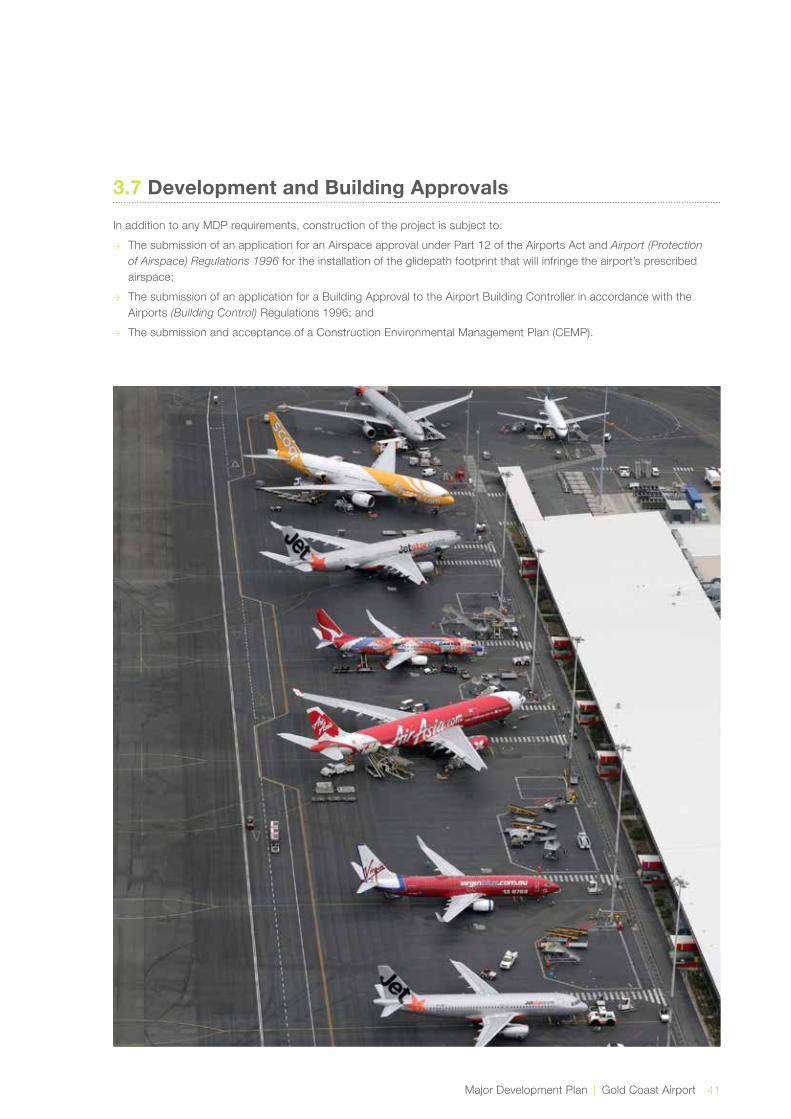
Major Development Plan | Gold Coast Airport 41
3.7 Development and Building Approvals
In addition to any MDP requirements, construction of the project is subject to:
→ The submission of an application for an Airspace approval under Part 12 of the Airports Act and Airport (Protection of Airspace) Regulations 1996 for the installation of the glidepath footprint that will infringe the airport’s prescribed airspace;
→ The submission of an application for a Building Approval to the Airport Building Controller in accordance with the Airports (Building Control) Regulations 1996; and
→ The submission and acceptance of a Construction Environmental Management Plan (CEMP).

Economic & Regional Significance
4.0
44 Gold Coast Airport | Major Development Plan
4.1 Introduction
Gold Coast Airport is significant as an economic driver of the region, in terms of employment, direct and indirect economic impact and the facilitated impact arising from the flow on benefits of the visitor economy which includes tourism, education and major events. Gold Coast Airport is a significant infrastructure asset to both south east Queensland and northern New South Wales. The economic impact of Gold Coast Airport is expected to reach $368 million by 2016/17, having grown significantly from $269 million in 2009/10. This equates to an average growth rate of 4.6 percent per annum. Within the 5 year period up to 2016/17, employment levels at Gold Coast Airport are forecast to increase by 37 percent to 2,350 individuals in a full-time or part-time role at GCA, representing the equivalent of 1,803 full time roles. By 2016/2017 Gold Coast Airport will facilitate 2.61 million visitors to the region, which represents a 36 percent increase on 2010, or an additional 690,000 visitors over 2010, equating to an average annual growth rate of 4.5 percent.
Presently on average 50 flights per annum are diverted from Gold Coast Airport to alternative airports due to adverse weather conditions. This effects approximately 10,000 passengers annually with the majority of aircraft diverted to Brisbane Airport. This requires the aircraft to either disembark its passengers at Brisbane Airport or to return to Gold Coast Airport when the weather conditions improve. If passengers disembark at Brisbane Airport, then the airlines arrange for the passengers to be bussed to Gold Coast Airport in order to complete their journey and vice versa for departing passengers. Friends and families of passengers are similarly affected.
The impact on tourism resulting from the introduction of an ILS is expected to be overwhelmingly positive as it will result in greater certainty of landings and the future attraction of international carriers.
4.2 Economic – Immediate Benefits
For the airlines, where the majority of the losses occur, for each flight diverted, it is estimated an additional cost of $50,000 is incurred (or $2.5 million per annum) based on the current level of diversions. In addition to the above tangible costs, the level of inconvenience and disruption to the passenger is significant. It is estimated that installation of an ILS on one runway end, being runway 14 with maximum usability, would reduce the number of diversions and costs by approximately two thirds. The potential benefits are both immediate and long term.
The direct and immediate financial benefits to Gold Coast Airport and its associated aviation and business precinct would be an increase in income of approximately $100,000 per annum. This translates to an economic benefit to the local economy of approximately $88,000 per annum comprising a direct impact of $49,000 and a direct and induced impact of $39,000. These benefits would be realised immediately with the introduction of an ILS and would increase over time as passenger growth occurs. The construction phase of the ILS project is envisaged to have duration of up to 12 months. The works will involve vegetation clearing, general civil works and building works relating to the installation of antennae and site structures.
These activities will provide benefit to the local economy via employment in the areas of construction and engineering. During the operational phase, the ILS will be managed by the staff of Airservices Australia.
4.2.1 Economic – Long-Term
When a diverted aircraft does not return to the Gold Coast Airport, there are adverse financial impacts to businesses in a number of areas. GCAPL has loss of income from landing fees, terminal retailers have loss of income from retail spend, airlines have additional costs relating to bussing of passengers and increased fuel burn and aircraft usage to the airlines.
The ILS will improve the reliability of flights resulting in benefits to both airlines and passengers. The economic impact due to the loss of an existing service or the failure to attract an additional service due to relatively high number of diversions can be estimated when considering the value to the regional economy (south east Queensland/northern New South Wales) of each domestic and international service into the airport. The value to the regional economy by expenditure of a daily domestic service is $30 million per annum and a daily international service is $46 million per annum. If the risk of losing a service, or not attracting a new service is (say) 10 percent higher by the airport continuing to not have ILS capability, then the economic loss to the region is $3.0 million for a domestic service and 4.6 million for an international service per annum. Note the value of the daily international service ($46 million) is an average of all international services (including those to New Zealand).
International airlines particularly expect that an international airport such as Gold Coast Airport would have an ILS installed and is a significant factor in potential new international airlines deciding whether to fly to Gold Coast Airport, when Brisbane Airport, which has an ILS is of the same flying time. The most recent new international airline to fly direct to Gold Coast Airport was Scoot, in June 2012, with the Queensland Government estimating
4.0 Economic and Regional Significance
Major Development Plan | Gold Coast Airport 45
the economic value over the following 12 months, through visitor expenditure, at $100 million. Other Major international growth markets such as China, Indonesia and India are focus points of GCAPL’s business development program over the next 10 years. Securing direct air links from these and other international markets is the role that Gold Coast Airport plays in the economic development of the greater Gold Coast, south east Queensland and northern New South Wales regions.
The impact of the flight path on property values has been considered and two independent studies were completed. The studies investigated residential areas located outside of and under flight paths in various locations around Australia (including the Gold Coast) and assessed such things as the rate of capital appreciation and key market drivers. The results of the studies indicated that there is unlikely to be a detrimental impact on property values as a result of the ILS flight path.
4.3 Regional Significance
Gold Coast Airport is currently one of Australia’s fastest growing airports and forecast by the Bureau of Infrastructure, Transport and Regional Economics (BITRE) in 2013 to be one of the top two (2) fastest growing airports (alongside Perth) over the next 20 years. It is the fifth (5) busiest international airport in Australia and the sixth (6) busiest airport overall. It currently services 6 million passengers a year and is forecast to grow to 16.3 million passengers by 2031. It lies within one of the fastest growing areas in Australia being south east Queensland and northern New South Wales coastal strip.
Tourism and Events Queensland contributes to achieving the Federal Government’s objective to grow a four pillar economy and forms an integral part of the delivery of Government’s DestinationQ strategy. The strategy includes growth in the south east Queensland region with a vision to deliver tourism visitor expenditure in Queensland to $30 billion by 2020. Destination NSW also recognizes the important role played by Gold Coast Airport in that state’s achievement of 2020 goals. In the New South Wales Government’s Visitor Economy Taskforce (VET) document handed down by the New South Wales Minister for Tourism in January 2013 the government acknowledges that – “Gold Coast/Coolangatta Airport near the New South Wales/Queensland border currently plays a key role in servicing the aviation needs of rapidly growing south east Queensland. This airport’s strategic location, and its base load of aviation transport servicing the Gold Coast, provides an opportunity to provide easy access to visitors wishing to visit the northern regions of New South Wales”. This commitment by the New South Wales State Government to align their strategic growth in the north of the state with Gold Coast Airport highlights the expectation for access to expanding air services at the airport.
A landing approach supported by an ILS will make Gold
Coast Airport a more attractive airport in terms of aircraft approach options and support the growth of international airline markets to south east Queensland and northern New South Wales. Strategic planning documents in both Gold Coast and Tweed regions reflect that Gold Coast Airport is an integral piece of infrastructure for the region. The planning documents also identify the importance of the airport in providing employment and economic growth in the region.
The following example illustrates the region’s experience of the economic benefits that one new international airline can have on the south east Queensland and northern New South Wales region. Singaporean passenger carrier Scoot, represents the economic value and growth generated from one new international airline at Gold Coast Airport. It is estimated by the Department of Tourism, Major Events, Small Business and the Commonwealth Games that the new Scoot service to Gold Coast Airport has contributed to $100 million in visitor expenditure in a 12 month period from the inauguration of flights in June 2012.
The benefits that flow from international visitors is a clear indicator that Gold Coast Airport requires infrastructure that supports future growth opportunities from high yielding visitor markets across the Asia/Pacific region.
The regional benefit that derives from Gold Coast Airport’s passenger growth, both domestic and international is also reflected positively in growing visitor numbers to northern New South Wales particularly, in the Tweed region. Destination Tweed have experienced significant growth in visits by South African tourists, after their organisation moved to capitalise on the increased capacity of Scoot flying directly to Gold Coast Airport. Previously the route from South Africa to the region had no low cost carriers and Australia was priced out of the market for the average South African tourist. Now Australia is affordable and accessible via Scoot from Singapore and their gateway to Australia is direct to the Tweed region.
Furthermore, close working relationships forged by GCAPL with the New South Wales Government and with regional councils across the Northern Rivers of New South Wales have enhanced the access to major tourism destinations in the region such as Byron Bay. Tourism operators across all segments including accommodation, transport and events rely on access through Gold Coast Airport for driving visitor growth. The New South Wales Government has formally recognised Gold Coast Airport as the state’s second international gateway after Sydney. This nomination benefits the long term regional growth outlook in both northern New South Wales and south east Queensland region.


Environmental Assessment
5.0

48 Gold Coast Airport | Major Development Plan
5.1 Assessment Approach
This Chapter details the environmental assessment and mitigation measures for the ILS on-ground infrastructure and widening of the existing 150 metre runway strip to 300 metres, on Commonwealth airport land and on NSW State land. The ILS Project components are shown in Figure 2.4 and include:
→ The glidepath footprint (at the northern end of runway 14 on Commonwealth land);
→ 300 metre wide runway strip (150 metres either side of the runway centreline and extending 60 metres beyond the runway ends). The 300 metre runway strip is largely grassed but includes five patches of vegetation that form part of the airport’s Environmentally Significant Areas (ESA), described further below. These patches are referred to in this report as ESA Impact Areas A, B, C, D and E, (Figure 5.1).
→ The localiser footprint (at the southern end of runway 14 on NSW State land).
Trenching and under-boring for installation of power and communications infrastructure for the ILS will also occur as part of the project.
The above components of the project were referred to DoE by Airservices under Section 68 of the EPBC Act. DoE determined the works on NSW State land are not a controlled action and no approvals under the EPBC Act are required. In addition, DoE has advised DIRD under Section 161A of the EPBC Act that the action on Commonwealth airport land is unlikely to have a significant impact on the environment and that advice from the Minister for the Environment is not required. A minor amendment was made to the localiser footprint since the referral to DoE, which resulted in an increase of approximately 0.2ha to impacted vegetation communities in this area. This small increase does not change the outcome of the impact assessment and DoE have been provided details of the amendment.
As indicated in Chapter 1, the works in the localiser footprint that are outside the airport on NSW State land are not subject to the requirements of the Airports Act. These works are considered within this section to provide context with regard to the impacts of the project as a whole. The assessment of impacts in the localiser footprint has considered the impacts to Matters of National Environmental Significance (MNES) and the whole environment under the EPBC Act.
In accordance with the Airports Act, the environment strategy contained within the Gold Coast Airport Master Plan identifies ESAs at the airport. ESAs are shown in Figure 5.1. The method to determine environmental significance divided Gold Coast Airport into units of homogenous land use and vegetation communities. Each unit was then assessed based on:
→ Whether it was known habitat for legislatively significant species (both Commonwealth and State);
→ The legislative status of vegetation communities (both Commonwealth and State); and
→ The size, condition and connectivity of the vegetation community.
Developments at the airport that affect ESAs trigger the preparation of an MDP as described in Section 1.2 and 3.2.1.
The environmental assessment considers the following aspects:
→ Resource use;
→ Land, including:
» Soils
» Contaminated land
» Acid sulfate soils
→ Surface and groundwater;
→ Biodiversity, including:
» Habitat values and wildlife corridors; and
» Significant flora and fauna.
→ Cultural heritage;
→ Air and noise;
→ Hazardous materials.
The aspects and mitigation measures considered in this environmental assessment are generally consistent with the environment chapter of the Master Plan. The environment chapter of the Master Plan contains two components:
→ Environmental assessment and mitigation of potential environmental impacts associated with implementation of the Master Plan; and
→ Management of potential environmental impacts associated with operational elements of airport activities (the environment strategy).
5.0 Environmental Assessment

Major Development Plan | Gold Coast Airport 49
5.1.1 Review of Baseline Conditions
The baseline environmental assessment for the MDP included a desktop review of environmental information relevant to the ILS ground infrastructure (the study area) as well as two site surveys in the project footprint.
Desktop Review
The desktop study involved a review of GIS mapping as well as reports and literature relevant to fauna and flora values in the study area. This included the following sources:
→ ESA mapping for the airport;
→ Regional Ecosystem (RE) mapping from the Queensland Department of Environment and Heritage Protection;
→ Fauna Corridor Data from the New South Wales Office of Environment and Heritage;
→ Northern Rivers Vegetation Mapping from the New South Wales Office of Environment and Heritage (2010);
→ Directory of Important Wetlands mapping from the Australian Department of Environment and Heritage (2005);
→ The following species database searches:
» EPBC Act Protected Matters Search Tool for the study area, accessed 3 June 2014;
» DERM Wildlife Online database search, with a 1 square kilometre search area from the centre of the airport site (accessed 29 March 2013);
» Atlas of New South Wales Wildlife, with a default 10 square kilometre search area (accessed 29 March 2013).
→ Aerial photography;
→ Review of key ecology studies undertaken at the airport, including annual fauna monitoring and significant species mapping;
→ Other reports, literature and relevant airport management plans.
Site Survey
Two site surveys (14 March 2013 and 19 December 2013) were undertaken to verify mapped information reviewed during the desktop study. Both surveys:
→ Undertook a vegetation mapping verification and habitat assessment, taking notes of habitat characteristics, vegetation structure and floristics;
→ Recorded incidental observations of significant fauna.
A targeted aural frog survey was also undertaken on 14 March 2013 in the localiser footprint for Wallum Sedge Frog (Litoria olongburensis) and Wallum Froglet (Crinia tinnula) to supplement previous surveys undertaken in the area.
In addition to this, a habitat survey for Wallum Sedge Frog was undertaken within ESA Impact Area A within the 300 metre runway strip on 19 December 2013. The habitat assessment of ESA Impact Area A involved a walk-through of the area to identify areas of potentially suitable habitat for Wallum Sedge Frog along with transect surveys to identify floristics. The survey also included an aural survey, however conditions were considered sub-optimal as detailed in Section 5.6.2.
Both surveys were undertaken in line with the Draft Referral Guidelines for the Wallum Sedge Frog (SEWPaC 2011) as well as the Survey Guidelines for Australia’s Threatened Frogs (DEWHA 2010) as far as practical.
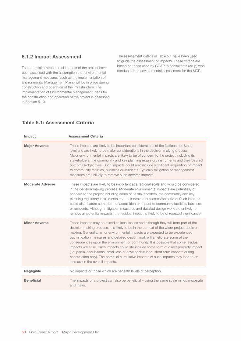
50 Gold Coast Airport | Major Development Plan
5.1.2 Impact Assessment
The potential environmental impacts of the project have been assessed with the assumption that environmental management measures (such as the implementation of Environmental Management Plans) will be in place during construction and operation of the infrastructure. The implementation of Environmental Management Plans for the construction and operation of the project is described in Section 5.10.
Table 5.1: Assessment Criteria
Impact Assessment Criteria
Major Adverse These impacts are likely to be important considerations at the National, or State level and are likely to be major considerations in the decision making process. Major environmental impacts are likely to be of concern to the project including its stakeholders, the community and key planning regulatory instruments and their desired outcomes/objectives. Such impacts could also include significant acquisition or impact to community facilities, business or residents. Typically mitigation or management measures are unlikely to remove such adverse impacts.
Moderate Adverse These impacts are likely to be important at a regional scale and would be considered in the decision making process. Moderate environmental impacts are potentially of concern to the project including some of its stakeholders, the community and key planning regulatory instruments and their desired outcomes/objectives. Such impacts could also feature some form of acquisition or impact to community facilities, business or residents. Although mitigation measures and detailed design work are unlikely to remove all potential impacts, the residual impact is likely to be of reduced significance.
Minor Adverse These impacts may be raised as local issues and although they will form part of the decision making process, it is likely to be in the context of the wider project decision making. Generally, minor environmental impacts are expected to be experienced but mitigation measures and detailed design work will ameliorate some of the consequences upon the environment or community. It is possible that some residual impacts will arise. Such impacts could still include some form of direct property impact (i.e. partial acquisitions, small loss of developable land, short term impacts during construction only). The potential cumulative impacts of such impacts may lead to an increase in the overall impacts.
Negligible No impacts or those which are beneath levels of perception.
Beneficial The impacts of a project can also be beneficial – using the same scale minor, moderate and major.
The assessment criteria in Table 5.1 have been used to guide the assessment of impacts. These criteria are based on those used by GCAPL’s consultants (Arup) who conducted the environmental assessment for the MDP.
Major Development Plan | Gold Coast Airport 51
The following EPBC Act guidelines have also been used to guide the assessment of impacts as they provide the Commonwealth framework for the assessment of the significance of impacts upon Matters of National Environmental Significance and the whole of the environment on Commonwealth land:
→ Significant Impact Guidelines 1.1 - Matters of National Environmental Significance,
→ Significant Impact Guidelines 1.2 - Actions on, or impacting upon, Commonwealth land and Actions by Commonwealth Agencies.
5.1.3 Terminology
The term ‘significant species’ collectively includes migratory and marine species listed under the EPBC Act as well as threatened species. It also includes species that may be considered of special significance (e.g. due to limited distribution) though are not protected under State or Commonwealth legislation. The term ‘threatened species’ includes:
→ Species listed under the EPBC Act as threatened;
→ Species listed as Extinct, Endangered, Vulnerable or Near Threatened under the Queensland Nature Conservation Act 1992 (NC Act); and/or
→ Species listed as Critically Endangered, Endangered or Vulnerable under the New South Wales Threatened Species Conservation Act 1995 (TSC Act).
The term “Threatened Ecological Communities” includes:
→ Ecological communities listed as threatened under the EPBC Act; and/or
→ Ecological communities listed as Critically Endangered, Endangered or Vulnerable under the TSC Act.
5.2 Resource Use
The construction and operation of the project will require resources in the form of materials and energy. Materials used during construction will include but not be limited to:
→ Concrete for foundations, slabs and paths;
→ Road base material and gravel;
→ Fill material;
→ Steel for antennae, building structures and fences;
→ Cabling for services; and
→ Concrete drainage pipes and culverts.
Energy will be required during construction and operation of the project.
The materials and energy required for the project are expected to result in a negligible impact to resources. The Construction Environmental Management Plan will identify opportunities for efficient use of materials and minimisation of waste.

52 Gold Coast Airport | Major Development Plan
5.3 Land
5.3.1 Baseline Conditions
Acid Sulfate Soils
The airport and surrounds are within a low-lying coastal area and, like much of the surrounding coastal land, there is a high likelihood that the glidepath footprint and 300 metre runway strip contain potential or actual acid sulfate soils.
Acid sulfate soil investigations undertaken as part of this project indicate that the localiser footprint comprises a thin layer of top soil over alluvial sands, extending to a depth of at least 5.5 – 6.0 metres below ground level. Net acidity concentrations above the action criteria within the Acid Sulfate Soils Assessment Guidelines (Stone et al. 1998) have been identified in some areas. Net acidity concentrations above the action criteria were reported at varying soil depths and for half of the samples analysed as part of the acid sulfate soil investigations. In some areas in particular, the top 200 millimetres of soil was considered to have relatively high levels of net acidity (net acidity was approximately five times the action criteria level).
Contaminated Land
A small number of contaminated sites are recorded on the airport, with one located within the glidepath footprint and the north-west section of the 300 metre runway strip, and another one to the west of the 300 metre runway strip, refer Figure 5.2.
A detailed stage 2 environmental site assessment was undertaken in 2007 for the portion of contaminated land within the glidepath footprint and north-west section of the 300 metre runway strip. The study notes that the area had been subject to historical filling activities associated with the Tugun Landfill and the Gold Coast Council sewerage treatment plant. The study found that the site contained various fill materials including nightsoil deposits, landfill wastes, asbestos fragments and general fill soils. The landfill waste was generally encountered at a depth of 0.5 metres below ground level and extended in some locations to a depth of approximately 2.5 metres below ground level. Soil samples collected at the site were analysed for a wide variety of potential contaminants however only two samples returned results marginally above the Airport (Environmental Protection) Regulations
1997 (AEPR) acceptance limits. All sample results were found to be below the National Environment Protection (Assessment of Site Contamination) Measure ‘Health-based Investigation Level F criteria’ for commercial and industrial land use and the AEPR Acceptance Limits for General Areas. Evidence collected during the study suggests that the landfill and sewerage materials were introduced to the site in the late 1960s.
The area of contaminated land to the west of the 300 metre runway strip is associated with the Airservices fire training area. The site contains contamination associated with constituents of previously used firefighting foam (Perflurooctane sulfonate (PFOS) and perfluorooctanoic acid (PFOA)) and hydrocarbon contaminants.
PFOS and PFOA form part of a group of man-made chemicals known as perfluorinated chemicals (PFCs) which have a range of applications, however are an emerging contaminant as they are known to accumulate to levels of concern in the environment. PFCs are also known to be present outside of the area west of the runway as mentioned above.
A search of the New South Wales Contaminated Land Register did not identify contaminated land in the localiser footprint.
5.3.2 Assessment of Impacts
Glidepath Footprint
In the glidepath, minor excavations are likely to occur for trenching for provision of services to the glidepath facilities and for relocation of the existing drainage line. Site works may result in the exposure of soil from the movement of heavy machinery over soft grassed surfaces, excavation and grubbing activities. The use of fill soils to grade the area may also expose soils. Once soil is exposed to wind and rain, it has the potential to erode (which reduces soil quality at the site) and generate dust and sedimentation issues in surrounding areas. With the implementation of appropriate dust, erosion and sediment control measures, the impacts to soils are expected to be negligible.
Excavations in the glidepath footprint may expose potential or actual acid sulfate soils. With appropriate management through the development and implementation of an Acid Sulfate Soils Management Plan, the associated impact to soils, groundwater and above ground ecology and drainage systems from acid sulfate soil is expected to be negligible.

Major Development Plan | Gold Coast Airport 53
Disturbance of contaminated land has the potential to result in adverse impacts to the surrounding environment including waterways, soils and wildlife, or to have human health impacts. Due to the minor nature of excavations in the glidepath footprint the disturbance to contaminated soils is expected to be minimal. This would be confirmed during detailed design, and a Contaminated Land Management Plan will be developed and implemented. With implementation of a management plan for occurrences of this nature, impacts are expected to be negligible.
300 metre Runway Strip
Vegetation will be trimmed in ESA Impact Areas B to E to a height between 1.5 and 2.0 metres above ground level to comply with CASA requirements and in ESA Impact Area A, all vegetation will require clearing as vegetation type, density and height makes trimming unviable. ESA Impact Area A will be cleared, graded, grassed and mown. Clearing will temporarily expose soils over an area of approximately 1.3 hectares, before grass establishes.
Selected removal of plants and clearing activities will result in the exposure of soil from the movement of heavy machinery over vegetated surfaces, excavation and grubbing activities. The use of fill to grade the area is also likely to result in soils being exposed. Once soil is exposed to wind and/or rain it has the potential to erode (which reduces soil quality at the site) and generates dust and sedimentation issues in surrounding areas. With the implementation of appropriate soil, dust, erosion and sediment control, the impacts to soils from erosion are expected to be negligible.
Trenching or under boring for installation of services in the 300 metre runway strip is unlikely to encounter contamination associated with the above mentioned fire training ground. However, as the extent of this contamination isn’t fully delineated further assessment will be undertaken prior to commencement of construction to identify if installation of services will disturb any contamination, and if so, a Contaminated Land Management Plan will be developed and implemented to manage potential impacts. The impacts from contaminated land are expected to be negligible.
Trenching or under boring for installation of services may encounter acid sulfate soils. An Acid Sulfate Soil Management Plan will be implemented during construction, if determined to be required in the detailed design phase. The impacts from acid sulfate soils to soils, groundwater and above ground ecology and drainage systems in the 300 metre runway strip is expected to be negligible.
Localiser Footprint
Works will result in the exposure of soil from the movement of heavy machinery over vegetated surfaces, excavation (e.g. trenching for provision of services to the localiser building and antenna array and realignment of drainage channels and grubbing activities. The use of fill soils to grade the area may also expose soils.
Erosion and sedimentation will be carefully managed, through the preparation of an Erosion and Sediment Control Plan, due to the proximity of the site to the Cobaki Broadwater as detailed in Section 5.10. With implementation of mitigation measures, the erosion, dust and water quality impacts potentially caused by soil disturbance are expected to be negligible.
Groundwater and acid sulfate soils testing undertaken in the localiser footprint identified that the small rate of consolidation associated with the bulk fill is unlikely to have any significant impact on the local water table or normal interactions between acid sulfate soils, groundwater and the adjacent surface waters of the Cobaki Broadwater. However, the sandy soils present a relatively high risk of generating acidity if dewatered, and if waterlogged potential ASS identified near the surface is allowed to oxidise. With appropriate management through the development and implementation of an Acid Sulfate Soil Management Plan and if required a Dewatering Management Plan, the associated impact from acid sulfate soils to groundwater, above ground ecology and drainage systems is expected to be negligible.
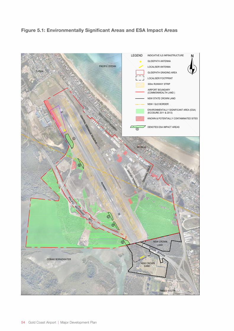
54 Gold Coast Airport | Major Development Plan
Figure 5.1: Environmentally Significant Areas and ESA Impact Areas
LEGEND
A
B
C
D
A
INDICATIVE ILS INFRASTRUCTURE
GLIDEPATH ANTENNA
LOCALISER ANTENNA
GLIDEPATH GRADING AREA
LOCALISER FOOTPRINT
300m RUNWAY STRIP
AIRPORT BOUNDARY(COMMONWEALTH LAND )
NSW STATE CROWN LAND
NSW / QLD BORDER
ENVIRONMENTALLY SIGNIFICANT AREA (ESA)(ECOSURE 2011 & 2013)
KNOWN & POTENTIALLY CONTAMINATED SITES
DENOTES ESA IMPACT AREAS
E
PACIFIC OCEAN
TUGUN
BILINGA
TWEED SOUTH
COBAKI BORADWATER
GOLD COAST HIGHWAY
(M1)
RUNWAY
CENTRAL DRAINAGE RESERVE
GC AIRPORT TERMINAL
MOTORWAY
PACIFIC
NSW CROWNLAND
TUGUNBYPASS
TERM
INAL
DRI
VE
32
14
NSW CROWNLAND
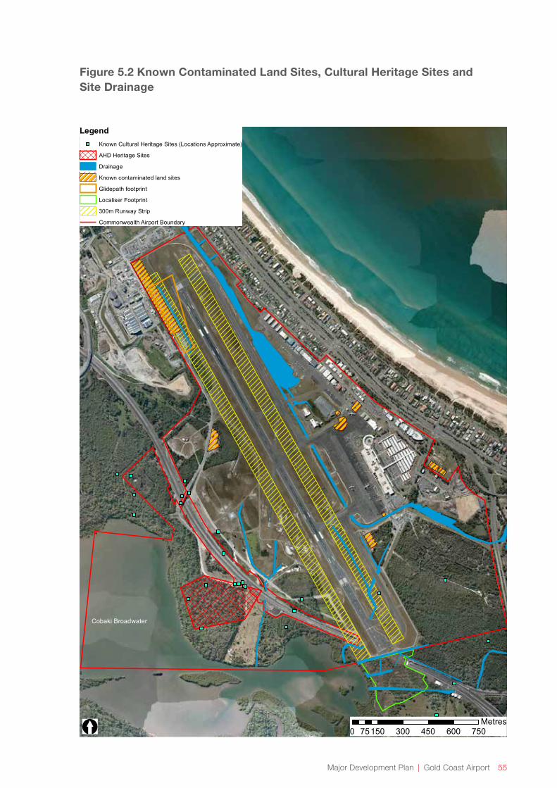
Major Development Plan | Gold Coast Airport 55
Figure 5.2 Known Contaminated Land Sites, Cultural Heritage Sites and Site Drainage
Cobaki Broadwater
[
LegendKnown Cultural Heritage Sites (Locations Approximate)
AHD Heritage Sites
Drainage
Known contaminated land sites
Glidepath footprint
Localiser Footprint
300m Runway Strip
Commonwealth Airport Boundary
0 150 300 450 600 75075Metres

56 Gold Coast Airport | Major Development Plan
5.4 Surface and Groundwater
5.4.1 Baseline Conditions
Glidepath Footprint and 300 metre Runway Strip
There are two significant surface water bodies on the airport land, namely the Cobaki Broadwater and the drainage reserve (Figure 5.2). The Cobaki Broadwater is located along the western boundary of the Cobaki Environmental Precinct. Commonwealth airport land west of the runway discharges to the Cobaki Broadwater. The majority of stormwater runoff from the eastern side of the main runway discharges into the drainage reserve.
The drainage reserve within Gold Coast Airport commences at Betty Diamond Park to the north and leaves the airport at the southeast discharging to Kirra Beach via the Gold Coast City Council drainage network. It has been substantially modified through historic land use activities and is piped or channelised along most of its length. The drain receives stormwater from an urban catchment of approximately 3.7 square kilometres and is tidal towards the southern end of the airport (GCAPL 2011).
A water quality monitoring program is in place at Gold Coast Airport to identify impacts specifically from airport activities by assessing water quality both entering and leaving Gold Coast Airport. Surface water quality is monitored at sites within the drainage reserve, drainage channels leading to the Cobaki Broadwater and the Cobaki Broadwater itself. Water quality monitoring shows that while water within the drainage system upstream of airport activities often shows signs of low-level hydrocarbon, heavy metal and other forms of contamination, monitoring of the airport section indicates a general reduction in these contaminants as they pass through the airport’s drainage system.
Several drainage lines have been constructed within the airport and surrounds including the glidepath footprint and 300 metre runway strip.
Beneath the airport, shallow alluvial sands and gravel deposits form a shallow, unconfined aquifer. The sands are saturated from approximately 0.5 - 0.6 metres below the ground level. Groundwater flows into the Cobaki Broadwater, the drainage reserve, other drainage channels, and low lying areas across the airport.
Localiser Footprint
The two main drainage lines in the localiser footprint are man-made, predominantly tidal and associated with the Cobaki Broadwater (Figure 5.2). There is also a drain immediately south of the runway which runs along the boundary of the airport and north of the localiser footprint area. Overland flow from the bushland areas to the east of the Tugun Bypass also drain into the area.
Flood modelling has been completed for the localiser footprint area. The drainage and earthworks design will be further developed to consider flood modelling results.
Surface water monitoring undertaken in the localiser footprint (Precise Environmental 2014b) identified that the physico-chemical water quality in the drains was typical of that expected of low-lying coastal wetlands and in general was consistent with water quality indicators. Whilst nutrient levels exceeded the water quality objectives this is expected of drainage from wetland areas after rainfall events.
Groundwater monitoring in the localiser footprint identified that the groundwater table is generally shallow in the area and tends to rise after significant rainfall. Dissolved metal concentrations in groundwater were generally compliant with water quality objectives (ANZECC/ARMCANZ 2000, marine aquatic ecosystem trigger values for slightly to moderately disturbed ecosystems), except for iron which was elevated, as is typical of environments where acid sulfate soils are present.
5.4.2 Assessment of Impacts
Glidepath Footprint and 300 metre Runway Strip
The existing open drainage line in the glidepath footprint will be relocated to provide the required level area for the glidepath facility. Erosion and sediment control measures will be implemented during the works and the impact to surface and groundwater is expected to be negligible. The change to surface water flows will be localised and is not expected to result in changes to vegetation at the glidepath footprint or surrounds, which is currently a grassed area. Due to the distance of the glidepath footprint from the Cobaki Broadwater (greater than 500 metres) there is not expected to be any impact to habitats or water quality in the Cobaki Broadwater.
Other than the drainage line relocation within the glidepath footprint, drainage lines within the 300 metre runway strip will not be impacted by the works.

Major Development Plan | Gold Coast Airport 57
Localiser Footprint
The open earth tidal drains traversing the ground pad at the localiser footprint will be diverted around the pad to maintain drainage patterns at the site. Impacts to surface water flows from the new drains at the site would be localised and temporary (during the construction of the new drains) and would be unlikely to affect surface flows on Commonwealth airport land to the north of the localiser footprint. Impacts to water quality during construction are expected to be localised and temporary and will be managed through the implementation of an Erosion and Sediment Control Plan and Acid Sulfate Soils Management Plan during construction.
Following construction, impacts to water quality in the localiser footprint area and surrounds (including the airport drain to the north of the localiser footprint) may occur due to the replacement of vegetation with grass. It has been identified that cutting of grass on the airport as part of normal airport operations, contributes organic phosphorous, ammonia and nitrogen to local waterways via decomposition and the transport of organic material. In addition grass cutting contribute to persistently low dissolved oxygen concentrations in waterways at the airport. This is again due to the transport of organic matter. It is possible that cutting of grass in the localiser footprint could result in similar impacts.
Vegetation influences flows of surface water and the infiltration of water through soils, therefore vegetation clearing at the site may have a minor effect to surface water flows and infiltration at the localiser footprint. However as only a small portion of the footprint will be hardstand and the majority will be grassed, the impact to surface flows and infiltration will be reduced and is not expected to have impacts on airport land to the north. Acid sulfate soils testing undertaken at the localiser footprint and surrounds has identified that the small rate of consolidation associated with the bulk fill is unlikely to have any significant impact on the local water table or normal interactions between acid sulfate soils, groundwater and the adjacent surface waters of the Cobaki Broadwater. It is also unlikely that vegetation clearing in the localiser footprint will significantly affect groundwater (including groundwater flows on airport land to the north) due to the area and type of vegetation being cleared, and the direct tidal influence of the Cobaki Broadwater on the groundwater in the area. Construction of the earth pad may result in short-term, localised impacts to groundwater levels.
The perimeter road around the localiser footprint has the potential to act as a barrier to tidal flows into the area, however cross drainage culverts will be incorporated under the access road to enable continued tidal exchange in the western portion of the localiser footprint.
Management for impacts to surface and groundwater would include investigating the need for water quality improvement devices, implementation of an Erosion and Sediment Control Plan during construction, and stabilisation of the realigned drainage channels as soon as possible after construction. Further management measures will be investigated and mitigated through design, monitoring and adaptive management. Flood modelling for works associated with the localiser footprint has been completed. The modelling results will be used in the detailed design of drainage and earthworks to minimise any impacts.
Preliminary investigations have indicated the project will result in a negligible to minor impact on surface and groundwater in the localiser footprint.
58 Gold Coast Airport | Major Development Plan
5.5 Habitat Values and Wildlife Corridors
5.5.1 Baseline Conditions
Glidepath Footprint
The glidepath footprint doesn’t contain any identified ESAs nor does it contain significant environmental values.
300 metre Runway Strip
Figure 5.1 shows the ESA Impact Areas within the 300 metre runway strip.
The 300 metre runway strip is within the runway precinct and this land is managed primarily for the purpose of aircraft landing, take off and taxing operations etc. The area is largely mown grassland; however it overlays small patches of heath, sedgeland and saltmarsh. It is also subject to GCAPL’s Bird and Wildlife Hazard Management Plan. This means that fauna in this area posing a risk to operations would be subject to active management to deter their presence. Although the plan limits the occurrence of some species, heath, sedgeland and saltmarsh vegetation in the 300 metre runway strip does attract and provide habitat for some fauna not posing a risk to operations.
The most northern ESA within the 300 metre runway strip, ESA Impact Area A, includes an area which is mapped as Least Concern Regional Ecosystem (RE, vegetation communities mapped in Queensland) with a 60/40 percent mix of 12.2.12 and 12.2.9 respectively (i.e. 12.2.12 is closed heath on seasonally waterlogged sand plains, whilst 12.2.9 is Wallum Banksia (Banksia aemula) woodland on dunes and sand plains, usually on deeply leached soils).
ESA Impact Areas B to D are at the fringes of larger areas of vegetation. The areas are predominantly heathland, with a small area of sedgeland in ESA Impact Area B. The south-eastern side of the 300 metre runway strip also contains strips of sedgeland associated with drainage lines. Despite ESA mapping undertaken previously indicating it has low environmental value, later surveys have detected Wallum Froglet in this sedgeland area providing evidence that it does contain some environmental value.
ESA Impact Area E is an area of saltmarsh adjacent to the airside road. This area is mapped as a SEPP 14 wetland. ESA Impact Area E is likely to provide habitat for aquatic fauna when it is inundated during higher tides. To the south of, and partially within ESA Impact Area E, is a mangrove-lined drain which drains to the Cobaki Broadwater. Similar to the areas of saltmarsh habitat in the localiser footprint, saltmarsh and mangroves within and adjacent to ESA Impact Area E are likely to provide high tide roost habitat for shorebirds that utilise feeding areas in the Cobaki Broadwater.
Localiser Footprint
The localiser footprint has been investigated as part of previous ecological assessments undertaken for the Tugun Bypass and a number of subsequent investigations including a site survey for the ILS project which included vegetation mapping verification, refer Figure 5.3. There are 16 different vegetation communities mapped, which can be summarised as follows:
→ Bare Twig-rush (Baumea juncea) and Common Reed (Phragmites australis) sedgeland / rushland;
→ Swamp She-oak (Casuarina glauca) low open forest, with various ground covers, such as Setaria (Setaria sphacelata),
→ Swamp She-oak and Broad-leaved Paperbark (Melaleuca quinquenervia) open forest;
→ Exotic grassland;
→ Mangrove forest to open woodland;
→ Salt Couch (Sporobolus virginicus) (salt marsh);
→ Prickly Couch (Zoysia macrantha) grassland (salt marsh).
There is evidence that the vegetation communities in the localiser footprint have changed in recent years. During the Tugun Bypass flora and fauna surveys, some of the land in the middle of the localiser footprint was considered to be Swamp Oak Woodland; however the ecological community appears to have since changed to a more brackish environment, as evidenced by the now widespread existence of saltmarsh as well as areas dominated by a ground layer of species such as Bare Twig-rush, Common Reed and Mangrove Fern (Acrostichum speciosum). Such a change is reasonable to expect due to the potential alterations in drainage that may have resulted from construction of the Tugun Bypass, with some influence also from natural change. In regards to the latter, the area has undergone a significant change in the last 40 years. The localiser footprint was originally cleared for agriculture, and the current vegetation communities (including fringing mangroves) appear to have since grown, refer Figure 5.4.
Major Development Plan | Gold Coast Airport 59
Vegetation communities in the localiser footprint have also been identified as Endangered Ecological Communities (EECs) under the TSC Act. These are mapped in Figure 5.5 and include:
→ Coastal Saltmarsh in the New South Wales North Coast, Sydney Basin and south east corner bioregions;
→ Swamp Oak Floodplain Forest of the New South Wales north coast, Sydney basin and south east corner bioregions;
→ Swamp Sclerophyll Forest on coastal floodplains of the New South Wales north coast, Sydney basin and south east corner bioregions;
→ Subtropical Coastal Floodplain Forest of the New South Wales north coast bioregion.
The Coastal Saltmarsh EEC under the TSC Act corresponds to the Subtropical and Temperate Coastal Saltmarsh Ecological Community (STCSEC), which is considered a Vulnerable Threatened Ecological Community (TEC) under the EPBC Act.
The Conservation Advice for the STCSEC provides a synopsis of studies that have estimated the original and current extent of the community, as follows:
“There is scattered information about the extent and decline of the Coastal Saltmarsh in NSW. Keith (2004) estimated that the current area of Coastal Saltmarsh covered an area of 7000 to 12 000 ha and that about 30 to 70% had been cleared since European settlement. West et al. (1985, in OEH 2011a) estimated the extent of Coastal Saltmarsh in NSW to be approximately 5700 ha while Creese et al. (2009) estimated the extent as 7259 ha. More recently, Daly (2013) summarised information about the extent of saltmarshes across all natural resource management regions and estuaries within NSW. Refer Table 5.2. (This indicated the ecological community covered an area of 7240 ha – i.e. it fell towards the lower end of Keith’s (2004) range. Although Daly (2013) provided no overall estimate of loss across NSW, he did notethatspecificestuariesshowedlossesofsaltmarshranging from 12 to 97 percent. In some cases there were apparent increases in saltmarsh extent but it was unclear whether this was due to actual expansion of the ecological community or improved mapping techniques. Tozer et al. (2010) determined the current extent of estuarine saltmarshes on the south coast of NSW (from Sydney to the Victorian border) to be about 2167 ha and estimated that this represented <50 percent of the original extent.” (TSSC 2013, pp. 56-57)
Table 5.2: Estimate of current extent (hectares) for the subtropical and temperate coastal saltmarsh ecological community in NSW (from TSSC 2013)
Region Daly (2013) Tozer (2010)
Northern Rivers (Gold Coast Airport and surrounds is in this region)
2230
Hunter/Central Rivers 3270
Hawkesbury Nepean 290
Sydney Metropolitan 190 2167
Southern Rivers 1260
TOTAL 7240 79571

60 Gold Coast Airport | Major Development Plan
On the basis of the available survey data for New South Wales, the TSSC (2013) estimates that the current extent of the STCSEC ecological community is likely to be about 7000 to 8000 hectares. The TSSC (2013, pp.57) also states that the decline in extent is recognised to be highly variable but is estimated to be between 30 to 70 percent across the state. The Office of Environment and Heritage note that further reduction and fragmentation have occurred since the estimates within West et al. (1985 in OEH 2011a). As per Table 5.2, it is estimated that approximately 2230 hectares occur in Northern Rivers (Daly, 2013, in TSSC 2013).
The current extent of the other three ecological communities across New South Wales (Subtropical Coastal Floodplain Forest; Swamp Oak Floodplain Forest; and Swamp Sclerophyll Forest on Coastal Floodplains) is not fully known, though they are expected to be much less than 30 percent of their original ranges (OEH 2011b, c and d). For example, there were less than 350 hectares of each of these EECs within the Tweed lowlands in 1985 (Pressey & Griffith, 1992, in OEH 2011b, c and d).
The localiser footprint also has an area of SEPP 14 Wetland mapped on the western side, refer Figure 5.5. The areas of coastal saltmarsh and mangroves within the localiser footprint are likely to provide habitat for aquatic fauna when inundated during higher tides, and also provide high tide roost habitat for shorebirds that utilise feeding areas in the Cobaki Broadwater. However as described in Section 5.6, Swamp Oak, mangrove and sedge have encroached into the salt marsh resulting in a deterioration of shorebird habitat quality (Australian Wetlands 2010) for roosting and foraging, and declines in the number of birds using the site.
Fisheries Resources
The mangroves that line the Cobaki Broadwater are important habitats that form nursery areas for estuarine species and thereby contribute to the fisheries values of the Broadwater. Saltmarsh areas can also form habitat and shelter for fish during higher tides and are a source of nutrients to estuaries. The strip of mangroves along the Cobaki foreshore, west of the localiser footprint will remain which will assist in minimising the impacts to the fish habitat values of this area of the Cobaki Broadwater. The retention of saltmarsh to the west of the localiser earth pad and the design of the perimeter road for continued tidal inundation and connectivity will further minimise the impact to fish habitat values in the localiser footprint and allow for continued nutrient exchange with the Cobaki Broadwater.
Connectivity
Fundamental requirements for terrestrial fauna connectivity (Lindenmayer & Nix, 2002) are largely absent in and around the localiser footprint (i.e. between the Cobaki and habitat east of the localiser footprint). The current barriers to terrestrial wildlife movement in and around the localiser footprint include:
→ The narrow pinch-point area of land that exists alongside the Cobaki Broadwater and the Tugun Bypass;
→ The drainage channels and pinch-points associated with narrow drainage crossings;
→ The disturbed habitat and pinch point associated with the Tugun Bypass running east west across the tunnel roof;
→ The airside security fencing.
It is likely that these barriers provide significant hindrance to terrestrial connectivity for most terrestrial fauna between the Cobaki and habitat to the east of the Tugun Bypass. For instance, sedentary forest birds (e.g. Fairy Wrens) are known to have high resistance to mobility across land cover other than forests; though other volant species that inhabit large home ranges and a variety of habitats (e.g. bats, or bird species such as crows, cockatoos and parrots) will not be inhibited by these barriers.
Large mammals (such as koalas and wallabies) and reptiles are also likely to have limited mobility between the habitat east of the Tugun Bypass and the Cobaki due to a combination of the four barriers listed above. The pinch points and tidal drains are also likely to be significant barriers to movement/dispersal for the Common Planigale (Planigale maculata) and other small mammals.

Major Development Plan | Gold Coast Airport 61
5.5.2 Assessment of Impacts
Glidepath Footprint
Negligible impacts to habitat values and wildlife corridors are anticipated in the glidepath footprint.
300 metre Runway Strip
There are five ESA Impact Areas (A to E) within the 300 metre runway strip that will be affected by the project.
Due to the extent of vegetation in ESA Impact Area A that will exceed CASA height requirements, it is not feasible to maintain vegetation in this area. As such, ESA Impact Area A will be cleared entirely. ESA Impact Area A also includes the area of vegetation immediately to the west of the flyover area. Clearing of ESA Impact Area A will result in the loss of approximately 1.3 hectares of remnant habitat (melaleuca forest with a coastal heathland understorey and RE 12.2.12/12.2.9). This has been assessed as a minor adverse impact given the regional representation of this vegetation community.
There will be cumulative impacts to ESAs at the airport (including flora and fauna species and habitats) due to planned ESA clearing for terminal and apron expansion depicted in the Master Plan, to be undertaken as a separate project. That project has been determined by DoE to be a ‘controlled action’ under the EPBC Act and is subject to detailed environmental assessment to determine the appropriate mitigation and offsets. When the two projects are considered together, approximately 22% of total ESAs (terrestrial and aquatic) at the airport are to be cleared, of which the clearing for the ILS Project is a very small component (less than 1%).
As there are only scattered trees/plants that currently exceed height requirements in ESA Impact Areas B to D of the 300 metre runway strip, it is feasible to undertake trimming and selective plant removal (rather than clearing). This will be done as a mitigation measure to reduce the project’s impact on Wallum Sedge Frog and Wallum Froglet, as the sedge and heath layer can be maintained. In this case, plants exceeding the flyover plane will be trimmed, or removed if the height renders the plant unviable (e.g. for large trees or shrubs).
For ESA Impact Areas B to D, trimming and selected plant removal will occur within the south western part of the flyover area to reduce the project’s impact on Wallum Sedge Frog and Wallum Froglet. Plants exceeding the required height will be trimmed, or removed if the height renders the plant unviable (e.g. for large trees or shrubs).
ESA Impact Area E is an area of low growing saltmarsh with a mangrove lined drain to the south. Some scattered trees and mangroves may require trimming or removal in the future if they exceed CASA height requirements.
Trimming and selective plant removal in ESA Impact Areas B to E will result in a negligible impact to habitat values, as the heath, sedge and saltmarsh values can largely be maintained or improved through vegetation management. These areas will therefore be retained as ESAs.
Localiser footprint
Clearing
The localiser footprint is to be cleared and maintained in a cleared state through ongoing vegetation management. The assessment below considers full site clearing to conservatively assess the impacts, however where possible, existing ground cover and low growing saltmarsh vegetation west of the localiser earth pad will be retained.
The localiser footprint is approximately 7.7 hectares in area, of which approximately 0.5 hectares was previously cleared as part of the Tugun Bypass Tunnel and now contains some regrowth and planted vegetation (i.e. above the tunnel on Lot 112 DP 1202048). Therefore the remaining area to be cleared is approximately 7.2 hectares, of which approximately 6.5 hectares is mapped as EEC, refer Figure 5.5.
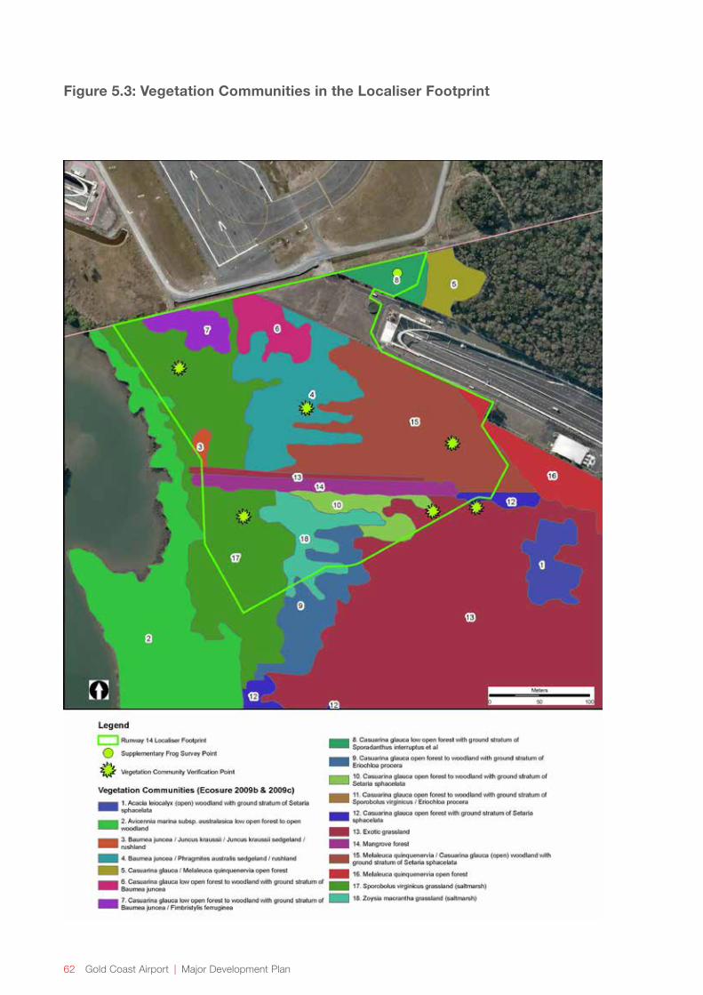
62 Gold Coast Airport | Major Development Plan
Figure 5.3: Vegetation Communities in the Localiser Footprint

Major Development Plan | Gold Coast Airport 63
Figure 5.4: Historical (1975) Aerial Image of Localiser Footprint (black and white) with Current Aerial Image (colour)
LEGEND
COMMONWEALTH AIRPORT BOUNDARY
RUNWAY 14 LOCALISER FOOTPRINT
LOCALISER FOOTPRINT
TWEED SOUTH
COBAKI BORADWATER
RUNWAY
TUGUNBYPASS
32

64 Gold Coast Airport | Major Development Plan
Figure 5.5: Wetlands and Endangered Ecological Communities in the Localiser Footprint
Major Development Plan | Gold Coast Airport 65
The vegetation to be cleared consists of:
→ 0.7 hectares of non-EEC vegetation;
→ Four EECs in the area:
» 3.5 hectares of Coastal Saltmarsh (which is both a NSW EEC and listed as a vulnerable TEC under the EPBC Act
» 0.05 hectares of Subtropical Coastal Floodplain Forest;
» 1.2 hectares of Swamp Oak Floodplain Forest;
» 1.8 hectares of Swamp Sclerophyll Forest on Coastal Floodplains.
Of this 3.1 hectares is also mapped as SEPP14 wetland in the area, whilst 4.7 hectares of vegetation meets the definition of SEPP14.
As the current extent of these EECs across the whole of New South Wales is not known (OEH 2011a, b, c and d), the impact of the project within a state wide context cannot be determined with accuracy. However, the clearing of EECs is considered a key threatening process under the NSW Emvironmental Planning and Assessment Act 1979.
On a Commonwealth level, pursuant to Section 18A(4)(b) of the EPBC Act, it is not an offence to have a significant impact on a Vulnerable TEC such as the Subtropical and Temperate Coastal Saltmarsh TEC in the localiser footprint. This is also outlined in the Department of Environment’s Significant Impact Guidelines (2013, pp. 8), which states:
“…listed ecological communities in the vulnerable category of ecological communities listed under the EPBC Act,arenotmattersofnationalenvironmentalsignificancefor the purposes of Part 3 of the EPBC Act (requirements for environmental approvals).”
Despite the EPBC Act listed TEC not being considered a matter of National Environmental Significance for the purposes of Part 3 of the EPBC Act, the TEC does form part of the ‘environment’ as defined under the EPBC Act. Thus, as the clearing in the localiser footprint will be undertaken by a Commonwealth Agency (Airservices Australia) and the SignificantImpactGuidelines1.2apply, the impact to the EPBC Act listed TEC has been considered in this assessment.
The SignificanceImpactGuidelines1.2 provides some guidance on where impacts to ‘plants’ may be considered significant. The guidelines state that a significant impact is likely to occur if medium or large scale vegetation clearance is proposed. Clearance of the 7.7 hectares of vegetation in the localiser footprint as well as vegetation management activities is considered to be small scale vegetation clearance, which according to the guideline, would not be considered a significant impact. Furthermore, the cleared area represents a very small percentage of its current extent in the region, which is estimated at 2230 hectares. Previous land uses have affected the vegetation communities in the localiser footprint and vegetation communities have changed markedly in recent years due to changes in drainage. Weeds are also present in parts of the site.
Future terminal and apron expansion at the airport (a separate project) will also result in clearing of Swamp Sclerophyll Forest EEC, resulting in a cumulative impact of approximately 18ha, of which the ILS clearing is a very small component. The terminal and apron expansion project has been determined by DoE to be a ‘controlled action’ under the EPBC Act, and is currently subject to detailed environmental assessment and identification of appropriate mitigation measures and offsets for residual impacts to significant flora, fauna and ecological communities.
Shorebird Roost Habitat
The area of coastal saltmarsh that is being impacted in the localiser footprint represents a loss of roosting and foraging habitat for shorebirds, particularly for migratory and marine bird species listed under the EPBC Act that inhabit the Cobaki Broadwater and more widely, the Tweed River Estuary.
The Department of Environment’s Significant Impact Guidelines 1.1 (2013, pp. 12) state that:
“Anactionislikelytohaveasignificantimpactonamigratory species if there is a real chance or possibility that it will substantially modify, destroy or isolate an area of important habitat for a migratory species.”

66 Gold Coast Airport | Major Development Plan
Significant Impact Guidelines 1.1 (2013, pp. 12) state an area of ‘important habitat’ for a migratory species is:
a. “habitat utilised by a migratory species occasionally or periodically within a region that supports an ecologicallysignificantproportionofthepopulationof the species; and/or
b. habitat that is of critical importance to the species at particular life-cycle stages; and/or
c. habitat utilised by a migratory species which is at the limit of the species range; and/or
d. habitat within an area where the species is declining.”
In addition to this, the Significant Impact Guidelines for 36 Migratory shorebird species (DEWHA 2009) identifies an area as being important habitat if:
1. The site is identified as internationally significant; or
2. The site supports:
a. at least 0.1 percent of the flyway population of a single species;
b. at least 2,000 migratory shorebirds; or
c. at least 15 shorebird species.
For Latham’s Snipe (Gallinago hardwickii), habitat is considered ‘important habitat’ when it has been identified as internationally important for the species, or the site supports at least 18 individuals of the species, and the site has naturally occurring open freshwater wetland with vegetation cover nearby (DEWHA 2009).
Further to this, internationally important shorebird sites within the East-Australasian Flyway include those that support 20,000 or more shorebirds or 1 percent of the Flyway population of a migratory shorebird species or subspecies (Environment Australia 2002), as per the Ramsar Convention.
The localiser footprint is part of the Tweed River Estuary. Watkins (1993) originally classified the Tweed River Estuary as being nationally important for Whimbrel (Numenius phaeopus); however Australian Wetlands (2010), Bamford et al. (2008) and Rohweder have noted that the Tweed River Estuary is no longer considered important (nationally or internationally) for any species of migratory shorebird.
Australian Wetlands (2010) state that the Tweed River Estuary is likely to be in the top 10 most important sites (ranked about 8) for New South Wales but is less important in an Australian context (Australian Wetlands 2010, pp. 70). Australian Wetlands (2010) predicts the population of shorebirds to be well below 1,000; though the Tweed River estuary supports around 22 migratory species.
Thus, the Tweed River Estuary would be considered important national habitat, using the definition used by the Department of Environment (DEWHA 2009).
Where feasible, low-growing saltmarsh species will be retained west of the earth pad within the localiser footprint.
As the action will not;
1. Substantially modify migratory bird habitat available in the Cobaki Broadwater and wider Tweed River Estuary (as per Significant Impact Guideline 1.1); or
2. Result in the loss of important habitat that causes a significant reduction in the capacity of the habitat to support migratory shorebirds (as per the Significant Impact Guidelines for 36 Migratory shorebird species);
It has been assessed that the clearing of roost habitat is unlikely to result in a significant impact as defined under the EPBC Act.
During construction, impacts to fish habitat values may arise from erosion and sedimentation or disturbance of acid sulfate soils which could result in reduced water quality in the Cobaki Broadwater if not managed adequately. Minimising the disturbance footprint through the retention of saltmarsh to the west of the localiser earth pad will significantly reduce this impact, in addition to the implementation of erosion and sediment controls and acid sulfate soil management during construction which are described in Section 5.10. Despite these measures there is likely to be a localised and temporary increase in turbidity adjacent to the localiser footprint during construction. Water quality monitoring will be conducted before, during and after construction so that the effectiveness of erosion and sediment controls can be assessed and improved if necessary.
Following construction, the site will be stabilised, tidal inundation will continue across the western portion of the site, and the realigned drainage channels will continue to drain to the Cobaki Broadwater. Therefore the impact to fisheries resources during operation would be low adverse, arising from the loss of some saltmarsh habitat.
Connectivity and Edge Effects
Currently, several significant barriers to connectivity exist between the Cobaki Broadwater and habitat on the eastern side of the Tugun Bypass, however there is a narrow corridor above the Tugun Bypass tunnel. Due to the proposed perimeter fencing and clearing, this narrow corridor (which connects habitat either side of the Tugun Bypass) will be severed.

Major Development Plan | Gold Coast Airport 67
Installation of the ILS will also result in the existing narrow Cobaki Broadwater foreshore west of the runway being extended south and further narrowed. This would be expected to reduce connectivity for terrestrial species, however some connectivity will be maintained along the banks of the Cobaki Broadwater for fauna that inhabit mangrove forest (e.g. Mangrove Honeyeater (Lichenostomus fasciogularis) or Collared Kingfisher (Todiramphus chloris).
The alignment of the road and fence in the northwest corner of the localiser footprint area has been planned to minimise the extent to which the corridor along the Cobaki foreshore is impacted.
Impacts to connectivity in the localiser footprint would also potentially affect connectivity further north on Commonwealth airport land.
Given the poor current condition of connectivity in the area and the current significant barrier effects between the Cobaki and areas east of the localiser footprint, construction of the ILS is not expected to result in significant impact to current levels of connectivity.
Works in the localiser footprint may also create minor edge effects for the mangrove and salt marsh community along the banks of the Cobaki Broadwater. Edge effects may include minor weed colonisation and greater wind exposure (potentially leading to increased evapotranspiration or direct damage).
AssessmentofSignificance
It has been assessed that the installation of ILS infrastructure in the localiser footprint will result in a minor to moderate adverse impact to habitat values and wildlife corridors, primarily due to the impact of habitat clearance.
5.6 Significant Flora and Fauna
5.6.1 Baseline Conditions
The term ‘significant species’ includes migratory and marine species listed under the EPBC Act as well as threatened species. It also includes species that may be considered of special significance (e.g. due to limited distribution) though are not protected under State or Commonwealth legislation. The term ‘threatened species’ includes:
→ Species listed under the EPBC Act as threatened;
→ Species listed as Extinct, Endangered, Vulnerable or Near Threatened under the NC Act; and/or
→ Species listed as Critically Endangered, Endangered or Vulnerable under the TSC Act.
Several studies over the last 10 years have assessed the presence of threatened species across the ILS study areas, and the presence of habitat for significant species was one of the considerations in the identification of ESAs. Due to the degree of environmental change that has happened across some of the study areas over time, the age of the studies and these changes have been taken into account within this assessment for the MDP.
Data was sourced from the existing reports (including assessments undertaken during the identification of ESAs at the airport), EPBC Protected Matters Search Tool (PMST), the Queensland Department of Environment and Heritage Protection’s Wildlife Online Search Tool and the Atlas of New South Wales Wildlife.
The Atlas of New South Wales Wildlife included 2268 records from 670 species, with 217 of these being significant species (within the default 10 square kilometre search area). The EPBC PMST identified 41 listed threatened species and 42 migratory species which may occur in the search area, or whose habitat may occur in the search area. The Queensland Wildlife Online Search results show that four significant species have been observed within the search area.
No significant fauna or flora species were identified in the study area during the site surveys that was undertaken for this assessment. However, previous studies have identified threatened species within the area, and these are further discussed in the sections below.

68 Gold Coast Airport | Major Development Plan
Glidepath Footprint
Land within the glidepath footprint is mown grassland or hardstand managed as part of the runway precinct. This provides clear zones for safe aircraft landing, take off and taxiing. A grassed, open drainage line is present in the glidepath footprint. This area is not considered to provide suitable habitat for threatened aquatic or terrestrial flora or fauna species.
300 metre Runway Strip
Fauna
The 300 metre runway strip is within the current airfield and this land is managed primarily for the purpose of aircraft landing, take off and taxiing operations etc. It is also subject to GCAPL’s Bird and Wildlife Hazard Management Plan. This means that fauna in this area would be subject to active management (directly removing or reducing the numbers of birds and other fauna where they pose a risk to aircraft operations).
There are ESAs within the 300 metre runway strip that provide habitat for Wallum Froglet and Wallum Sedge Frog. Monitoring undertaken as part of GCAPL’s Significant Terrestrial Fauna Monitoring Program has identified Wallum Froglet and Wallum Sedge Frog as occurring in all of these areas in recent years. Refer Section 5.6.2 for habitat assessment for Wallum Sedge Frog.
The species likelihood assessment (Appendix A) also shows that a number of fauna species are known to occur, or could possibly occur in the 300 metre runway strip. These include:
→ Two amphibian species, with one (Wallum Sedge Frog)listed under the EPBC Act and TSC Act, and the other (Wallum Froglet) listed under the TSC Act and NC Act;
→ 22 bird species, with:
» 12 listed under the EPBC Act as migratory or marine;
» One listed as vulnerable under the EPBC Act (Red Goshawk (Erythrotriorchis radiatus));
» 10 listed under the TSC Act;
» Two listed under the NC Act.
→ 10 mammal species, with:
» One (Grey-headed Flying Fox (Pteropus poliocephalus)) listed under the EPBC Act as vulnerable;
» All ten listed under the TSC Act. Nine of these are bat species, with the Common Planigale being the only other mammal. It is worth noting that there are only small patches of suitable habitat for the Grey-headed Flying Fox.
The presence of habitat for legislatively significant species was a factor considered in the identification of ESAs at the airport.
Flora
Table 5.3 identifies the significant flora species that may occur in the 300 metre runway strip. This is summarised from the Species Likelihood of Occurrence Assessment in Appendix A.

Major Development Plan | Gold Coast Airport 69
Table 5.3: Significant flora species that may occur within the 300 metre Runway Strip
Species Status Distribution Likelihood of occurrence in the 300 metre runway strip
Christmas Bells Blandfordia grandiflora
Endangered under the Queensland NC Act
North from the Hawkesbury River area and inland to Glen Innes district.
Known. This species is found in the 300 metre runway strip, though the known population will not be impacted by the project as it will be below vegetation trimming requirements.
Dark Greenhood Pterostylis nigricans
Vulnerable under the NSW TSC Act
The Dark Greenhood occurs in north-east New South Wales north from Evans Head, and in Queensland.
Possible. Marginally suitable habitat exists in the 300 metre runway strip.
Fringed Baeckea diosmifolia
N/A This species is generally found along the New South Wales coastline otherwise (Wilson 1997).
Possible. This species is not listed as threatened on a Commonwealth or state level, though the only known location on the Gold Coast is at the Gold Coast Airport. It is not known to be present in ESA Impact Areas A to E.
Lemon-scented grass Elyonurus citreus
Endangered under the New South Wales TSC Act
Lemon-scented Grass occurs north from Grafton in New South Wales. It is only known from localities south of Casino, north-west of Grafton, near Cudgen Lake on the Tweed coast and in Yuraygir National Park. It also occurs in Queensland, Northern Territory, Western Australia and New Guinea.
Possible. Suitable habitat exists in the 300 metre runway strip.
Pink nodding orchid Geodorum densiflorum
Endangered under the New South Wales TSC Act
North from the Macleay River on the north coast of New South Wales.
Possible. Suitable habitat exists.
Spider Orchid Dendrobium melaleucaphilum
Endangered under the New South Wales TSC Act
Occurs in coastal districts and nearby ranges, extending from Queensland to its southern distributional limit in the lower Blue Mountains.
Possible. There is potential due to occurrence of the Prickly Paperbark (Melaleuca stypheliodes) in areas east of the runway.
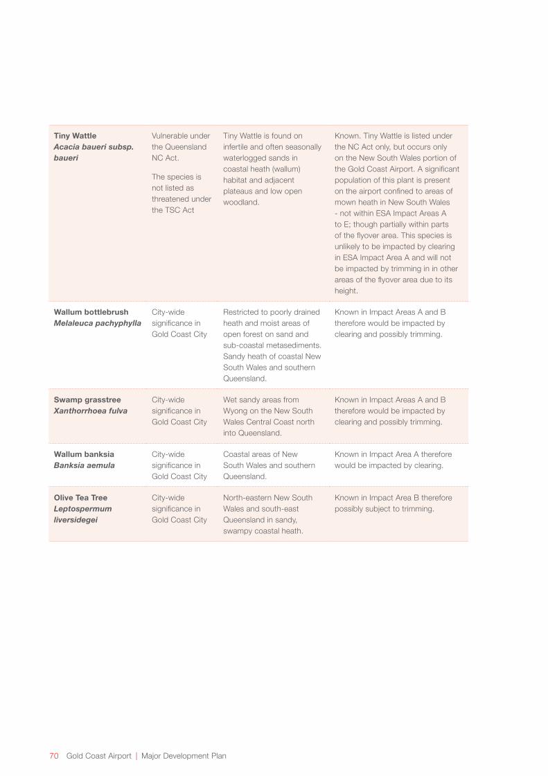
70 Gold Coast Airport | Major Development Plan
Tiny Wattle Acacia baueri subsp. baueri
Vulnerable under the Queensland NC Act.
The species is not listed as threatened under the TSC Act
Tiny Wattle is found on infertile and often seasonally waterlogged sands in coastal heath (wallum) habitat and adjacent plateaus and low open woodland.
Known. Tiny Wattle is listed under the NC Act only, but occurs only on the New South Wales portion of the Gold Coast Airport. A significant population of this plant is present on the airport confined to areas of mown heath in New South Wales - not within ESA Impact Areas A to E; though partially within parts of the flyover area. This species is unlikely to be impacted by clearing in ESA Impact Area A and will not be impacted by trimming in in other areas of the flyover area due to its height.
Wallum bottlebrush Melaleuca pachyphylla
City-wide significance in Gold Coast City
Restricted to poorly drained heath and moist areas of open forest on sand and sub-coastal metasediments. Sandy heath of coastal New South Wales and southern Queensland.
Known in Impact Areas A and B therefore would be impacted by clearing and possibly trimming.
Swamp grasstree Xanthorrhoea fulva
City-wide significance in Gold Coast City
Wet sandy areas from Wyong on the New South Wales Central Coast north into Queensland.
Known in Impact Areas A and B therefore would be impacted by clearing and possibly trimming.
Wallum banksia Banksia aemula
City-wide significance in Gold Coast City
Coastal areas of New South Wales and southern Queensland.
Known in Impact Area A therefore would be impacted by clearing.
Olive Tea Tree Leptospermum liversidegei
City-wide significance in Gold Coast City
North-eastern New South Wales and south-east Queensland in sandy, swampy coastal heath.
Known in Impact Area B therefore possibly subject to trimming.

Major Development Plan | Gold Coast Airport 71
5.6.2 Results of the Habitat Assessment for Wallum Sedge Frog in ESA Impact Area A
ESA Impact Area A , refer Figure 5.1, has been identified as having suitable vegetation for Wallum Sedge Frog as the species is known to have strong affiliations with cylindrical, erect sedges such as sedges (Baumea sp.) and Grey Sedge (Lepironia articulata). A targeted habitat assessment and survey of Area A was undertaken for the project, to determine its suitability for the Wallum Sedge Frog. Area A was largely found to be unsuitable habitat for the Wallum Sedge Frog as outlined below.
No frog species were heard calling during the survey and only one species was visually observed during the survey. This was Striped Rocket Frog (Litoria nasuta ), which was visually observed in the mown sedge area that borders ESA Impact Area A. Striped Rocket Frog is not listed as a threatened species under state or Commonwealth legislation.
Based on quarterly frog surveys undertaken as part of the Significant Fauna Monitoring Program since 2006 and other historical data, there are previous records of the species in ESA Impact Area A:
→ One record in the mid-north of ESA Impact Area A recorded in the early 2000’s (actual date is unknown).
→ Two records on the southern tip of ESA Impact Area A. These were recorded on the 10th of October 2011 and the 18th of January 2012. Two Wallum Sedge Frog were heard on each date; however this indicates presence only, not population numbers.
→ Six records in the northern part of ESA Impact Area A in February 2015. These records occurred after the submission of the EPBC referral for the project, however the information was provided to DoE within the referral decision period and prior to the referral determination.
It appears that the 2011/2012 records of Wallum Sedge Frog in ESA Impact Area A came at a time when the population was increasing. Monitoring undertaken from July 2011 to June 2012 as part of the Significant Fauna Monitoring Program recorded a total of 78 Wallum Sedge Frog calls in spring and summer. This total is more than in the previous period (2010 - 11) when only 41 were recorded and the highest number of calls (66 individuals) was heard during January (summer), which had the highest total rainfall of the four months surveyed. This is the highest number of Wallum Sedge Frogs recorded during a single frog survey, with the next highest (38 individuals) recorded in February 2009.
Although the reasons for recording Wallum Sedge Frog in ESA Impact Area A during the 2011/2012 breeding season are not clear, higher frog populations across the airport site were potentially due to higher rainfall (all years since 2008, except 2011, had above average annual rainfall) and active weed management.
Such a conclusion is consistent with the ecology of the Wallum Sedge Frog as (similar to other frog species) the species is known to be in a state of flux, expanding and contracting according to climatic conditions (amongst other factors). Generally speaking, two sequential summers would provide favourable conditions for an expansion of the population; however other factors would also determine population size. It is worth nothing that despite continued higher than average annual rainfall since the recent observations, evidence shows the population has reduced across the airport.
Monitoring undertaken from July 2012 to June 2013 as part of the Significant Fauna Monitoring Program recorded a 46 percent reduction in Wallum Sedge Frog records from the 2011-12 monitoring period (across the whole airport), and that the 2012-13 monitoring period was similar to that of previous years prior to 2011-2012. This may explain why Wallum Sedge Frog was not recorded in ESA Impact Area A during the 2012-2013 monitoring period.
The 2015 records of Wallum Sedge Frog in ESA Impact Area A also occurred after significant rainfall (the airport has received approximately 800mm of rainfall in 2015, which is more than double the average rainfall for the period), therefore is consistent with the above theory that the Wallum Sedge Frog expands into the area after significant rainfall. Habitat observations at the time of the 2015 survey indicate that the area is not likely to be suitable breeding habitat as there is insufficient ponding water.
Other common species less adapted to acidic conditions are also regularly recorded in ESA Impact Area A. This includes Common Sedge Frog (Litoria fallax), Striped Rocket Frog (Litoria nasuta), Tyler’s Tree Frog (Litoria tyleri) and Striped Marsh Frog (Limnodynastes peronii). These frogs are likely to compete for resources and are known to displace Wallum Sedge Frog. In addition, their regular presence indicates the water pH in ESA Impact Area A may be generally too high for Wallum Sedge Frog.

72 Gold Coast Airport | Major Development Plan
ESA Impact Area A may provide low quality suitable habitat for Wallum Sedge Frog; though only during years where the population has increased and the species disperses to less favourable habitat.
The reasons why the area is generally low quality habitat is likely to relate to competition with other frog species, the low frequency of freestanding water and water quality. Further survey of the area (including tadpole surveys) will be conducted prior to works occurring in the area, and if required, an EPBC permit will be obtained for affecting an EPBC-listed threatened species on Commonwealth land.
Localiser Footprint
Fauna
Based on an assessment of species likelihood (see Appendix A), and with reference to the habitats present in the area, a number of significant fauna species are known to occur, or could possibly occur in the localiser footprint. These include:
→ 43 bird species, with 32 of these listed under the EPBC Act (all are migratory or marine) and 18 listed under the TSC Act;
→ Eight mammal species, with none listed under the EPBC Act and all eight listed under the TSC Act. Seven of these are bat species, with the Common Planigale being the only other mammal.
Frogs
Two threatened frog species – the Wallum Sedge Frog and the Wallum Froglet - are known to occur in adjacent areas to the localiser footprint. The Wallum Sedge Frog is listed as vulnerable under the EPBC Act, NC Act and TSC Act, whilst the Wallum Froglet is listed as vulnerable under the NC Act and TSC Act.
The habitat within the localiser footprint is not considered to be suitable for these two species as the Wallum Sedge Frog is generally found in wetlands with emergent reeds, ferns and/or sedges and in undisturbed coastal wallum. The Wallum Froglet is found in similar environments, including Paperbark swamps, sedgeland, and wet or dry heathland and wallum/woodland areas in the sandy coastal lowlands. Both species prefer wetlands characterised by acidic water bodies.
Common Froglet (Crinia signifera), which is not a threatened frog species, was heard during the survey for the ILS project in the small triangle of land to the south east of the localiser footprint. This species prefers less acidic environments and therefore can sometimes indicate that the habitat is unsuitable for the two acid frog species.
SignificantShorebirds
In the localiser footprint, ‘significant shorebirds’ include those listed as migratory, marine or threatened under the EPBC Act, or threatened under the TSC Act.
The mangrove and salt marsh areas in the localiser footprint have previously been referred to as the Pony Club Roost (Australian Wetlands 2010, Parsons Brinckerhoff 2004, Rohweder 2001 & 2007). The Pony Club Roost is one of 11 active migratory bird roosts in the Tweed River Estuary (Australian Wetlands 2010).
In 2001, Rohweder (2001) noted that the Pony Club Roost provided locally important high tide roost habitat for a number of significant shorebird species. However, since 1994, Swamp Oak, mangrove and sedge (Juncus kraussii)has encroached into the salt marsh resulting in a deterioration of habitat quality (Australian Wetlands 2012) for roosting and foraging.
Previous studies on shorebirds in the Cobaki, Rohweder (2001; 2007) and Australian Wetlands (2010) also note that the number of roosting sites used in the Cobaki has reduced due to disturbance and habitat loss.
Significant shorebird species known to use parts of localiser footprint as a high tide roost include:
→ Grey-tailed Tattler (Heteroscelis brevipes);
→ Bar-tailed Godwit (Limosa lapponica)
→ Eastern Curlew (Numenius madagascariensis);
→ Whimbrel (Numenius phaeopus);
→ Pacific Golden Plover (Pluvialis fulva); and
→ Common Greenshank (Tringa nebularis).
All of these species are currently listed as both marine and migratory under the EPBC Act. Other migratory species that utilise the entire Tweed River Estuary may also use the localiser footprint (Wetlands Australia 2012).
Despite the changes to habitat in the localiser footprint and the associated reduction in use by shorebirds, the number of shorebirds using the localiser footprint would also be influenced by population decreases that have occurred in the context of declining migratory bird populations across the Tweed Estuary and Australia more generally (DECCW 2010; Hansen 2011). This is most likely due to habitat destruction within the East-Asian/Australasian Flyway and, more locally in the Tweed River Estuary, foreshore development, increased levels of human recreation, vegetation encroachment, pollution, major projects and dredging (Rohweder 2007).

Major Development Plan | Gold Coast Airport 73
The total population of migratory shorebirds has significantly declined in the Tweed River Estuary (Rohweder 2007, Australian Wetlands 2010) with under half the shorebird numbers observed in 2009, compared to numbers observed between 1987-2002 (Australian Wetlands 2010). The migratory species with substantial population declines in the estuary include Bar-tailed Godwit Curlew Sandpiper (Calidris ferruginea) and Pacific Golden Plover (Australian Wetlands 2010).
Non-Threatened Fauna Species
Non-threatened species are known to exist in the area, including the Swamp Wallaby (Wallabia bicolour) and Common Froglet as well of a range of common bird species.
As part of studies conducted for the Tugun Bypass, there has also been a sighting of a species of Nudibranch (or sea slug) within the mangrove fringed drainage line in the localiser footprint. It is suspected that these are Elysia bangtawaensis (Cobb, 1997), a species that has been recorded in Thailand, India and Australia (Rudman 2007).
Elysia bangtawaensis (or any other Elysia species) is not currently listed as threatened under the TSC Act or EPBC Act. However, Cobb (2007) has suggested the species may have conservation significance because of its highly limited distribution.
Although the recording of the species within the localiser footprint is one of two known locations in Australia, the reason for the small number of known populations of this species may be due to a lack of targeted survey effort (and the difficulty of spotting the species) rather than a limited occurrence of suitable habitats or extant populations. The distribution of the species may also be indicated by the presence of other species of Elysia, which are known to inhabit the region and are common all round Australia except for Tasmania (Burn 1998). This may give further evidence that Elysia bangtawaensis may be present in other areas along the Queensland and New South Wales Coastline. This should be used with caution however, as there is very limited data on the species’ actual distribution.
Flora
Previous surveys of the area and surveys undertaken for this project have not observed significant flora species in the localiser footprint. Pink Nodding Orchid (Geodorum densiflorum) is the only species that has a possibility of occurring in there due to the existence of suitable habitat. There is also a small population of Lesser Swamp Orchid (Phaius australis) (endangered under the EPBC Act and TSC Act) that exists approximately 200m to the east of the localiser footprint, though no suitable habitat exists within the localiser footprint.
Previous and current land uses (agriculture, Tugun Bypass construction, vegetation management on the approach of runway 32 and Pony Club operations) have influenced the types of vegetation in the area. The proximity to other cleared areas has also influenced the current state of the environment. Several declared weeds have been observed in the area, including:
→ Groundsel (Baccharis halimifolia);
→ (Chrysanthemoides monilifera subsp. rotundata);
→ Camphor Laurel (Cinnamomum camphora);
→ Lantana (Lantana camara); and
→ Broad-leaved Pepper Tree (Schinus terebinthifolia).
Weed management to remove widespread occurrence of these and other weeds (e.g. Setaria) is undertaken by GCAPL in and around the localiser footprint which has seen a reduction in the abundance and species of weeds in the localiser footprint.

74 Gold Coast Airport | Major Development Plan
5.6.3 Assessment of Impacts – Significant Flora and Fauna
Glidepath Footprint
No impact is anticipated as no significant flora or fauna have been recorded within, or are likely to inhabit the glidepath footprint.
300 metre Runway Strip
Fauna
Complete removal of ESA Impact Area A (1.3 hectares) will remove this habitat area for Wallum Froglet, though this is expected to provide a minor impact to the species due to the wide occurrence of the species in other areas within the airport boundary, and the extent of known populations along the northern New South Wales and south-east Queensland coastline.
Removal of ESA Impact Area A is likely to result in a minor impact to the other significant species that may inhabit the area. This is because the area is small and fragmented and the habitat type is well represented regionally. In addition, the occurrence of volant species (birds and bats) is reduced due to management activities that discourage their occurrence (i.e. the Airport Bird & Wildlife Hazard Management Plan) and their mobility.
Trimming requirements for the heath and sedgeland within ESA Impact Areas B to D will alter minor portions of heathland/sedgeland habitat on the western side of the runway. The Wallum Froglet and the Wallum Sedge Frog are known to inhabit sedgeland and heathland in these areas.
In ESA Impact Areas B to D, plants that exceed vegetation height requirements will be trimmed or removed if trimming renders the plant unviable. Due to trimming, these areas are likely to become further dominated by sedge and heath species, whilst emergent tree and shrub species will be trimmed or removed.
During trimming and/or selected plant removal, the habitat values will be disturbed; however, management measures can reduce the impact of these works. In the long term, management of vegetation in this area is likely to provide more favourable habitat conditions for species that inhabit heathland and sedgeland as removal of a tall shrub or tree layer frees resources for development of lower heath and sedgeland species.
Hopkins (2003, in Ecosure 2013) examined the temporal and spatial distribution of calling for Wallum Froglet and Wallum Sedge Frog across the airport grounds and found that these species were more likely to occur in ponds with increased ground cover and shrub density. With vegetation management, habitat values will potentially be enhanced for these two wallum frog species.
Trimming is expected to result in a negligible impact to the Common Planigale as this species utilises the ground layer and can persist in environments with varied canopy cover.
Removal of any plants that exceed the height requirements will remove some heath habitat value for birds and bats. However, the impact to these species will be minor because:
→ The occurrence of bird species is reduced due to management activities that discourage their occurrence (i.e. the Airport Bird & Wildlife Hazard Management Plan); and
→ The number of potential habitat trees being impacted will be minimal.
With appropriate management, the habitat values of heathland and sedgeland in ESA Impact Areas B to D will largely remain where trimming and selective plant removal is occurring.
In ESA Impact Area E, there are very few trees that will require trimming or removal as the area is largely low growing saltmarsh with a mangrove-lined drain to the south.
Due to the small scale clearing in ESA Impact Area A and the retention of habitat values in ESA Impact Area B to E, the works in the 300 metre runway strip are not expected to directly impact on listed threatened fauna species and will not substantially reduce or fragment available habitat for native species. The impact of the project to Wallum Sedge Frog and Wallum Froglet that are known to inhabit ESA Impact Areas B to D has been minimised through trimming and selective vegetation removal in preference to clearing.
Major Development Plan | Gold Coast Airport 75
The impacts to fauna in the 300 metre runway strip have been assessed as a minor impact. Further removal of ESAs that contain Wallum Froglet and Wallum Sedge Frog habitat is planned to occur at the airport due to future terminal and apron expansion as depicted in the Master Plan. This would increase the cumulative impact to these species, of which the ILS project is a small component. The terminal and apron expansion has been determined by DoE to be a controlled action under the EPBC Act and is currently subject to detailed environmental assessment and identification of appropriate mitigation measures and offsets for residual impacts to significant flora, fauna and ecological communities.
Flora
Trimming and selective plant removal in ESA Impact Areas B to E will result in a negligible impact to habitat values, as the heath, sedge and saltmarsh values can largely be maintained through vegetation management. Clearing or trimming in the 300 metre runway strip will not impact any known populations of significant flora. If significant flora species are identified during clearing or trimming, the plants will be clearly flagged. Removal or trimming of a plant will not occur until advice is sought on approval requirements and potential ways to minimise the impact (e.g. translocation).
Localiser Footprint
Clearing and construction of access road and fencing within the localiser footprint will remove habitat and reduce habitat connectivity for the significant fauna species identified as occurring or potentially occurring in this area. Most of the species are migratory bird species or bats, though the Common Planigale (vulnerable under the TSC Act) is also identified as potentially occurring in the area. Relocation of the drainage lines in the localiser footprint may also disturb potential habitat for the Nudbranch Elysia bangtawaensis.
Connectivity to and from areas north of the localiser footprint will also be impacted. Where feasible, existing ground cover and low growing vegetation west of the localiser earth pad will be retained to minimise the extent of impact.
The area of coastal saltmarsh that is being impacted represents a loss of roosting habitat for shorebirds, particularly for migratory and marine bird species listed under the EPBC Act that inhabit the Cobaki Broadwater and other areas of the Tweed River Estuary. As the works will not substantially modify migratory bird habitat available in the Cobaki Broadwater and wider Tweed River Estuary, it has been assessed that the clearing of roost habitat is unlikely to result in a significant impact as defined under the EPBC Act, refer Section 5.5.2).
The habitat within the localiser footprint is not considered to be of critical importance for bats as there is limited foraging or roosting habitat for the species. There is also limited suitable habitat available for the Common Planigale and would not support an ecologically significant proportion of their respective populations.
The installation of ILS infrastructure in the localiser footprint is likely to result in a minor adverse impact to fauna due to habitat loss and fragmentation. The impact in the localiser footprint is unlikely to result in a significant impact under the EPBC Act.
Flora
It is unlikely that significant flora species will be directly impacted by the works. Additionally, the current population of the Lesser Swamp Orchid (200 metre to the east of the localiser footprint) will not be impacted by the installation of the ILS.

76 Gold Coast Airport | Major Development Plan
5.7 Cultural Heritage
5.7.1 Baseline Conditions
The ILS project footprint lies within a significant regional cultural landscape known to the Aboriginal people of the Tweed and Gold Coast. A number of cultural heritage sites have been identified in the general locality of the project footprint as identified in Figure 5.2.
During the past fifty years, much of the Gold Coast Airport site has been substantially modified. For most of the site, land reclamation, sand mining and reshaping have been so extensive that physical evidence of Aboriginal occupation is difficult to interpret. However, in relatively undisturbed areas of the airport to the south and west, intact cultural heritage sites have been found. These sites contain large quantities of artefactual material which are an indication of the historic Aboriginal presence in the area.
A due diligence cultural heritage assessment was conducted for the ILS project (Everick Heritage Consultants 2015) and included a desktop study of previous archaeological reports and other literature, field inspections and consultation with Indigenous stakeholders. Searches of Queensland, New South Wales and Commonwealth heritage databases were conducted as part of the study to identify any registered sites within the project footprint and surrounds. Sites identified in these searched are detailed in Figure 5.2.
Subsequent cultural heritage surveys undertaken as part of the Gold Coast Airport Cultural Heritage Management Plan and Project Lift identified a number of new cultural heritage sites within Gold Coast Airport. None of these sites are located within the ILS project footprint with the closest being approximately 75m west of the 300m wide runway strip widening footprint.
One cultural heritage site is located within the 300 metre runway strip. This is an artefact scatter first identified by Hall (1990) on the eastern side of the runway.
No other Indigenous cultural heritage sites or relics were identified in the glidepath footprint, 300 metre runway strip or localiser footprint and no areas were identified that are considered to potentially contain subsurface deposits of significant Aboriginal heritage.
No known Commonwealth Heritage places are located within the project footprint. The cultural heritage assessment conducted for the project did not identify any historic (non-indigenous heritage) within the project footprint.
5.7.2 Assessment of Impacts
Glidepath Footprint and 300 metre Runway Strip
Negligible impact to cultural heritage is anticipated in the glidepath footprint due to no known cultural heritage sites and historical land disturbance.
The known cultural heritage site within the 300 metre runway strip is not expected to be impacted by the works, as no ground disturbance is required in the area which will be maintained in line with the current regime. Negligible impacts to cultural heritage are anticipated in this area.
In discussions during the site walkover with Indigenous stakeholders, potential for further investigation at one location within ESA Impact Area A was raised. Subsequent consultation has determined that an appropriate mitigation strategy would involve a post clearing survey of this area.
The alignment of services within the 300 metre runway strip (power and communication) will be selected to be within soil profiles having evidence of past ground disturbance to minimise the potential impacts to cultural heritage. If installation of services in undisturbed areas is unavoidable, cultural heritage monitoring will be undertaken and a cultural heritage find procedure implemented. The find procedure will be developed as part of the CEMP which is subject to approval by DIRD as part of the building approval process.
The impact to cultural heritage in the 300 metre runway strip is expected to be negligible.
Major Development Plan | Gold Coast Airport 77
Localiser Footprint
No Indigenous cultural heritage sites or relics were identified in the localiser footprint during the due diligence cultural heritage assessment and no areas were identified that are considered to potentially contain subsurface deposits of significant Aboriginal heritage. No historic heritage was identified in the localiser footprint.
A post excavation survey is proposed for the main drainage diversion works in the localiser footprint area. Although potential impacts on physical Aboriginal heritage is extremely low, a cultural heritage find procedure will be included in the CEMP in the event that cultural heritage is encountered during the works.
The impact to cultural heritage in the localiser footprint is expected to be negligible.
5.8 Air Quality, Noise and Light
Movement of machinery and equipment, vegetation clearing and minor earthworks required for the construction of the ILS have the potential to generate noise and air pollutants. The impacts from construction will be short term and localised, and are not expected to impact the nearest sensitive receptors (residential properties) which are located to the east of the airport in Bilinga.
There are not expected to be any significant sources of ground based noise or air emissions arising from operation of the ILS therefore there would be no impact to sensitive receptors adjacent to the airport.
The antennae in the glidepath and localiser footprints will have a red obstacle light, and the buildings in the glidepath and localiser footprints will have a fluorescent light which will only be operational when the building is in use. Due to the distance from sensitive receptors and the low intensity of the lighting, the impact from lighting to sensitive receptors or fauna is expected to be negligible.
Noise associated with the new flights paths associated with the ILS has been assessed in Chapter 6.
5.9 Hazardous Materials
Hazardous materials are substances with the potential to cause harm to persons, property or the environment. During construction and operation of the ILS project, small quantities of hazardous materials such as fuels, paints and solvents and herbicides will likely be present in the project footprint. These materials will be handled and stored in line with relevant standards, therefore there is not expected to be any impact to the environment from hazardous materials.
5.10 Mitigation Measures
Appropriate mitigation measures will be incorporated into the design of the ILS project along with the development of construction and/or operational environmental management plans to mitigate impacts of the development on the environment. The construction and/or operational environmental management plans would include issue-specific plans where relevant, for example:
→ Erosion and Sediment Control Plan;
→ Acid Sulfate Soil Management Plan;
→ Contaminated Land Management Plan;
→ Dewatering Management Plan; and
→ Vegetation Management Plan.
Key mitigation measures for the project that will be incorporated into construction and/or operational plans and adopted in the construction and/or operational phase are detailed below. In addition, the environment strategy for the airport sets out environmental requirements that apply to all activities, and encompasses activities undertaken by airport operators, including GCAPL staff, tenants and contractors. The environment strategy would be applicable to the operation phase of the project.
78 Gold Coast Airport | Major Development Plan
5.10.1 Resource Use
The CEMP will identify opportunities for efficient use of materials and minimisation of waste during construction.
Due to the negligible use of resources during the operation phase, no specific mitigation measures are proposed.
5.10.2 Land
Management of Dust, Erosion and Sedimentation
Construction and maintenance activities will be conducted in a manner that minimises soil erosion and dust generation. An Erosion and Sediment Control Plan will be developed for the construction phase of the project and will consider:
→ Installation of erosion and sediment control measures including sediment fences or sand bags prior to ground disturbance, and measures to remain in place until the site is stabilised following construction;
→ Stabilisation of diverted drainage lines in the localiser footprint and temporary sediment controls such as check dams to be installed until they are stabilised to minimise the risk to water quality in the Cobaki;
→ Mulching, revegetation or other measures applied to cleared areas as soon as possible to stabilise the soil;
→ Dust control will be implemented through watering or other method to reduce dust generation from exposed areas in dry conditions;
→ Any stockpiles will be located within the clearing footprint, away from drainage lines and water bodies, and will be covered or stabilised if remaining for more than one week;
→ Erosion and sediment control measures will be checked regularly during construction and maintained in good working order;
→ The site will be checked daily for signs of erosion and sedimentation and appropriate and reasonable corrective actions taken to rectify any non-conformity: and
→ Tidal inundation of the site
During operation of the ILS, no mitigation measures are expected to be required for dust, erosion and sedimentation.
Management of Acid Sulfate Soils
The acid sulfate soil investigation and management plan prepared for components of the ILS project within the localiser footprint details the appropriate acid sulfate soil
mitigation measures. The Acid Sulfate Soils Management Plan will be implemented during construction, including the following measures:
→ Area of ground disturbance is to be minimised as far as possible;
→ Removal of topsoil and placement of fill to be undertaken in a manner that minimises the duration that sub-soils are exposed;
→ Agricultural lime to be placed over exposed soils following excavation and used to neutralise excavated soils;
→ The treated material may be reused on site where fit for purpose, and if compliant with the relevant pH criteria;
→ Surface water quality monitoring shall be undertaken at the locations and frequencies specified in the acid sulfate soil management plan;
→ The discharge of leachate and/or surface water that has been in contact with acid sulfate soil shall be monitored in accordance with the acid sulfate soil management plan;
→ Containment of untreated acid sulfate soils within bunded areas and treatment of leachate from bunded areas prior to discharge;
→ Regular visual monitoring is to occur at the site to check for signs of acid sulfate soil;
→ If visual and/or water quality monitoring indicates the production and migration of acidic leachate, additional treatment measures will be implemented as necessary; and
→ Excavation will be planned to minimise the extent and duration of dewatering and a site specific Dewatering Management Plan will be prepared for all groundwater extraction that has the potential to expose acid sulfate soil to oxidising conditions.
During operation of the ILS there is not expected to be any impacts to acid sulfate soils so no mitigation measures are required.
Management of Contaminated Land
Further investigation will be conducted prior to construction and, a Contaminated Land Management Plan will be prepared, which will detail the mitigation measures to be implemented during the works, including:

Major Development Plan | Gold Coast Airport 79
→ If excavations occur within areas of contaminated land, measures will be taken to minimise exposure of workers or users of the area through preventing dermal contact and dust through the maintenance of a surface capping layer of 0.5 metres. In the event that the underlying fill is disturbed, procedures will be adopted to minimise the exposure to the subsurface soils during any excavation works and to maintain or reinstate the surface barrier or capping layer once works are completed;
→ Any excess soils or waste generated from excavation works in the identified contaminated area will be assessed and managed appropriately;
→ Any imported soil fill will be verified as free of declared weed species and other contaminants; and
→ In the event that previously unidentified contaminated land or suspected contaminated material is encountered during the works, works will cease in that area and suitably qualified advice sought. If necessary, further testing will be carried out to identify the best management/remediation option to be implemented.
→ The risk of PFC contamination within the project footprint will be assessed as part of the contaminated land management plan. If the risk assessment identifies that there is the potential for PFC contamination, further assessment (including soil and/or water testing) will be conducted and if required appropriate management measures developed in consultation with DIRD prior to construction.
During operation of the ILS there is not expected to be any impacts from contaminated land so no mitigation measures are required.
5.10.3 Surface and Groundwater
Works in the glidepath area and the localiser footprint area have potential to impact upon waterways and drainage during construction.
The following mitigation measures will be incorporated into the construction management plan and implemented during construction to minimise impacts to surface and groundwater in the glidepath footprint:
→ Implementation of an Erosion and Sediment Control Plan as described above;
→ Visual monitoring following completion to check that water quality downstream is not impacted.
During construction at the localiser footprint area, the following mitigation measures for surface and groundwater impacts will be incorporated into the construction management plan and implemented:
→ Implementation of an Erosion and Sediment Control Plan as described above;
→ The realigned drainage channels will be stabilised as soon possible after completion;
→ As the antenna array clear zone in the localiser footprint area will be grassed and drainage will be directed into the Cobaki Broadwater, potential elevated nutrients and reductions in dissolved oxygen will require management. Water quality improvement devices will be investigated as part of the detailed design to provide a stormwater treatment and conveyance function;
Water quality will be monitored during both construction and operational phases and if any water quality issues associated with the works are identified appropriate measures will be investigated to address these issues.
During operation of the ILS, the GCAPL operational water quality monitoring program will be updated to include monitoring in the localiser footprint.
5.10.4 Vegetation Management
In this section, the term ‘vegetation management’ includes clearing, selective plant removal and trimming during construction and operational phases of the development.
Prior to the commencement of vegetation management works, Vegetation Management Plan/s will be developed for ESA Impact Area A, ESA Impact Areas B to E and for the localiser footprint and will be implemented as part of construction management.
Mitigation measures that will be considered in the construction and operation VMPs include:
→ Staff/contractor inductions for the works will include awareness training regarding the ecological values of the site and the required management measures;
→ Fringing mangrove vegetation along the Cobaki Broadwater, west of the localiser footprint that provides a corridor around the south western corner of the runway will be retained;
→ Where feasible, low-growing salt marsh species will be retained west of the earth pad within the localiser footprint;
→ To protect areas of vegetation to be retained the works footprint will be clearly delineated and no-go areas established. All construction staff will be briefed on vegetation management protocols and exclusion zones;
→ During construction, wash down procedures will be implemented for machinery and vehicles to prevent the introduction of weeds from other areas;
80 Gold Coast Airport | Major Development Plan
A pre-clearing survey will be conducted prior to vegetation clearing activities. If significant flora species are identified, these will be clearly flagged and removal or trimming of a plant will not occur until advice is sought on approval requirements and potential ways to minimise the impact (e.g. translocation);
→ Vegetation trimming or selective plant removal will occur without the use of large machinery within the Impact Areas B-E, and personnel will be briefed on the possible existence of threatened species, to avoid trampling of the species;
→ Declared plants (e.g. Lantana) and noxious weeds in the project footprint will be treated or removed prior to clearing and a weed management plan implemented post-construction to manage the regrowth of weeds.
The construction Vegetation Management Plans, including the measures above, will be updated for implementation in the operational phase.
5.10.5 Significant Species Management
The following mitigation measures will be implemented to reduce the impact upon significant species where vegetation management is required during construction or operation. These mitigation measures specifically relate to the clearing, selective removal or trimming of habitat within the ESA Impact Areas and localiser footprint, and will be included in the above mentioned Vegetation Management Plans:
→ A fauna/spotter catcher will be engaged for the initial clearing works to undertake a pre-clearing survey and to be present during the vegetation clearing in the localiser footprint and Impact Areas A to E to facilitate the safe movement of fauna into adjacent habitat areas. The need for a fauna spotter/catcher will be considered prior to other vegetation management (including ongoing maintenance). As identified in this MDP the project is not likely to significantly affect the breeding place of listed fauna species, however expert advice will be sought if breeding places (e.g. nests, burrows or occupied hollows) for threatened fauna are identified and required to be relocated or destroyed;
→ Disturbance to areas outside the clearing footprint will be prevented through clear demarcation of the clearing boundary and no-go zones;
→ Measures will be identified to provide habitat for fauna, such as salvage of hollow logs from the clearing footprint and placement within retained vegetated areas. Other felled material will be mulched and spread over the site once construction is completed and/or removed from site. Burning of waste timber will not be undertaken;
→ Frogs have been found to be very sensitive to some herbicide products, and specifically, the surfactants that are used to improve the effectiveness of the products. For this reason, selective and targeted use of herbicide in frog habitat areas will be used in a way that minimises risks to frog species;
→ Measures will be incorporated to prevent the spread of diseases (e.g. Chytrid fungus) in frog habitat areas.
The construction Vegetation Management Plans, including the measures above, will be updated for implementation in the operational phase.
5.10.6 Cultural Heritage
Although no known cultural heritage sites are likely to be impacted during the works on either Commonwealth or State land, it is possible that previously unknown cultural heritage sites or artefacts may be encountered during ground disturbance during construction.
A cultural heritage due diligence assessment was undertaken for the project which includes recommendations for cultural heritage management that will be incorporated into construction management plans. These recommendations include:
→ Plant operators undertaking initial ground disturbance for the project will attend a cultural heritage induction. The induction will include information on the legislative requirements with respect to cultural heritage, how to identify Aboriginal objects and procedures in the event of a cultural heritage find;
→ A post clearing inspection for part of Impact Area A.
→ A post excavation inspection for the drainage realignment within the localiser footprint.
→ The alignment of services within the 300 metre runway strip (power and communication) will be selected to be within soil profiles having evidence of past ground disturbance to minimise the potential impacts to cultural heritage. If installation of services is undisturbed areas is unavoidable, cultural heritage monitoring will be undertaken and a cultural heritage find procedure implemented. The find procedure will be developed as part of the CEMP which is subject to approval by DIRD as part of the building approval process.
Major Development Plan | Gold Coast Airport 81
→ Process for dealing with human remains should they be located at any stage during earthworks, including stop work arrangements and consultation with community and regulatory stakeholders;
→ Process for dealing with suspected Aboriginal cultural material if uncovered during the works, including consultation with community and regulatory stakeholders, salvage procedures for any finds of low heritage significance and procedures for identifying an appropriate keeping place for any salvaged artefacts;
→ Registration of any Aboriginal cultural heritage/materials if uncovered during the works in relevant State/Federal heritage registers.
Where maintenance activities require ground disturbance, expert advice will be sought and cultural heritage assessment and mitigation will be implemented where required.
5.10.7 Air Quality, Noise and Light
Air quality, noise and light impacts from the construction of the project are expected to be negligible. Nevertheless, standard mitigation measures for these issues will be included in construction management plans, for example:
→ Implementation of an Erosion and Sediment Control Plan identified above to assist with dust control during construction, therefore minimising air quality impacts associated with dust generation; and
→ Maintenance of vehicles and equipment used during construction to minimise noise and pollutant emissions.
Air quality, noise and light impacts associated with the on-ground ILS infrastructure, during the operational phase are expected to be negligible. No impacts are expected from the operation of the ILS so no mitigation measures are proposed for this phase.
No mitigation measures for air quality, noise or light are proposed during the operational phase.
5.10.8 Hazardous Materials
Minimal quantities of hazardous materials are likely to be handled or stored on site during construction of the project. Construction management plans will specify appropriate storage and handling requirements to prevent impacts to the environment or human health during construction, including:
→ Where possible hazardous materials will not be stored on site, and quantities will be minimised;
→ Storage areas will be secure, bunded and away from drainage lines;
→ Refuelling will preferably not occur on site, or will occur in a designated hardstand refuelling area away from drainage lines.
No hazardous materials are expected to be present on site during operation.
5.11 Conclusion of Environmental Impact
The environmental impacts from the installation of the ILS at Gold Coast Airport have been assessed for the glidepath footprint, 300 metre runway strip and localiser footprint. Table 5.4 provides a summary of the outcomes of the assessment. The impact assessment has used the assessment criteria defined in Section 5.1.2 to guide the assessment of impacts. In general the ILS project has been assessed as having a negligible to minor residual impact to the environment, with the exception of vegetation clearing in the localiser footprint which has been assessed as a minor to moderate impact to habitat values and wildlife corridors.
Developments at the airport that affect ESAs trigger the need for an MDP as described in Section 1.2 and 3.2.1. The ILS project will result in full clearing of approximately 1.3 hectares of ESA in ESA Impact Area A, therefore the impacted area will no longer be classified as an ESA. ESA Impact Areas B to E will remain as ESAs, as trimming and selective vegetation removal will largely enable habitat values for significant species to be retained. There will be cumulative impacts to ESAs (including flora and fauna species and habitats) at the airport due to planned ESA clearing for terminal and apron expansion depicted in the Master Plan, to be undertaken as a separate project. The terminal and apron expansion has been determined by DoE to be a controlled action under the EPBC Act and is currently subject to detailed environmental assessment and identification of appropriate mitigation measures and offsets for residual impacts to significant flora, fauna and ecological communities.
The assessment also considers the significance of impacts upon Matters of National Environmental Significance (MNES) and the whole of the environment under the EPBC Act. The project has been assessed as unlikely to result in a significant impact to MNES or the environment under the EPBC Act.

82 Gold Coast Airport | Major Development Plan
Relevant Topic Summary of Impact and Mitigation Residual Impact
Resource Use The materials and energy required for the project are expected to result in a negligible impact to resources.
The construction management plans will identify opportunities for efficient use of materials and minimisation of waste.
Negligible
Land Glidepath Footprint
Minor excavations in the glidepath footprint for installation of services may expose soils to erosion or encounter acid sulfate soils or contaminated land. Further investigation will be undertaken in the detailed design phase and mitigation measures implemented including an Erosion and Sediment Control Plan, Acid Sulfate Soil Management Plan and if required, a Contaminated Land Management Plan.
Negligible
300 metre Runway Strip
Clearing, selective vegetation management and trenching for services in the 300 metre runway strip may expose soils to erosion. An Erosion and Sediment Control Plan will be implemented.
Trenching or under-boring for installation of services are unlikely to encounter contaminated land associated with the fire training area however further investigation prior to construction will determine if a Contaminated Land Management Plan is required. These works may encounter acid sulfate soils. An Acid Sulfate Soils Management Plan will be implemented during construction.
Negligible
Localiser Footprint
Placement of fill in the localiser footprint is unlikely to have any significant impact on the local water table or normal interactions between acid sulfate soils, groundwater and the adjacent surface waters of the Cobaki Broadwater. However, the sandy soils present a relatively high risk of generating acidity if dewatered, and if waterlogged potential acid sulfate soils identified near the surface is allowed to oxidise. An Acid Sulfate Soil Management Plan and if required a Dewatering Management Plan will be implemented to manage impacts.
Negligible
Surface and Groundwater
Glidepath Footprint
The existing open drainage line in the glidepath footprint will be relocated to provide the required level area for the glidepath facility. An Erosion and Sediment Control Plan will be implemented during the works and the residual impact to surface or groundwater is expected to be negligible.
Negligible
300 metre Runway Strip
Other than the drainage line relocation within the glidepath footprint, surface water or groundwater within the 300 metre runway strip will not be impacted by the works.
Negligible
Table 5.4: Impact summary
Major Development Plan | Gold Coast Airport 83
Localiser Footprint
The open earth tidal drains traversing the ground pad at the localiser footprint will be diverted around the pad to maintain drainage patterns at the site. Impacts to water quality in the localiser footprint area and surrounds may also occur due to the replacement of vegetation with grass. The design of the perimeter road incorporates measures to allow continued tidal exchange connectivity with the Cobaki Broadwater.
It is unlikely that vegetation clearing, in the localiser footprint will significantly affect groundwater due to the area and type of vegetation being cleared, and the direct tidal influence of the Cobaki Broadwater on groundwater in the localiser footprint. Localised impacts to groundwater levels may occur as a result of the earth pad construction although this is not expected to affect airport land to the north.
An Erosion and Sediment Control Plan will be implemented during the works and water quality will be monitored during construction and operational phases.
Negligible to minor
Habitat Values and Wildlife Corridors
Glidepath Footprint
The glidepath footprint doesn’t contain any identified ESAs nor does it contain significant environmental values therefore no impacts are expected.
Negligible
300 metre Runway Strip
Trimming and selective plant removal in ESA Impact Areas B to E will result in a negligible impact to habitat values, as the heath and sedge values can largely be maintained through vegetation management. ESA Impact Area A will be cleared entirely, resulting in the removal of approximately 1.3 hectares of remnant habitat (paperbark forest with a coastal heathland understorey and RE 12.2.12/12.2.9).
There will be cumulative impacts to ESAs (including flora and fauna species and habitats) at the airport due to planned ESA clearing for terminal and apron expansion depicted in the Master Plan, to be undertaken as a separate project. In total approximately 22% of ESAs at the airport will be cleared, of which the ILS clearing is a very small component (less than 1%).
Negligible to Minor

84 Gold Coast Airport | Major Development Plan
Localiser Footprint
The localiser footprint is to be cleared and maintained in a cleared state through ongoing vegetation management. Where feasible existing groundcover and low growing species west of the earth pad will be retained. At most, clearing will result in removal of 7.7 hectares of vegetation of which 0.5 hectares was previously cleared during construction of the Tugun Bypass Tunnel, and 6.5 hectares is mapped as Threatened Ecological Community (TEC) under the EPBC Act and/or Endangered Ecological Communities (EEC) under NSW legislation. The impact to the TEC is not considered to be significant under the EPBC Act as the cleared area represents a very small percentage of its current extent in the region, which is estimated at 2230 hectares. Previous land uses have affected the vegetation communities in the localiser footprint and vegetation communities have changed markedly in recent years due to changes in drainage. Weeds are also present in parts of the site.
Future terminal and apron expansion at the airport (a separate project) will also result in clearing of Swamp Sclerophyll Forest EEC, resulting in a cumulative impact of approximately 18ha, of which the ILS clearing is a very small component. The terminal and apron expansion project has been determined by DoE to be a ‘controlled action’ under the EPBC Act, and is currently subject to detailed environmental assessment and identification of appropriate mitigation measures and offsets for residual impacts to significant flora, fauna and ecological communities.
Clearing, road construction and fencing will result in a loss of poor quality roosting and foraging habitat for shorebirds and will sever an already constrained fauna corridor above the Tugun Bypass Tunnel. Some connectivity will be maintained along the banks of the Cobaki Broadwater however this will also be reduced by the access road and fencing, which could also affect connectivity to areas north of the localiser footprint on Commonwealth airport land.
Minor to moderate
Significant Flora and Fauna
Glidepath Footprint
No impact is anticipated as no significant flora or fauna have been recorded within, or are likely to inhabit the glidepath footprint.
Negligible
300 metre Runway Strip
Complete removal of ESA Impact Area A (1.3 hectares) in the 300 metre runway strip will remove this habitat area for Wallum Froglet and Wallum Sedge Frog (although as described in Section 5.6.2, ESA Impact Area A is assessed as low quality habitat for Wallum Sedge Frog).
With appropriate management, the habitat values of heathland, sedgeland and saltmarsh will largely remain where trimming and selective plant removal occurs in ESA Impact Areas B to E.
Further removal of ESAs that contain Wallum Froglet and Wallum Sedge Frog habitat is planned to occur at the airport due to clearing for terminal and apron expansion (a separate project). This would increase the cumulative impact to these species, however known habitat areas for these species will still remain at the airport.
Minor

Major Development Plan | Gold Coast Airport 85
Localiser Footprint
Installation and operation of the ILS in the localiser footprint will not result in a significant impact to threatened flora or fauna; however, the project will result in a loss of poor quality shorebird roost habitat and remove habitat for a Nudibranch species that is not well documented. The Nudibranch species is not listed under the TSC or EPBC Act as a threatened species. Movement corridors for terrestrial fauna will also be impacted as identified above.
Minor
Cultural Heritage
Glidepath footprint
Negligible impact to cultural heritage is anticipated in the glidepath footprint due to no known cultural heritage sites and historical land disturbance.
Negligible
300 metre Runway Strip
The known cultural heritage site within the current runway strip will not be impacted by the establishment of the 300 metre runway strip. The alignment of services within the 300 metre runway strip (power and communication) will be selected to be within soil profiles having evidence of past ground disturbance to minimise the potential impacts to cultural heritage. If installation of services is undisturbed areas is unavoidable, cultural heritage monitoring will be undertaken and a cultural heritage find procedure implemented. The find procedure will be developed as part of the CEMP which is subject to approval by DIRD as part of the building approval process.
Negligible
Localiser Footprint
No Indigenous cultural heritage sites or relics were identified in the localiser footprint during the due diligence cultural heritage assessment and no areas were identified that are considered to potentially contain subsurface deposits of significant Aboriginal heritage. No historic heritage was identified in the localiser footprint. A post excavation survey is proposed for the main drainage diversion works in the localiser footprint area. Although the risk of potential impacts on physical Aboriginal heritage is low, a cultural heritage find procedure will be included in the Construction Environmental Management Plan in the event that cultural heritage is encountered during the works.
Negligible
Air quality, Noise and Light
Temporary localised air quality, noise and light impacts may arise during construction of the ILS project. Management measures including dust control would be incorporated into construction management plans. No impact is expected at the nearest sensitive receptors off airport.
Some lighting is required on ILS infrastructure during operation. Due to the distance from sensitive receptors the impact from lighting is expected to be negligible.
Noise associated with the new flights paths associated with the operation of the ILS has been assessed in Chapter 6.
Negligible
Hazardous Materials
Minimal quantities of hazardous materials will be stored or handled during construction or operation of the ILS. Measures for the storage and handling of hazardous materials will be described in the construction and/or operational management plans.
Negligible


Noise Exposure6.0

88 Gold Coast Airport | Major Development Plan
The design of the flight path is regulated by CASA based on ICAO requirements. These requirements limit the intercept arcs to the final track and minimum distance and resultant height from where the flight path on the centreline of the runway commences. Currently there are no options available to alter these CASA requirements. This is particularly applicable to the length of the final approach to ensure that the aircraft can fly a stable approach to land. There are however some limited options in the design of the flight path from the waypoint over the ocean to the waypoint at which the straight in ILS flight path commences. The draft design has endeavoured to minimize the extent that this flight path is over land and in doing so reduce the noise impact over the newly overflown land. The proposed flight path will be finalised and published prior to commissioning of the ILS.
6.1 Flight Path
Airservices has prepared a draft design of the new flight path in accordance with the ICAO design requirements and the requirements of the aviation industry. The draft design of the new flight path is depicted in Figure 6.1.
An environmental assessment was undertaken by Airservices to identify affected communities and determine the likely noise impact associated with the new flight path. The assessment has found that the impact is considered to be significant due to the new flight path creating an increase in noise exposure in some areas. It is noted however that the ANEF contours depicted in the Master Plan assumed that there would be an ILS approach on runway 14 and therefore consistent with the ILS. The noise impact assessment results are detailed in Section 6.2.1 of this MDP.
The formal regulatory approvals for the flight path and noise impact will follow an additional regulatory process under Section 160 of the EPBC Act and the Air Services Act. Comments received during the MDP public comment period relating to the flight path have been considered by Airservices as part of the flight path approval process.
The preliminary flight path design is based on an aircraft flying to a pre-determined (way) point over the ocean and then through a series of arcs crossing the coast to a pre-determined (way) point on the runway centreline at a height of 2,500 feet and 10 nautical miles from the runway end, after which an aircraft is guided on a slope performing a smooth constant descent to a decision height (refer Table 2.3).
6.0 Noise Exposure

Major Development Plan | Gold Coast Airport 89
Figure 6.1: Preliminary Flight Path

90 Gold Coast Airport | Major Development Plan
6.2 Noise Impact
6.2.1 Assessment Results
Airservices has undertaken an environmental assessment of the noise impact for the area to the north of the airport within the ILS approach flight path. The Environment Assessment is published on Airservices website at http://www.airservicesaustralia.com/projects/. The information contained in Section 6.2 of this MDP summarises the results of the environmental assessment. The environmental assessment modelling has been undertaken to predict potential future impacts of the ILS flight paths and procedures, using data including;
→ 12 months of arrival flight records (2012/13)
→ Busiest day aircraft arrival data within that 12 month period
→ Weather data
→ Aircraft types including typical noise profiles
→ Existing noise abatement procedures
→ Curfew operations
→ Population counts.
The environmental assessment established three (3) regions of impact as a result of the new flight path (refer description below). Figure 6.2 indicates these regions of environmental impact. Figure 6.1 shows the preliminary flight path (note that Figure 1.3 provides a schematic view of the proposed ILS approach and Figure 6.1 depicts details of the proposed ILS flight path).
Region 1
Region 1 is the area over which the final portion of the proposed ILS arrival flight path will be flown, known as the ‘Final Approach’. Region 1 is depicted on Figure 6.2 as the green shaded area. Residential areas in Region 1 include: Bilinga, Tugun and Currumbin. Due to their close proximity to the airport, this area is currently impacted by all arriving aircraft and is therefore not expected to experience any additional noise impacts as a result of installing the ILS.
Region 2
Region 2 is the area over which aircraft will fly the ILS approach, including the area where the turn onto the ILS approach is made to enable aircraft arriving from the south, to join the ILS arrival flight path. Region 2 is depicted on Figure 6.2 as the orange shaded area
Residential areas in Region 2 include:
→ Palm Beach;
→ Burleigh Heads,
→ Miami;
→ Mermaid Waters;
→ Mermaid Beach;
→ Broadbeach;
→ Bundall; and
→ Benowa.
This region is currently impacted by some aircraft noise, however noise impacts will increase as aircraft will be travelling overhead instead of being some distance to the east over the ocean.
Region 2 is expected to experience additional noise impacts at noticeable levels when the ILS is operational. Frequency of ILS usage is covered in Section 2.7. Noise events of up to 74 dB(A) may occur which is an increase between 7 dB(A) and 18 dB(A) and likely to be perceived as twice as loud. Noise events at the northern end of Region 2 Benowa to Mermaid Beach) will be in the vicinity of 60 - 65 dB(A), increasing to 65 – 70 dB(A) as aircraft travel towards the southern end of the Region (Miami to Palm Beach).

Major Development Plan | Gold Coast Airport 91
Region 3
Region 3 is the broad area over which aircraft may be directed to fly by Airservices (known as the ‘Vectored Approach’), when arriving into Gold Coast airspace and before joining the proposed straight-in ILS approach. Region 3 is depicted on Figure 6.2 as both the pink striped and pink solid shaded area. Residential areas in Region 3 include:
→ Surfers Paradise;
→ Ashmore;
→ Southport;
→ Parkwood;
→ Arundel; and
→ Pacific Pines.
Under normal operating conditions and through the operation of Noise Abatement Procedures, it is proposed that aircraft being directed by Air Traffic Control onto the ILS approach will remain within the narrow, coastal corridor, shown on Figure 6.2 with pink solid shading. Normal operating conditions will need to vary on an infrequent basis to cater for high volumes of air traffic, adverse weather events and aircraft emergency or medical emergencies. In these circumstances Air Traffic Control may vector aircraft onto the ILS flight path from across a broader geographical area and consequently affect a wider catchment. This broader catchment is depicted in Figure 6.2 as the combination of both the solid and striped pink shading.
It is expected that aircraft within this broader catchment would be spread across the region rather than concentrated on a single flight path. Region 3 encompasses the maximum western and eastern extents to which aircraft may track in order to successfully intercept the ILS.
The maximum noise level of an individual overflight will be louder than ambient conditions, however it is likely that in the context of the low traffic levels and infrequency of these noise events the noise impact is not likely to negatively affect the amenity of the region. Region 3 is not expected to experience significant noise impacts as a result of the ILS installation.

92 Gold Coast Airport | Major Development Plan
Figure 6.2: Regions of Environmental Impact – Region 1 Green, Region 2 Orange and Region 3 Pink
Map
dat
a ©
201
5 G
oogl
e

Major Development Plan | Gold Coast Airport 93
Table 6.1 Summarises the Noise Impacts Resulting from the Proposed Flight Path for Regions 1, 2 and 3.
Table 6.1: Noise Impacts – Regions 1, 2 and 3
Note that population data for each region as shown in Table 6.1 has been generated using geospatial software and 2011 Census data.
A320 and A330 aircraft are the most commonly used, medium jet and heavy jet aircraft at Gold Coast Airport. Single event noise contour maps for each of these aircraft are shown in Figures 6.3 and 6.4. These maps indicate the decibel readings for the noise generated from a single aircraft landing on runway 14 using the proposed ILS flight path.
Daily noise contour maps are provided as shown in Figures 6.5 to 6.12. These maps indicate the number of aircraft overflight events (based on the estimated
Information in table 6.1 revised for clarity.
usage assumed in Table 2.4) which are louder than the specified decibel rating shown on each map. Daily noise contour maps are provided for the current scenario, the 10% ILS use scenario, 40% ILS use scenario and the 100% ILS use scenario. These scenarios are described in Section 2.7.
Airservices have undertaken an environmental assessment of the noise impact from the new flight path for the ILS in accordance with its obligations under the Air Services Act and the EPBC Act. Airservices has concluded that the flight path will have a significant impact on the environment within the meaning of the EPBC Act and is therefore subject to advice from the Minister for the Environment.
Region
Reference Location Number
Lateral distance from flightpath (approx)
Reference Location CurrentProposed ILS Change
Place Suburb Address (dBA) (dBA) (dBA)
Reg
ion
1
(Po
pu
lati
on
11,1
50)
22 60m Baptist Church Tugun
Tugun Cnr. Tooloona St. and Atkin St. Tugun, Qld 4224
88 89 +1
24 90m Christ Church Currumbin
Currumbin 6 Phillio St, Currumbin QLD 4223
61 63 +2
Reg
ion
2
(Po
pu
lati
on
59,
950)
Pal
m B
each
to
Mia
mi
7 850m Palm Beach Currumbin High
Palm Beach Thrower Dr., Palm beach Qld 4221
62 65 +3
36 180m Tallebudgera Surf Club
Palm Beach 1509 Gold Coast Hwy, Palm Beach Qld 4221
57 74 +17
9 <50m Miami State High
Miami 2137 Gold Coast Hwy, Miami Qld 4218
50 68 +18
Bro
ad-b
each
to
Su
rfer
s P
arad
ise
31 1500m Broadbeach Bowls Club
Broadbeach 169 Surf Parade, Broadbeach Qld 4218
52 65 +13
28 1900m St Vincent Catholic Church
Surfers Paradise
40 Hamilton Ave, Surfrs Paradise Qld 4217
<50 58 >8
Reg
ion
3
(Po
pu
lati
on
197,
150)
15 180m Bellevue Park State School
Southport 18-20 Sapium Road, Southport Qld 4215
<50 65 >15

94 Gold Coast Airport | Major Development Plan
Figure 6.3: Single Event Noise Contours for A320 Aircraft

Major Development Plan | Gold Coast Airport 95
Figure 6.4: Single Event Noise Contours for A330 Aircraft

96 Gold Coast Airport | Major Development Plan
Figure 6.5: Daily N60 Noise Contour Map – Current
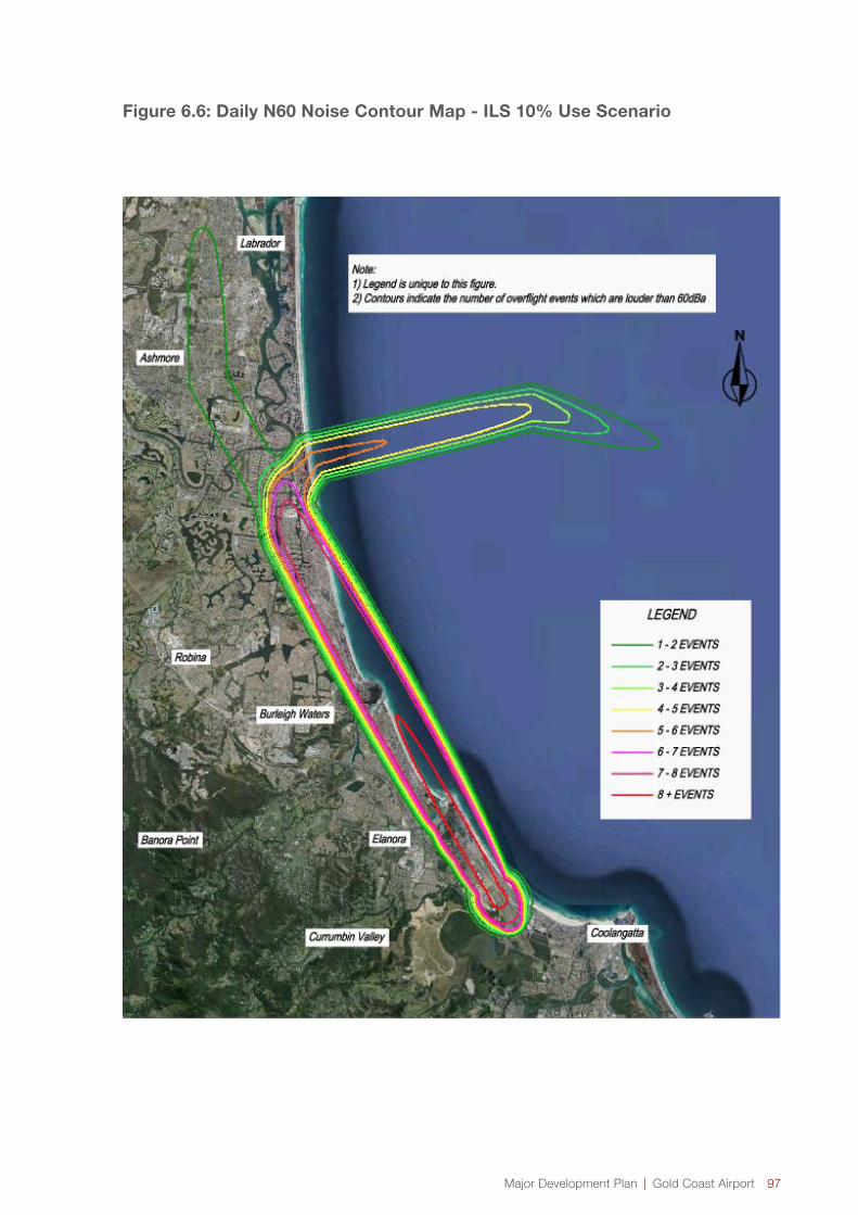
Major Development Plan | Gold Coast Airport 97
Figure 6.6: Daily N60 Noise Contour Map - ILS 10% Use Scenario
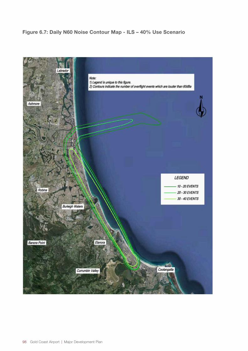
98 Gold Coast Airport | Major Development Plan
Figure 6.7: Daily N60 Noise Contour Map - ILS – 40% Use Scenario

Major Development Plan | Gold Coast Airport 99
Figure 6.8: Daily N60 Noise Contour Map – ILS 100% Use Scenario

100 Gold Coast Airport | Major Development Plan
Figure 6.9: Daily N70 Noise Contour Map - Current
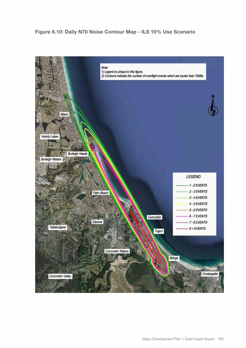
Major Development Plan | Gold Coast Airport 101
Figure 6.10: Daily N70 Noise Contour Map - ILS 10% Use Scenario
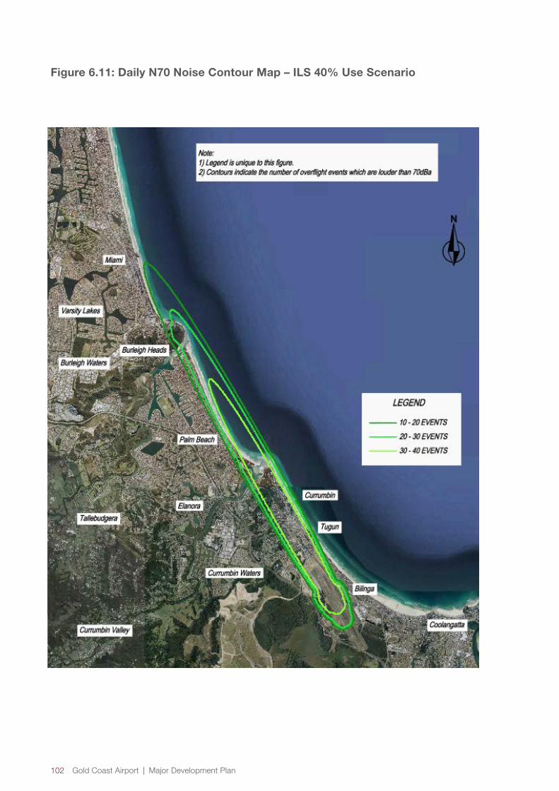
102 Gold Coast Airport | Major Development Plan
Figure 6.11: Daily N70 Noise Contour Map – ILS 40% Use Scenario

Major Development Plan | Gold Coast Airport 103
Figure 6.12: Daily N70 Noise Contour Map - ILS 100% Use Scenario

104 Gold Coast Airport | Major Development Plan
For comparative purposes the noise levels of everyday events are depicted in Figure 6.13:
Figure 6.13: Commonly Used Decibel Measurements for a Range of Everyday Noise Experiences
Dishwasher
55dB(A)
Conversation
60–65dB(A)
Passenger Car (60km/h at 7m distance) 70dB(A)
Noise Urban Area (daytime) 75dB(A)
Telephone Dial Tone 80dB(A)
City Traffic (inside car) 85dB(A)
Construction Site 90dB(A)
Diesel Truck (at 40km 7m away) 95dB(A)
Emergency Siren 140+dB(A)

Major Development Plan | Gold Coast Airport 105
6.2.2 Australian Noise Exposure Forecast Contours (ANEF)
The ANEF system is described in the Australian Standard AS2021 and is the only approved method of controlling land use planning at all but two Australian aerodromes. AS2021 provides guidance to regional, local authorities and others associated with urban and regional planning and building construction on the acceptable location of new buildings in relation to aircraft noise.
The ANEF system is not used to regulate aircraft operations, but rather to report on the effects of those activities. This system takes into account the frequency, intensity, time and duration of aircraft activities and calculates the total sound energy generated at any location. While ANEF contour charts are often misunderstood by the public at large, various expert committees that have considered the regulation of aircraft noise around Australian aerodromes have concluded that they are the most appropriate measure available. The only method of calculating ANEF contours is by use of the Integrated Noise Model (INM) developed by the Federal Aviation Agency of the USA. It cannot be directly measured. The INM calculates the aircraft noise exposure for an average day (averaged over a year) activity at an airport. For an ANEF this day is an average day of a complete year at the forecast date.
The Airports Act requires airport lessee companies to develop ANEF contour maps following consultation with operators and local government bodies in vicinity of the airport, for managing aircraft noise intrusion in areas of significant ANEF levels (i.e. above 30 ANEF). The 2011 Master Plan includes a 2031 Australian Noise Exposure Forecast (ANEF) for aircraft noise exposure based on the forecast number of aircraft movements and types of aircraft and of the assumed flight paths in the year 2031, being the 20 year planning horizon of the Master Plan.
The 2031 ANEF assumed that there would be an ILS approach on runway 14.The annual average noise from the ILS approach does not have any significant impact on ANEF levels over and above the impact of other approaches. As such, residential land use to the north of the airport within areas that are only overflown by aircraft using the ILS continues to be an acceptable land use under AS2021 by being within a zone less than 20 ANEF. This is indicated in Figure 6.14 being an extract from the 2011 Master Plan.
6.3 Noise Abatement
Civil Aviation Regulations allow pilots to request (and be granted) the type of landing arrangements they require to ensure safety is always given the highest priority. Airlines each have their own operating procedures on how to respond to deteriorating weather conditions, meaning that there will be different trigger points for when pilots will request an ILS approach based on such factors as to the rates at which the cloud base is descending and/or visibility is decreasing when approaching to land at the airport.
Through discussion with airlines, Airservices will work with the aviation industry to develop draft noise abatement procedures and expectations on how the ILS would be used. These noise abatement procedures will be discussed with the community, through the Community Aviation Consultation Group (CACG) with feedback considered within any required amendments prior to finalisation and the ILS becoming operational.
Noise abatement procedures have yet to be finalised for consultation with the airlines and the community. Noise abatement procedures will meet CASA requirements in regard to air safety and will be drafted with the purpose of minimising the frequency of usage and therefore noise from ILS operations into Gold Coast Airport. The basis of the noise abatement procedures will be that airlines will use alternate flight paths to the ILS to minimise noise when weather conditions and aircraft capability allow. The noise abatement procedures will prioritise approaches in the order of RNP approach, a visual approach and the ILS approach. There will however be occasions when the ILS is used by aircraft that are capable of flying the preferred approaches due to training and operational requirements. It is expected that noise abatement procedures will be finalised and published prior to commissioning of the ILS.

106 Gold Coast Airport | Major Development Plan
Figure 6.14: 2031 Australian Noise Exposure Forecast (ANEF)
GO
LD
CO
AS
T A
IRP
OR
T2
03
1 A
NE
F -
RU
NW
AY
UT
ILIS
AT
ION
TA
BL
E
Ru
nw
ay
14
Arr
iva
lsD
ep
art
ure
sC
irc
uit
sT
ota
lsD
ay
Nig
ht
Da
yN
igh
tD
ay
Nig
ht
Je
t A
ircra
ft7
47
40
03
.84
34
1.1
03
13
.68
01
1.2
66
39
.89
28
78
78
00
17
.65
14
5.0
66
01
6.9
01
75
.81
57
45
.43
47
A3
50
17
.65
14
5.0
66
01
6.9
01
75
.81
57
45
.43
47
73
78
00
7.3
13
42
.09
90
7.0
02
82
.40
96
18
.82
48
A3
21
23
7.3
13
42
.09
90
7.0
02
82
.40
96
18
.82
48
EM
B1
90
1.4
63
60
.43
72
1.3
68
50
.53
22
3.8
01
4G
IV0
.08
02
0.0
10
90
.08
02
0.0
10
90
.18
24
LE
AR
35
0.5
20
80
.13
85
0.5
20
80
.13
85
0.0
56
11
.37
47
CN
A5
10
0.1
30
20
.03
46
0.1
30
20
.03
46
0.3
29
6T
urb
o-p
rop
s0
.00
00
CN
A2
08
1.2
34
10
.58
07
1.2
34
10
.58
07
3.6
29
6B
EC
20
00
.81
63
0.1
11
30
.81
63
0.1
11
30
.01
40
1.8
69
2P
isto
nB
EC
58
P6
.31
06
0.1
75
45
.89
57
0.5
90
20
.33
15
0.0
33
21
3.3
36
6G
AS
EP
V1
.83
06
0.0
50
81
.83
06
0.0
50
80
.35
49
0.0
09
94
.12
76
GA
SE
PF
8.7
29
40
.53
75
8.7
29
40
.53
75
1.7
17
80
.10
58
20
.35
73
To
tals
74
.88
87
17
.50
98
72
.09
50
20
.30
35
2.4
74
30
.14
88
18
7.4
20
1
Ru
nw
ay
17
Arr
iva
lsD
ep
art
ure
sC
irc
uit
sT
ota
lsD
ay
Nig
ht
Da
yN
igh
tD
ay
Nig
ht
Turb
o-p
rop
sC
NA
20
80
.00
19
0.0
00
90
.00
28
Pis
ton
BE
C5
8P
0.0
05
50
.00
06
0.0
06
0G
AS
EP
V0
.02
00
0.0
00
60
.02
06
GA
SE
PF
0.1
22
80
.00
76
0.1
30
3
To
tals
0.1
50
20
.00
96
0.1
59
8
Ru
nw
ay
32
Arr
iva
lsD
ep
art
ure
sC
irc
uit
sT
ota
lsD
ay
Nig
ht
Da
yN
igh
tD
ay
Nig
ht
Je
t A
ircra
ft7
47
40
02
.16
19
0.6
20
52
.07
01
0.7
12
35
.56
47
78
78
00
9.9
28
92
.84
96
9.5
07
23
.27
13
25
.55
70
A3
50
9.9
28
92
.84
96
9.5
07
23
.27
13
25
.55
70
73
78
00
4.1
13
81
.18
07
3.9
39
11
.35
54
10
.58
89
A3
21
23
4.1
13
81
.18
07
3.9
39
11
.35
54
10
.58
89
EM
B1
90
0.8
23
30
.24
59
0.7
69
80
.29
94
2.1
38
3G
IV0
.04
51
0.0
06
20
.04
51
0.0
06
20
.10
26
LE
AR
35
0.2
93
00
.07
79
0.2
93
00
.07
79
0.0
31
60
.77
33
CN
A5
10
0.0
73
20
.01
95
0.0
73
20
.01
95
0.1
85
4T
urb
o-p
rop
sC
NA
20
80
.50
13
0.2
35
90
.69
22
0.3
25
81
.75
53
BE
C2
00
0.4
59
10
.06
26
0.4
59
10
.06
26
0.0
07
91
.05
14
Pis
ton
BE
C5
8P
3.4
81
30
.09
18
3.3
10
90
.33
15
0.1
86
50
.01
87
7.4
20
5G
AS
EP
V0
.88
67
0.0
24
61
.00
97
0.0
28
00
.19
96
0.0
05
52
.15
42
GA
SE
PF
4.4
05
60
.27
13
4.7
87
50
.29
48
0.9
66
30
.05
95
10
.78
49
To
tals
41
.21
60
9.7
16
64
0.4
03
31
1.4
11
11
.39
18
0.0
83
71
04
.22
24
Ru
nw
ay
35
Arr
iva
lsD
ep
art
ure
sC
irc
uit
sT
ota
lsD
ay
Nig
ht
Da
yN
igh
tD
ay
Nig
ht
Turb
o-p
rop
sC
NA
20
80
.19
28
0.0
90
70
.28
36
Pis
ton
BE
C5
8P
0.0
68
40
.00
69
0.0
75
3G
AS
EP
V0
.14
30
0.0
04
00
.14
70
GA
SE
PF
0.5
04
70
.03
11
0.5
35
7
To
tals
0.9
08
90
.13
26
1.0
41
6
He
lic
op
ter
Arr
iva
lsD
ep
art
ure
sC
irc
uit
sT
ota
ls
La
nd
ing
Sit
eD
ay
Nig
ht
Da
yN
igh
tD
ay
Nig
ht
He
lico
pte
rsR
22
4.2
54
50
.00
85
4.2
54
50
.00
85
8.5
26
0B
40
72
.58
80
0.4
53
12
.58
80
0.4
53
16
.08
22
To
tals
6.8
42
50
.46
17
6.8
42
50
.46
17
14
.60
82
We
ste
rnA
rriv
als
De
pa
rtu
res
Cir
cu
its
To
tals
Gra
ss
Are
aD
ay
Nig
ht
Da
yN
igh
tD
ay
Nig
ht
He
lico
pte
rsR
22
42
.90
58
0.0
86
04
2.9
91
8B
40
73
.82
83
0.6
70
34
.49
86
To
tals
46
.73
41
0.7
56
34
7.4
90
4
Gra
nd
To
tals
12
3.8
56
12
7.8
20
71
19
.49
09
32
.18
58
50
.60
03
0.9
88
83
54
.94
24
No
tes:
- T
his
table
repre
sents
INM
Flig
ht O
pera
tions (
circuit
opera
tions c
ounte
d a
s o
ne o
pera
tion)
- T
GO
and C
IR c
om
bin
ed for
Circuit
opera
tions
- A
com
ple
te li
st of F
light O
pera
tions p
er
indiv
idual f
light tr
ack
are
ava
ilable
in th
e a
ccom
panyi
ng R
eport
- T
here
are
som
e r
oundin
g e
rrors
as y
early
Flig
ht O
pera
tions a
re d
ivid
ed b
y 365 to g
ive d
aily
Flig
ht O
pera
tions
AS
20
21 -
TA
BL
E O
F B
UIL
DIN
G S
ITE
AC
CE
PT
AB
ILIT
Y B
AS
ED
ON
AN
EF
ZO
NE
S
BU
ILD
ING
TY
PE
A
NE
F Z
ON
E O
F S
ITE
AC
CE
PT
AB
LE
C
ON
DIT
ION
AL
U
NA
CC
EP
TA
BL
E
Ho
use
, h
om
e u
nit,
fla
t, c
ara
va
n p
ark
L
ess t
ha
n 2
0 A
NE
F
(No
te 1
of
AS
202
1)
20 t
o 2
5 A
NE
F
(No
te 2
of
AS
202
1)
Gre
ate
r th
an 2
5
AN
EF
Ho
tel, m
ote
l, h
oste
l L
ess t
ha
n 2
5 A
NE
F
25 t
o 3
0 A
NE
F
Gre
ate
r th
an 3
0
AN
EF
Sch
oo
l, u
niv
ers
ity
Less t
ha
n 2
0 A
NE
F
(No
te 1
of
AS
202
1)
20 t
o 2
5 A
NE
F
(No
te 2
of
AS
202
1)
Gre
ate
r th
an 2
5
AN
EF
Ho
sp
ita
l, n
urs
ing
h
om
e
Less t
ha
n 2
0 A
NE
F
(No
te 1
of
AS
202
1)
20 t
o 2
5 A
NE
F
Gre
ate
r th
an 2
5
AN
EF
Pu
blic
bu
ildin
g
Less t
ha
n 2
0 A
NE
F
(No
te 1
of
AS
202
1)
20 t
o 3
0 A
NE
F
Gre
ate
r th
an 3
0
AN
EF
Co
mm
erc
ial b
uild
ing
L
ess t
ha
n 2
5 A
NE
F
25 t
o 3
5 A
NE
F
Gre
ate
r th
an 3
5
AN
EF
Lig
ht in
du
str
ial
Less t
ha
n 3
0 A
NE
F
30 t
o 4
0 A
NE
F
Gre
ate
r th
an 4
0
AN
EF
Oth
er
ind
ustr
ial
Acce
pta
ble
in
all
AN
EF
zo
ne
s

Major Development Plan | Gold Coast Airport 107
6.3.1 Other Amelioration Measures
Airservices and Gold Coast Airport are committed to minimising the impacts of aircraft noise on communities, through the application of Noise Abatement Procedures (NAP), Letters of Agreement (LOA) outlining practices between air traffic control units controlling the airspace surrounding Gold Coast Airport, and Local Instructions (LI). As well as the noise abatement procedures discussed above, the following initiatives are being prepared by Airservices and GCAPL for the ILS:
→ An ongoing Community Relations Strategy, as detailed in Section 7 of this report.
→ Undertaking a noise monitoring program at locations determined through a community engagement process, and as agreed with the Community Aviation Consultation Group (CACG).
→ Informing the Aircraft Noise Ombudsman (ANO) of all proposed actions in respect of the ILS, and respond to advice or requested action in a timely manner.
→ Undertaking a post implementation review of the Environmental Assessment of the proposed flight paths associated with the ILS, not less than 12 months, and not more than 18 months following commissioning of the ILS, as detailed at the “Auditing of Compliance” section of the Environmental Assessment by Airservices (http://www.airservicesaustralia.com/projects/).
6.4 Noise and the Natural Environment
The Environmental Assessment undertaken by Airservices included a review of the natural environment and heritage associated with the noise impacts from the ILS. No matters of potential significance have been identified. This included reference to:
→ Habitat and ecosystem
→ Wetlands of International Importance (RAMSAR)
→ Threatened and/or vulnerable flora
→ Threatened and/or vulnerable fauna
→ World heritage matters
→ National heritage matters
→ Matters of indigenous cultural heritage
The DoE protected matters search tool was employed, and a detailed analysis was undertaken of potential bird strike issues. The analysis indicated the ILS has a negligible impact on an increased risk of bird strike.
The potential change in CO2 emissions as a result of implementing the ILS and associated air traffic management procedures has been assessed. The difference in CO2 emissions has been estimated based on the straight-line distance between Gold Coast Airport and the nearest suitable alternate, Brisbane Airport. Although there will be an increase in CO2 emissions due to the extra track miles associated with the ILS flight path, it is not considered this will consistute an environmental impact due to the relatively low frequency of aircraft using the ILS when compared to the total arrivals per year.
Detailed modelling of potential emissions changes for aircraft intercepting the ILS compared to the existing approach procedures has not been undertaken and is not practicable due to the differences in track miles each individual aircraft may fly when being vectored to intercept the final approach. It is estimated however that the levels of aircraft pollution associated with the ILS approach will be negligible in comparison with emissions from cars, trucks, industry, burn-offs and bushfires around Gold Coast.
Organisations including the World Health Organization and the International Civil Aviation Organization (ICAO) acknowledge the impacts of night-time noise on sleep, health and cognitive performance. In 1999 a night time curfew was introduced at Gold Coast Airport which limits the ground perceived exposure to aircraft noise during night hours. The curfew is in operation from 11pm to 6am daily and is regulated under the Air Navigation (Coolangatta Airport Curfew) Regulations 1999. It is noted that all areas in the ILS flight path are urban locations and are currently exposed to normal levels of urban ambient noise.
Chapter 5 comprehensively discusses a broader range of environmental matters.


Consultation7.0
110 Gold Coast Airport | Major Development Plan
7.1 Consultation Process
In developing a MDP, airports must publish a preliminary draft MDP and invite public comment. Consultation is to occur as required with state and local governments, airport stakeholders and the general public. Airservices and GCAPL will undertake public consultation on all elements of the proposal including flight paths and the associated noise impacts concurrently through MDP.
During preparation of the preliminary draft MDP, initial consultations have occurred with key agencies and other stakeholders.
During the 60 business day public comment period of the preliminary draft MDP, a much wider group of stakeholders and the general public were be engaged through a range of forums, publications, public notices etc.
GCAPL has considered the comments received and has prepared a draft MDP, with a supplementary report to the Minister for Infrastructure and Regional Development for a decision.
Airservices has also considered comments received for the flight path approval process. Feedback on all elements of the project have been captured through the formed MDP process.
The submitted information has been considered by the Minister.
Further details on the public consultation process is provided in Sections 7.2, 7.3, 7.4 and 7.5.
7.2 Commitment to Proactive Consultation
GCAPL is committed to ongoing and proactive communication and engagement with the local community. GCAPL has a number of key community forums in place and additionally presents updates to local community groups regularly. GCAPL maintains extensive public information on the Gold Coast Airport website relating to airport operations, activities and complaint handling processes. GCAPL also works closely with Airservices to monitor local aircraft noise complaints.
7.3 Consultation Prior to the Public Comment Period
GCAPL has engaged with a range of key stakeholders, including elected representatives and officers of local, state and Federal Government, industry, business and external consultancies in developing the preliminary draft MDP.
The focus of this engagement has been to:
→ Explain how the ILS will operate and its benefits;
→ Discuss and confirm the approach being taken by GCAPL and Airservices with the proposed implementation of an ILS;
→ Seek support for the ILS.
Specifically the stakeholders that have been consulted during this stage of development of the preliminary draft MDP have included:
→ Federal Department of Infrastructure and Regional Development
→ Federal Department of the Environment
→ New South Wales Department of Planning and Environment
→ New South Wales Roads and Maritime Services
→ New South Wales Crown Land
→ Federal Government Ministers and Members of Parliament:
» Karen Andrews – Federal Member for McPherson;
» Stephen Ciobo - Federal Member for Moncrief;
» Justine Elliott - Federal Member for Richmond.
→ Queensland State Government Ministers and Members of Parliament:
» Michael Hart – State Member for Burleigh;
» Jan Stuckey – State Member for Currumbin;
» Ray Stevens – State Member for Mermaid Beach;
» Ros Bates – State Member for Mudgeeraba;
» John-Paul Langbrook – State Member for Surfers Paradise;
» Rob Molhoek – State Member for Southport.
7.0 Consultation

Major Development Plan | Gold Coast Airport 111
→ New South Wales State Government Ministers and Members of Parliament:
» Geoff Provest – State Member for Tweed;
» George Souris – Former State Tourism Minister;
» Don Page – Former State Member for Ballina.
→ Tweed Shire Councillors;
→ City of Gold Coast Councillors;
→ Community Aviation Consultation Group;
→ Airport Noise Abatement Consultative Committee;
→ General Aviation Consultative Committee;
→ Tweed Heads Pony club;
→ Indigenous groups;
→ Airlines.
7.4 The Public Comment Period
The public comment period commenced on 20 April 2015 and concluded on 13 July 2015. During this time GCAPL and Airservices consulted with the following stake holders:
→ Federal Department of Infrastructure and Regional Development;
→ Federal Department of the Environment;
→ Queensland Government;
→ New South Wales Government;
→ City of Gold Coast Council;
→ Tweed Shire Council;
→ Federal members of parliament;
→ State members of parliament;
→ Local Councillors;
→ Airservices
→ Civil Aviation Safety Authority;
→ Airlines;
→ Industry groups;
→ Community groups
GCAPL and Airservices undertook a range of stakeholder engagement activities including:
→ Briefings with key stakeholders;
→ Staffed public information sessions;
→ Provision of preliminary draft MDP’s at Gold Coast Airport reception and at various locations, namely council libraries through hard copies (copies were also available for download from the Gold Coast Airport website);
→ Joint GCAPL and Airservices media releases and fact sheets;
→ Joint GCAPL and Airservices media briefings;
→ Provision of information on the Gold Coast Airport website and Facebook page;
→ Advertisements in local newspapers and community publications outlining both the community consultation period and advising of relevant forums and sessions that the community can attend to learn more;
→ Social Media
→ Mail drop to affected properties
→ Fielding of telephone enquiries
7.5 After The Public Comment Period
GCAPL has considered the comments received during the 60 business day public comment period and has revised the draft MDP and prepared a supplementary report to the Minister for Infrastructure and Regional Development for a decision. Airservices have also considered any comments received relating to the flight path and noise impacts. The supplementary report includes copies of all of the written public, government and other stakeholders’ comments/submissions with an explanation as to how the comments/submissions have been taken into account in finalising a draft MDP for submission to the Minister.
The Minister is required to reach a decision in accordance with the statutory time frames outlined in the Airports Act. If the Minister does not reach a decision within this time and after receiving all the necessary documents and information, the Minister is taken to have approved the draft MDP.
Should the Minister approve the draft MDP, a final MDP is required to be prepared within 50 business days which includes any amendments identified during the decision process.

Appendix ASpecies Likelihood of Occurrence Assessment
8.0
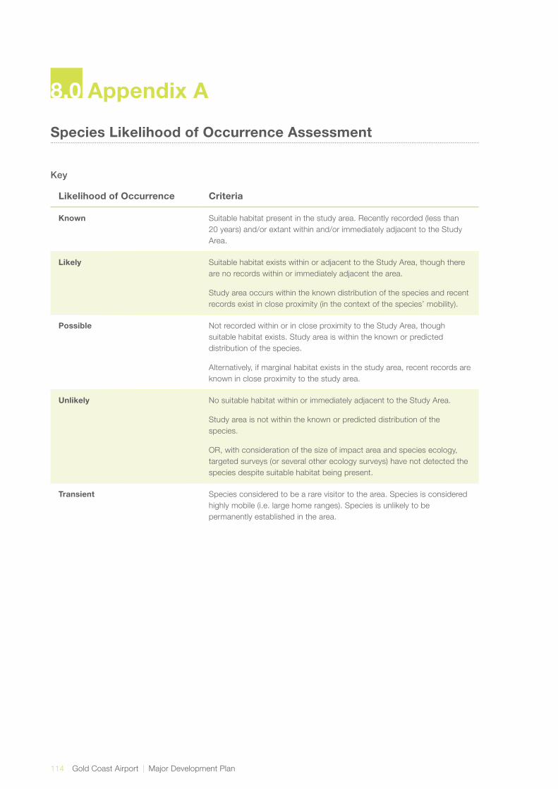
114 Gold Coast Airport | Major Development Plan
Species Likelihood of Occurrence Assessment
Key
Likelihood of Occurrence Criteria
Known Suitable habitat present in the study area. Recently recorded (less than 20 years) and/or extant within and/or immediately adjacent to the Study Area.
Likely Suitable habitat exists within or adjacent to the Study Area, though there are no records within or immediately adjacent the area.
Study area occurs within the known distribution of the species and recent records exist in close proximity (in the context of the species’ mobility).
Possible Not recorded within or in close proximity to the Study Area, though suitable habitat exists. Study area is within the known or predicted distribution of the species.
Alternatively, if marginal habitat exists in the study area, recent records are known in close proximity to the study area.
Unlikely No suitable habitat within or immediately adjacent to the Study Area.
Study area is not within the known or predicted distribution of the species.
OR, with consideration of the size of impact area and species ecology, targeted surveys (or several other ecology surveys) have not detected the species despite suitable habitat being present.
Transient Species considered to be a rare visitor to the area. Species is considered highly mobile (i.e. large home ranges). Species is unlikely to be permanently established in the area.
8.0 Appendix A
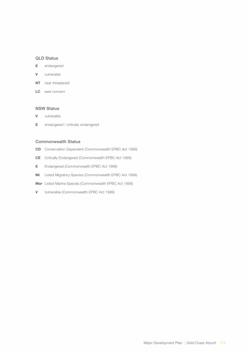
Major Development Plan | Gold Coast Airport 115
QLD Status
E endangered
V vulnerable
NT near threatened
LC east concern
NSW Status
V vulnerable
E endangered / critically endangered
Commonwealth Status
CD Conservation Dependent (Commonwealth EPBC Act 1999)
CE Critically Endangered (Commonwealth EPBC Act 1999)
E Endangered (Commonwealth EPBC Act 1999)
Mi Listed Migratory Species (Commonwealth EPBC Act 1999)
Mar Listed Marine Species (Commonwealth EPBC Act 1999)
V Vulnerable (Commonwealth EPBC Act 1999)

116 Gold Coast Airport | Major Development Plan
Kingdom Scientific Name Common Name Qld Status
NSW Status
Comm. status Type Preferred Habitat Known Distribution Reference Likelihood of Occurrence in
the Localiser FootprintLikelihood of Occurrence in the 300m Runway Strip
Plantae Acacia baueri subsp. Baueri
Tiny Wattle V Plant Acacia baueri subsp. baueri is found on infertile and often seasonally waterlogged sands in coastal heath (wallum) habitat and adjacent plateaus and low open woodland.
Unknown endemicity. Wetland Info (Qld) Not relevant, as this species is not listed as a significant species in NSW.
Possible – suitable habitat exists.
Animalia Actitis hypoleucos Common Sandpiper Ma, Mi Bird The species utilises a wide range of coastal wetlands and some inland wetlands, with varying levels of salinity, and is mostly found around muddy margins or rocky shores and rarely on mudflats. The Common Sandpiper has been recorded in estuaries and deltas of streams, as well as on banks farther upstream; around lakes, pools, billabongs, reservoirs, dams and claypans, and occasionally piers and jetties. The muddy margins utilised by the species are often narrow, and may be steep. The species is often associated with mangroves, and sometimes found in areas of mud littered with rocks or snag.
Found along all coastlines of Australia and in many areas inland.
SPRAT Possible - known to inhabit the Tweed River Estuary.
Unlikely - due to habitat preference.
Animalia Amaurornis olivaceus Bush-hen V Bird Occurs in a variety of coastal wetlands from mangroves, lagoons and swamps, to river margins and creeks running through rainforest. It has also been recorded away from water in dense low vegetation, including Bladey Grass and the introduced Lantana.
Coastal northern Australia and through eastern Queensland to the NSW north coast.
State Forests of NSW (1995); Pizzey & Knight(2003)
Likely – potential habitat occurs in the study area. Species previously recorded in vicinity of site.
Unlikely - no suitable habitat.
Animalia Anseranas semipalmata
Magpie Goose V Ma Bird Rush and sedge dominated swamps and floodplains.
Restricted to coastal areas of southern Queensland and northern NSW.
Pizzey & Knight(2003) Possible – potential habitat occurs in the study area.
Unlikely - no suitable habitat.
Animalia Apuspacificus Fork-tailed Swift Ma, Mi Bird In NSW, the Fork-tailed Swift is recorded in all regions. Many records occur east of the Great Divide.
They mostly occur over dry or open habitats, including riparian woodland and tea-tree swamps, low scrub, heathland or saltmarsh.
SPRAT Possible - though the Fork-tailed Swift is almost exclusively aerial.
Possible - though the Fork-tailed Swift is almost exclusively aerial.
Animalia Ardea ibis Cattle Egret Ma, Mi Bird Inhabits a variety of wetlands. Wide distribution throughout mainland Australia and Tasmania.
Pizzey & Knight(2003) Likely – potential habitat occurs in the study area. This species has been previously recorded as part of the Airport Bird Monitoring Program.
Likely – potential habitat occurs in the study area. This species has been previously recorded as part of the Airport Bird Monitoring Program.
Animalia Ardea modesta / alba
Eastern Great Egret Ma, Mi Bird Inhabits a variety of wetlands. Wide distribution throughout mainland Australia and Tasmania.
Pizzey & Knight(2003) Likely – potential habitat occurs in the study area.
Possible – potential habitat occurs in the study area.
Animalia Arenaria interpres Ruddy Turnstone Ma, Mi Bird In Australia, Ruddy Turnstones are widespread around the coast of the mainland and off-shore islands.
They are mainly found on exposed rocks or reefs, often with shallow pools, and on beaches. In the north, they are found in a wider range of habitats, including mudflats.
Birds in Backyards Possible - due to habitat preference. Not originally included in Maunsell|AECOM assessment (2007a). Known to inhabit the Tweed River Estuary.
Unlikely - no suitable habitat.
Plantae Blandfordia grandiflora
Christmas Bells E Plant Grows in damp sandy and/or peaty soils in coastal and tableland areas.
North from the Hawkesbury River area and inland to Glen Innes district.
National Herbarium of NSW
N/A - as this species is not considered significant in NSW.
Known to occur in one area within the 300m runway strip.
Animalia Botaurus poiciloptilus Australian Bittern E E Bird The Australasian Bittern requires shallow water, less than 30 cm deep with medium to low density reeds, grasses or shrubs for foraging. It needs deeper water with medium to high density reeds, rushes or sedges for nesting. It is largely recorded in freshwater wetlands and, rarely, in estuaries or tidal wetlands.
In Queensland, the bittern occurs in the far south-east; it has been reported north to Baralaba and west to Wyandra, although in most years it is probably confined to a few coastal swamps. Today, it is rarely recorded in Queensland, and possibly survives only in protected areas such as the Cooloola and Fraser regions.
SPRAT Unlikely - no suitable habitat present. Unlikely - no suitable habitat present.
Animalia Burhinus grallarius Bush Stone-curlew E Bird Open woodland with fallen branches, leaf litter, sparse grass and timber along water courses; sandy scrub near beaches and mangrove fringes.
Australia, general distribution. Pizzey, G. and Knight, F. (2003)
Likely – potential habitat occurs in the study area. This species has been previously recorded as part of the Airport Bird Monitoring Program.
Likely – potential habitat occurs in the study area. This species has been previously recorded as part of the Airport Bird Monitoring Program.
Animalia Calidris acuminata Sharp-tailed Sandpiper
Ma, Mi Bird Throughout Australia. The Sharp-tailed Sandpiper prefers the grassy edges of shallow inland freshwater wetlands. It is also found around sewage farms, flooded fields, mudflats, mangroves, rocky shores and beaches.
Birds in Backyards Likely – potential habitat occurs in the study area. Not originally included in Maunsell|AECOM assessment (2007a).
Unlikely - no suitable habitat.
Animalia Calidris alba Sanderling V Ma, Mi Bird Sanderlings occur around Australia, mainly along the northern and eastern coasts.
The Sanderling prefers open sandy beaches exposed to open sea-swell, exposed sandbars and spits.
NSW National Parks and Wildlife Service Threatened Species Information
Possible - known to inhabit the Tweed River Estuary.
Unlikely - no suitable habitat present.
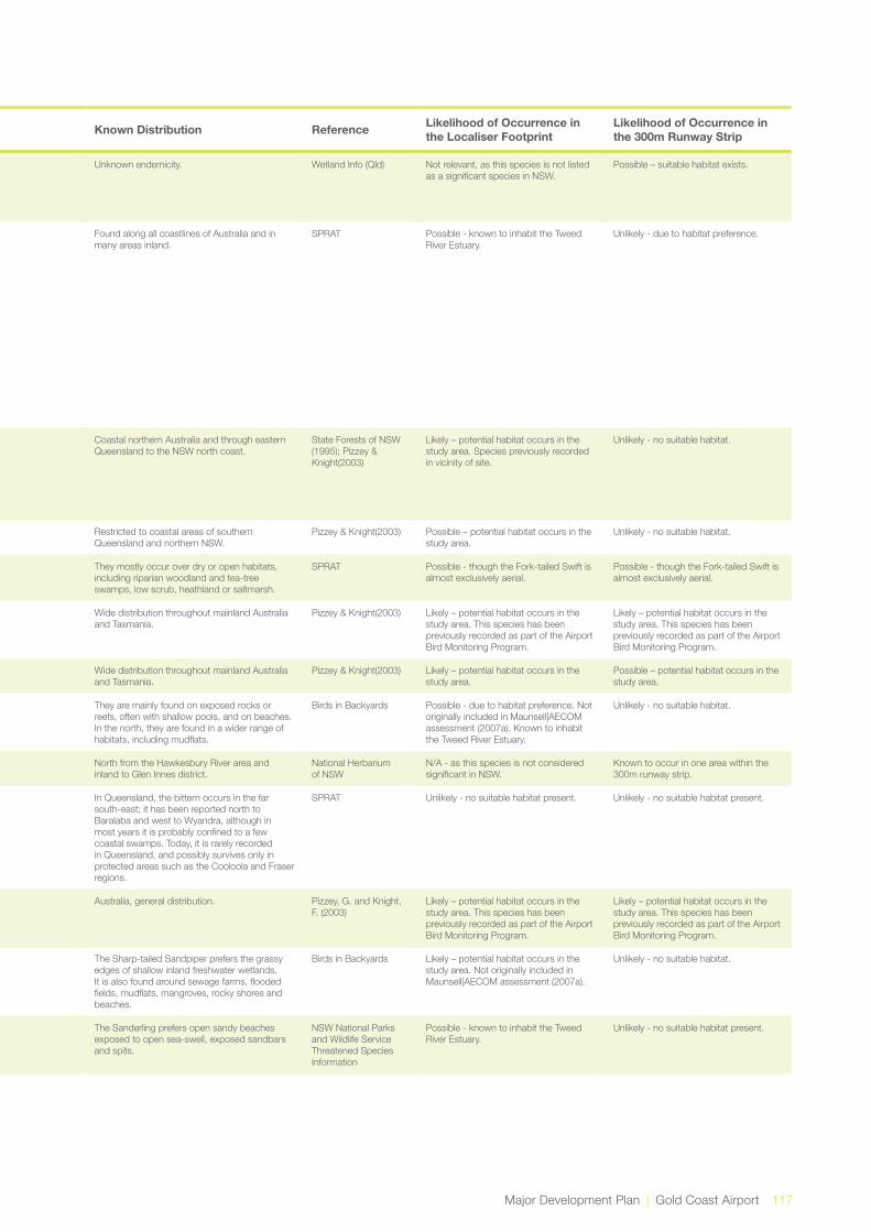
Major Development Plan | Gold Coast Airport 117
Kingdom Scientific Name Common Name Qld Status
NSW Status
Comm. status Type Preferred Habitat Known Distribution Reference Likelihood of Occurrence in
the Localiser FootprintLikelihood of Occurrence in the 300m Runway Strip
Plantae Acacia baueri subsp. Baueri
Tiny Wattle V Plant Acacia baueri subsp. baueri is found on infertile and often seasonally waterlogged sands in coastal heath (wallum) habitat and adjacent plateaus and low open woodland.
Unknown endemicity. Wetland Info (Qld) Not relevant, as this species is not listed as a significant species in NSW.
Possible – suitable habitat exists.
Animalia Actitis hypoleucos Common Sandpiper Ma, Mi Bird The species utilises a wide range of coastal wetlands and some inland wetlands, with varying levels of salinity, and is mostly found around muddy margins or rocky shores and rarely on mudflats. The Common Sandpiper has been recorded in estuaries and deltas of streams, as well as on banks farther upstream; around lakes, pools, billabongs, reservoirs, dams and claypans, and occasionally piers and jetties. The muddy margins utilised by the species are often narrow, and may be steep. The species is often associated with mangroves, and sometimes found in areas of mud littered with rocks or snag.
Found along all coastlines of Australia and in many areas inland.
SPRAT Possible - known to inhabit the Tweed River Estuary.
Unlikely - due to habitat preference.
Animalia Amaurornis olivaceus Bush-hen V Bird Occurs in a variety of coastal wetlands from mangroves, lagoons and swamps, to river margins and creeks running through rainforest. It has also been recorded away from water in dense low vegetation, including Bladey Grass and the introduced Lantana.
Coastal northern Australia and through eastern Queensland to the NSW north coast.
State Forests of NSW (1995); Pizzey & Knight(2003)
Likely – potential habitat occurs in the study area. Species previously recorded in vicinity of site.
Unlikely - no suitable habitat.
Animalia Anseranas semipalmata
Magpie Goose V Ma Bird Rush and sedge dominated swamps and floodplains.
Restricted to coastal areas of southern Queensland and northern NSW.
Pizzey & Knight(2003) Possible – potential habitat occurs in the study area.
Unlikely - no suitable habitat.
Animalia Apuspacificus Fork-tailed Swift Ma, Mi Bird In NSW, the Fork-tailed Swift is recorded in all regions. Many records occur east of the Great Divide.
They mostly occur over dry or open habitats, including riparian woodland and tea-tree swamps, low scrub, heathland or saltmarsh.
SPRAT Possible - though the Fork-tailed Swift is almost exclusively aerial.
Possible - though the Fork-tailed Swift is almost exclusively aerial.
Animalia Ardea ibis Cattle Egret Ma, Mi Bird Inhabits a variety of wetlands. Wide distribution throughout mainland Australia and Tasmania.
Pizzey & Knight(2003) Likely – potential habitat occurs in the study area. This species has been previously recorded as part of the Airport Bird Monitoring Program.
Likely – potential habitat occurs in the study area. This species has been previously recorded as part of the Airport Bird Monitoring Program.
Animalia Ardea modesta / alba
Eastern Great Egret Ma, Mi Bird Inhabits a variety of wetlands. Wide distribution throughout mainland Australia and Tasmania.
Pizzey & Knight(2003) Likely – potential habitat occurs in the study area.
Possible – potential habitat occurs in the study area.
Animalia Arenaria interpres Ruddy Turnstone Ma, Mi Bird In Australia, Ruddy Turnstones are widespread around the coast of the mainland and off-shore islands.
They are mainly found on exposed rocks or reefs, often with shallow pools, and on beaches. In the north, they are found in a wider range of habitats, including mudflats.
Birds in Backyards Possible - due to habitat preference. Not originally included in Maunsell|AECOM assessment (2007a). Known to inhabit the Tweed River Estuary.
Unlikely - no suitable habitat.
Plantae Blandfordia grandiflora
Christmas Bells E Plant Grows in damp sandy and/or peaty soils in coastal and tableland areas.
North from the Hawkesbury River area and inland to Glen Innes district.
National Herbarium of NSW
N/A - as this species is not considered significant in NSW.
Known to occur in one area within the 300m runway strip.
Animalia Botaurus poiciloptilus Australian Bittern E E Bird The Australasian Bittern requires shallow water, less than 30 cm deep with medium to low density reeds, grasses or shrubs for foraging. It needs deeper water with medium to high density reeds, rushes or sedges for nesting. It is largely recorded in freshwater wetlands and, rarely, in estuaries or tidal wetlands.
In Queensland, the bittern occurs in the far south-east; it has been reported north to Baralaba and west to Wyandra, although in most years it is probably confined to a few coastal swamps. Today, it is rarely recorded in Queensland, and possibly survives only in protected areas such as the Cooloola and Fraser regions.
SPRAT Unlikely - no suitable habitat present. Unlikely - no suitable habitat present.
Animalia Burhinus grallarius Bush Stone-curlew E Bird Open woodland with fallen branches, leaf litter, sparse grass and timber along water courses; sandy scrub near beaches and mangrove fringes.
Australia, general distribution. Pizzey, G. and Knight, F. (2003)
Likely – potential habitat occurs in the study area. This species has been previously recorded as part of the Airport Bird Monitoring Program.
Likely – potential habitat occurs in the study area. This species has been previously recorded as part of the Airport Bird Monitoring Program.
Animalia Calidris acuminata Sharp-tailed Sandpiper
Ma, Mi Bird Throughout Australia. The Sharp-tailed Sandpiper prefers the grassy edges of shallow inland freshwater wetlands. It is also found around sewage farms, flooded fields, mudflats, mangroves, rocky shores and beaches.
Birds in Backyards Likely – potential habitat occurs in the study area. Not originally included in Maunsell|AECOM assessment (2007a).
Unlikely - no suitable habitat.
Animalia Calidris alba Sanderling V Ma, Mi Bird Sanderlings occur around Australia, mainly along the northern and eastern coasts.
The Sanderling prefers open sandy beaches exposed to open sea-swell, exposed sandbars and spits.
NSW National Parks and Wildlife Service Threatened Species Information
Possible - known to inhabit the Tweed River Estuary.
Unlikely - no suitable habitat present.

118 Gold Coast Airport | Major Development Plan
Kingdom Scientific Name Common Name Qld Status
NSW Status
Comm. status Type Preferred Habitat Known Distribution Reference Likelihood of Occurrence in
the Localiser FootprintLikelihood of Occurrence in the 300m Runway Strip
Animalia Calidris canutus Red Knot Ma, Mi Bird In Australasia the Red Knot mainly inhabit intertidal mudflats, sandflats and sandy beaches of sheltered coasts, in estuaries, bays, inlets, lagoons and harbours; sometimes on sandy ocean beaches or shallow pools on exposed wave-cut rock platforms or coral reefs. They are occasionally seen on terrestrial saline wetlands near the coast, such as lakes, lagoons, pools and pans, and recorded on sewage ponds and saltworks, but rarely use freshwater swamps. They rarely use inland lakes or swamps.
Coastal areas. SPRAT Possible - known to inhabit the Tweed River Estuary.
Unlikely - no suitable habitat present.
Animalia Calidris ferruginea Curlew Sandpiper E Ma, Mi Bird Curlew Sandpipers mainly occur on intertidal mudflats in sheltered coastal areas, such as estuaries, bays, inlets and lagoons, and also around non-tidal swamps, lakes and lagoons near the coast, and ponds in saltworks and sewage farms. They are also recorded inland, though less often, including around ephemeral and permanent lakes, dams, waterholes and bore drains, usually with bare edges of mud or sand. They occur in both fresh and brackish waters. Occasionally they are recorded around floodwaters.
Coastal areas. Possible - known to inhabit the Tweed River Estuary.
Unlikely - no suitable habitat present.
Animalia Calidrisruficollis Red-necked Stint Ma, Mi Bird Found widely in Australia, except in the arid inland.
In Australia, Red-necked Stints are found on the coast, in sheltered inlets, bays, lagoons, estuaries, intertidal mudflats and protected sandy or coral-lined shores.
Birds in Backyards Likely – potential habitat occurs in the study area. Not originally included in Maunsell|AECOM assessment (2007a).
Unlikely - no suitable habitat.
Animalia Calidris tenuirostris Great Knot V Ma, Mi Bird Occurs within sheltered, coastal habitats containing large, intertidal mudflats or sandflats, including inlets, bays, harbours,estuaries and lagoons.
Recorded predominately in coastal areas throughout Australia, including the coastal islands of Tasmania.
Slater et al. (1992) Possible - known to inhabit the Tweed River Estuary.
Unlikely - no suitable habitat.
Animalia Calyptorhynchus lathami
Glossy Black-Cockatoo
V V Bird Lower rainfall drysclerophyll forest on flat ground containing Allocasuarina torulosa, A. verticillata or A.littoralis.
From central Queensland to Victoria. State Forests of NSW (1995); Pizzey & Knight(2003)
Likely – species recorded foraging adjacent to the study area.
Likely – species recorded foraging adjacent to the study area.
Animalia Carterornis leucotis White-eared Monarch
V Bird Rainforest margins and regrowth, sense scrubs along streams, paperbark forests, mangroves, adjacent eucalypt forests.
Coastal Mainland Australia and Tasmania. Pizzey and Knight 2003 Unlikely - no suitable habitat present. Unlikely - no suitable habitat present.
Animalia Chalinolobus nigrogriseus
Hoary Wattled Bat V Mammal In NSW the Hoary Wattled Bat occurs in dry open eucalypt forests, favouring forests dominated by Spotted Gum, boxes and ironbarks, and in healthy coastal forests where Red Bloodwood and Scribbly Gum are common.
Widely distributed across northern Australia although absent from the arid centre. In north east NSW it reaches the lower Clarence and Richmond River areas, extending from near Murwillumbah in the north, and in the south between Grafton and Coffs Harbour.
Churchill (1998) Unlikely – recorded throughout the locality, though limited habitat available in the localiser footprint.
Unlikely – recorded throughout the locality, though limited habitat available in the 300m runway strip.
Animalia Charadrius bicinctus Double-banded Plover
Ma, Mi Bird In Australia, the Double-banded Plover is found mainly on the east coast and in Tasmania.
The Double-banded Plover is found on littoral, estuarine and fresh or saline terrestrial wetlands and also saltmarsh, grasslands and pasture.
SPRAT Possible – due to habitat preference. Not originally included in Maunsell|AECOM assessment (2007a). Known to inhabit the Tweed River Estuary.
Possible – due to habitat preference. Not originally included in Maunsell|AECOM assessment (2007a). Known to inhabit the Tweed River Estuary.
Animalia Charadrius leschenaultii
Greater Sand-plover V Ma, Mi Bird Almost entirely restricted to coastal areas in NSW, occurring mainly on sheltered sandy, shelly or muddy beaches or estuaries with large intertidal mudflats or sandbanks.
The species is apparently rare on the east coast, being found usually singularly. In NSW, the species has been recorded between the northern rivers and the Illawarra, with most records coming from the Clarence and Richmond estuaries.
Pizzey, G. and Knight, F. (2003)
Possible - known to enhabit the Tweed River Estuary.
Unlikely - no suitable habitat.
Animalia Charadrius mongolus Lesser Sand-plover V Ma, Mi Bird The Lesser Sand Plover breeds in eastern Siberia, southern Mongolia, western China and the Himalayas. The species then migrates to the coasts of eastern and southern Africa, the Middle East, India, South-East Asia and Australia.
In Australia, the species is known to favour coastal environments including beaches, mudflats and mangroves.
NSW National Parks and Wildlife Service Threatened Species Information; Pringle (1987)
Possible - known to enhabit the Tweed River Estuary.
Unlikely - no suitable habitat.
Animalia Crinia tinnula Wallum Froglet V V Amphibian Wallum Froglets are found only in acid paperbark swamps and sedge swamps of the coastal ‘wallum’ country.
Wallum Froglets are found only in acid paperbark swamps and sedge swamps of the coastal ‘wallum’ country.
Barker et al.(1995) Maunsell|AECOM (2007a) states that there is a high probability that Crinia tinnia exists in the localiser footprint because it is known to occur throughout the area. However, Ecosure (2009c) and the current study predicts that there is a low probability due to the lack of suitable habitat.
Likely - known to occur in the area.

Major Development Plan | Gold Coast Airport 119
Kingdom Scientific Name Common Name Qld Status
NSW Status
Comm. status Type Preferred Habitat Known Distribution Reference Likelihood of Occurrence in
the Localiser FootprintLikelihood of Occurrence in the 300m Runway Strip
Animalia Calidris canutus Red Knot Ma, Mi Bird In Australasia the Red Knot mainly inhabit intertidal mudflats, sandflats and sandy beaches of sheltered coasts, in estuaries, bays, inlets, lagoons and harbours; sometimes on sandy ocean beaches or shallow pools on exposed wave-cut rock platforms or coral reefs. They are occasionally seen on terrestrial saline wetlands near the coast, such as lakes, lagoons, pools and pans, and recorded on sewage ponds and saltworks, but rarely use freshwater swamps. They rarely use inland lakes or swamps.
Coastal areas. SPRAT Possible - known to inhabit the Tweed River Estuary.
Unlikely - no suitable habitat present.
Animalia Calidris ferruginea Curlew Sandpiper E Ma, Mi Bird Curlew Sandpipers mainly occur on intertidal mudflats in sheltered coastal areas, such as estuaries, bays, inlets and lagoons, and also around non-tidal swamps, lakes and lagoons near the coast, and ponds in saltworks and sewage farms. They are also recorded inland, though less often, including around ephemeral and permanent lakes, dams, waterholes and bore drains, usually with bare edges of mud or sand. They occur in both fresh and brackish waters. Occasionally they are recorded around floodwaters.
Coastal areas. Possible - known to inhabit the Tweed River Estuary.
Unlikely - no suitable habitat present.
Animalia Calidrisruficollis Red-necked Stint Ma, Mi Bird Found widely in Australia, except in the arid inland.
In Australia, Red-necked Stints are found on the coast, in sheltered inlets, bays, lagoons, estuaries, intertidal mudflats and protected sandy or coral-lined shores.
Birds in Backyards Likely – potential habitat occurs in the study area. Not originally included in Maunsell|AECOM assessment (2007a).
Unlikely - no suitable habitat.
Animalia Calidris tenuirostris Great Knot V Ma, Mi Bird Occurs within sheltered, coastal habitats containing large, intertidal mudflats or sandflats, including inlets, bays, harbours,estuaries and lagoons.
Recorded predominately in coastal areas throughout Australia, including the coastal islands of Tasmania.
Slater et al. (1992) Possible - known to inhabit the Tweed River Estuary.
Unlikely - no suitable habitat.
Animalia Calyptorhynchus lathami
Glossy Black-Cockatoo
V V Bird Lower rainfall drysclerophyll forest on flat ground containing Allocasuarina torulosa, A. verticillata or A.littoralis.
From central Queensland to Victoria. State Forests of NSW (1995); Pizzey & Knight(2003)
Likely – species recorded foraging adjacent to the study area.
Likely – species recorded foraging adjacent to the study area.
Animalia Carterornis leucotis White-eared Monarch
V Bird Rainforest margins and regrowth, sense scrubs along streams, paperbark forests, mangroves, adjacent eucalypt forests.
Coastal Mainland Australia and Tasmania. Pizzey and Knight 2003 Unlikely - no suitable habitat present. Unlikely - no suitable habitat present.
Animalia Chalinolobus nigrogriseus
Hoary Wattled Bat V Mammal In NSW the Hoary Wattled Bat occurs in dry open eucalypt forests, favouring forests dominated by Spotted Gum, boxes and ironbarks, and in healthy coastal forests where Red Bloodwood and Scribbly Gum are common.
Widely distributed across northern Australia although absent from the arid centre. In north east NSW it reaches the lower Clarence and Richmond River areas, extending from near Murwillumbah in the north, and in the south between Grafton and Coffs Harbour.
Churchill (1998) Unlikely – recorded throughout the locality, though limited habitat available in the localiser footprint.
Unlikely – recorded throughout the locality, though limited habitat available in the 300m runway strip.
Animalia Charadrius bicinctus Double-banded Plover
Ma, Mi Bird In Australia, the Double-banded Plover is found mainly on the east coast and in Tasmania.
The Double-banded Plover is found on littoral, estuarine and fresh or saline terrestrial wetlands and also saltmarsh, grasslands and pasture.
SPRAT Possible – due to habitat preference. Not originally included in Maunsell|AECOM assessment (2007a). Known to inhabit the Tweed River Estuary.
Possible – due to habitat preference. Not originally included in Maunsell|AECOM assessment (2007a). Known to inhabit the Tweed River Estuary.
Animalia Charadrius leschenaultii
Greater Sand-plover V Ma, Mi Bird Almost entirely restricted to coastal areas in NSW, occurring mainly on sheltered sandy, shelly or muddy beaches or estuaries with large intertidal mudflats or sandbanks.
The species is apparently rare on the east coast, being found usually singularly. In NSW, the species has been recorded between the northern rivers and the Illawarra, with most records coming from the Clarence and Richmond estuaries.
Pizzey, G. and Knight, F. (2003)
Possible - known to enhabit the Tweed River Estuary.
Unlikely - no suitable habitat.
Animalia Charadrius mongolus Lesser Sand-plover V Ma, Mi Bird The Lesser Sand Plover breeds in eastern Siberia, southern Mongolia, western China and the Himalayas. The species then migrates to the coasts of eastern and southern Africa, the Middle East, India, South-East Asia and Australia.
In Australia, the species is known to favour coastal environments including beaches, mudflats and mangroves.
NSW National Parks and Wildlife Service Threatened Species Information; Pringle (1987)
Possible - known to enhabit the Tweed River Estuary.
Unlikely - no suitable habitat.
Animalia Crinia tinnula Wallum Froglet V V Amphibian Wallum Froglets are found only in acid paperbark swamps and sedge swamps of the coastal ‘wallum’ country.
Wallum Froglets are found only in acid paperbark swamps and sedge swamps of the coastal ‘wallum’ country.
Barker et al.(1995) Maunsell|AECOM (2007a) states that there is a high probability that Crinia tinnia exists in the localiser footprint because it is known to occur throughout the area. However, Ecosure (2009c) and the current study predicts that there is a low probability due to the lack of suitable habitat.
Likely - known to occur in the area.

120 Gold Coast Airport | Major Development Plan
Kingdom Scientific Name Common Name Qld Status
NSW Status
Comm. status Type Preferred Habitat Known Distribution Reference Likelihood of Occurrence in
the Localiser FootprintLikelihood of Occurrence in the 300m Runway Strip
Plantae Cryptostylis hunteriana
Leafless tongue orchid
V V Plant The Leafless Tongue Orchid has been recorded from as far north as Gibraltar Range National Park south into Victoria around the coast as far as Orbost.
Does not appear to have well defined habitat preferences and is known to inhabit a range of communities, including swamp-heath and woodland.
SPRAT Unlikely - not included in previous studies but returned in Protected Matters Search Results.
Unlikely - not included in previous studies but returned in Protected Matters Search Results.
Dasyurus hallucatus Northern Quoll Mammal Queensland and the top end. The Northern Quoll occupies a diversity of habitats across its range which includes rocky areas, eucalypt forest and woodlands, rainforests, sandy lowlands and beaches, shrubland, grasslands and desert.
SPRAT Unlikely - not within known distribution. Not originally included in Maunsell|AECOM assessment.
Unlikely due to species distribution.
Animalia Dasyurus maculatus Spotted-tailed Quoll V E Mammal Primarily occurs in rainforest and wet sclerophyll forest.
South eastern Queensland through New South Wales to Victoria.
SPRAT Unlikely. Given large home ranges required and residential and infrastructure development surrounding the Airport.
Unlikely. Given large home ranges required and residential and infrastructure development surrounding the Airport.
Plantae Dendrobium melaleucaphilum
Spider orchid E Plant Occurs in coastal districts and nearby ranges, extending from Queensland to its southern distributional limit in the lower Blue Mountains.
Grows frequently on Melaleuca styphelioides, less commonly on rainforest trees or on rocks in coastal districts; north from the lower Blue Mtns.
Unlikely Unlikely.
Animalia Diomedea epomophora epomophora
Southern Royal Albatross
V, Mi, Ma Bird The Southern Royal Albatross is marine and pelagic. It occurs in subantarctic, subtropical and occasionally Antarctic waters.
During the non-breeding season, the Southern Royal Albatross has a wide and possibly circumpolar distribution, ranging north to about 35°S.
SPRAT Unlikely - no suitable habitat present. Unlikely - no suitable habitat present.
Animalia Diomedea exulans (sensu lato)
Wandering Albatross V E V, Mi, Ma Bird The Wandering Albatross is marine, pelagic and aerial.
The Wandering Albatross breeds on Macquarie Island. It feeds in Australian portions of the Southern Ocean.
SPRAT Unlikely - no suitable habitat present. Unlikely - no suitable habitat present.
Animalia Diomedea exulans antipodensis
Antipodean Albatross
V V V, Mi, Ma Bird The Antipodean Albatross is marine, pelagic and aerial.
The Antipodean Albatross is endemic to New Zealand, however forages widely in open water in the south-west Pacific Ocean, Southern Ocean and the Tasman Sea, notably off the coast of NSW.
SPRAT Unlikely - no suitable habitat present. Unlikely - no suitable habitat present.
Animalia Diomedea exulans exulans
Tristan Albatross E, Mi, Ma Bird Tristan Albatross occurs in a single population which breeds on Inaccessible Island and Gough Island in the Atlantic Ocean. The ‘at sea’ distribution of this newly described species is yet to be defined. There is currently only one definitive record of the Tristan Albatross from Australian waters. A bird banded as a chick on Gough Island was recaptured four years later off Wollongong.
The Tristan Albatross is a marine, pelagic seabird.
SPRAT Unlikely - no suitable habitat present. Unlikely - no suitable habitat present.
Animalia Diomedea exulans gibsoni
Gibson’s Albatross V V V, Mi, Ma Bird Gibson’s Albatross is marine, pelagic and aerial.
In Australian territory, Gibson’s Albatross has been recorded foraging between Coffs Harbour, NSW, and Wilson’s Promontory, Victoria.
SPRAT Unlikely - no suitable habitat present. Unlikely - no suitable habitat present.
Plantae Diploglottis campbellii
Small-leaved Tamarind
E E E Plant D.campbellii is currently known from 14 locations within an area from the coastal lowlands of the Richmond River on the far north coast of NSW, to the Nerang River on the Gold Coast of Queensland.
Rainforest. NSW DEH Unlikely - due to habitat preference. Included here as it was returned in Protected Matters Search Results.
Unlikely - due to habitat preference. Included here as it was returned in Protected Matters Search Results.
Plantae Drynaria rigidula Basket Fern E Plant In NSW, it is only found north of the Clarence River, in a few locations at Maclean, Bogangar, Byron Bay, Mullumbimby, in the Tweed Valley and at Woodenbong.
Usually found in rainforest but also in moist eucalypt and Swamp Oak forest.
NSW DEH Unlikely - not included in Ecosure (2009c) or Maunsel|AECOM Assessment (2007a).
Unlikely - not included in previous studies.
Plantae Durringtonia paludosa
Durringtonia NT Plant Grows in closed sedgeland communities in coastal swamps.
North from Laurieton, NSW. National Herbarium of NSW
Not relevant, as this species is not listed as a significant species in NSW.
Unlikely - limited available habitat.
Plantae Elyonurus citreus Lemon-scented Grass
E Plant Lemon-scented Grass grows in sandy soils near rivers or along the coast in wallum areas or sand dunes. At the NSW locations, the species has been found growing in infertile white sands.
Lemon-scented Grass occurs north from Grafton in NSW. It is only known from localities south of Casino, north-west of Grafton, near Cudgen Lake on the Tweed coast and in Yuraygir National Park. It also occurs in Queensland, NT, WA and New Guinea.
NSW National Parks and Wildlife Service Threatened Species Information; Pringle (1987)
Unlikely. Possible - Suitable habitat exists.
Animalia Ephippiorhynchus asiaticus
Black-necked Stork NT E Bird Inhabits riverine swamps, large permanent pools and coastal wetlands and estuaries.
Coastal and sub-coastal northern Australia from Port Headland (WA) to the central coast of NSW.
Blakers et al.(1984) Likely – potential habitat occurs in the study area. This species has been previously recorded as part of the Airport Bird Monitoring Program.
Likely – potential habitat occurs in the study area. This species has been previously recorded as part of the Airport Bird Monitoring Program and has been recorded in the 300m runway strip.
Animalia Erythrotriorchis radiatus
Red Goshawk E V Bird The Red Goshawk occurs in coastal and sub-coastal areas in wooded and forested lands of tropical and warm-temperate Australia.
Riverine forests are also used frequently. Such habitats typically support high bird numbers and biodiversity, especially medium to large species which the goshawk requires for prey.
SPRAT Unlikely (though not included in original assessment by Maunsell|AECOM).
Transient. Right at southern end of its range and substantial suitable habitat does not occur. Likely to be foraging habitat only.
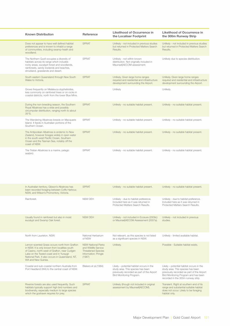
Major Development Plan | Gold Coast Airport 121
Kingdom Scientific Name Common Name Qld Status
NSW Status
Comm. status Type Preferred Habitat Known Distribution Reference Likelihood of Occurrence in
the Localiser FootprintLikelihood of Occurrence in the 300m Runway Strip
Plantae Cryptostylis hunteriana
Leafless tongue orchid
V V Plant The Leafless Tongue Orchid has been recorded from as far north as Gibraltar Range National Park south into Victoria around the coast as far as Orbost.
Does not appear to have well defined habitat preferences and is known to inhabit a range of communities, including swamp-heath and woodland.
SPRAT Unlikely - not included in previous studies but returned in Protected Matters Search Results.
Unlikely - not included in previous studies but returned in Protected Matters Search Results.
Dasyurus hallucatus Northern Quoll Mammal Queensland and the top end. The Northern Quoll occupies a diversity of habitats across its range which includes rocky areas, eucalypt forest and woodlands, rainforests, sandy lowlands and beaches, shrubland, grasslands and desert.
SPRAT Unlikely - not within known distribution. Not originally included in Maunsell|AECOM assessment.
Unlikely due to species distribution.
Animalia Dasyurus maculatus Spotted-tailed Quoll V E Mammal Primarily occurs in rainforest and wet sclerophyll forest.
South eastern Queensland through New South Wales to Victoria.
SPRAT Unlikely. Given large home ranges required and residential and infrastructure development surrounding the Airport.
Unlikely. Given large home ranges required and residential and infrastructure development surrounding the Airport.
Plantae Dendrobium melaleucaphilum
Spider orchid E Plant Occurs in coastal districts and nearby ranges, extending from Queensland to its southern distributional limit in the lower Blue Mountains.
Grows frequently on Melaleuca styphelioides, less commonly on rainforest trees or on rocks in coastal districts; north from the lower Blue Mtns.
Unlikely Unlikely.
Animalia Diomedea epomophora epomophora
Southern Royal Albatross
V, Mi, Ma Bird The Southern Royal Albatross is marine and pelagic. It occurs in subantarctic, subtropical and occasionally Antarctic waters.
During the non-breeding season, the Southern Royal Albatross has a wide and possibly circumpolar distribution, ranging north to about 35°S.
SPRAT Unlikely - no suitable habitat present. Unlikely - no suitable habitat present.
Animalia Diomedea exulans (sensu lato)
Wandering Albatross V E V, Mi, Ma Bird The Wandering Albatross is marine, pelagic and aerial.
The Wandering Albatross breeds on Macquarie Island. It feeds in Australian portions of the Southern Ocean.
SPRAT Unlikely - no suitable habitat present. Unlikely - no suitable habitat present.
Animalia Diomedea exulans antipodensis
Antipodean Albatross
V V V, Mi, Ma Bird The Antipodean Albatross is marine, pelagic and aerial.
The Antipodean Albatross is endemic to New Zealand, however forages widely in open water in the south-west Pacific Ocean, Southern Ocean and the Tasman Sea, notably off the coast of NSW.
SPRAT Unlikely - no suitable habitat present. Unlikely - no suitable habitat present.
Animalia Diomedea exulans exulans
Tristan Albatross E, Mi, Ma Bird Tristan Albatross occurs in a single population which breeds on Inaccessible Island and Gough Island in the Atlantic Ocean. The ‘at sea’ distribution of this newly described species is yet to be defined. There is currently only one definitive record of the Tristan Albatross from Australian waters. A bird banded as a chick on Gough Island was recaptured four years later off Wollongong.
The Tristan Albatross is a marine, pelagic seabird.
SPRAT Unlikely - no suitable habitat present. Unlikely - no suitable habitat present.
Animalia Diomedea exulans gibsoni
Gibson’s Albatross V V V, Mi, Ma Bird Gibson’s Albatross is marine, pelagic and aerial.
In Australian territory, Gibson’s Albatross has been recorded foraging between Coffs Harbour, NSW, and Wilson’s Promontory, Victoria.
SPRAT Unlikely - no suitable habitat present. Unlikely - no suitable habitat present.
Plantae Diploglottis campbellii
Small-leaved Tamarind
E E E Plant D.campbellii is currently known from 14 locations within an area from the coastal lowlands of the Richmond River on the far north coast of NSW, to the Nerang River on the Gold Coast of Queensland.
Rainforest. NSW DEH Unlikely - due to habitat preference. Included here as it was returned in Protected Matters Search Results.
Unlikely - due to habitat preference. Included here as it was returned in Protected Matters Search Results.
Plantae Drynaria rigidula Basket Fern E Plant In NSW, it is only found north of the Clarence River, in a few locations at Maclean, Bogangar, Byron Bay, Mullumbimby, in the Tweed Valley and at Woodenbong.
Usually found in rainforest but also in moist eucalypt and Swamp Oak forest.
NSW DEH Unlikely - not included in Ecosure (2009c) or Maunsel|AECOM Assessment (2007a).
Unlikely - not included in previous studies.
Plantae Durringtonia paludosa
Durringtonia NT Plant Grows in closed sedgeland communities in coastal swamps.
North from Laurieton, NSW. National Herbarium of NSW
Not relevant, as this species is not listed as a significant species in NSW.
Unlikely - limited available habitat.
Plantae Elyonurus citreus Lemon-scented Grass
E Plant Lemon-scented Grass grows in sandy soils near rivers or along the coast in wallum areas or sand dunes. At the NSW locations, the species has been found growing in infertile white sands.
Lemon-scented Grass occurs north from Grafton in NSW. It is only known from localities south of Casino, north-west of Grafton, near Cudgen Lake on the Tweed coast and in Yuraygir National Park. It also occurs in Queensland, NT, WA and New Guinea.
NSW National Parks and Wildlife Service Threatened Species Information; Pringle (1987)
Unlikely. Possible - Suitable habitat exists.
Animalia Ephippiorhynchus asiaticus
Black-necked Stork NT E Bird Inhabits riverine swamps, large permanent pools and coastal wetlands and estuaries.
Coastal and sub-coastal northern Australia from Port Headland (WA) to the central coast of NSW.
Blakers et al.(1984) Likely – potential habitat occurs in the study area. This species has been previously recorded as part of the Airport Bird Monitoring Program.
Likely – potential habitat occurs in the study area. This species has been previously recorded as part of the Airport Bird Monitoring Program and has been recorded in the 300m runway strip.
Animalia Erythrotriorchis radiatus
Red Goshawk E V Bird The Red Goshawk occurs in coastal and sub-coastal areas in wooded and forested lands of tropical and warm-temperate Australia.
Riverine forests are also used frequently. Such habitats typically support high bird numbers and biodiversity, especially medium to large species which the goshawk requires for prey.
SPRAT Unlikely (though not included in original assessment by Maunsell|AECOM).
Transient. Right at southern end of its range and substantial suitable habitat does not occur. Likely to be foraging habitat only.
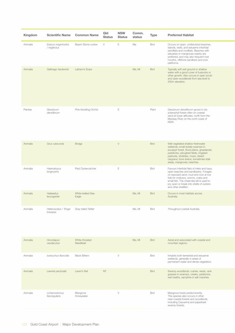
122 Gold Coast Airport | Major Development Plan
Kingdom Scientific Name Common Name Qld Status
NSW Status
Comm. status Type Preferred Habitat Known Distribution Reference Likelihood of Occurrence in
the Localiser FootprintLikelihood of Occurrence in the 300m Runway Strip
Animalia Esacus magnirostris / neglectus
Beach Stone-curlew V E Ma Bird Occurs on open, undisturbed beaches, islands, reefs, and estuarine intertidal sandflats and mudflats. Beaches with estuaries or mangroves nearby are preferred, and may also frequent river mouths, offshore sandbars and rock platforms.
Mainly between mid-north Western Australia and north-east NSW.
Slater et al. (1992) Unlikely - limited suitable habitat. Unlikely - no suitable habitat present.
Animalia Gallinago hardwickii Latham’s Snipe Ma, Mi Bird Typically soft wet ground or shallow water with a good cover of tussocks or other growth. Also occurs in open scrub and open woodlands from sea level to 200m elevation.
Mostly coastal from the Darling Downs, south east Queensland,and southern NSW.
Pizzey, G. and Knight, F. (2003); Avisure, pers. comm.
Known – potential habitat occurs in the study area. This species has been previously recorded as part of the Airport Bird Monitoring Program. Avisure has advised that this species has been recorded on monthly surveys every year except 2010 and can usually be found in the drains and wet wheel ruts adjacent to the northern end of Coolangatta Creek between September and May. This species is known to inhabit the Tweed River Estuary.
Known– potential habitat occurs in the study area. This species has been previously recorded as part of the Airport Bird Monitoring Program. Avisure has advised that this species has been recorded on monthly surveys every year except 2010 and can usually be found in the drains and wet wheel ruts adjacent to the northern end of Coolangatta Creek between September and May.
Plantae Geodorum densiflorum
Pink Nodding Orchid E Plant Geodorumdensiflorumgrows in dry sclerophyll forest often on coastal sand at lower altitudes, north from the Macleay River on the north coast of NSW.
There are thought to be fewer than 10 populations of Geodorumdensiflorum in NSW. The largest known population has been estimated to have about 200 plants, with other populations thought to be smaller in plant numbers. One population is reserved in Cudgen Nature Reserve, and one has been recorded from Bundjalung National Park, but the status of the Bundjalung population is unknown.
NSW DEH species profile
This was assessed as a moderate likelihood by Maunsell|AECOM (2007a), and a low likelihood by Ecosure (2009c). This assessment agrees with Maunsell|AECOM due to the suitability of habitat in the small triangle of land to the east. It is noteworthy that this species has not been identified during the previous two field surveys, though sometimes the species is inconspicuous.
Possible - Suitable habitat exists.
Animalia Grus rubicunda Brolga V Bird Well vegetated shallow freshwater wetlands; small isolate swamps in eucalypt forest, flood plains, grasslands; paddocks, ploughed fields, irrigated pastures, stubbles, crops; desert claypans; bore drains; sometimes tidal areas, mangroves, beaches.
North and eastern Australia. Now sparse, uncommon or rare.
Pizzey, G. and Knight, F. (2003);
Possible - Suitable habitat present, though probably an uncommon visitor. This species has been previously recorded in the Cobaki.
Possible - Suitable habitat present, though probably an uncommon visitor. This species has been previously recorded in the Cobaki.
Animalia Haematopus longirostris
Pied Oystercatcher E Bird Favours intertidal flats of inlets and bays, open beaches and sandbanks. Forages on exposed sand, mud and rock at low tide for molluscs, worms, crabs and small fish. The chisel-like bill is used to pry open or break into shells of oysters and other shellfish.
Distributed around the entire Australian coastline, although it is most common in coastal Tasmania and parts of Victoria, such as Corner Inlet. In NSW the species is thinly scattered along the entire coast.
Simpson and Day (1993)
Unlikely - no suitable habitat present. Unlikely - no suitable habitat present.
Animalia Haliaeetus leucogaster
White-bellied Sea-Eagle
Ma, Mi Bird Occurs in most habitats across Australia.
Widely distributed across Australian mainland and Tasmania.
Slater et al. (1992) Likely – potential habitat occurs in the study area. This species has been previously recorded as part of the Airport Bird Monitoring Program.
Likely – potential habitat occurs in the study area. This species has been previously recorded as part of the Airport Bird Monitoring Program.
Animalia Heteroscelus / Tringa brevipes
Grey-tailed Tattler Ma, Mi Bird Throughout coastal Australia. Grey-tailed Tattlers are usually seen in small flocks on sheltered coasts with reefs and rock platforms or with intertidal mudflats. They are also found in intertidal rocky, coral or stony reefs, platforms and islets that are exposed at high tide, also shores of rock, shingle, gravel and shells and on intertidal mudflats in embayments, estuaries and coastal lagoons, especially those fringed with mangroves.
Birds in Backyards Known - previously recorded in the localiser footprint. Known to inhabit the tweed river estuary.
Unlikely - due to habitat preference. Not originally included in Maunsell|AECOM assessment.
Animalia Hirundapus caudacutus
White-throated Needletail
Ma, Mi Bird Aerial and associated with coastal and mountain regions.
Eastern and Northern Australia. Simpson and Day(1993)
Likely – potential habitat occurs in the study area. This species has been previously recorded as part of the Airport Bird Monitoring Program.
Likely – potential habitat occurs in the study area. This species has been previously recorded as part of the Airport Bird Monitoring Program.
Animalia Ixobrychusflavicollis Black Bittern V Bird Inhabits both terrestrial and estuarine wetlands, generally in areas of permanent water and dense vegetation.
Occurs from southern NSW north to Cape York and along the north coast to the Kimberley region.
DEH Likely – potential habitat occurs in the study area. Species recorded in vicinity of the study area.
Likely – potential habitat occurs in the study area. This species has been previously recorded as part of the Airport Bird Monitoring Program.
Animalia Lewinia pectoralis Lewin’s Rail NT Bird Swamp woodlands, rushes, reeds, rank grasses in swamps, creeks, paddocks, wet heaths, samphire in salt marshes.
Fragmented along eastern Australia from Port Douglas QLD through to Eyre Peninsula SA. The Atlas of Australian Birds suggests a gap from just south of NSW/QLD border till around Coffs Harbour.
Pizzey, G. and Knight, F. (2003)
Likely – potential habitat occurs in the study area. This species has been previously recorded as part of the Airport Bird Monitoring Program. As this species is only listed in Qld, it does not apply to the localiser footprint.
Likely – potential habitat occurs in the study area. This species has been previously recorded as part of the Airport Bird Monitoring Program within the 300m runway strip.
Animalia Lichenostomus fasciogularis
Mangrove Honeyeater
V Bird Mangrove forest predominantly. This species also occurs in other near-coastal forests and woodlands, including Casuarina and paperbark swamp forests.
From the mid coast of Queensland to the south-eastern corner of South Australia.
Pizzey, G. and Knight, F. (2003)
Likely – potential habitat occurs in the study area. This species has been previously recorded as part of the Airport Bird Monitoring Program.
Likely – potential habitat occurs in the study area. This species has been previously recorded as part of the Airport Bird Monitoring Program in the 300m runway strip.
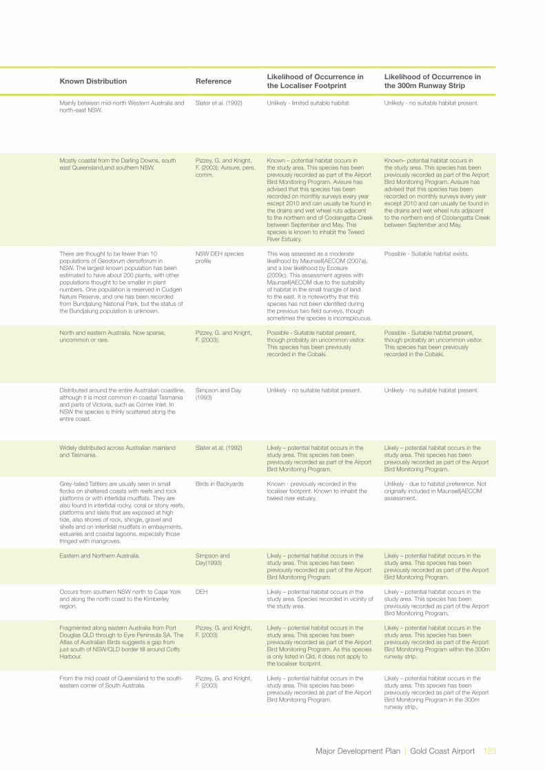
Major Development Plan | Gold Coast Airport 123
Kingdom Scientific Name Common Name Qld Status
NSW Status
Comm. status Type Preferred Habitat Known Distribution Reference Likelihood of Occurrence in
the Localiser FootprintLikelihood of Occurrence in the 300m Runway Strip
Animalia Esacus magnirostris / neglectus
Beach Stone-curlew V E Ma Bird Occurs on open, undisturbed beaches, islands, reefs, and estuarine intertidal sandflats and mudflats. Beaches with estuaries or mangroves nearby are preferred, and may also frequent river mouths, offshore sandbars and rock platforms.
Mainly between mid-north Western Australia and north-east NSW.
Slater et al. (1992) Unlikely - limited suitable habitat. Unlikely - no suitable habitat present.
Animalia Gallinago hardwickii Latham’s Snipe Ma, Mi Bird Typically soft wet ground or shallow water with a good cover of tussocks or other growth. Also occurs in open scrub and open woodlands from sea level to 200m elevation.
Mostly coastal from the Darling Downs, south east Queensland,and southern NSW.
Pizzey, G. and Knight, F. (2003); Avisure, pers. comm.
Known – potential habitat occurs in the study area. This species has been previously recorded as part of the Airport Bird Monitoring Program. Avisure has advised that this species has been recorded on monthly surveys every year except 2010 and can usually be found in the drains and wet wheel ruts adjacent to the northern end of Coolangatta Creek between September and May. This species is known to inhabit the Tweed River Estuary.
Known– potential habitat occurs in the study area. This species has been previously recorded as part of the Airport Bird Monitoring Program. Avisure has advised that this species has been recorded on monthly surveys every year except 2010 and can usually be found in the drains and wet wheel ruts adjacent to the northern end of Coolangatta Creek between September and May.
Plantae Geodorum densiflorum
Pink Nodding Orchid E Plant Geodorumdensiflorumgrows in dry sclerophyll forest often on coastal sand at lower altitudes, north from the Macleay River on the north coast of NSW.
There are thought to be fewer than 10 populations of Geodorumdensiflorum in NSW. The largest known population has been estimated to have about 200 plants, with other populations thought to be smaller in plant numbers. One population is reserved in Cudgen Nature Reserve, and one has been recorded from Bundjalung National Park, but the status of the Bundjalung population is unknown.
NSW DEH species profile
This was assessed as a moderate likelihood by Maunsell|AECOM (2007a), and a low likelihood by Ecosure (2009c). This assessment agrees with Maunsell|AECOM due to the suitability of habitat in the small triangle of land to the east. It is noteworthy that this species has not been identified during the previous two field surveys, though sometimes the species is inconspicuous.
Possible - Suitable habitat exists.
Animalia Grus rubicunda Brolga V Bird Well vegetated shallow freshwater wetlands; small isolate swamps in eucalypt forest, flood plains, grasslands; paddocks, ploughed fields, irrigated pastures, stubbles, crops; desert claypans; bore drains; sometimes tidal areas, mangroves, beaches.
North and eastern Australia. Now sparse, uncommon or rare.
Pizzey, G. and Knight, F. (2003);
Possible - Suitable habitat present, though probably an uncommon visitor. This species has been previously recorded in the Cobaki.
Possible - Suitable habitat present, though probably an uncommon visitor. This species has been previously recorded in the Cobaki.
Animalia Haematopus longirostris
Pied Oystercatcher E Bird Favours intertidal flats of inlets and bays, open beaches and sandbanks. Forages on exposed sand, mud and rock at low tide for molluscs, worms, crabs and small fish. The chisel-like bill is used to pry open or break into shells of oysters and other shellfish.
Distributed around the entire Australian coastline, although it is most common in coastal Tasmania and parts of Victoria, such as Corner Inlet. In NSW the species is thinly scattered along the entire coast.
Simpson and Day (1993)
Unlikely - no suitable habitat present. Unlikely - no suitable habitat present.
Animalia Haliaeetus leucogaster
White-bellied Sea-Eagle
Ma, Mi Bird Occurs in most habitats across Australia.
Widely distributed across Australian mainland and Tasmania.
Slater et al. (1992) Likely – potential habitat occurs in the study area. This species has been previously recorded as part of the Airport Bird Monitoring Program.
Likely – potential habitat occurs in the study area. This species has been previously recorded as part of the Airport Bird Monitoring Program.
Animalia Heteroscelus / Tringa brevipes
Grey-tailed Tattler Ma, Mi Bird Throughout coastal Australia. Grey-tailed Tattlers are usually seen in small flocks on sheltered coasts with reefs and rock platforms or with intertidal mudflats. They are also found in intertidal rocky, coral or stony reefs, platforms and islets that are exposed at high tide, also shores of rock, shingle, gravel and shells and on intertidal mudflats in embayments, estuaries and coastal lagoons, especially those fringed with mangroves.
Birds in Backyards Known - previously recorded in the localiser footprint. Known to inhabit the tweed river estuary.
Unlikely - due to habitat preference. Not originally included in Maunsell|AECOM assessment.
Animalia Hirundapus caudacutus
White-throated Needletail
Ma, Mi Bird Aerial and associated with coastal and mountain regions.
Eastern and Northern Australia. Simpson and Day(1993)
Likely – potential habitat occurs in the study area. This species has been previously recorded as part of the Airport Bird Monitoring Program.
Likely – potential habitat occurs in the study area. This species has been previously recorded as part of the Airport Bird Monitoring Program.
Animalia Ixobrychusflavicollis Black Bittern V Bird Inhabits both terrestrial and estuarine wetlands, generally in areas of permanent water and dense vegetation.
Occurs from southern NSW north to Cape York and along the north coast to the Kimberley region.
DEH Likely – potential habitat occurs in the study area. Species recorded in vicinity of the study area.
Likely – potential habitat occurs in the study area. This species has been previously recorded as part of the Airport Bird Monitoring Program.
Animalia Lewinia pectoralis Lewin’s Rail NT Bird Swamp woodlands, rushes, reeds, rank grasses in swamps, creeks, paddocks, wet heaths, samphire in salt marshes.
Fragmented along eastern Australia from Port Douglas QLD through to Eyre Peninsula SA. The Atlas of Australian Birds suggests a gap from just south of NSW/QLD border till around Coffs Harbour.
Pizzey, G. and Knight, F. (2003)
Likely – potential habitat occurs in the study area. This species has been previously recorded as part of the Airport Bird Monitoring Program. As this species is only listed in Qld, it does not apply to the localiser footprint.
Likely – potential habitat occurs in the study area. This species has been previously recorded as part of the Airport Bird Monitoring Program within the 300m runway strip.
Animalia Lichenostomus fasciogularis
Mangrove Honeyeater
V Bird Mangrove forest predominantly. This species also occurs in other near-coastal forests and woodlands, including Casuarina and paperbark swamp forests.
From the mid coast of Queensland to the south-eastern corner of South Australia.
Pizzey, G. and Knight, F. (2003)
Likely – potential habitat occurs in the study area. This species has been previously recorded as part of the Airport Bird Monitoring Program.
Likely – potential habitat occurs in the study area. This species has been previously recorded as part of the Airport Bird Monitoring Program in the 300m runway strip.
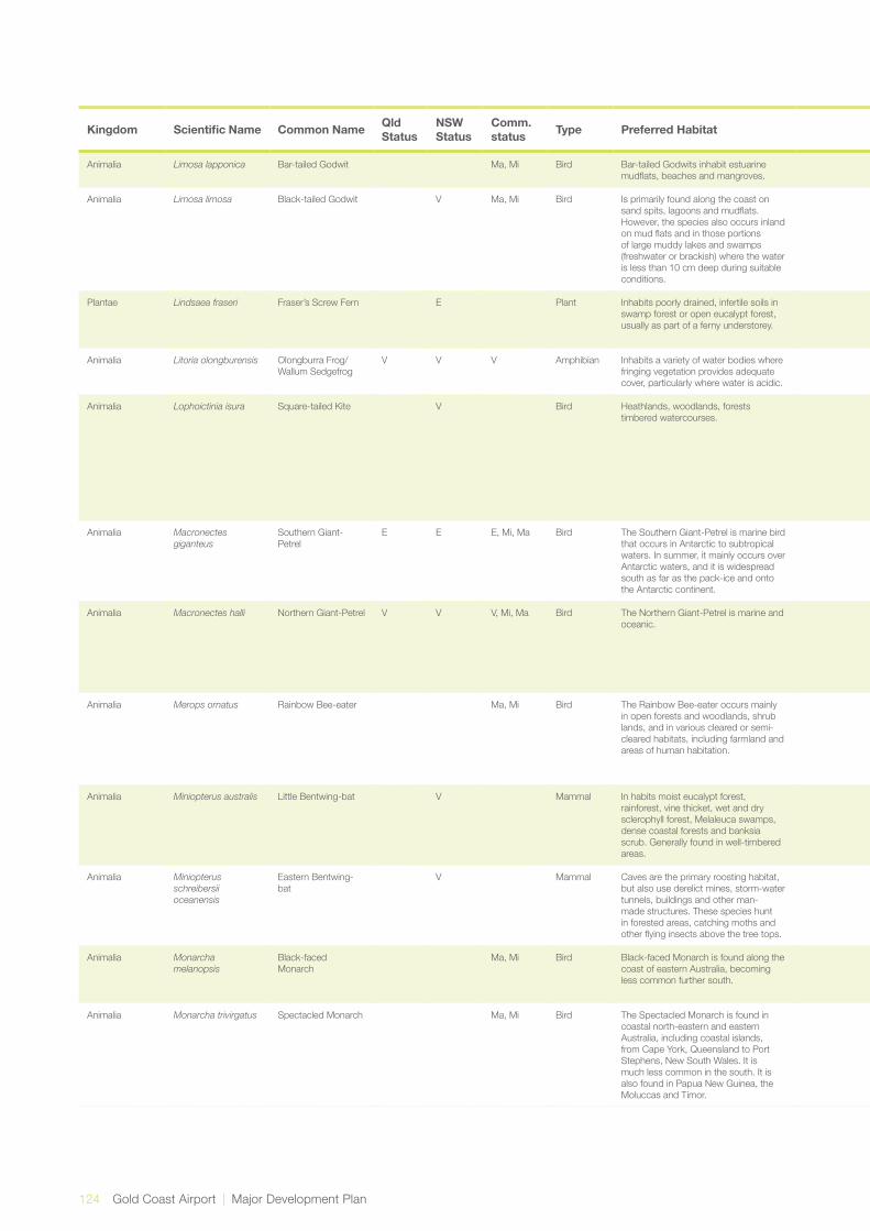
124 Gold Coast Airport | Major Development Plan
Kingdom Scientific Name Common Name Qld Status
NSW Status
Comm. status Type Preferred Habitat Known Distribution Reference Likelihood of Occurrence in
the Localiser FootprintLikelihood of Occurrence in the 300m Runway Strip
Animalia Limosa lapponica Bar-tailed Godwit Ma, Mi Bird Bar-tailed Godwits inhabit estuarine mudflats, beaches and mangroves.
They are common in coastal areas around Australia.
Birds in Backyards Known - previously observed in area. Unlikely - no suitable habitat present.
Animalia Limosa limosa Black-tailed Godwit V Ma, Mi Bird Is primarily found along the coast on sand spits, lagoons and mudflats. However, the species also occurs inland on mud flats and in those portions of large muddy lakes and swamps (freshwater or brackish) where the water is less than 10 cm deep during suitable conditions.
The Black-tailed Godwit is most common on the north coast between Weipa and Darwin. However, it is found in small numbers elsewhere, including along much of the Queensland coast south of Cairns and at scattered inland sites.
Pizzey & Knight(2003) Possible - known to enhabit the Tweed River Estuary.
Unlikely - no suitable habitat present.
Plantae Lindsaea fraseri Fraser’s Screw Fern E Plant Inhabits poorly drained, infertile soils in swamp forest or open eucalypt forest, usually as part of a ferny understorey.
In NSW it is known only from two areas; near Hastings Point on the Tweed coast and in the Pillar Valley east of Grafton. Also occurs in far north and south-east Queensland.
NSW DEH Unlikely - due to small distribution. Not included in Ecosure (2009c) or Maunsel|AECOM Assessment (2007a).
Unlikely.
Animalia Litoria olongburensis Olongburra Frog/ Wallum Sedgefrog
V V V Amphibian Inhabits a variety of water bodies where fringing vegetation provides adequate cover, particularly where water is acidic.
Coastal south east Queensland and northern New South Wales.
Barker et al.(1995) Unlikely – no suitable habitat likely to occur in the study area.
Likely - known to occur in the area.
Animalia Lophoictinia isura Square-tailed Kite V Bird Heathlands, woodlands, forests timbered watercourses.
The Square-tailed Kite ranges along coastal and subcoastal areas from south-western to northern Australia, Queensland, NSW and Victoria. In NSW, scattered records of the species throughout the state indicate that the species is a regular resident in the north, north-east and along the major west-flowing river systems. It is a summer breeding migrant to the south-east, including the NSW south coast, arriving in September and leaving by March.
NSW National Parks and Wildlife Service Threatened Species Information
Possible - Known from proximal records. Possible - Known from proximal records.
Animalia Macronectes giganteus
Southern Giant-Petrel
E E E, Mi, Ma Bird The Southern Giant-Petrel is marine bird that occurs in Antarctic to subtropical waters. In summer, it mainly occurs over Antarctic waters, and it is widespread south as far as the pack-ice and onto the Antarctic continent.
The Southern Giant-Petrel breeds on six subantarctic and Antarctic islands in Australian territory; Macquarie Island, Heard Island and McDonald Island in the Southern Ocean, and Giganteus Island, Hawker Island, and Frazier Island in the Australian Antarctic Territories.
SPRAT Unlikely - no suitable habitat present. Unlikely - no suitable habitat present.
Animalia Macronectes halli Northern Giant-Petrel V V V, Mi, Ma Bird The Northern Giant-Petrel is marine and oceanic.
The Northern Giant Petrel breeds in the sub-Antarctic, and visits areas off the Australian mainland mainly during the winter months (May-October). Immature and some adult birds are commonly seen during this period in offshore and inshore waters from around Fremantle (WA) to around Sydney (NSW).
SPRAT Unlikely - no suitable habitat present. Unlikely - no suitable habitat present.
Animalia Merops ornatus Rainbow Bee-eater Ma, Mi Bird The Rainbow Bee-eater occurs mainly in open forests and woodlands, shrub lands, and in various cleared or semi-cleared habitats, including farmland and areas of human habitation.
The Rainbow Bee-eater is distributed across much of mainland Australia.
SPRAT Likely – potential habitat occurs in the study area. This species has been previously recorded as part of the Airport Bird Monitoring Program.
Likely – potential habitat occurs in the study area. This species has been previously recorded as part of the Airport Bird Monitoring Program. Ecosure mapping shows one recording within the 300m runway strip (within Assessment Unit 8 - see Ecosure 2011a and 2011b).
Animalia Miniopterus australis Little Bentwing-bat V Mammal In habits moist eucalypt forest, rainforest, vine thicket, wet and dry sclerophyll forest, Melaleuca swamps, dense coastal forests and banksia scrub. Generally found in well-timbered areas.
East coast and ranges of Australia from Cape York in Queensland to Wollongong in NSW.
NSW DEH Possible - marginal and limited suitable habitat. This species has been previously recorded as part of the Airport Bird Monitoring Program.
Likely – potential habitat occurs in the study area. This species has been previously recorded as part of the Airport Bird Monitoring Program.
Animalia Miniopterus schreibersii oceanensis
Eastern Bentwing-bat
V Mammal Caves are the primary roosting habitat, but also use derelict mines, storm-water tunnels, buildings and other man-made structures. These species hunt in forested areas, catching moths and other flying insects above the tree tops.
Eastern Bent-wing Bats occur along the east and north-west coasts of Australia.
Churchill (1998) Possible - marginal and limited suitable habitat. This species has been previously recorded as part of the Airport Bird Monitoring Program.
Likely – potential habitat occurs in the study area. This species has been previously recorded as part of the Airport Bird Monitoring Program.
Animalia Monarcha melanopsis
Black-faced Monarch
Ma, Mi Bird Black-faced Monarch is found along the coast of eastern Australia, becoming less common further south.
The Black-faced Monarch is found in rainforests, eucalypt woodlands, coastal scrub and damp gullies. It may be found in more open woodland when migrating.
Birds in Backyards Possible - some suitable habitat present. Possible - some suitable habitat present.
Animalia Monarcha trivirgatus Spectacled Monarch Ma, Mi Bird The Spectacled Monarch is found in coastal north-eastern and eastern Australia, including coastal islands, from Cape York, Queensland to Port Stephens, New South Wales. It is much less common in the south. It is also found in Papua New Guinea, the Moluccas and Timor.
The Spectacled Monarch prefers thick understorey in rainforests, wet gullies and waterside vegetation, as well as mangroves.
Birds in Backyards Possible – potential habitat occurs in the study area. Not originally included in Maunsell|AECOM assessment (2007a).
Possible – potential habitat occurs in the study area.
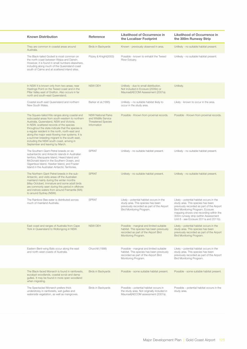
Major Development Plan | Gold Coast Airport 125
Kingdom Scientific Name Common Name Qld Status
NSW Status
Comm. status Type Preferred Habitat Known Distribution Reference Likelihood of Occurrence in
the Localiser FootprintLikelihood of Occurrence in the 300m Runway Strip
Animalia Limosa lapponica Bar-tailed Godwit Ma, Mi Bird Bar-tailed Godwits inhabit estuarine mudflats, beaches and mangroves.
They are common in coastal areas around Australia.
Birds in Backyards Known - previously observed in area. Unlikely - no suitable habitat present.
Animalia Limosa limosa Black-tailed Godwit V Ma, Mi Bird Is primarily found along the coast on sand spits, lagoons and mudflats. However, the species also occurs inland on mud flats and in those portions of large muddy lakes and swamps (freshwater or brackish) where the water is less than 10 cm deep during suitable conditions.
The Black-tailed Godwit is most common on the north coast between Weipa and Darwin. However, it is found in small numbers elsewhere, including along much of the Queensland coast south of Cairns and at scattered inland sites.
Pizzey & Knight(2003) Possible - known to enhabit the Tweed River Estuary.
Unlikely - no suitable habitat present.
Plantae Lindsaea fraseri Fraser’s Screw Fern E Plant Inhabits poorly drained, infertile soils in swamp forest or open eucalypt forest, usually as part of a ferny understorey.
In NSW it is known only from two areas; near Hastings Point on the Tweed coast and in the Pillar Valley east of Grafton. Also occurs in far north and south-east Queensland.
NSW DEH Unlikely - due to small distribution. Not included in Ecosure (2009c) or Maunsel|AECOM Assessment (2007a).
Unlikely.
Animalia Litoria olongburensis Olongburra Frog/ Wallum Sedgefrog
V V V Amphibian Inhabits a variety of water bodies where fringing vegetation provides adequate cover, particularly where water is acidic.
Coastal south east Queensland and northern New South Wales.
Barker et al.(1995) Unlikely – no suitable habitat likely to occur in the study area.
Likely - known to occur in the area.
Animalia Lophoictinia isura Square-tailed Kite V Bird Heathlands, woodlands, forests timbered watercourses.
The Square-tailed Kite ranges along coastal and subcoastal areas from south-western to northern Australia, Queensland, NSW and Victoria. In NSW, scattered records of the species throughout the state indicate that the species is a regular resident in the north, north-east and along the major west-flowing river systems. It is a summer breeding migrant to the south-east, including the NSW south coast, arriving in September and leaving by March.
NSW National Parks and Wildlife Service Threatened Species Information
Possible - Known from proximal records. Possible - Known from proximal records.
Animalia Macronectes giganteus
Southern Giant-Petrel
E E E, Mi, Ma Bird The Southern Giant-Petrel is marine bird that occurs in Antarctic to subtropical waters. In summer, it mainly occurs over Antarctic waters, and it is widespread south as far as the pack-ice and onto the Antarctic continent.
The Southern Giant-Petrel breeds on six subantarctic and Antarctic islands in Australian territory; Macquarie Island, Heard Island and McDonald Island in the Southern Ocean, and Giganteus Island, Hawker Island, and Frazier Island in the Australian Antarctic Territories.
SPRAT Unlikely - no suitable habitat present. Unlikely - no suitable habitat present.
Animalia Macronectes halli Northern Giant-Petrel V V V, Mi, Ma Bird The Northern Giant-Petrel is marine and oceanic.
The Northern Giant Petrel breeds in the sub-Antarctic, and visits areas off the Australian mainland mainly during the winter months (May-October). Immature and some adult birds are commonly seen during this period in offshore and inshore waters from around Fremantle (WA) to around Sydney (NSW).
SPRAT Unlikely - no suitable habitat present. Unlikely - no suitable habitat present.
Animalia Merops ornatus Rainbow Bee-eater Ma, Mi Bird The Rainbow Bee-eater occurs mainly in open forests and woodlands, shrub lands, and in various cleared or semi-cleared habitats, including farmland and areas of human habitation.
The Rainbow Bee-eater is distributed across much of mainland Australia.
SPRAT Likely – potential habitat occurs in the study area. This species has been previously recorded as part of the Airport Bird Monitoring Program.
Likely – potential habitat occurs in the study area. This species has been previously recorded as part of the Airport Bird Monitoring Program. Ecosure mapping shows one recording within the 300m runway strip (within Assessment Unit 8 - see Ecosure 2011a and 2011b).
Animalia Miniopterus australis Little Bentwing-bat V Mammal In habits moist eucalypt forest, rainforest, vine thicket, wet and dry sclerophyll forest, Melaleuca swamps, dense coastal forests and banksia scrub. Generally found in well-timbered areas.
East coast and ranges of Australia from Cape York in Queensland to Wollongong in NSW.
NSW DEH Possible - marginal and limited suitable habitat. This species has been previously recorded as part of the Airport Bird Monitoring Program.
Likely – potential habitat occurs in the study area. This species has been previously recorded as part of the Airport Bird Monitoring Program.
Animalia Miniopterus schreibersii oceanensis
Eastern Bentwing-bat
V Mammal Caves are the primary roosting habitat, but also use derelict mines, storm-water tunnels, buildings and other man-made structures. These species hunt in forested areas, catching moths and other flying insects above the tree tops.
Eastern Bent-wing Bats occur along the east and north-west coasts of Australia.
Churchill (1998) Possible - marginal and limited suitable habitat. This species has been previously recorded as part of the Airport Bird Monitoring Program.
Likely – potential habitat occurs in the study area. This species has been previously recorded as part of the Airport Bird Monitoring Program.
Animalia Monarcha melanopsis
Black-faced Monarch
Ma, Mi Bird Black-faced Monarch is found along the coast of eastern Australia, becoming less common further south.
The Black-faced Monarch is found in rainforests, eucalypt woodlands, coastal scrub and damp gullies. It may be found in more open woodland when migrating.
Birds in Backyards Possible - some suitable habitat present. Possible - some suitable habitat present.
Animalia Monarcha trivirgatus Spectacled Monarch Ma, Mi Bird The Spectacled Monarch is found in coastal north-eastern and eastern Australia, including coastal islands, from Cape York, Queensland to Port Stephens, New South Wales. It is much less common in the south. It is also found in Papua New Guinea, the Moluccas and Timor.
The Spectacled Monarch prefers thick understorey in rainforests, wet gullies and waterside vegetation, as well as mangroves.
Birds in Backyards Possible – potential habitat occurs in the study area. Not originally included in Maunsell|AECOM assessment (2007a).
Possible – potential habitat occurs in the study area.

126 Gold Coast Airport | Major Development Plan
Kingdom Scientific Name Common Name Qld Status
NSW Status
Comm. status Type Preferred Habitat Known Distribution Reference Likelihood of Occurrence in
the Localiser FootprintLikelihood of Occurrence in the 300m Runway Strip
Animalia Mormopterus beccarii
Tree Broom-heath V Mammal A range of vegetation types in northern Australia from rainforests to open forests and woodlands, and are often recorded along watercourses.
Widely distributed across northern Australia from Western Australia to Queensland, extending south to the north-east corner of NSW.
Churchill (1998) Possible - limited suitable habitat. This species has been previously recorded as part of the Airport Fauna Monitoring Program.
Likely – potential habitat occurs in the study area. This species has been previously recorded as part of the Airport Fauna Monitoring Program.
Animalia Mormopterus norfolkensis
Eastern Freetail-bat V Mammal Occur in dry sclerophyll forest, woodland, swamp forests and mangrove forests east of the Great Dividing Range.
The Eastern Freetail-bat is found along the east coast from south Queensland to southern NSW.
NSW National Parks and Wildlife Service Threatened Species Information
Possible - Suitable habitat exists. It has been recorded once east of the runway in 2005.
Animalia Myotis macropus / adversus
Southern Myotis / Large-footed Myotis
V Mammal Occurs close to water in caves, mine shafts, hollow-bearing trees, and storm water channels, buildings, under bridges and in dense foliage. Forages over streams and pools.
The Large-footed Myotis is found in the coastal band from the northwest of Australia, across the top end and south to western Victoria.
Churchill (1998) Possible - limited suitable habitat. This species has been previously recorded as part of the Airport Fauna Monitoring Program.
Likely – potential habitat occurs in the study area. This species has been previously recorded as part of the Airport Fauna Monitoring Program.
Animalia Numenius madagascariensis
Eastern Curlew NT Ma, Mi Bird The Eastern Curlew is widespread in coastal regions in the north-east and south of Australia, including Tasmania and scattered in other coastal areas.
Eastern Curlew is found on intertidal mudflats and sandflats, often with beds of seagrass, on sheltered coasts, especially estuaries, mangrove swamps, bays, harbours and lagoons.
Birds in Backyards Known - previously observed in area. Unlikely - no suitable habitat present.
Animalia Numenius phaeopus Whimbrel Ma, Mi Bird Whimbrels are common across northern Australia and uncommon to rare further south.
Whimbrels are found mainly on the coast, on tidal and estaurine mudflats, especially near mangroves. They are sometimes found on beaches and rocky shores.
Birds in Backyards Likely – potential habitat occurs in the study area. This species has been previously recorded as part of the Airport Fauna Monitoring Program.
Unlikely - no suitable habitat present.
Animalia Nyctophilus bifax Eastern Long-eared Bat
V Mammal Lowland subtropical rainforest and wet and swamp eucalypt forest,extending into adjacent moist eucalypt forest Coastal rainforest and patches of coastal scrub.
Found from Cape York through eastern Queensland to the far north-east corner of NSW.
Churchill (1998) Possible - limited suitable habitat. This species has been previously recorded as part of the Airport Fauna Monitoring Program.
Likely – potential habitat occurs in the study area. This species has been previously recorded as part of the Airport Fauna Monitoring Program.
Plantae Oberonia complanata
Yellow-flowered King of the Fairies
E Plant Within NSW, there are several historical collections (all pre 1917) of this species from Byron Bay and Lismore, and a collection from Coffs Harbour from 1961. More recent observations of this species have been made from Lismore and Wollumbin.
This species grows on trees and rocks in littoral rainforest, subtropical rainforest, dry rainforest, wet or dry eucalypt forests, dunes (including stabilised sands), stream-side areas, swampy forests and mangroves.
NSW DEH Unlikely - due to small distribution. Not included in Ecosure (2009c) or Maunsel|AECOM Assessment (2007a).
Unlikely.
Plantae Oldenlandia galioides / Hedyotis galiodes
E Plant In north-east NSW, known from Whiporie State Forest south of Casino and one location in the Tweed district. Also occurs on the north-west plains of NSW and in Queensland, Northern Territory and Western Australia.
Margins of seasonally inundated wetlands in paperbark swamps and Forest Red Gum (Eucalyptus tereticornis) woodlands.
NSW National Parks and Wildlife Service Threatened Species Information.
Unlikely. Unlikely.
Animalia Pandion haliatus Osprey V Ma, Mi Bird Open forests and woodlands. Coastal Queensland. Simpson and Day (1993)
Likely – potential habitat occurs in the study area. This species has been previously recorded as part of the Airport Fauna Monitoring Program.
Likely – potential habitat occurs in the study area. This species has been previously recorded as part of the Airport Fauna Monitoring Program.
Plantae Phaius australis Southern Swamp Orchid
E E Plant The Lesser Swamp-orchid is endemic to Australia and occurs in southern Queensland and northern NSW.
The Lesser Swamp-orchid is commonly associated with coastal wet heath/sedge land wetlands, swampy grassland or swampy forest and often where Broad-leaved Paperbark or Swamp Mahogany are found.
SPRAT Unlikely - due to the extent of survey that has been undertaken in the area. Included here as it is known in the area.
Unlikely - due to the extent of survey that has been undertaken in the area. Included here as it is known in the area.
Plantae Phaius tancarvilleae Lady Tankerville’s Swamp Orchid
E E Plant Swamp Lily occurs in north-east and south-east Queensland and north-east NSW.
Swamp Lily tends to occur in sunny positions in swamp forest ecotones. Associated vegetation includes swamp sclerophyll forest (Melaleuca quinquinervi-Eucalyptus robusta-Lophostemon suaveolens), swampy rainforest (often with sclerophyll emergents), or fringing open forest.
SPRAT Unlikely - due to the extent of survey in the area.
Unlikely - due to the extent of survey in the area.
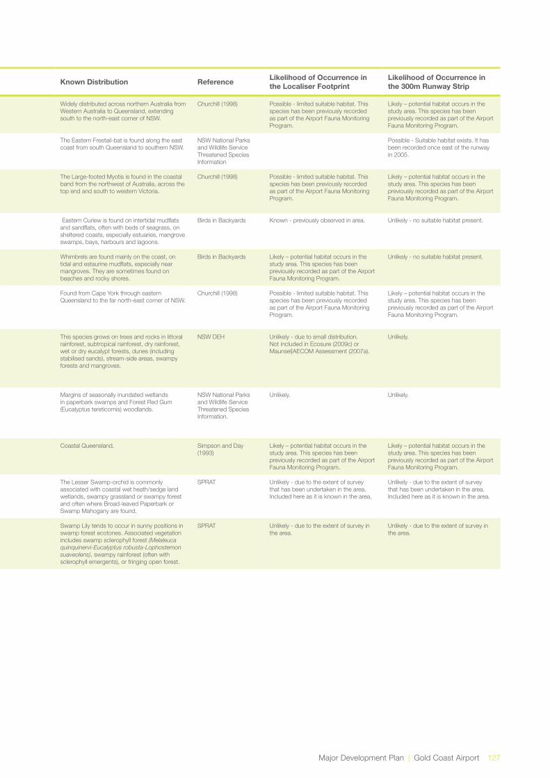
Major Development Plan | Gold Coast Airport 127
Kingdom Scientific Name Common Name Qld Status
NSW Status
Comm. status Type Preferred Habitat Known Distribution Reference Likelihood of Occurrence in
the Localiser FootprintLikelihood of Occurrence in the 300m Runway Strip
Animalia Mormopterus beccarii
Tree Broom-heath V Mammal A range of vegetation types in northern Australia from rainforests to open forests and woodlands, and are often recorded along watercourses.
Widely distributed across northern Australia from Western Australia to Queensland, extending south to the north-east corner of NSW.
Churchill (1998) Possible - limited suitable habitat. This species has been previously recorded as part of the Airport Fauna Monitoring Program.
Likely – potential habitat occurs in the study area. This species has been previously recorded as part of the Airport Fauna Monitoring Program.
Animalia Mormopterus norfolkensis
Eastern Freetail-bat V Mammal Occur in dry sclerophyll forest, woodland, swamp forests and mangrove forests east of the Great Dividing Range.
The Eastern Freetail-bat is found along the east coast from south Queensland to southern NSW.
NSW National Parks and Wildlife Service Threatened Species Information
Possible - Suitable habitat exists. It has been recorded once east of the runway in 2005.
Animalia Myotis macropus / adversus
Southern Myotis / Large-footed Myotis
V Mammal Occurs close to water in caves, mine shafts, hollow-bearing trees, and storm water channels, buildings, under bridges and in dense foliage. Forages over streams and pools.
The Large-footed Myotis is found in the coastal band from the northwest of Australia, across the top end and south to western Victoria.
Churchill (1998) Possible - limited suitable habitat. This species has been previously recorded as part of the Airport Fauna Monitoring Program.
Likely – potential habitat occurs in the study area. This species has been previously recorded as part of the Airport Fauna Monitoring Program.
Animalia Numenius madagascariensis
Eastern Curlew NT Ma, Mi Bird The Eastern Curlew is widespread in coastal regions in the north-east and south of Australia, including Tasmania and scattered in other coastal areas.
Eastern Curlew is found on intertidal mudflats and sandflats, often with beds of seagrass, on sheltered coasts, especially estuaries, mangrove swamps, bays, harbours and lagoons.
Birds in Backyards Known - previously observed in area. Unlikely - no suitable habitat present.
Animalia Numenius phaeopus Whimbrel Ma, Mi Bird Whimbrels are common across northern Australia and uncommon to rare further south.
Whimbrels are found mainly on the coast, on tidal and estaurine mudflats, especially near mangroves. They are sometimes found on beaches and rocky shores.
Birds in Backyards Likely – potential habitat occurs in the study area. This species has been previously recorded as part of the Airport Fauna Monitoring Program.
Unlikely - no suitable habitat present.
Animalia Nyctophilus bifax Eastern Long-eared Bat
V Mammal Lowland subtropical rainforest and wet and swamp eucalypt forest,extending into adjacent moist eucalypt forest Coastal rainforest and patches of coastal scrub.
Found from Cape York through eastern Queensland to the far north-east corner of NSW.
Churchill (1998) Possible - limited suitable habitat. This species has been previously recorded as part of the Airport Fauna Monitoring Program.
Likely – potential habitat occurs in the study area. This species has been previously recorded as part of the Airport Fauna Monitoring Program.
Plantae Oberonia complanata
Yellow-flowered King of the Fairies
E Plant Within NSW, there are several historical collections (all pre 1917) of this species from Byron Bay and Lismore, and a collection from Coffs Harbour from 1961. More recent observations of this species have been made from Lismore and Wollumbin.
This species grows on trees and rocks in littoral rainforest, subtropical rainforest, dry rainforest, wet or dry eucalypt forests, dunes (including stabilised sands), stream-side areas, swampy forests and mangroves.
NSW DEH Unlikely - due to small distribution. Not included in Ecosure (2009c) or Maunsel|AECOM Assessment (2007a).
Unlikely.
Plantae Oldenlandia galioides / Hedyotis galiodes
E Plant In north-east NSW, known from Whiporie State Forest south of Casino and one location in the Tweed district. Also occurs on the north-west plains of NSW and in Queensland, Northern Territory and Western Australia.
Margins of seasonally inundated wetlands in paperbark swamps and Forest Red Gum (Eucalyptus tereticornis) woodlands.
NSW National Parks and Wildlife Service Threatened Species Information.
Unlikely. Unlikely.
Animalia Pandion haliatus Osprey V Ma, Mi Bird Open forests and woodlands. Coastal Queensland. Simpson and Day (1993)
Likely – potential habitat occurs in the study area. This species has been previously recorded as part of the Airport Fauna Monitoring Program.
Likely – potential habitat occurs in the study area. This species has been previously recorded as part of the Airport Fauna Monitoring Program.
Plantae Phaius australis Southern Swamp Orchid
E E Plant The Lesser Swamp-orchid is endemic to Australia and occurs in southern Queensland and northern NSW.
The Lesser Swamp-orchid is commonly associated with coastal wet heath/sedge land wetlands, swampy grassland or swampy forest and often where Broad-leaved Paperbark or Swamp Mahogany are found.
SPRAT Unlikely - due to the extent of survey that has been undertaken in the area. Included here as it is known in the area.
Unlikely - due to the extent of survey that has been undertaken in the area. Included here as it is known in the area.
Plantae Phaius tancarvilleae Lady Tankerville’s Swamp Orchid
E E Plant Swamp Lily occurs in north-east and south-east Queensland and north-east NSW.
Swamp Lily tends to occur in sunny positions in swamp forest ecotones. Associated vegetation includes swamp sclerophyll forest (Melaleuca quinquinervi-Eucalyptus robusta-Lophostemon suaveolens), swampy rainforest (often with sclerophyll emergents), or fringing open forest.
SPRAT Unlikely - due to the extent of survey in the area.
Unlikely - due to the extent of survey in the area.

128 Gold Coast Airport | Major Development Plan
Kingdom Scientific Name Common Name Qld Status
NSW Status
Comm. status Type Preferred Habitat Known Distribution Reference Likelihood of Occurrence in
the Localiser FootprintLikelihood of Occurrence in the 300m Runway Strip
Animalia Phascolarctos cinereus
Koala V V Mammal Range of temperate, sub-tropical and tropical forest, woodland and semi-arid communities dominated by eucalypts.
Cairns to the New South Wales-Victoria border, and includes some island populations. The koala’s distribution is not continuous across this range, with some populations isolated by cleared land or unsuitable habitat.
State Forests of NSW (1995)
Unlikely - No scat or indicative markings on trees observed during various field surveys of the study area. Included in original Maunsell|AECOM assessment, and included here as the species is listed on the PMST.
Possible. Important tree species such as Eucalyptus spp. and related genera are not abundant throughout the 300m runway strip. There has been a recent recording of a koala in vegetation directly adjacent (to the west) of the 300m runway strip, though there is limited habitat values within the 300m runway strip. Prior to sighting of this koala, there has been no confirmed sightings on Koalas in east of the Tugun Bypass, with limited and dated records in the Cobaki Environment Precinct. It is likely the sighting is a one off incident. Physical barriers such as fencing and daily monitoring of the aerodrome are preventative measures that reduce potential risks from fauna impacts on aviation operations. Hence, the likelihood that koalas exist on the airport grounds is low. Refer to Bird and Wildlife Management Plan (2012b).
Animalia Planigale maculata Common Planigale V Mammal Common Planigales inhabit rainforest, eucalypt forest, heathland, marshland, grassland and rocky areas where there is surface cover, and usually close to water.
Coastal north-eastern NSW, coastal east Queensland and Arnhem Land. The species reaches its southern distribution limit on the NSW lower north coast.
State Forests of NSW (1995)
Possible – recorded throughout the vicinity of the study area, but limited suitable habitat available in the localiser footprint.
Likely– recorded in the south-west of the 300m runway strip.
Animalia Pluvialis fulva Pacific Golden Plover Ma, Mi Bird In Australia it is widespread along the coastline.
The Pacific Golden Plover is found on muddy, rocky and sandy wetlands, shores, paddocks, saltmarsh, coastal golf courses, estuaries and lagoons.
Birds in Backyards Likely – potential habitat occurs in the study area. This species has been previously recorded as part of the Airport Fauna Monitoring Program. This species is known to inhabit the Tweed River Estuary.
Unlikely - no suitable habitat present.
Animalia Potorous tridactylus Long-nosed Potoroo V V Mammal The Long-nosed Potoroo (SE Mainland) is sparsely distributed along the coast and Great Dividing Range of south-east Queensland through NSW.
It can be found in wet eucalypt forests to coastal heaths and scrubs.
SPRAT Unlikely - due to distribution. Not included in original Maunsell|AECOM assessment.
Unlikely - occurs to the north-west, near Stewart Road, Tugun. And to the north-west of the Cobaki Environment Precinct. Previous surveys undertaken as part of the Significant Fauna Monitoring Program have not detected this species despite extensive trapping effort over many years.
Animalia Pteropus poliocephalus
Grey-headed Flying-fox
V V Mammal Variety of habitats including rainforest, mangroves, paperbark swamps, wet and dry sclerophyll forests and cultivated areas.
East coast of Australia from Rockhampton (Qld) to western Victoria.
Churchill (1998) Unlikely - the localiser footprint contains very little suitable habitat for this species. Despite this, the species is known to fly over airport land regularly and there is continued standardised monitoring of the flying-fox hazard via nightly monitoring by safety offices during peak flying-fox periods.
Possible – though limited foraging or roosting habitat available on site and recorded throughout the locality. Despite this, the species is known to fly over airport land regularly and there is continued standardised monitoring of the flying-fox hazard via nightly monitoring by safety offices during peak flying-fox periods. It is worth noting that there are only small patches of suitable habitat for Pteropus poliocephalus. This is the area of Melaleuca and Swamp She-oak forests in the north west of the 300m runway strip.
Plantae Pterostylis nigricans Dark Greenhood V Plant The Dark Greenhood occurs in north-east NSW north from Evans Head, and in Queensland.
Coastal heathland with Heath Banksia (Banksia ericifolia), and lower-growing heath with lichen-encrusted and relatively undisturbed soil surfaces, on sandy soils
NSW DEH Unlikely - no suitable habitat present. Not mentioned in previous reports.
Possible. Potentially suitable habitat exists.
Animalia Ptilinopus regina Rose-crowned Fruit-Dove
V Bird Occur mainly in subtropical and dry rainforest and occasionally in moist eucalypt forest and swamp forest, where fruit is plentiful.
Coast and ranges of eastern NSW and Queensland, from Newcastle to Cape York.
Simpson and Day(1993)
Unlikely – limited suitable habitat likely to occur in the study area.
Unlikely – limited suitable habitat likely to occur in the study area.
Animalia Ptilinopus superbus Superb Fruit-Dove V Ma Bird The Superb Fruit-Dove is found along the coast and nearby ranges of Queensland and New South Wales south to Moruya.
The Superb Fruit-Dove is found in rainforests, rainforest margins, mangroves, wooded stream-margins, and even isolated figs, lilly pillies and pittosporums.
NSW DEH Unlikely – marginal and limited habitat occurs in the study area.
Unlikely – marginal habitat occurs in the study area.
Animalia Recurvirostra novaehollandiae
Red-necked Avocet Ma Bird Red-necked Avocet is found throughout mainland Australia.
The Red-necked Avocet is found in large shallow freshwater or saltwater wetlands and estuarine mudflats.
Birds in Backyards Possible. Suitable habitat exists. Unlikely - no suitable habitat present.
Animalia Rhipidurarufifrons Rufous Fantail Ma, Mi Bird The Rufous Fantail is found in northern and eastern coastal Australia, being more common in the north.
The Rufous Fantail is found in rainforest, dense wet forests, swamp woodlands and mangroves, preferring deep shade, and is often seen close to the ground.
Birds in Backyards Possible – some potential habitat occurs in the study area. Not originally included in Maunsell|AECOM assessment (2007a).
Possible – some potential habitat occurs in the study area.

Major Development Plan | Gold Coast Airport 129
Kingdom Scientific Name Common Name Qld Status
NSW Status
Comm. status Type Preferred Habitat Known Distribution Reference Likelihood of Occurrence in
the Localiser FootprintLikelihood of Occurrence in the 300m Runway Strip
Animalia Phascolarctos cinereus
Koala V V Mammal Range of temperate, sub-tropical and tropical forest, woodland and semi-arid communities dominated by eucalypts.
Cairns to the New South Wales-Victoria border, and includes some island populations. The koala’s distribution is not continuous across this range, with some populations isolated by cleared land or unsuitable habitat.
State Forests of NSW (1995)
Unlikely - No scat or indicative markings on trees observed during various field surveys of the study area. Included in original Maunsell|AECOM assessment, and included here as the species is listed on the PMST.
Possible. Important tree species such as Eucalyptus spp. and related genera are not abundant throughout the 300m runway strip. There has been a recent recording of a koala in vegetation directly adjacent (to the west) of the 300m runway strip, though there is limited habitat values within the 300m runway strip. Prior to sighting of this koala, there has been no confirmed sightings on Koalas in east of the Tugun Bypass, with limited and dated records in the Cobaki Environment Precinct. It is likely the sighting is a one off incident. Physical barriers such as fencing and daily monitoring of the aerodrome are preventative measures that reduce potential risks from fauna impacts on aviation operations. Hence, the likelihood that koalas exist on the airport grounds is low. Refer to Bird and Wildlife Management Plan (2012b).
Animalia Planigale maculata Common Planigale V Mammal Common Planigales inhabit rainforest, eucalypt forest, heathland, marshland, grassland and rocky areas where there is surface cover, and usually close to water.
Coastal north-eastern NSW, coastal east Queensland and Arnhem Land. The species reaches its southern distribution limit on the NSW lower north coast.
State Forests of NSW (1995)
Possible – recorded throughout the vicinity of the study area, but limited suitable habitat available in the localiser footprint.
Likely– recorded in the south-west of the 300m runway strip.
Animalia Pluvialis fulva Pacific Golden Plover Ma, Mi Bird In Australia it is widespread along the coastline.
The Pacific Golden Plover is found on muddy, rocky and sandy wetlands, shores, paddocks, saltmarsh, coastal golf courses, estuaries and lagoons.
Birds in Backyards Likely – potential habitat occurs in the study area. This species has been previously recorded as part of the Airport Fauna Monitoring Program. This species is known to inhabit the Tweed River Estuary.
Unlikely - no suitable habitat present.
Animalia Potorous tridactylus Long-nosed Potoroo V V Mammal The Long-nosed Potoroo (SE Mainland) is sparsely distributed along the coast and Great Dividing Range of south-east Queensland through NSW.
It can be found in wet eucalypt forests to coastal heaths and scrubs.
SPRAT Unlikely - due to distribution. Not included in original Maunsell|AECOM assessment.
Unlikely - occurs to the north-west, near Stewart Road, Tugun. And to the north-west of the Cobaki Environment Precinct. Previous surveys undertaken as part of the Significant Fauna Monitoring Program have not detected this species despite extensive trapping effort over many years.
Animalia Pteropus poliocephalus
Grey-headed Flying-fox
V V Mammal Variety of habitats including rainforest, mangroves, paperbark swamps, wet and dry sclerophyll forests and cultivated areas.
East coast of Australia from Rockhampton (Qld) to western Victoria.
Churchill (1998) Unlikely - the localiser footprint contains very little suitable habitat for this species. Despite this, the species is known to fly over airport land regularly and there is continued standardised monitoring of the flying-fox hazard via nightly monitoring by safety offices during peak flying-fox periods.
Possible – though limited foraging or roosting habitat available on site and recorded throughout the locality. Despite this, the species is known to fly over airport land regularly and there is continued standardised monitoring of the flying-fox hazard via nightly monitoring by safety offices during peak flying-fox periods. It is worth noting that there are only small patches of suitable habitat for Pteropus poliocephalus. This is the area of Melaleuca and Swamp She-oak forests in the north west of the 300m runway strip.
Plantae Pterostylis nigricans Dark Greenhood V Plant The Dark Greenhood occurs in north-east NSW north from Evans Head, and in Queensland.
Coastal heathland with Heath Banksia (Banksia ericifolia), and lower-growing heath with lichen-encrusted and relatively undisturbed soil surfaces, on sandy soils
NSW DEH Unlikely - no suitable habitat present. Not mentioned in previous reports.
Possible. Potentially suitable habitat exists.
Animalia Ptilinopus regina Rose-crowned Fruit-Dove
V Bird Occur mainly in subtropical and dry rainforest and occasionally in moist eucalypt forest and swamp forest, where fruit is plentiful.
Coast and ranges of eastern NSW and Queensland, from Newcastle to Cape York.
Simpson and Day(1993)
Unlikely – limited suitable habitat likely to occur in the study area.
Unlikely – limited suitable habitat likely to occur in the study area.
Animalia Ptilinopus superbus Superb Fruit-Dove V Ma Bird The Superb Fruit-Dove is found along the coast and nearby ranges of Queensland and New South Wales south to Moruya.
The Superb Fruit-Dove is found in rainforests, rainforest margins, mangroves, wooded stream-margins, and even isolated figs, lilly pillies and pittosporums.
NSW DEH Unlikely – marginal and limited habitat occurs in the study area.
Unlikely – marginal habitat occurs in the study area.
Animalia Recurvirostra novaehollandiae
Red-necked Avocet Ma Bird Red-necked Avocet is found throughout mainland Australia.
The Red-necked Avocet is found in large shallow freshwater or saltwater wetlands and estuarine mudflats.
Birds in Backyards Possible. Suitable habitat exists. Unlikely - no suitable habitat present.
Animalia Rhipidurarufifrons Rufous Fantail Ma, Mi Bird The Rufous Fantail is found in northern and eastern coastal Australia, being more common in the north.
The Rufous Fantail is found in rainforest, dense wet forests, swamp woodlands and mangroves, preferring deep shade, and is often seen close to the ground.
Birds in Backyards Possible – some potential habitat occurs in the study area. Not originally included in Maunsell|AECOM assessment (2007a).
Possible – some potential habitat occurs in the study area.

130 Gold Coast Airport | Major Development Plan
Kingdom Scientific Name Common Name Qld Status
NSW Status
Comm. status Type Preferred Habitat Known Distribution Reference Likelihood of Occurrence in
the Localiser FootprintLikelihood of Occurrence in the 300m Runway Strip
Animalia Rostratula australis Australian Painted Snipe
V E V Bird It is most common in eastern Australia, where it has been recorded at scattered locations throughout much of Queensland, NSW, Victoria and south-eastern South Australia.
The Australian Painted Snipe generally inhabits shallow terrestrial freshwater (occasionally brackish) wetlands, including temporary and permanent lakes, swamps and claypans. They also use inundated or waterlogged grassland or saltmarsh, dams, rice crops, sewage farms and bore drains.
Avisure,pers. comm. Unlikely - Based on the survey data dating back 13 years and personal observations by Martin Ziviani (a consultant with Avisure, who undertake monthly bird surveys at the airport) over the past 7 years there have not been any records of Painted Snipe on Gold Coast Airport. Furthermore, after his discussions with Avisure’s ornithological team at Avisure, it seems unlikely that GCA contains suitable permanent habitat for this species as they are non-migratory and attracted to shalUnlikely, grassy wetlands.
Unlikely - Based on the survey data dating back 13 years and personal observations by Martin Ziviani (a consultant with Avisure, who undertake monthly bird surveys at the airport) over the past 7 years there have not been any recent records of Painted Snipe on Gold Coast Airport. Furthermore, after his discussions with Avisure’s ornithological team at Avisure, it seems unlikely that GCA contains suitable permanent habitat for this species as they are non-migratory and attracted to shalUnlikely, grassy wetlands.
Animalia Saccolaimus flaviventris
Yellow-bellied Sheathtail-bat
V Mammal Variety of environments, including forests.
The Yellow-bellied Sheathtail-bat is a wide-ranging species found across northern and eastern Australia.
NSW DEH Possible, though limited foraging or roosting habitat available on site.
Possible - some suitable habitat present.
Animalia Syconycteris australis
Common Blossom-bat
V Mammal Common Blossom-bats often roost in littoral rainforest and feed on nectar and pollen from flowers in adjacent heathland and paperbark swamps. They have also been recorded in a range of other vegetation communities, such as subtropical rainforest, wet sclerophyll forest and other coastal forests.
Coastal areas of eastern Australia from Hawks Nest in NSW to Cape York peninsula in Queensland.
NSW DEH Possible, though limited foraging or roosting habitat available on site.
Likely - potential habitat occurs in the study area. This species has been previously recorded on the airport site.
Animalia Thalassarche cauta cauta
Shy Albatross, Tasmanian Shy Albatross
V, Mi, Ma Bird The Shy Albatross is a marine species occurring in subantarctic and subtropical waters.
The recent separation of Shy Albatrosses from other closely related taxa confounds our understanding of its at-sea distribution. Shy Albatrosses appear to occur over all Australian coastal waters below 25° S. It is most commonly observed over the shelf waters around Tasmania and southeastern Australia (Barton 1979; Blakers et al.1984; Tickell 1995; Reid et al. in press). It appears to be less pelagic than many other albatrosses, ranging well inshore over the continental shelf, even entering bays and harbours (del Hoyo et al. 1992; Reid et al. in press). Most adult Shy Albatrosses remain in the waters off southeast Australia all year round, and seldom venture more than 600km from the breeding colony.
SPRAT Unlikely - no suitable habitat present. Unlikely - no suitable habitat present.
Animalia Thalassarche cauta salvini
Salvin’s Albatross V, Mi, Ma Bird Salvin’s Albatross is a marine species occurring in subantarctic and subtropical waters. Salvin’s Albatross nest’s on level or gently sloping ledges, summits, slopes and caves of rocky islets and stacks, usually in broken terrain with little soil and vegetation.
Salvin’s Albatross is a non-breeding visitor to Australian waters.
SPRAT Unlikely - no suitable habitat present. Unlikely - no suitable habitat present.
Animalia Thalassarche cauta steadi
White-capped Albatross
V V, Mi, Ma Bird The White-capped Albatross is a marine species and occurs in subantarctic and subtropical waters.
The White-capped Albatross is probably common off the coast of south-east Australia throughout the year.
SPRAT Unlikely - no suitable habitat present. Unlikely - no suitable habitat present.
Animalia Thalassarche eremita Chatham Albatross E, Mi, Ma Bird The Chatham Albatross is a marine species. It occurs in subantarctic and subtropical waters.
Breeding for the Chatham Albatross is restricted to Pyramid Rock, Chatham Islands, off the coast of New Zealand. The principal foraging range for this species is in coastal waters off eastern and southern New Zealand, and Tasmania.
SPRAT Unlikely - no suitable habitat present. Unlikely - no suitable habitat present.
Animalia Thalassarche melanophris
Black-browed Albatross
V V, Mi, Ma Bird The Black-browed Albatross is a marine species that inhabits Antarctic, subantarctic and temperate waters and occasionally enters the tropics
Individuals are mostly confined to subantarctic and Antarctic waters.
SPRAT Unlikely - no suitable habitat present. Unlikely - no suitable habitat present.

Major Development Plan | Gold Coast Airport 131
Kingdom Scientific Name Common Name Qld Status
NSW Status
Comm. status Type Preferred Habitat Known Distribution Reference Likelihood of Occurrence in
the Localiser FootprintLikelihood of Occurrence in the 300m Runway Strip
Animalia Rostratula australis Australian Painted Snipe
V E V Bird It is most common in eastern Australia, where it has been recorded at scattered locations throughout much of Queensland, NSW, Victoria and south-eastern South Australia.
The Australian Painted Snipe generally inhabits shallow terrestrial freshwater (occasionally brackish) wetlands, including temporary and permanent lakes, swamps and claypans. They also use inundated or waterlogged grassland or saltmarsh, dams, rice crops, sewage farms and bore drains.
Avisure,pers. comm. Unlikely - Based on the survey data dating back 13 years and personal observations by Martin Ziviani (a consultant with Avisure, who undertake monthly bird surveys at the airport) over the past 7 years there have not been any records of Painted Snipe on Gold Coast Airport. Furthermore, after his discussions with Avisure’s ornithological team at Avisure, it seems unlikely that GCA contains suitable permanent habitat for this species as they are non-migratory and attracted to shalUnlikely, grassy wetlands.
Unlikely - Based on the survey data dating back 13 years and personal observations by Martin Ziviani (a consultant with Avisure, who undertake monthly bird surveys at the airport) over the past 7 years there have not been any recent records of Painted Snipe on Gold Coast Airport. Furthermore, after his discussions with Avisure’s ornithological team at Avisure, it seems unlikely that GCA contains suitable permanent habitat for this species as they are non-migratory and attracted to shalUnlikely, grassy wetlands.
Animalia Saccolaimus flaviventris
Yellow-bellied Sheathtail-bat
V Mammal Variety of environments, including forests.
The Yellow-bellied Sheathtail-bat is a wide-ranging species found across northern and eastern Australia.
NSW DEH Possible, though limited foraging or roosting habitat available on site.
Possible - some suitable habitat present.
Animalia Syconycteris australis
Common Blossom-bat
V Mammal Common Blossom-bats often roost in littoral rainforest and feed on nectar and pollen from flowers in adjacent heathland and paperbark swamps. They have also been recorded in a range of other vegetation communities, such as subtropical rainforest, wet sclerophyll forest and other coastal forests.
Coastal areas of eastern Australia from Hawks Nest in NSW to Cape York peninsula in Queensland.
NSW DEH Possible, though limited foraging or roosting habitat available on site.
Likely - potential habitat occurs in the study area. This species has been previously recorded on the airport site.
Animalia Thalassarche cauta cauta
Shy Albatross, Tasmanian Shy Albatross
V, Mi, Ma Bird The Shy Albatross is a marine species occurring in subantarctic and subtropical waters.
The recent separation of Shy Albatrosses from other closely related taxa confounds our understanding of its at-sea distribution. Shy Albatrosses appear to occur over all Australian coastal waters below 25° S. It is most commonly observed over the shelf waters around Tasmania and southeastern Australia (Barton 1979; Blakers et al.1984; Tickell 1995; Reid et al. in press). It appears to be less pelagic than many other albatrosses, ranging well inshore over the continental shelf, even entering bays and harbours (del Hoyo et al. 1992; Reid et al. in press). Most adult Shy Albatrosses remain in the waters off southeast Australia all year round, and seldom venture more than 600km from the breeding colony.
SPRAT Unlikely - no suitable habitat present. Unlikely - no suitable habitat present.
Animalia Thalassarche cauta salvini
Salvin’s Albatross V, Mi, Ma Bird Salvin’s Albatross is a marine species occurring in subantarctic and subtropical waters. Salvin’s Albatross nest’s on level or gently sloping ledges, summits, slopes and caves of rocky islets and stacks, usually in broken terrain with little soil and vegetation.
Salvin’s Albatross is a non-breeding visitor to Australian waters.
SPRAT Unlikely - no suitable habitat present. Unlikely - no suitable habitat present.
Animalia Thalassarche cauta steadi
White-capped Albatross
V V, Mi, Ma Bird The White-capped Albatross is a marine species and occurs in subantarctic and subtropical waters.
The White-capped Albatross is probably common off the coast of south-east Australia throughout the year.
SPRAT Unlikely - no suitable habitat present. Unlikely - no suitable habitat present.
Animalia Thalassarche eremita Chatham Albatross E, Mi, Ma Bird The Chatham Albatross is a marine species. It occurs in subantarctic and subtropical waters.
Breeding for the Chatham Albatross is restricted to Pyramid Rock, Chatham Islands, off the coast of New Zealand. The principal foraging range for this species is in coastal waters off eastern and southern New Zealand, and Tasmania.
SPRAT Unlikely - no suitable habitat present. Unlikely - no suitable habitat present.
Animalia Thalassarche melanophris
Black-browed Albatross
V V, Mi, Ma Bird The Black-browed Albatross is a marine species that inhabits Antarctic, subantarctic and temperate waters and occasionally enters the tropics
Individuals are mostly confined to subantarctic and Antarctic waters.
SPRAT Unlikely - no suitable habitat present. Unlikely - no suitable habitat present.
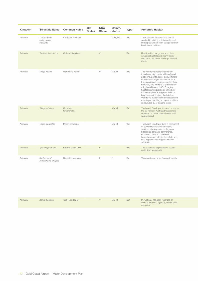
132 Gold Coast Airport | Major Development Plan
Kingdom Scientific Name Common Name Qld Status
NSW Status
Comm. status Type Preferred Habitat Known Distribution Reference Likelihood of Occurrence in
the Localiser FootprintLikelihood of Occurrence in the 300m Runway Strip
Animalia Thalassarche melanophris impavida
Campbell Albatross V, Mi, Ma Bird The Campbell Albatross is a marine sea bird inhabiting sub-Antarctic and subtropical waters from pelagic to shelf-break water habitats.
The Campbell Albatross is a non-breeding visitor to Australian waters. Non-breeding birds are most commonly seen foraging over the oceanic continental slopes off Tasmania, Victoria and New South Wales.
SPRAT Unlikely - no suitable habitat present. Unlikely - no suitable habitat present.
Animalia Todiramphus chloris Collared Kingfisher V Bird Restricted to mangroves and other estuarine habitats and mainly occur about the mouths of the larger coastal rivers.
Around the northern Australian coastline from Shark Bay in Western Australia to the mouth of the Clarence River, NSW.
DEH Known – potential habitat occurs in the study area. This species has been previously recorded as part of the Airport Fauna Monitoring Program. Species observed in SEPP 14 area.
Likely – potential habitat occurs in the study area. This species has been previously recorded as part of the Airport Fauna Monitoring Program. Species observed in SEPP 14 area within the 300m runway strip.
Animalia Tringa incana Wandering Tattler P Ma, Mi Bird The Wandering Tattler is generally found on rocky coasts with reefs and platforms, points, spits, piers, offshore islands and shingle beaches or beds. It is occasionally seen on coral reefs or beaches, and tends to avoid mudflats (Higgins & Davies 1996). Foraging habitat is among rocks or shingle, or in shallow pools at edges of reefs or beaches, mainly along the tide line. Wandering Tattlers have been recorded roosting or perching on top of boulders surrounded by or close to water.
Coastal areas SPRAT Unlikely - no suitable habitat present. This species is known to inhabit the Tweed River Estuary however.
Unlikely - no suitable habitat present.
Animalia Tringa nebularia Common Greenshank
Ma, Mi Bird The Marsh Sandpiper is common across the far north of Australia though more scattered on other coastal areas and sparse inland.
Marsh Sandpipers are commonly seen singly, or in small to large flocks in fresh or brackish (slightly salty) wetlands such as rivers, water meadows, sewage farms, drains, lagoons and swamps.
Birds in Backyards Known - previously observed in the localiser footprint. Not originally included in Maunsell|AECOM assessment (2007a).
Unlikely - no suitable habitat present.
Animalia Tringa stagnatilis Marsh Sandpiper Ma, Mi Bird The Marsh Sandpiper lives in permanent or ephemeral wetlands of varying salinity, including swamps, lagoons, billabongs, saltpans, saltmarshes, estuaries, pools on inundated floodplains, and intertidal mudflats and also regularly at sewage farms and saltworks.
Coastal areas. SPRAT Possible - known to inhabit the Tweed River Estuary.
Unlikely - no suitable habitat present.
Animalia Tyto longimembris Eastern Grass Owl V Bird This species is a specialist of coastal and inland grasslands.
Occurs along the east coast from Cape York to the Manning River in NSW. It also occurs in western Queensland.
Simpson and Day (1993)
Possible – potential habitat occurs in the study area. Species historically recorded in the vicinity of the site.
Unlikely - no suitable habitat present.
Animalia Xanthomyza/Anthochaera phrygia
Regent Honeyeater E E Bird Woodlands and open Eucalypt forests. Occurs within 300 km of coastline from Brisbane to Adelaide. In NSW, most records are from the Great Dividing Range, mainly on the North-West Plains, North-West and South-West Slopes, Northern Tablelands, Central Tablelands and Southern Tablelands regions; and also the Central Coast and Hunter Valley regions. NSW, the Regent Honeyeater has an area of occupancy of less than 200 km2 (NSW SC 2010) and is now largely absent from many areas where it was formerly recorded. This is most notably the Riverina and South-West Slopes, but also in many areas of the Central-West and North-West Slopes, and on the Central Coast around Sydney.
DEH, SPRAT Unlikely - this species was not included in the Ecosure Assessment (2009c) but was included in the Maunsell|AECOM assessment (2007a). This assessment disagrees with the Maunsell|AECOM (2007a) , which classified it as moderate.
Unlikely - due to habitat preference.
Animalia Xenus cinereus Terek Sandpiper V Ma, Mi Bird In Australia, has been recorded on coastal mudflats, lagoons, creeks and estuaries.
Widely distributed across mainland Australia and Tasmania.
Simpson and Day (1993)
Unlikely - due to habitat preference. Unlikely - due to habitat preference.
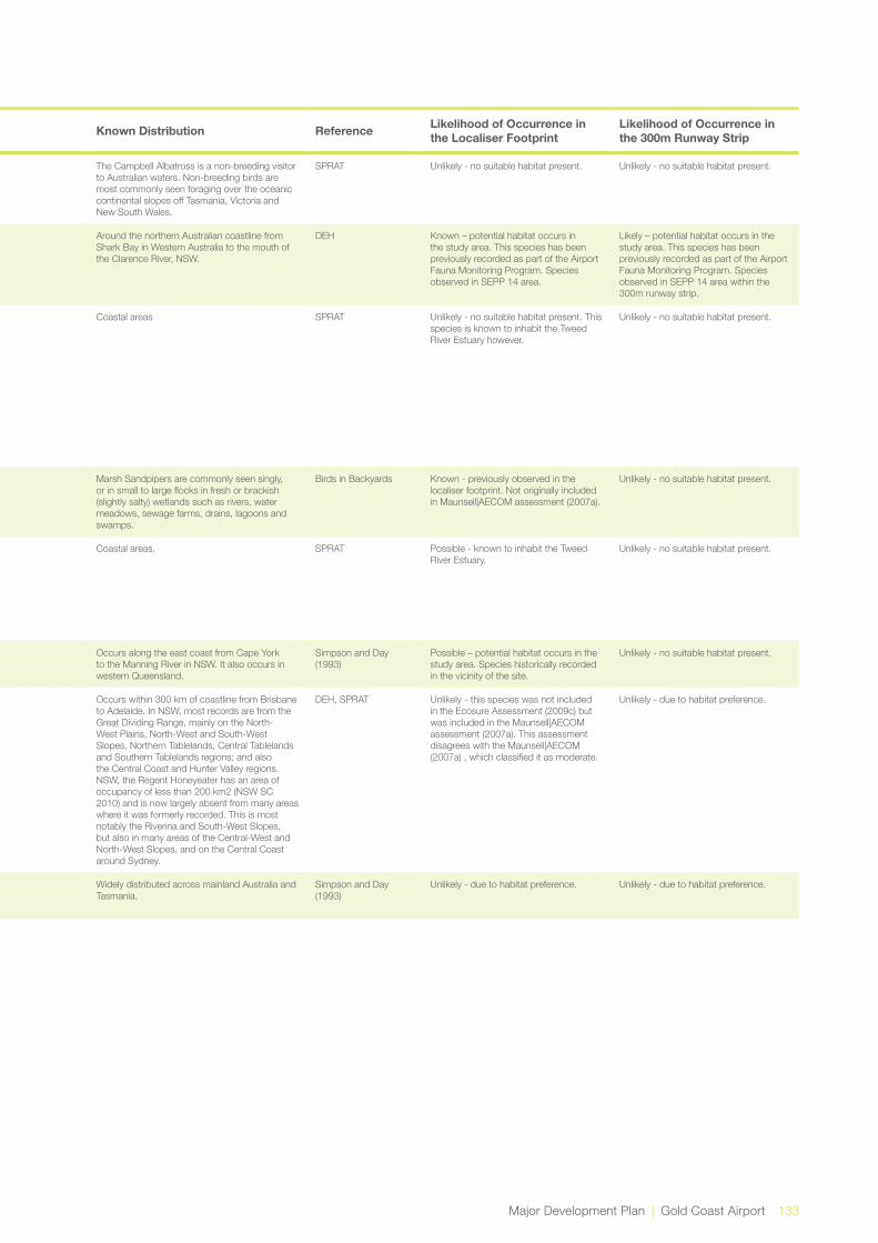
Major Development Plan | Gold Coast Airport 133
Kingdom Scientific Name Common Name Qld Status
NSW Status
Comm. status Type Preferred Habitat Known Distribution Reference Likelihood of Occurrence in
the Localiser FootprintLikelihood of Occurrence in the 300m Runway Strip
Animalia Thalassarche melanophris impavida
Campbell Albatross V, Mi, Ma Bird The Campbell Albatross is a marine sea bird inhabiting sub-Antarctic and subtropical waters from pelagic to shelf-break water habitats.
The Campbell Albatross is a non-breeding visitor to Australian waters. Non-breeding birds are most commonly seen foraging over the oceanic continental slopes off Tasmania, Victoria and New South Wales.
SPRAT Unlikely - no suitable habitat present. Unlikely - no suitable habitat present.
Animalia Todiramphus chloris Collared Kingfisher V Bird Restricted to mangroves and other estuarine habitats and mainly occur about the mouths of the larger coastal rivers.
Around the northern Australian coastline from Shark Bay in Western Australia to the mouth of the Clarence River, NSW.
DEH Known – potential habitat occurs in the study area. This species has been previously recorded as part of the Airport Fauna Monitoring Program. Species observed in SEPP 14 area.
Likely – potential habitat occurs in the study area. This species has been previously recorded as part of the Airport Fauna Monitoring Program. Species observed in SEPP 14 area within the 300m runway strip.
Animalia Tringa incana Wandering Tattler P Ma, Mi Bird The Wandering Tattler is generally found on rocky coasts with reefs and platforms, points, spits, piers, offshore islands and shingle beaches or beds. It is occasionally seen on coral reefs or beaches, and tends to avoid mudflats (Higgins & Davies 1996). Foraging habitat is among rocks or shingle, or in shallow pools at edges of reefs or beaches, mainly along the tide line. Wandering Tattlers have been recorded roosting or perching on top of boulders surrounded by or close to water.
Coastal areas SPRAT Unlikely - no suitable habitat present. This species is known to inhabit the Tweed River Estuary however.
Unlikely - no suitable habitat present.
Animalia Tringa nebularia Common Greenshank
Ma, Mi Bird The Marsh Sandpiper is common across the far north of Australia though more scattered on other coastal areas and sparse inland.
Marsh Sandpipers are commonly seen singly, or in small to large flocks in fresh or brackish (slightly salty) wetlands such as rivers, water meadows, sewage farms, drains, lagoons and swamps.
Birds in Backyards Known - previously observed in the localiser footprint. Not originally included in Maunsell|AECOM assessment (2007a).
Unlikely - no suitable habitat present.
Animalia Tringa stagnatilis Marsh Sandpiper Ma, Mi Bird The Marsh Sandpiper lives in permanent or ephemeral wetlands of varying salinity, including swamps, lagoons, billabongs, saltpans, saltmarshes, estuaries, pools on inundated floodplains, and intertidal mudflats and also regularly at sewage farms and saltworks.
Coastal areas. SPRAT Possible - known to inhabit the Tweed River Estuary.
Unlikely - no suitable habitat present.
Animalia Tyto longimembris Eastern Grass Owl V Bird This species is a specialist of coastal and inland grasslands.
Occurs along the east coast from Cape York to the Manning River in NSW. It also occurs in western Queensland.
Simpson and Day (1993)
Possible – potential habitat occurs in the study area. Species historically recorded in the vicinity of the site.
Unlikely - no suitable habitat present.
Animalia Xanthomyza/Anthochaera phrygia
Regent Honeyeater E E Bird Woodlands and open Eucalypt forests. Occurs within 300 km of coastline from Brisbane to Adelaide. In NSW, most records are from the Great Dividing Range, mainly on the North-West Plains, North-West and South-West Slopes, Northern Tablelands, Central Tablelands and Southern Tablelands regions; and also the Central Coast and Hunter Valley regions. NSW, the Regent Honeyeater has an area of occupancy of less than 200 km2 (NSW SC 2010) and is now largely absent from many areas where it was formerly recorded. This is most notably the Riverina and South-West Slopes, but also in many areas of the Central-West and North-West Slopes, and on the Central Coast around Sydney.
DEH, SPRAT Unlikely - this species was not included in the Ecosure Assessment (2009c) but was included in the Maunsell|AECOM assessment (2007a). This assessment disagrees with the Maunsell|AECOM (2007a) , which classified it as moderate.
Unlikely - due to habitat preference.
Animalia Xenus cinereus Terek Sandpiper V Ma, Mi Bird In Australia, has been recorded on coastal mudflats, lagoons, creeks and estuaries.
Widely distributed across mainland Australia and Tasmania.
Simpson and Day (1993)
Unlikely - due to habitat preference. Unlikely - due to habitat preference.

Appendix BReferences
9.0

136 Gold Coast Airport | Major Development Plan
References
ANZECC/ARMCANZ (2000). Australian and New Zealand Guidelines for Fresh and Marine Water Quality. Australian and New Zealand Environment and Conservation Council and Agriculture and Resource Management Council of Australia and New Zealand.
Australian Wetlands (2010). Coastal Management Plan for Cobaki Broadwater and Terranora Broadwater, Prepared for the Tweed Shire Council. Publicly available.
Bamford, M., Watkins, D., Bancroft, W., Tischler, G., and J. Wahl (2008). Migratory Shorebirds of the East Asian – Australian Flyway: Populations Estimates and Internally Important Sites, Wetlands International – Oceania, Canberra. Publicly available.
Burn, R. F., (1998). “Mollusca: the southern synthesis”, Fauna of Australia, Vol. 5, Part B (eds Beesley, P.L., Ross, G. J. B. and Wells, A.), CSIRO Publishing: Melbourne, pp.961-974. Publicly available
Cobb, G.C., (2007). (Aug 9) Elysia bangtawaensis in nthn New South Wales. [Message in] Sea Slug Forum. Australian Museum, Sydney. Available from http://www.seaslugforum.net/find/20377. Publicly available.
Daly T, (2013). Coastal saltmarsh, Primefact. NSW Department of Primary Industries. Viewed: 15th November 2013, available at www.dpi.nsw.gov.au. Publicly available.
DECCW, Department of Environment, Climate Change and Water NSW (2010). Shorebirds of Northern New South Wales, based on a report prepared by D. Rohweder and funded by the Northern Rivers Catchment Management Authority, Department of Environment, Climate Change and Water NSW, Sydney. Publicly available.
DEWHA, Department of Environment, Water, Heritage and the Arts (2009). SignificantImpactGuidelinesfor36migratory shorebird species, EPBC Act Policy Statement 3.21, Commonwealth of Australia, Canberra. http://www.environment.gov.au/resource/draft-significant-impact-guidelines-36-migratory-shorebird-species-migratory-species-epbc. Publicly available.
DOE, Department of Environment, (2013). Actions on, or impacting upon, Commonwealth land, and actions by Commonwealth agencies, Commonwealth of Australia, Canberra. Publicly available.
DOE, Department of Environment (2013). Matters of NationalEnvironmentalSignificance-Significantimpactguidelines 1.1. Canberra: Commonwealth of Australia. Publicly available.
Ecosure (2013). Gold Coast Airport Fauna Monitoring Program Review, prepared for Gold Coast Airport Proprietary Limited, Coolangatta.
Everick Heritage Consultants Pty Ltd (2015). Due Diligence Cultural Heritage Assessment, Gold Coast Airport Instrument Landing System, QLD/NSW. A report prepared for Gold Coast Airport Pty Ltd.
GCAPL, Gold Coast Airport Limited (2011). Airport Master Plan, CGAPL, Coolangatta. http://goldcoastairport.com.au/regulatory/airport-master-plan/. Publicly available.
Hall, J., (1990). An Assessment of Aboriginal sites at the Coolangatta Airport, prepared for Gold Coast Airport Proprietary Limited, Coolangatta.
Hansen, B. (2001). A Brief Overview of Literature on Waders in Decline, Stilt, No. 60, pp. 6-8. Publicly available.
Keith DA (2004). Ocean shores to desert dunes: The native vegetation of New South Wales and the ACT. Department of Environment and Conservation (NSW), Sydney. Publicly available.
Lindenmayer, D. and H Nix (1993). “Ecological Principles for the Design of Wildlife Corridors”, Conservation Biology, Vol. 7, No. 3, pp. 627-630. Publicly available.
OEH, Office of Environment and Heritage, NSW (2011a). Coastal Saltmarsh in the NSW North Coast, Sydney Basin and South East Corner bioregions – endangered ecological community listing. Viewed 16 May 2013, available online at http://www.environment.nsw.gov.au/determinations/CoastalSaltmarshEndSpListing.htm. Publicly available.
OEH, Office of Environment and Heritage, NSW (2011b), SubtropicalcoastalfloodplainforestoftheNSW North Coast bioregion - endangered ecological community listing. Viewed 16 May 2013, available online at: http://www.environment.nsw.gov.au/determinations/SubtropicalCoastalFloodplainEndSpListing.htm. Publicly available.
9.0 Appendix B
Major Development Plan | Gold Coast Airport 137
OEH, Office of Environment and Heritage, NSW (2011c). SwampoakfloodplainforestoftheNSWNorthCoast,Sydney Basin and South East Corner bioregions - endangered ecological community listing. Viewed 16 May 2013, available online at: http://www.environment.nsw.gov.au/determinations/SwampOakFloodplainEndSpListing.htm. Publicly available.
OEH, Office of Environment and Heritage, NSW (2011d). SwampsclerophyllforestoncoastalfloodplainsoftheNSW North Coast, Sydney Basin and South East Corner bioregions - endangered ecological listing. Viewed 16 May 2013, available online at: http://www.environment.nsw.gov.au/determinations/SwampSchlerophyllEndSpListing.htm. Publicly available.
Parsons Brickerhoff (2004). Tugun Bypass Environment Impact Statement: Technical Paper Number 12 Flora and Fauna Assessment, prepared as part of the Tugun Bypass Alliance, Queensland Department of Main Roads, Nerang. http://www.tmr.qld.gov.au/Projects/Name/T/Tugun-Bypass-project/Tugun-Bypass-Environmental-Impact-Statement.aspx. Publicly available.
Rohweder, D.A. (2001). Assessment of the Impact of the Proposed Tugun Bypass - Option C4: Kenny Drive to Boyd Street: Terrestrial and Estuarine Birds, Report Prepared for the Qld Department of Main Roads. Publicly available.
Rohweder, D.A. (2007). ‘Changes in the summer population of shorebirds in the Tweed River Estuary, northern New South Wales between 1987 and 2003’, Australian Zoologist, Vol. 34 (2), pp. 125-137. Publicly available.
Tozer MG, Turner K, Keith DA, Tindall D, Pennay C, Simpson C, MacKenzie B, Beukers P and Cox S (2010). “Native vegetation of southeast NSW: a revised classification and map for the coast and eastern tablelands”. Cunninghamia, 11: 359–406. Viewed: 15/5/2013. Publicly available.
TSSC, Threatened Species Scientific Committee (2013). Conservation Advice for Subtropical and Temperate Coastal Saltmarsh, viewed online 15th November 2013, available at http://www.environment.gov.au/cgi-bin/sprat/public/publicshowcommunity.pl?id=118. Publicly available.
Watkins, D (1993). “A National Plan for Shorebird Conservation”, in Australia Australian Wader Studies Group of the Royal Australasian Ornithologists Union, Moonee Ponds, Victoria. Publicly available.
West R.J., Thorogood C.A., Walford T.R. and Williams R.J. (1985). An estuarine inventory for New South Wales, Australia. Fisheries Bulletin 2. Department of Agriculture, New South Wales. Publicly available.