James-Paul Dice, Meteorologist WHNT-TV, Huntsville Dr. Walt Petersen, Scientist, University of...
27
James-Paul Dice, Meteorologist WHNT-TV, Huntsville Dr. Walt Petersen, Scientist, University of Alabama Huntsville
-
Upload
colin-baldwin-james -
Category
Documents
-
view
220 -
download
0
Transcript of James-Paul Dice, Meteorologist WHNT-TV, Huntsville Dr. Walt Petersen, Scientist, University of...

James-Paul Dice, Meteorologist WHNT-TV, Huntsville
Dr. Walt Petersen, Scientist, University of Alabama Huntsville

ARMOR: Advanced Radar for Meteorological and Operational Research.
• Location : Huntsville Intl. Airport• Transmit frequency: 5625 MHz• Peak Power: 350 kW• Antenna Diameter 3.7 m (12 ft CF
Parabolic)• Antenna Beam width: 1.0o
• Maximum rotation rate: 6 rpm• Transmit polarization: Simultaneous H and V,
or H• Receive polarization: SIGMET dual-channel;
H and V• Signal Process: SIGMET RVP/8• Variables: Z, V, W, ZDR, DP, KDP, hv, LDR
Partners: UAH, NASA, NSSTC, WHNT-TV
Deployed in Huntsville by the NWS in 1977 as a local warning radar (WSR-74C) then refurbished and upgraded to Doppler in 1991.
Radar donated to UAH in 2002 and upgraded to dual-polarimetry using the SIGMET Antenna Mounted Receiver 11/04. Renamed: ARMOR.

9/23/04 WSR-74C disassembly 10/29-11/05 ARMOR Reassembly

Digital dual-receiver
Simultaneous transmit and receive via 4-port switch and magic-T
Waveguide Assembly
Receiver

The Science Behind ARMOR

ConventionalRadar (NEXRAD)
PolarimetricRadar (ARMOR)
POLARIMETRIC RADAR?

Polarimetric Variables1. Reflectivity factor Z at horizontal polarization
- Measure of size and concentration of scatters
(dominated by SIZE)
2. Differential reflectivity ZDR
- Measure of median drop diameter→ SIZE/SHAPE
- Useful for rain / hail / snow discrimination→ SIZE/SHAPE/PHASE
3. Differential phase ΦDP (Specific Differential Phase- KDP)
- Efficient for accurate rainfall estimation→ NUMBER/SHAPE
- Immune to radar miscalibration, attenuation, and partial beam blockage
4. Cross-correlation coefficient ρhv
- Indicator of mixed precipitation → SHAPE/PHASE
- Efficient for identifying nonmeteorological scatterers
Research:
NCAR, CSU, NASA, UND, DLR, BMRC, NOAA-ETL
ARMOR
Operational:
NEXRAD, TV
vs
Small ZDR Large ZDR

• More accurate rainfall estimation (10-20% max accumulation error as opposed to 200-300%).
• Why? Because we collect information on drop size/shape/concentration and are able to mitigate hail contamination.
• Identification of precipitation types and discrimination between
meteorological and non-meteorological scatterers
• Improvement in radar data quality: Self consistent way to calibrate using polarimetric variables
Advantages of a Dual-Polarization RadarReally just a self-consistent way of obtaining a more complete description of the particle types and shapes present in a given volume of space.
vs
Small ZDR Large ZDRSmall drops Large drops
vs
Hail Rain
vs
Insects Rain
Mitigates the multiple Z-R issues!

How Does Dual Polarimetric Radar Help Hydrology?RAINFALL: A CLASSIC EXAMPLE
The Fort Collins Flash Flood: A Robust Integrated Application of Dual-Polarization Radar
CSU-CHILL: 2145 L2108: RHI: dBZ, ZDR, KDP
Review Petersen et al., BAMS, 1999

• Spherical shape and tumbling of hail results in low ZDR’s (a ZDR “hole”).
• Large drop recirculation on edge of echo vault at x=25 km, z=2-3 km.
• Drop column clearly extends into sub-freezing portion of cloud- the hail process
ZDR in Range-Height mode …………..(ARMOR has this scanning capability and this mode provides an early look into the development of intense storms)
ZH
ZH
ZDR
ZDR
0 15 30 45 60
0 15 30 45 60
-1 0 1 2 3 4 5
-1 0 1 2 3 4 5
ZH
ZH
ZDR
ZDR
ZH
ZH
ZDR
ZDR
0 15 30 45 60
0 15 30 45 60
-1 0 1 2 3 4 5
-1 0 1 2 3 4 5
“ZDR Column” in developing convection
“ZDR Hole” in Hail
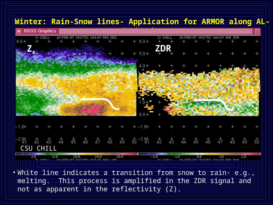
Winter: Rain-Snow lines- Application for ARMOR along AL-TN border
ZDRZe
CSU CHILL
• White line indicates a transition from snow to rain- e.g., melting. This process is amplified in the ZDR signal and not as apparent in the reflectivity (Z).

61+ dBZ in cells: Hail or Rain?ARMOR: 1541 UTC 12/09/04
ZDR
>3.5 dB ZDR: Big rain drops or melting hail
Note Lightning in LISDAD

ARMOR Dual-Polarimetric facility provides a unique opportunity for end-to-end transfer of research technology to public safety
• Flooding (Radar “state of the art” rainfall estimates and flexible scanning)
• Emergency Management
• Surveillance, threat detection, warning
• Mitigation
• Case study and climatological area- accurate rainfall boundary conditions (0.125 x 0.5 km) for modeled watershed response (improved flood plain planning)
• Severe Thunderstorms
• Additional local source for improving detection, monitoring of severe weather (tornadic, strong winds, hail, lightning)
• Winter Precipitation
• Rain-snow boundary (HSV Airport Authority very interested in this product); planning decision support
• Homeland Security
• Boundary layer winds for plume dispersion modeling- feasibility?

On-the-Air with ARMOR

ARMOR Operates Like No Other TV Radar
• The radar alternates between a traditional Doppler mode and a multi-elevation polarimetric scan. This flexibility means more data into our office.
• Traditional radar measurements (reflectivity and Traditional radar measurements (reflectivity and velocity) are available at all times.velocity) are available at all times.
• Radar alternates its operation between a live .05Radar alternates its operation between a live .05oo surveillance scan and a 3 elevation volumetric scan at surveillance scan and a 3 elevation volumetric scan at .07.07oo,1.3,1.3oo, and 2.0, and 2.0oo
• Following each volume scan, a hydrometeor Following each volume scan, a hydrometeor identification algorithm produces a product.identification algorithm produces a product.

Hydrometeor ID Algorithm OutputHydrometeor ID Algorithm Output

Hydrometeor ID Algorithm OutputHydrometeor ID Algorithm Output
Large HailLarge Hail
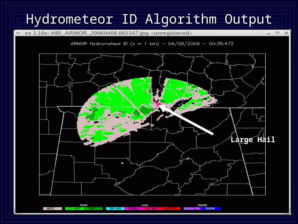
Hydrometeor ID Algorithm OutputHydrometeor ID Algorithm Output
Large HailLarge Hail

December 10, 2004 Hail Event
61 dBZ with VIL ~30 kg/m2

ARMOR and KHTX Side-by-Side Comparison December 10, 2004

KHTX NEXRAD View of Storm
Note: Pink Baron Services Severe SCIT. Neither NEXRAD or Baron Hail algorithm detected presence of hail during this event.

-1.8 -0.9 0.1 1.0 1.9 2.9 3.6 -15 - 5 5 15 25 35 45
dBZ ZDR
ARMOR: 12/10/04 17:55:06 EL=1.3o
Rain
55+ dBZ
Hail
55+ dBZ
Rain
2 to 3.5 dB
Hail
-1 to 0.5 dB
Hail
-1.5 to 0.5 dB
Rain/Hail
-0.5 to 2 dB Rain/Hail
40-55 dBZ
Hail
50-55 dBZ
At 17:55 In-cloud (IC) flash rate ~ 3/minute in southern cell
No IC’s in northern cell at 17:55
No Cloud-to-Ground (CG) lightning in either cell for 20 minutes centered on 17:55
Only 3 CG’s detected for duration of stormsLMA S. Cell 17:52:30 – 17:57:30
LMA Total Lightning Data
(southern cell mass)

Ground-truth Report of Dime-Size Hail
Owens Crossroads, Alabama.

ARMOR Control and DisplayARMOR Control and Display

ARMOR Control and DisplayARMOR Control and Display
Sigmet IRIS WorkstationFasTrac VIPIR

This is the Next Generation of Doppler
• Improved Flash Flood Forecasting
• Hydrometeor Identification
• Possible Tornado Debris Detection to Improve Warnings
• The Bottom Line: More data is a competitive advantage