JAMAICA SEISMOGRAPH NETWORK IRIS Metadata Workshop Managing Waveform Data and Related Metadata for...
46
JAMAICA SEISMOGRAPH NETWORK IRIS Metadata Workshop Managing Waveform Data and Related Metadata for Seismic Networks Foz do Iguacu, Brazil August 13 -19, 2010 Presenter: Paul Williams Earthquake Unit Jamaica
-
Upload
maude-todd -
Category
Documents
-
view
227 -
download
2
Transcript of JAMAICA SEISMOGRAPH NETWORK IRIS Metadata Workshop Managing Waveform Data and Related Metadata for...

JAMAICA SEISMOGRAPH NETWORK
IRIS Metadata Workshop
Managing Waveform Data and Related Metadata for Seismic Networks
Foz do Iguacu, BrazilAugust 13 -19, 2010
Presenter: Paul WilliamsEarthquake Unit
Jamaica

FACTS ABOUT JAMAICA• Location = 18 N, 76-78 W ~400Km E of Grand Cayman and
150km S of SE Cuba.• Spanish Colony: 1494 -1655• British Colony : 1655-1962• Got independence from Britain in 1962• Area = 11424 km sq.• Length of island east to west 243 km Width of maximum
distance N- S 80 km• Mountainous with highest mountain of 2000m in the east.• Population of 2.8 million.• Experience moderate to high seismicity.

LOCATION OF JAMAICA

HISTORY OF EARTHQUAKES IN JAMAICA
HISTORY OF EARTHQUAKES IN JAMAICA
Eastern Jamaica• 1692 (X)• 1771 (VII)• 1907 (IX)• 1914 (VII)• 1993 (VII)
Western Jamaica• 1839 (VII)• 1943 (VII)• 1957 (VIII)

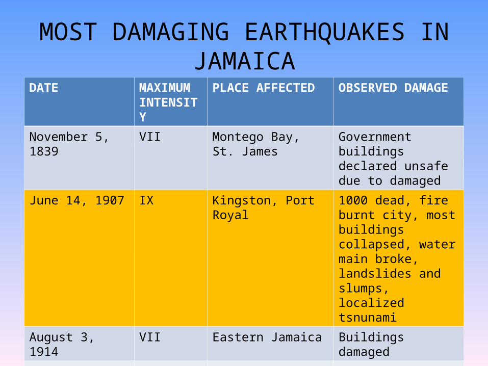
MOST DAMAGING EARTHQUAKES IN JAMAICA
DATE MAXIMUM INTENSITY
PLACE AFFECTED OBSERVED DAMAGE
1667 VIII Landslide
March 1,1668 VII Port Royal Houses and Ships damage
June 7, 1692 X Port Royal, Kingston, Vere Plains, Also felt island-wide
2000 dead; buildings collapsed, liquefaction, subsidence, landslide and water ejected
September 3, 1771 VII Port Royal, Kingston Damaged to structures , felt on boats in port.
November 11, 1812 VIII Kingston Several peopled killed; wall fell, buildings damaged
April 10, 1824 VII Kingston, Clarendon, St. Catherine
Some houses fell, loud noise accompanied shock
DATE MAXIMUMINTENSITY
PLACE AFFECTED OBSERVED DAMAGE
November 5, 1839 VII Montego Bay, St. James
Government buildings declared unsafe due to damaged
June 14, 1907 IX Kingston, Port Royal 1000 dead, fire burnt city, most buildings collapsed, water main broke, landslides and slumps, localized tsnunami
August 3, 1914 VII Eastern Jamaica Buildings damaged
July 15,1943 VII St. Elizabeth
March 1, 1957 VIII Montego Bay, St. James and felt island-wide
4 dead, landslide and bridge damage, utility poles and lines damage
January 13, 1993 VII Kingston, felt island-wide
2 dead, few case of damage to buildings
MOST DAMAGING EARTHQUAKES IN JAMAICA

PAW-IRIS_July 2010
1692 (June 7) Port Royal M? 1907 (Jan 14) Kingston Ms 6.5


MOST ACTIVE BLOCK MARCH 2009 – APRIL 2010
JSN Local sub-region blocks Blue Mountain being the most active block
-78.5š
-78.5š
-78š
-78š
-77.5š
-77.5š
-77š
-77š
-76.5š
-76.5š
-76š
-76š
18š 18š
18.5š 18.5š
BBJ
BNJ
CMJGWJ
HOJ
NEJ
MBJ
MCJ
PCJ
STH
YHJ
CVJNegril
Montego Bay
Ocho Rios
Port Antonio
Mandeville
Kingston
Black River
12 3 4
5
67
89
1011
12
13
1415
16
17 18 19 20 21 2223
24 25 26Fault
JSN Station
Accelerograph

History of Earthquake monitoring and the JSN in Jamaica
The first modern seismograph in Jamaica was installed in the early 1960s at the Geological Survey Division.
In 1963 the station was moved to the Mona campus of the University of the West Indies from where the growth of the Jamaica Seismograph Network began.
In April 1990 digital recording and data processing were introduced at the Central Recording Station (CRS) using the Soufriere software of Beckles and Shepherd (1984). The system required two PC-Ats, 12-bit 16-channel digitizer and a GOES satellite clock.

• In 1997 the Earthquake Unit started using a software called PC-Seismic Data Acquisition (PC-SDA)(developed by Avirac and Shapira) and PC-Seismic Data Processing (PC-SDP) (Malisky and Shapira). PC-SDA uses a 16 bit digitizer with Trimble GPS for timing.
• In 2006 the EQU started using seislog and seisan with a 16 bit SARA digitizer.
• We should start using Earthworm before the end of 2010.
History of Earthquake monitoring and the JSN in Jamaica

June 20, 2010 PW/EQU/UWI-Mona 13
MISSION STATEMENTThrough operating the Jamaica Seismograph Network and affiliating with other Caribbean and Regional Networks
the Earthquake Unit seeks to understand earthquake processes in and around Jamaica and advise the society about earthquake hazard
thereby encouraging community awareness and the application of mitigative strategies to development.

STAFF AT THE EARTHQUAKE UNIT
6 full-time staff:• Research Fellow/Geophysicists • Network Engineer/Manager• Seismic Analyst• Information/Electronics Technologist• Scientific Officer – Education & Information• Administrative SecretaryPlusOne Postgraduate student and two part-time staff

The Earthquake Unit
• The Unit operates the Jamaica Seismograph Network, Jamaica Strong Motion Network and the GPS Monitoring Network.
• Archives and records all earthquake related data for Jamaica.
• Conducts relative research on Jamaica seismicity and tectonics.
• Performs national and site specific seismic hazard assessment for national and private entities.

Earthquake Unit contd.
Informs the public about felt earthquake• Operates the National Data Centre (NDC)
for Jamaica in keeping with the CTBTO• Hosts tours by schools and other
community groups at the Central Recording Station

JSN (Z)(8)JSN (3C)(4)
JSMN (8)GPS (36)
SEISMIC MONITORING IN JAMAICA 1997-2010
Morant/Middle CayPedro/NE Cay

JAMAICA SEISMOGRAPH NETWORK
• The Jamaica Seismic Network consists of 12 analog short period stations.
• There are four 3-component and 8 single vertical component station
• The JSN is a telemetry network using UHF and VHF radios.
• The station are mostly powered by solar power.

REPEATER
REMOTE STATION
UHFREMOTE STATIO
N
CENTRAL RECORDING STATION
UHF LINK
VHF
JAMAICA TELEMETRY SEISMIC NETWORK
RADIO LINKS
RANGE FROM
15KM TO 60KM

June 20, 2010 PAW/EQU/UWI-Mona 20
THE JAMAICA SEISMOGRAPH NETWORK TELEMETRY LINK

Telemetry Link
• The stations are located across the island and data from these stations is transmitted to the CRS using UHF and VHF radios.
• The central recording station (CRS) is located at the University of the West Indies, Mona Campus in Kingston (HOJ on the Map).
• Short links are used for radio links because of:– the terrain the links are repeated several times
before reaching the CRS.– Using smaller RF power to minimize the power
requirement so that solar power can be used.

L4CSEISMOMETER
Antenna
UHFTRANSMITTER
AMPLIFIER FILTER & VCO
ANTENNA
RECEIVER DISCRIMINATOR16 BIT SARA
DIGITIZER
16 BIT NATIONAL INSTRUMENTS &
MULTIPLEXER
SEISLOG &
SEISAN
WINDOWSPC(SDA) &
PC(SDP)
ANALOG DRUM
RECORDER
GPS
Jamaica Telemetry Seismic Network

ID Code Station Name LattitudeLongitude
ElevationSite Condition
BBJ Bamboo, St. Ann 18.3865N77.2623W
766m, isolated pier on limestone bedrock
BNJ Bonny Gate, St. Mary
18.3210N76.9505W
485m, concrete slab on limestone bedrock
CMJ Castle Mountain, Portland
18.1351N76.3613W
391m, concrete slab on limestone bedrock
GWJ Greenwich, St. Andrew
18.0740N
76.7280W
1170m,concrete slab on weathered soil
HOJ Hope (Mona), St. Andrew
18.0050N76.7490W
228m, Quaternary alluvium of unknown depth
Jamaica Seismograph Network Stations

MBJ Montego Bay, St. James 18.4050N77.8630W
513m, Concrete slab on limestone bedrock
MCJ Munroe College, St. Elizabeth
17.9253N77.8630W
661m, Isolated pier on limestone bedrock
PCJ Portland Cottage, Clarendon
17.9253N77.1570W
198m, isolated pier on limestone bedrock
RHJ(COJ)
Red Hills, St. Andrew(Cooper’s Hill)
18.7410N76.8540W
779m, no sensor
STH Stony Hill, St. Andrew 18.0770N76.8097N
504m, isolated pier on limestonebedrock
CVJ Pike (Coleyville) , Manchester
18.226N
77.535
969 m, concrete slab on limestone bedrock
YHJ Yallahs Hill, St. Thomas 17.8920N76.4930W
600m, isolated pier on limestone bedrock

Station Owner of Site
Sensor Site Condition
Stony Hill (STH)
UWI 3 component L4-CEtna accelerograph(Broadband Garulp
CMG-3ESPD and SAM)
Pier
Greenwich (GWJ)
Private Owner
Single component L4-C Vault to be constructed
Yallahs (YHJ) Government Single component Pier
Castle Mountain (CMJ)
Government Mark Product L4-C Pier to be constructed
Bonny Gate (BNJ)
Govermnent Mark Product L4-C(Garulp 3ESPD and
SAM)
Vault
Bamboo (BBJ) Government Mark Product L4-C single component
Pier
Current State of Network
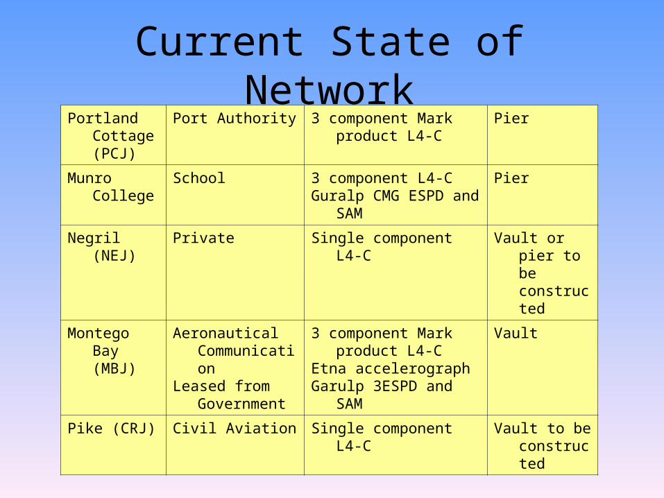
Portland Cottage (PCJ)
Port Authority 3 component Mark product L4-C
Pier
Munro College School 3 component L4-CGuralp CMG ESPD and
SAM
Pier
Negril (NEJ) Private Single component L4-C Vault or pier to be constructed
Montego Bay (MBJ)
Aeronautical Communication
Leased from Government
3 component Mark product L4-C
Etna accelerographGarulp 3ESPD and SAM
Vault
Pike (CRJ) Civil Aviation Single component L4-C Vault to be constructed
Current State of Network

Seismometers in use at the JSN
Mark Product L-4C Guralp CMG 40T Guralp CMG-6TD

Earthquake recorded near the center of the Island

REMOTE SEISMIC STATION AT NEGRIL (NEJ) and YALLAHS (YHJ)

Three Component Station at Munro College (MCJ)
Earthquake Unit, UWI

Seismic Station at Greenwich (GWJ)
Remote seismic station Station powered by solar

CENTRAL RECORDING STATION
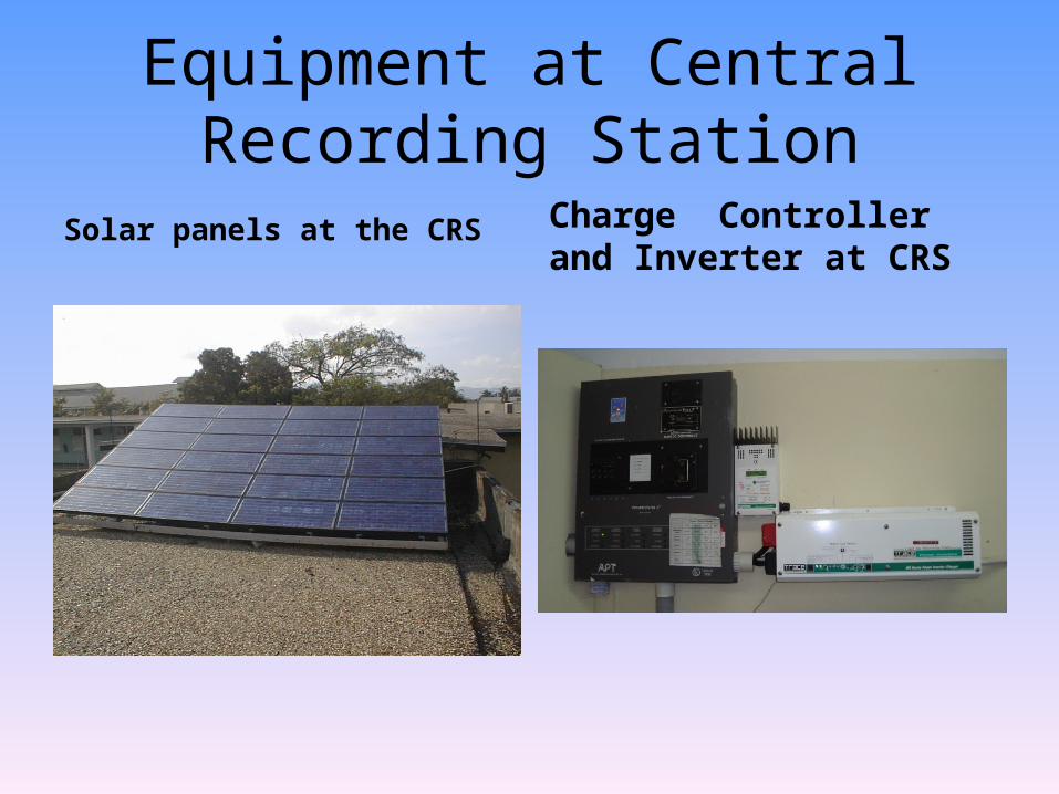
Equipment at Central Recording Station
Solar panels at the CRS Charge Controller and Inverter at CRS

SOFTWARE USED FOR DATA ACQUISITION AND ANALYSIS
For data acquisition• Seislog • PC-Seismic Data Acquisition (PC-SDA)
For processing or data analysis• Seisan• PC-Seismic Data Processing (PC-SDP)

GPS MONITORING

June 15, 2004 The Earthquake Unit, UWI - Mona, Kingston 7, Jamaica 36
GPS Monuments across Jamaica

GPS MONITORING IN JAMAICAGPS Monitoring on Morant Cays offshore GPS installed in Geodetic Monument

GPS Monitoring Station
Portable GPS Station Fixed GPS Station

USGS-GSN Station Mount Denham Jamaica (MTDJ)
Equipment at station Conducting test at station

USGS-GSN MTDJ STATION
Comprehensive (Nuclear) Test Ban Treaty Organisation
(CTBTO)
Jamaica’s National Data Centre (NDC)
Earthquake Unit, UWI

CTBTO National Data Center
VSAT for Jamaica NDC NDC Equipment

Accelerograph StationETNA installed on a pier in a free field installation
K2 installed

SUMMARY
• The Jamaica Seismograph consist of 12 short period seismograph station – four 3-component station and eight single-component station.
• The Jamaica Strong Motion Network consist of 8 accelerograph (6 Etnas, 1 CMG 5TD and one K2). There are three other etnas owned by the other institutions that are operated by the Earthquake Unit. And 2 REFTEK accelerograph will be installed at the NMIA airport
•

SUMMARY CONTINUE
• GPS network has 36 monitoring points three of which have a fixed GPS installation
• To improve our network we hope to upgrade our network to digital.
• Install 6 broadband seismometers• Have automatic solution of earthquakes.• Have real time access to accelerograph to
produce shake map.

PAW-IRIS_July 2010
THE END