IV.D GEOLOGIC HAZARDS - planning.lacity.org Geology.pdf · The APEFZ requires that geologic studies...
29
City of Los Angeles IV.D-1 Wilshire Boulevard Temple Master Plan Project Draft EIR ENV-2010-1407-EIR January 2011 IV.D GEOLOGIC HAZARDS 1. INTRODUCTION This section identifies and evaluates geologic and soils conditions at the Wilshire Boulevard Temple Master Plan Project site that could affect, or be affected by, implementation of the proposed Project. This section incorporates and summarizes information contained in the Comprehensive Geotechnical Engineering Exploration Update #2 investigation prepared by Byer Geotechnical, Inc, dated June 18, 2010, which is provided in Appendix IV.D. 2. REGULATORY FRAMEWORK a. Federal Regulations i. Flood Insurance Rate Maps Flood Insurance Rate Maps are prepared by the Federal Insurance Administration of the Department of Housing and Urban Development (HUD) after a risk study for a community has been completed and the risk premium rates have been established. The maps indicate the risk premium zones applicable in the community and when those rates are effective. They are used in making flood plain determinations and to determine if a proposed action is located in the base or critical action flood plain, as appropriate. ii. General Permit for Discharges of Storm Water Associated with Construction Activity Because the proposed Project is over 1 acre in size, a General Permit for Discharges of Storm Water Associated with Construction Activity is required by the Los Angeles Regional Water Quality Control Board (LARWQCB), as part of the National Pollution Discharge Elimination System (NPDES), to control erosion and pollution during construction. The permit requires the project applicant to prepare and submit a Storm Water Pollution Prevention Plan (SWPPP) to be administered throughout Project construction. The SWPPP must list Best Management Practices (BMPs) that the discharger (Project applicant) will be used to protect storm water runoff.
Transcript of IV.D GEOLOGIC HAZARDS - planning.lacity.org Geology.pdf · The APEFZ requires that geologic studies...

City of Los Angeles IV.D-1 Wilshire Boulevard Temple Master Plan Project Draft EIR
ENV-2010-1407-EIR January 2011
IV.D GEOLOGIC HAZARDS
1. INTRODUCTION
This section identifies and evaluates geologic and soils conditions at the Wilshire Boulevard Temple
Master Plan Project site that could affect, or be affected by, implementation of the proposed Project. This
section incorporates and summarizes information contained in the Comprehensive Geotechnical
Engineering Exploration Update #2 investigation prepared by Byer Geotechnical, Inc, dated June 18, 2010,
which is provided in Appendix IV.D.
2. REGULATORY FRAMEWORK
a. Federal Regulations
i. Flood Insurance Rate Maps
Flood Insurance Rate Maps are prepared by the Federal Insurance Administration of the Department of
Housing and Urban Development (HUD) after a risk study for a community has been completed and the
risk premium rates have been established. The maps indicate the risk premium zones applicable in the
community and when those rates are effective. They are used in making flood plain determinations and
to determine if a proposed action is located in the base or critical action flood plain, as appropriate.
ii. General Permit for Discharges of Storm Water Associated with Construction Activity
Because the proposed Project is over 1 acre in size, a General Permit for Discharges of Storm Water
Associated with Construction Activity is required by the Los Angeles Regional Water Quality Control
Board (LARWQCB), as part of the National Pollution Discharge Elimination System (NPDES), to control
erosion and pollution during construction. The permit requires the project applicant to prepare and
submit a Storm Water Pollution Prevention Plan (SWPPP) to be administered throughout Project
construction. The SWPPP must list Best Management Practices (BMPs) that the discharger (Project
applicant) will be used to protect storm water runoff.

IV.D Geologic Hazards
City of Los Angeles IV.D-2 Wilshire Boulevard Temple Master Plan Project Draft EIR
ENV-2010-1407-EIR January 2011
b. State Regulations
i. Seismic Hazards Mapping Act
Under the Seismic Hazards Mapping Act of 1990,1 the State Geologist is responsible for identifying and
mapping seismic hazards zones as part of the California Geological Survey (CGS). The Geological Survey
provides zoning maps of non-surface rupture earthquake hazards (including liquefaction and seismically
induced landslides) to local governments for planning purposes. These maps are intended to protect the
public from risks involved with strong ground shaking, liquefaction, landslides or other ground failure,
and other hazards caused by earthquakes. For projects within seismic hazard zones, the Seismic Hazards
Mapping Act requires developers to conduct geological investigations and incorporate appropriate
mitigation measures into project designs before building permits are issued. Most of the Southern
California region has been mapped.
ii. Alquist-Priolo Earthquake Fault Zoning Act
The Alquist-Priolo Earthquake Fault Zoning Act of 19722 (the APEFZ) was enacted in response to the
1971 San Fernando earthquake, which caused extensive surface fault ruptures that damaged numerous
homes, commercial buildings, and other structures. The APEFZ, which has since been amended 11 times,
establishes policies and criteria to assist cities, counties, and state agencies in the siting of buildings near
active faults, or those that demonstrate surface displacement within the last 11,000 years.
The APEFZ requires that geologic studies be conducted to locate and assess any active fault traces3 in and
around known active fault areas prior to development of buildings for human occupancy. The APEFZ
only addresses the hazard of surface fault rupture and is not directed toward other earthquake hazards.
The law requires the State Geologist to establish regulatory zones (Earthquake Fault Zones) around the
surface traces of active faults and to issue appropriate maps of these zones, known as Alquist-Priolo
Maps, to all affected cities, counties, and state agencies for their use in planning and controlling new or
renewed construction. Local cities and counties must regulate certain development projects within the
Earthquake Fault Zones, generally by issuing building permits only after geologic investigations
demonstrate that development sites are not threatened by future surface displacement. Projects subject to
these regulations include all land divisions and most buildings intended for human occupancy.
1 California Public Resources Code-Section 2690–2699.6: “Seismic Hazards Mapping Act,”
2 California Public Resources Code, Section 2621.5, “Alquist-Priolo Earthquake Fault Zoning Act.”
3 A surface trace, also referred to as a fault trace or surface rupture, is the usually linear surface expression of the
intersection of a fault plane with the Earth’s surface. Surface traces may be marked by visible horizontal or
vertical displacement of the underlying rock and soil units on either side, abrupt elevation differentials, the
emergence of springs, or other indicative features.

IV.D Geologic Hazards
City of Los Angeles IV.D-3 Wilshire Boulevard Temple Master Plan Project Draft EIR
ENV-2010-1407-EIR January 2011
iii. California Building Code
The California Building Code has been codified in the California Code of Regulations Title 24, Part 2.
Title 24 is administered by the California Building Standards Commission, which, by law, is responsible
for administering California's building codes, including adopting, approving, publishing, and
implementing codes and standards. Under state law, all building standards must be centralized in Title
24 or they are not enforceable. The purpose of the California Building Code is to establish minimum
standards for safeguarding public health, safety, and general welfare through structural strength, means
of egress facilities, and general stability by regulating and controlling the design, construction, quality of
materials, use and occupancy, location, and maintenance of all building and structures within its
jurisdiction.
The California Building Standards Code is based on the International Building Code, with the addition of
necessary California amendments based on the American Society of Civil Engineers Minimum Design
Standards 7-05. The California Building Standards Code establishes requirements for general structural
design and methods for determining earthquake loads as well as other loads (flood, snow, wind, etc.) for
inclusion in building codes. The provisions of the California Building Standards Code apply to the
construction, alteration, movement, replacement, and demolition of every building or structure or any
appurtenances connected or attached to such buildings or structures throughout California. The 2007
California Building Standards Code is based on the 2006 International Building Code.
Earthquake design requirements take into account the occupancy category of a structure, site class, soil
classifications, and various seismic coefficients, which are used to determine the appropriate Seismic
Design Category for a project. The Seismic Design Category is a classification system that combines
occupancy categories with the level of expected ground motions at the site and ranges from Seismic
Design Category A (very small seismic vulnerability) to Seismic Design Category E/F (very high seismic
vulnerability and near a major fault). Design specifications for the structure are then determined
according to the applicable Seismic Design Category.
c. Regional and Local Regulations
i. The South Coast Air Quality Management District’s Rule 403 – Fugitive Dust
The South Coast Air Quality Management District’s Rule 403 – Fugitive Dust requires projects to comply
with specific actions to prevent, reduce, or mitigate fugitive dust emissions during excavation,
demolition, and other construction activities.

IV.D Geologic Hazards
City of Los Angeles IV.D-4 Wilshire Boulevard Temple Master Plan Project Draft EIR
ENV-2010-1407-EIR January 2011
ii. City of Los Angeles General Plan
The primary regulatory document for the City of Los Angeles is the Safety Element of the City of Los
Angeles General Plan (1996). The objective of the Safety Element is to better protect occupants and
equipment during various types and degrees of seismic events. In the Safety Element, specific guidelines
are included for the evaluation of liquefaction, seismicity, nonstructural elements, fault rupture zones,
and engineering investigation reports. The City’s Emergency Operations Organization helps to
administer geological policies and provisions of the Safety Element, and is a City department comprised
of all City agencies, pursuant to City Administrative Code, Division 8, Chapter 3. The Administrative
Code, Emergency Operations Organization Master Plan, and associated Emergency Operations
Organization plans establish the chain of command, protocols, and programs for integrating all of the
City’s emergency operations, including earthquakes and other geological hazards, into one unified
operation. Each City agency in turn has operational protocols, as well as plans and programs, to
implement Emergency Operations Organization protocols and programs related to geological hazard
emergencies. A geological hazard emergency triggers a particular set of protocols that are addressed by
implementing plans and programs. The City’s emergency operations program encompasses all of these
protocols, plans, and programs. Therefore, its programs are not contained in one comprehensive local or
City document. The Safety Element goals, objectives, and policies are broadly stated to reflect the
comprehensive scope of the Emergency Operations Organization. These include the following:
Goal 1: A city where potential injury, loss of life, property damage and disruption of the
social and economic life of the City of Los Angeles due to fire, water related
hazard, seismic event, geologic conditions or release of hazardous materials
disasters is minimized.
Objective 1.1: Implement comprehensive hazard mitigation plans and programs that
are integrated with each other and with the City’s comprehensive
emergency response and recovery plans and programs.
Policy 1.1.1: Coordinate information gathering, program formulation and
program implementation between City agencies, other
jurisdictions and appropriate public and private entities to
achieve the maximum mutual benefit with the greatest efficiency
of funds and staff.
Policy 1.1.2: Reduce, to the greatest extent feasible and within the resources
available, potential critical facility, governmental functions,
IV.D Geologic Hazards
City of Los Angeles IV.D-5 Wilshire Boulevard Temple Master Plan Project Draft EIR
ENV-2010-1407-EIR January 2011
infrastructure and information resource disruption due to
natural disaster.
Policy 1.1.3: Provide redundancy (back-up) systems and strategies for
continuation of adequate critical infrastructure systems and
services so as to assure adequate circulation, communications,
power, transportation, water, and other services for emergency
response in the event of disaster related systems distributions.
Policy 1.1.4: Protect the public and workers from the release of hazardous
materials and protect City water supplies and resources from
contamination resulting from accidental release or intrusion
resulting from a disaster event, including protection of the
environment and public from potential health and safety hazards
associated with program implementation.
Policy 1.1.5: Reduce potential risk hazards due to natural disaster to the
greatest extent feasible with the resources available, including
provision of information and training.
Policy 1.1.6: Assure compliance with applicable state and federal planning
and development regulations, e.g., A-P Earthquake Fault Zoning
Act, State Mapping Act and Cobey-Alquist Flood Plain
Management Act.
iii. City of Los Angeles Building Code
The City of Los Angeles also regulates building design in specific geologic hazard areas in the City of Los
Angeles through the Los Angeles Building Code. The Los Angeles Building Code adopts the California
Building Code by reference and makes further building design regulations for special hazard areas. These
documents include specific requirements for construction, grading, excavations, slope stability, use of fill
and foundation work, including type of materials, geologic investigations and reports, soil and rock
testing, groundwater, and seismic design and procedures, which are intended to limit the probability of
occurrence and the severity of consequences from geological hazards. The City Department of Building
and Safety is responsible for implementing the provisions of the Building Code.

IV.D Geologic Hazards
City of Los Angeles IV.D-6 Wilshire Boulevard Temple Master Plan Project Draft EIR
ENV-2010-1407-EIR January 2011
3. EXISTING CONDITIONS
a. Regional and Local Geologic Setting
The Project site consists of an approximately 3.9-acre rectangle within 15 relatively level contiguous lots
in the Wilshire Center section of the city of Los Angeles, California. The Project site is bounded by
6th Street to the north, Wilshire Boulevard to the south, Harvard Boulevard to the east, and Hobart
Boulevard to the west. The Project site is located approximately 1.75 miles north of the Santa Monica (10)
Freeway, and approximately 1.4 miles southwest of the Hollywood (101) Freeway. Several structures
exist on the Project site, including a historic Sanctuary Building and associated Piness Auditorium.
Administration buildings occupy the southwestern portion of the Project site, the Camino Neuvo Charter
Academy elementary school occupies the east-central portion of the Project site, an existing two-story
office building and an associated parking area are located on the northeastern corner of 6th Street and
Harvard Boulevard, and the remaining portions of the Project site are developed with surface parking,
children’s playgrounds, paved areas, and landscaping. A two-story apartment building previously
existed north of the existing administration building, and was demolished and removed from the Project
site. The surrounding area has been developed with multi-story commercial buildings on both sides of
Wilshire Boulevard, and single- and multi-family residential buildings.
The project site is located in a relatively flat area of the Los Angeles Basin. The elevation at the site is
approximately 220 feet above sea level. No distinctive natural landforms are located in the immediate
vicinity of the Project site. The Santa Monica Mountain range is located approximately 3 miles north of
the Project site.
Past grading on the Project site consisted of placement of fill and backfill during construction of the
Sanctuary and school buildings, office building and former apartment building. Vegetation on the Project
site consists of manicured planter areas, and several scattered mature trees. Surface drainage on the
Project site is by sheetflow runoff down the contours of the land generally to the south.
b. Soil and Geologic Conditions
The earth materials underlying the Project site consist of uncertified fill and older alluvium. Brief
descriptions of each of the earth units that were encountered during subsurface explorations and
information obtained from the referenced report are provided below.

IV.D Geologic Hazards
City of Los Angeles IV.D-7 Wilshire Boulevard Temple Master Plan Project Draft EIR
ENV-2010-1407-EIR January 2011
i. Uncertified Fill
The Project site is underlain by a layer of uncertified fill in areas of previous site grading. The uncertified
fill reaches a maximum depth of 11 feet in the northwestern portion of the existing parking lot along
Wilshire and Harvard Boulevards. Deeper fill may occur between borings and on other parts of the
Project site that were not directly explored. The uncertified fill generally consists of brown to dark brown
sandy clay, characterized as slightly moist to moist, and stiff to very stiff.
ii. Older Alluvium
The artificial fill is underlain by older alluvial deposits, typical for the Wilshire Community Plan area in
Los Angeles. The older alluvial deposits were encountered at depths between zero and 11 feet below
ground surface. The older alluvium generally consists of stratified layers of sandy clay and clayey sand
that are brown to reddish-brown. These layers ranged from slightly moist to moist, becoming wet below
groundwater level. The clay layers were characterized as stiff to hard, and the sand layers were
characterized as medium dense to dense. A detailed description of the subsurface soils on site is included
in the enclosed Log of Borings and Log of Test Pits contained within Appendix V of the geotechnical
report provided in Appendix IV.D.
c. Groundwater
Groundwater was encountered in the borings and Cone Penetration Testing (CPT) soundings at the
Project site from 28 to 45 feet below existing grade (elevations of 174 to 186 feet above sea level). The
California Geological Survey (CGS) has estimated the historically highest groundwater level at the Project
site was approximately 20 feet below ground surface. Seasonal fluctuations in groundwater levels occur
due to variations in climate, irrigation, development, and other factors not evident at the time of the
exploration. Groundwater levels may also vary beneath the Project site.
d. Geologic Hazards
i. Surface Fault Rupture
Southern California faults are classified as “active” or “potentially active.” Faults from past geologic
period of mountain building that do not display evidence of recent offset are considered “potentially
active.” Faults that have historically produced earthquakes or show evidence of movement within the

IV.D Geologic Hazards
City of Los Angeles IV.D-8 Wilshire Boulevard Temple Master Plan Project Draft EIR
ENV-2010-1407-EIR January 2011
past 11,000 years are known as “active faults.” No known active faults cross the Project site, and the
Project site is not located within a currently designated Alquist-Priolo Earthquake Fault Zone.4
Within the past 39 years, Southern California and the vicinity have experienced an increase in seismic
activity beginning with the San Fernando earthquake in 1971. In 1987, a moderate (magnitude 5.9)
earthquake struck the Whittier area, which is located on a previously unknown fault. Ground shaking
from this event caused substantial damage to the City of Whittier, and surrounding cities. Additionally,
on January 17, 1994, the Northridge (magnitude 6.7) earthquake was initiated along a previously
unknown fault below the San Fernando Valley. The energy released by the earthquake propagated to the
southeast, northwest, and northeast in the form of shear and compression waves, which caused strong
ground shaking in portions of the San Fernando Valley, Simi Valley, City of Santa Clarita, and City of
Santa Monica.
The nearest known potentially active fault is the Hollywood Fault, which is mapped approximately
3.3 miles to the north of the Project site. According to the California Building Code (CBC) the Hollywood
Fault is classified as a Type “B” fault. Type “B” faults are defined as faults having a slip rate between two
and five millimeters (0.08 to 0.20 inch) per year and are capable of producing earthquakes with moment
magnitude between 6.7 and 7.1.
ii. Seismicity
As with all of Southern California, the Project site is located in an active seismic region. Moderate to
strong earthquakes can occur on numerous local faults. Governmental agencies now require structures to
be earthquake resistant. The purpose of seismic-design parameters within codes is to prevent collapse
during strong ground shaking. The proposed Project is within Seismic Design Category D, which is has a
high seismic vulnerability.
iii. Ground Motion
Ground motion could occur at the Project site during the design life of the proposed Project. As such, it is
likely that the Project area would be shaken by future earthquakes produced in Southern California.
However, secondary effects such as surface rupture, lurching, and consolidation should not occur at the
Project site.
The principal seismic hazard in the Project area is strong ground shaking from earthquakes produced by
local faults. Modern, well-constructed buildings are designed to resist ground shaking through the use of
4 Byer Geotechnical, Inc., Comprehensive Geotechnical Engineering Exploration Update #2 (June 18, 2010), 8.

IV.D Geologic Hazards
City of Los Angeles IV.D-9 Wilshire Boulevard Temple Master Plan Project Draft EIR
ENV-2010-1407-EIR January 2011
shear panels, moment frames, and reinforcement. It is likely that the Project area would experience
ground motion as a result of future earthquakes produced in Southern California.
iv. Liquefaction and Land Subsidence
Liquefaction involves a sudden loss in strength of saturated, cohesionless soils that are subject to ground
vibration and results in temporary transformation of the soil to a fluid mass. If the liquefying layer is near
the surface, the effects are much like that of quicksand for any structure located on it. If the layer is
deeper in the subsurface, it may provide a sliding surface for the material above. Liquefaction typically
occurs in areas where the soils below the water table are composed of poorly consolidated, fine- to
medium-grained, primarily sand soil. In addition, ground acceleration and duration of an earthquake
must also be of a significant level to induce liquefaction.
According to the California Geological Survey, the Project site is not within an area where historic
occurrence of liquefaction or geological, geotechnical, and groundwater conditions indicate a potential
for permanent ground displacement. The Project site is underlain by older alluvium (Pleistocene age),
which is not considered to be subject to liquefaction. In addition, data from the previous explorations
(2005, 2007, and 2009)5 on the Project site indicate that liquefaction is not expected to occur at the Project
site. Therefore, neither liquefaction nor ground subsidence is expected to occur at the Project site.
v. Slope Stability and Landslides
According to the City of Los Angeles Seismic Safety Element, the Project site is not within an area
identified as having a potential for slope instability. The Project site is not located near free-faces, slopes
and canals. No slopes are present at the Project site or in the immediate vicinity and there is no risk of
earthquake-induced landslides. Therefore, the potential for slope instability, landslides and lateral
spreading at the Project site is very low.
vi. Soil Percolation
A shallow percolation test was excavated in the northwestern portion of the parking lot along Wilshire
Boulevard and Harvard Boulevard to a depth of 4 feet below existing grade. A 6-inch-diameter,
12-inch-deep hole was then excavated in the bottom of the test pit and a perforated plastic can was
inserted in the hole. The test consisted of ceasing the flow of water into the hole and measuring the drop
of water surface during 10-minute intervals for 60 minutes. The test was repeated twice. The results of the
tests indicate that the subsurface soils on the Project site have very low percolation characteristics with a
5 Byer Geotechnical, Inc., Comprehensive Geotechnical Engineering Exploration Update #2 (June 18, 2010), 4.

IV.D Geologic Hazards
City of Los Angeles IV.D-10 Wilshire Boulevard Temple Master Plan Project Draft EIR
ENV-2010-1407-EIR January 2011
hydraulic conductivity of 5 inches per hour or less. This value is reasonable for the older alluvial deposits
underlying the Project site, consisting of hard clay and dense clayey sand.
vii. Flooding
According to the NavigateLA mapping system of the City of Los Angeles Department of Public Works,
the Project site is not located within either a “100-year” or “500-year” flood zone as defined by the
Federal Insurance Administration of the Department of Housing and Urban Development (HUD). As
such, flooding is not expected to occur on the Project site.
viii. Earthquake-Induced Flooding
Earthquake-induced flooding is inundation caused by failure of dams or other water-retaining structures
due to earthquakes. Based on a review of the Los Angeles County Seismic Safety Element, the Project site
is not located within an inundation area. The probability of earthquake-induced inundation is considered
very low.
ix. Tsunamis and Seiches
The elevation of the Project site is approximately 220 feet above sea level and the site is 11 miles from the
Pacific Coast shoreline. Additionally, the City of Los Angeles Safety Element, Exhibit G, Inundation and
Tsunami Hazard Areas in the City of Los Angeles, indicates that the Project site is not located within a
mapped potential tsunami area.6 Therefore, tsunamis, seismic sea waves, do not pose a hazard at the
Project site.
Seiches are large waves generated in enclosed bodies of water in response to ground shaking. No major
water-retaining structures are located immediately upgradient from the Project site. Additionally, the
City of Los Angeles Safety Element, Exhibit G, Inundation and Tsunami Hazard Areas in the City of Los
Angeles, indicates that the Project site is not located within a mapped potential inundation area due to
dam failure.7 The potential for flooding from a seismically induced seiche is considered low.
6 City of Los Angeles “Safety Element,” General Plan, http://cityplanning.lacity.org/cwd/gnlpln/saftyelt.pdf.
7 City of Los Angeles, “Safety Element,” General Plan, http://cityplanning.lacity.org/cwd/gnlpln/saftyelt.pdf.

IV.D Geologic Hazards
City of Los Angeles IV.D-11 Wilshire Boulevard Temple Master Plan Project Draft EIR
ENV-2010-1407-EIR January 2011
x. Methane Potential
The Project site is not located within a Methane Zone or Methane Buffer Zone as defined by the City of
Los Angeles.8 Therefore, there is little or no potential for methane at the Project site.
4. IMPACT ANALYSIS
a. Methodology
Analysis of potential Project impacts related to geologic hazards is based on the information contained in
the Comprehensive Geotechnical Engineering Exploration Update #2 prepared by Byer Geotechnical, Inc.,
dated June 18, 2010. The study is provided in Appendix IV.D. The study included the following
elements:
Review of prior geotechnical reports;
Visual surface reconnaissance of the site;
Field explorations;
Laboratory testing and engineering analysis performed on selected soil samples obtained from
subsurface explorations;
Review of regional geologic and published geologic reports;
Subsurface exploration, including four pits, 11 borings drilled using a hollow-stem auger drilling
rig, and advancing four CPT soundings to approximate depths of 10.5 to 70 feet below existing
grade; and
Laboratory testing and engineering analysis performed on selected soil samples obtained from
subsurface explorations.
b. Significance Thresholds
The City of Los Angeles CEQA Thresholds Guide states that a project would normally have a significant
impact with respect to geology if it:
Would cause or accelerate geologic hazards, which would result in substantial damage to structures
or infrastructure, or expose people to substantial risk of injury;
Would constitute a geologic hazard to other properties by causing or accelerating instability from
erosion;
8 Comprehensive Geotechnical Engineering Exploration Update #2 investigation prepared by Byer Geotechnical,
Inc, dated June 18, 2010, page 6,.
IV.D Geologic Hazards
City of Los Angeles IV.D-12 Wilshire Boulevard Temple Master Plan Project Draft EIR
ENV-2010-1407-EIR January 2011
Would accelerate natural processes of wind and water erosion and sedimentation, resulting in
sediment runoff or deposition that would not be contained or controlled on site; or
Would have one or more distinct and prominent geologic or topographic features destroyed,
permanently covered, or materially and adversely modified. Such features may include, but are not
limited to, hilltops, ridges, hill slopes, canyons, ravines, rock outcrops, water bodies, streambeds, and
wetlands.
Appendix G of the State CEQA Guidelines provides sample checklist questions for use in an Initial Study
to determine a project’s potential for environmental impacts. According to the questions contained in
Appendix G under Section VI, Geology and Soils, a project would have a significant impact if it would:
VI. a) Expose people or structures to potential substantial adverse effects, including the risk of loss,
injury, or death involving:
i. Rupture of a known earthquake fault, as delineated on the most recent Alquist-Priolo
Earthquake Fault Zoning Map issued by the State Geologist for the area or based on other
substantial evidence of a known fault (refer to Division of Mines and Geology Special
Publication 42)
ii. Strong seismic ground shaking
iii. Seismic-related ground failure, including liquefaction
iv. Landslides
VI. b) Result in substantial soil erosion or the loss of topsoil;
VI. c) Be located on a geologic unit or soil that is unstable, or that would become unstable as a
result of the project, and potentially result in on- or off-site landslide, lateral spreading,
subsidence, liquefaction, or collapse;
VI. d) Be located on expansive soil, as defined in Table 18-1-B of the Uniform Building Code (1994),
creating substantial risks to life and property; or
VI. e) Have soils incapable of adequately supporting the use of septic tanks or alternative
wastewater disposal systems where sewers are not available for the disposal of wastewater.
The thresholds used in the City of Los Angeles CEQA Thresholds Guide to determine significant geological
impacts generally incorporate the checklist questions contained in Appendix G of the State CEQA
Guidelines. Therefore, based on the City of Los Angeles CEQA Thresholds Guide, the proposed Project would
have a significant impact with respect to geology if:
GEO-1 The Project would cause or accelerate geologic hazards, which would result in substantial
damage to structures or infrastructure, or expose people to substantial risk of injury;

IV.D Geologic Hazards
City of Los Angeles IV.D-13 Wilshire Boulevard Temple Master Plan Project Draft EIR
ENV-2010-1407-EIR January 2011
GEO-2 The Project would constitute a geologic hazard to other properties by causing or
accelerating instability from erosion;
GEO-3 The Project would accelerate natural processes of wind and water erosion and
sedimentation, resulting in sediment runoff or deposition that would not be contained or
controlled on site; or
GEO-4 The Project would have one or more distinct and prominent geologic or topographic
features destroyed, permanently covered, or materially and adversely modified. Such
features may include, but are not limited to, hilltops, ridges, hill slopes, canyons, ravines,
rock outcrops, water bodies, streambeds, and wetlands.
c. Project Design Features
The Master Plan redefines the Project site as three districts, each containing specific facilities and uses: the
Community District, School District, and Parking District. The Community District would contain the
historic Sanctuary, Temple administration facilities, and Temple event/reception halls and spaces. The
School District would contain the 1929 school wing, a Temple nursery school and parenting center, and a
Temple elementary school for kindergarten through sixth grade. The Parking District would contain a
parking structure with space for the Temple’s social services. Following Master Plan buildout, on-site
development would total approximately 245,000 square feet, a net increase of approximately
121,000 square feet over existing conditions.
The first Project phase encompasses renovation of the Sanctuary and Auditorium Building, construction
of the Parking Structure and Tikkum Olam, interior renovations to Piness Auditorium and Stalford Hall,
and renovation of the existing 1929 school wing and construction of the new East School building. School
District East would encompass the existing 1929 school wing, which would be retained, and a new
approximately 46,000-square-foot, four-story East School building.
The second Project phase encompasses construction of the West School. School District West would
contain a new approximately 59,000-square-foot, four-story elementary school building, which would
house three levels of classrooms, school administration, and specialty program spaces and a fourth-floor
gymnasium. The gymnasium would be connected to a rooftop play area on the top level of the parking
structure proposed within the Parking District.
The third phase encompasses construction of the approximately 55,000-square-foot, five-story
Administration and Event Building that would contain Temple administration offices, event/banquet
space, intergenerational and other gathering spaces, and conference spaces.

IV.D Geologic Hazards
City of Los Angeles IV.D-14 Wilshire Boulevard Temple Master Plan Project Draft EIR
ENV-2010-1407-EIR January 2011
Construction of the proposed Project would require grading over approximately 98,000 square feet and
would cut approximately 46,000 cubic yards of fill (the majority for the subterranean parking structure),
of which 10,000 cubic yards would be exported. Approximately 35,000 cubic yards of certified fill would
be imported.
The building improvements proposed for implementation under the proposed Project would be designed
and constructed in accordance with all applicable requirements, which are outlined in the most current
addition of the California Building Code and the Los Angeles Uniform Building Code, including all
applicable provisions of Chapter IX, Division 70 of the Los Angeles Municipal Code, which addresses
grading, excavations and fills. Design and construction would also adhere to applicable requirements of
the Department of the State Architect and federal building code requirements.
d. Project Impacts
i. Geologic Hazards
GEO-1 Would the Project cause or accelerate geologic hazards, which would result in substantial damage
to structures or infrastructure, or expose people to substantial risk of injury?
Based on Byer Geotechnical, Inc.’s Comprehensive Geotechnical Engineering Exploration Update #2
(2010), contained in Appendix IV.D, neither soil nor geologic conditions were encountered during the
investigation that would preclude the construction of the proposed development provided that the
recommendations presented in the report or any subsequent recommendations that are made by the
Project's geotechnical engineers and/or the Department of Building and Safety are followed and
implemented during construction.
Buildings proposed for implementation under the proposed Project would be designed and constructed
in accordance with all applicable requirements contained in the most current editions of the CBC and the
Los Angeles Uniform Building Code, as well as applicable provisions of Chapter IX, Division 70 of the
Los Angeles Municipal Code, which addresses grading, excavation, and fill. Design and construction
would also be required to adhere to applicable requirements of the Department of the State Architect and
federal building code. Mitigation measure MM-GEO-1 is incorporated to ensure compliance with
building and municipal code requirements pertaining to geological hazards. Additionally, with
implementation of mitigation measures derived from recommendations in the geotechnical report,
MM-GEO-2 through MM-GEO-40, or any subsequent recommendations that are made by the Project's
geotechnical engineers and/or the Department of Building and Safety, impacts related to geologic hazards
would be reduced to less than significant levels.

IV.D Geologic Hazards
City of Los Angeles IV.D-15 Wilshire Boulevard Temple Master Plan Project Draft EIR
ENV-2010-1407-EIR January 2011
Soil Conditions
There is potential for cracking of slabs due to settlement foundations, stucco walls, and slabs-on-grade,
which may exhibit some cracking due to minor soil movement and/or concrete shrinkage. The occurrence
of concrete shrinkage cracks is independent of the supporting soil characteristics. This occurrence would
be reduced and/or controlled by limiting the slump of the concrete, properly placing and curing concrete,
and by placing crack control joints at periodic intervals. Absent mitigation measures, impacts would be
potentially significant. With incorporation of the mitigation measures MM-GEO-27 through MM-GEO-
29, these impacts would be reduced to less than significant levels.
Groundwater
The proposed Project involves excavation of approximately 30 feet for three levels of subterranean
parking. The Project site is not located within a groundwater basin. As discussed above, groundwater
was encountered in some of the borings and CPT soundings on the Project site from depths of 28 to 45
feet below existing grade. Additionally, the estimated the historical groundwater high is approximately
20 feet below ground surface. Proper surface drainage of irrigation and precipitation is critical.
Uncontrolled infiltration of irrigation excess and storm runoff into the supporting soils would adversely
affect the performance of the proposed Project. Saturation of supporting soils could cause the soils to lose
internal shear strength and increase their compressibility, resulting in a change in the designed
engineering properties. Project site runoff and drainage would be collected and transferred to the street
by a non-erosive drain. Project irrigation and drainage would be designed to resist ponding and contact
with building foundations and footings. As such, proper drainage would be maintained at all times as
incorporated by MM-GEO-20 through MM-GEO-22, MM-GEO-28 and MM-GEO-29, and MM-GEO-31
through MM-GEO-34. With incorporation of MM-GEO-20 through MM-GEO-22, MM-GEO-28 and
MM-GEO-29, and MM-GEO-31 through MM-GEO-34, geological hazard impacts related to
groundwater would be reduced to less than significant levels.
Surface Fault Rupture
No known active faults cross the Project site and the Project site is not located within a currently
designated Alquist-Priolo Earthquake Fault Zone.9 The nearest known potentially active fault is the
Hollywood Fault, which is mapped approximately 3.3 miles to the north of the Project site. Therefore,
impacts associated with surface fault rupture would be less than significant.
9 Byer Geotechnical, Inc., Comprehensive Geotechnical Engineering Exploration Update #2 (June 18, 2010), 8.

IV.D Geologic Hazards
City of Los Angeles IV.D-16 Wilshire Boulevard Temple Master Plan Project Draft EIR
ENV-2010-1407-EIR January 2011
Strong Seismic Ground Shaking
As described above, the Project site could be subject to moderate to strong ground shaking in the event of
a major earthquake in Southern California. The risk of shaking at the Project site is considered
comparable to the surrounding area. The proposed Project would be designed and built in accordance
with the California Building Code, the Los Angeles Uniform Building Code, and applicable federal
building codes, which, in general, are intended to prevent structural collapse during strong ground
shaking in the event of the strong earthquake ground motions expected to occur in the Project site
vicinity. Mitigation measure MM-GEO-1 is incorporated to ensure compliance with building and
municipal code requirements pertaining to geological hazards. As such, the Project would result in less
than significant impacts with regard to strong seismic ground shaking.
Seismicity
As described above, the Project site is not within a currently established Alquist-Priolo Earthquake Fault
Zone for surface fault rupture hazards. Although the Project could be subjected to strong ground shaking
in the event of an earthquake, this hazard is common in Southern California. The location of the Project
site relative to known active or potentially active faults indicates that it is not exposed to a greater seismic
risk than other sites in the vicinity. Moreover, the effects of ground shaking can be mitigated by proper
engineering design and construction in conformance with current building codes and engineering
practices. The proposed Project would be designed and built in accordance with the California Building
Code, the Los Angeles Uniform Building Code, and applicable federal building codes, which, in general,
ensure life safety for occupants in the event of the strong earthquake ground motions expected to occur in
the Project site vicinity. Project impacts related to seismicity would be less than significant with
adherence to applicable building codes. Mitigation measure MM-GEO-1 is incorporated to ensure
compliance with applicable building code requirements governing seismicity.
Seismically Induced Settlement
As discussed above, dynamic compaction of the alluvial deposits is considered negligible and, given the
well consolidated nature of the older alluvium underlying the Project site, appreciable seismically
induced settlements are not expected within the older alluvium. The Project site is underlain by
undocumented fill to depths as great as 11 feet, which are not considered suitable for direct or permanent
support structural loads. Absent mitigation, a potentially significant impact could occur. The proposed
Administration and Event Building and the new East and West School buildings would bear their weight
on future certified compacted fill above the older alluvium. The proposed parking structure would be
underlain and bear its weight on the firm natural undisturbed older alluvium. Temporary shoring is

IV.D Geologic Hazards
City of Los Angeles IV.D-17 Wilshire Boulevard Temple Master Plan Project Draft EIR
ENV-2010-1407-EIR January 2011
recommended for support excavations for the subterranean parking structure. Conventional foundations
may be used to support the proposed structures. Soils to be exposed at finished grade are expected to
exhibit a very low to low expansion potential and therefore, impacts would be less than significant.
Implementation of mitigation measures MM-GEO-2 through MM-GEO-20 would ensure that impacts
related to seismically induced settlement remain less than significant level.
Other Geological Hazards
The potential for other geologic hazards such as peat oxidation, earthquake-induced flooding, tsunamis,
seiches, liquefaction, and volcanic eruption affecting the Project is considered low.10 Therefore, impacts
related to peat oxidation, earthquake-induced flooding, tsunamis, seiches, liquefaction, and volcanic
eruption would be less than significant.
ii. Sedimentation and Erosion
GEO-2 Would the project constitute a geologic hazard to other properties by causing or accelerating
instability from erosion?
GEO-3 Would the project accelerate natural processes of wind and water erosion and sedimentation,
resulting in sediment runoff or deposition that would not be contained or controlled on site?
Soil Erosion or Loss of Topsoil
Construction Phase
Construction of the proposed Project would require grading over approximately 98,000 square feet and
would cut approximately 46,000 cubic yards of fill, of which 10,000 cubic yards would be exported.
Approximately 35,000 cubic yards of certified fill would be imported.
Construction activity associated with Project site development has the potential to result in wind and
water driven soil erosion during Project grading activities due to exposure of slopes and/or stockpiled or
exposed soils throughout Project construction. Since Project construction would be temporary, the
potential for significant impacts associated with sedimentation and erosion would end upon completion
of construction. Nevertheless, during Project construction, potentially significant impacts associated with
sedimentation and erosion could result. As such, the proposed Project impacts would be potentially
significant, absent mitigation.
10 Byer Geotechnical, Inc., Comprehensive Geotechnical Engineering Exploration Update #2 (June 18, 2010).

IV.D Geologic Hazards
City of Los Angeles IV.D-18 Wilshire Boulevard Temple Master Plan Project Draft EIR
ENV-2010-1407-EIR January 2011
As part of Project implementation, the Project applicant would be required to adhere to standard
requirements to control runoff, including satisfying the provisions of the NPDES, which includes
preparation of an SWPPP prior to the issuance of grading permits, and compliance with the Stormwater
and Urban Runoff Pollution Control provisions from the Los Angeles Municipal Code, which includes
the preparation of a Standard Urban Stormwater Mitigation Plan (SUSMP). With adherence to these
requirements, impacts related to sediment runoff and erosion would be less than significant. Nonetheless,
mitigation measures MM-WQ-1 and MM-WQ-2 are incorporated to ensure compliance with water runoff
and water quality regulations. Please refer to Section VII, Effects Found Not To Be Significant, for more
information regarding state and federal requirements.
In addition, the Applicant would comply with SCAQMD’s Rule 403 – Fugitive Dust to minimize fugitive
dust during construction activities, which would further prevent impacts associated with wind erosion.
Compliance with Rule 403 contains best available control measures to minimize fugitive dust emissions
and is mandatory for all construction projects. SCAQMD has determined that Rule 403 reduces dust
generation between 30 and 85 percent depending on the source of the dust generation. Compliance with
Rule 403 is required, and impacts would be less than significant. Nonetheless, mitigation measure
MM-AIR-1 is incorporated to ensure compliance with SCAQMD Rule 403 (Fugitive Dust) in order to
minimize fugitive dust generation. Please refer to Section IV.B, Air Quality, for more information
regarding Rule 403.
All grading activities would require grading permits from the Department of Building and Safety, which
include requirements and standards designed to limit potential impacts to acceptable levels. In addition,
all on-site grading and site preparation would comply with applicable provisions of Chapter IX, Division
70 of the Los Angeles Municipal Code, which addresses grading, excavation and fills. Potential
sedimentation and erosion impacts would be less than significant with adherence to these requirements,
standards, and codes. Nonetheless, mitigation measure MM-GEO-1 is incorporated to ensure adherence
to these requirements, standards, and codes.
The contractor would also ensure that all excavations and trenches are properly shored and maintained in
accordance with applicable Occupational Safety and Health Administration (OSHA) rules and
regulations to maintain safety and the stability of adjacent existing improvements.
Operation Phase
As discussed above, the majority of the Project site is underlain by older alluvial soil.
Hydro-consolidation is the tendency of a soil structure to collapse upon saturation resulting in the overall
settlement of the effected soils and any overlying foundations or paving supported thereby. The Project

IV.D Geologic Hazards
City of Los Angeles IV.D-19 Wilshire Boulevard Temple Master Plan Project Draft EIR
ENV-2010-1407-EIR January 2011
site would import certified fill for grading, which is compressible and may have a potential for settlement
due to hydro-consolidation and/or ongoing general consolidation.
As discussed above, groundwater was encountered in the borings and CPT soundings at the subject site
from 28 to 45 feet below existing grade. It is common for groundwater levels or flow rates to vary
seasonally or for groundwater conditions to develop where none previously existed, especially in
impermeable fine-grained silts, which are heavily irrigated, or after seasonal rainfall.
With incorporation of mitigation measures MM-GEO-13 and MM-GEO-31 through MM-GEO-33,
potential impacts would be reduced to less than significant levels.
iii. Landform Alteration
GEO-4 Would the project have one or more distinct and prominent geologic or topographic features
destroyed, permanently covered, or materially and adversely modified. Such features may include,
but are not limited to, hilltops, ridges, hill slopes, canyons, ravines, rock outcrops, water bodies,
streambeds, and wetlands?
The Project site is located on flat land in an urbanized area of Los Angeles. The Project site is neither on
nor near any unique or natural geologic or topographic features such as hilltops, ridges, hill slopes,
canyons, ravines, rock outcrops, water bodies, streambeds, and/or wetlands. No distinctive natural
landforms are located around the Project site. Therefore, no impacts related to landform alteration would
occur.
e. Mitigation Measures
The following mitigation measures are incorporated to reduce Project impacts to less than significant
levels.
i. General
MM-GEO-1 Individual buildings and improvements shall be designed and constructed in accordance
with the requirements outlined in the most current edition of the California Building
Code and the Los Angeles Uniform Building Code, as well as all applicable provisions of
Chapter IX, Division 70 of the Los Angeles Municipal Code, which addresses grading,
excavation, and fill, Department of the State Architect requirements, and federal building
code requirements.
MM-GEO-2 The areas to receive compacted fill on the Project site shall be prepared by removing all
vegetation, demolition debris, existing fill, and soft or disturbed natural older alluvium.
The exposed excavated area shall be observed by the soils engineer prior to placing

IV.D Geologic Hazards
City of Los Angeles IV.D-20 Wilshire Boulevard Temple Master Plan Project Draft EIR
ENV-2010-1407-EIR January 2011
compacted fill. The exposed grade shall be scarified to a depth of 6 inches, moistened to
optimum moisture content, and recompacted to 90 percent of the maximum dry density.
MM-GEO-3 Areas of the proposed Administration and Event building, East School building, and
West School building shall be excavated to a minimum depth of 3 feet below the bottom
of all footings. The excavation shall extend beyond the edge of the exterior footing a
minimum of 3 feet or to the depth of fill below the footing. The excavated areas shall be
observed by the soils engineer prior to placing compacted fill.
MM-GEO-4 Fill, consisting of soil approved by the soils engineer, shall be placed in horizontal lifts,
moistened as required, and compacted in 6-inch layers with suitable compaction
equipment. The excavated on-site materials are considered satisfactory for reuse in the
controlled fills. Any imported fill shall be observed by the soils engineer prior to use in
fill areas. Rocks larger than 6 inches in diameter shall not be used in the fill.
MM-GEO-5 The moisture content of fill shall be near optimum moisture content. When the moisture
content of fill is too wet or dry, fill shall be moisture conditioned and mixed until the
proper moisture is obtained.
MM-GEO-6 Fill shall be compacted to at least 90 percent of the maximum laboratory dry density for
the material used. The maximum dry density shall be determined by ASTM D 1557-07, or
equivalent.
MM-GEO-7 Field observation and testing shall be performed by the soils engineer during grading to
assist the contractor in obtaining the required degree of compaction and the proper
moisture content. Where compaction is less than required, additional compactive effort
shall be made with adjustment of the moisture content, as necessary, until 90 percent
relative compaction is obtained. A minimum of one compaction test is required for each
500 cubic yards or two vertical feet of fill placed.
ii. Foundation Design
Spread Footings
MM-GEO-8 Continuous and/or pad footings shall be used to support the proposed Administration
and Event building and the East and West School buildings, provided they are founded
in the future compacted fill. Continuous and/or pad footings shall be used to support the
parking structure, provided they are founded in older alluvium. Continuous footings
shall have a minimum of 12 inches in width. Pad footings shall be a minimum of
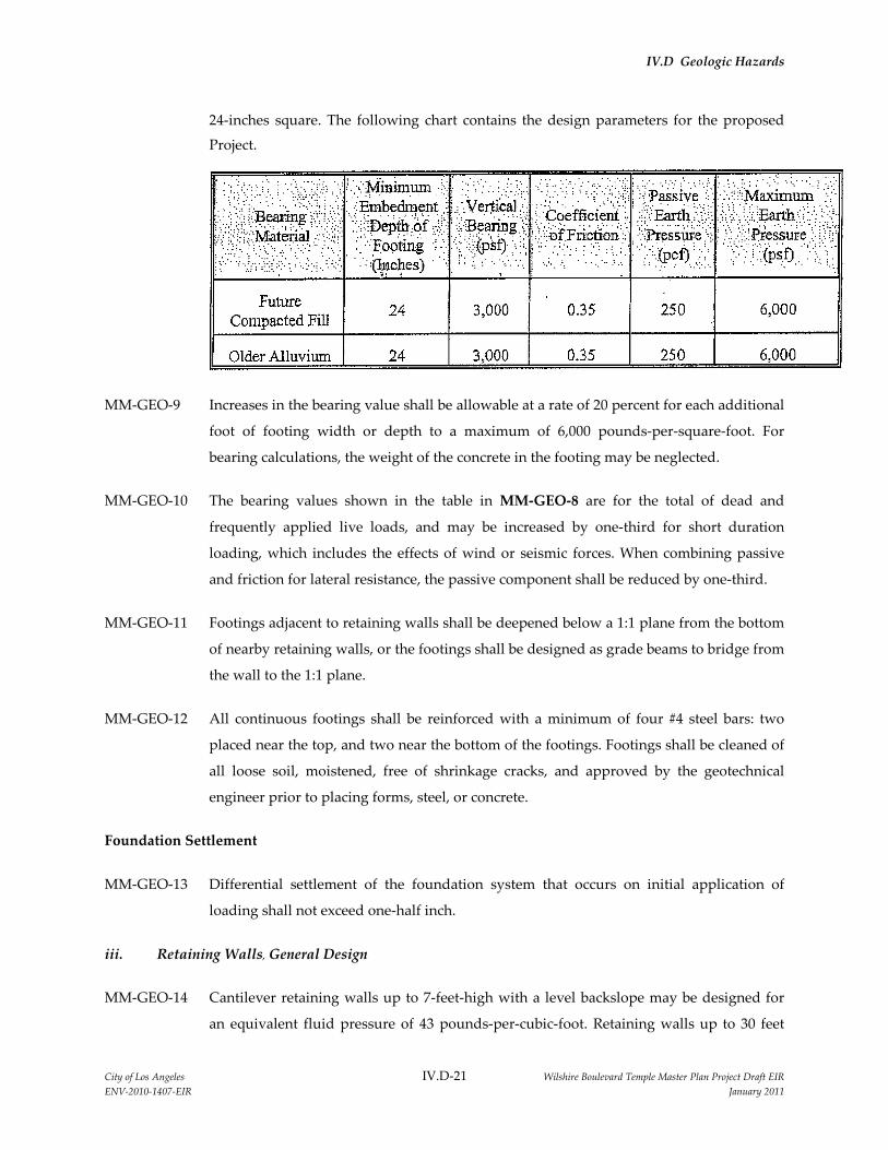
IV.D Geologic Hazards
City of Los Angeles IV.D-21 Wilshire Boulevard Temple Master Plan Project Draft EIR
ENV-2010-1407-EIR January 2011
24-inches square. The following chart contains the design parameters for the proposed
Project.
MM-GEO-9 Increases in the bearing value shall be allowable at a rate of 20 percent for each additional
foot of footing width or depth to a maximum of 6,000 pounds-per-square-foot. For
bearing calculations, the weight of the concrete in the footing may be neglected.
MM-GEO-10 The bearing values shown in the table in MM-GEO-8 are for the total of dead and
frequently applied live loads, and may be increased by one-third for short duration
loading, which includes the effects of wind or seismic forces. When combining passive
and friction for lateral resistance, the passive component shall be reduced by one-third.
MM-GEO-11 Footings adjacent to retaining walls shall be deepened below a 1:1 plane from the bottom
of nearby retaining walls, or the footings shall be designed as grade beams to bridge from
the wall to the 1:1 plane.
MM-GEO-12 All continuous footings shall be reinforced with a minimum of four #4 steel bars: two
placed near the top, and two near the bottom of the footings. Footings shall be cleaned of
all loose soil, moistened, free of shrinkage cracks, and approved by the geotechnical
engineer prior to placing forms, steel, or concrete.
Foundation Settlement
MM-GEO-13 Differential settlement of the foundation system that occurs on initial application of
loading shall not exceed one-half inch.
iii. Retaining Walls, General Design
MM-GEO-14 Cantilever retaining walls up to 7-feet-high with a level backslope may be designed for
an equivalent fluid pressure of 43 pounds-per-cubic-foot. Retaining walls up to 30 feet

IV.D Geologic Hazards
City of Los Angeles IV.D-22 Wilshire Boulevard Temple Master Plan Project Draft EIR
ENV-2010-1407-EIR January 2011
high are planned to support the excavation
of the subterranean portion of the proposed
parking structure. These walls, which shall
be restrained, shall be designed for the at-
rest lateral earth pressure of 38H, where H is
the height of the wall. The diagram
illustrates the trapezoidal distribution of
earth pressure. The design earth pressures
assume that the walls are free draining.
Where a traffic surcharge exists, defined by a
1:1 plane from the bottom of the excavation along the northern property line, adjacent to
6th Street, an additional horizontal force of 175 pounds-per-square-foot shall be applied
laterally to the wall. Retaining walls should be provided with a subdrain or weepholes
covered with a minimum of 12 inches of 0.75-inch crushed gravel. A sump pump shall be
required for the subdrain system if it is deemed necessary by the Project geotechnical
engineer.
iv. Backfill
MM-GEO-15 Retaining wall backfill shall be compacted to a minimum of 90 percent of the maximum
dry density as determined by ASTM D 1557-07, or equivalent. Where access between the
retaining wall and the temporary excavation prevents the use of compaction equipment,
retaining walls shall be backfilled with 0.75-inch crushed gravel to within 2 feet of the
ground surface. Where the area between the wall and the excavation exceeds 18 inches
the gravel shall be vibrated or wheel-rolled, and tested for compaction: The upper 2 feet
of backfill above the gravel shall consist of a compacted-fill blanket to the surface.
Restrained walls shall not be backfilled until the restraining system is in place.
v. Foundation Design
MM-GEO-16 Retaining wall footings shall be founded in the older alluvium and may be sized per the
“Spread Footings” section of the Comprehensive Geotechnical Engineering Exploration
Update #2 prepared by Byer Geotechnical, Inc., contained in Appendix IV.D of the Draft
EIR.

IV.D Geologic Hazards
City of Los Angeles IV.D-23 Wilshire Boulevard Temple Master Plan Project Draft EIR
ENV-2010-1407-EIR January 2011
vi. Retaining Wall Deflection
MM-GEO-17 Non-restrained retaining walls can deflect up to 1 percent of their height in response to
loading. This deflection is normal and results in lateral movement and settlement of the
backfill toward the wall. The zone of influence is within a 1:1 plane from the bottom of
the wall. Hard surfaces or footings placed on the retaining wall backfill shall be designed
to avoid the effects of differential settlement from this movement. Decking that caps a
retaining wall shall be provided with a flexible joint to allow for the normal deflection of
the retaining wall. Decking that does not cap a retaining wall shall not be tied to the wall.
The space between the wall and the deck shall be caulked to prevent moisture intrusion
into the retaining wall backfill as deemed necessary by the geotechnical engineer.
vii. Temporary Excavations
MM-GEO-18 Temporary excavations shall be required during grading to construct the proposed
buildings on the Project site. The excavations shall be up to 30 feet in height and will
expose fill over older alluvium. The fill shall be trimmed to 1:1 for wall excavations. The
older alluvium is capable of maintaining vertical excavations up to 5 feet high. Where
vertical excavations in the older alluvium exceed 5 feet in height, the upper portion shall
be trimmed to 1:1 (45 degrees).
MM-GEO-19 Vertical excavations adjacent to public right-of-way, or those removing support from
adjacent footings, shall require the use of shoring. Temporary shoring shall be designed
for an equivalent fluid pressure of 30 pounds-per-cubic-foot. Values can be found in the
“Shoring Piles” mitigation measures MM-GEO-21 and MM-GEO-22, below.
MM-GEO-20 The Project geologist shall be present during grading on the Project site to inspect
temporary slopes. All excavations shall be stabilized within 30 days of initial excavation.
Water shall not be allowed to pond on top of the excavations nor to flow toward them.
No vehicular surcharge shall be allowed within 3 feet of the top of the cut.
viii. Shoring Piles
MM-GEO-21 If drilled, cast-in-place concrete soldier piles are utilized as temporary shoring to support
the excavations for the subterranean portion of the proposed parking structure, the piles
shall be a minimum of 18 inches in diameter and a minimum of 8 feet into older alluvium
and below the excavation. Piles may be assumed fixed at 3 feet into older alluvium and
below the excavation. The piles shall be designed for a skin friction of 500 pounds-per-

IV.D Geologic Hazards
City of Los Angeles IV.D-24 Wilshire Boulevard Temple Master Plan Project Draft EIR
ENV-2010-1407-EIR January 2011
square-foot for that portion of pile in contact with the older alluvium and below the
excavation. Piles shall be spaced a maximum of 8 feet on center. Based upon the
calculation (Calculation Sheet No. 2 located in Appendix V of the Comprehensive
Geotechnical Engineering Exploration Update #2 prepared by Byer Geotechnical, Inc., in
Appendix IV.D of the Draft EIR), the shoring piles shall be designed for an equivalent
fluid pressure of 30 pounds-per-cubic-foot. The equivalent fluid pressure shall be
multiplied by the pile spacing. The piles may be included in the permanent retaining
wall. Where a combination of sloped embankment and shoring is used, the pressure will
be greater and shall be determined for each combination.
MM-GEO-22 Should groundwater be encountered in the pile excavations, it shall be pumped out, or
the water may be displaced by pumping concrete from the bottom with a hose. The tip of
the hose shall be kept at least 5 feet below the concrete surface during pumping. When
concrete is placed below water, the mix shall be adjusted to achieve at least 1,000 pounds-
per-square-inch more than the required strength.
ix. Tieback Anchors
MM-GEO-23 Tieback anchors may be used to resist lateral loads. Conventional, drilled friction anchors
or pressure-grouted anchors may be used. The active wedge adjacent to the shoring is
defined by a plane drawn at 35 degrees with the vertical through the bottom of the
excavation. The friction anchors shall extend at least 15 feet beyond the active wedge or
to a greater length if necessary to develop the desired resistance. For design purposes, it
is estimated that drilled friction anchors a minimum of 10 feet beyond the active wedge
will develop an average friction value of 700 pounds per square foot. Only the frictional
resistance developed beyond the active wedge will be effective in resisting lateral loads.
If anchors are spaced no closer than 6 feet, on center, no reduction in the capacity of the
anchors is necessary. The anchors may be installed at angles of 20 to 40 degrees below the
horizontal. Tieback anchors shall be tested during installation in accordance with the
specifications of the shoring engineer.
The friction value is for the total of dead and frequently applied live loads and may be
increased by one-third for short duration loading, which includes the effects of wind or
seismic forces. Resistance to lateral loading may be provided by passive earth pressure
within the older alluvium below the excavation.

IV.D Geologic Hazards
City of Los Angeles IV.D-25 Wilshire Boulevard Temple Master Plan Project Draft EIR
ENV-2010-1407-EIR January 2011
x. Lateral Design
MM-GEO-24 The maximum allowable earth pressure is 6,000 pounds per square foot. Passive earth
pressure may be computed as an equivalent fluid having a density of 250 pounds per
cubic foot. For design of isolated piles, the allowable passive and maximum earth
pressures may be increased by 100 percent. Piles spaced more than 2.5-pile diameters on
center shall be considered isolated.
xi. Lagging
MM-GEO-25 Continuous lagging is anticipated between the soldier piles. The soldier piles and
anchors shall be designed for the full-anticipated lateral pressure. However, the pressure
on the lagging will be less due to arching in the soils. Lagging shall be designed for the
recommended earth pressure, but may be limited to a maximum value of 400 pounds per
square foot.
xii. Deflection
MM-GEO-26 Some deflection of the shored embankment should be anticipated. Where shoring is
planned adjacent to existing structures, ateral deflection shall not exceed one-half inch.
For shoring not surcharged by a structure, the allowable deflection is deferred to the
Project structural engineer. If greater deflection occurs during construction, additional
bracing or anchors shall be utilized, as necessary, to minimize deflection. If it is necessary
to reduce the deflection of the shoring, a greater active pressure could be used in the
shoring design.
xiii. Floor Slabs
MM-GEO-27 Floor slabs shall be cast over approved compacted fill or older alluvium in accordance
with the “Site Preparation - Removals” section of the Comprehensive Geotechnical
Engineering Exploration Update #2 prepared by Byer Geotechnical, Inc., contained in
Appendix IV.D of the Draft EIR or any subsequent recommendations that are made by
the Project's geotechnical engineers and/or the Department of Building and Safety. Floor
slabs shall be reinforced with a minimum of #4 bars on 16-inch centers, each way.
MM-GEO-28 Slabs that will be provided with a floor covering shall be protected by a polyethylene
plastic vapor barrier. The barrier shall be sandwiched between the layers of sand, about
2 inches each, to prevent punctures and aid in the concrete cure. A low-slump concrete

IV.D Geologic Hazards
City of Los Angeles IV.D-26 Wilshire Boulevard Temple Master Plan Project Draft EIR
ENV-2010-1407-EIR January 2011
may be used to minimize possible curling of the slab. The concrete shall be allowed to
cure properly before placing vinyl or other moisture sensitive floor covering.
MM-GEO-29 Prior to the placement of concrete slabs on expansive soils, the subgrade shall be pre-
moistened until the moisture content reaches at least 120 percent of the optimum
moisture content to a depth of 12 inches. The pre-moistened soils shall be tested and
verified to be 120 percent of optimum moisture content, prior to pouring.
ix. Exterior Concrete Decks
MM-GEO-30 Decking shall be cast over approved compacted fill placed in accordance with the “Site
Preparation - Removals” section of the Comprehensive Geotechnical Engineering
Exploration Update #2 prepared by Byer Geotechnical, Inc., contained in Appendix IV.D
of the Draft EIR or any subsequent recommendations that are made by the Project's
geotechnical engineers and/or the Department of Building and Safety. Decking shall be
reinforced with a minimum of 43 bars placed 24 inches on center, each way. Decking that
caps a retaining wall shall be provided with a flexible joint to allow for the normal one to
2 percent deflection of the retaining wall. Decking that does not cap a retaining wall shall
not be tied to the wall. The space between the wall and the deck shall be periodically
caulked as determined by the geotechnical engineer to prevent moisture intrusion into
the retaining wall backfill. The subgrade shall be moistened prior to placing concrete.
xiv. Drainage
MM-GEO-31 Control of Project site drainage to optimize the performance of the proposed Project shall
be required. Pad and roof drainage shall be collected and transferred to the street or
approved location in non-erosive drainage devices. Drainage shall not be allowed to
pond on the pad or against any foundation or retaining wall. Planters located within
retaining wall backfill shall be sealed to prevent moisture intrusion into the backfill.
Planters located next to raised-floor-type construction also shall be sealed to the depth of
the footings. Drainage control devices shall be periodically cleaned, tested, and
maintained to remain effective.

IV.D Geologic Hazards
City of Los Angeles IV.D-27 Wilshire Boulevard Temple Master Plan Project Draft EIR
ENV-2010-1407-EIR January 2011
Irrigation
MM-GEO-32 Irrigation water shall be controlled as a necessary part of Project site maintenance. Soggy
ground and perched water may result if irrigation water is excessively applied. Irrigation
systems shall be adjusted to provide the minimum water needed. Adjustments shall be
made for changes in climate and rainfall.
Infiltration Pit
MM-GEO-33 The roof and pad drainage shall be conducted to the street in order to avoid geotechnical-
related damage and because the fine-grained subsurface soils on the Project site have
very low percolation characteristics.
xv. Waterproofing
MM-GEO-34 Interior and exterior retaining walls shall be waterproofed to avoid damage from
moisture intrusion, seepage, and leakage. Waterproofing paints, compounds, or sheeting
can be effective if properly installed. Equally important is the use of a subdrain that
daylights to the atmosphere. The subdrain shall be covered with 0.75-inch crushed gravel
to help the collection of water. Landscape areas above the wall shall be sealed or properly
drained to prevent moisture contact with the wall or saturation of wall backfill.
xvi. Plan Review
MM-GEO-35 The geotechnical engineer shall review grading, foundation and shoring plans prior to
finalization to verify that the plans have been prepared in substantial conformance with
the recommendations in the Comprehensive Geotechnical Engineering Exploration
Update #2 prepared by Byer Geotechnical, Inc., contained in Appendix IV.D of the Draft
EIR or any subsequent recommendations that are made by the geotechnical engineer
and/or the Department of Building and Safety, and to provide additional analyses or
recommendations, if necessary.
xvii. Site Observations During Construction
MM-GEO-36 The Foundation excavations shall be observed and approved by the geotechnical
engineer prior to placing steel, forms, and concrete. The engineer shall observe bottoms
for fill, compaction of fill, pile excavations, slot cutting, subdrains, and retaining wall
backfill. All fill that is placed shall be approved by the geotechnical engineer and the Los

IV.D Geologic Hazards
City of Los Angeles IV.D-28 Wilshire Boulevard Temple Master Plan Project Draft EIR
ENV-2010-1407-EIR January 2011
Angeles Department of Building and Safety prior to use for support of structural footings
and floor slabs.
MM-GEO-37 The geotechnical engineer shall be advised at least 24 hours prior to any required site
visit to the Project site. The plans stamped by the Los Angeles Department of Building
and Safety, the permits, and the geotechnical reports shall be located at the Project job site
and available to the geotechnical engineer. The Project geotechnical engineer shall
perform the observation and post a notice at the Project site with the findings. This notice
shall be given to the City of Los Angeles Department of Building and Safety inspector.
xviii. Final Reports
MM-GEO-38 The geotechnical engineer shall prepare final compaction reports upon request. The
project geologist shall prepare reports summarizing pile excavations.
xix. Construction Site Maintenance
MM-GEO-39 It shall be the responsibility of the contractor to maintain a safe construction site. The
construction area on the Project site shall be fenced and warning signs posted. All
excavations shall be covered and secured. Soil generated by foundation excavations shall
be either removed from the Project site or placed as compacted fill. Soil shall not be
spilled over any descending slope. Workers shall not be allowed to enter any unshored
trench excavations over 5 feet deep. Water shall not be allowed to saturate open footing
trenches.
xx. Plan Review
MM-GEO-40 The Project geologist shall review grading, foundation and shoring plans prior to
finalization to verify that the plans have been prepared in substantial conformance with
the recommendations in the Comprehensive Geotechnical Engineering Exploration
Update #2 prepared by Byer Geotechnical, Inc., dated June 18, 2010 and provided in
Appendix IV.D of the Draft EIR, and to provide additional analyses or
recommendations, if necessary.
f. Unavoidable Significant Impacts
The proposed Project would be designed and constructed in accordance with all applicable requirements
contained in the most current editions of the California Building Code and the Los Angeles Uniform
Building Code, as well as applicable provisions of Chapter IX, Division 70 of the Los Angeles Municipal

IV.D Geologic Hazards
City of Los Angeles IV.D-29 Wilshire Boulevard Temple Master Plan Project Draft EIR
ENV-2010-1407-EIR January 2011
Code, which addresses grading, excavation, and fill. With implementation of mitigation measures
MM-GEO-1 through MM-GEO-40 to mitigate potentially significant impacts associated with geologic
hazards and sedimentation and erosion, impacts related to the construction and operation of the
proposed Project would be less than significant.
g. Cumulative Impacts
As discussed in Section III, General Description of Environmental Setting, several related projects are
proposed and/or planned within the vicinity of the Project site. Potential geologic hazards associated with
the proposed Project are site-specific and would not contribute to cumulative impacts. Implementation of
the proposed Project and other projects in the Southern California region would cumulatively increase
the number of structures and people exposed to geologic- and seismic-related hazards. However,
geologic impacts associated with individual sites do not add to geologic impacts on other sites. As long as
design and construction of related projects occurs consistent with proper engineering practices and in
accordance with the requirements outlined in the latest addition of the California Building Code and the
Los Angeles Uniform Building Code, including all applicable provisions of Chapter IX, Division 70 of the
Los Angeles Municipal Code, seismic and regional geologic hazards would not be considered
cumulatively considerable. As such, it is anticipated that the proposed Project, considered together with
related projects, would not result in cumulatively significant geologic hazard impacts.