IV. Existing Conditions and Site Analysis
42
GLA VA Campus Draft Master Plan Section IV. Existing Conditions and Site Analysis IV.1 IV. Existing Conditions and Site Analysis Contents IV. Existing Conditions and Site Analysis ............................................................................... IV.1 A. Historic Growth Patterns ................................................................................................ IV.3 B. Regional Context............................................................................................................ IV.6 Connection of GLA Campus with Satellite Sites .............................................................. IV.6 Surrounding Roads & Access Points............................................................................... IV.8 Transit & Proximity .......................................................................................................... IV.8 Public Transportation ...................................................................................................... IV.8 Surrounding Neighborhoods and Land Uses................................................................. IV.10 C. Site Analysis ................................................................................................................ IV.12 Introduction ................................................................................................................... IV.12 Site Definition................................................................................................................ IV.12 Existing Infrastructure and Utilities ................................................................................ IV.12 Topography................................................................................................................... IV.12 Natural Areas ................................................................................................................ IV.13 Open Space .................................................................................................................. IV.16 Primary Roadways ........................................................................................................ IV.18 Bicycles ........................................................................................................................ IV.19 Onsite Parking .............................................................................................................. IV.21 Existing Building Inventory ............................................................................................ IV.24 Greater Los Angeles Veterans Affairs Historic District .................................................. IV.29 Existing Regulatory Requirements ................................................................................ IV.30 NEPA and NHPA Due Diligence ................................................................................... IV.32 Inactive Waste Burial Site ............................................................................................. IV.32 Responsive Site Design & Climate Analysis.................................................................. IV.32 Site-Responsive Strategies for this Climate Zone ......................................................... IV.37 D. Opportunities and Constraints ...................................................................................... IV.39 Assets ........................................................................................................................... IV.39 Challenges .................................................................................................................... IV.39 Opportunities ................................................................................................................ IV.40 Conclusion .................................................................................................................... IV.42
Transcript of IV. Existing Conditions and Site Analysis

GLA VA Campus Draft Master Plan Section IV. Existing Conditions and Site Analysis
IV.1
IV. Existing Conditions and Site Analysis Contents IV. Existing Conditions and Site Analysis ............................................................................... IV.1
A. Historic Growth Patterns ................................................................................................ IV.3
B. Regional Context ............................................................................................................ IV.6
Connection of GLA Campus with Satellite Sites .............................................................. IV.6
Surrounding Roads & Access Points ............................................................................... IV.8
Transit & Proximity .......................................................................................................... IV.8
Public Transportation ...................................................................................................... IV.8
Surrounding Neighborhoods and Land Uses ................................................................. IV.10
C. Site Analysis ................................................................................................................ IV.12
Introduction ................................................................................................................... IV.12
Site Definition ................................................................................................................ IV.12
Existing Infrastructure and Utilities ................................................................................ IV.12
Topography ................................................................................................................... IV.12
Natural Areas ................................................................................................................ IV.13
Open Space .................................................................................................................. IV.16
Primary Roadways ........................................................................................................ IV.18
Bicycles ........................................................................................................................ IV.19
Onsite Parking .............................................................................................................. IV.21
Existing Building Inventory ............................................................................................ IV.24
Greater Los Angeles Veterans Affairs Historic District .................................................. IV.29
Existing Regulatory Requirements ................................................................................ IV.30
NEPA and NHPA Due Diligence ................................................................................... IV.32
Inactive Waste Burial Site ............................................................................................. IV.32
Responsive Site Design & Climate Analysis .................................................................. IV.32
Site-Responsive Strategies for this Climate Zone ......................................................... IV.37
D. Opportunities and Constraints ...................................................................................... IV.39
Assets ........................................................................................................................... IV.39
Challenges .................................................................................................................... IV.39
Opportunities ................................................................................................................ IV.40
Conclusion .................................................................................................................... IV.42

GLA VA Campus Draft Master Plan Section IV. Existing Conditions and Site Analysis
IV.2
Table of Figures Figure IV-1: 1894 and 1925 Historic Growth Maps ................................................................................... IV.3 Figure IV-2: 1934 and 1947 Historic Growth Maps ................................................................................... IV.4 Figure IV-3: 1972 and 1989 Historic Growth Maps ................................................................................... IV.5 Figure IV-4: Regional Context ................................................................................................................... IV.6 Figure IV-5: VA Greater Los Angeles Medical Center Location ............................................................... IV.7 Figure IV-6: Neighborhood Context ........................................................................................................IV.11 Figure IV-7: Topography .........................................................................................................................IV.15 Figure IV-8: Existing Open Space ...........................................................................................................IV.17 Figure IV-9: Existing Roadwork ..............................................................................................................IV.19 Figure IV-10: Existing Parking ................................................................................................................IV.23 Figure IV-11: Existing Buildings ..............................................................................................................IV.28 Figure IV-12: Greater Los Angeles VA National Register Historic District .............................................IV.31 Figure IV-13: GLA Optimal Solar Orientation ..........................................................................................IV.34 Figure IV-14: GLA Natural Ventilation (NV) Potential Wind Rose ..........................................................IV.35 Figure IV-15: Dry Bulb Temperature and Degree Days ..........................................................................IV.36 Figure IV-16: Natural Ventilation (NV) Potential Wind Rose and Precipitation / Relative Humidity .......IV.36 Figure IV-17: Load Reduction (Daylight and Solar Considerations) .......................................................IV.38

GLA VA Campus Draft Master Plan Section IV. Existing Conditions and Site Analysis
IV.3
A. Historic Growth Patterns Maps and aerial photographs tell the story of the Soldier’s Home from its inception over a century ago. Images of the campus from 1894 show minimal roads and only a few buildings. At the time, two main roads crossed through the GLA campus in 1894. Bonsall Avenue was a main route through the campus from Wilshire Boulevard extending north along the bluff to existing campus borders on the North side. A small cluster of buildings surrounded a road loop just north of Wilshire Boulevard. The road extended south to cross Wilshire Boulevard to a small collection of buildings east of what is today Wadsworth Park. There is evidence of a train rail that entered the campus from the south. The railway ended in a loop just north of Wilshire in the area that is now the 405 on-ramp. Figure IV-1: 1894 and 1925 Historic Growth Maps
By 1925, the campus had greater access through rail. The railway serviced the south eastern side of campus. A new east-west running line was introduced south of Ohio Ave. From this rail line another line extended North through the campus, running along San Vincente Blvd. At this time, San Vicente Blvd cut through the Grand Lawn to Wilshire Boulevard. At the edge of the GLA campus, there was a short rail line that turned back into the interior of the campus and ended at the Trolley Depot that still exists on campus today. A map from 1925 is also the last evidence of an access point at the north end of the campus. Bonsall Avenue extended through the north borders of the campus and connected to a west-bound Sunset Boulevard. Later maps show Bonsall Avenue coming to a stop within the north campus. At that time, other access points to the campus included the western access point

GLA VA Campus Draft Master Plan Section IV. Existing Conditions and Site Analysis
IV.4
through Constitution Avenue. Over the next two decades, the campus went through tremendous change, most likely due to the two World Wars. First, the campus developed in density within the existing neighborhood north of Wilshire Boulevard. By 1934, maps show many buildings that still exist today including the research buildings 115, 117, 113, and 114 as well as building 116 and the Mess Hall, Building 13. By 1947, the campus development had expanded north. A new road network was formed on the northern plateau of the campus creating more fan-like arrangement of streets. Although Bonsall Ave came to an end in this area, a new road was constructed, winding through the varying topography and extending out the northern limits of the campus and connect to what is today Barrington Avenue. More homes had been constructed along these roads including buildings 205, 208 and 209, aligned with buildings to the south and creating the quad that can be seen today. Figure IV-2: 1934 and 1947 Historic Growth Maps
By the 1950s, all rail in or around the campus had been eliminated and the focus of transportation has turned to the car. By the early 60s, I-405 was being used as a major throughway just east of the GLA campus. Maps from 1964 show that Wilshire Boulevard’s dramatic widening to meet the traffic demand of the area. By 1964, there was also increased development on the north end of the campus. The northern most access point onto Barrington Place had been eliminated and the campus road system was constructed into a loop that encircled the plateau-like area west of the Golf course.

GLA VA Campus Draft Master Plan Section IV. Existing Conditions and Site Analysis
IV.5
The 1972 map of the campus shows an access point added to the west side of campus and east into a central point in the campus along the bluff line. At this time, the south campus road system begins to break from the linear roads that had existed, as seen in Figure IV-3, when Bonsall Avenue had continued through the South campus to meet Ohio Avenue. By 1989, Bonsall Avenue had been interrupted and transformed into a half circle and by 2002 the road system of the South campus is how we know it today. Figure IV-3: 1972 and 1989 Historic Growth Maps

GLA VA Campus Draft Master Plan Section IV. Existing Conditions and Site Analysis
IV.6
B. Regional Context The VA Greater Los Angeles Healthcare System (VAGLAHS) is one of the largest healthcare systems within VA. It is a key component of the VA Desert Pacific Healthcare “VISN” 22 (Veterans Integrated Service Network), offering services to Veterans residing in Southern California and Southern Nevada. VAGLAHS consists of three ambulatory care centers, a tertiary care facility, and 10 community-based outpatient clinics. VAGLAHS serves Veterans residing throughout five counties: Los Angeles, Ventura, Kern, Santa Barbara, and San Luis Obispo. There are 1.4 million Veterans in the VAGLAHS service area. VAGLAHS is affiliated with both UCLA School of Medicine and USC School of Medicine. (See Figures IV-4 and IV-5).
Centrally located in West Los Angeles, North of Interstate 10 and West of Interstate 405
Bus route and proposed Metro extension along Wilshire Boulevard
Los Angeles International Airport located 10 miles south.
UCLA Ronald Reagan Hospital less than 10 minutes away
USC Health Sciences Campus 20 minutes away, USC Main Campus 15 minutes away
Figure IV-4: Regional Context
Connection of GLA Campus with Satellite Sites The GLA Campus, when revitalized, will become a more meaningful, inviting, and welcoming resource to a broad range of Veterans in Southern California. It will also function more strategically with satellite sites, such as the Sepulveda Ambulatory Care Center, the LA Ambulatory Care Center, and all 10 Community-Based Outpatient Clinics as well as sites that help serve Veterans as partners in healthcare, housing and human services.

GLA VA Campus Draft Master Plan Section IV. Existing Conditions and Site Analysis
IV.7
Figure IV-5: VA Greater Los Angeles Medical Center Location

GLA VA Campus Draft Master Plan Section IV. Existing Conditions and Site Analysis
IV.8
Surrounding Roads & Access Points The GLA Veterans Affairs campus is located at the major intersection of Sepulveda Boulevard, Interstate 405 (also known as the San Diego Freeway), and Wilshire Boulevard in Los Angeles, California, and is generally bounded by Barrington Avenue, Bringham Avenue, San Vicente Boulevard and Federal Avenue on the west; Ohio Avenue on the south; and Veteran Avenue on the east. Located in the densely urbanized Brentwood neighborhood, the campus encompasses approximately 388 acres and retains a strong sense of time and place from the period between 1923 to 1952, when it was used as a Second Generation Veterans Hospital. Wilshire Boulevard begins in the City of Santa Monica and continues easterly into Downtown Los Angeles. It extends through GLA Campus and serves as its primary access. In the GLA Campus vicinity, Wilshire Boulevard is striped with three travel lanes per direction, with left-turn channelization. Generally, within the City of Los Angeles, the eastbound and westbound curb lanes are restricted to bus and right-turn-only operation during the weekday morning and afternoon peak periods. Wilshire Boulevard is grade-separated over Bonsall Avenue, with on / off-ramps accessing Bonsall Avenue. Wilshire Boulevard also has northbound and southbound ramp connections with I-405. The I-405 / San Diego Freeway runs north-south from the northern San Fernando Valley, through Los Angeles County, and into Orange County. It is adjacent to the GLA Campus on the east and provides primary regional access to the site. It generally has four lanes, along with a high-vehicle occupancy lane, in each direction. Near the GLA Campus, I-405 runs north-south, interchanges with I-10 / Santa Monica Freeway, and has full or partial ramp connections at Sunset Boulevard, Wilshire Boulevard and Santa Monica Boulevard. According to current information on the Caltrans website, I-405 has an average daily traffic volume of 279,000 to 300,000 vehicles near Wilshire Boulevard.
Transit & Proximity Located at 11301 Wilshire Boulevard, West Los Angeles, California, the campus is 4 miles from downtown Santa Monica and 14 miles from downtown Los Angeles. The campus shares an edge with the Brentwood neighborhood on the west and to its north, with the Westwood neighborhood and the I-405 freeway on the east, and the West Los Angeles neighborhood on the south. Santa Monica is the nearest downtown area.
Public Transportation There is a network of existing public transportation serving the campus and surrounding area. Multiple regional and local public transportation operators include Metro, Santa Monica Big Blue Bus, Culver City Bus, Los Angeles Department of Transportation (LADOT) Commuter Express, and Antelope Valley Transit Authority. The bus lines that run along Wilshire Boulevard including the #4 San Vicente Boulevard, #3 Montana Avenue, #720 Metro Rapid Line, #2 Wilshire Boulevard, and #20 Metro Local Line. The commute into downtown Santa Monica is 16 minutes by car, 19 minutes by bus, 21 minutes by bike, and over an hour by foot. However, there are only two lines that actually enter the GLA campus. The first is the LADOT Commuter Express line that runs down Sepulveda Blvd, and enters the low lands of the eastern side of campus to service. The second is the Santa Monica Big Blue Bus, which travels through the south campus from Wilshire Boulevard to Ohio Avenue.A map of the bus routes described above, Figure B-2 Bus Lines and Bikeways is included in Appendix B.

GLA VA Campus Draft Master Plan Section IV. Existing Conditions and Site Analysis
IV.9
Page is intentionally left blank.

GLA VA Campus Draft Master Plan Section IV. Existing Conditions and Site Analysis
IV.10
Surrounding Neighborhoods and Land Uses Zoning and Uses on the GLA Campus:
The north campus is part of the GLA Campus for the GLA Healthcare System and is zoned as Institutional / Government Owned.
Government Owned. (See “Figure B-11 North Campus Zoning” in Appendix B).
Neighborhoods and Uses: The Los Angeles National Cemetery is to the east of the I-405 and is accessed via
Constitution Avenue. It currently contains 85,000 casket burials of Veterans and their family members, from the Mexican War to the present.
The north campus surrounding land use includes two multi-unit residential neighborhoods, with supporting commercial and retail buildings along the western and northern boundary.
The northeast is bordered by single-family homes (Brentwood Glen). Brentwood Village, a small commercial district at Barrington and Sunset, has more than a dozen restaurants, and coffee shops.
Western San Vicente Boulevard has two grocery stores and numerous other shops, restaurants and cafes within walking distance of the VA campus.
Sawtelle unincorporated, which is now owned partially by the federal government, state of California, and a private utility company, is under the zoning control of the Los Angeles County Board of Supervisors. This unincorporated area contains the Wilshire Federal Building, the Los Angeles National Cemetery for Veterans, the Wadsworth VA Hospital / GLA Medical Center, the site of a former major Veterans home, and many smaller federal office buildings.
Sawtelle incorporated, which borders the southern Medical Campus south of Wilshire Boulevard, is a district of Los Angeles that began when the Pacific Land company purchased land just to the south of the Veterans campus to develop a new town. Residential lots were sold based on their proximity to the “beautiful Soldier’s Home” to many Veterans and their families who were drawing services from the institution, which linked the Sawtelle community to the old Veterans home. The main street of Sawtelle Oregon Avenue, now called Santa Monica Boulevard, was served by a streetcar that connected the city to Los Angeles and had a branch that terminated on the GLA VA Campus.
The surrounding neighborhood uses described above are shown in “Figure IV-6 Neighborhood Context” on the following page.

GLA VA Campus Draft Master Plan Section IV. Existing Conditions and Site Analysis
IV.11
Figure IV-6: Neighborhood Context

GLA VA Campus Draft Master Plan Section IV. Existing Conditions and Site Analysis
IV.12
C. Site Analysis Introduction The following Site Analysis for the north campus summarizes the existing available record data information for the surrounding areas:
Parcel data
Environmental Context, including topography, natural areas, existing trees, native and naturalized plants, sensitive species, seismic activity, fault lines, liquefaction zones, soil conditions, flood hazards, rainfall, water tables, and aircraft flight patterns
Open spaces and active recreational uses on campus
Existing roadways, transit, and bicycle access on campus
Existing parking
Existing buildings
Greater Los Angeles Veterans Affairs Historic District
Existing Regulatory Requirements
Legislative Overlay
Pending NEPA and Historic Due Diligence
Site Climate Information, including site responsive design strategies for this area’s climate zone
This information is then summarized in the “Opportunities and Constraints” section. The information provided for the site was based on record data provided by the VA Hospital, local agency records, and the public GIS database for the Greater Los Angeles region.
Site Definition The 388 acre GLA campus is located just west of the Interstate 405 freeway (I-405) and both north and south of Wilshire Boulevard. The northern and western property borders Brentwood and West Los Angeles, and the east is bordered by Westwood and Century City, directly east of the I-405. The following parcel exhibit identifies parcels on or adjacent to the campus that are not owned by VA, including the California Veterans Home, U.S. Post Office, and the US Air Force, US Army, and California National Guard Property along Federal Avenue.
Existing Infrastructure and Utilities A full study and evaluation of the campus civil utilities can be found in Appendix B, and includes additional information regarding electrical facilities, telecommunications, gas, water, sewer and steam lines, and storm drain facilities.
Topography The campus site is north of Wilshire Boulevard and west of Interstate 405, located on a gently sloping terrace at the foot of the Santa Monica Mountains. Topographically, the site slopes from high on the north to low to the south as well as westerly from Bonsall Avenue (center of the site) to San Vicente Boulevard/Bringham Avenue, with elevations ranging from approximately 470 feet above mean sea level (MSL) to approximately 250 feet MSL. Along the east side of Bonsall Avenue, the existing topography slopes south to Wilshire Boulevard. Steep slopes up to

GLA VA Campus Draft Master Plan Section IV. Existing Conditions and Site Analysis
IV.13
approximately 30 feet in height descend from the western and northern edges of the campus, significantly impacting areas of potential development. Additional information about the topography can be found in Appendix B. A 22-acre parcel at the northern portion of the property is currently being used by the Brentwood School, and is at an elevation of approximately 480 feet. The southern portion of the north campus is at an elevation of approximately 310 feet. The change in elevation is approximately 170 vertical feet from the Brentwood School site to Wilshire Boulevard (see “Figure IV-7). The northern half of the property has more variation in topography, with existing site improvements that include large flat pad areas and graded side slopes to fit the existing terrain. The area is mostly used for recreational purposes and includes the following site improvements: football and track field, baseball fields, golf course, Veteran’s Park, soccer field, tennis courts, gardens, and the Arroyo drainage area. With these amenities, the density and paved areas are less than the southern portion and primarily used for parking and access drives. The southern half of the north campus accommodates the majority of the operating campus infrastructure. The southeast portion of the north campus has the least amount of elevation change and is primarily industrial, including laundry facilities, engineering shops, an oil lease area, and a supply warehouse.
Natural Areas Arroyo & Bluff The Arroyo in the northwesterly part of the campus is a designated intermittent blue line stream in the United States Geological Survey (USGS) classification of waters of the United States. This arroyo plays a role in the area’s site drainage, as conveyance for run-off from north to south, ultimately depositing into a culvert midway down the site. The tributary area and the arroyo course has been dramatically modified by natural and human means. With minimal intervention, the arroyo may be returned to a more natural form with naturalized grade and planting. A bluff is located on the eastern side of the campus. The bluff runs in a north south direction behind buildings 210, 209, 208 and 259. The property slopes downward approximately (60 feet) to the east border of the campus by the Brentwood/Westwood neighborhoods. With the arroyo on the western edge and the bluff located on the eastern edge, the land between these features acts as a plateau. The two topographic features are natural barriers that help create a protective are for housing and community development.
Existing Trees A tree survey was included in the design analysis to avoid negative impacts to existing tree cover. A linear grove of mature Eucalyptus trees along the southern portion of Bonsall Avenue form a buffer on the east edge of the VA Property. Located on the east of the arroyo another Eucalyptus grove forms a buffer on the west edge of the north campus. Historic Moreton Bay Fig (Ficus microphylla) groves are located throughout the site.
Native Plant Materials Located at the base of the Santa Monica Mountains, the project site is in the California chaparral and woodlands ecoregion of the California Floristic Province. This ecoregion has two predominant ecosystems, one coastal and one with chaparral and California oak woodlands at

GLA VA Campus Draft Master Plan Section IV. Existing Conditions and Site Analysis
IV.14
the project site. Chaparral is shaped by the Mediterranean climate, with its mild, wet winters and hot, dry summers and wildfire. The oak ecoregion includes Interior Live Oak, Tan Oak, Engelmann Oak, Canyon Live Oak, and Coast Live Oak. These native plants are highly flammable but very drought-tolerant, which is important given the current climate. Future landscaping efforts associated with new buildings should include xeriscaping techniques and native planting appropriate for the slope conditions and proximity to residential structures.
Sensitive Species The north campus is within the sensitive species area for the Monarch Butterfly, Silver-Haired Bat, Gertsch’s Socalchemmis Spider, Mud Nama (plant), and Braunton’s Milk-Vetch (plant).

GLA VA Campus Draft Master Plan Section IV. Existing Conditions and Site Analysis
IV.15
Figure IV-7: Topography

GLA VA Campus Draft Master Plan Section IV. Existing Conditions and Site Analysis
IV.16
Open Space Active Recreation Spaces The Heroes Golf Course located on the GLA campus is open from sun up to sun down, 7 days a week, and Veteran residents and inpatients receive first priority to use the course. Also existing within the campus boundaries are the athletic facilities and amenities at the Brentwood School (sports fields, track and tennis courts, and swimming pool), the Barrington Recreation Center and Park, and Jackie Robinson Stadium. (See Figure IV-8)
Community-Level Open Spaces These larger spaces exist already on campus for larger community events.
Formal Parade Grounds
Memorial (Rose) Garden
GLA Park Area
Wadsworth Historic Park
South Entry Lawn
Healing Garden
Arcadia’s Garden
Neighborhood Open Spaces These neighborhood-scale gathering and intermediate- level open spaces exist on campus currently.
Japanese garden
Buildings 205, 208, and 209 Quad
Open space between Buildings 214 and 217
Residential Gardens The best example of this scale of outdoor space on the existing campus is the New Directions for Veterans’ side yards and front patio entry. However most of the on-campus residential-scale landscaping surrounding existing buildings currently suffer from a lack of clear design intent and outdoor spaces for Veterans to use.
Existing Open Space Concerns: There are very few neighborhood-scale open spaces designated on the current campus with
appropriately scaled spaces and program.
Areas surrounding residential buildings do not take advantage of the opportunities for outdoor living spaces.
Benches and seating are placed haphazardly, and privacy from the street is not maintained.
Outdoor areas are not linked to sidewalks and the rest of the campus pedestrian circulation system.
Lacking comfortable spaces.
Use of natural shade.
Lack of separation between pedestrian and vehicular zones.

GLA VA Campus Draft Master Plan Section IV. Existing Conditions and Site Analysis
IV.17
Figure IV-8: Existing Open Space

GLA VA Campus Draft Master Plan Section IV. Existing Conditions and Site Analysis
IV.18
Primary Roadways The campus is divided in two parts: a northern section and a southern hospital section, by Wilshire Boulevard. Interstate 405 separates the campus from its National VA Cemetery. Both the northern and southern parts of campus are accessed primarily from Wilshire Boulevard in a deceleration lane that runs east and west. This deceleration lane descends to allow a tunnel underpass for Bonsall Avenue, connecting the two parts of campus. Other access points include points include:
The intersection of Sepulveda Boulevard and Constitution Avenue provides secondary access to the GLA Campus along the east side of I-405. Sepulveda Boulevard is one of the longest, continuous arterials in Los Angeles County, extending from the northern San Fernando Valley to the South Bay. It is generally striped with two travel lanes per direction, along with left-turn channelization. Constitution Avenue crosses under I-405 for both pedestrian and vehicular access to the National Cemetery.
The intersection of Sawtelle Boulevard and Ohio Avenue provides the primary access point for the south campus. Sawtelle Boulevard is a private street, with one through travel lane in each direction. Sawtelle Boulevard has one travel lane northbound and southbound between Ohio Avenue and Olympic Boulevard, with left-turn channelization at Olympic Boulevard. Ohio Avenue forms the southern boundary of the GLA Campus. It is striped with one travel lane per direction and a bike lane in the eastbound direction, with left-turn channelization installed at key intersections.
Eisenhower Avenue on the Bingham/San Vicente Boulevard side of campus, which is currently closed to vehicular traffic.
Pershing Avenue also intersects with Bingham Avenue on campus. Formerly used as a ‘back’ entry to the site for service functions, this entry is currently blocked off to both vehicular and pedestrian traffic.
In addition to Sawtelle Boulevard, on-site circulation is provided by a series of private streets. Bonsall Avenue serves as the primary north-south roadway for the GLA Campus. Bonsall Avenue extends northerly from Dowlen Drive on the South Campus, passes under Wilshire Boulevard, and continues northerly to MacArthur Avenue on the north campus. Dowlen Drive is a ring road on the South Campus, intersected by Bonsall Avenue on its northern perimeter and Sawtelle Boulevard on its southern perimeter, creating “East” and “West” segment designations. Dowlen Drive accesses all of the major parking lots and buildings on the south campus. Several streets on the north campus intersect and branch off Bonsall Avenue, including Eisenhower Avenue, Grant Avenue, Pershing Avenue and Nimitz Avenue. Generally, these private streets have two-way flow, one travel lane in each direction, and no on-street parking. All intersections on-site are stop-controlled, with most having all-way stops. There is currently no route for vehicular traffic to traverse the entire campus from south to north. (See Figure IV-9)

GLA VA Campus Draft Master Plan Section IV. Existing Conditions and Site Analysis
IV.19
Figure IV-9: Existing Roadwork

GLA VA Campus Draft Master Plan Section IV. Existing Conditions and Site Analysis
IV.20
Bicycles The campus currently contains few bicycle-friendly roads, with low traffic and gentle slopes. The City of Los Angeles adopted a Bicycle Plan as part of the transportation element of the city in 2011. The plan represents a commitment by the City of Los Angeles to complete streets as part of a move away from the auto- centric approach of the past toward a more sustainable transportation system that supports motor vehicle use, bicycling, walking, and transit.
The new Mobility Plan 2035, the city’s new 20-year transportation vision, prioritizes safety and alternatives to driving and lays out hundreds of miles of new bicycle lanes. Nearest to campus, the western portions of San Vicente Boulevard are Class II bike routes (on-street marked bike lanes) while the strip that borders campus, and roads on-campus, are Class III bike routes (streets with signs denoting that it is a bicycle route, may include sharrows). The VA campus could follow the lead of the City of Los Angeles and encourage the use of cycling on-campus as an alternative mode of transportation that supports Veteran health and community access by providing bicycle parking facilities, shared roadways, signage, protection, and campus access to do so.
Issues with existing circulation and access: Lack of way-finding and navigational signage.
Primary roadways are not designed to be main thoroughfares for pedestrians, bicycles or shuttles. They are not visually emphasized with identity-forming landscaping.
There are several areas on and around the campus where conflicts with vehicles are a safety hazard for pedestrians and cyclists. Some areas of concern are Eisenhower Avenue and Dewey Avenue, Dewey Avenue and Bonsall Avenue, crossing under Wilshire Boulevard to the south campus Medical Center, and crossing Barrington Ave to San Vicente Boulevard.
Pedestrian access is largely blocked at Pershing Avenue, and vehicular access is entirely blocked, which is the closest campus entry point for those who live in the CalVet building.
Accessibility is compromised due to topography challenges, lack of curb cuts, sidewalk conditions and width, safety lighting, traffic calming, and signage.
Current bike lanes do not connect through the campus. Nor is there a Veteran-centric program to encourage bike share and cycling as a means to transverse the very long campus. The lack of clear, on-campus bike routes leads to potential confusion and conflicts.

GLA VA Campus Draft Master Plan Section IV. Existing Conditions and Site Analysis
IV.21
Page is intentionally left blank.

GLA VA Campus Draft Master Plan Section IV. Existing Conditions and Site Analysis
IV.22
Onsite Parking Currently, most of the parking occurs in surface-level lots. (See Figure IV-10) In August 2015, VA conducted a parking inventory and parking utilization survey for the existing parking resources available on the North Campus. There are currently 1,882 parking spaces on the North Campus, excluding spaces for motorcycle parking and spaces leased to private entities. The survey found the peak parking utilization on the North Campus to be 1,212 spaces, leaving a surplus of 670 spaces. As part of the analysis of the proposed Bed Care Tower project, the parking supply on the South Campus was also inventoried. This inventory, conducted in October 2013, arrived at a parking supply of 2,023 spaces, excluding motorcycle and leased parking spaces. The study discovered “over capacity” conditions on the South Campus parking supply estimated the existing peak parking utilization to be approximately 2,225 spaces, i.e., approximately 10 percent more than the supply. The existing shuttle service is offered to patients and includes internal circulation as well as off campus sites such as the Sepulveda neighborhoods, a VA clinic in Downtown Los Angeles and the cities of Bakersfield, Santa Maria and Simi Valley. Long distance shuttle rides must be arranged in advance and is provided approximately one a day. For more information on the existing VA shuttle schedule see Appendix G.
Issues with existing parking: Too many surface parking lots scattered throughout the site, with no hierarchy.
Areas of asphalt visually dominate the campus experience.
Due to overabundance of surface parking substituting for secondary roadways, the campus circulation system is not clear.
Roads and parking should be secondary to pedestrian routes on campus.
Uneven distribution of parking creating parking congestion in some zones while other areas are unused.

GLA VA Campus Draft Master Plan Section IV. Existing Conditions and Site Analysis
IV.23
Figure IV-10: Existing Parking

GLA VA Campus Draft Master Plan Section IV. Existing Conditions and Site Analysis
IV.24
Existing Building Inventory An inventory of the existing buildings was made and can be found in the Appendix A. The inventory gives the facility types, building ages, building conditions and historic value of each built structure on campus. Aside from the Governor’s Mansion, the South campus is the more modern area of the campus. There, the two main medical facilities are less than 60 years old, surrounding buildings are even younger in age. Still, the hospital is in poor condition. Some of the mental health facilities on the South campus are in good condition. There are two buildings that are noted for lodging on the South campus that are also in good condition. The Ambulatory building, although aged, is in moderate condition. The North campus has a wide range of facility types represented on the North campus including administrative, mental health facilities, residential lodging with and without mental services, community living centers, research facilities, support and logistics, shared spaces and six vacant buildings are this time. Most of the structures on the North campus are more than 60 years old and are in poor condition. Current programmatic uses have been identified and categorized into eleven varying facility types that are presently distributed throughout the campus as a whole. While some buildings may be primarily dominated by a singular facility type, the majority of the existing occupied building inventory is comprised of multiple types. For ease of understanding, buildings are currently identified by their dominant facility type, but the square footage numbers provided are specific to only the area occupied by the facility type. It should be noted that the square footages also exclude areas designated as common spaces. The facility types are as listed below:
Administrative
Hospital
Ambulatory
Mental Health
Residential Mental Health
Residential Lodging
Community Living Center
Research
Support and Logistics
Vacant
Shared In this section facility types are more specifically defined with a breakdown of the programs and services that make up each of the facilities, as well as the square footages associated. Additionally, the dispersement of these facility types throughout the campus has been defined by the building locations, with buildings being specified when the facility category is the
primary designation. Each building is identified by number on the map found in Figure IV-11.
Administrative Departments and services breakdown: 1. Acquisition and Material Management
Warehouse Administration (3,434 ft²) a. Chaplain (5,094 ft²) b. Director’s Suite (17,033 ft²) c. Education (9,806 ft²) d. Fiscal (8,539 ft²) e. Human Resources (17,974 ft²) f. Library (1,901 ft²) g. Medical Administration (38,437
ft²) h. Medical Media (4,091 ft²) i. Medical Services Administration
(31,448 ft²) j. Nursing Services Administration
(10,497 ft²)

GLA VA Campus Draft Master Plan Section IV. Existing Conditions and Site Analysis
IV.25
k. Psychiatry Administration (4,462 ft²)
l. Social Work (2,154 ft²) m. Voluntary Service (1,951 ft²) n. VSO/Veteran Administration
(6,337 ft²) Square footage total – 163,158 ft² Location 1. Building 205 2. Building 218 3. Building 220 4. Building 258 5. Building 301 (primary designation) 6. Building 319 7. Building 401 8. Building 500
Hospital Departments and services breakdown: 1. Units – 23 Hour Observation (10,597 ft²) 2. Units – CCU (7,000 ft²) 3. Units – Intermediate (11,931 ft²) 4. Units – Medical (57,604 ft²) 5. Units – MH/Behavioral Medicine (48,726
ft²) 6. Units – MICU (6,325 ft²) 7. Units – Rehab (18,802 ft²) 8. Units – SICU (6,325 ft²) 9. Units – Surgical (15,665 ft²) 10. Pharmacy (7,013 ft²) 11. Surgical (54,140 ft²) Square footage total – 244,128 ft² Location 1. Building 304 2. Building 500 (primary designation)
Ambulatory Departments and services breakdown: 1. ACS – Primary Care (32,575 ft²) 2. ACS – Secondary Care (47,675 ft²) 3. Audiology (14,010 ft²) 4. Cardiology (15,482 ft²) 5. Dental (30,591 ft²) 6. Dialysis (16,981 ft²) 7. Digestive/Endoscopy (14,875 ft²) 8. EEG/Neurology (3,878 ft²)
9. Eye Clinic (16,545 ft²) 10. Geriatrics (6,802 ft²) 11. Home Based Healthcare (1,455 ft²) 12. Nuclear Medicine (9,780 ft²) 13. Pathology (30,046 ft²) 14. Pharmacy (4,016 ft²) 15. Prosthetics (10,300 ft²) 16. Pulmonary/Respiratory Care (6,797 ft²) 17. Radiation Therapy (11,455 ft²) 18. Radiology (19,971 ft²) 19. Rehab Medicine (17,740 ft²) Square footage total – 310,974 ft² Location 1. Building 213 2. Building 220 (primary designation) 3. Building 304 (primary designation) 4. Building 345 (primary designation) 5. Building 401 6. Building 500 7. Building 507 (primary designation)
Mental Health Departments and services breakdown: 1. Adult Day Care (4,478 ft²) 2. Day Hospital (2,188 ft²) 3. Day Treatment Center (9,599 ft²) 4. Mental Health Clinic (106,874 ft²) 5. Psychology (13,414 ft²) 6. Recreational Therapy (16,080 ft²) 7. Rehab Medicine (19,780 ft²) 8. Substance Abuse Clinic (13,666 ft²) Square footage total – 1586,079 ft² Location 1. Building 205 2. Building 206 (primary designation) 3. Building 208 (primary designation) 4. Building 210 5. Building 213 6. Building 249 (primary designation) 7. Building 256 (primary designation) 8. Building 257 9. Building 258 (primary designation) 10. Building 259 (primary designation) 11. Building 325 (primary designation) 12. Building 326 (primary designation) 13. Building 327 (primary designation) 14. Building 329 (primary designation)

GLA VA Campus Draft Master Plan Section IV. Existing Conditions and Site Analysis
IV.26
15. Building 332 (primary designation) 16. Building 333 (primary designation) 17. Building 334 (primary designation) 18. Building 401 (primary designation) 19. Building 402 (primary designation) 20. Building 512 (primary designation) 21. Building 515 (primary designation) 22. Building 518 (primary designation) 23. Building 521 (primary designation)
Residential Mental Health Departments and services breakdown: 1. Units – Domiciliary (142,032 ft²)
a. Domiciliary (DOM) b. PTSD Residential Rehabilitation
Treatment Program (PRRP) c. Psychosocial residential
rehabilitation treatment program (PRRTP)
d. Substance Abuse Residential Rehabilitation treatment Program (SARRTP)
e. Homeless Chronically Mentally Ill (HCMI)
Square footage total – 142,032 ft² Location 1. Building 209 (primary designation) 2. Building 214 (primary designation) 3. Building 217 (primary designation)
Lodging Departments and services breakdown: 1. Residential Quarters (28,847 ft²) Square footage total – 28,847 ft² Location 1. Building 523 (primary designation) 2. Building 535 (primary designation)
Community Living Center (CLC) Departments and services breakdown: 1. Units – CLC (NHCU) (69,869 ft²) Square footage total – 69,869 ft² Location 1. Building 213 (primary designation) 2. Building 215 (primary designation)
Research Departments and services breakdown: 1. Medical Research/Development
(262,705 ft²) Square footage total – 262,705 ft² Location 1. Building 113 (primary designation) 2. Building 114 (primary designation) 3. Building 115 (primary designation) 4. Building 117 (primary designation) 5. Building 208 6. Building 210 (primary designation) 7. Building 212 8. Building 220 9. Building 256 10. Building 258 11. Building 304 12. Building 337 (primary designation) 13. Building 340 (primary designation) 14. Building 342 (primary designation) 15. Building 346 (primary designation) 16. Building 500
Support/Logistics Departments and services breakdown: 1. Acquisition and Material Management
Warehouse (37,262 ft²) 2. Canteen Service (29,880 ft²) 3. Engineering (104,703 ft²) 4. Environmental Management (26,268 ft²) 5. Information Resource Management
(22,797 ft²) 6. Linen Service (1,840 ft²) 7. Nutrition/Food (48,382 ft²) 8. On-Site Laundry (49,584 ft²) 9. Pharmacy (10,362 ft²) 10. Police/Security (6,108 ft²) 11. Residential Quarters (19,578 ft²) 12. Social Work (116 ft²) 13. Sterile Process and Distribution Service
(21,092 ft²) Square footage totals – 377,972 ft² Location 1. Building 012 (primary designation) 2. Building 014 (primary designation)

GLA VA Campus Draft Master Plan Section IV. Existing Conditions and Site Analysis
IV.27
3. Building 023 (primary designation) 4. Building 033 (primary designation) 5. Building 044 (primary designation) 6. Building 046 (primary designation) 7. Building 063 (primary designation) 8. Building 090 (primary designation) 9. Building 091 (primary designation) 10. Building 113 11. Building 158 12. Building 199 13. Building 215G (primary designation) 14. Building 218 15. Building 222 (primary designation) 16. Building 231 (primary designation) 17. Building 233 (primary designation) 18. Building 236 (primary designation) 19. Building 256 20. Building 292 (primary designation) 21. Building 296 (primary designation) 22. Building 297 (primary designation) 23. Building 299 (primary designation) 24. Building 300 (primary designation) 25. Building 304 26. Building 305 (primary designation) 27. Building 306 (primary designation) 28. Building 307 (primary designation) 29. Building 308 (primary designation) 30. Building 309 (primary designation) 31. Building 310 (primary designation) 32. Building 311 (primary designation) 33. Building 312 (primary designation) 34. Building 315 (primary designation) 35. Building 318 (primary designation) 36. Building 319 (primary designation) 37. Building 500 38. Building 501 (primary designation) 39. Building 505 (primary designation) 40. Building 508 (primary designation) 41. Building 509 (primary designation) 42. Building 510 (primary designation) 43. Building 511 (primary designation) 44. Building 514 (primary designation) 45. Building 517 (primary designation) 46. Building 519 (primary designation) 47. Building 522 (primary designation) 48. T-83 (primary designation) 49. T-84 (primary designation)
Vacant These are buildings that are primarily unoccupied for various reasons.
Square footage total – 176,304,386 ft² Location 1. Building 013 (primary designation) 2. Building 020 (primary designation) 3. Building 066 (primary designation) 4. Building 111 (primary designation) 5. Building 156 (primary designation) 6. Building 157 (primary designation) 7. Building 158 (primary designation) 8. Building 199 (primary designation) 9. Building 205 (primary designation) 10. Building 208 11. Building 212 12. Building 258 13. Building 264 (primary designation)
Shared These are buildings that are primarily utilized by program elements that belong to entities outside of the VA system, usually through a sharing agreement. However, the Master Plan is based on direction from the VA to assume that the campus will not be encumbered by any existing land use agreements. Square footage total – 250,216 ft² Location 1. Building 114 2. Building 116 (primary designation) 3. Building 207 (primary designation) 4. Building 211 (primary designation) 5. Building 212 (primary designation) 6. Building 220 7. Building 224 (primary designation) 8. Building 226 (primary designation) 9. Building 257 (primary designation) 10. Building 258 11. Building 264 12. Building 301 (primary designation) 13. Building 306 14. Building 336 (primary designation) 15. Building 339 (primary designation) 16. Building 506 (primary designation) 17. American Red Cross (primary
designation)

GLA VA Campus Draft Master Plan Section IV. Existing Conditions and Site Analysis
IV.28
Figure IV-11: Existing Buildings

GLA VA Campus Draft Master Plan Section IV. Existing Conditions and Site Analysis
IV.29
Page is intentionally left blank.

GLA VA Campus Draft Master Plan Section IV. Existing Conditions and Site Analysis
IV.30
Greater Los Angeles Veterans Affairs Historic District In operation on the site since 1888, the Greater Los Angeles VA campus reflects the stories, service, and sacrifices of many generations of Veterans of the United States Armed Forces. In honor and recognition of this history, the National Park Service included the Greater Los Angeles VA Historic District on the National Register of Historic Places (NRHP) for its contribution to the “development of a national policy for Veteran healthcare” and as a “tangible manifestation of the federal government’s commitment to the healthcare of Veterans of World War I, which resulted in the nation’s largest network of hospitals.” The district has a cohesive grouping of Mission/Colonial Revival Style architecture and includes significant buildings and features that reflect the earliest era identified in the historic context statement for VA facilities nationwide, the National Home for Disabled Volunteer Soldiers.
Spanning nearly 400 acres, the designated Greater Los Angeles VA Historic District includes 66 contributing buildings and structures, as well as a unified site plan, landscape features, circulation paths and roads, and streetscapes, extending over four non-contiguous areas of the campus constructed in multiple phases. The 66 contributing (National Register-listed) features, include 55 buildings, 3 sites, 1 structure and 7 objects across the VA campus. In addition, within the boundaries of the historic district are another 44 noncontributing (ineligible) features, including 37 buildings, 1 site and 6 structures. The campus also has 2 resources individually listed on the National Register: Building 20 (Wadsworth Chapel) and Building 66 (Trolley Depot). (See Figure IV-12) Additional information about the Historic District can be found in Appendix D.
Existing Regulatory Requirements Existing conditions include requirements for compliance with regulations aimed at protecting historic resources. In accordance with the National Historic Preservation Act of 1966 (NHPA), as amended, VA must consider the reuse and preservation, where feasible, of historic properties, defined as properties included in or eligible for the National Register for Historic Places (NRHP). The NHPA also calls upon VA to consider the potential effects of any federally funded projects on historic properties. Pursuant to the National Environmental Policy Act (NEPA), Section 106 of the NHPA, and applicable VA policy, undertakings likely to result in an adverse effect to a historic property must be studied and efforts made to avoid, reduce, or mitigate adverse effects. Changes to the VA campus are subject to the Section 106 review process. This process can be greatly streamlined by building into the project design the avoidance and/or reduction of adverse effects through conformance with the Secretary of the Interior’s (SOI) Standards for the Treatment of Historic Properties. As codified in 36 CFR Chapter I, Part 68, following the SOI Standards generally allows a project to avoid adverse effects to historic properties. The SOI Standards offer guidelines and approaches for preserving, maintaining, repairing, and replacing historical materials and features, as well as designing additions or making alterations. Guidance is also provided for new construction adjacent to historic properties, to avoid diminution of integrity through a change in setting.

GLA VA Campus Draft Master Plan Section IV. Existing Conditions and Site Analysis
IV.31
Figure IV-12: Greater Los Angeles VA National Register Historic District

GLA VA Campus Draft Master Plan Section IV. Existing Conditions and Site Analysis
IV.32
NEPA and NHPA Due Diligence As a Federal agency, VA is required by the National Environmental Policy Act (NEPA) and the National Historic Preservation Act (NHPA) to identify and consider the potential impacts of its actions and decisions on the environment and historic properties, while providing for public consideration and input. VA plans to continue complying with NEPA and Section 106 of the NHPA following adoption of the Draft Master Plan. Input from external stakeholders, including the public, as part of the NEPA and Section 106 process will further contribute to the master planning process and the development of the Final Master Plan. This process and the requirements of the NHPA are discussed in more detail in Appendix D. Concurrent with the master planning process, VA began assessing its strategy for compliance with NEPA and the NHPA to ensure the greatest level of transparency and public involvement.
Inactive Waste Burial Site During the 1950s to approximately 1968, a medical waste burial site was operated within the VAGLAHS campus. During this period, medical waste resulting from historic medical research and facility operations was buried in distinct burial pits in the Arroyo area. Additionally, incinerator ash, presumably from medical sources, as well as miscellaneous medical debris, was buried in and north of the Arroyo. The site has been inspected and assessed on numerous occasions over the last 35 years. Due to the presence of low-level medical radiological waste, VAGLAHS notified the Nuclear Regulatory Commission (NRC) of the site in September, 1996, and complied with applicable regulatory requirements. Determinations have been made by State and Federal agencies that the site presents no public harm. In response to questions and concerns from the public regarding the site, VA completed a Phase I and Phase II Study of the area. The Phase I Study was completed in February, 2007. Results were released to the public and showed no levels of radiation that could be considered dangerous to the public. The Phase II Study was completed in December 2010. Once again, results were released to the public. The Phase II Study concluded that contaminants and radionuclides found in the soil and water did not exceed Preliminary Remediation Goals established for soil and tap water by the U.S. Environmental Protection Agency Region IX (USEPA Region IX). Additionally, contaminant and radionuclide concentrations in groundwater did not exceed Maximum Contaminant Levels established for drinking water by the California Department of Public Health. (The Phase II report can be found at http://www.losangeles.va.gov/LOSANGELES/features/GLA-Phase-II-Study.asp) To date, VAGLAHS has fully complied with all applicable laws and regulations related to this inactive medical waste burial site and, after thorough investigation, has not identified any potential health risks associated with the site. VAGLAHS is required to obtain NRC approval for any change in status of this site. As VAGLAHS proceeds in the master planning process, VAGLAHS will further consider potential impacts associated with the draft master plan and the waste burial site in its National Environmental Policy Act (NEPA) analysis.
Responsive Site Design & Climate Analysis Responsive site design takes into consideration the path of the sun, the rush of the wind, and the flow of water across the campus. The following factors were taken into consideration during the climate analysis of the site.

GLA VA Campus Draft Master Plan Section IV. Existing Conditions and Site Analysis
IV.33
Dry Bulb Temperatures The campus is located in the warm-marine climate zone characterized by mild temperatures, including warm summers, cool winters, and lack of precipitation. The Pacific Ocean is relatively warm and keeps the climate very mild. Average temperatures are in the low 60s Fahrenheit. (See Figure IV-15)
Degree Days Degree days are designed to reflect the demand for energy needed to heat or cool a building. It is derived from a measurement of the outside temperature, per hour, which is subtracted from a mean temperature of 65 degrees Fahrenheit. The resulting positive or negative number reflects the number of heating or cooling days a building requires. West Los Angeles has significantly more cooling degree days (4,390) than heating degree days (1,527). As a result, buildings require cooling more often than heating. (See Figure IV-15)
Solar Orientation Optimum site orientation provides maximum winter solar collection as well as maximum summer solar protection, which helps to extend the typically moderate temperatures further into the day. The optimum solar orientation is 10.5 degrees from north toward the east. (See Figure IV-13)
Wind Summers are pleasantly cooled by ocean winds. Though these offshore winds bring high humidity, comfort is maintained because of the relatively low temperatures. During the winter, the wind reverses and brings hot, dry desert air known as Santa Ana winds. Ocean breezes are typically strongest later in the evening, and in the winter, winds from the Santa Ana mountain range may bring unwanted heat and dust. (See Figure IV-16)
Precipitation Most rain falls during warm, mild winters. West Los Angeles receives little rainfall, and most of it occurs in January, February, and March. The summer months receive almost no rainfall, which can be particularly problematic during periods of drought. (See Figure IV-16)

GLA VA Campus Draft Master Plan Section IV. Existing Conditions and Site Analysis
IV.34
Figure IV-13: GLA Optimal Solar Orientation

GLA VA Campus Draft Master Plan Section IV. Existing Conditions and Site Analysis
IV.35
Figure IV-14: GLA Natural Ventilation (NV) Potential Wind Rose

GLA VA Campus Draft Master Plan Section IV. Existing Conditions and Site Analysis
IV.36
Figure IV-15: Dry Bulb Temperature and Degree Days
Figure IV-16: Natural Ventilation (NV) Potential Wind Rose and Precipitation / Relative Humidity

GLA VA Campus Draft Master Plan Section IV. Existing Conditions and Site Analysis
IV.37
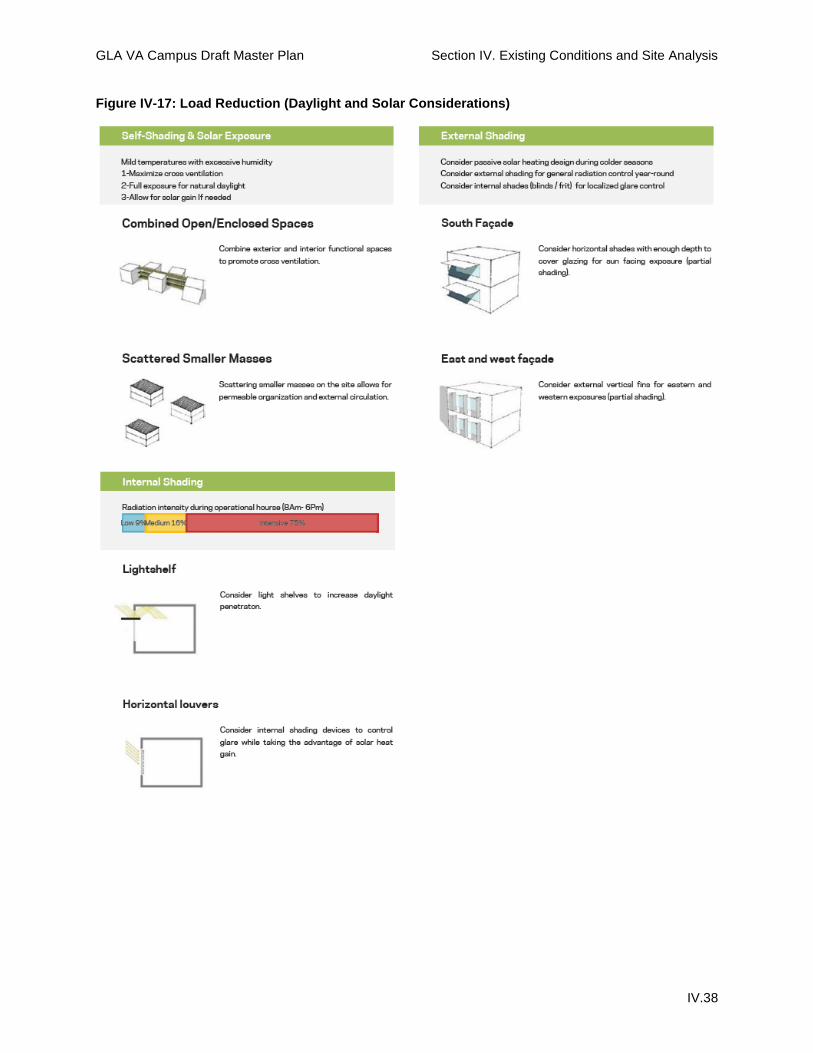
Site-Responsive Strategies for this Climate Zone Overall, this climate zone is very comfortable and requires the least energy of any region in the state to achieve thermal comfort levels. The climatic design priorities that emerge from this analysis include three climate-responsive strategies at the site, building, and landscape scale for the campus.
Site-Responsive Design On a site scale, these climate conditions support a combination of well-landscaped open spaces, enclosed spaces within buildings (central courtyards), and a clustered layout of smaller forms with areas of shared shade over southern and western facades to maximize daytime ventilation. In this mild and temperate climate, the campus can take advantage of full-exposure northern courtyards and vegetation that allows for solar gain near northern facades. External, open-access corridors between buildings and programmatic functions should be oriented to take advantage of prevailing winds. (See Figure IV-17)
Compress campus to minimize outdoor walking distances during the hottest time of the day.
Shaded walkways and canopies over paved surfaces and courtyards will help filter light and heat throughout campus.
Use street orientation and building massing to enhance the natural cooling breezes of the campus.
Connect slender clusters of buildings with archways for maximum solar exposure and cross- ventilation opportunities.
Building Design To minimize the amount of energy required for heating and cooling, the angle of the sun should be considered. With a low to moderate altitude in West Los Angeles for most of the year and the solar radiation on south and west facing walls significantly higher than north and east facing walls, wide awnings should be used to protect openings from solar gain on these sides. Maximizing volume-to-surface ratio optimizes natural light, solar heat gain, and natural ventilation. Wintertime strategies include building insulation, reducing air infiltration, and passive solar heating. Summertime priorities include shade, allowing for natural ventilation and distributing thermal mass.
Landscape Design The benefits of the existing landscape aid in creating a more comfortable environment.
Parks act as heat sinks through transpiration and as wind modifiers that will filter out the dust, reducing pollution.
Xeriscaping should be used to minimize the amount of water drawn for landscape use. Additionally climate appropriate plant material typically requires less maintenance input over their lifetime. This includes plantings in courtyards and roof terraces.
The urban heat island effect of surface parking can be reduced through shade trees and high albedo (reflectivity) paving materials.
GLA VA Campus Draft Master Plan Section IV. Existing Conditions and Site Analysis
IV.38
Figure IV-17: Load Reduction (Daylight and Solar Considerations)

GLA VA Campus Draft Master Plan Section IV. Existing Conditions and Site Analysis
IV.39
D. Opportunities and Constraints The GLA campus exists in a natural and built environment that offers both opportunities and constraints to development. The site’s natural features (topography, plant materials, microclimate) and built features (historic districts, historic buildings and landscapes, existing roads) all influence the design decisions that are intended to enhance human comfort and conserve energy and resources while providing housing and services for Veterans. The Draft Master Plan aims to revitalize the campus by integrating the GLA Campus into its context, breaking down the institutional qualities, and making the campus a part of the larger community. The campus will support recovery while improving connections to the broader community of Veterans and non-Veterans.
Assets Historical Significance The historic setting helps build a character for the North campus.
Preserving the site's historic structures and using them as building blocks for a new community and to establish the appropriate scale of new development, can enhance Veteran pride of ownership, anchor the campus in its prominent place in VA history, and bridge the needs of Veterans and the community at large.
Existing Space/Infrastructure/Buildings Mature landscape providing established stable landscape character.
Topography provides excellent views and a vista from which to view downtown Los Angeles.
A natural topography that can help define neighborhoods.
There are a number of active recreation facilities already built on campus, primed for Veteran use.
The climate conditions permit for year round use of outdoor space.
Campus Circulation Accessible by a number of public transportation routes and proximate to a major downtown.
The climate conditions permit for year round use of bicycle and pedestrian transportation.
Surrounding Neighborhoods and Connectivity Urban proximity to neighboring retail, educational opportunities, and work training provides a
high level of opportunities for residents as they bridge and reintegrate into civilian life as well as make the campus a good permanent home.
Neighboring context is walkable - West Los Angeles is both very walkable and bikeable, with efficient transit access. Most errands can be accomplished on foot.
Challenges Historical Significance Campus has a very low building density, some of which can be attributed to historic
development patterns. Many of the buildings are currently underutilized or even vacant.
Cost of restoration / renovation could be more expensive than new construction.
Existing Space/Infrastructure/Buildings Lack of high-quality and well-designed outdoor spaces

GLA VA Campus Draft Master Plan Section IV. Existing Conditions and Site Analysis
IV.40
Though the campus has an abundance of open space, it has not been designed in a way that is usable as space for relaxation, socializing, or recreation
The combination of functions on campus is ambiguous and more reflective of the medical center’s history and growth patterns than a cohesive set of program relationships
Due to topography and limited access points the campus is isolated from the rest of Los Angeles
Campus Circulation On-campus wayfinding is complicated by a lack of a clear signage system and well-
landscaped gateways, leading to confusion with navigation for visitors and Veterans alike.
Topography of the campus slopes downward from north to south. While the downward slope is generally gentle to the south (only about 200 feet), at the north end of campus the elevation drops considerably and falls off to the east and west; this needs to be considered particularly for pedestrian circulation as well as bicycle and vehicular circulation.
A large average “block” size on campus results in an inefficient transportation system for pedestrians, transit users, and vehicle drivers.
The large amount of paved parking areas contributes to an unpleasant walking experience, a lack of mobility, an emphasis on personal vehicles over other methods of transportation, and isolates parts of campus from one another.
The considerable distance between buildings contributes to perceptions of poor walkability and concern for personal safety, as expressed by many of the staff and residents. The need to drive to multiple destinations and the resulting parking requirements result in an overabundance of parking and isolated buildings that do not support a cohesive neighborhood feeling.
The current scattered and auto-dependent nature of the campus does not support Veteran health, wellness, healing, and recovery.
Contributing site plans, axis and building to open space may come in conflict with a plan for high density building to facilitate non-vehicular transportation and neighborhood activities.
Surrounding Neighborhoods and Connectivity Local and regional vehicular traffic may use Dewey Avenue and Eisenhower Avenue as cut-
throughs to avoid the often heavily trafficked intersection of Wilshire Boulevard and San Vicente Boulevard.
Los Angeles’s “Westside” is known to have a high cost of living.
Opportunities Property Size The campus is a 388 acre property located within a vibrant urban context, which provides an
opportunity to become a regional hub for veteran services.
Existing Connectivity The “West side” has existing networks of public transportation including Santa Monica’s Big
Blue Bus, one of the most inclusive and efficient networks in the region.
The campus has the opportunity to work with the existing Metro systems to establish productive and efficient transportation to and around the campus for campus residents, visitors and staff.

GLA VA Campus Draft Master Plan Section IV. Existing Conditions and Site Analysis
IV.41
Purple Line Extension The Purple Line extension is planned to terminate at the Westwood/VA Hospital Metro
Station.
The Metro line would be a direct route from Downtown Los Angeles’s Union Station to the GLA campus, enhancing campus connectivity to the rest of Los Angeles and beyond.
The master planning should account for and take advantage of the increased accessibility and traffic as well as anticipate neighboring developments due to the line extension.
Greenbelt and Open Spaces Much of the campus is already encompassed by a green belt.
This belt of open space acts as a permeable barrier and symbol of the campus.
The existing open spaces offer enough land for the campus development to be integrated and open spaces to be enhanced in order for Veterans to make the best of the campus open space.
Public Interface Opportunities The stakeholder engagement process demonstrated the desire from Veterans and the local
community to integrate the campus into the surrounding communities.
The surrounding urban context can be an asset in reintegration of veterans into civilian life.
Roads
The existing roads on campus have no clear plan or direction; however, the groundwork for former roads and road systems allow for flexibility in designing a new road system.
Maps, from as recently as 1925, show that the North and South campuses were once connected by a North/South aligned road that ran from the northernmost point to the southernmost point of the campus.
Registered Historic Buildings The two registered historic buildings on the GLA campus can serve as distinguished
symbols, orienting markers and utilized spaces for the campus.
Following restoration, the structures can be used to tell the history of the campus.
South Campus Redevelopment Opportunity Area The South campus has a significant amount of under-utilized land.
It is the center of the medical services for the campus and has potential to become a “one-stop shop” for veteran’s medical needs and a world-class medical facility and treatment center.
Industrial District Redevelopment Opportunity Area The Industrial neighborhood of the property is at a lower grade than the rest of the North
side campus.
This area also has direct access from Constitution Ave off of Sepulveda.
Furthermore, with the development of Purple Line station, its natural separation from the residential areas of campus and its direct access make the area prime for public interface.
Various Infill Opportunity Areas Today, the central area of the campus is the most used and densely built part of the
campus.
This area has a number of historically contributing areas that give the campus character as

GLA VA Campus Draft Master Plan Section IV. Existing Conditions and Site Analysis
IV.42
well as beautiful and useful open spaces.
However, it is possible to densify the area and add coordinated care program and services while maintaining important historical contributions.
Building Restoration Opportunity Area In addition, in the central campus area, there are numerous older, historically contributing
buildings in poor condition.
The area has potential to recall the spirit of the Soldier’s Home through the restoration of these buildings.
Recreation and Independent Housing Opportunity Areas The northern area of the campus is already full of recreation and open space.
It is home to the Japanese Garden, the Golf Course, soccer fields and the Brentwood School recreational facilities.
This area boasts expansive lawns, matured and some historically relevant trees and great views of the ocean, Century City and Downtown Los Angeles.
There is great opportunity to use this open space to serve the therapeutic, recreational and outdoor needs of the veteran community.
The northern boundary of the campus borders a small village center as well as residential neighborhoods.
It is important to consider green space but also to consider the potential expanding need for housing and more diverse types of housing including Veteran supportive housing.
Conclusion Revitalizing the campus through the rehabilitation of existing structures, the addition of new housing, medical services, and amenities could provide an opportunity to use this land to its highest potential in supporting Veterans, leveraging Veteran stewardship, and honoring the legacy of ownership while increasing the opportunities for collaboration between the campus and its neighbors. Achieving these objectives will realize the Veterans community’s compelling shared vision to frame the larger opportunity for Veteran reintegration through coordinated collaborative action.