IV. ALTERNATIVES TO THE PROPOSED PROJECT A
21
IV. ALTERNATIVES TO THE PROPOSED PROJECT Upper Westchester Muslim Society Masjid Islamic Center May, 2012 392 IV. ALTERNATIVES TO THE PROPOSED PROJECT A. No Action Alternative The No Action alternative assumes that the proposed place of worship would not be constructed on the Site, and that the house, garage, and related residential structures on the Property would remain. JMC Figure IV.A, “Site Alternative A: No Action” depicts the existing conditions on the Property as they would remain. The Upper Westchester Muslim Society, a not-for-profit organization, would not be able to provide for its growth or to continue its activities at the Property, outgrown their currently leased space in Thornwood, NY. The UWMS is the owner of the 130 Pines Bridge Road Property, and would need to continue renting the existing home to residential tenants and not be able to use their Property as a center for prayer, Islamic education, and social gatherings, as well as for religious rites and ceremonies. The UWMS would not be able to use the Property to serve the Muslim community, and build bridges with their neighbors of other faiths. The UWMS would not be able to establish a place of worship in this residential neighborhood as other places of worship of other faiths have done within residential neighborhoods in the Town of New Castle. With No Action there would be no benefit of the proposed action in the short term, including the economic benefit from the construction for this use, which includes the creation of jobs and the expenditure of capital for materials for construction. Longer term, there would be no benefit similar to that provided by other places of worship within the Town by providing religious services, religious education, and community outreach programs. Regarding the benefits to the Town, the No Action alternative would continue to provide property and school tax revenue to the Town and school district because the Property would continue to
Transcript of IV. ALTERNATIVES TO THE PROPOSED PROJECT A

IV. ALTERNATIVES TO THE PROPOSED PROJECT
Upper Westchester Muslim Society Masjid Islamic Center
May, 2012
392
IV. ALTERNATIVES TO THE PROPOSED PROJECT
A. No Action Alternative
The No Action alternative assumes that the proposed place of worship would not be constructed on
the Site, and that the house, garage, and related residential structures on the Property would remain.
JMC Figure IV.A, “Site Alternative A: No Action” depicts the existing conditions on the Property
as they would remain.
The Upper Westchester Muslim Society, a not-for-profit organization, would not be able to provide
for its growth or to continue its activities at the Property, outgrown their currently leased space in
Thornwood, NY. The UWMS is the owner of the 130 Pines Bridge Road Property, and would need
to continue renting the existing home to residential tenants and not be able to use their Property as a
center for prayer, Islamic education, and social gatherings, as well as for religious rites and
ceremonies. The UWMS would not be able to use the Property to serve the Muslim community,
and build bridges with their neighbors of other faiths.
The UWMS would not be able to establish a place of worship in this residential neighborhood as
other places of worship of other faiths have done within residential neighborhoods in the Town of
New Castle.
With No Action there would be no benefit of the proposed action in the short term, including the
economic benefit from the construction for this use, which includes the creation of jobs and the
expenditure of capital for materials for construction. Longer term, there would be no benefit
similar to that provided by other places of worship within the Town by providing religious services,
religious education, and community outreach programs.
Regarding the benefits to the Town, the No Action alternative would continue to provide property
and school tax revenue to the Town and school district because the Property would continue to

IV. ALTERNATIVES TO THE PROPOSED PROJECT
Upper Westchester Muslim Society Masjid Islamic Center
May, 2012
393
contain a residential use. There would be no increase in traffic over existing conditions, and no
change in the existing service patterns for police, fire, and emergency services.
B. Alternative Uses Permitted Under Existing Zoning
1. Conventional Single-Family Residential Subdivision Layout
The subject Property is currently comprised of two individual lots (Lots 25 & 27) located in the
R-2A District. Both lots meet the minimum bulk and dimensional requirements of the Town of
New Castle to be developed. However, the overall Property can be re-subdivided into 3
buildable lots while meeting the Town of New Castle bulk and dimensional requirements for
the R-2A District and providing as large a separation distance with the 150-foot wetlands buffer
as possible. JMC Figure IV.B, “Site Alternative B: Residential Subdivision” depicts the layout
of the subdivision. The three proposed subdivided lots would be accessible via a proposed 50
foot wide dead-end right-of-way, located along the Property’s northeastern property line and
intersecting Pines Bridge Road slightly offset to the Pines Bridge Road/Hoag Cross Road
unsignalized intersection. Lot 1 would be 2.13 acres and is located on the western portion of
the Property. A single family residential home would need to be constructed within the 150-
foot wetlands buffer. Lot 2 would be 2.10 acres and would be located on the center of the
Property. A single-family residential home could be constructed on Lot 2, with a minimal
encroachment into the wetlands buffer. Lot 3 would be 3.22 acres and would be located on the
eastern portion of the Property. A single family residential home could be constructed outside
of the 150-foot wetlands buffer; however, a minimal encroachment into the buffer would be
possible as well to place the dwelling closer to the street. All three lots meet the lot frontage,
lot width, and lot depth requirements of the R-2A District.

IV. ALTERNATIVES TO THE PROPOSED PROJECT
Upper Westchester Muslim Society Masjid Islamic Center
May, 2012
394
C. Alternative Site Plan Elements
1. Site Layout That Would Involve No Disturbance Within The Town-Designated 150-Foot
Wetlands Buffer Area
The 150-foot wetland buffer expands across much of the southwestern and southern portions of
the Property, leaving an irregular shaped section to the north and east outside the buffer. This
irregularly shaped portion is a maximum of 200 feet at its widest point. It effectively cuts off
the southeastern portion of the Property from the remainder of the Site. JMC Figure IV.C, “Site
Alternative C: No Wetlands Buffer Disturbance” depicts the limited buildable area on the
Property that is outside of the wetland buffer. A 35-space parking lot is depicted along with a
3,500 square foot (70 feet by 50 feet) place of worship. This facility is approximately 14% of
the size of the Proposed Action building. A building of this size would be unable to
accommodate the current and future educational, recreational, social, and religious needs of
UWMS. As such, this size facility does not meet the needs of the UWMS.
2. Site Layout That Would Eliminate Impervious Surface On Former Tennis Court And
Would Restore That Area To A Functioning Wetland Buffer
The Proposed Action eliminates the existing impervious tennis court, fence, and four light poles
around the perimeter of the tennis court and restores the area as a functioning wetlands buffer.
In addition, the Proposed Action connects the isolated wetlands to the east and west of the large
wetland with the large wetland centrally located on the Property, and restores and enhances the
vegetation. JMC Figure IV.D, “Site Alternative D: Removal of Existing Tennis Court and
Restoration of Wetlands Buffer” depicts the areas that are proposed to be restored as either
wetlands or wetlands buffer.

IV. ALTERNATIVES TO THE PROPOSED PROJECT
Upper Westchester Muslim Society Masjid Islamic Center
May, 2012
395
3. Site Layout That Would Provide For Increased Separation And/Or An Increased Buffer
Between Proposed Parking Facilities And The Neighboring Property Lines.
In achieving an increased separation and buffer between the parking and the neighboring
property to the northeast, this alternative shifts the building, drive aisle, and parking area on the
northern face of the building approximately 40 feet to the southwest. This alternate layout is
depicted on JMC Figure IV-E, “Site Alternative E: Increased Separation Between Parking and
Neighbors.” The proposed site driveway intersection with Pines Bridge Road remains in the
same location as the Proposed Action. This layout contains a total of 170 parking spaces, which
is an increase of 26 parking spaces, to the same as the 170 total spaces studied as part of the
Proposed Action. Three of the parking spaces located along the eastern property line are within
the archeological prehistoric site area. A total of 22 parking spaces are proposed in the front of
the building, which is an increase of six parking spaces in this area as compared to the 16
spaces proposed in the Proposed Action. This alternate layout results in a minimum distance of
57 feet from the northeastern property line to the parking area and 98 feet to the building.
These distances represent large increases over the Proposed Action, in which the layout
provides 20 feet of separation from the northeastern property line to the parking area and 61 feet
from the property line to the building. However, this alternate layout results in a greater
disturbance of the wetlands buffer area, and disturbance to the prehistoric site area. Under this
layout, the wetland located on the southwestern portion of the Property is reduced to 28 feet
from the development, whereas under the layout of the Proposed Action, this distance is 54 feet.
4. Site Layout That Would Provide For Connection Of The Proposed Use To The Sewer
Line In Pines Bridge Road And Use Of The Ossining Sewage Treatment Plant Instead Of
The Proposed On-Site Subsurface Sewage Disposal Area
In establishing a connection the sanitary sewer force main located within Pines Bridge Road,
this alternative eliminates the proposed septic system and 100% expansion area that was to be
located within the parking area located to the northwest of the proposed building. The other
elements of the layout (building location, parking areas, driveway location) remain unchanged

IV. ALTERNATIVES TO THE PROPOSED PROJECT
Upper Westchester Muslim Society Masjid Islamic Center
May, 2012
396
from the layout of the Proposed Action. This alternate layout is depicted on JMC Figure IV-F,
“Site Alternative F: Sanitary Sewer Connection into Pines Bridge Road Force Main.” The
proposed two-inch sanitary sewer will exit the southern face of the building, in the same
location as the Proposed Action. After exiting the building, the sanitary sewer will travel
southwestward around the proposed retaining wall, then travel northwestward towards the force
main within Pines Bridge Road and tie into the force main at a force main manifold manhole.
A total of 286 linear feet of two-inch pressurized PVC pipe is proposed for this purpose.
5. Site Layout That Would Demonstrate Maximum Practicable Application Of Sustainable
Site Design Practices And "Green/Low Impact" Development Techniques And
Components (Beyond Those That May Already Be Included In Proposed Action),
Including But Not Limited To The Highest Possible Reduction Of Impervious Surfaces,
The Use of "Green" Stormwater Practices (e.g. Rain Gardens, Bioretention, Curb Cuts)
The Use Of Infiltration Instead Of Ponds For Stormwater Management, The Use Of
Proposed Design And Construction Methods And/Or Long-Term Operational Practices
Reflecting The Use Of Green Building Technology, And Application Of Measures To
Achieve LEED Certification On A Conceptual Basis And Further Reduction Of The
Proposed Action's Carbon Footprint. Practices And Techniques To Be Reflected In This
Alternative Site Layout Need Not Be In Compliance With Existing Codes And
Regulations, But The Alternative Site Layout Shall Incorporate Elements That Reflect
Consistency With Prevailing Community Character
Sustainability is defined as the consumption of natural resources in a manner that ensures that
the resource will not be permanently depleted or damaged. The goal of sustainable
development is to meet the needs of the present without comprising the ability of future
generations to meet their own needs.
The Project design already incorporates a number of "green/low impact" features, as explained
below. However, there are additional "green/low impact" practices which provide a "greener"
Alterative as requested by the adopted Scoping document in Section 4.0.C.5 (Appendix C).

IV. ALTERNATIVES TO THE PROPOSED PROJECT
Upper Westchester Muslim Society Masjid Islamic Center
May, 2012
397
Additional "green/low impact" practices include the following, which are not proposed for the
Project (Figure IV.G):
A green roof, with plantings on the roof of the facility to utilize rainwater;
Super-insulating the building exterior above and beyond the insulation proposed to
further mitigate building heating and cooling needs;
A geothermal heat pump system which draws its efficiency by utilizing the constant
temperature of the sub-ground, which at this latitude is approximately 55 degrees;
Occupancy sensors to control lighting to reduce energy consumption;
Roof photovoltaic panels for partial electric creation for the building;
Solar thermal panels for heating water;
No-flow toilet fixtures for water savings;
Solar powered parking lot lighting where solar collectors on each lighting fixture
collect energy during the day and stores it in a battery, for use at night;
100% use of pervious pavement throughout all parking lots and driveways for
rainwater infiltration;
Rainwater harvesting for the collection and reuse of rainwater for landscaping and
irrigation;
Reuse of "grey water", which is any water that has been used in the facility, except
water from toilets. Grey water may be used for landscape irrigation.
With regard to the Proposed Action, a number of "green/low impact" practices are proposed.
The Project will: 1) incorporate sustainable site techniques including: deconstruction of existing
buildings for recycled content as well as storm water design, light pollution mitigation, and
minimize building/site development footprint; 2) feature water efficiency through both
selection of landscape material and low flow plumbing fixtures; 3) include energy efficient
mechanical and electrical systems; 4) select materials that are produced regionally, contain high
recycled material content, and no VOC’s; and 5) utilize natural light and natural ventilation
enhanced by high ceiling spaces, and orientation to maximize comfort while minimizing fossil
fuel energy needs.

IV. ALTERNATIVES TO THE PROPOSED PROJECT
Upper Westchester Muslim Society Masjid Islamic Center
May, 2012
398
Site Design is the first step to a sustainable project. As stated, UWMS intends to deconstruct the
existing buildings (instead of demolition), so that materials that can be recycled are separated
from the general disposed material. This will generate less waste that needs to be deposited into
land fill. The proposed building has been designed to take advantage of the Site contours and be
‘compact’ with minimal space for circulation and most rooms designed to have multiple
functions. The Greeting Hall and Social Hall are primary examples of careful design that
maximizes available space. The Greeting Hall functions as 1) the reception area before and after
services, 2) display and circulation hallway to the educational area, and 3) expanded worship
area during holy day services. The Social Hall functions as 1) a dining hall for potluck dinners
and receptions, 2) a gymnasium for athletic activities, and 3) expanded worship area during the
holy days. In lieu of expanding the building footprint, the design also utilizes the site grade and
orientation exposure to create a lower level for educational purposes (out of a basement) which
gains light and egress due to the sloping site.
The landscape and plumbing design is intended to limit water consumption on campus.
Landscape material selection will be indigenous. Once established over the first year, will
require no or minimal irrigation. The selection of water efficient fixtures will reduce internal
consumption by up to 30% of water usage by incorporating low flow water toilet/urinal fixtures
and sensor activated sinks.
Reduction of energy usage is critical for a sustainable building. UWMS will take a holistic
approach to building and system design. This includes the building ‘envelope’ or exterior wall
construction and the heating / cooling and lighting/power systems. The base plan is to use an
augmented building enclosure by incorporating a thicker mass of insulation than is Code
required, as well as utilizing low-E insulated glazing to reduce heat gain and maximize R-value.
Highly efficient mechanical systems, which utilize the returning hot and cool air to temper the
new supply (heat recovery) and programmable intelligent mechanical systems, are planned.
The use of natural daylight has been focal to the conceptual design. ‘Daylighting’ takes into
account sun angles, orientation, and proposed hours of operation to maximize the sun’s energy
and minimize the need for artificial lighting. Clerestory fenestration and skylights will draw in

IV. ALTERNATIVES TO THE PROPOSED PROJECT
Upper Westchester Muslim Society Masjid Islamic Center
May, 2012
399
natural light further into the building than perimeter windows alone. The natural light will be
augmented with energy efficient lighting fixtures.
The building will also be designed with regional building materials wherever possible, a high
level of recyclable building materials and no volatile organic compounds (VOC’s). Each
building product that is specified will be reviewed within these criteria. Fortunately, the
construction industry has modified many of their practices in the past decade, so that not only
are there many more products that have ‘green’ attributes, but they are also cost effective.
6. Alternative Traffic Impact Analysis
Complete And Describe The Results Of A "Sensitivity Analysis" That Reflects A Different
Distribution Of Site-Generated Traffic For Use Of The Proposed Facility On Weekday
And Weekend Peak Hours And On High Holy Days. As An Alternative To The Trip
Distribution Examined Under The Proposed Action, The Alternative Analysis Shall
Assign The Anticipated Number Of Families And Students Expected To Use The Facility
By 2018 According To The Following Distribution Patterns:

IV. ALTERNATIVES TO THE PROPOSED PROJECT
Upper Westchester Muslim Society Masjid Islamic Center
May, 2012
400
Roadway Segment Used Percent Of Total
Taconic Parkway Northbound To Pines Bridge
Road Westbound 15
Taconic Parkway Southbound To NY Route
134 Westbound 11
Pines Bridge Road Eastbound 30
Pines Bridge Road Eastbound (East Of
Parkway) 15
NY Route 134 Eastbound From NY Route 9A 29
Total 100
The "Sensitivity Analysis" Shall Be Modeled After Subsections 3.7.B.1.D Through
3.7.B.1.I Of The Scope (Appendix C) Inclusive And Shall Also Include Capacity Analyses
For The Following Intersections In Addition To Those Identified Under Subsection
3.7.A.1.B Of The Scope:
Croton Dam Road (NY Route 134 At Taconic State Parkway Ramps (Four
Intersections)
Manual turning movement counts were conducted on Friday, February 8, 2008, and
Saturday, February 9, 2008, which are the same dates as the counts performed for the
primary analysis. All counts were conducted from 11:00 AM to 6:00 PM. Schools were in
session and there were no holidays during the count dates. Fridays and Saturdays were
chosen as count dates because they are typically the highest traffic volume days of the week,
and Fridays and Saturdays have the highest anticipated site-generated volumes for the
facility.
Based on a manual traffic volume survey that was performed at the Pines Bridge Road/Hoag
Cross Road intersection on Monday 6/7/2010 from 9:00-10:00 AM, the Monday and other
weekday volumes along Pines Bridge Road resulting from the ATR counts were found to be
generally similar to and/or lower than the volumes occurring between 11:00 am and 2:00
pm. The manual count conducted on 6/7/2010 is consistent with ATR counts. The DEIS
superimposed the holiday site generated peak hour volumes on the volumes counted at the

IV. ALTERNATIVES TO THE PROPOSED PROJECT
Upper Westchester Muslim Society Masjid Islamic Center
May, 2012
401
area intersections on Friday at 1:15-2:15 pm. Since the Monday morning volumes are
consistent with the Friday afternoon volumes, no additional counts are believed to be
necessary for determining the holiday traffic impact on the area intersections. The Tables,
ATR counts and the manual turning movement count data are included in Volume III
Appendix L.
a. Vehicle Trip Distribution
The Sensitivity Analysis Site Generated Distributions reflect additional trips utilizing
local roads such as Hoag Cross Road and Pines Bridge Road to access the Site instead of
utilizing the arterial Taconic State Parkway, which was the anticipated travel route of the
majority of site generated trips as outlined in Section 3.7.B.1.d above. The Sensitivity
Analysis Distributions are depicted on Figure 11A in Appendix L. The traffic counts for
the additional intersections that are included in the Sensitivity Analysis were conducted on
Friday, February 1, 2008 and Saturday, February 2, 2008.
The Sensitivity Analysis Site Generated Distributions are unrealistic given the roadway
network in the vicinity of the Site. Such a large percentage of vehicles travelling to the
Site from NY 9A would likely not continue eastward on Croton Dam Road (NY 134) up
to subsequently travel southwestward on McDonald Road/Hoag Cross Road to access
Pines Bridge Road. Vehicles could also use Grace Lane, which connects Croton Dam
Road (NY 134) to Pines Bridge Road less than one mile to the south of the Site. Grace
Lane provides a more direct route to the Site from Croton Dam Road (NY 134).
Therefore, the Sensitivity Analysis Distributions are considered conservative for
intersection operations at the Hoag Cross Road/Pines Bridge Road intersection.
b. Build Traffic Volume Projections
Multiplying the overall Site Generated Volumes by the Sensitivity Analysis Site
Generated Distributions results in the Sensitivity Analysis Site Generated Volumes for
each intersection. The Sensitivity Analysis Site Generated Volumes are depicted on

IV. ALTERNATIVES TO THE PROPOSED PROJECT
Upper Westchester Muslim Society Masjid Islamic Center
May, 2012
402
Figures 12A, 13A, and 14A in Appendix L. Addition of the Sensitivity Analysis Site
Generated Volumes with the 2018 No-Build Volumes results in the 2018 Sensitivity
Analysis Build Volumes. The 2018 Sensitivity Analysis Build Volumes are depicted on
Figures 15A, 16A, 17A, and 18A in Appendix L.
In addition to the intersections included in the primary traffic analysis above, the
Sensitivity Analysis includes the Croton Dam Road (NY 134) and Taconic State Parkway
Ramps as additional intersections to evaluate operations as well. These additional
intersections have minimal site generated traffic as compared to the originally studied
intersections.
c. Capacity Analyses
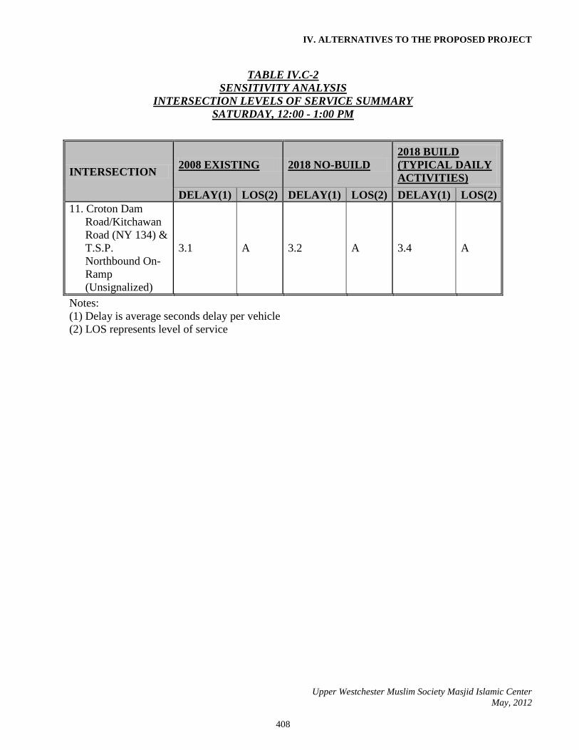
The 2018 Sensitivity Analysis Build intersection operations are summarized in Table 4A,
“Sensitivity Analysis Intersection Operations – Friday, 1:15-2:15 PM,” Table 5A,
“Sensitivity Analysis Intersection Operations – Saturday, 12:00-1:00 PM,” and Table 6A,
“Sensitivity Intersection Operations – Saturday, 1:15-2:15 PM,” located in Appendix L.
The Capacity Analyses are provided in Appendix L.
The Capacity Analyses for the three hours (Friday, 1:15-2:15 PM; Saturday, 12:00-1:00
PM; and Saturday, 1:15-2:15 PM) indicate that the intersections under consideration
operate with excess capacity and excellent Levels of Service during the Sensitivity
Analysis Build conditions. Similar to the primary traffic analysis above, delays are
expected to be minimal in all directions at each intersection.
d. Findings & Discussion
The Capacity Analyses for all three hours under consideration indicate that there is excess
capacity and there are minimal delays for all intersections during the 2008 Existing, 2018
No-Build, and 2018 Sensitivity Analysis Build conditions. The overall intersection delays

IV. ALTERNATIVES TO THE PROPOSED PROJECT
Upper Westchester Muslim Society Masjid Islamic Center
May, 2012
403
and Levels of Service for the 2008 Existing, 2018 No-Build, and 2018 Sensitivity
Analysis Build conditions are summarized in the Tables below:
TABLE IV.C-1
SENSITIVITY ANALYSIS
INTERSECTION LEVELS OF SERVICE SUMMARY
FRIDAY, 1:15 - 2:15 PM
INTERSECTION 2008 EXISTING 2018 NO-BUILD
2018 BUILD
(TYPICAL DAILY
ACTIVITIES)
2018 BUILD
(HOLIDAY
ACTIVITIES)
DELAY(1) LOS(2) DELAY(1) LOS(2) DELAY(1) LOS(2) DELAY(1) LOS(2)
1. Pines Bridge
Road &
Proposed Site
Driveway
(Unsignalized)
N/A N/A 2.8 A 6.1 A
2. Pines Bridge
Road & Hoag
Cross Road
(Unsignalized)
0.7 A 0.7 A 1.6 A 2.8 A
3. Pines Bridge
Road & T.S.P.
Southbound
Ramp
(Unsignalized)
1.8 A 1.9 A 1.7 A 1.3 A
4. Pines Bridge
Road & T.S.P.
Northbound
Ramp
(Unsignalized)
2.5 A 2.5 A 2.4 A 2.1 A
5. Pines Bridge
Road & Shingle
House Road
(Unsignalized)
3.4 A 3.5 A 3.3 A 3.0 A
6. Croton Dam
Rd/Kitchawan
Rd (NY 134) &
McDonald Rd
(Unsignalized)
0.6 A 0.7 A 1.3 A 2.7 A

IV. ALTERNATIVES TO THE PROPOSED PROJECT
Upper Westchester Muslim Society Masjid Islamic Center
May, 2012
404
TABLE IV.C-1
SENSITIVITY ANALYSIS
INTERSECTION LEVELS OF SERVICE SUMMARY
FRIDAY, 1:15 - 2:15 PM
INTERSECTION 2008 EXISTING 2018 NO-BUILD
2018 BUILD
(TYPICAL DAILY
ACTIVITIES)
2018 BUILD
(HOLIDAY
ACTIVITIES)
DELAY(1) LOS(2) DELAY(1) LOS(2) DELAY(1) LOS(2) DELAY(1) LOS(2)
7. Croton Dam
Road/Kitchawa
n Road (NY
134) &
Illington
Road/Grant
Lane/T.S.P.
Southbound
On-Ramp
(Unsignalized)
1.0 A 1.1 A 1.1 A 1.1 A
8. Croton Dam
Road/
Kitchawan
Road (NY 134)
& T.S.P.
Southbound
Off-Ramp
(Unsignalized)
1.9 A 1.9 A 1.9 A 1.8 A
9. Croton Dam
Road/
Kitchawan
Road (NY 134)
& T.S.P.
Southbound
Off-Ramp
(Unsignalized)
1.2 A 1.3 A 1.3 A 1.2 A
10. Croton Dam
Road/
Kitchawan
Road (NY 134)
& T.S.P.
Northbound
Off-Ramp
(Unsignalized)
1.5 A 1.6 A 1.6 A 1.5 A

IV. ALTERNATIVES TO THE PROPOSED PROJECT
Upper Westchester Muslim Society Masjid Islamic Center
May, 2012
405
TABLE IV.C-1
SENSITIVITY ANALYSIS
INTERSECTION LEVELS OF SERVICE SUMMARY
FRIDAY, 1:15 - 2:15 PM
INTERSECTION 2008 EXISTING 2018 NO-BUILD
2018 BUILD
(TYPICAL DAILY
ACTIVITIES)
2018 BUILD
(HOLIDAY
ACTIVITIES)
DELAY(1) LOS(2) DELAY(1) LOS(2) DELAY(1) LOS(2) DELAY(1) LOS(2)
11. Croton Dam
Road/Kitchawan
Road (NY 134)
& T.S.P.
Northbound On-
Ramp
(Unsignalized)
1.7 A 1.8 A 1.9 A 2.1 A
Notes:
(1) Delay is average seconds delay per vehicle
(2) LOS represents level of service

IV. ALTERNATIVES TO THE PROPOSED PROJECT
Upper Westchester Muslim Society Masjid Islamic Center
May, 2012
406
TABLE IV.C-2
SENSITIVITY ANALYSIS
INTERSECTION LEVELS OF SERVICE SUMMARY
SATURDAY, 12:00 - 1:00 PM
INTERSECTION 2008 EXISTING 2018 NO-BUILD
2018 BUILD
(TYPICAL DAILY
ACTIVITIES)
DELAY(1) LOS(2) DELAY(1) LOS(2) DELAY(1) LOS(2)
1. Pines Bridge Road
& Proposed Site
Driveway
(Unsignalized)
N/A N/A 5.3 A
2. Pines Bridge Road
& Hoag Cross
Road
(Unsignalized)
0.9 A 3.0 A 3.9 A
3. Pines Bridge Road
& T.S.P.
Southbound Ramp
(Unsignalized)
1.4 A 0.7 A 0.6 A
4. Pines Bridge
Road & T.S.P.
Northbound Ramp
(Unsignalized)
2.9 A 3.1 A 3.1 A
5. Pines Bridge Road
& Shingle House
Road
(Unsignalized)
4.0 A 4.4 A 3.9 A
6. Croton Dam
Rd/Kitchawan Rd
(NY 134) &
McDonald Rd
(Unsignalized)
0.4 A 0.4 A 1.6 A

IV. ALTERNATIVES TO THE PROPOSED PROJECT
Upper Westchester Muslim Society Masjid Islamic Center
May, 2012
407
TABLE IV.C-2
SENSITIVITY ANALYSIS
INTERSECTION LEVELS OF SERVICE SUMMARY
SATURDAY, 12:00 - 1:00 PM
INTERSECTION 2008 EXISTING 2018 NO-BUILD
2018 BUILD
(TYPICAL DAILY
ACTIVITIES)
DELAY(1) LOS(2) DELAY(1) LOS(2) DELAY(1) LOS(2)
7. Croton Dam
Road/Kitchawan
Road (NY 134) &
Illington
Road/Grant
Lane/T.S.P.
Southbound On-
Ramp
(Unsignalized)
1.0 A 1.1 A 1.1 A
8. Croton Dam
Road/ Kitchawan
Road (NY 134) &
T.S.P.
Southbound Off-
Ramp
(Unsignalized)
2.2 A 2.3 A 2.3 A
9. Croton Dam
Road/ Kitchawan
Road (NY 134) &
T.S.P.
Southbound Off-
Ramp
(Unsignalized)
1.2 A 1.2 A 1.2 A
10. Croton Dam
Road/ Kitchawan
Road (NY 134) &
T.S.P.
Northbound Off-
Ramp
(Unsignalized)
1.3 A 1.4 A 1.4 A
IV. ALTERNATIVES TO THE PROPOSED PROJECT
Upper Westchester Muslim Society Masjid Islamic Center
May, 2012
408
TABLE IV.C-2
SENSITIVITY ANALYSIS
INTERSECTION LEVELS OF SERVICE SUMMARY
SATURDAY, 12:00 - 1:00 PM
INTERSECTION 2008 EXISTING 2018 NO-BUILD
2018 BUILD
(TYPICAL DAILY
ACTIVITIES)
DELAY(1) LOS(2) DELAY(1) LOS(2) DELAY(1) LOS(2)
11. Croton Dam
Road/Kitchawan
Road (NY 134) &
T.S.P.
Northbound On-
Ramp
(Unsignalized)
3.1 A 3.2 A 3.4 A
Notes:
(1) Delay is average seconds delay per vehicle
(2) LOS represents level of service

IV. ALTERNATIVES TO THE PROPOSED PROJECT
Upper Westchester Muslim Society Masjid Islamic Center
May, 2012
409
TABLE IV.C-3
SENSITIVITY ANALYSIS
INTERSECTION LEVELS OF SERVICE SUMMARY
SATURDAY, 1:15 - 2:15 PM
INTERSECTION 2008 EXISTING 2018 NO-BUILD
2018 BUILD
(HOLIDAY
ACTIVITIES)
DELAY(1) LOS(2) DELAY(1) LOS(2) DELAY(1) LOS(2)
1. Pines Bridge Road
& Proposed Site
Driveway
(Unsignalized)
N/A N/A 6.8 A
2. Pines Bridge Road
& Hoag Cross
Road
(Unsignalized)
1.0 A 3.0 A 4.2 A
3. Pines Bridge Road
& T.S.P.
Southbound Ramp
(Unsignalized)
1.4 A 0.7 A 0.6 A
4. Pines Bridge Road
& T.S.P.
Northbound Ramp
(Unsignalized)
3.2 A 3.3 A 2.9 A
5. Pines Bridge Road
& Shingle House
Road
(Unsignalized)
3.1 A 3.8 A 3.2 A
6. Croton Dam
Rd/Kitchawan Rd
(NY 134) &
McDonald Rd
(Unsignalized)
0.6 A 0.6 A 2.7 A

IV. ALTERNATIVES TO THE PROPOSED PROJECT
Upper Westchester Muslim Society Masjid Islamic Center
May, 2012
410
TABLE IV.C-3
SENSITIVITY ANALYSIS
INTERSECTION LEVELS OF SERVICE SUMMARY
SATURDAY, 1:15 - 2:15 PM
INTERSECTION 2008 EXISTING 2018 NO-BUILD
2018 BUILD
(HOLIDAY
ACTIVITIES)
DELAY(1) LOS(2) DELAY(1) LOS(2) DELAY(1) LOS(2)
7. Croton Dam
Road/Kitchawan
Road (NY 134) &
Illington
Road/Grant
Lane/T.S.P.Southbo
und On-Ramp
(Unsignalized)
1.4 A 1.6 A 1.5 A
8. Croton Dam Road/
Kitchawan Road
(NY 134) & T.S.P.
Southbound Off-
Ramp
(Unsignalized)
2.3 A 2.4 A 2.3 A
9. Croton Dam Road/
Kitchawan Road
(NY 134) & T.S.P.
Southbound Off-
Ramp
(Unsignalized)
0.9 A 1.0 A 0.9 A
10. Croton Dam Road/
Kitchawan Road
(NY 134) & T.S.P.
Northbound Off-
Ramp
(Unsignalized)
1.3 A 1.5 A 1.5 A

IV. ALTERNATIVES TO THE PROPOSED PROJECT
Upper Westchester Muslim Society Masjid Islamic Center
May, 2012
411
TABLE IV.C-3
SENSITIVITY ANALYSIS
INTERSECTION LEVELS OF SERVICE SUMMARY
SATURDAY, 1:15 - 2:15 PM
INTERSECTION 2008 EXISTING 2018 NO-BUILD
2018 BUILD
(HOLIDAY
ACTIVITIES)
DELAY(1) LOS(2) DELAY(1) LOS(2) DELAY(1) LOS(2)
11. Croton Dam
Road/Kitchawan
Road (NY 134) &
T.S.P.
Northbound On-
Ramp
(Unsignalized)
2.7 A 2.7 A 3.1 A
Notes:
(1) Delay is average seconds delay per vehicle
(2) LOS represents level of service
The proposed development of the Property is expected to have marginal, if any, increases
on delays for all approaches as compared to the 2018 No-Build conditions and even the
2008 Existing conditions. The roadways have relatively low existing volumes which
contribute to their ability to handle both the general growth and the site generated traffic.
e. Analysis
None of the traffic impacts of the Sensitivity Analysis are considered significant based
upon the criteria outlined the Scope. No Levels of Service deteriorate from A, B, C to D,
E, or F. In fact, the largest deterioration is from an A to a B. No volume to capacity (v/c)
ratios approach 1.0 in the No-Build or Build scenario, as the highest ratio during the Build
condition for any of the hours under consideration is 0.25 (for the proposed Site Driveway
during the 2018 Build (Holiday) Friday hour). No intersections under consideration have
dedicated turning lanes, as they are all unsignalized intersections with low volumes of
traffic. Therefore, the queue length requirements do not apply.

IV. ALTERNATIVES TO THE PROPOSED PROJECT
Upper Westchester Muslim Society Masjid Islamic Center
May, 2012
412
f. Impacts On Pedestrian And Bicycle Circulation In The Vicinity Of The Site
As mentioned previously, there was minimal pedestrian and bicycle activity observed in
the vicinity of the Site. Therefore, it is expected that the proposed facility’s traffic under
the Sensitivity Analysis would have minimal impact on pedestrian and bicycle circulation
as there is minimal pedestrian and bicycle activity under existing conditions.

ALTERNATIVES TO THE PROPOSED PROJECT
Table IV.1
Comparison of UWMS Alternatives
PROPOSED
ACTION
ALTERNATIVES
Alternative "B"
Uses Permitted
Under Existing
Zoning
(Residential
Subdivision)
Alternative "C"
No Wetland
Buffer Impact
Alternative "D"
Removal of Tennis
Court Impervious
Surface
Alternative "E"
Increased Neighbor
Buffer
Alternative "F"
Sewer Connection
Alternative "G"
"Green/Low Impact"
Parcel Size (acres) 8.33 Acres 8.33 Acres 8.33 Acres 8.33 Acres 8.33 Acres 8.33 Acres 8.33 Acres
Project Type Place of Worship Residential Place of
Worship
Place of Worship Place of Worship Place of Worship Place of Worship
No. of Buildings 1 3 1 1 1 1 1
Total Square Footage
Of Buildings 24,690
4,500/Each
(minimum) 3,500 24,690 24,690 24,690 24,690
# of Dwelling Units
Type of Dwelling Units
# of Bedrooms Per Unit
N/A
3
Single-Family
Detached
5
N/A N/A N/A N/A N/A
Steep Slopes (≥15%)
Total on Site
% of Site
0.63 acres
8%
0.63 acres
8%
0.63 acres
8%
0.63 acres
8%
0.63 acres
8%
0.63 acres
8%
0.63 acres
8%
Total Disturbed
% Disturbed
0.17 acres
27%
0.16 acres
25%
0.03 acres
5%
0.18 acres
29%
0.17 acres
27%
0.17 acres
27%
0.17 acres
27%
Wetlands, Watercourses
And Waterbodies
Total on Site
% of Site
0.57 acres
6.90%
0.57 acres
6.90%
0.57 acres
6.90%
0.57 acres
6.90%
0.57 acres
6.90%
0.57 acres
6.90%
0.57 acres
6.90%
Total Disturbed
% Disturbed
0 acres
0%
0 acres
0%
0 acres
0%
0 acres
0%
0 acres
0%
0 acres
0%
0 acres
0%
150-Foot Wetland Buffer
Total on Site
% of Site
4.68 acres
56%
4.68 acres
56%
4.68 acres
56%
4.68 acres
56%
4.68 acres
56%
4.68 acres
56%
4.68 acres
56%
Total Disturbed
% Disturbed
2.06
44%
1.48
32%
0
0%
2.06
44%
2.13
46%
2.06
44%
2.06
44%
Proposed Impervious Surfaces (%) 12.7%(1)
6.2% 5.5% 12.7%(1)
12.7%(1)
12.7%(1)
5.6%(1)

Table IV.1
Comparison of UWMS Alternatives
PROPOSED
ACTION
ALTERNATIVES
Alternative "B"
Uses Permitted
Under Existing
Zoning
(Residential
Subdivision)
Alternative "C"
No Wetland
Buffer Impact
Alternative "D"
Removal of Tennis
Court Impervious
Surface
Alternative "E"
Increased Neighbor
Buffer
Alternative "F"
Sewer Connection
Alternative "G"
"Green/Low Impact"
Peak Hour Vehicular Trips Including Credit for
Existing Trips
AM
N/A
2
N/A
N/A
N/A
N/A
N/A
PM (See Note 3)
64
4
9
64
64
64
64
SAT
174
3
25
174
174
174
174
Holiday 216 N/A 31 216 216 216 216
Land Use, Planning and Zoning – Uses
Permitted Use
Place of Worship
1-Family
Detached
Dwellings (3)
Place of Worship
Place of Worship
Place of Worship
Place of Worship
Place of Worship
Subsurface Sewage Treatment System
Provided; maximum
1,580 gallons per day
discharge; 7,854± s.f. of
wetland buffer
disturbance
3 Separate
Systems,
Combined 1,320
gallons per day
discharge; no
wetland buffer
disturbance
Provided;
maximum 1,580
gallons per day
discharge; no
wetland buffer
disturbance
Provided;
maximum 1,580
gallons per day
discharge; 7,854±
s.f. of wetland
buffer disturbance
Provided;
maximum 1,580
gallons per day
discharge; 7,854±
s.f. of wetland
buffer disturbance
Not Needed; 287
linear feet by 10
feet wide
(2,870± s.f.) of
construction
disturbance with
permanent
installation of
sanitary piping
Provided; maximum
1,580 gallons per day
discharge; 7,854± s.f.
of wetland buffer
disturbance
Site Disturbance (Acres)
-Total
-Vegetation
-# of Trees Removed
3.6
0.9
192
2.8
1.3
156
0.9
0.9
10
3.6
0.9
192
4.0
2.0
229
3.6
0.9
192
3.6
0.9
192
Water Usage (gpd)
1,580 (See Section
III.F.2.b.i))
1,320 1,580 1,580 1,580 1,580 Less than 1,580
Air Quality and Noise Impact
Imperceptible(17) Less additional
traffic noise than
Proposed Action;
no air quality
impact
(17)
Imperceptible
(17)
Imperceptible
(17)
37 feet of increased
separation from
northerly property
line helps reduce
minor noise from
student outside
breaks
(17)
Imperceptible
(17)
Imperceptible
Number of Children Entering Public School System
0 5-6 0
0 0 0 0

Table IV.1
Comparison of UWMS Alternatives
PROPOSED
ACTION
ALTERNATIVES
Alternative "B"
Uses Permitted
Under Existing
Zoning
(Residential
Subdivision)
Alternative "C"
No Wetland
Buffer Impact
Alternative "D"
Removal of Tennis
Court Impervious
Surface
Alternative "E"
Increased Neighbor
Buffer
Alternative "F"
Sewer Connection
Alternative "G"
"Green/Low Impact"
Impact on Town Recreational Facilities
None Use by 3
additional
families
None
None
None
None
None
Fiscal Impacts
Tax-Exempt but
minimal use of Town
Services
Pay Property
Taxes for 3
single-family
homes
Tax-Exempt but
minimal use of
Town Services
Tax-Exempt but
minimal use of
Town Services
Tax-Exempt but
minimal use of
Town Services
Tax-Exempt but
minimal use of
Town Services
Tax-Exempt but
minimal use of Town
Services
Visual Impacts
Screened view of
building from roadway
(222 feet distant) and
northerly property line
(61 feet distant)(see
Volume I, Section
III.M.2.b, and Figures
III.M-3, a, b, c)
Smaller
residential
structure but 137
feet closer to
roadway than
Proposed Action;
125 feet to
northerly property
line
Smaller
building at 226
feet from
roadway and 98
feet from
northerly
property line
reduces visual
impact
Screened view of
building from
roadway (222 feet
distant) and
northerly property
line (61 feet
distant), same as
Proposed Action
Screened view of
building from
roadway (222 feet
distant) and
increased northerly
neighbor buffer
with northerly
property line 98
feet distant, helps
reduce visual
impacts
Screened view of
building from
roadway (222
feet distant) and
northerly
property line (61
feet distant),
same as
Proposed Action
Screened view of
building from
roadway (222 feet
distant) and northerly
property line (61 feet
distant), same as
Proposed Action
Construction Impacts
Temporary noise and
land disturbance from
construction (see
Volume I, Section III.N
for discussion)
Construction time
extended with
phasing of
roadway and
home
construction;
temporary noise
and land
disturbance
impacts
Smaller
building and
parking area
reduces extent
and time of
construction;
temporary noise
and land
disturbance
impacts
Temporary noise
and land
disturbance from
construction, same
as Proposed
Action
Temporary noise
and land
disturbance from
construction; 0.4
additional acres of
site disturbance
than Proposed
Action
Temporary noise
and land
disturbance from
construction
(insert sf. for
trench for pipe),
same as
Proposed Action
Temporary noise and
land disturbance from
construction, same as
Proposed Action
Notes:
1. Impervious Surface Percentages do not include areas of proposed pervious pavement. For Proposed Action and Alternatives D, E, and F, pervious pavement accounts for a total of 0.94 acres (11.3% of total property
area). For Alternative G, pervious pavement area accounts for a total of 1.48 acres (17.8% of total property area).
2. The Peak PM Hour for the Place of Worship use is 1:15-2:15 PM; the Peak PM Hour for a residential subdivision would be between 4:00 and 6:00 PM.
3. Other principal permitted uses within the R-2A zoning district are: 1. Public School. 2. Private School.*

3. Public library, museum or art gallery not operated for profit.* 4. Municipal use of the Town of New Castle. 5. Monastery or private club, not operated for profit.* 6. Plant nursery.* 7. Day nursery or day play school operated and conducted in accordance with recognized standards and practices in the field of child training or education.* 8. College, seminary or university having a curriculum approved by the State Board of Regents.* 9. Summer theater for presentation of plays between June 1 and October 1.* 10. Gas and electric power transmission lines and transformers and switching stations.* 11. Nursing homes.* 12, For religious (other than places of worship and monasteries as permitted above), charitable or other similar nonprofit uses, referred
to as “institutional uses.”* 13. The farming of crops and/or the raising of poultry, livestock, chinchillas or rabbits, subject to the issuance of a special use permit by the Town Board.* 14. Utility structures for the transmission, storage and/or treatment of water and sewage.** 15. Structurally mounted wireless telecommunication services facility (minor).** 16. Structurally mounted wireless telecommunication services facility (major), monopole and tower, subject to issuance of a special permit by the Planning
Board. 17. As described in Volume I, Section III.H.2.a, NYSDOT guidelines use hierarchical criteria to determine whether an air quality analysis is required for a proposed development. For the subject project and all
alternatives, applying these criteria has determined that no further air quality analysis is required. As described in Volume I, Section III.H.2.b, noise increases resulting from increased traffic will be imperceptible to most observers. Minor noise generated by short outside breaks from religious school students will be intermittent in nature.
* Requires Special Permit Approval from the Zoning Board of Appeals. ** Requires Site Development Plan Approval from the Planning Board.
f:\2005\5043\comparison of uwms alternatives Table IV.1.docx

FIG
UR
E:
DA
TE:
03/1
1/20
11
130
PIN
ES
BR
IDG
E R
OA
D
JMC
PR
OJE
CT:
504
3
TOW
N O
F N
EW
CA
STL
E, N
EW
YO
RK
SC
ALE
: 1" =
80'
UW
MS
MA
SJI
D &
IS
LAM
IC C
EN
TE
R
SIT
E A
LTE
RN
AT
IVE
AN
O A
CT
ION
IV.A

FIG
UR
E:
DA
TE:
03/1
1/20
11
130
PIN
ES
BR
IDG
E R
OA
D
JMC
PR
OJE
CT:
504
3
TOW
N O
F N
EW
CA
STL
E, N
EW
YO
RK
SC
ALE
: 1" =
80'
UW
MS
MA
SJI
D &
IS
LAM
IC C
EN
TE
R
SIT
E A
LTE
RN
AT
IVE
BR
ES
IDE
NT
IAL
SU
BD
IVIS
ION
IV.B

FIG
UR
E:
DA
TE:
130
PIN
ES
BR
IDG
E R
OA
D
JMC
PR
OJE
CT:
504
3
TOW
N O
F N
EW
CA
STL
E, N
EW
YO
RK
SC
ALE
: 1" =
80'
UW
MS
MA
SJI
D &
IS
LAM
IC C
EN
TE
R
SIT
E A
LTE
RN
AT
IVE
C
IV.C
NO
WE
TLA
ND
BU
FFE
R D
IST
UR
BA
NC
E

MENA5
196 sfJANA5a15 sf
ABLUTION
A6b135 sf
DAILY PRAYER
A6a
753 sf
CEILING HEIGHT: 9'-0"
VESTIBULE
A6
231 sf
MASJID
(MEN'S PRAYER HALL)
A3
2,836 sf
CEILING HEIGHT: 25'-6" CENTER
19'-0" SIDES
SOCIAL HALL /
ACTIVITY HALL
A4
4,510 SF
CEILING HEIGHT: 25'-6" CENTER, 19'-0" S
IDES
BASKETBALL COURT 50x68
OFFICE
A9194 sf
WARMING KITCHEN
A11
402 sf
STORAGE
A4c234 sf
MEETING ROOM
A4b
472 sf
WOMEN
A7196 sf
JANA7a15 sf
ABLUTION
A8b135 sf
QUIET ROOM
A8a
753 sf
CEILING HEIGHT: 9'-0"
STORA3b46 sf
GREETING HALL
A2
1,546 sf
ENTRY HALL
A1230 sf
STAIRB1177 sf
(WOMEN'S AREA)
VESTIBULE
A8231 sf
BABY SITTING
A4a234 sf
DINING
A10
208 sf CORRIDOR
CEILING HEIGHT: 9'-0"
FIG
UR
E:
DA
TE:
03/1
1/20
11
130
PIN
ES
BR
IDG
E R
OA
D
JMC
PR
OJE
CT:
504
3
TOW
N O
F N
EW
CA
STL
E, N
EW
YO
RK
SC
ALE
: 1" =
80'
UW
MS
MA
SJI
D &
IS
LAM
IC C
EN
TE
R
SIT
E A
LTE
RN
AT
IVE
DR
EM
OV
AL
OF
EX
IST
ING
TE
NN
IS C
OU
RT
AN
D R
ES
TO
RA
TIO
N O
F W
ET
LAN
DS
BU
FFE
R
IV.D

MENA5196 sfJAN
A5a15 sf
ABLUTION
A6b
135 sf
DAILY PRAYER
A6a753 sf
CEILING HEIGHT: 9'-0"
VESTIBULE
A6231 sf
MASJID
(MEN'S PRAYER HALL)
A3
2,836 sf
CEILING HEIGHT: 25'-6" CENTER
19'-0" SIDES
SOCIAL HALL /
ACTIVITY HALL
A4
4,510 SF
CEILING HEIGHT: 25'-6" CENTER, 19'-0" S
IDES
BASKETBALL COURT 50x68
OFFICEA9
194 sf
WARMING KITCHEN
A11402 sf
STORAGE
A4c
234 sf
MEETING ROOM
A4b472 sf
WOMEN
A7196 sf
JANA7a15 sf
ABLUTION
A8b
135 sf
QUIET ROOM
A8a753 sf
CEILING HEIGHT: 9'-0"
STORA3b46 sf
GREETING HALL
A2
1,546 sf
ENTRY HALL
A1230 sf
STAIRB1177 sf
(WOMEN'S AREA)
VESTIBULE
A8231 sf
BABY SITTING
A4a
234 sf
DINING
A10208 sf CORRIDOR
CEILING HEIGHT: 9'-0"
FIG
UR
E:
DA
TE:
03/1
1/20
11
130
PIN
ES
BR
IDG
E R
OA
D
JMC
PR
OJE
CT:
504
3
TOW
N O
F N
EW
CA
STL
E, N
EW
YO
RK
SC
ALE
: 1" =
80'
UW
MS
MA
SJI
D &
IS
LAM
IC C
EN
TE
R
SIT
E A
LTE
RN
AT
IVE
EIN
CR
EA
SE
D S
EP
AR
AT
ION
BE
TW
EE
N P
AR
KIN
G A
ND
NE
IGH
BO
RS
IV.E

FIG
UR
E:
DA
TE:
03/1
1/20
11
130
PIN
ES
BR
IDG
E R
OA
D
JMC
PR
OJE
CT:
504
3
TOW
N O
F N
EW
CA
STL
E, N
EW
YO
RK
SC
ALE
: 1" =
80'
UW
MS
MA
SJI
D &
IS
LAM
IC C
EN
TE
R
SIT
E A
LTE
RN
AT
IVE
FS
AN
ITA
RY
SE
WE
R C
ON
NE
CT
ION
IN
TO
PIN
ES
BR
IDG
E R
OA
D F
OR
CE
MA
IN
IV.F

MENA5196 sfJAN
A5a15 sf
ABLUTION
A6b
135 sf
DAILY PRAYER
A6a
753 sf
CEILING HEIGHT: 9'-0"
VESTIBULE
A6231 sf
MASJID
(MEN'S PRAYER HALL)
A3
2,836 sf
CEILING HEIGHT: 25'-6" CENTER
19'-0" SIDES
SOCIAL HALL /
ACTIVITY HALL
A4
4,510 SF
CEILING HEIGHT: 25'-6" CENTER, 19'-0" S
IDES
BASKETBALL COURT 50x68
OFFICEA9
194 sf
WARMING KITCHEN
A11
402 sf
STORAGE
A4c
234 sf
MEETING ROOM
A4b
472 sf
WOMEN
A7196 sf
JANA7a15 sf
ABLUTION
A8b
135 sf
QUIET ROOM
A8a753 sf
CEILING HEIGHT: 9'-0"
STORA3b46 sf
GREETING HALL
A2
1,546 sf
ENTRY HALL
A1230 sf
STAIRB1
177 sf
(WOMEN'S AREA)
VESTIBULE
A8231 sf
BABY SITTING
A4a
234 sf
DINING
A10208 sf CORRIDOR
CEILING HEIGHT: 9'-0"
FIG
UR
E:
DA
TE:
130
PIN
ES
BR
IDG
E R
OA
D
JMC
PR
OJE
CT:
504
3
TOW
N O
F N
EW
CA
STL
E, N
EW
YO
RK
SC
ALE
: 1" =
80'
UW
MS
MA
SJI
D &
IS
LAM
IC C
EN
TE
R
SIT
E A
LTE
RN
AT
IVE
G04
/18/
2012
IV.G
GR
EE
N/L
OW
IM
PA
CT