Itu final report chapter 5 village and corridor plans
123
CHAPTER 5 VILLAGE AND CORRIDOR PLANS 5-1 5.1 VILLAGE PLANS Since adoption of the Town’s first comprehensive plan in 2005, the population of Indian Trail and its planning area has grown from 20,000 to 38,500 people, a 92% increase. Businesses have grown as well, particularly in the US-74 and Old Hickory Corridors. As a result, the Villages and Corridors have become more defined. In some cases, they are nearly complete. This natural evolution allows the comprehensive plan in 2013 to address most of the Villages and all of the Corridors in more specific detail. In addition to the generalized principles set forth in the Villages and Corridors chapter, each Village now has a more specific plan. Also since adoption of the 2005 comprehensive plan, the Town has adopted and is implementing several other plans that have further defined the Villages. These include: Comprehensive Pedestrian Plan adopted in 2009 Park and Greenway Master Plan adopted in 2010 Bicycle Master Plan adopted in 2011 The Village Plans are presented in five parts: Existing Land Use Future Land Use Transportation Urban Design Village Plan Existing land use describes built and approved residential subdivisions as high, medium, low or rural densities. Existing non-residential land uses include commercial (retail, restaurant), office, industrial and institutional (churches, civic buildings, schools). Larger parks are shown. Creeks and their associated floodplains are shown as greenways, which are further described in the Town of Indian Trail Park and Greenway Master Plan. Village Centers are indicated by two dotted circles, one indicating a ¼ mile radius and the second a ½ mile radius, which are generally 5 minute and 10 minute walking distances for the average person. Neighborhood Centers are indicated by a ¼ mile radius dotted circle. Future land use is based on existing land use patterns, proximity to existing and planned infrastructure, compatibility with existing land use, anticipated market support, and input from public meetings and stakeholder interviews. All undeveloped land except floodplain has a future land use, not just land likely to develop. Under transportation, roadway typologies are shown according to the recommended number of lanes for twenty year traffic projections. More detail on the roadway typologies and anticipated roadway demand is provided in Chapter 3.6. Bicycle lanes and sidewalks are included in all of the roadway typologies. More detail on bicycle systems is included in the Indian Trail Bicycle Master Plan. Additional pedestrian system detail is included in the Town’s Comprehensive Pedestrian Plan. Major trails are shown on the Village Plans, and all park and trail plans are included in the Town of Indian Trail Park and Greenway Master Plan. The Town’s Pathways to Progress initiative is also a source for transportation plans. Recommended location of urban design elements are shown for Monroe Bypass Gateways, Town Gateways, Village Identity Markers, other wayfinding signs, buffers, and gateway streetscape
-
Upload
lindsey-edmonds -
Category
Documents
-
view
223 -
download
0
description
2014 Comp Plan Chapter 5
Transcript of Itu final report chapter 5 village and corridor plans
C H A P T E R 5 VILLAGE AND CORRIDOR PLANS
5-1
5.1 VILLAGE PLANS Since adoption of the Town’s first comprehensive plan in 2005, the population of Indian Trail and its planning area has grown from 20,000 to 38,500 people, a 92% increase. Businesses have grown as well, particularly in the US-74 and Old Hickory Corridors. As a result, the Villages and Corridors have become more defined. In some cases, they are nearly complete. This natural evolution allows the comprehensive plan in 2013 to address most of the Villages and all of the Corridors in more specific detail. In addition to the generalized principles set forth in the Villages and Corridors chapter, each Village now has a more specific plan. Also since adoption of the 2005 comprehensive plan, the Town has adopted and is implementing several other plans that have further defined the Villages. These include:
Comprehensive Pedestrian Plan adopted in 2009
Park and Greenway Master Plan adopted in 2010
Bicycle Master Plan adopted in 2011 The Village Plans are presented in five parts:
Existing Land Use
Future Land Use
Transportation
Urban Design
Village Plan Existing land use describes built and approved residential subdivisions as high, medium, low or rural densities. Existing non-residential land uses include commercial (retail, restaurant), office, industrial and institutional (churches, civic buildings, schools). Larger parks are shown. Creeks and their associated floodplains are shown as greenways, which are further described in the Town of Indian Trail Park and Greenway Master Plan. Village Centers are indicated by two dotted circles, one indicating a ¼ mile radius and the second a ½ mile radius, which are generally 5 minute and 10 minute walking distances for the average person. Neighborhood Centers are indicated by a ¼ mile radius dotted circle. Future land use is based on existing land use patterns, proximity to existing and planned infrastructure, compatibility with existing land use, anticipated market support, and input from public meetings and stakeholder interviews. All undeveloped land except floodplain has a future land use, not just land likely to develop. Under transportation, roadway typologies are shown according to the recommended number of lanes for twenty year traffic projections. More detail on the roadway typologies and anticipated roadway demand is provided in Chapter 3.6. Bicycle lanes and sidewalks are included in all of the roadway typologies. More detail on bicycle systems is included in the Indian Trail Bicycle Master Plan. Additional pedestrian system detail is included in the Town’s Comprehensive Pedestrian Plan. Major trails are shown on the Village Plans, and all park and trail plans are included in the Town of Indian Trail Park and Greenway Master Plan. The Town’s Pathways to Progress initiative is also a source for transportation plans. Recommended location of urban design elements are shown for Monroe Bypass Gateways, Town Gateways, Village Identity Markers, other wayfinding signs, buffers, and gateway streetscape

C H A P T E R 5 VILLAGE AND CORRIDOR PLANS
5-2
treatments. The town’s adopted Wayfinding Program provided guidance on the location of gateways and other community signs. These are all described in Chapter 3.8 Urban Design Elements. The Village Plans show the composite of all of these layers, and are the overall guide for the future development of each of the Villages. Fig. 5.1.1, Village Plan Legend, provides a guide to reading the Village Plans.
Fig. 5.1.1 Village Plan Legend
C H A P T E R 5 VILLAGE AND CORRIDOR PLANS
5-3
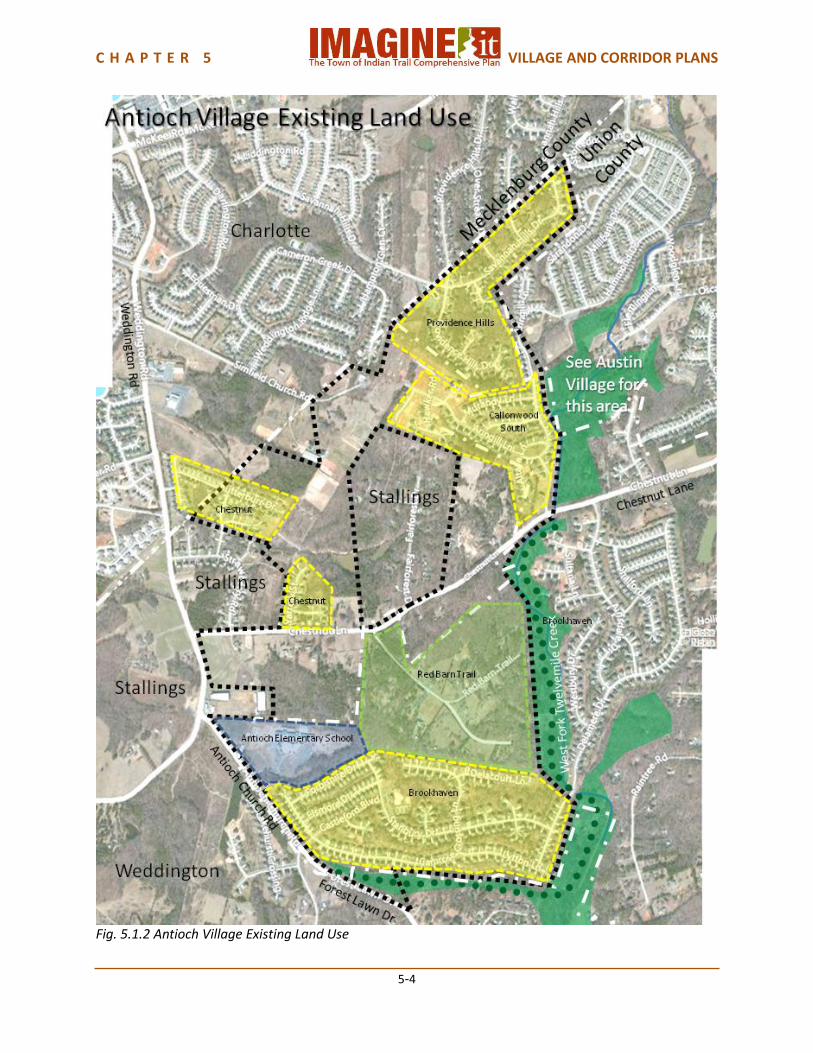
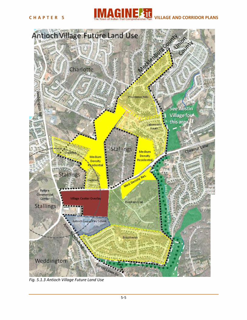
5.1.1 Antioch Village Plan Located at the westernmost edge of Indian Trail, Antioch is a village of single family homes developed mostly since the 1990’s. Being bordered by Charlotte on the north, Stallings on the west and Weddington on the southwest, residents are oriented as much toward those communities as toward Indian Trail, particularly with the Plantation Market neighborhood shopping center a short distance north on Weddington Road. The environment is pleasantly wooded, particularly with the West Fork of Twelve Mile Creek bordering the village on the east side. Antioch Elementary School and a pending neighborhood center development at Weddington Road and Antioch Church Road in Stallings give Antioch a true village structure that will be enhanced with the completion of sidewalks and a greenway trail. Land Use Antioch Village is a Suburban Residential village. The existing subdivisions have largely established its character, which is not expected to change substantially in the future. Future development along Chestnut Lane will be appropriate as Suburban Residential subdivisions. A planned new commercial center in Stallings, at the intersection of Chestnut Lane, Antioch Church Road and Weddington Road will support the Village Center Overlay for Antioch Village. Antioch Elementary School is located as part of the Village Center Overlay. Transportation The section of Chestnut Lane adjacent to the Village Center Overlay should become a 4 Lane Village Center Boulevard. The rest of Chestnut Lane in Antioch Village should become a 4 Lane Boulevard. Both of these typologies provide for bicycle lanes and pedestrian sidewalks. The Indian Trail Parks Master Plan provides for a trail from Weddington Road to Chestnut Lane around the Brookhaven and Red Barn Trail subdivisions, mostly following Twelve Mile Creek. The Bicycle Master Plan provides for a neighborhood loop and a Town-wide loop in this Village. Urban Design Urban design elements in Antioch Village should include an Indian Trail Town Gateway at the intersection of Chestnut Lane and Weddington, and an Antioch Village Identity Marker on Chestnut Lane at or near the West Fork of Twelve Mile Creek. The greenway environment of Twelve Mile Creek should be a part of the Village identity. Village Capacity Antioch Village has an estimated current population of approximately 2,000 people. The future land use plan provides for an additional population capacity of approximately 1,500 people, for a total future population capacity of approximately 3,500 people.
C H A P T E R 5 VILLAGE AND CORRIDOR PLANS
5-4
Fig. 5.1.2 Antioch Village Existing Land Use
C H A P T E R 5 VILLAGE AND CORRIDOR PLANS
5-5
Fig. 5.1.3 Antioch Village Future Land Use

C H A P T E R 5 VILLAGE AND CORRIDOR PLANS
5-6
Fig. 5.1.4 Antioch Village Transportation

C H A P T E R 5 VILLAGE AND CORRIDOR PLANS
5-7
Fig. 5.15 Antioch Village Urban Design

C H A P T E R 5 VILLAGE AND CORRIDOR PLANS
5-8
Fig. 5.1.6 Antioch Village Plan
C H A P T E R 5 VILLAGE AND CORRIDOR PLANS
5-9
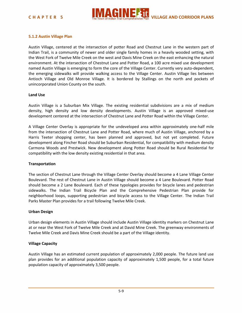
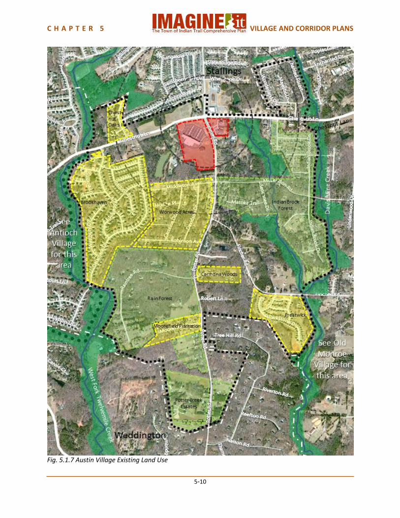
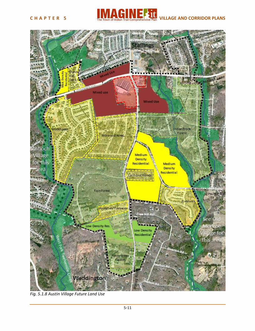
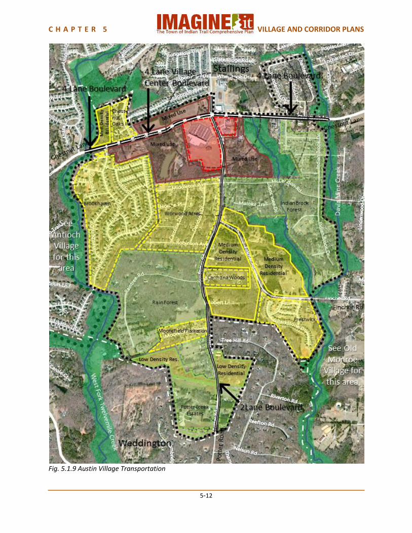
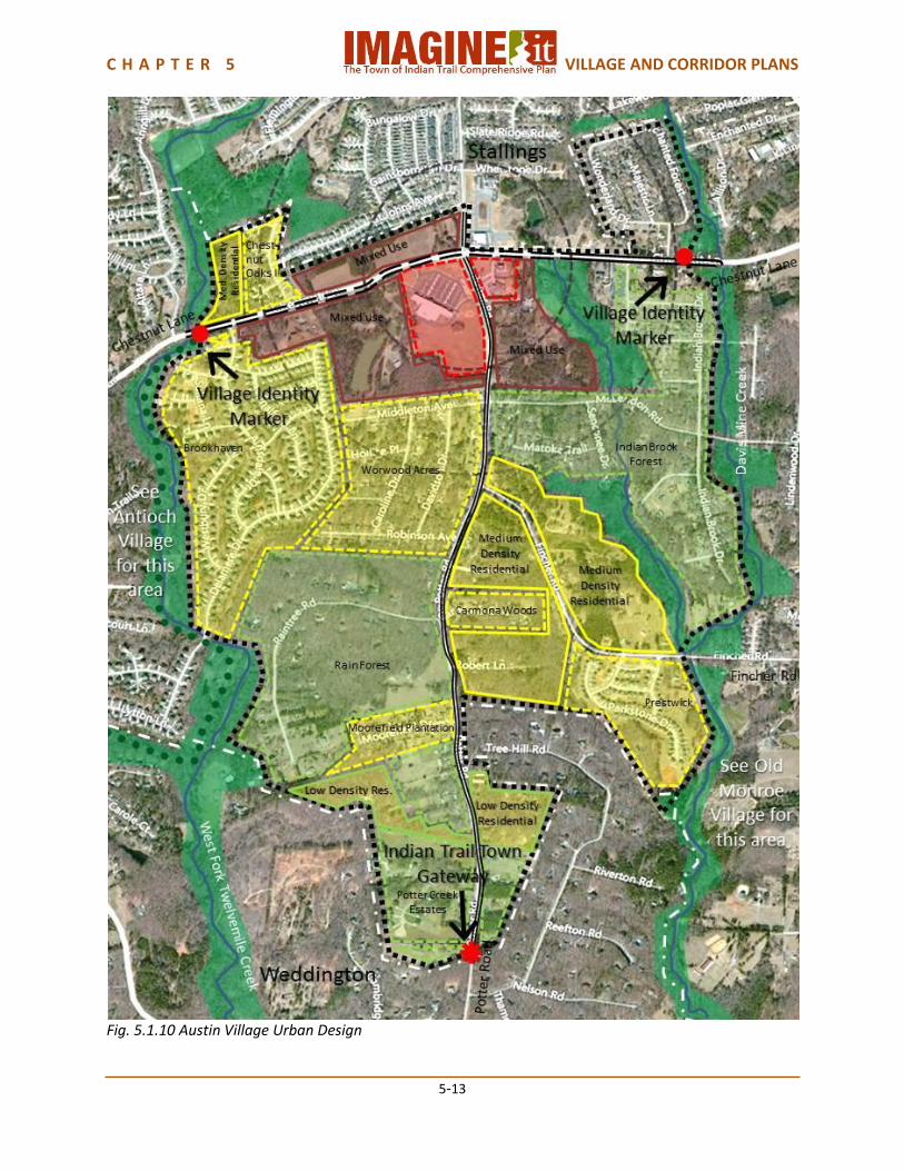
5.1.2 Austin Village Plan Austin Village, centered at the intersection of potter Road and Chestnut Lane in the western part of Indian Trail, is a community of newer and older single family homes in a heavily wooded setting, with the West Fork of Twelve Mile Creek on the west and Davis Mine Creek on the east enhancing the natural environment. At the intersection of Chestnut Lane and Potter Road, a 100 acre mixed use development named Austin Village is emerging to form the core of the Village Center. Currently very auto-dependent, the emerging sidewalks will provide walking access to the Village Center. Austin Village lies between Antioch Village and Old Monroe Village. It is bordered by Stallings on the north and pockets of unincorporated Union County on the south. Land Use Austin Village is a Suburban Mix Village. The existing residential subdivisions are a mix of medium density, high density and low density developments. Austin Village is an approved mixed-use development centered at the intersection of Chestnut Lane and Potter Road within the Village Center. A Village Center Overlay is appropriate for the undeveloped area within approximately one-half mile from the intersection of Chestnut Lane and Potter Road, where much of Austin Village, anchored by a Harris Teeter shopping center, has been planned and approved, but not yet completed. Future development along Fincher Road should be Suburban Residential, for compatibility with medium density Carmona Woods and Prestwick. New development along Potter Road should be Rural Residential for compatibility with the low density existing residential in that area. Transportation The section of Chestnut Lane through the Village Center Overlay should become a 4 Lane Village Center Boulevard. The rest of Chestnut Lane in Austin Village should become a 4 Lane Boulevard. Potter Road should become a 2 Lane Boulevard. Each of these typologies provides for bicycle lanes and pedestrian sidewalks. The Indian Trail Bicycle Plan and the Comprehensive Pedestrian Plan provide for neighborhood loops, supporting pedestrian and bicycle access to the Village Center. The Indian Trail Parks Master Plan provides for a trail following Twelve Mile Creek. Urban Design Urban design elements in Austin Village should include Austin Village identity markers on Chestnut Lane at or near the West Fork of Twelve Mile Creek and at David Mine Creek. The greenway environments of Twelve Mile Creek and Davis Mine Creek should be a part of the Village identity. Village Capacity Austin Village has an estimated current population of approximately 2,000 people. The future land use plan provides for an additional population capacity of approximately 1,500 people, for a total future population capacity of approximately 3,500 people.
C H A P T E R 5 VILLAGE AND CORRIDOR PLANS
5-10
Fig. 5.1.7 Austin Village Existing Land Use
C H A P T E R 5 VILLAGE AND CORRIDOR PLANS
5-11
Fig. 5.1.8 Austin Village Future Land Use
C H A P T E R 5 VILLAGE AND CORRIDOR PLANS
5-12
Fig. 5.1.9 Austin Village Transportation
C H A P T E R 5 VILLAGE AND CORRIDOR PLANS
5-13
Fig. 5.1.10 Austin Village Urban Design

C H A P T E R 5 VILLAGE AND CORRIDOR PLANS
5-14
Fig. 5.1.11 Austin Village Plan
C H A P T E R 5 VILLAGE AND CORRIDOR PLANS
5-15
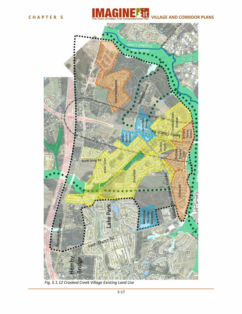
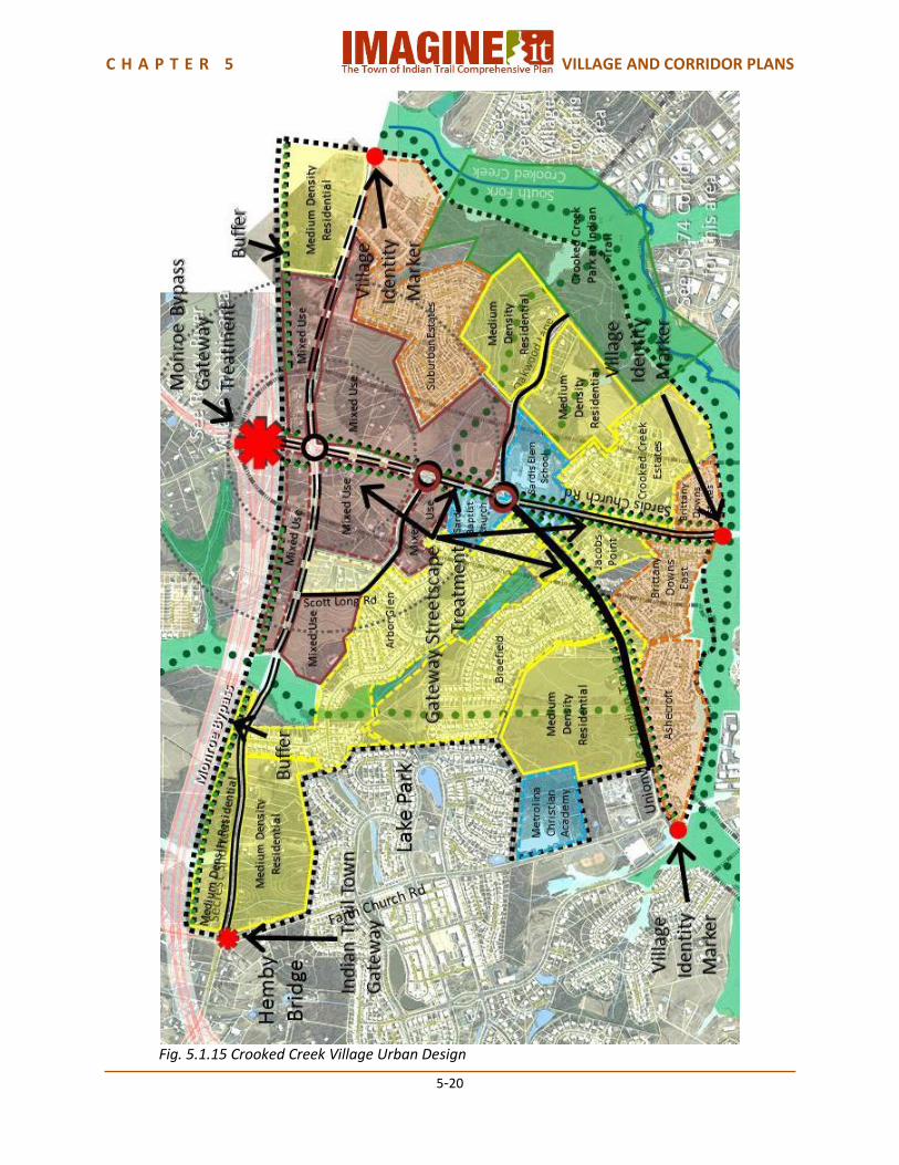
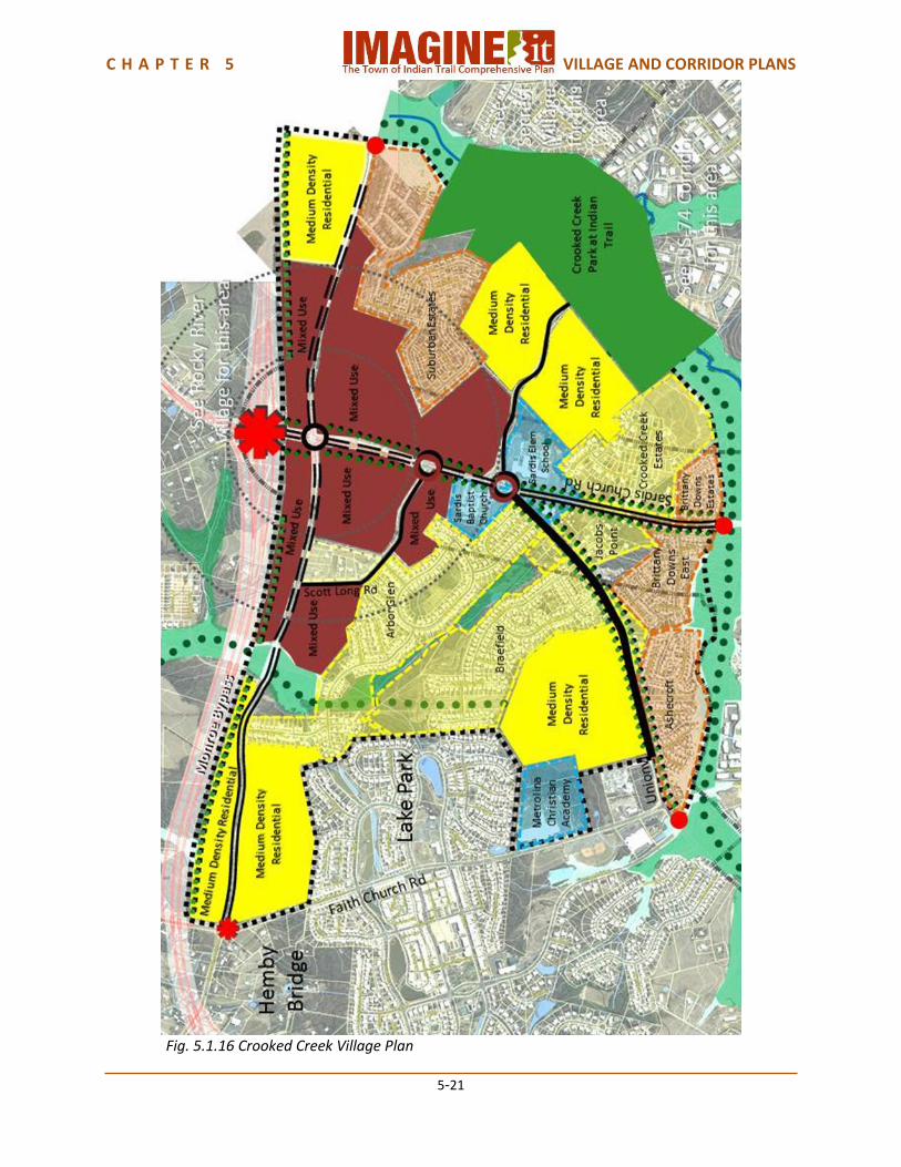
5.1.3 Crooked Creek Village Plan Crooked Creek Village is an area of several high density single family detached subdivisions, bordered on the south by the South Fork of Crooked Creek. Unionville-Indian Trail Road, Sardis Church Road and Secrest Shortcut Road make it very accessible from other areas of Indian Trail, as well as from Hemby Bridge, Stallings and Monroe. The Monroe Bypass will provide regional access to metropolitan Charlotte and Union County as well. The Village of Lake Park on the northeast border of the Village is a master planned community of traditional neighborhood development (TND) that is mostly higher density residential. The Town of Indian Trail has begun development of a regional park, Crooked Creek Park at Indian Trail that will be an attraction for the entire town and neighboring communities. The US-74 Corridor on Crooked Creek Village’s southeast side provides regional access, services and shopping. Sardis Church Road provides direct access to the Sun Valley Sub-regional Center with its shopping and entertainment venues. Over the next decade, completion of the Monroe Bypass tollroad will likely stimulate development of the Village Center around Secrest Shortcut Road and Unionville-Indian Trail Road at the Bypass, where there is a substantial amount of available land for development. Land Use Crooked Creek Village is an Interchange Mix village, located on a Monroe Bypass interchange at Unionville-Indian Trail Road. The existing subdivisions are a mix of medium density and high density subdivisions. At or near the intersection of Unionville-Indian Trail Road and Sardis Church Road are Sardis Elementary School, Sardis Baptist Church and Sunshine Station at Sardis, a childhood development center. Union County has athletic fields at Fred Kirby Park on Faith Church Road in the Village of Lake Park. A Village Center with retail, office and civic uses will be appropriate at the intersection of Unionville-Indian Trail Road and Secrest Shortcut Road, at the Monroe Bypass interchange. Well planned and strategically located light industrial uses will also be appropriate near the Monroe Bypass interchange. The area surrounding the Village Center, within approximately one-half mile of the intersection, will be appropriate as a Village Center Overlay. A major 140 acre Indian Trail park, Crooked Creek Park, is being developed along Crooked Creek at Oakwood Lane. The remaining land within the Village will be appropriate as residential development in varying densities to complete the Suburban Mix development pattern. Transportation Secrest Shortcut Road through the Village Center Overlay should be a 4 Lane Village Center Street, as should Unionville-Indian Trail Road from the Monroe Bypass interchange to the intersection of Unionville-Indian Trail Road and Sardis Church Road. Secrest Shortcut Road from the Village Center Overlay to the Town Limits and Sardis Church Road from its intersection with Unionville-Indian Trail Road to Crooked Creek should be 4 Lane Boulevards. Unionville-Indian Trail Road from its intersection with Sardis Church Road to Crooked Creek should be a 4 Lane Thoroughfare because of limited available right-of-way. Each of these typologies provides for bicycle lanes and pedestrian sidewalks. Roundabout intersections at Unionville-Indian Trail Road’s intersections with Scott Long Road and Sardis Church Road may be desirable because the would allow traffic to move more smoothly through the convergence of several roads, depending on the findings of a detailed traffic analysis, while the Unionville-Indian Trail Road and Secrest Shortcut Road intersection will be signalized. The Indian Trail Parks Master Plan provides for a trail along Crooked Creek, which will be part of the Carolina Thread Trail, and another trail

C H A P T E R 5 VILLAGE AND CORRIDOR PLANS
5-16
following a power line easement between Rocky River Village and Unionville-Indian Trail Road. Town-wide bicycle connectors can be achieved utilizing the Carolina Thread Trail and on-street/off-street bicycle facilities. Urban Design The Monroe Bypass interchange will create a significant gateway for Indian Trail. The Bypass has proposed a very high quality aesthetic design quality for its bridges and interchanges, as described in Chapter 3.8 Urban Design Elements. This could be supplemented by the Town with landscaping and additional streetscape elements. Other urban design elements in Crooked Creek Village should include an Indian Trail Town Gateway on Secrest Shortcut Road at the Hemby Bridge Town Limits, and Crooked Creek Village Identity Markers on Secrest Shortcut Road at Crooked Creek, on Sardis Church Road at Crooked Creek, and on Unionville-Indian Trail Road at Crooked Creek. The greenway environments of Crooked Creek should be a part of the Village Identity. Unionville-Indian Trail Road and Sardis Church Road should receive gateway streetscape treatments, with pedestrian scale lighting, banners, street trees, median plantings and street furnishings. A visual and noise buffer should be provided between the new Village Center Overlay and Suburban Mix developments and the Monroe Bypass. Village Capacity Crooked Creek Village has an estimated current population of approximately 4,000 people. The future land use plan provides for an additional population capacity of approximately 2,000 people, for a total future population capacity of approximately 6,000 people.
C H A P T E R 5 VILLAGE AND CORRIDOR PLANS
5-17
Fig. 5.1.12 Crooked Creek Village Existing Land Use
C H A P T E R 5 VILLAGE AND CORRIDOR PLANS
5-18
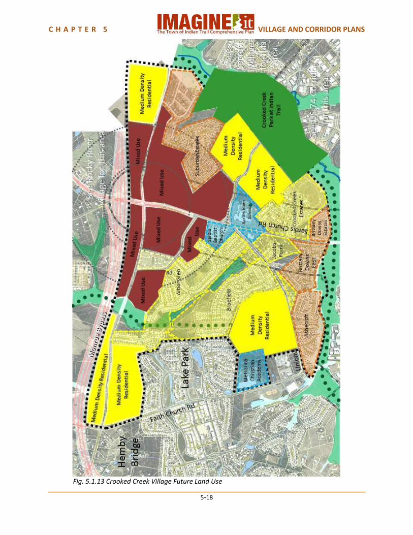
Fig. 5.1.13 Crooked Creek Village Future Land Use

C H A P T E R 5 VILLAGE AND CORRIDOR PLANS
5-19
Fig. 5.1.14 Crooked Creek Village Transportation
C H A P T E R 5 VILLAGE AND CORRIDOR PLANS
5-20
Fig. 5.1.15 Crooked Creek Village Urban Design
C H A P T E R 5 VILLAGE AND CORRIDOR PLANS
5-21
Fig. 5.1.16 Crooked Creek Village Plan
C H A P T E R 5 VILLAGE AND CORRIDOR PLANS
5-22
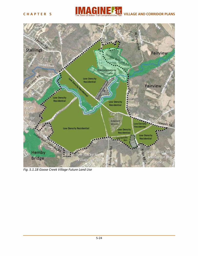
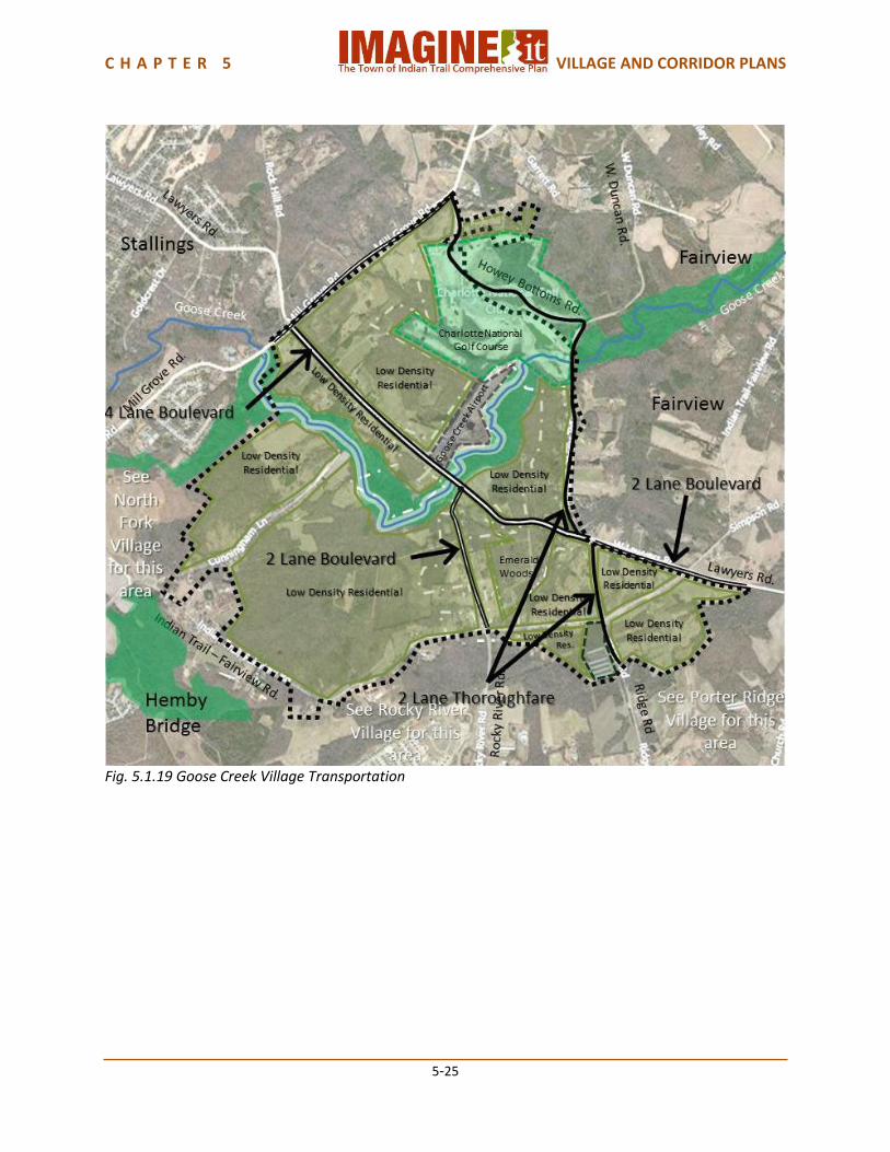
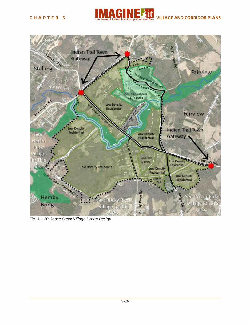
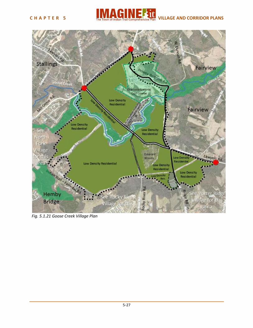
5.1.4 Goose Creek Village Plan Goose Creek Village is a rural area on the north easternmost edge of Indian Trail, bordered by the Town of Stallings and the Town of Hemby Bridge on the west and the Town of Fairview on the East. Rocky River Village and Porter Ridge Village are on its southern side. The Village is very rural, consisting mostly of farmland and some single-family homes on large lots. Goose Creek itself is an environmentally sensitive natural feature. The Town has adopted 200 ft. buffers on both sides of the creek that cannot be developed, a condition required by the Monroe Bypass Environmental Impact Statement and the Federal Fish and Wildlife Services. While the Village Plan provides for conservation development throughout, Goose Creek Village is likely to be one of the slowest growing areas of Indian Trail and to retain its mostly rural feeling for the next decade or two. Land Use Goose Creek Village is a Conservation Development Village, meant to preserve a sense of rural development while protecting a sensitive natural environment. The existing development is primarily agriculture, forested areas, and dispersed single-family residences, with one existing low density subdivision: Emerald Woods. Charlotte National Golf Course is on Howey Bottoms Road along Goose Creek, and the Goose Creek General Aviation Airport is on Lawyers Road. Future land use in this Village should all be Conservation Development, observing the stream buffers along Goose Creek. Conservation developments differ from traditional developments in several ways. Conservation developments, sometimes referred to as cluster development, site homes on smaller lots and there is less emphasis on minimum lot size. However, the total number of homes, or density, on a given acreage does not increase over that allowed in the traditional subdivision designs. The same number of homes is clustered on a smaller portion of the total available land. The remaining land, which would have been allocated to individual home sites, is now converted into protected open space and shared by the residents of the subdivision and possibly the entire community. Transportation Lawyers Road is anticipated to become a 4 Lane Boulevard from the Stallings Town Limit to the intersection with Ridge Road, and a 2 Lane Boulevard from Ridge Road to the Fairview Town Limits. Mill Grove Road and Rocky River Road are anticipated to become 2 Lane Boulevards. Ridge Road and Howey Bottoms Road are anticipated to become 2 Lane Thoroughfares. Each of these typologies provides for bicycle lanes and pedestrian sidewalks. Urban Design Indian Trail Town Gateways should be placed on Lawyers Road at the Town Limits upon entering Goose Creek Village from Stallings and Fairview, and on Mill Grove Road at the Town Limits upon entering Goose Creek Village from Stallings. Village Capacity Goose Creek Village has an estimated current population of approximately 400 people. If the Village were to completely build out, the future land use plan provides for an additional capacity of approximately 4,000 people, for a total future population capacity of approximately 4,000 people.

C H A P T E R 5 VILLAGE AND CORRIDOR PLANS
5-23
Fig. 5.1.17 Goose Creek Village Existing Land Use
C H A P T E R 5 VILLAGE AND CORRIDOR PLANS
5-24
Fig. 5.1.18 Goose Creek Village Future Land Use
C H A P T E R 5 VILLAGE AND CORRIDOR PLANS
5-25
Fig. 5.1.19 Goose Creek Village Transportation
C H A P T E R 5 VILLAGE AND CORRIDOR PLANS
5-26
Fig. 5.1.20 Goose Creek Village Urban Design
C H A P T E R 5 VILLAGE AND CORRIDOR PLANS
5-27
Fig. 5.1.21 Goose Creek Village Plan
C H A P T E R 5 VILLAGE AND CORRIDOR PLANS
5-28
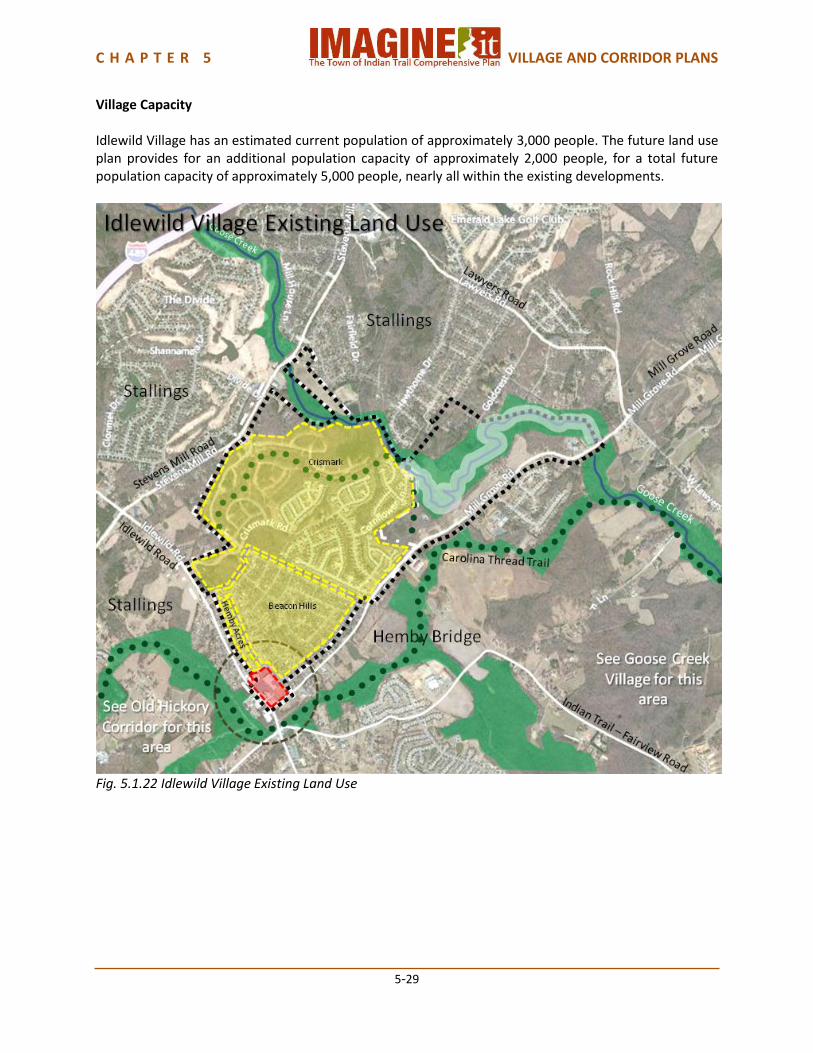
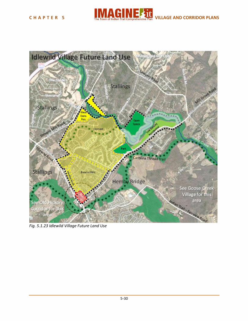
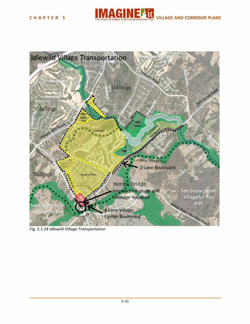
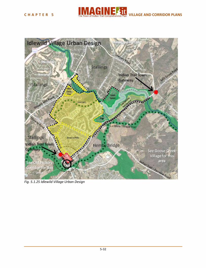
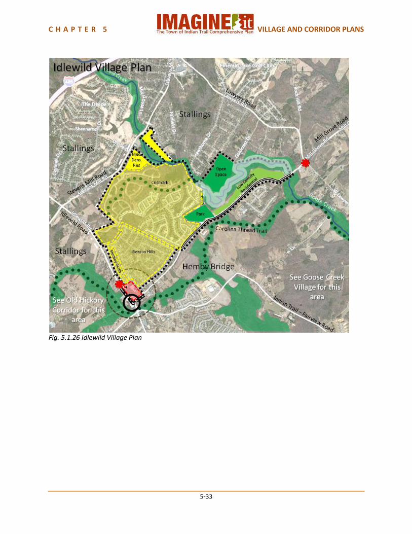
5.1.5 Idlewild Village Plan Idlewild Village is a nearly fully developed Village at the north easternmost edge of Indian Trail, adjacent to the Towns of Stallings and Hemby Bridge. It is close to I-485 along Idlewild Road for regional access to metropolitan Charlotte. Goose Creek runs along its northern edge. Old Hickory Corridor borders Idlewild Village on the south. Goose Creek Village is to the east, but separated from Idlewild Village by the Town of Hemby Bridge. There is an existing Neighborhood Center, Idlewild Commons Shopping Center, at the intersection of Idlewild Road and Mill Grove Road on the southwest corner of the Village. Land Use Idlewild Village is a Suburban Residential village. The existing subdivisions are Crismark, a planned unit development with single family residential, multi-family and future commercial land use, and Beacon Hills, a medium density subdivision that is partially in the Town of Hemby Bridge as well as Indian Trail. Hemby Acres subdivision is next to Beacon Hills. Beacon Hills and Hemby Acres are both built out. There is an existing Neighborhood Center, Idlewild Commons, at the intersection of Lawyers Road and Mill Grove Road. There is little undeveloped or developable land available in the Village. The Crismark subdivision has remaining approved lots that will continue to be built upon as single family detached residences. Future phases which contemplate multifamily and commercial uses will also likely develop. Some additional Suburban Residential development could occur along Stevens Mill Road. The undeveloped area along Mill Grove Road has the potential to be developed as Rural Residential; however, most of that area should be park and/or open space because of the presence of Goose Creek and its stream buffer requirements. Transportation Lawyers Road and Mill Grove Road at their intersection and adjacent to the Neighborhood Center should become 4 Land Village Center Boulevards. The intersection of Lawyers Road and Mill Grove Road requires detailed study and redesign to resolve existing congestion and safety issues. Mill Grove Road from Crismark to Goose Creek should become a 2 Lane Boulevard. Both of these typologies provides for bicycle lanes and pedestrian sidewalks. The Indian Trail Parks Master Plan provides for a trail through Crismark, which should connect to the Carolina Thread Trail in the Town of Hemby Bridge. The Town of Indian Trail Bicycle Plan and Comprehensive Pedestrian Master Plan provide for neighborhood loops throughout the Village, connecting the neighborhoods to each other and to the commercial Neighborhood Center. Urban Design Urban design elements in Idlewild Village should include Indian Trail Town Gateways on Lawyers Road and Mill Grove Road at the Stallings Town Limits. The greenway environment of Goose Creek should be a part of the Village Identity.
C H A P T E R 5 VILLAGE AND CORRIDOR PLANS
5-29
Village Capacity Idlewild Village has an estimated current population of approximately 3,000 people. The future land use plan provides for an additional population capacity of approximately 2,000 people, for a total future population capacity of approximately 5,000 people, nearly all within the existing developments.
Fig. 5.1.22 Idlewild Village Existing Land Use
C H A P T E R 5 VILLAGE AND CORRIDOR PLANS
5-30
Fig. 5.1.23 Idlewild Village Future Land Use
C H A P T E R 5 VILLAGE AND CORRIDOR PLANS
5-31
Fig. 5.1.24 Idlewild Village Transportation
C H A P T E R 5 VILLAGE AND CORRIDOR PLANS
5-32
Fig. 5.1.25 Idlewild Village Urban Design
C H A P T E R 5 VILLAGE AND CORRIDOR PLANS
5-33
Fig. 5.1.26 Idlewild Village Plan

C H A P T E R 5 VILLAGE AND CORRIDOR PLANS
5-34
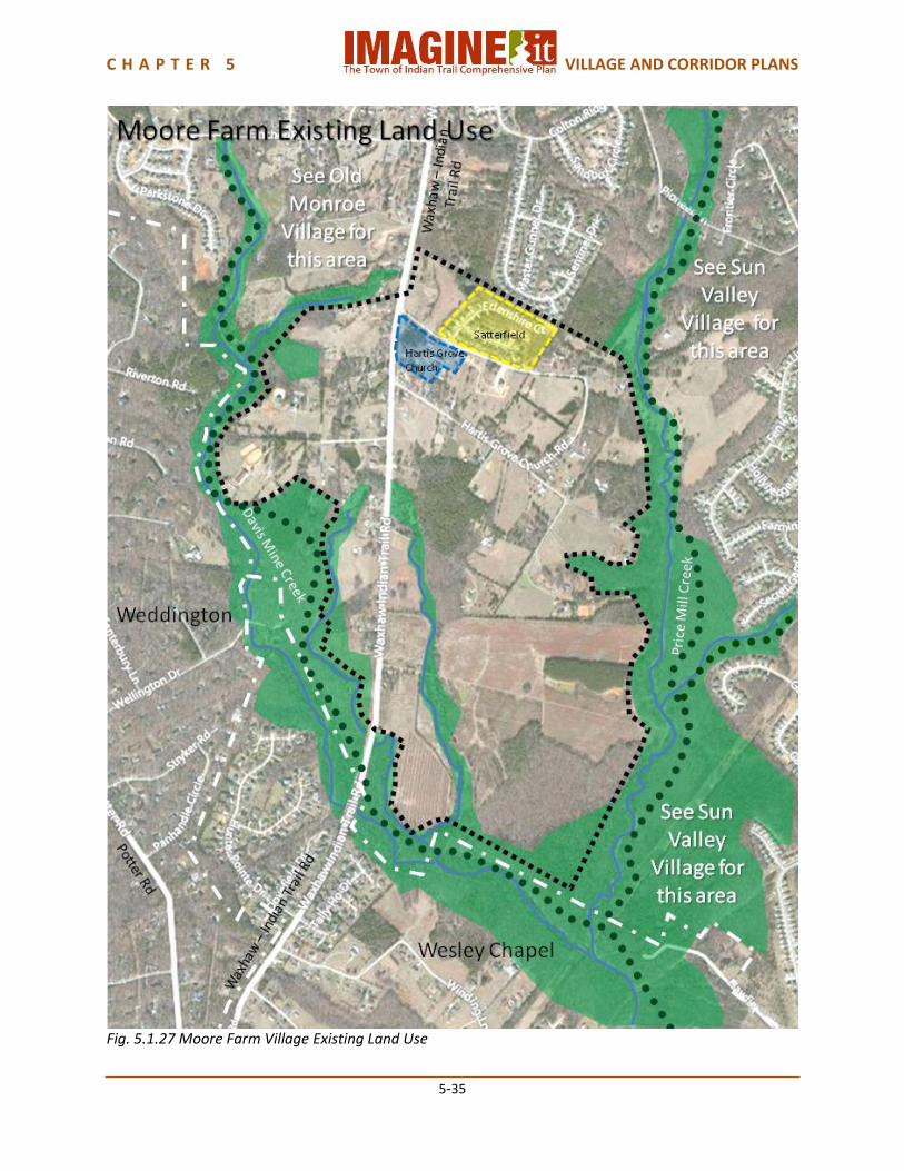
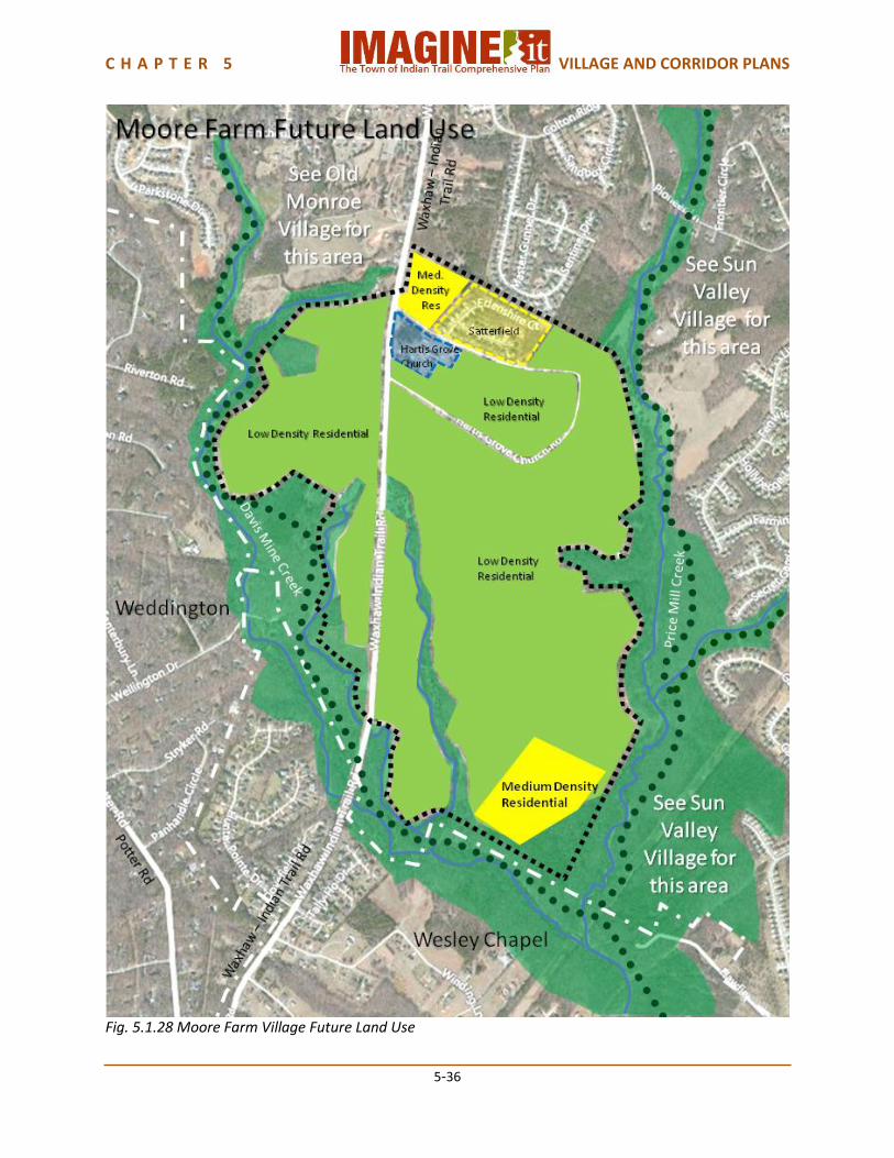
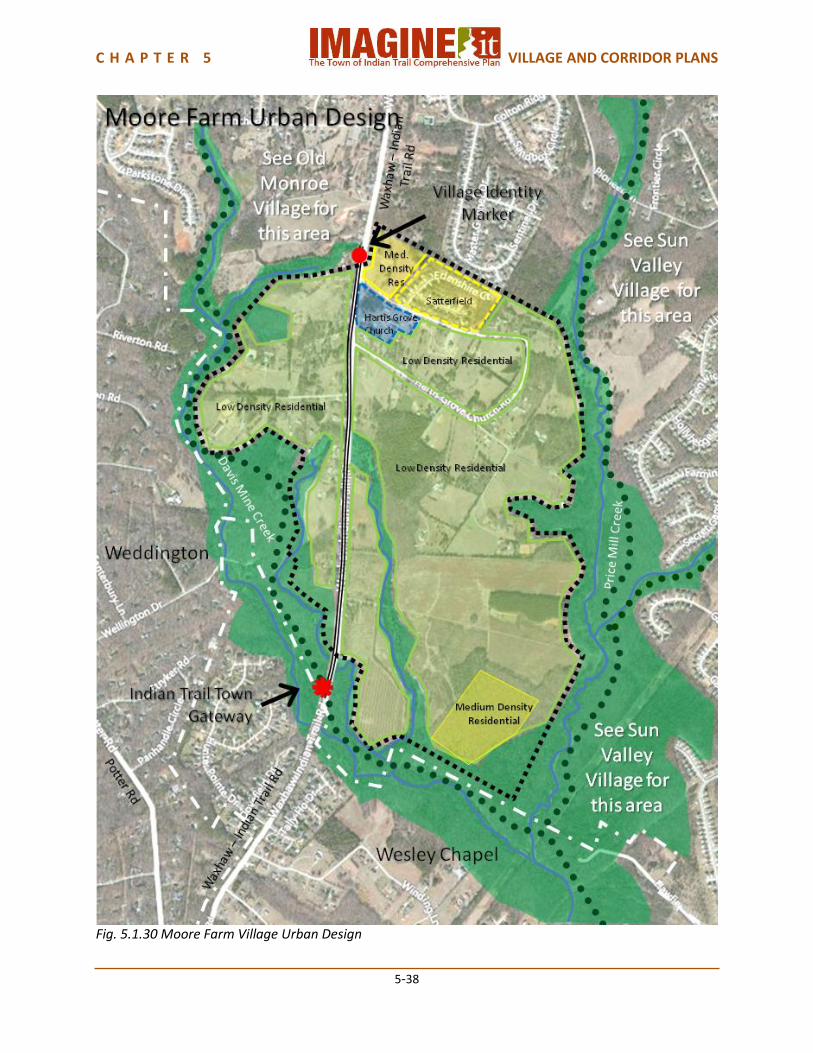
5.1.6 Moore Farm Village Plan Moore Farm is a very rural area along Waxhaw-Indian Trail road, bordered by The Town of Weddington on the west and the Village of Wesley Chapel on the south. Indian Trail’s Old Monroe Village is on the north and Sun Valley on the east, separated from Moore Farm Village by Price Mill Creek. Davis Mine Creek forms the western edge of this Village. With the exception of Hartis Grove Church and the Satterfield subdivision, a small neighborhood, the area is comprised of farmland and homes on farms or large lots. Growth is anticipated to be slow in this Village. The plan reflects the intent to preserve the rural character of the village. Land Use Moore Farm Village is a Rural Mix Village, meant to preserve a sense of rural character. The existing land use is primarily agriculture, forested areas and dispersed single family residences, with one medium density subdivision: Satterfield. Hartis Grove Church is located on Waxhaw-Indian Trail Road at Hartis Grove Church Road. Future land use in this Village should mostly be low density residential. Emphasizing larger lot or conservation-oriented development, this will help preserve Moore Farm Village’s rural atmosphere of farmland and woods. A small area in the southern portion of the Village has been approved as medium density residential as part of Sun Valley Village. Transportation Waxhaw-Indian Trail Road is anticipated to become a 2 Lane Boulevard. This typology provides for bicycle lanes and pedestrian sidewalks. The Indian Trail Parks Master Plan provides for a trail following Price Mill Creek on the east side of Moore Farm Village. A town-wide connector is planned for Waxhaw-Indian Trail Road that would come into the northern edge of Moore Farm. Urban Design An Indian Trail Town Gateway should be placed on Waxhaw-Indian Trail Road at the Town Limits of Wesley Chapel, since it is a gateway into Indian Trail from the west, and a Moore Farm Village Identity Marker on Waxhaw-Indian Trail Road at or near the branch of Davis Mine Creek. This sign may be added later if annexation of the Planning Area within this village continues. The greenway environment of the branch of Davis Mine Creek should be a part of the village identity. Village Capacity Moore Farm Village has an estimated current population of approximately 150 people. If the Village were to completely build out, the future land use plan provides for an additional capacity of 1,300 people, for a total future population capacity of approximately 1,500 people.
C H A P T E R 5 VILLAGE AND CORRIDOR PLANS
5-35
Fig. 5.1.27 Moore Farm Village Existing Land Use
C H A P T E R 5 VILLAGE AND CORRIDOR PLANS
5-36
Fig. 5.1.28 Moore Farm Village Future Land Use

C H A P T E R 5 VILLAGE AND CORRIDOR PLANS
5-37
Fig. 5.1.29 Moore Farm Village Transportation
C H A P T E R 5 VILLAGE AND CORRIDOR PLANS
5-38
Fig. 5.1.30 Moore Farm Village Urban Design

C H A P T E R 5 VILLAGE AND CORRIDOR PLANS
5-39
Fig. 5.1.31 Moore Farm Village Plan
C H A P T E R 5 VILLAGE AND CORRIDOR PLANS
5-40
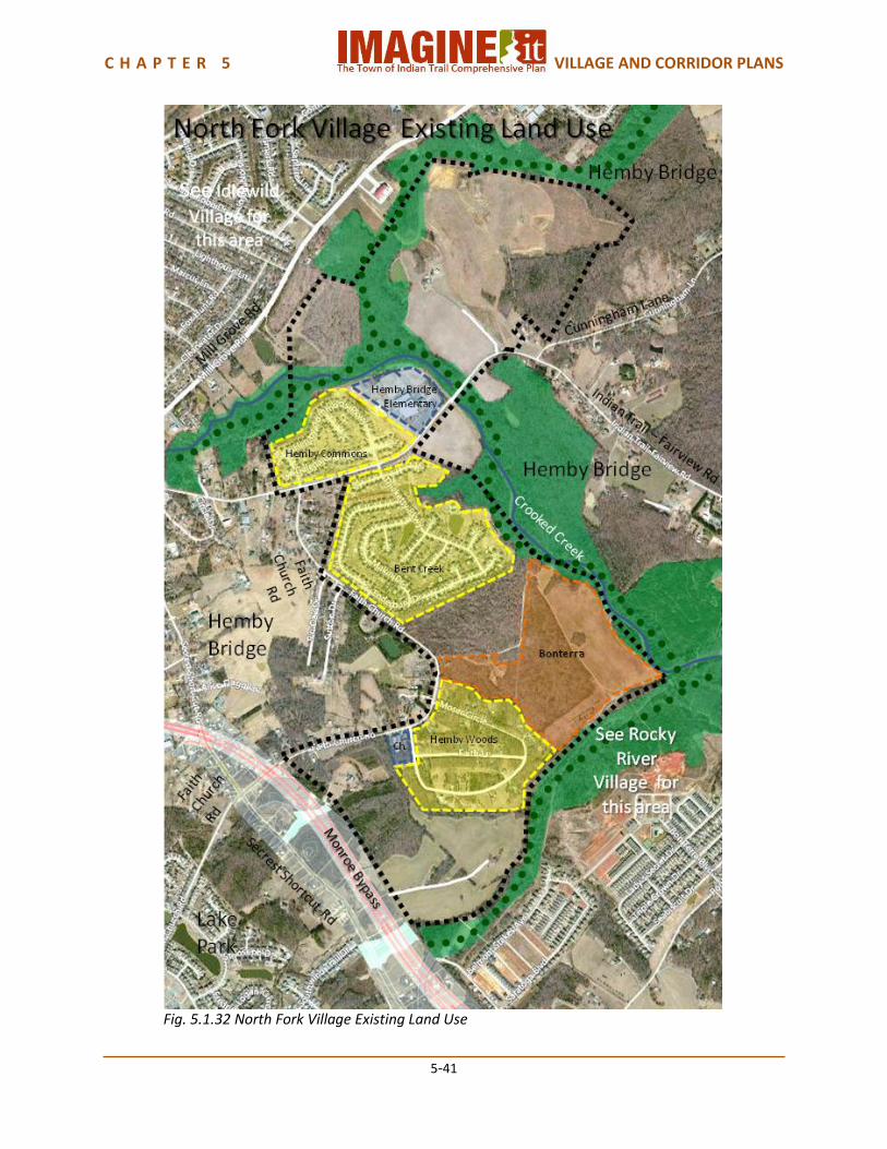
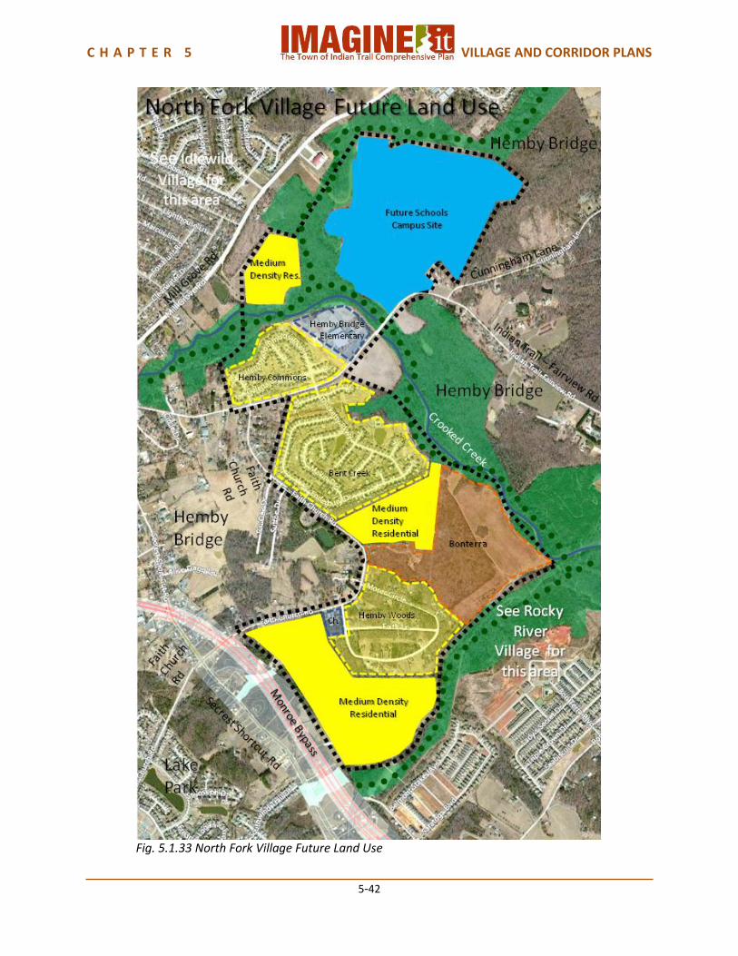
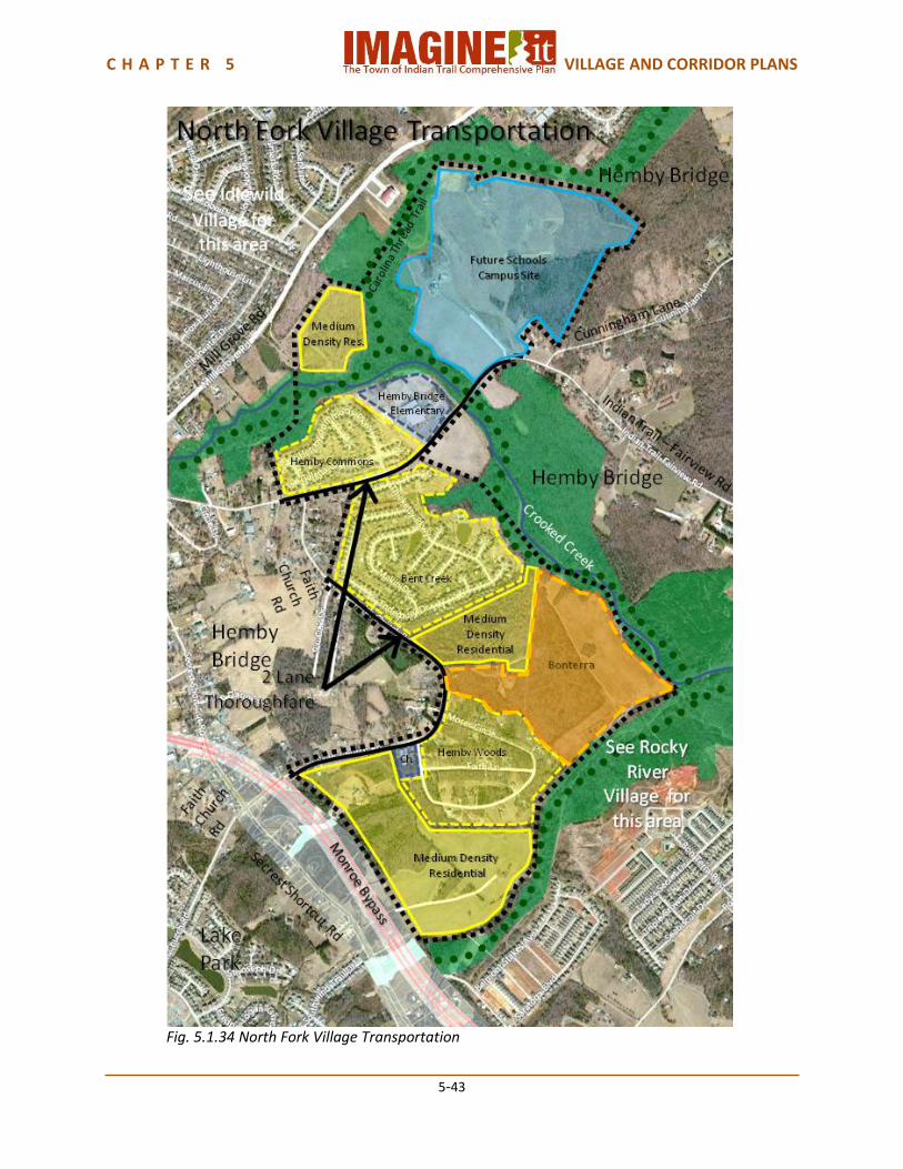
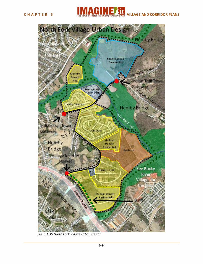
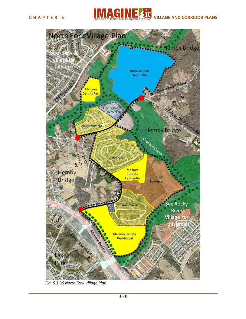
5.1.7 North Fork Village Plan North Fork is a Village of residences ranging from medium density subdivisions to a portion of Bonterra’s traditional neighborhood development to an older wooded subdivision: Hemby Woods. The Town of Hemby Bridge is on both the northeast and southwest sides of the Village. Crooked Creek forms a boundary on three sides of North Fork, and also separates this part of Bonterra from the original part of that development that is in Rocky River Village. Idlewild Village lies to the northwest of North Fork Village, separated by a narrow strip of Hemby Bridge. While the eventual population growth in the Village could reach 4,000 people, a Neighborhood or Village Center has not been identified due to surrounding rural areas and nearby competing Neighborhood and Village Centers. Even though the Monroe Bypass will border North Fork Village on its southwest side, there will not be a bypass interchange. The Villages connections to the rest of Indian Trail are along Faith Church Road and Indian Trail-Fairview Road. Land Use North Fork Village is a Suburban Mix village. The existing development is medium density residential in the Hemby Commons and Bent Creek subdivisions, Traditional Neighborhood Development (TND) in the portion of Bonterra north of Crooked Creek, and medium density residential in the Hemby Woods subdivision. Hemby Bridge Elementary School is on Indian Trail-Fairview Road next to Hemby Commons, and Faith Baptist Church is on Faith Church Road next to Hemby Woods. Union County Public Schools owns approximately 141 acres of land on Unionville-Indian Trail Road adjacent to Hemby Bridge Elementary School within the North Fork Village. This land is planned for use as a potential future Middle and High School Campus. The future land use for this site is identified as Institutional to reflect this future development. Future land use in this Village should be medium density residential in the larger available areas and adjacent to the future school site and in the smaller area between Bent Creek and Bonterra and off of Mill Grove Road. Transportation Faith Church Road and Indian Trail–Fairview Road are anticipated to become 2 Lane Thoroughfares in North Fork Village. This typology provides for bicycle lanes and pedestrian sidewalks, consistent with the Town’s Comprehensive Pedestrian Plan and Bicycle Master Plan. The Indian Trail Parks Master Plan provides for a trail following Crooked Creek, connecting to the Carolina Thread Trail in the Town of Hemby Bridge and to a Crooked Creek trail in Rocky River Village. The Monroe Bypass forms the southwestern boundary of this Village, with an overpass over but no connection to Faith Church Road. Urban Design Indian Trail Town Gateways should be placed on Indian Trail-Fairview Road at the Town Limits of Hemby Bridge, and a North Fork Village Identity Marker on Faith Church Road at the Monroe Bypass. A noise and visual buffer should be provided between the new medium density residential development south of Hemby Woods and the Monroe Bypass. Future development should take into account the location of the Monroe Bypass and incorporate measures to minimize noise and visual impacts. Village Capacity North Fork Village has an estimated current population of approximately 1,000 people. The future land use plan provides for an additional capacity of approximately 3,000 people, for a total future population capacity of approximately 4,400 people.
C H A P T E R 5 VILLAGE AND CORRIDOR PLANS
5-41
Fig. 5.1.32 North Fork Village Existing Land Use
C H A P T E R 5 VILLAGE AND CORRIDOR PLANS
5-42
Fig. 5.1.33 North Fork Village Future Land Use
C H A P T E R 5 VILLAGE AND CORRIDOR PLANS
5-43
Fig. 5.1.34 North Fork Village Transportation
C H A P T E R 5 VILLAGE AND CORRIDOR PLANS
5-44
Fig. 5.1.35 North Fork Village Urban Design
C H A P T E R 5 VILLAGE AND CORRIDOR PLANS
5-45
Fig. 5.1.36 North Fork Village Plan
C H A P T E R 5 VILLAGE AND CORRIDOR PLANS
5-46
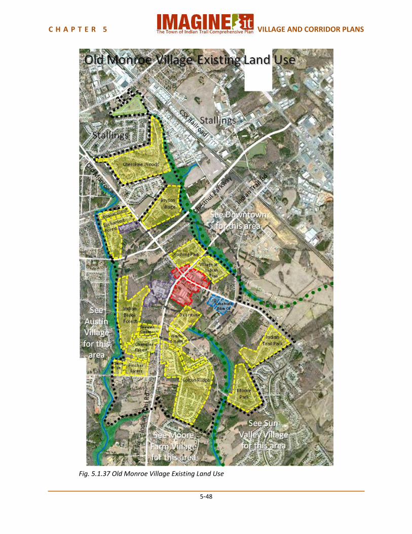
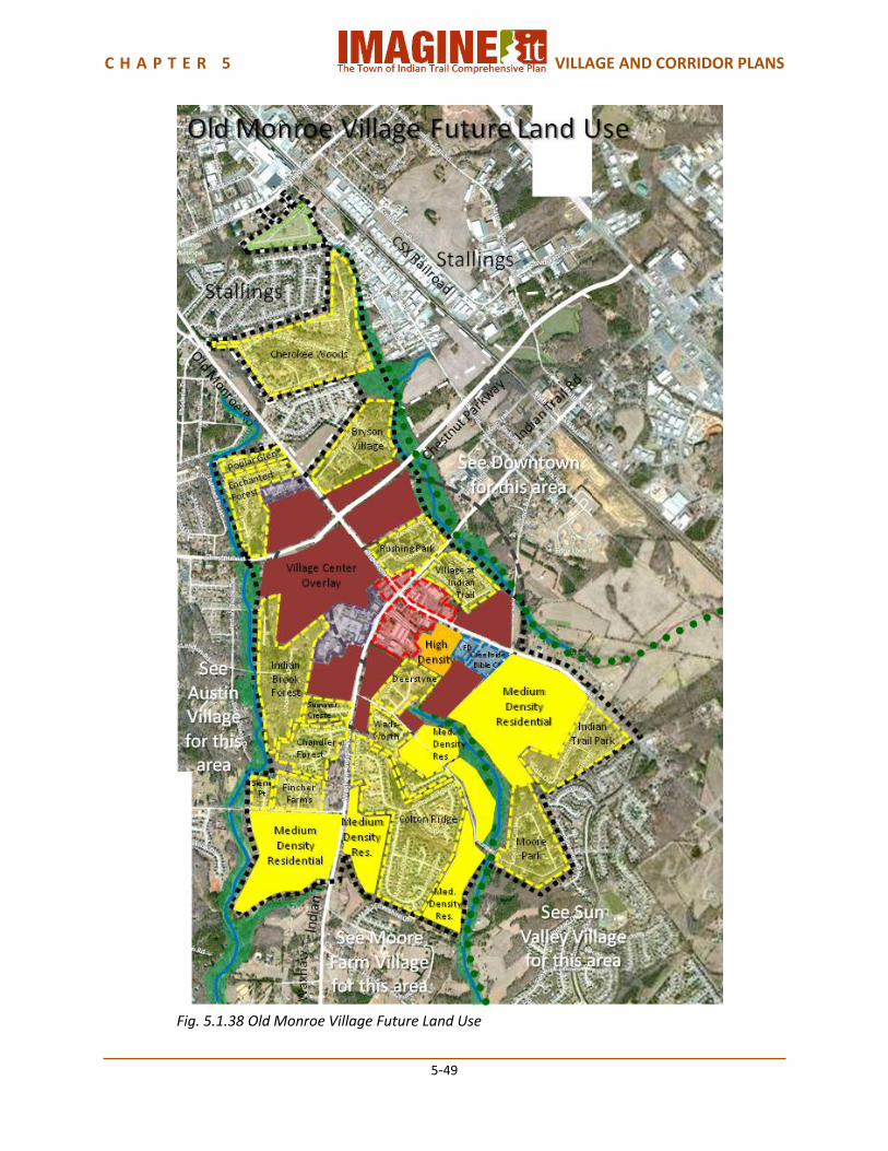
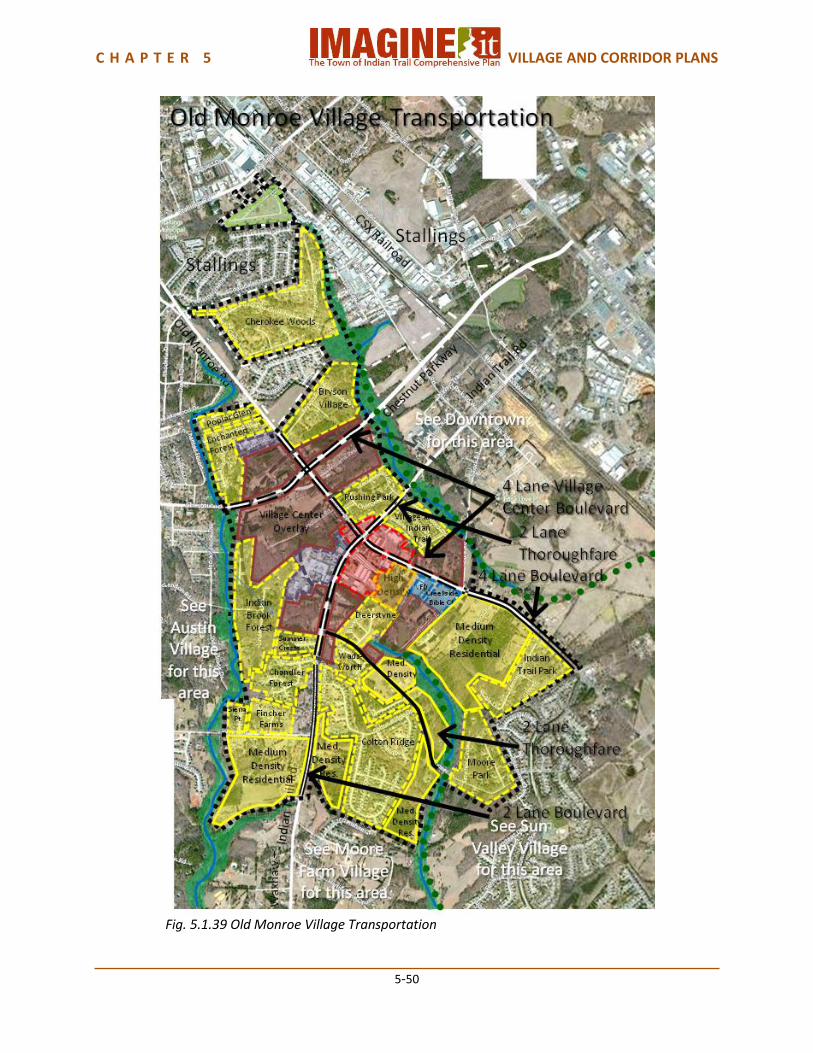
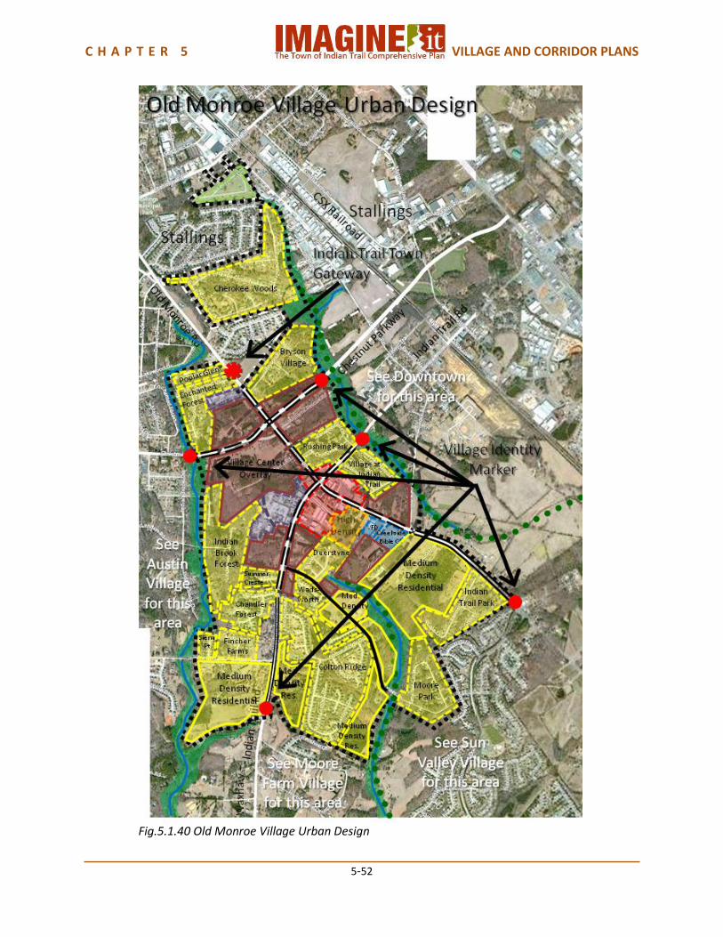
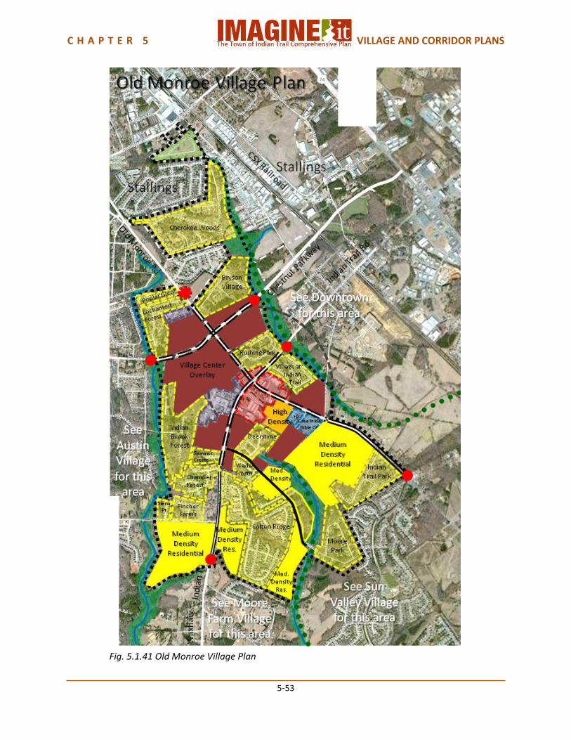
5.1.8 Old Monroe Village Plan Old Monroe Village is one of the older areas of Indian Trail centered on Old Monroe Road and Indian Trail Road and bordered on the east by Crooked Creek and on the west by Davis Mine Creek. When the current congestion on Old Monroe is relieved by the planned widening of this road to a four lane boulevard, this Village should begin to see interest in new development and revitalization. Its proximity to Downtown Indian Trail on the east and the Sun Valley Village Sub-regional Center shopping and entertainment venue should make it an attractive part of Indian Trail. Austin Village borders on the west and Moore Farm Village on the south, while the Town of Stallings forms its northern border. The new Chestnut Parkway will provide improved access to US-74, Chestnut Square at Indian Trail park, and eventually to the villages and corridors within eastern Indian Trail. Land Use Old Monroe Village is a Suburban Mix village. The existing residential development is predominantly medium to low density residential in several subdivisions, which include some of the older residential neighborhood in Indian Trail. There is an existing Village Center at the intersection of Indian Trail Road and Old Monroe Road, which developed before the comprehensive plan Village Center criteria were established. The Stallings Volunteer Fire Department and Creekside Bible Church are on Old Monroe Road. Several industries are on Waxhaw-Indian Trail Road and Old Monroe Road. A small mobile home development is off of Stallings Road, but within the Indian Trail Town Limits. There are also numerous large lot homes that may potentially redevelop in the future. Future land use in this Village is likely to occur in the Village Center Overlay because of the available land and redevelopment potential within approximately one-half mile of the Indian Trail Road and Old Monroe Road intersection. This development will most likely be a mix of commercial, office and high density residential. The remaining developable land within the village will likely be suburban residential. Transportation Old Monroe Road, Waxhaw-Indian Trail Road, Indian Trail Road, Chestnut Lane and Chestnut Parkway should all be Village Center Boulevards within the Village Center Overlay. Old Monroe Road southeast of Creekwood Bible Church should be a 4 Lane Boulevard, and Waxhaw-Indian Trail Road south of the Village Center Overlay should be a 2 Lane Boulevard. These typologies all provide for bicycle lanes and pedestrian sidewalks. The Indian Trail Parks Master Plan provides for trails following the East Fork of Crooked Creek on the east side and Davis Mine Creek in the southern portion. The Indian Trail Bicycle Master Plan and the Comprehensive Pedestrian Plan provide for a Village neighborhood loop. Urban Design An Indian Trail Town Gateway should be located on Old Monroe Road at the Stalling Town Limits, coordinated with the Town’s approved Wayfinding Program. Village Identity markers should be located on Chestnut Parkway at the East Fork of Crooked Creek, Chestnut Lane at Davis Mine Creek, Old Monroe Road at Sun Valley Village, and Waxhaw-Indian Trail Road at the branch of Davis Mine Creek. The creek environments should be incorporated as part of the Village Identity markers wherever possible. Village Capacity Old Monroe Village has an estimated current population of approximately 3,500 people. The future land use plan provides for an additional population capacity of approximately 2,000 people, for a total future population capacity of approximately 5,000 to 6,000 people.

C H A P T E R 5 VILLAGE AND CORRIDOR PLANS
5-47
C H A P T E R 5 VILLAGE AND CORRIDOR PLANS
5-48
Fig. 5.1.37 Old Monroe Village Existing Land Use
C H A P T E R 5 VILLAGE AND CORRIDOR PLANS
5-49
Fig. 5.1.38 Old Monroe Village Future Land Use
C H A P T E R 5 VILLAGE AND CORRIDOR PLANS
5-50
Fig. 5.1.39 Old Monroe Village Transportation

C H A P T E R 5 VILLAGE AND CORRIDOR PLANS
5-51
C H A P T E R 5 VILLAGE AND CORRIDOR PLANS
5-52
Fig.5.1.40 Old Monroe Village Urban Design
C H A P T E R 5 VILLAGE AND CORRIDOR PLANS
5-53
Fig. 5.1.41 Old Monroe Village Plan
C H A P T E R 5 VILLAGE AND CORRIDOR PLANS
5-54
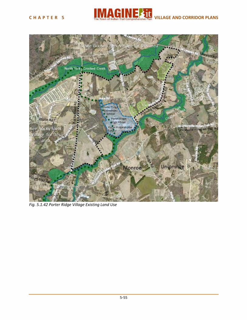
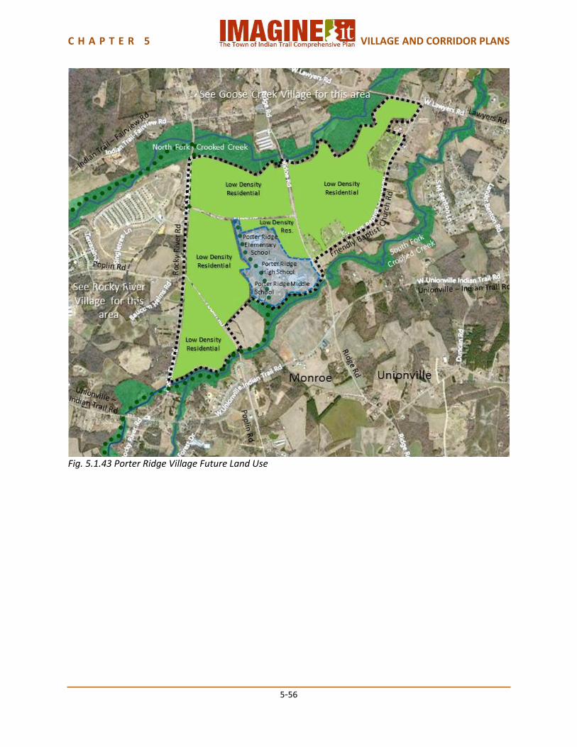
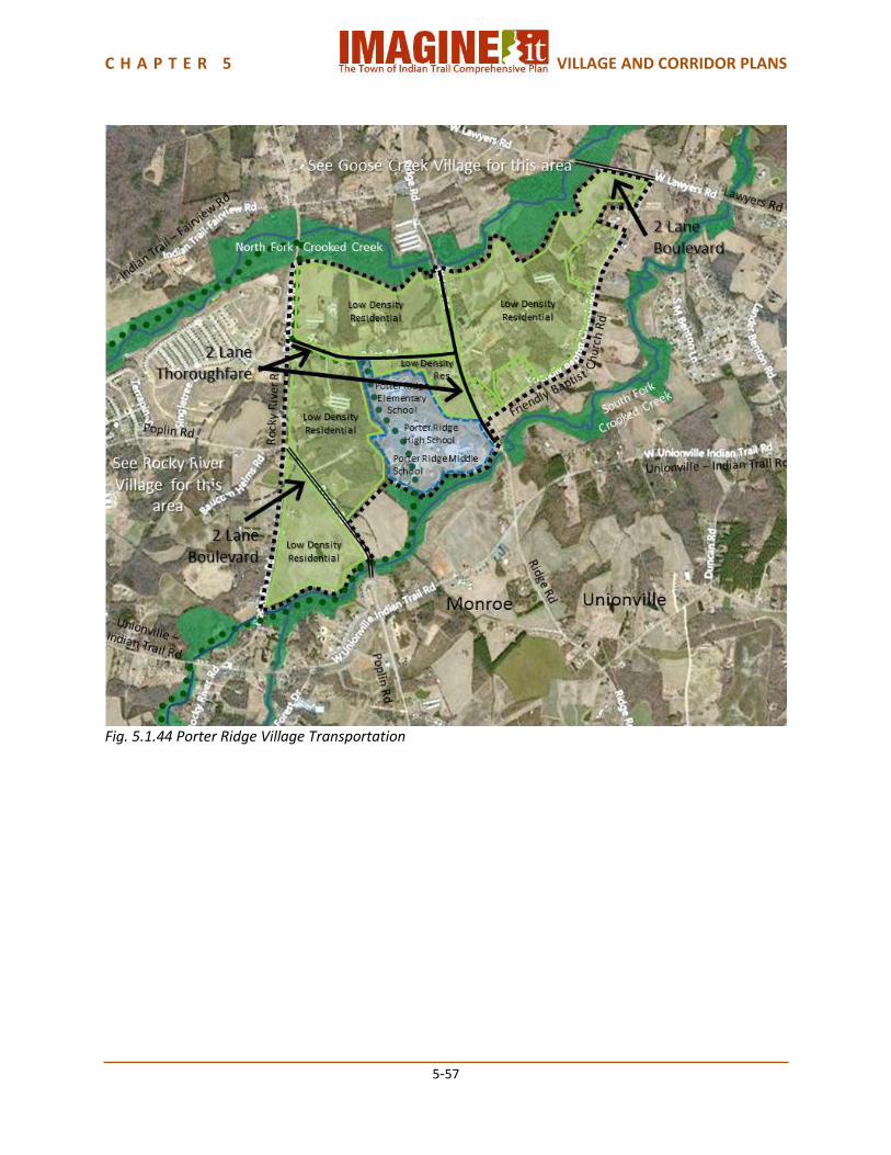
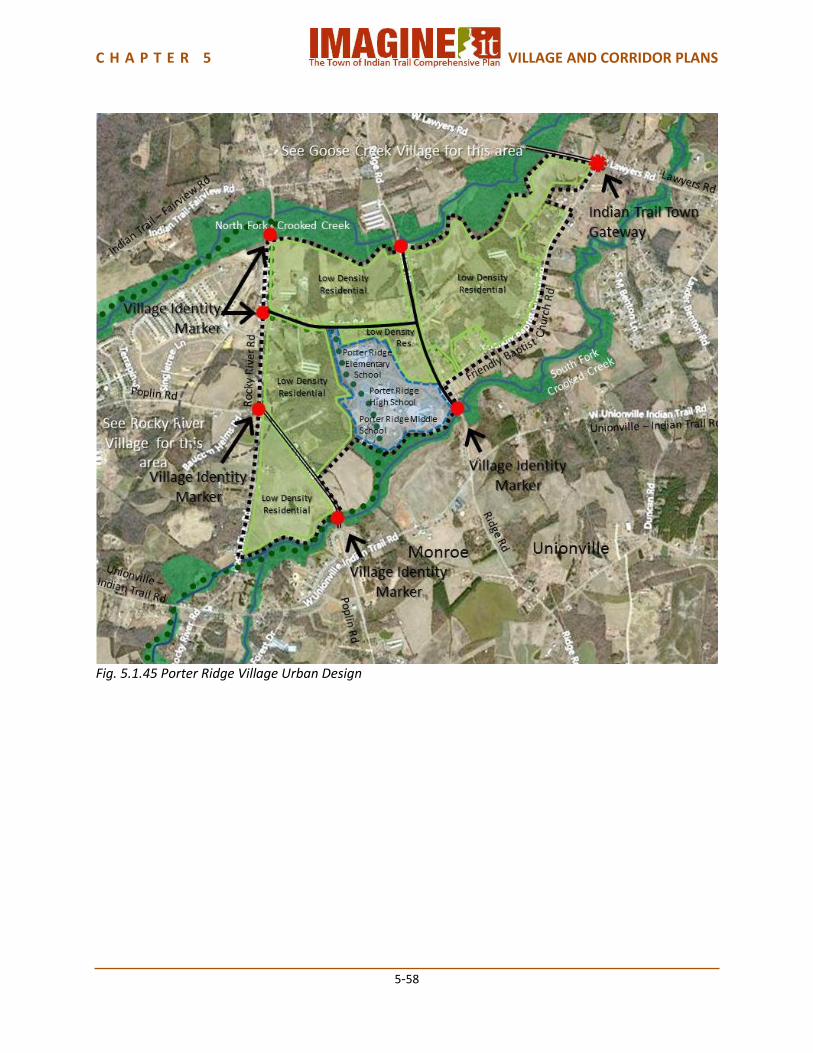
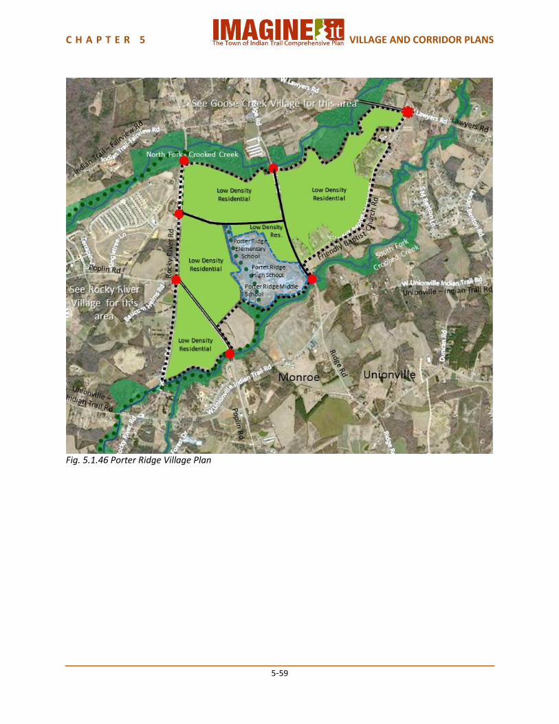
5.1.9 Porter Ridge Village Plan Porter Ridge Village is a very rural, sparsely populated area on the northeast side of Indian Trail. It is unique because the Porter Ridge schools campus is located here, with Porter Ridge High School, Porter Ridge Middle School and Porter Ridge Elementary School. Despite the traffic generated by the schools, the goal is to retain the rural character of this part of Indian Trail. Land Use Porter Ridge Village is a Rural Mix village, meant to preserve a sense of rural development. The existing development is primarily agriculture and dispersed single family residences. The Porter Ridge school campus, with Porter Ridge High School, Porter Ridge Middle School and Porter Ridge Elementary School all located here. Future land use in this Village should all be Rural Mix. A Neighborhood Center planned for the intersection of Poplin Road and Rocky River Road will serve this Village, though none of its non-residential development will be located here. The Neighborhood Center Overlay will all be in Rocky River Village. The Town of Indian Trail Park and Greenway Master Plan indicates a neighborhood park in this Village. Transportation Price Road and Ridge Road are anticipated to become 2 Lane Thoroughfares within Porter Ridge Village. This typology provides for bicycle lanes and pedestrian sidewalks. The sections of Poplin Road and Lawyers Road within this village are anticipated to be 2 Lane Boulevards. The Town’s proposed Greenway/Trail system includes a trail along the South Fork of Crooked Creek providing connectivity to the schools campus. Urban Design An Indian Trail Town Gateway should be placed on Lawyers Road at the Town Limits of Unionville, and Porter Ridge Village Identity Markers on Rocky River Road at the North Fork of Crooked Creek, on Ridge Road at the North Fork of Crooked Creek and the Unionville Town Limits, on Price Road at Rocky River Road, and on Poplin Road at Rocky River Road and the South Fork of Crooked Creek. The greenway environment of the North and South Forks of Crooked Creek should be a part of the Village Identity. Village Capacity Porter Ridge Village has an estimated current population of approximately 300 people. If the Village were to completely build out, the future land use plan provides for an additional capacity of approximately 1,700 people, for a total future population capacity of approximately 2,000 people.
C H A P T E R 5 VILLAGE AND CORRIDOR PLANS
5-55
Fig. 5.1.42 Porter Ridge Village Existing Land Use
C H A P T E R 5 VILLAGE AND CORRIDOR PLANS
5-56
Fig. 5.1.43 Porter Ridge Village Future Land Use
C H A P T E R 5 VILLAGE AND CORRIDOR PLANS
5-57
Fig. 5.1.44 Porter Ridge Village Transportation
C H A P T E R 5 VILLAGE AND CORRIDOR PLANS
5-58
Fig. 5.1.45 Porter Ridge Village Urban Design
C H A P T E R 5 VILLAGE AND CORRIDOR PLANS
5-59
Fig. 5.1.46 Porter Ridge Village Plan

C H A P T E R 5 VILLAGE AND CORRIDOR PLANS
5-60
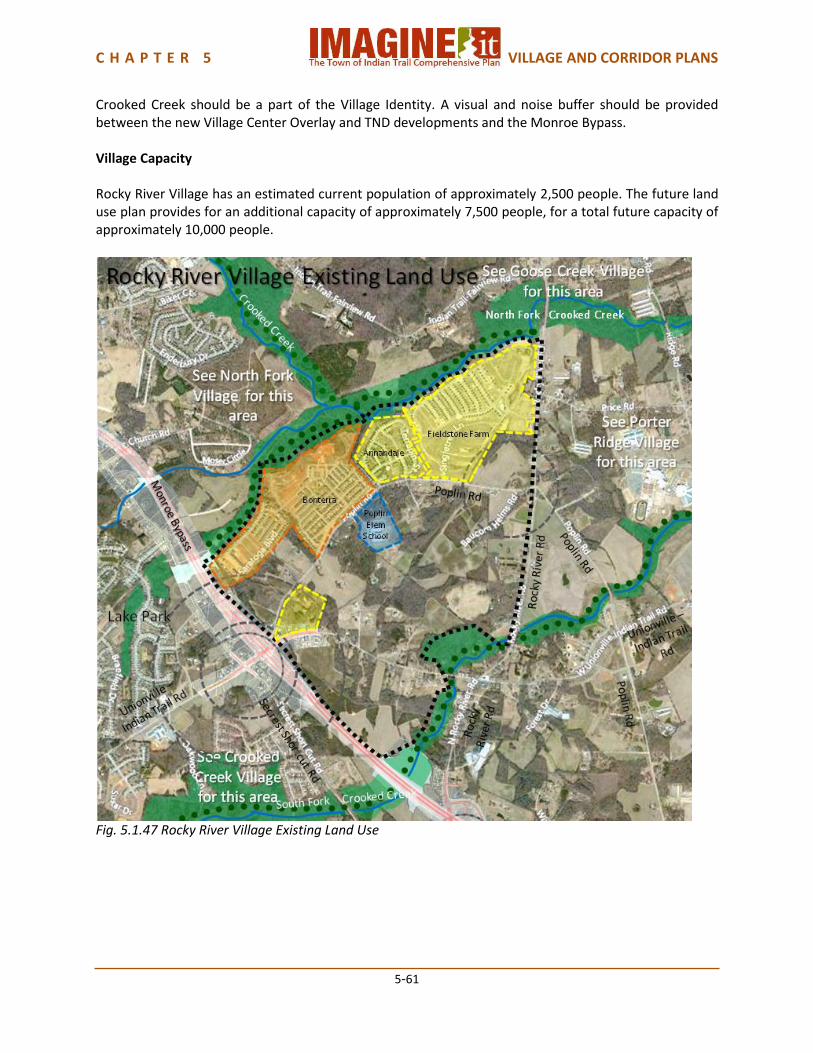
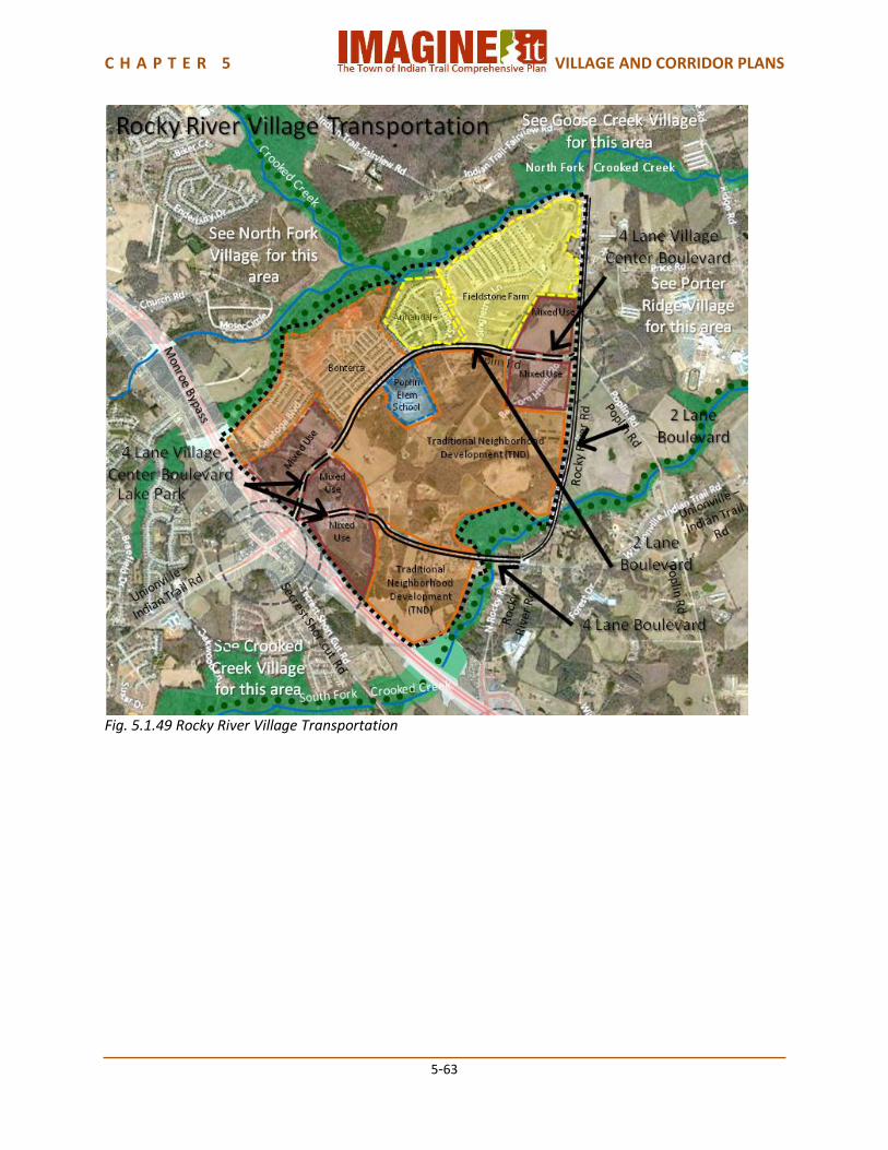
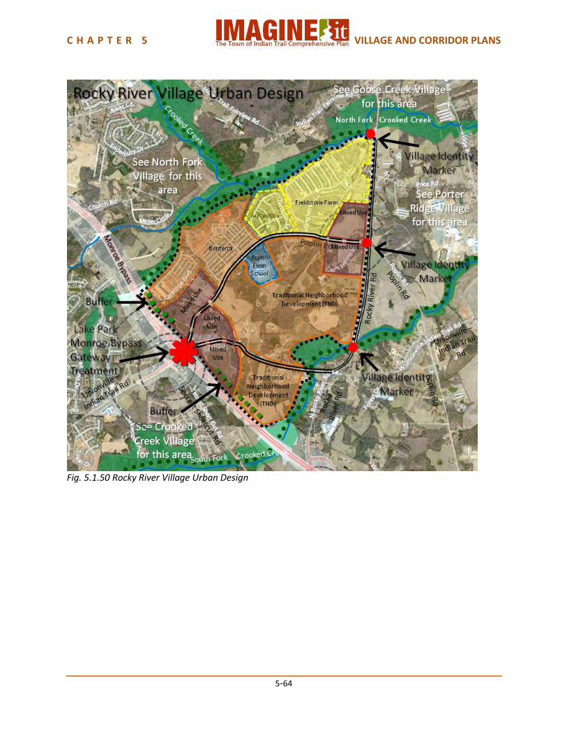
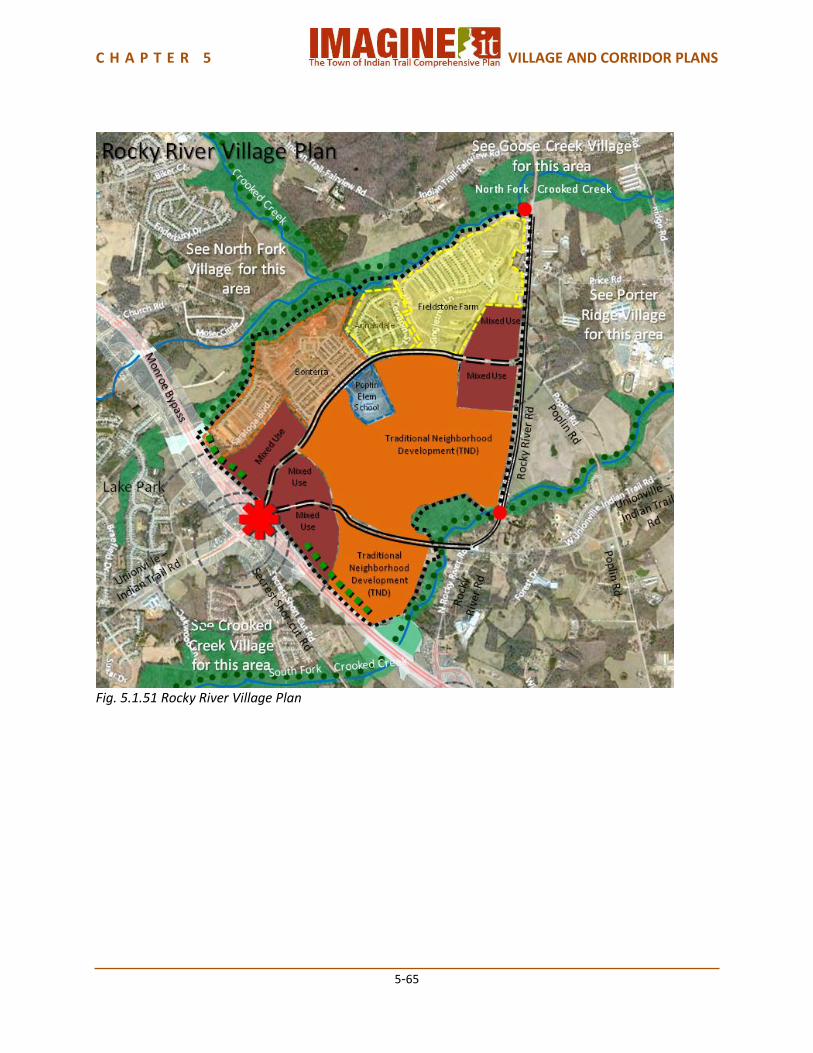
5.1.10 Rocky River Village Plan Rocky River Village development began with the traditional neighborhood development (TND) of Bonterra, which continues to be the model desired for this Village. Bonterra extends across the North Fork of Crooked Creek into North Fork Village, which forms the northern boundary of Rocky River Village. The South Fork of Crooked Creek forms the southern boundary for the Village as well as a boundary with Monroe. The Monroe Bypass will form the western boundary, and the Unionville-Indian Trail interchange will connect Rocky River Village with the Crooked Creek Village Center. Porter Ridge Village on the east is anticipated to maintain its rural atmosphere, but the proximity of the Porter Ridge schools campus will be close to Rocky River Village. The access provided by the Monroe Bypass, Poplin Road, Unionville-Indian Trail Road and Rocky River Road will support the continued development of this Village following the TND model. Land Use Rocky River Village is a Traditional Neighborhood Development (TND) Village, based on the existing Bonterra neighborhood and the ability of the village to support higher densities because of the presence of a Monroe Bypass interchange. Poplin Elementary School is located on Poplin Road across from Bonterra. Future land use in this Village should include a Village Center Overlay at the Monroe Bypass interchange, as part of the Village Center anticipated for Crooked Creek Village at Unionville-Indian Trail Road and Secrest Shortcut Road at the Bypass interchange. A Neighborhood Center planned for the intersection of Poplin Road and Rocky River Road should include a Neighborhood Center Overlay to serve the Bonterra neighborhood and other nearby residences. The remainder of the Village should all be Traditional Neighborhood Development. Transportation The Monroe Bypass will provide an interchange at or near the junction of Poplin Road and Unionville-Indian Trail Road. Poplin Road should become a 2 Lane Boulevard and Unionville-Indian Trail Road should become a 4 Lane Village Center Boulevard in the Village Center. Poplin Road should also become a 2 Lane Village Center Boulevard in the Neighborhood Village Overlay. Poplin Road between the Village Center Overlay and the Neighborhood Center Overlay should become a 2 Lane Boulevard, and Unionville-Indian Trail Road from the Village Center Overlay to the South Fork of Crooked Creek should become a 4 Lane Boulevard. These typologies provide for bicycle lanes and pedestrian sidewalks. The Town of Indian Trail Park Master Plan provides for trails along both the North Fork and South Fork of Crooked Creek. The Indian Trail Bicycle Master Plan and the Comprehensive Pedestrian Plan provide for a neighborhood loop throughout the Village. The pedestrian, bicycle and trail plans will help provide enhanced access to the Porter Ridge school campus, and access under the Monroe Bypass. Urban Design The Monroe Bypass interchange will create a significant gateway for Indian Trail. The Bypass has proposed a very high quality aesthetic design quality for its bridges and interchanges. This could be supplemented by the Town with landscaping and additional streetscape elements. Village Identity Markers should be placed on Rocky River Road at the North Fork of Crooked Creek, at Poplin Road, and at the South Fork of Crooked Creek. The greenway environment of the North and South Forks of
C H A P T E R 5 VILLAGE AND CORRIDOR PLANS
5-61
Crooked Creek should be a part of the Village Identity. A visual and noise buffer should be provided between the new Village Center Overlay and TND developments and the Monroe Bypass. Village Capacity Rocky River Village has an estimated current population of approximately 2,500 people. The future land use plan provides for an additional capacity of approximately 7,500 people, for a total future capacity of approximately 10,000 people.
Fig. 5.1.47 Rocky River Village Existing Land Use

C H A P T E R 5 VILLAGE AND CORRIDOR PLANS
5-62
Fig. 5.1.48 Rocky River Village Future Land Use
C H A P T E R 5 VILLAGE AND CORRIDOR PLANS
5-63
Fig. 5.1.49 Rocky River Village Transportation
C H A P T E R 5 VILLAGE AND CORRIDOR PLANS
5-64
Fig. 5.1.50 Rocky River Village Urban Design
C H A P T E R 5 VILLAGE AND CORRIDOR PLANS
5-65
Fig. 5.1.51 Rocky River Village Plan

C H A P T E R 5 VILLAGE AND CORRIDOR PLANS
5-66
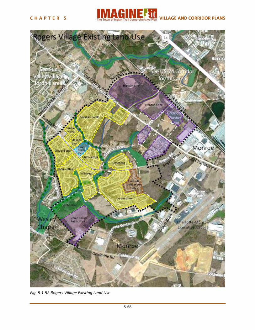
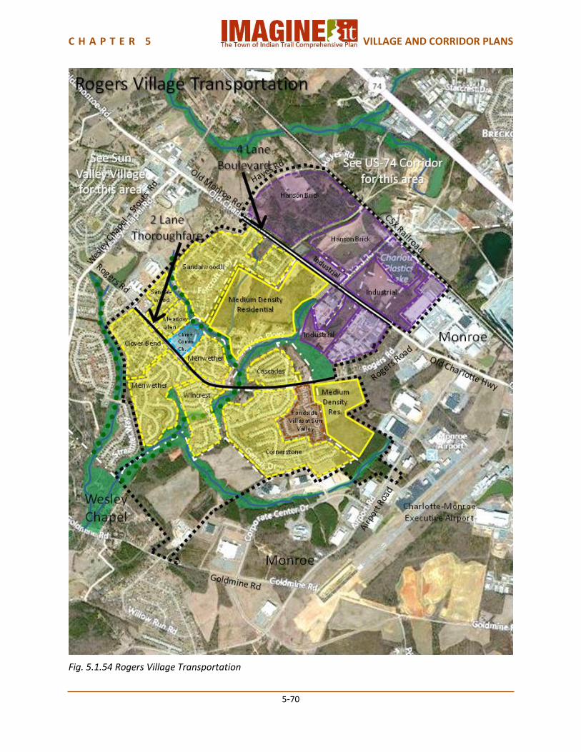
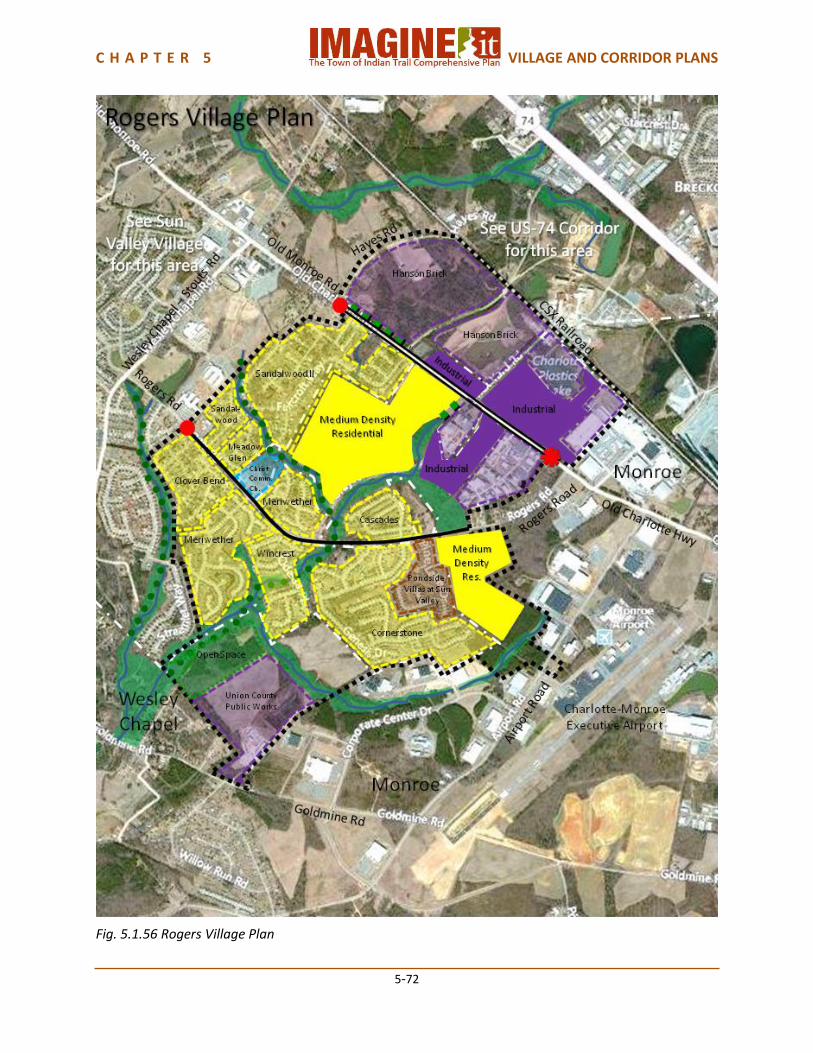
5.1.11 Rogers Village Plan Rogers Village lies at the southeastern –most corner of Indian Trail, adjacent to the City of Monroe. It is a mix of high- and medium-density subdivisions adjacent to Sun Valley Village on the northwest, industrial development along the CSX Railroad on the northeast and unincorporated Union County land on the south. The eastern side of the Village is the Charlotte-Monroe Executive Airport, which influences some of the light industrial development along Old Charlotte Highway in Rogers Village. Twelve Mile Creek meanders throughout the Village, adding a pleasant natural edge to many of the subdivisions. The Sun Valley schools campus abuts Rogers Village on the northwest, with Sun Valley High School, Sun Valley Middle School, Sun Valley Elementary School and Shiloh Elementary School attracting families to the Village. Land Use Rogers Village is a Suburban Mix Village. There are a mix of medium density and high density existing residential subdivisions. There are also industrial properties along Old Charlotte Highway. Part of the large Hanson Brick mining company is partially located in the US-74 Far East Corridor. Union County Public Works has a large property in the southwest corner of the Village, with access from Goldmine Road. Christ Community Church is located on Rogers Road between the Meriwether and Meadow Glen neighborhoods. The Meriwether subdivision in Rogers Village and Brook Valley subdivision in Sun Valley Village have common area open space between the subdivisions and the Union County Public Works properties. Several branches of Twelve Mile Creek run through the Village. While there is no Village Center in this Village, it is served by the Sun Valley Sub-regional Center and Shopping and Entertainment District at Old Charlotte Highway and Wesley Chapel-Stouts Road. Future land use in this Village should include additional medium density residential development off Old Charlotte Highway adjacent to Sandalwood II, and off Rogers Road, to be compatible with the existing residential subdivisions. Additional light industrial development may occur along Old Charlotte Highway as infill among the existing industrial properties, since it is close to the Charlotte-Monroe Executive Airport, the CSX Railroad and existing industrial uses. Transportation Old Charlotte Highway, which is a continuation of Old Monroe Road, should become a 4 Lane Boulevard through Rogers Village, based on the projected traffic volumes described in Chapter 3.6.1 Anticipated Traffic Demand. This typology includes bicycle lanes and pedestrian sidewalks. Rogers Road should be upgraded to a 2 Lane Thoroughfare with the addition of bicycle lanes and pedestrian sidewalks, as well as street trees. The Town of Indian Trail Park and Greenway Master Plan provides for a trail along the East Fork of Twelve Mile Creek from the Sun Valley school campus to the Meriwether/Brook Valley open space area, and along the branch of Twelve Mile Creek on the western edge of Rogers Village. The Indian Trail Bicycle Master Plan and Comprehensive Pedestrian Plan provide for neighborhood loops connecting the Village neighborhoods to the Sun Valley schools campus. Urban Design There should be a Town of Indian Trail Gateway on Old Charlotte Highway at the Monroe City Limits. Village identity markers should be placed on Rogers Road and on Old Charlotte Highway where they join Sun Valley Village. A visual buffer should be considered as part of any new development or
C H A P T E R 5 VILLAGE AND CORRIDOR PLANS
5-67
redevelopment along Old Charlotte Highway to screen the Hanson Brick mining property, and between the new Suburban Mix residential development and the adjacent existing industrial property on Old Charlotte Highway. Village Capacity Rogers Village has an estimated current population of approximately 4,000 people. The future land use plan provides for an additional population capacity of approximately 2,000 people, for a total future population capacity of approximately 6,000 people.
C H A P T E R 5 VILLAGE AND CORRIDOR PLANS
5-68
Fig. 5.1.52 Rogers Village Existing Land Use

C H A P T E R 5 VILLAGE AND CORRIDOR PLANS
5-69
Fig. 5.1.53 Rogers Village Future Land Use
C H A P T E R 5 VILLAGE AND CORRIDOR PLANS
5-70
Fig. 5.1.54 Rogers Village Transportation

C H A P T E R 5 VILLAGE AND CORRIDOR PLANS
5-71
Fig. 5.1.55 Rogers Village Urban Design
C H A P T E R 5 VILLAGE AND CORRIDOR PLANS
5-72
Fig. 5.1.56 Rogers Village Plan
C H A P T E R 5 VILLAGE AND CORRIDOR PLANS
5-73
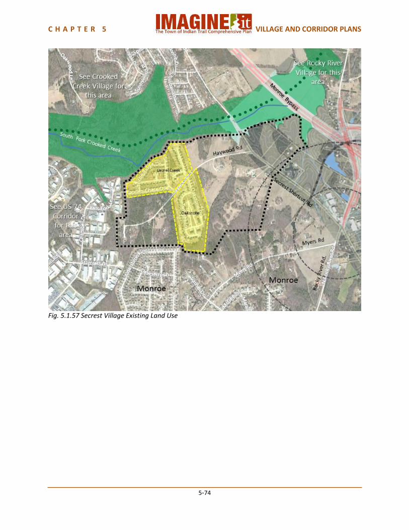
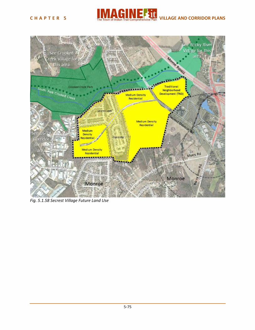
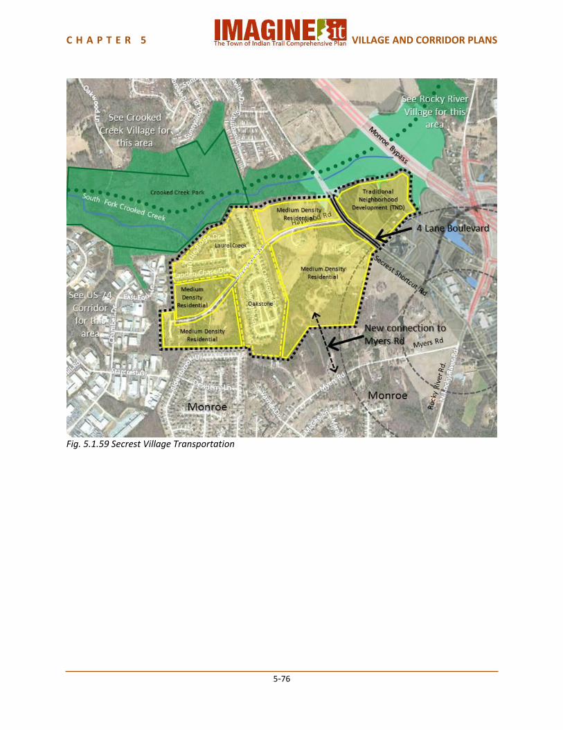
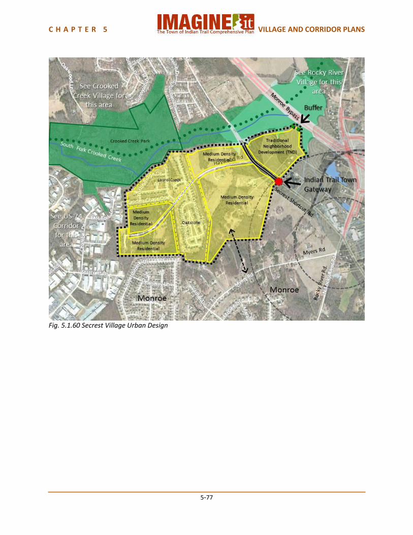
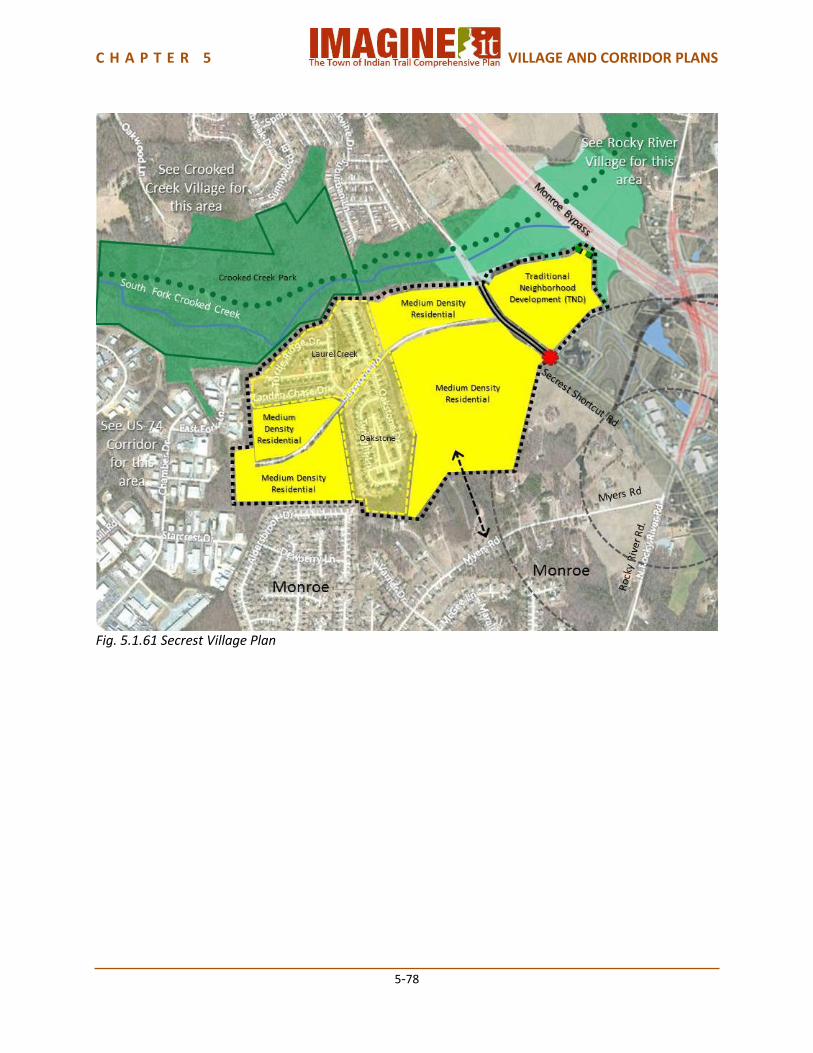
5.1.12 Secrest Village Plan Secrest Village is at the farthest point east in Indian Trail’s planning area, generally located on Secrest Shortcut Road adjacent to the City of Monroe. The South Fork of Crooked Creek on the north separates it from Crooked Creek Village. The US-74 Corridor borders the Village on the west. The Monroe Bypass, on the Village’s northeastern edge will have an interchange at Rocky River Road nearby, and the City of Monroe’s Land Use Plan calls for a Neighborhood Retail Center surrounded by traditional neighborhood development centered on Rocky River Road and Secrest Shortcut Road at the interchange. Most of the land in Secrest Village is currently unincorporated Union County. Coordination of planning for Secrest Village with the City of Monroe will be important. Land Use Secrest Village is a Suburban Mix Village. Existing development consists of two medium density residential subdivisions: Laurel Creek and Oakstone. Future development west of Secrest Shortcut Road should be Suburban Mix residential. The area within the Village east of Secrest Shortcut Road should be Traditional Neighborhood Development (TND), for compatibility with TND development anticipated by the City of Monroe’s Land Use Plan, proximity to that city’s anticipated neighborhood retail center at Secrest Shortcut Road and Rocky River Road, and its closeness to a Monroe Bypass interchange at Rocky River Road. Transportation Secrest Shortcut Road should become a 4 Lane Boulevard through this Village. A new connection to Myers Road should be provided when the new residential development occurs, for additional access to the area west of Secrest Shortcut Road. The Town of Indian Trail Park and Greenway Master Plan provides for a trail from the Crooked Creek Park adjacent to Secrest Village as part of the Carolina Thread Trail. Pedestrian and bicycle connections from the Village to Crooked Creek park will be important. Urban Design There should be a Town of Indian Trail Gateway on Secrest Shortcut Road at the Monroe city limits, coordinated with the Town’s adopted Wayfinding Program. A visual and noise buffer should be considered between the new Traditional Neighborhood Development (TND) and the Monroe Bypass. Village Capacity Secrest Village has an estimated current population capacity of approximately 400 people. The future land use plan provides for an additional population capacity of approximately 1,600 people, for a total future population capacity of approximately 2,000 people.
C H A P T E R 5 VILLAGE AND CORRIDOR PLANS
5-74
Fig. 5.1.57 Secrest Village Existing Land Use
C H A P T E R 5 VILLAGE AND CORRIDOR PLANS
5-75
Fig. 5.1.58 Secrest Village Future Land Use
C H A P T E R 5 VILLAGE AND CORRIDOR PLANS
5-76
Fig. 5.1.59 Secrest Village Transportation
C H A P T E R 5 VILLAGE AND CORRIDOR PLANS
5-77
Fig. 5.1.60 Secrest Village Urban Design
C H A P T E R 5 VILLAGE AND CORRIDOR PLANS
5-78
Fig. 5.1.61 Secrest Village Plan
C H A P T E R 5 VILLAGE AND CORRIDOR PLANS
5-79
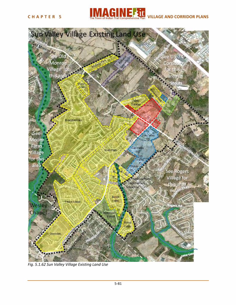
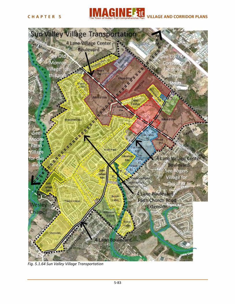
5.1.13 Sun Valley Village Plan Sun Valley is the largest of the Indian Trail Villages, characterized particularly by the Brandon Oaks subdivision, Union County’s largest residential neighborhood and the Sun Valley schools campus, which is one of the oldest campuses in the Union County School District. It is served by Old Monroe Road and Wesley Chapel/Wesley Chapel-Stouts Roads. The CSX Railroad forms the northeastern boundary of the Village. The west side is bordered by Price Mill Creek, which separates it from Moore Farm Village. Old Monroe Village borders Sun Valley to the west along Old Monroe Road, and Rogers Village borders Sun Valley the southeast. The Village of Wesley Chapel forms the southern boundary of the Village. The commercial center at Old Monroe Road and Wesley Chapel Road is becoming a Sub-regional Center which is planned to be the Town’s Shopping and Entertainment District for shopping, dining and other activities. The sub-regional classification developed through the natural merger of the previously identified Sagecroft Village Center (in original Comprehensive Plan) with Sun Valley. The highlight attraction in Sun Valley is the Stone Movie Theater, which is the only theater in western Union County and anchors the Sun Valley Commons Shopping Center. This district needs a small area plan to be completed to further articulate the shopping and entertainment district concepts. Land Use Sun Valley Village is a Suburban Mix Village. The area southwest of Old Monroe Road is largely built out or committed as part of existing subdivisions. Sun Valley Sub-regional Center is anchored by the intersection of Old Monroe Road and Wesley Chapel-Stouts Road, and continues to develop. The Sun Valley school campus is located at the southeast corner of the Old Charlotte Highway/Wesley Chapel Road intersection, including Sun Valley High School, Sun Valley Middle School, Sun Valley Elementary School, and Shiloh Elementary School. Land to the northeast of Old Monroe Road/Old Charlotte Highway includes three smaller medium density subdivisions, one low density residential area and one industrial property, and part of the Sub-regional Center, but also includes the most undeveloped land in the Village. In addition to the currently developing Sub-regional Center, Sagecroft Village has been approved for development along Old Monroe Road where the planned Faith Church Road Extension will cross. Sagecroft Village will include a commercial center and single family detached and attached residential development, as well as a future Town park. Because of the intensity of commercial development that will occur, all of the remaining vacant land along Old Monroe Road is designated as a Village Center Overlay. Three remaining small areas off Wesley Chapel Road are designated as medium density residential, for compatibility with the existing surrounding subdivisions. Transportation Old Monroe Road and Wesley Chapel-Stouts Roads should become 4 Lane Village Center Boulevards through Sun Valley Village. Wesley Chapel Road should become a 4 Lane Village Center Boulevard from the intersection with Old Monroe Road past Sun Valley Middle School, and a 4 Lane Boulevard from there to the Wesley Chapel Town Limits. The Faith Church Road extension should be built as a 4 Lane Boulevard. These typologies are based on the projected traffic volumes described in Chapter 3.7 Anticipated Roadway Travel Demand. These typologies all include bicycle lanes and pedestrian sidewalks. The Town of Indian Trail Park and Greenway Master Plan provides for a trail along the East Fork of Twelve Mile Creek from the Sun Valley school campus to the Meriwether/Brook Valley open
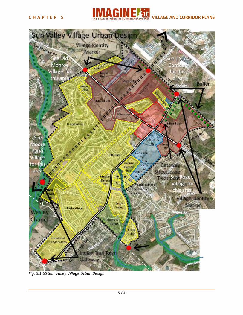
C H A P T E R 5 VILLAGE AND CORRIDOR PLANS
5-80
space area, and along Price Mill Creek on the western edge of Sun Valley Village. The trails will connect to the Union County Carolina Thread Trail. The Indian Trail Bicycle Master Plan and the Comprehensive Pedestrian Plan include provisions for a neighborhood bicycle and pedestrian loop through the Village. Urban Design There should be a Town of Indian Trail Gateway on Wesley Chapel Road and on the Faith Church Road Extension at the Wesley Chapel town limits. Village Identity Markers should be placed on Old Monroe Road where it joins Old Monroe Village and Rogers Village, and on Wesley Chapel-Stouts Road at the CSX Railroad line. A visual and noise buffer should be provided between the new Village Center Overlay and the CSX Railroad. Wesley Chapel-Stouts Road, which is an entrance to Indian Trail from the Monroe Bypass, should receive gateway streetscape treatments, with pedestrian scale lighting, banners, street trees, median plantings and street furnishings. Village Capacity Sun Valley Village has an estimated current population of approximately 9,500 people. The future land use plan provides for an additional capacity of approximately 2,000 people, for a total future capacity of approximately 12,000 people. Most of the future residential growth will be in the Village Center Overlay.
C H A P T E R 5 VILLAGE AND CORRIDOR PLANS
5-81
Fig. 5.1.62 Sun Valley Village Existing Land Use
C H A P T E R 5 VILLAGE AND CORRIDOR PLANS
5-82
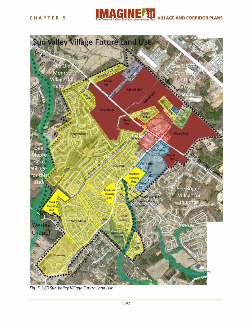
Fig. 5.1.63 Sun Valley Village Future Land Use
C H A P T E R 5 VILLAGE AND CORRIDOR PLANS
5-83
Fig. 5.1.64 Sun Valley Village Transportation
C H A P T E R 5 VILLAGE AND CORRIDOR PLANS
5-84
Fig. 5.1.65 Sun Valley Village Urban Design
C H A P T E R 5 VILLAGE AND CORRIDOR PLANS
5-85
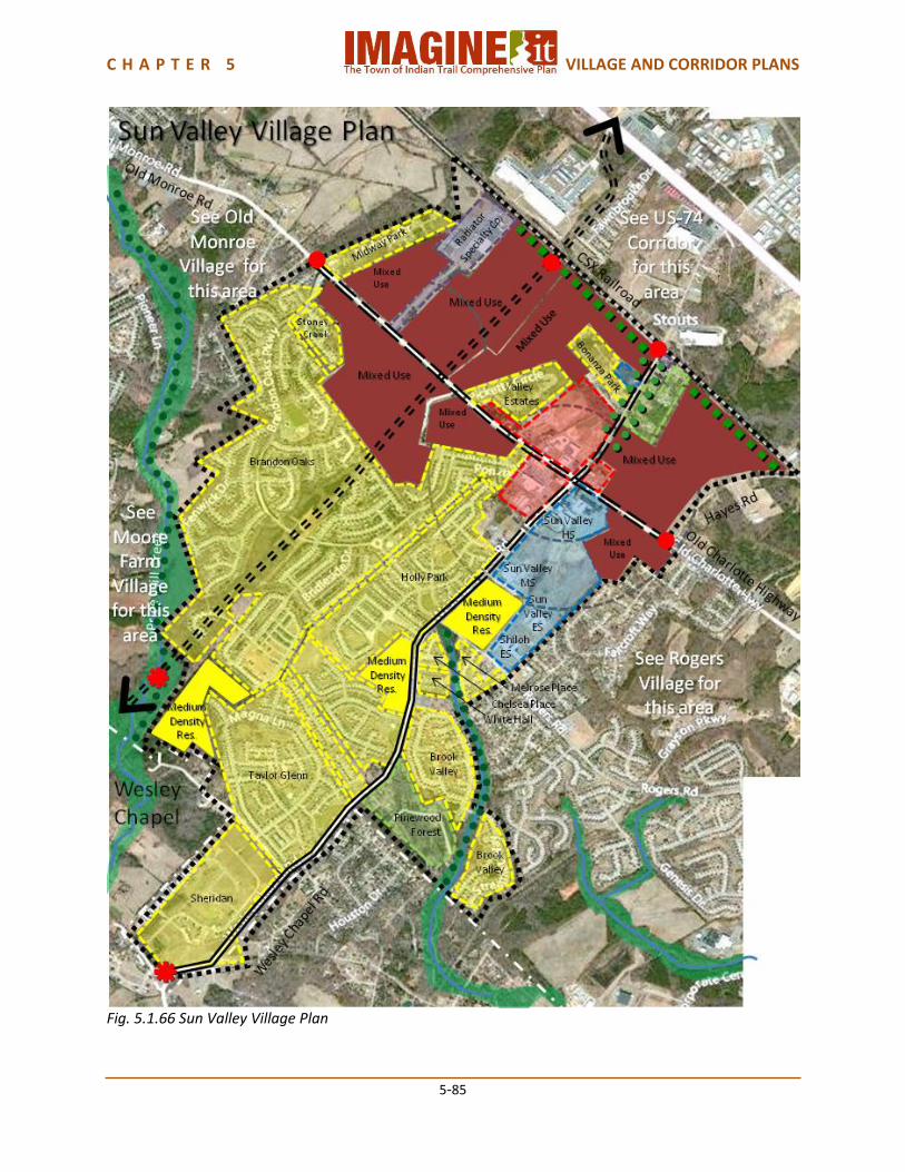
Fig. 5.1.66 Sun Valley Village Plan
C H A P T E R 5 VILLAGE AND CORRIDOR PLANS
5-86
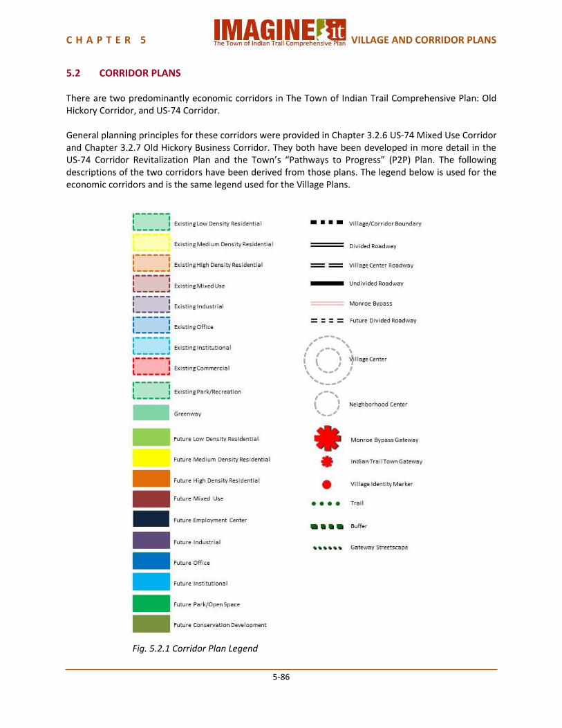
5.2 CORRIDOR PLANS There are two predominantly economic corridors in The Town of Indian Trail Comprehensive Plan: Old Hickory Corridor, and US-74 Corridor. General planning principles for these corridors were provided in Chapter 3.2.6 US-74 Mixed Use Corridor and Chapter 3.2.7 Old Hickory Business Corridor. They both have been developed in more detail in the US-74 Corridor Revitalization Plan and the Town’s “Pathways to Progress” (P2P) Plan. The following descriptions of the two corridors have been derived from those plans. The legend below is used for the economic corridors and is the same legend used for the Village Plans.
Fig. 5.2.1 Corridor Plan Legend
C H A P T E R 5 VILLAGE AND CORRIDOR PLANS
5-87
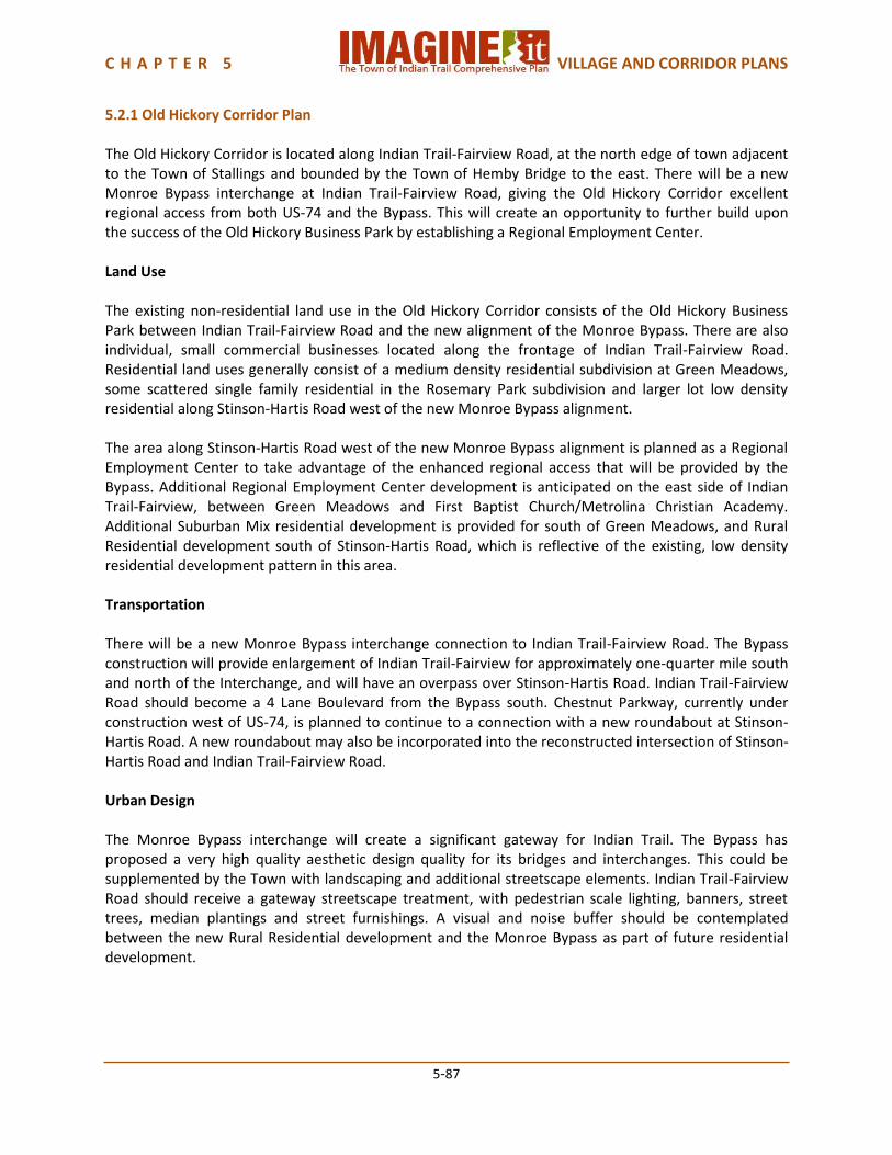
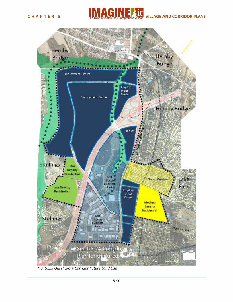
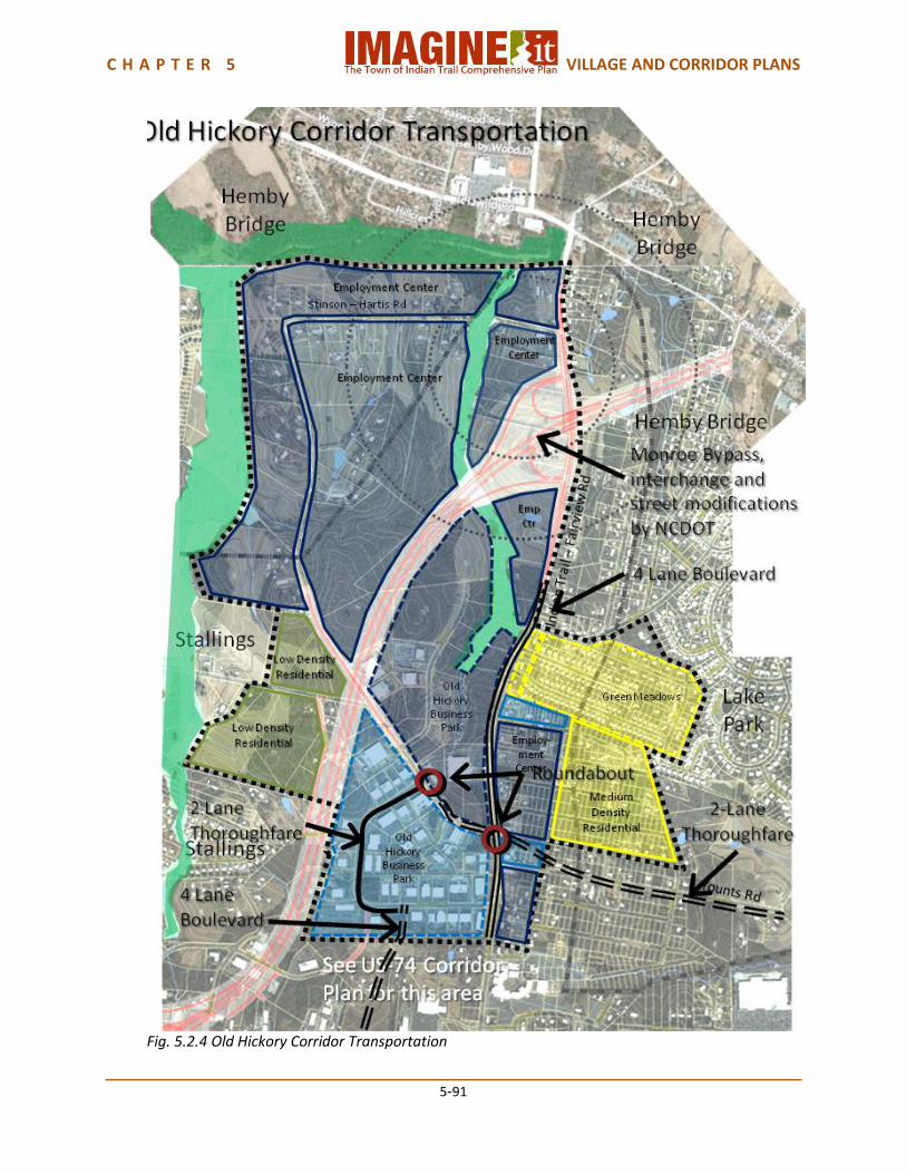
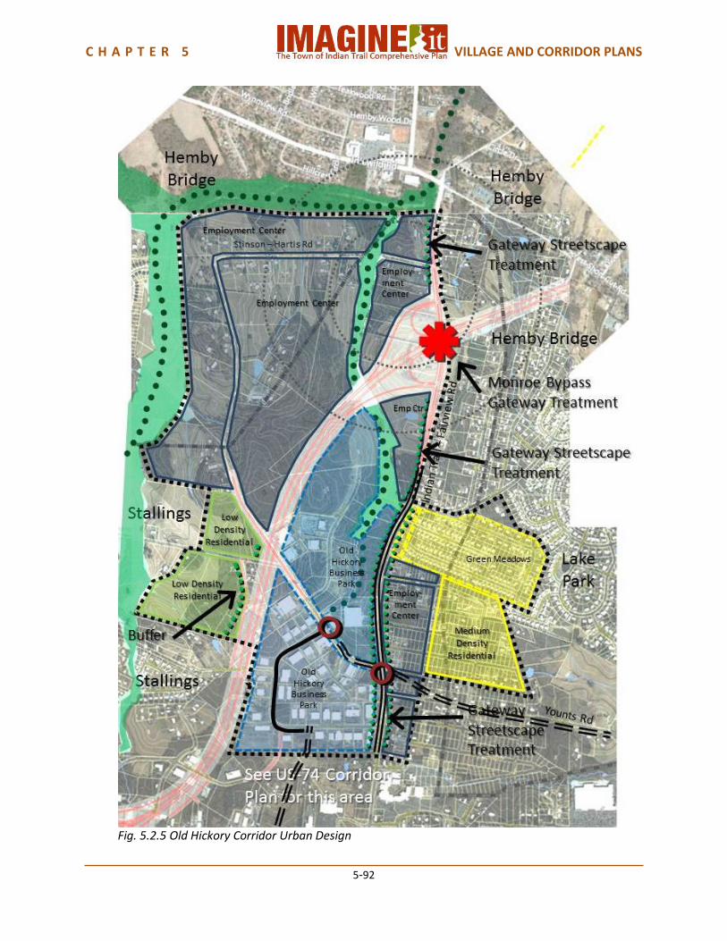
5.2.1 Old Hickory Corridor Plan The Old Hickory Corridor is located along Indian Trail-Fairview Road, at the north edge of town adjacent to the Town of Stallings and bounded by the Town of Hemby Bridge to the east. There will be a new Monroe Bypass interchange at Indian Trail-Fairview Road, giving the Old Hickory Corridor excellent regional access from both US-74 and the Bypass. This will create an opportunity to further build upon the success of the Old Hickory Business Park by establishing a Regional Employment Center. Land Use The existing non-residential land use in the Old Hickory Corridor consists of the Old Hickory Business Park between Indian Trail-Fairview Road and the new alignment of the Monroe Bypass. There are also individual, small commercial businesses located along the frontage of Indian Trail-Fairview Road. Residential land uses generally consist of a medium density residential subdivision at Green Meadows, some scattered single family residential in the Rosemary Park subdivision and larger lot low density residential along Stinson-Hartis Road west of the new Monroe Bypass alignment. The area along Stinson-Hartis Road west of the new Monroe Bypass alignment is planned as a Regional Employment Center to take advantage of the enhanced regional access that will be provided by the Bypass. Additional Regional Employment Center development is anticipated on the east side of Indian Trail-Fairview, between Green Meadows and First Baptist Church/Metrolina Christian Academy. Additional Suburban Mix residential development is provided for south of Green Meadows, and Rural Residential development south of Stinson-Hartis Road, which is reflective of the existing, low density residential development pattern in this area. Transportation There will be a new Monroe Bypass interchange connection to Indian Trail-Fairview Road. The Bypass construction will provide enlargement of Indian Trail-Fairview for approximately one-quarter mile south and north of the Interchange, and will have an overpass over Stinson-Hartis Road. Indian Trail-Fairview Road should become a 4 Lane Boulevard from the Bypass south. Chestnut Parkway, currently under construction west of US-74, is planned to continue to a connection with a new roundabout at Stinson-Hartis Road. A new roundabout may also be incorporated into the reconstructed intersection of Stinson-Hartis Road and Indian Trail-Fairview Road. Urban Design The Monroe Bypass interchange will create a significant gateway for Indian Trail. The Bypass has proposed a very high quality aesthetic design quality for its bridges and interchanges. This could be supplemented by the Town with landscaping and additional streetscape elements. Indian Trail-Fairview Road should receive a gateway streetscape treatment, with pedestrian scale lighting, banners, street trees, median plantings and street furnishings. A visual and noise buffer should be contemplated between the new Rural Residential development and the Monroe Bypass as part of future residential development.
C H A P T E R 5 VILLAGE AND CORRIDOR PLANS
5-88
Corridor Capacity The Old Hickory Corridor has an estimated population of approximately 550 people. The future land use plan provides for an additional capacity of approximately 1,450 people, for a total future capacity of approximately 2,500 people. The Old Hickory Corridor has an estimated current non-residential capacity of approximately 1.7 million square feet, which would support approximately 6,500 to 7,000 jobs. The future land use plan provides for an additional non-residential capacity of approximately 1.5 to 1.6 million square feet which would support approximately 6,000 to 6,500 additional jobs for a total future non-residential capacity of approximately 3.3 million square feet and approximately 13,000 jobs.
C H A P T E R 5 VILLAGE AND CORRIDOR PLANS
5-89
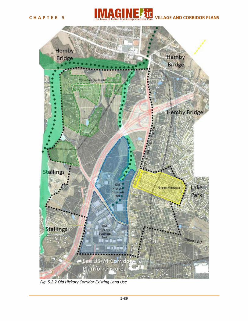
Fig. 5.2.2 Old Hickory Corridor Existing Land Use
C H A P T E R 5 VILLAGE AND CORRIDOR PLANS
5-90
Fig. 5.2.3 Old Hickory Corridor Future Land Use
C H A P T E R 5 VILLAGE AND CORRIDOR PLANS
5-91
Fig. 5.2.4 Old Hickory Corridor Transportation
C H A P T E R 5 VILLAGE AND CORRIDOR PLANS
5-92
Fig. 5.2.5 Old Hickory Corridor Urban Design

C H A P T E R 5 VILLAGE AND CORRIDOR PLANS
5-93
Fig. 5.2.6 Old Hickory Corridor Plan
C H A P T E R 5 VILLAGE AND CORRIDOR PLANS
5-94
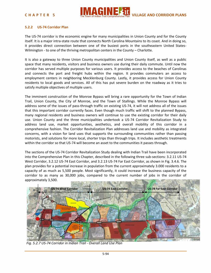
5.2.2 US-74 Corridor Plan The US-74 corridor is the economic engine for many municipalities in Union County and for the County itself. It is a major intra-state route that connects North Carolina Mountains to its coast. And in doing so, it provides direct connection between one of the busiest ports in the southeastern United States- Wilmington - to one of the thriving metropolitan centers in the County – Charlotte. It is also a gateway to three Union County municipalities and Union County itself, as well as a public space that many residents, visitors and business owners use during their daily commute. Until now the corridor has served multiple purposes for various users. It provides access to the beaches of Carolinas and connects the port and freight hubs within the region. It provides commuters an access to employment centers in neighboring Mecklenburg County. Lastly, it provides access for Union County residents to local goods and services. All of this has put severe burden on the roadway as it tries to satisfy multiple objectives of multiple users. The imminent construction of the Monroe Bypass will bring a rare opportunity for the Town of Indian Trail, Union County, the City of Monroe, and the Town of Stallings. While the Monroe Bypass will address some of the issues of pass-through traffic on existing US-74, it will not address all of the issues that this important corridor currently faces. Even though much traffic will shift to the planned Bypass, many regional residents and business owners will continue to use the existing corridor for their daily use. Union County and the three municipalities undertook a US-74 Corridor Revitalization Study to address land use, market opportunities, aesthetics, and overall mobility of this corridor in a comprehensive fashion. The Corridor Revitalization Plan addresses land use and mobility as integrated concerns, with a vision for land uses that supports the surrounding communities rather than passing motorists, and solutions for more local, shorter trips than through trips. It includes aesthetic treatments within the corridor so that US-74 will become an asset to the communities it passes through. The sections of the US-74 Corridor Revitalization Study dealing with Indian Trail have been incorporated into the Comprehensive Plan in this Chapter, described in the following three sub-sections: 3.2.11 US-74 West Corridor, 3.2.12 US-74 East Corridor, and 3.2.13 US-74 Far East Corridor, as shown in Fig. 3.4.6. The plan provides for a potential increase in population from the current approximately 3.000 residents to a capacity of as much as 5,500 people. Most significantly, it could increase the business capacity of the corridor to as many as 30,000 jobs, compared to the current number of jobs in the corridor of approximately 3,500. US-74 West Corridor US-74 East Corridor US-74 Far East Corridor
Fig. 5.2.7 US-74 Corridor in Indian Trail - Overall Land Use Plan
C H A P T E R 5 VILLAGE AND CORRIDOR PLANS
5-95
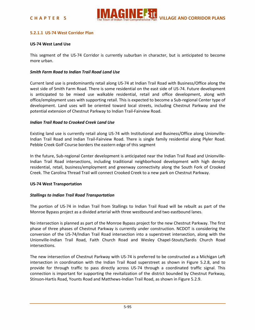
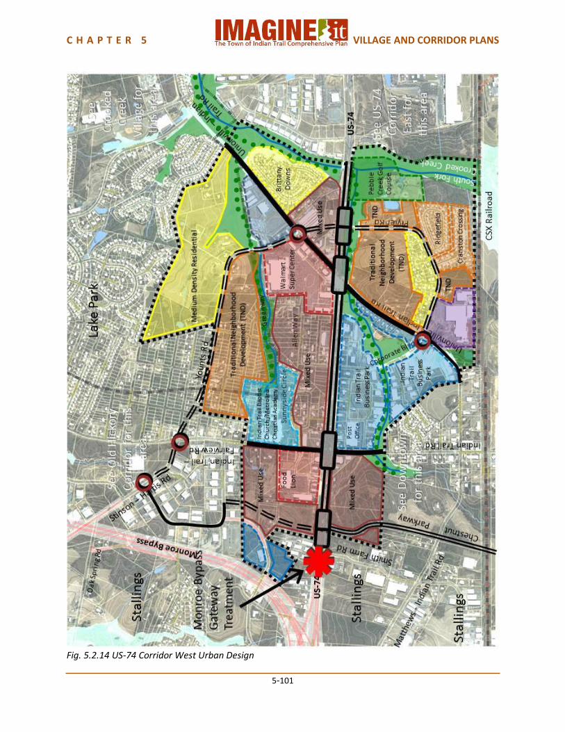
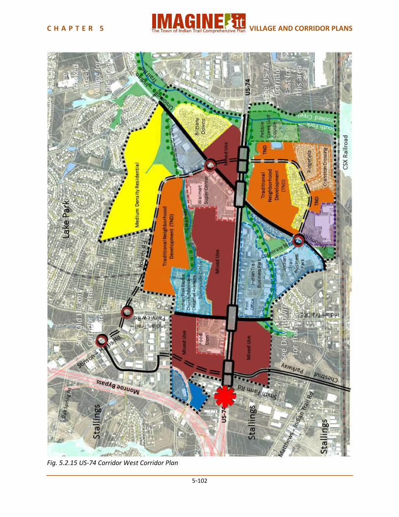
5.2.1.1 US-74 West Corridor Plan US-74 West Land Use This segment of the US-74 Corridor is currently suburban in character, but is anticipated to become more urban. Smith Farm Road to Indian Trail Road Land Use Current land use is predominantly retail along US-74 at Indian Trail Road with Business/Office along the west side of Smith Farm Road. There is some residential on the east side of US-74. Future development is anticipated to be mixed use walkable residential, retail and office development, along with office/employment uses with supporting retail. This is expected to become a Sub-regional Center type of development. Land uses will be oriented toward local streets, including Chestnut Parkway and the potential extension of Chestnut Parkway to Indian Trail-Fairview Road. Indian Trail Road to Crooked Creek Land Use Existing land use is currently retail along US-74 with Institutional and Business/Office along Unionville-Indian Trail Road and Indian Trail-Fairview Road. There is single family residential along Plyler Road. Pebble Creek Golf Course borders the eastern edge of this segment In the future, Sub-regional Center development is anticipated near the Indian Trail Road and Unionville-Indian Trail Road intersections, including traditional neighborhood development with high density residential, retail, business/employment and greenway connectivity along the South Fork of Crooked Creek. The Carolina Thread Trail will connect Crooked Creek to a new park on Chestnut Parkway. US-74 West Transportation Stallings to Indian Trail Road Transportation The portion of US-74 in Indian Trail from Stallings to Indian Trail Road will be rebuilt as part of the Monroe Bypass project as a divided arterial with three westbound and two eastbound lanes. No intersection is planned as part of the Monroe Bypass project for the new Chestnut Parkway. The first phase of three phases of Chestnut Parkway is currently under construction. NCDOT is considering the conversion of the US-74/Indian Trail Road intersection into a superstreet intersection, along with the Unionville-Indian Trail Road, Faith Church Road and Wesley Chapel-Stouts/Sardis Church Road intersections. The new intersection of Chestnut Parkway with US-74 is preferred to be constructed as a Michigan Left intersection in coordination with the Indian Trail Road superstreet as shown in Figure 5.2.8, and to provide for through traffic to pass directly across US-74 through a coordinated traffic signal. This connection is important for supporting the revitalization of the district bounded by Chestnut Parkway, Stinson-Hartis Road, Younts Road and Matthews-Indian Trail Road, as shown in Figure 5.2.9.
C H A P T E R 5 VILLAGE AND CORRIDOR PLANS
5-96
Fig. 5.2.8 Coordinated Superstreet and Michigan Left Fig. 5.2.9 Future district revitalization
intersections at Chestnut Parkway and area bounded by Chestnut Parkway, Indian Trail Road Stinson Hartis Road, Younts Road and
Matthews-Indian Trail Road Left turn only median breaks should be provided for access into the shopping center at the northeast corner of Indian Trail-Fairview Road and US-74, and those should also provide access into the potential development property adjacent to the planned Chestnut Parkway. The three existing driveways on the east side of the road should be closed and the parking lots be consolidated. There is also enough right-of-way to continue the provision of sidewalks consistent with the 6 Lane Boulevard typology (parts of which already exist). Indian Trail Road to Crooked Creek Transportation US-74 in this section, which is projected to have 60,000 Average Annual Daily Traffic by 2035, is to become a 6 Lane Boulevard typology. The Town of Indian Trail has been implementing the sidewalks for this typology as new development occurs. The Indian Trail Road, Unionville-Indian Trail Road, Faith Church Road and Wesley Chapel-Stouts/Sardis Church Road intersections with US-74 are currently being considered by NCDOT for conversion to superstreet intersections. The intersection of Plyler Road and US-74 has the potential to complete the Chestnut Parkway/Stinson-Hartis Road/Younts Road/Matthews-Indian Trail Road loop, which would help to stimulate redevelopment of this district in keeping with the Town’s Economic Development Plan The Unionville-Indian Trail Road superstreet intersection should be designed to allow for a future direct connection across US-74 from Plyler Road to a new link with Younts Road, as shown in Figure 5.2.9. Figure 5.2.10 suggests one way this might be accomplished.
C H A P T E R 5 VILLAGE AND CORRIDOR PLANS
5-97
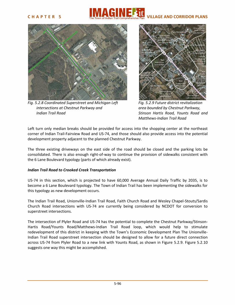
Fig. 5.2.10 Coordinated Superstreet and Michigan Left intersections at Unionville-Indian Trail Road and Plyler Road
The Corporate Boulevard intersection with US-74 would remain as an unsignalized intersection. Between Indian Trail Road and Unionville-Indian Trail Road driveways between Indian Trail Road and Corporate Boulevard should be consolidated to minimize curb cuts along US-74. An alternate access street – Post Office Street - already exists for additional access to these properties. Potential for a parallel street exists on the east side, linking Indian Trail Fairview Road to the Wal-Mart shopping center. Anticipated future redevelopment of the properties on the east side of US-74 will provide the opportunity to eliminate the existing driveways. US-74 West Urban Design Smith Farm Road to Indian Trail Road Urban Design Street trees, lighting, wayfinding signage and street furnishings on US-74 will create a boulevard road typology. Ornamental trees and ground cover in the median near intersections will help reinforce the Indian Trail identity. A gateway element at Chestnut Parkway/US-74 and Indian Trail-Fairview Road/Monroe Bypass Connector will create a sense of arrival into Indian Trail, and can celebrate the history of the Town and its family-oriented lifestyle. The new intersection of Chestnut Parkway with US-74 will be a community gateway for both Stallings and Indian Trail. Each community should have a distinct identity at this gateway, but the designs should be carefully coordinated. Indian Trail Road to Crooked Creek Urban Design Pedestrian lighting with banners at Indian Trail Road and the future Chestnut Parkway intersections will emphasize corridor aesthetics. Ornamental landscaping at Indian Trail Road and Chestnut Parkway intersection with street trees will also reinforce the corridor aesthetic. There should be wayfinding signage for destinations, such as Chestnut Square at Indian Trail, downtown Indian Trail, and other significant Indian Trail destinations. Building form and orientation should be toward the street to create pedestrian friendly environment with parking behind the buildings.
C H A P T E R 5 VILLAGE AND CORRIDOR PLANS
5-98
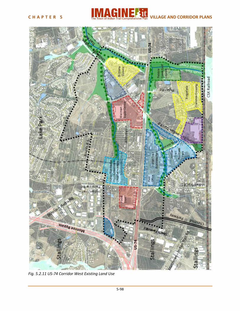
Fig. 5.2.11 US-74 Corridor West Existing Land Use
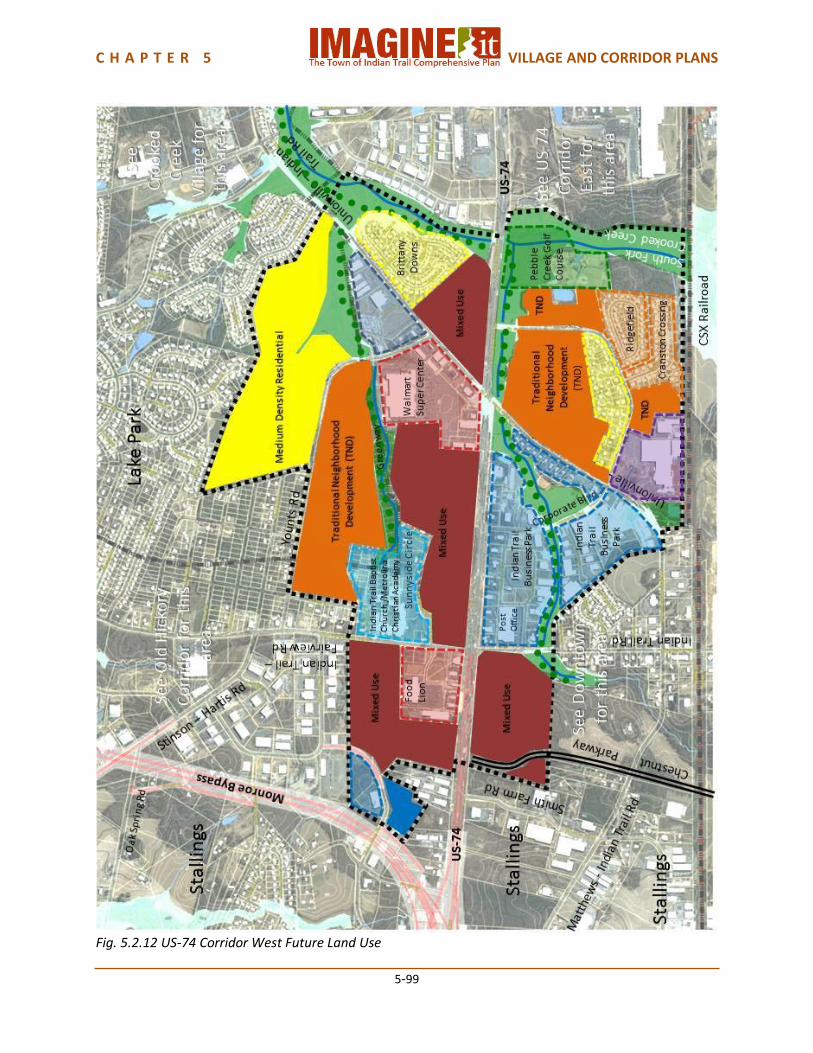
C H A P T E R 5 VILLAGE AND CORRIDOR PLANS
5-99
Fig. 5.2.12 US-74 Corridor West Future Land Use

C H A P T E R 5 VILLAGE AND CORRIDOR PLANS
5-100
Fig. 5.2.13 US-74 Corridor West Transportation
C H A P T E R 5 VILLAGE AND CORRIDOR PLANS
5-101
Fig. 5.2.14 US-74 Corridor West Urban Design
C H A P T E R 5 VILLAGE AND CORRIDOR PLANS
5-102
Fig. 5.2.15 US-74 Corridor West Corridor Plan

C H A P T E R 5 VILLAGE AND CORRIDOR PLANS
5-103
5.2.1.2 US-74 East Corridor Plan US-74 East Land Use Crooked Creek to Wesley Chapel-Stouts Road Land Use The current setting character is suburban/ industrial. Future mixed-use development on the west side of US-74 will change this setting to more suburban. The current land use in this segment is Commercial/Retail, Business Park, Industrial and Single Family Residential. Future land use will include Mixed Use, Business/Employment, and greenway Recreation along US-74. Wesley Chapel-Stouts Road to Laurel Creek Land Use The current setting is industrial. Future mixed use development on the west side of US-74 will change the setting to suburban. Current land use is Industrial and Business/Employment on the east side of US-74 and vacant on the west side. Future land use will remain Industrial and Business/Employment on the east side, with potential for substantial mixed use development on the west side of US-74. US-74 East Transportation Crooked Creek to Laurel Creek Transportation This section, which is anticipated to have 41,500 AADT by 2035, should become a 6 Lane Boulevard. The Town has been implementing the sidewalks for this typology as new development occurs. The Faith Church Road and Wesley Chapel-Stouts/Sardis Church Road intersections with US-74, along with Indian Trail Road and Unionville-Indian Trail Road, are currently being considered by NCDOT for conversion to superstreet intersections. The Sun Valley Place road that provides access to the Sun Valley Industrial Park will remain as a right-in/right-out intersection. There is an existing unsignalized intersection at Gray Fox Road that will remain. There is an existing “T” intersection at Helmsville Road that will eventually become a new signalized intersection when the land on the west side of US-74 eventually develops as an anticipated mixed use development. The existing left turn median break at Dale Jarrett Boulevard will remain. Between Crooked Creek and Faith Church Road, there will be a left turn access median break for access to the Indian Trail Industrial Park and a future mixed use development on the west side of US-74. This development and the Harris Teeter Distribution Center will have access from the planned Faith Church Road extension. Access to the office park at the northeast corner of US-74 and Faith Church Road will remain right-in/right-out only. This development also has access from Faith Church Road. Between Faith Church Road and Wesley Chapel-Stouts/Sardis Church Road, the existing Union Town Center access will remain right-in/right-out only from US-74. This development also has access from Faith Church Road. Southern Market Place currently has three right-in/right-out driveways. This

C H A P T E R 5 VILLAGE AND CORRIDOR PLANS
5-104
property is anticipated to eventually redevelop, at which time the driveways should be consolidated into a single access point. The Lowes store has existing right-in/right-out access that will remain, and the gas station/convenience store has two driveways that will remain. Both of these have access from Wesley Chapel-Stouts Road, and have interconnecting drives. A number of small properties on the east side of US-74 have individual driveways. These are anticipated to eventually redevelop, possibly as part of Sun Valley Industrial Park, at which time the access points should be limited to one or two right-in/right-out drives as well as connections to Sun Valley Place. The west side of US-74 in this section is anticipated to develop as a mixed use development. Access should be planned in conjunction with that development when it occurs to minimize conflicts with US-74 traffic. On the east side of US-74, development is relatively new and has been developed with right-in/right-out driveways which will remain. The vacant property at the northeast corner of US-74 and Helmsville Road is anticipated to eventually develop as industrial or business property, possibly in conjunction with the Indian Trail Industrial Park. When that occurs, access directly onto US-74 should be minimized, with more access provided from Gray Fox Road. The Crossroads Ford and Kia dealerships have relatively new right-in/right-out driveways as well as access from Dale Jarrett Boulevard and Helmsville Road. These will remain. Three smaller car dealerships and repair shops east of Helmsville Road currently have two separate right-in/right-out driveways. Consolidation of these drives and access from Helmsville Road would be desirable. US-74 East Urban Design Crooked Creek to Wesley Chapel-Stouts Road Urban Design Pedestrian lighting with banners at Unionville-Indian Trail Road, ornamental landscaping at Unionville-Indian Trail Road and Wesley Chapel-Stouts Road intersections and street trees along US-74 will reinforce the linear corridor aesthetic. There should be wayfinding directional signage for destinations such as the movie theatre, Sun Valley High School, etc. Building form and orientation for future mixed use development on the west side of US-74 should be toward the street to create pedestrian friendly environment with parking behind the buildings. Wesley Chapel-Stouts Road to Laurel Creek Urban Design Pedestrian lighting with banners at Unionville-Indian Trail Road, ornamental landscaping at Unionville-Indian Trail Road and Wesley Chapel-Stouts Road intersections and street trees along US-74 will reinforce the linear corridor aesthetic. Building form and orientation for future mixed use development on the west side of US-74 should be toward the street to create pedestrian friendly environment with parking behind the buildings. Laurel Creek’s greenway open space offers an excellent location for an Indian Trail community gateway, enhancing the greenway with monumentation and identity signage. Since this will also be a community gateway for Monroe, each community should have a distinct identity at this gateway, but the designs should be carefully coordinated.
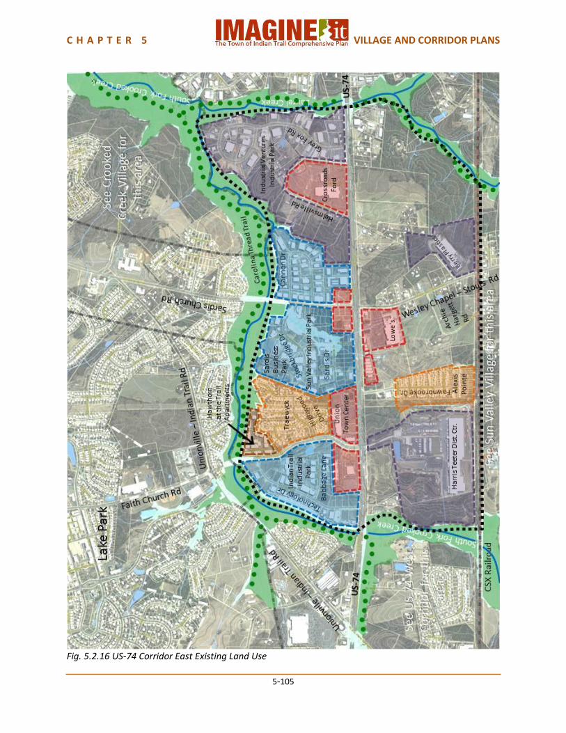
C H A P T E R 5 VILLAGE AND CORRIDOR PLANS
5-105
Fig. 5.2.16 US-74 Corridor East Existing Land Use
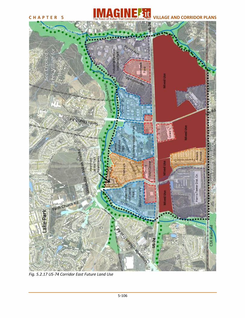
C H A P T E R 5 VILLAGE AND CORRIDOR PLANS
5-106
Fig. 5.2.17 US-74 Corridor East Future Land Use
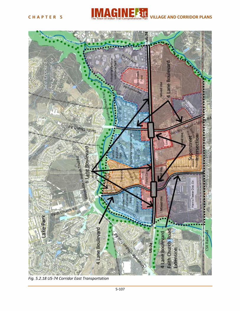
C H A P T E R 5 VILLAGE AND CORRIDOR PLANS
5-107
Fig. 5.2.18 US-74 Corridor East Transportation
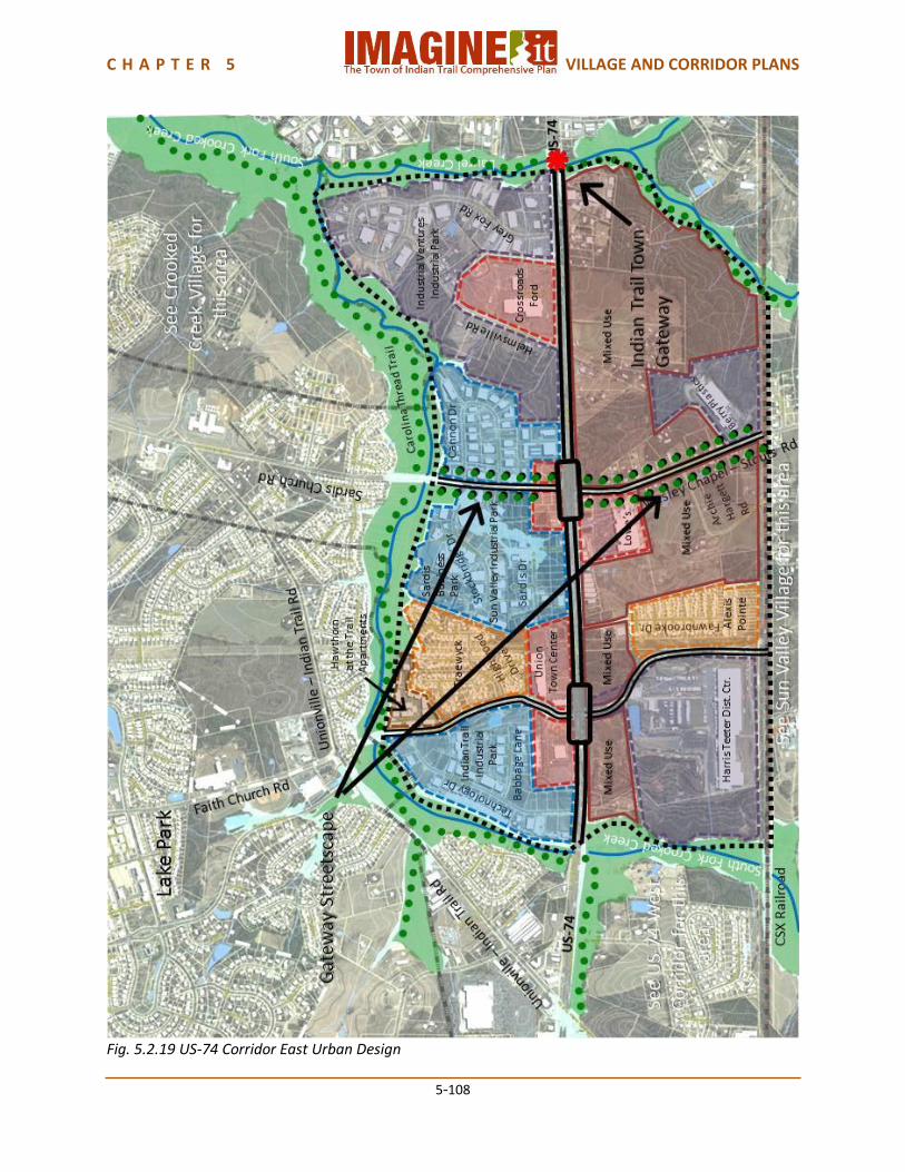
C H A P T E R 5 VILLAGE AND CORRIDOR PLANS
5-108
Fig. 5.2.19 US-74 Corridor East Urban Design

C H A P T E R 5 VILLAGE AND CORRIDOR PLANS
5-109
Fig. 5.2.20 US-74 Corridor East Corridor Plan
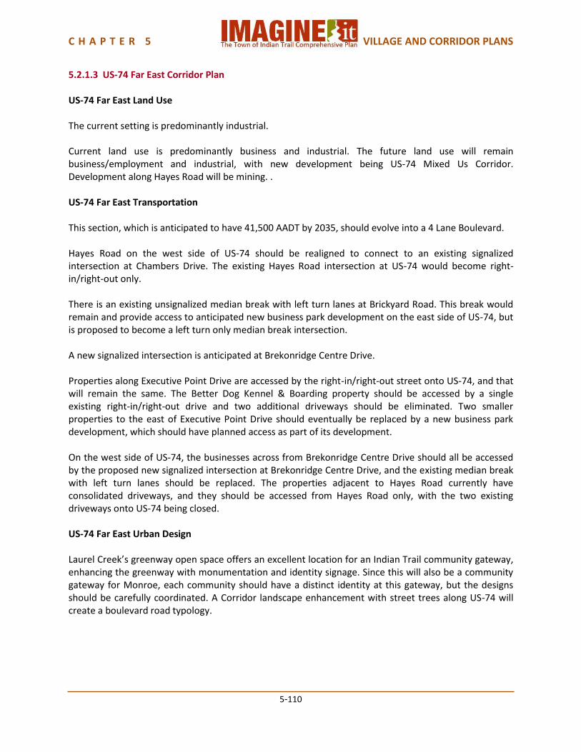
C H A P T E R 5 VILLAGE AND CORRIDOR PLANS
5-110
5.2.1.3 US-74 Far East Corridor Plan US-74 Far East Land Use The current setting is predominantly industrial. Current land use is predominantly business and industrial. The future land use will remain business/employment and industrial, with new development being US-74 Mixed Us Corridor. Development along Hayes Road will be mining. . US-74 Far East Transportation This section, which is anticipated to have 41,500 AADT by 2035, should evolve into a 4 Lane Boulevard. Hayes Road on the west side of US-74 should be realigned to connect to an existing signalized intersection at Chambers Drive. The existing Hayes Road intersection at US-74 would become right-in/right-out only. There is an existing unsignalized median break with left turn lanes at Brickyard Road. This break would remain and provide access to anticipated new business park development on the east side of US-74, but is proposed to become a left turn only median break intersection. A new signalized intersection is anticipated at Brekonridge Centre Drive. Properties along Executive Point Drive are accessed by the right-in/right-out street onto US-74, and that will remain the same. The Better Dog Kennel & Boarding property should be accessed by a single existing right-in/right-out drive and two additional driveways should be eliminated. Two smaller properties to the east of Executive Point Drive should eventually be replaced by a new business park development, which should have planned access as part of its development. On the west side of US-74, the businesses across from Brekonridge Centre Drive should all be accessed by the proposed new signalized intersection at Brekonridge Centre Drive, and the existing median break with left turn lanes should be replaced. The properties adjacent to Hayes Road currently have consolidated driveways, and they should be accessed from Hayes Road only, with the two existing driveways onto US-74 being closed. US-74 Far East Urban Design Laurel Creek’s greenway open space offers an excellent location for an Indian Trail community gateway, enhancing the greenway with monumentation and identity signage. Since this will also be a community gateway for Monroe, each community should have a distinct identity at this gateway, but the designs should be carefully coordinated. A Corridor landscape enhancement with street trees along US-74 will create a boulevard road typology.
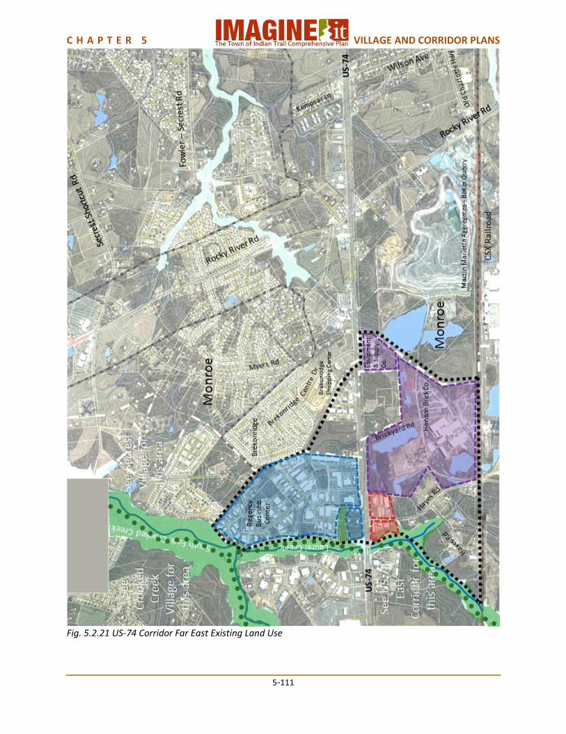
C H A P T E R 5 VILLAGE AND CORRIDOR PLANS
5-111
Fig. 5.2.21 US-74 Corridor Far East Existing Land Use

C H A P T E R 5 VILLAGE AND CORRIDOR PLANS
5-112
Fig. 5.2.22 US-74 Corridor Far East Future Land Use
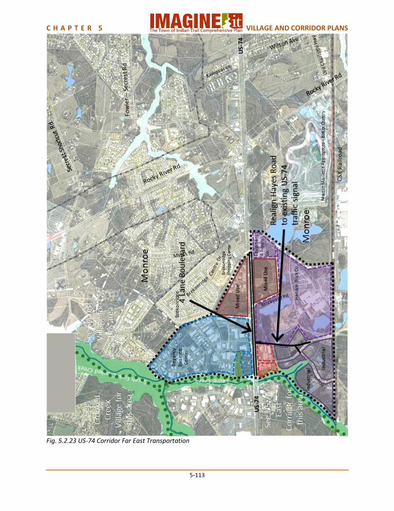
C H A P T E R 5 VILLAGE AND CORRIDOR PLANS
5-113
Fig. 5.2.23 US-74 Corridor Far East Transportation

C H A P T E R 5 VILLAGE AND CORRIDOR PLANS
5-114
Fig. 5.2.24 US-74 Corridor Far East Urban Design
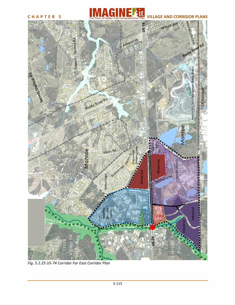
C H A P T E R 5 VILLAGE AND CORRIDOR PLANS
5-115
Fig. 5.2.25 US-74 Corridor Far East Corridor Plan
C H A P T E R 5 VILLAGE AND CORRIDOR PLANS
5-116
5.3 DOWNTOWN INDIAN TRAIL PLAN The Indian Trail Town Council adopted the Downtown Master Plan in 2006. Changes since the plan was adopted include opening Town Government offices and Crossing Paths Park on Blythe Drive, beginning construction of the 51 acre Chestnut Square at Indian Trail park, and beginning construction of Chestnut Parkway. This update adds some land area to the plan, but it otherwise remains virtually the same. Indian Trail has a rich and diverse history that should be honored as the downtown continues to evolve into the primary identity for the community. The Downtown Master Plan is intended to provide the basis for creating a vibrant downtown which promotes a diversity of uses and users, while promoting opportunities to live, work and play in the vision of its citizens. The Downtown Master Plan serves to show, through descriptions and photographic examples how to create a lively and attractive downtown. It is the responsibility of property and business owners, developers, elected officials and citizens to use the Downtown Master Plan’s Design Guidelines to help guide appropriate development for Indian Trail. Changes that have occurred since the adoption of the Downtown Master Plan include:
Town offices have expanded to include a new Cultural Arts Center within the old Town Hall
Consolidation of departments within the Administrative Services Building located on Blythe Drive
Development of a new one-acre event park – Crossing Paths Park on Blythe Drive, located adjacent to the Administrative Building
Development of a new 51 acre park, still under development, located on Matthews-Indian Trail Road, - Chestnut Square at Indian Trail. This park is a model for public-private partnerships with the relocation of Carolina Courts as an anchor within the park. Carolina Courts is a private indoor recreation facility that will bring tens of thousands of guests to Downtown Indian Trail
Construction of the first segment of Chestnut Parkway between Matthews-Indian Trail Rd. & US-74
Expansion of the Downtown boundaries to include single family residential areas along South Fork Road and light industry areas along Gribble Road and Matthews-Indian Trail Road
Land Use Downtown Indian Trail land use along Indian Trail Road is a mix of older commercial, institutional and residential uses. Notable landmarks include the historic Indian Trail Presbyterian Church, Indian Trail Elementary School and Indian Trail United Methodist Church. The older Town Administrative offices have been converted to an Indian Trail Cultural Center. Along Unionville-Indian Trail Road is a mix of commercial, light industrial and institutional uses, including the Indian Trail Library. The neighborhood to the northwest of Indian Trail Road consists of older single family detached homes. Along South Fork Road are neighborhoods of single family detached residences. The privately owned Edna Love Park and a Town maintained cemetery are on Park Road. A large tract of vacant land, previously approved as a town center mixed use development, is along the CSX Railroad tracks. North of the new Chestnut Parkway along Matthews-Indian Trail Road and Gribble Road is light industry. Future land uses can vary within the Downtown to include new office, suburban residential, office and mixed use through redevelopment opportunities. A diverse range of residential housing types should be provided to promote a population with varied ages, races and socioeconomic background. Flexibility also needs to be provided to meet economic changes and to allow incremental growth. Future land use
C H A P T E R 5 VILLAGE AND CORRIDOR PLANS
5-117
will include Suburban Residential development along Chestnut Parkway west of the CSX Railroad and along South Fork Road. The former town offices site and its surrounding neighborhood should redevelop into a walkable mixed use neighborhood. Undeveloped property elsewhere should develop as walkable mixed use developments, and much of the existing mixed use area might do the same. New office development will be appropriate on the north side of Chestnut Parkway. The Downtown Village should support limited light industrial land uses at appropriate locations based on their proximity to CSX railroad, adjoining land uses, and property location within the village. Existing Heavy Industrial land uses are located north of the future Chestnut Connector. Transportation Indian Trail Road through Downtown, Unionville-Indian Trail Road through Downtown southeast of Chestnut Square at Indian Trail, and Park Road should become 2 Lane Main Streets, with on-street parking and pedestrian sidewalks. Park Road should be extended to connect to Gribble Road. The posted speed limit on these streets should be low enough to allow bicycles to operate in mixed traffic. Matthews-Indian Trail Road through Chestnut Square at Indian Trail and Gribble Road should become 2 Lane Thoroughfares by adding bicycle lanes and pedestrian sidewalks with street trees. Chestnut Parkway, currently under construction, will be a 4 Lane Boulevard which will eventually connect to the Old Hickory Corridor as part of the Town’s Pathways-To-Progress initiative. Local streets throughout Downtown should be interconnected as described in the Downtown Master Plan. The location, accessibility and proper visibility of parking lots are critical to creating an attractive downtown. Downtowns should be designed for the pedestrian while accommodating parked cars, not the reverse. On-street parallel parking should be designed along the commercial street frontage to deter high speed traffic, buffer pedestrian activity on the sidewalk and promote convenience parking opportunities in front of commercial establishments. Streets are a significant component of the public space and play a major role in establishing the image of a community. They affect the health, vitality, quality of life, and economic welfare of the downtown as they set the framework for development. The design of a street is only one aspect of its effectiveness. How the street relates to the surrounding transportation network, land use system, and urban/ neighborhood fabric is also crucial to its effectiveness. The Downtown should be designed for the pedestrian and should promote a vital active environment. Uses on the ground floor should promote opportunities for social interaction, shopping, eating and lounging. The area should be pleasing and safe to walk and provide a comfortable experience for the users. Urban Design The architectural style, scale and character of new and existing buildings will define the downtown and should promote a pedestrian friendly environment that represents the vision of its citizens. The physical relationship of buildings to the public street and its uses should reinforce the pedestrian scale. To promote a pedestrian-oriented environment in Indian Trail, it is important to maintain consistent and
C H A P T E R 5 VILLAGE AND CORRIDOR PLANS
5-118
active storefronts. The public street should be the primary place for community interaction that invites pedestrians to use the downtown as a destination to live, to work, to play and to socialize. The Downtown should promote a sense of community through the design and construction of a variety of parks, plazas and open spaces. These areas should be designed for safety, comfort, beauty and social gatherings and should become places of community activity, as well as neighborhood identity. Both active and passive areas should be design to engage citizens and offer different programmatic uses. Neighborhood squares, parks, playgrounds and green spaces are for the use, benefit, and enjoyment of the entire community. These are places where communities can gather for celebrations, families and friends gather for picnics or socializing, and individuals can find solitude. These spaces become the defining places where the community comes to know one another. Downtown Indian Trail Capacity Downtown Indian Trail has an estimated current population of approximately 450 people. The future land use plan provides for an additional capacity of approximately 1,550 people, for a total future capacity of approximately 2,000 people.
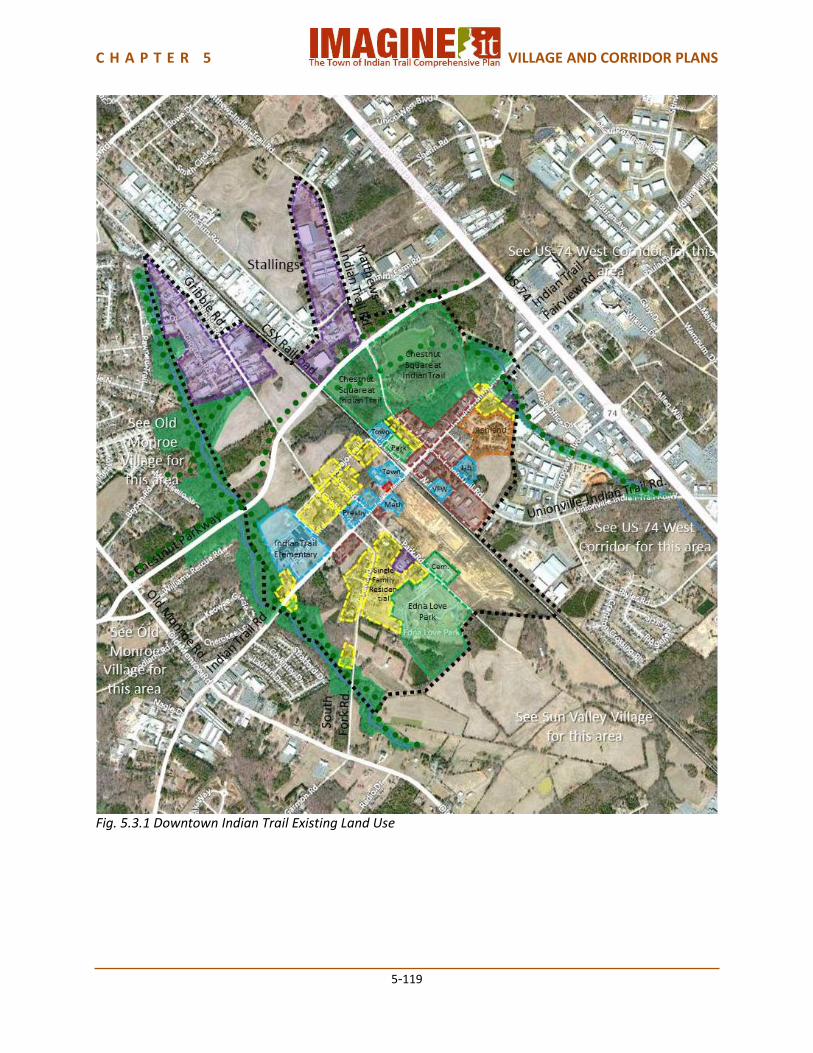
C H A P T E R 5 VILLAGE AND CORRIDOR PLANS
5-119
Fig. 5.3.1 Downtown Indian Trail Existing Land Use
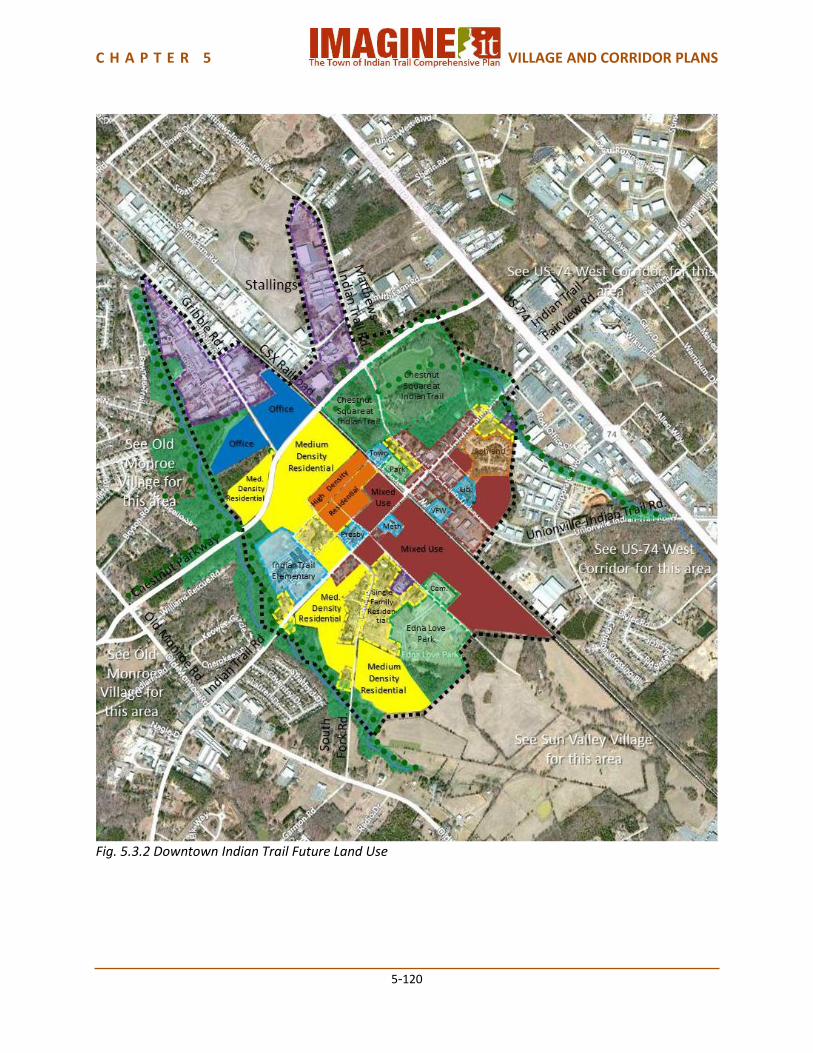
C H A P T E R 5 VILLAGE AND CORRIDOR PLANS
5-120
Fig. 5.3.2 Downtown Indian Trail Future Land Use
C H A P T E R 5 VILLAGE AND CORRIDOR PLANS
5-121
Fig. 5.3.3 Downtown Indian Trail Transportation
C H A P T E R 5 VILLAGE AND CORRIDOR PLANS
5-122
Fig. 5.3.4 Downtown Indian Trail Urban Design as depicted in the adopted Downtown Indian Trail Master Plan. Urban Design is described in more detail in the Downtown Indian Trail Master Plan.

C H A P T E R 5 VILLAGE AND CORRIDOR PLANS
5-123
Fig. 5.3.5 Downtown Indian Trail Plan