
It’s a flyway, a highway, and the mightiest waterway in...
6
By Mary Hoff It’s a flyway, a highway, and the mightiest waterway in the land. I could hardly believe my eyes. Growing up in a small town in north- eastern Wisconsin, I had heard so much about the mighty Mississippi River. It traced a fat, blue path down the middle of the U.S. map that hung on the wall of my third-grade classroom, forming part of the border between my state and its “Out West” neighbors, Minnesota and Iowa. Indians and French explorers paddled the Mississippi through the pages of my history book. Reading The Adventures of Huckleberry Finn, I imagined floating on a rough-hewn raft in its muddy water. Then suddenly there I was, on the second day of a car trip to Colorado with my dad and my brother, standing on its bank. I watched as the dark, wide water flowed by, awestruck because the river appeared immense to me. Then I did what any 12-year-old would do: I picked up a rock and chucked it in. A M o s t A m a z i n g R i v e r Clockwise from top left: Visitors enjoy the headwaters of the Mississippi River at Lake Itasca. Downstream from Lake Itasca, the Mississippi resembles a creek on its way to Lake Bemidji. An 1870 sketch depicts the Northern Pacific Railroad bridge where it crosses the Mississippi in Brainerd. A team oars a sleek rowing shell on the Mississippi near St. Paul. Pelicans gather on a sandbar. A tugboat prepares to move barges on the Mississippi at St. Paul. 28 LEFT HAND PAGE: TOP LEFT, RIGHT, BOTTOM RIGHT; RICHARD HAMILTON SMITH, BOTTOM LEFT; STAN TEKIELA, RIGHT HAND PAGE: TOP; MINNESOTA HISTORICAL SOCIETY, BOTTOM; RICHARD HAMILTON SMITH
-
Upload
truongnhan -
Category
Documents
-
view
228 -
download
0
Transcript of It’s a flyway, a highway, and the mightiest waterway in...

By Mary Hoff
It’s a flyway, a highway, and the
mightiest waterway in the land.
I could hardly believe my eyes. Growing up in a small town in north-eastern Wisconsin, I had heard so much about the mighty Mississippi River. It traced a fat, blue path down the middle of the U.S. map that hung on the wall of my third-grade classroom, forming part of the border between my state and its “Out West” neighbors, Minnesota and Iowa.
Indians and French explorers paddled the Mississippi through the pages of my history book. Reading The Adventures of Huckleberry Finn, I imagined floating on a rough-hewn raft in its muddy water.
Then suddenly there I was, on the second day of a car trip to Colorado with my dad and my brother, standing on its bank. I watched as the dark, wide water flowed by, awestruck because the river appeared immense to me.
Then I did what any 12-year-old would do: I picked up a rock and chucked it in.
A Most Amazing River
Clockwise from top left: Visitors enjoy the headwaters of the Mississippi River at Lake Itasca. Downstream from Lake Itasca, the Mississippi resembles a creek on its way to Lake Bemidji. An 1870 sketch depicts the Northern Pacific Railroad bridge where it crosses the Mississippi in Brainerd. A team oars a sleek rowing shell on the Mississippi near St. Paul. Pelicans gather on a sandbar. A tugboat prepares to move barges on the Mississippi at St. Paul.
28 Left Hand Page: toP Left, RigHt, Bottom RigHt; RicHaRd HamiLton SmitH, Bottom Left; Stan tekieLa, RigHt Hand Page: toP; minneSota HiStoRicaL Society, Bottom; RicHaRd HamiLton SmitH

30 Minnesota Conservation Volunteer July–August 2008 31
Our Nation’s RiverLike the midline on the playing field of our nation, the Mississippi River divides the United States into two parts. Ten states use it as part of their border. Places are often identified as being “east of the Mississippi” or “west of the Mississippi.” At one time settlers saw the river as the edge between civilization and the wilderness.
Long, strong, hard-working, and histo-ry-filled, the Mississippi is North America’s most amazing river. Many people go a life-time without ever getting a look at it. But not around here! Most Minnesotans live within an hour’s drive of the Mississippi.
More than 1 million Minnesotans get their drinking water from the big river. Each year thousands of boats, big and small, travel its waters for work or for fun. Anglers and commercial fishermen pull tons of fat fish from its waters. The Mississippi River is a big part of life in Minnesota.
Ol’ Man RiverSome people call the Mississippi “Old Man River.” It is old on a human scale—but not on a geological one. The Mississippi River north of the Twin Cities was formed by water gushing from giant glaciers just 12,000 years ago. As the water rushed downhill, it carved pathways through the gravel and sediment left behind by the melting glaciers. These pathways became the river channel.
Between St. Paul, where the Minnesota River joins it, and the Iowa border, the Mississippi River has cut down to bedrock that is millions of years old. As our part of the world went through glacial episodes, the valley periodically filled with sand and gravel carried by the river, then was carved out by floods of water from melting glacial ice.
About how long is the Mississippi River?a. 400 miles, b. 1,000 miles, c. 2,300 miles, d. 5,900 miles (answer page 39)
The sun rises over the Upper Mississippi River National Wildlife Refuge near Whitman in southeastern Minnesota.
MINNESOTA
IOWA
MISSOURI
ARKANSAS
LOUISIANA
TENNESSEE
KENTUCKY
ILL INOIS
WISCONSIN
MISSISSIPP I
MINNESOTA
IOWA
MISSOURI
ARKANSAS
LOUISIANA
MISSISSIPP I
TENNESSEE
KENTUCKY
ILL INOIS
WISCONSIN
Left
Pag
e: R
icH
aRd
Ham
iLto
n S
mit
H, R
igH
t Pa
ge;
mat
t ka
nia
1
32 Minnesota Conservation Volunteer
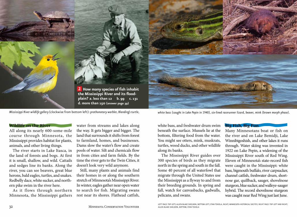
Wildlife on the RiverAll along its nearly 600-some-mile course through Minnesota, the Mississippi provides habitat for plants, animals, and other living things.
The river starts in Lake Itasca, in the land of forests and bogs. At first it is small, shallow, and wild. Cattails and sedges line its banks. Along the river, you can see beavers, great blue herons, bald eagles, turtles, and snakes. Redbelly dace, white sucker, and north-ern pike swim in the river here.
As it f lows through northern Minnesota, the Mississippi gathers
water from streams and lakes along the way. It gets bigger and bigger. The land that surrounds it shifts from forest to farmland, homes, and businesses. Dams slow the water’s flow and create pools of water. Silt and chemicals flow in from cities and farm fields. By the time the river gets to the Twin Cities, it doesn’t look very wild anymore.
Still, many plants and animals find their homes in or along the southern stretch of Minnesota’s Mississippi River. In winter, eagles gather near open water to search for fish. Migrating swans rest near its shores. Flathead catfish,
white bass, and freshwater drum swim beneath the surface. Mussels lie at the bottom, filtering food from the water. You might see otters, mink, muskrats, turtles, wood ducks, and other wildlife along its banks.
The Mississippi River guides over 300 species of birds as they migrate north in the spring and south in the fall. Some 40 percent of all waterfowl that migrate through the United States use the Mississippi as a flyway to and from their breeding grounds. In spring and fall, watch for canvasbacks, gadwalls, pelicans, and swans.
Big Fish, Big FunMany Minnesotans boat or fish on the river and on Lake Bemidji, Lake Winnibigoshish, and other lakes it runs through. Water skiing was invented in 1922 on Lake Pepin, a widening of the Mississippi River south of Red Wing. Eleven of Minnesota’s state-record fish were caught in the Mississippi: white bass, bigmouth buffalo, river carpsucker, channel catfish, freshwater drum, short-nose gar, quillback, sauger, shovelnose sturgeon, blue sucker, and walleye-sauger hybrid. The record shovelnose sturgeon was caught near Red Wing just last June.
How many species of fish inhabit the Mississippi River and its flood-plain? a. less than 12 b. 99 c. 131 d. more than 150 (answer page 39)
Mississippi River wildlife gallery (clockwise from bottom left): prothonotary warbler, Blanding’s turtle, white bass (caught in Lake Pepin in 1940), six-lined racerunner lizard, beaver, mink (brown morph phase).
Left Page: toP Left; aLLen BLake SHeLdon, Bottom Left; Stan tekieLa, RigHt; minneSota HiStoRicaL Socitey, RigHt Page: toP Left and RigHt; aLLen BLake SHeLdon, Bottom; Stan tekieLa
2

34 Minnesota Conservation Volunteer July–August 2008 35
Misi-ziibi of the Indian PeopleThe name Mississippi comes from the Ojibwe Misi-ziibi, meaning “Great River.” Before European settlers arrived in what we now call Minnesota, the Indian people were the main inhabitants of the banks of the Mississippi. They used the water for drinking, cooking, and washing. They speared fish and harvested mussels from the river. They paddled canoes upstream and down to find food and fight battles. They used clay from the river to paint their canoes and baskets.
Explorers, Lumberjacks, SettlersFollowing Marquette and Joliet’s Mississippi River voyage in 1673, other European
explorers began to use the Mississippi as a pathway into the wilderness. They found vast pine forests in its upper reaches in north-central Minnesota.
When lumberjacks began cutting the trees in northern Minnesota in the mid-1800s, the upper Mississippi car-ried logs downstream to sawmills in Minneapolis. The mills cut them into boards to be used to build homes, stores, and other buildings for the people set-tling in Minneapolis, St. Paul, and other cities along the Mississippi River.
In 1823 the steamboat Virginia brought travelers from St. Louis, Missouri, up the river to St. Paul for the first time. In 1854 a railroad connected the Mississippi
River in Illinois with cities in the east-ern United States, and the rush was on! With the river as a highway from Illinois north, many settlers were able to come to Minnesota to begin a new life, enough to have Minnesota declared a state in 1858.
Barges and DamsAll those settlers in Minnesota produced many things, such as wheat and other farm products, flour, lumber, cloth, and yarn. The Mississippi was the highway they used to ship their products to market downriver. Tools, furniture, cotton, and other necessities were shipped up the river to Minnesota’s fast-growing cities and towns.
In the late 1800s, the federal govern-ment began installing wing dams to channel or hold back water along the Mississippi River. The dams made the water deeper, so large boats didn’t hit the bottom when they carried their loads up and down the river. In the early 1900s, the U.S. Army Corps of Engineers began building a series of dams with locks (elevatorlike passages to let boats through) to make it even better traveling for even bigger boats.
Today the Minnesota stretch of the Mississippi River has 11 locks and dams. Barges haul millions of tons of coal, wheat, gravel, petroleum, cement, and other goods up and down the river each year.
About how long does it take a raindrop to travel from Lake Itasca to the Gulf of Mexico? a. 90 hours b. 90 days c. 90 weeks d. 90 years (answer page 39)
This 1845 painting depicts a Dakota village alongside the Mississippi River in southeastern Minnesota. Thousands of immigrants came to Minnesota on steamboats, such as the Favorite, moored at Winona in 1861.
3
min
neS
ota
HiS
toRi
caL
Soci
ety

36 Minnesota Conservation Volunteer July–August 2008 37
Water PowerIn the 1800s people built sawmills and flour mills alongside the river. To run the machines that cut wood into boards or ground grain into flour, the mills used the power from rushing water at St. Anthony Falls, the only major waterfall on the Mississippi.
Today those mills are gone, but 10 hydroelectric power plants use the ener-gy in the running water of Minnesota’s Mississippi River to turn huge turbines that produce electrical current. This elec-tricity keeps light bulbs, furnaces, air conditioners, computers, and cell-phone chargers working. Coal-fired and nuclear power plants also generate electricity along the river and use the river’s water for cooling their steam generators.
Tap and DrainIf you live in St. Cloud, Minneapolis, or St. Paul, you can turn on a tap in your house and see Mississippi water. These cities draw water from the river, clean it, and send it through pipes to homes for drinking, cooking, and washing.
The river also serves as a place to send water. Every Minnesota city along the Mississippi River from Bemidji to the Iowa border sends treated wastewater from toilets, sinks, and tubs out into the river. Drains on city streets channel storm water into the river. Water from farmland runs into streams that run into the river. The Mississippi drains more land than any other river in the nation. Along with water, the river carries about 436,000 tons of sand and soil downstream per day.
Puzzling ProblemsWith so many uses and so many people living on the land that drains into it, the Mississippi has had some hard times staying healthy.
Dams disrupt the travels of fish and other water creatures. Dams also prevent the seasonal fall of water to its natural low level. This has made it hard for plants that need exposure to air and light to sprout and grow along the shallows. This in turn makes the river less inviting to shorebirds, ducks, and other animals that otherwise might thrive along its banks.
Nonnative species such as carp and zebra mussels have gotten into the river. These animals are called invasive because they invade the habitat. They compete with native species for food and space. Carp
muddy the water by stirring up the bottom as they search for food. Invasive species make it harder for native species to thrive.
From the early 20th century until the 1970s, the section of the Mississippi River that flows through Minneapolis and St. Paul was so polluted few animals could live there. Encouraged by the Clean Water Act of 1972 and other laws, local, regional, state, and federal governments worked together to reduce pollution.
Today peregrine falcons hunt the river’s banks. Bass, pike, and other wild fish swim right through the Twin Cities. Endangered Higgins eye pearly mussels are starting to thrive again in the Mississippi. The Mississippi is healthier than it has been in a long time, but growing cities continue to threaten the health of the river.
What is the longest river in the United States?a. Amazon b. Mississippi c. Missouri d. Rio Grande (answer, page 39)
In this 1937 photo, a steam engine pulls rail cars across the Stone Arch Bridge in Minneapolis. The milling district can be seen in the background.
Today barges are able to pass St. Anthony Falls and under the Stone Arch Bridge via the lock and dam, which can be seen on the left. Upstream, the Central Avenue bridge is visible.
4
Left
Pag
e; m
inn
eSo
ta H
iSto
Rica
L So
ciet
y, R
igH
t Pa
ge;
Ric
HaR
d H
amiL
ton
Sm
itH

38 Minnesota Conservation Volunteer
Skipping Down the River Did you ever try to skip a stone in the water? You can skip your way down the Mississippi River by stopping at each of the nine state parks found along the way.
The Mississippi starts at Lake Itasca in Itasca State Park. The head (beginning) of the river used to be a swamp. In the early 1900s, workers changed the path so it would flow as a clear stream. Then they added rocks so visitors could walk across it.
The Mississippi River f lows diagonally through Lake Bemidji.
At Lake Bemidji State Park, you can sometimes take a naturalist-led pontoon tour of the lake and see the Mississippi.
Henry Rowe Schoolcraft, the first white man to find the source of the Mississippi, once camped in the vicinity of what is now Schoolcraft State Park. You can camp here and maybe catch a fish from the Mississippi River for breakfast too.
Crow Wing State Park marks the spot where the Red River oxcart trail, a 19th-century “highway” for fur trad-ers, crossed the Mississippi. Watch for blue-winged teal, pied-billed grebes,
and double-crested cormorants as you hike the riverside trail.
The first person to cross the Atlantic Ocean nonstop in an airplane, Charles Lindbergh, grew up on the banks of the Mississippi at what is now Charles A. Lindbergh State Park. You can visit his house, a historic site, and imagine how living here helped make Lindbergh an adventurer!
The Mississippi and Minnesota rivers merge at Fort Snelling State Park in St. Paul. Instead of the thick bogs and tall pines of the north, the river is lined here with marshes and cottonwood, silver maple, and willow trees.
Long before European settlers arrived, Indian people fished from the Mississippi in the place we now call Frontenac State Park near Red Wing. The river widens here into Lake Pepin. Watch for eagles as you hike or picnic.
Early riverboat captains used three bluffs they called Faith, Hope, and Charity as landmarks as they navigated the stretch of the Mississippi River near what is now John A. Latsch State Park. You can take a half-mile trail to the top of Mount Charity for a “big-picture” look at the river.
Long ago American Indians built burial and effigy mounds in what is now Great River Bluffs State Park. Unusual habitats here include tree-less, thin-soiled bluffland called goat prairie and a stand of northern white cedar. Hike up high and wave to the Mississippi River as it continues on its way south to the Gulf of Mexico. nV
More about the MississippiVisit www.nps.gov/miss/index.htm to learn
about the Mississippi National River and
Recreation Area, a 72-mile stretch of the
Mississippi from Dayton to Hastings. The
park’s headquarters are located in downtown
St. Paul.
Check out these books about the Mississippi River!The Song of Hiawatha, by Henry Wadsworth
Longfellow
The Adventures of Huckleberry Finn, by Mark Twain
Minn of the Mississippi, by Holling C. Holling
Drive your Web browser to www.experience-
mississippiriver.com to learn about the Great
River Road, a specially designated route
travelers can take to enjoy the Mississippi
River. Check out Minnesota’s share at www.
mnmississippiriver.com.
answers: 1 c, 2 d, 3 b, 4 c
A Note to teAchersFind teachers guides to this and other
Young Naturalists stories online at www.mndnr.gov/young_naturalists.
The Mississippi River winds placidly through Crow Wing State Park. Before railroads were built, oxcarts crossed the river near here while traveling the Red River Trail.
Islands at the Upper Mississippi River National Wildlife Refuge near Wabasha.
July–August 2008 39
gaR
y aL
an n
eLSo
n