«Is there any possibility of interstates war in the Middle ... PAPER... · «Is there any...
59
ALBANIA NATO “Senior Course Of Security And Defence Studies ” “5 th SCSDS ” “Research Paper ” «Is there any possibility of interstates war in the Middle East due to water scarcity? Why / or Why not? Defend your position »! Alexander Androutsos Infantry Colonel (HA) TRADOC Armed Forces Academy Tirana, ALBANIA Dec 2013
Transcript of «Is there any possibility of interstates war in the Middle ... PAPER... · «Is there any...

ALBANIA NATO “Senior Course Of Security And Defence Studies” “5
th SCSDS”
“Research Paper”
«Is there any possibility of interstates war in the Middle East due to water scarcity? Why / or Why not? Defend your position»!
Alexander Androutsos Infantry Colonel (HA)
TRADOC Armed Forces Academy Tirana, ALBANIA Dec 2013


ALBANIAN ARMED FORCES TRADOC 5th Senior Cource for Security and Defence Studies Tirana, Sep – Dec 2013
Responsible: Profesor - General Zija BAHJA
Student: ALEXANDER ANDROUTSOS INFANTRY COLONEL (HA) - / -

NATO / 5th
“SCSDS” TRADOC Armed Forces Academy Tirana, ALBANIA Dec 2013 “Research Paper”
“TABLE OF CONTENTS” 1. 1st PART a. Introduction
b. Scope
c. Data
2. 2nd PART a. The water as factor of insecurity in the Middle East Region
(1) Definition of the Middle East region (geographical area and
states).
(2) The most important rivers in Middle East
(3) Strategic importance of the Middle East
1/ Geo – Strategic Examination 2/ Geo – Economics Examination b. Factors which affect the water issue - Examination of M. East Region.
c. Categories of water resources
3. 3rd PART
a. Analysis of Specific Cases
(1) The case of Egypt and other African countries (Nile)

- 2 -
(2) The case of Turkey, Syria and Iraq (Euphrates and Tigris)
(a) The “G.A.P.” Draft (“Güney Anadolu Projesi” / “South Anatolia Project”)
(b) “Αtatürk” DAM
(c) The Manavgat River Project
(d) Pipes of peace (Turkey)
1/ Advantages
2/ Disadvantages
(3) The position of Syria and Iraq
(4) The position of Israel, in relation to:
(a) Lebanon (b) Jordan and Syria
(c) Palestinian Territories (“Western Bank” and “Gaza Strip”)
b. The Potential for Conflict or Cooperation
c. Prospects to resolve the problem of water
d. Conclusions
Alexander Androutsos Infantry Colonel (HA)

NATO / 5th “SCSDS” TRADOC Armed Forces Academy Tirana, ALBANIA Dec 2013
“Research Paper” ΤΗΕΜΕ: «Is there any possibility of interstates war in the Middle East due to water scarcity? Why / or Why not? Defend your position»!
«The Blue Gold» 1. 1st PART a. Introduction The water is the “spring” of our life! Nobody can live without water. The human beings, the animals, the fishes, the flowers, everything needs water in order to be alive! This is above all the reasons the most important, when we discuss about the value of the water in our life. Therefore the importance of the water, which nowadays is called “blue gold”, is something unquestionable. From the beginning we can claim that the estimations the next war or the next wars which the humanity will face will be for the water are not new. The “Research Institute” of the Pacific Ocean in a relative report1 registered and analyzed at least 225 “relative conflicts” in the humanity’s history. According to UN also nowadays almost 780 million people don’t have drinkable water. The UN report “Water for the Life, Water for the People” (2003)2 localizes 263 international “border basins” in which terminate the waters and constitute critical reason for conflicts among those specific states. These regions cover the 45% of the earth’s surface, the 40% of the universal population and 145 states. For instance, we
1 The “Research Institute” of the Pacific Ocean, “Conflicts for the Water” (2010)
2 UN report “Water for the Life, Water for the People” (2003)

- 2 -
can refer in the Middle East region the Neil River which splits 9 countries and the Jordan River which splits 5 countries.
The estimations take special validity, when recent research of NASA ends in the above conclusion3, putting in the center of our interesting the very crucial geographically region of Middle East, that historically has suffered many mostly by all these continuing war, who someone should easily say that never ceased since the creation of the state of Israel in 1948 (Annex “A”).
It is written in the preface of this NASA research: «Think a huge mass of water, with size corresponding to the “Dead Sea, to disappear. You believe that is a science fiction scenario? No. It actually happens and done once in 7 years». It is something that has sounded the alarm about the loss of drinking water in the Middle East region. The researchers argue that poor management combined with increased demand for drinking water in the region and the impact of the severe drought of 2007 have reduced water supplies noting that this fact particularly affects Turkey, Syria, Iraq, Iran and the valley of Tigris and Euphrates.
Finally it should be stressed that only 3 percent of Earth's water is salt -free, or fresh water. Moreover, nearly 70 percent of fresh water is locked in glaciers and icebergs, and is not available for human use. The fresh water that is available comes from rain or from rivers, lakes, springs, and some groundwater reserves, such as aquifers which are geologic formations that store, transport, and yield groundwater to wells.
b. Scope
Our aim is to research if there is any possibility of interstates war in the Middle East region due to water scarcity and the justification with arguments of our thesis. We can also say that our purpose is the investigation of the extent to which the water scarcity has led to insecurity the Middle East region.
c. Data
(1) The universal finance crisis will continue to exist. (2) The “superpowers” USA and Russia will continue to keep between them the indispensable balances. (3) China will continue its route to West more and more, day by day. (4) It will not change the present situation in Middle East. (5) The war in Syria will continue to be in progress. (6) The situation in all the states of the Northern Africa, after the “Arab Spring”, will continue to be unstable and not predictable.
3 Cnn.com, Daily Mail, Associated Press (2012)

- 3 -
(7) Iran will continue to threaten Israel and all the rest of the world with its nuclear arsenal which is intensely prepared by the Ayatollahs, in parallel with US efforts to find a common field of understanding with this “universal agitator” state, after the “peace talks” which President Obama decided recently to begin with Iran4. (8) The entire space of the Middle East will continue in general to preserve its nowadays so dangerous dynamics. (9) The consideration of the future “security environment” will continue to include: (a) “Large scale” issues in the examination of the security environment. For example, which will be the future superpowers in our planet, their role, etc ? (b) Economic – Demographic – Resource – Geopolitical, as also “Climate and Environmental” issues. 2. 2nd PART a. The water as factor of insecurity in the Middle East Region We will try firstly to prove that the water in Middle East has become a factor of insecurity, a factor of instability.
(1) Definition of the Middle East region (geographical area and states)5
The historically tormented region of the Middle East is a geographical term
which is referred in regions of western Asia and simultaneously in regions of the
northern Africa. The borders of this geographical region are not strictly defined. They
differ according to the historical periods and are also different from the ethnological,
cultural and geopolitical side. They enclose normally the Arabic peninsula and the
states around the Red Sea and the Persian Gulf.
The British before the 1st world war called “Near East” the space which
comprised the ex-Ottoman regions in contrast with the term “Far East” which
comprised the states of China, Indochina and Japan. The term “Middle East” began
to be used initially for the states of Syria and Iraq after the establishment of the
British headquarters in Egypt, during the military operations in that time of period.
This term day by day began to expand in all the regions in which have been British
military action, including from the Europe the Dodecanese, previous Ottoman and
French regions as were the states of Lebanon and Palestine and from the Africa
continent the states of Ethiopia, Eritrea, Somalia and Libya also.
The term “Middle East” nowadays is regarded that includes the states of
Syria, Lebanon, Cyprus, Jordan, the Palestine areas, Israel, Egypt, Saudi Arabia,
Yemen, Qatar, Oman, United Arabic Emirates (UAE), Bahrain, Kuwait, Iraq and Iran.
4 Open sources intelligence (OSINT) reported this info in the middle of Oct (2013)
5 Wikipedia / “Middle East” / 2013

- 4 -
The last years is used also the term “Wider Middle East”, which includes
more countries from which the most of them are Islamic countries, mainly from the
Northern Africa, like Morocco, Algeria, Tunisia, (the so called “MAGHREB countries”
which constitute the “Arabic West”), the states also of Libya, Sudan, etc.
MAGHREB and Grand MAGHREB
Turkey, which geographically belongs to Asia, because of its possession of
Eastern Thrace whose land is in Europe, is sometimes enlisted in the Middle East
and other times in Europe, as exactly happens with the state of Israel.
Cyprus is member – state of EU, apart from its north part which is occupied
by the Turks.
From now on, we will use, when it will be needed, the acronym MENA
(Middle East – North Africa), in order to define these big geographical areas.
«The Middle East» The «Wider Middle East»
(2) The most important rivers in Middle East6
(a) Nile
Nile is the biggest African river, one of the 2 biggest rivers in the world.
It played pivotal role in the development of the ancient Egypt. Historians argue that
6 Wikipedia (www.google.com.tr) / “Item selection was made”.

- 5 -
the civilization of Ancient Egypt became so big due to this river. Therefore Egypt was
seen by some as a gift of the Nile.
It has 2 big boughs that are the White Nile coming from the Equatorial
Eastern Africa and the Blue Nile coming from Ethiopia. Nile stems south of the
Equator and is poured into Mediterranean forming its characteristic “Delta of the
Nile”. The scientists from antiquity considered unsolved mystery that the Nile flows
from the south to the north.
Its length is 6.669km and drains an area of 3.349.000 km2.
The Nile valley occupies parts of Egypt, of Tanzania, Burundi, Zaire,
Ruanda, Kenya, Uganda, Ethiopia, and Sudan.
The name Nile is Greek and comes probably from the Semitic root
“Nahal” which means river valley.
«The Nile»
(b) Jordanes River
Jordanes River (from the Hebrew Giardein = gushing outflow) was a river of Palestine, in which John the Baptist baptized Jesus Christ. The river is formed by the contribution of three smaller rivers: The Mouagiet Chaspegia that stems from the foothills of Mount Hermon, Dan, coming southwest, and Banigia that stems from Paneio cave, dedicated in ancient times God Pan. The Jordan River flows straight south, forming the lake Samachonitida or Merom, and from there flows into the lake of Gennesaret or Tiberias, (in honor of Tiberius), but whose surface is 191m beneath the surface of the Mediterranean. Continuing the course of the southern tip of Tiberias, continues with many maneuvers to the Dead Sea crossing the valley Gor or Arabi, fertile in the northeast, with alternating riparian fertile and sandy soils. The length of the river in a straight line from the source to the mouth of the Dead Sea is 220 km, while the full expansion of the term exceeds 320 km. Jordanes presents the unique phenomenon of the inclination of a difference 914 m. 220 km in length, without forming waterfalls. That is the reason why has the Jewish name. Also has a double bed, one with an average width of 2 km and the second
- 6 -
about the middle of the first with an average width of 30 m. The color of the river is mostly yellow on the sludge rushing carries, while the waters are moderate temperature and brackish. It is estimated that daily discharged 6.000.000 tons of water in the Dead Sea, giving food for many fish.
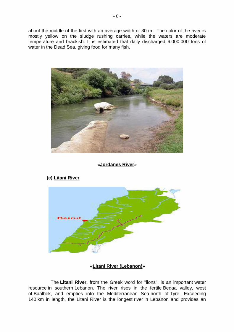
«Jordanes River»
(c) Litani River
«Litani River (Lebanon)»
The Litani River, from the Greek word for "lions", is an important water
resource in southern Lebanon. The river rises in the fertile Beqaa valley, west
of Baalbek, and empties into the Mediterranean Sea north of Tyre. Exceeding
140 km in length, the Litani River is the longest river in Lebanon and provides an
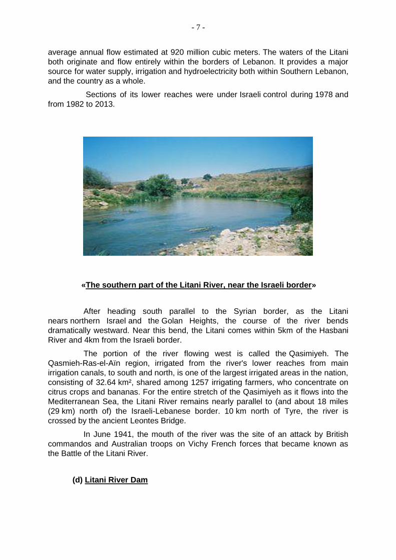
- 7 -
average annual flow estimated at 920 million cubic meters. The waters of the Litani
both originate and flow entirely within the borders of Lebanon. It provides a major
source for water supply, irrigation and hydroelectricity both within Southern Lebanon,
and the country as a whole.
Sections of its lower reaches were under Israeli control during 1978 and
from 1982 to 2013.
«The southern part of the Litani River, near the Israeli border»
After heading south parallel to the Syrian border, as the Litani
nears northern Israel and the Golan Heights, the course of the river bends
dramatically westward. Near this bend, the Litani comes within 5km of the Hasbani
River and 4km from the Israeli border.
The portion of the river flowing west is called the Qasimiyeh. The
Qasmieh-Ras-el-Aïn region, irrigated from the river's lower reaches from main
irrigation canals, to south and north, is one of the largest irrigated areas in the nation,
consisting of 32.64 km², shared among 1257 irrigating farmers, who concentrate on
citrus crops and bananas. For the entire stretch of the Qasimiyeh as it flows into the
Mediterranean Sea, the Litani River remains nearly parallel to (and about 18 miles
(29 km) north of) the Israeli-Lebanese border. 10 km north of Tyre, the river is
crossed by the ancient Leontes Bridge.
In June 1941, the mouth of the river was the site of an attack by British
commandos and Australian troops on Vichy French forces that became known as
the Battle of the Litani River.
(d) Litani River Dam

- 8 -
Qaraoun, an artificial lake of 11 square km, was created by the Litani River
Dam, 60 meters high and 1,350 meters in length, which was completed in 1959. A
spillway of 6.503 meters carries the water to the underground station where
generators produce a maximum of 185 megawatts of electricity, the
largest hydroelectric project in Lebanon. The dam was intended eventually to provide
irrigation for 310 km² of farmland in South Lebanon and 80 km² in the Beqaa Valley.
The office is at the southern (dam) end of the lake on the left side. The lakeside has
a hotel and a number of restaurants specializing in fresh trout.
(e) The Litani River Authority
The Litani River Authority (LRA) was formed in 1954 to facilitate the
integrated development of the Litani river basin. Shortly after its formation, the LRA
engaged in a massive hydroelectric development project that tapped the 850 meter
head potential between Lake Qaraoun and the Mediterranean.
This development has brought about major hydrological changes to the
Litani River Basin, where the flows from its upper reaches above Lake Qaraoun,
referred to as the “Upper Litani Basin” (ULB), are diverted through a system of
tunnels, ponds and plants, to meet the Mediterranean several kilometres north of its
original natural tail water.
These changes have resulted in the effective hydrological separation
between the ULB and the Litani lower reaches.
The advent of a protracted civil strife in the 1970s followed by a
prolonged occupation in the 1980s that lasted into the 1990s, have plunged the
country into disarray, freezing development and investment in infrastructure. The
subsequent return to normal conditions has encouraged the LRA to initiate several
major water diversion projects from the ULB worth hundreds of millions of US
dollars.
(f) Tigris River
«Tigris and Euphrates Rivers»

- 9 -
The Tigris River is the eastern member of the two great rivers that
define Mesopotamia, the other being the Euphrates. The river flows south from the
mountains of southeastern Turkey through Iraq.
The Tigris is 1.850 km long, rising in the Taurus Mountains of eastern
Turkey about 25 km southeast of the city of Elazig and about 30 km from the
headwaters of the Euphrates. The river then flows for 400 km through Turkish
territory before becoming the border between Syria and Turkey. This stretch of
44 km is the only part of the river that is located in Syria.
The Tigris unites with the Euphrates near Basra, and from this junction
to the Persian Gulf the mass of moving water is known as the Shatt-al-Arab.
According to Pliny and other ancient historians, the Euphrates originally had its outlet
into the sea separate from that of the Tigris.
Baghdad, the capital of Iraq, stands on the banks of the Tigris. The port
city of Basra straddles the Shatt al-Arab. In ancient times, many of the great cities of
Mesopotamia stood on or near the Tigris, drawing water from it to irrigate the
civilization of the Sumerians. Notable Tigris-side cities included Nineveh, Ctesiphon,
and Seleucia, while the city of Lagash was irrigated by the Tigris via a canal dug
around 2400 BC.
(g) Euphrates River
«Τigris and Euphrates River»

- 10 -
«Tigris and Euphrates River (Greek Ancient Map)» The Euphrates is the longest and one of the most historically important rivers of Western Asia. Together with the Tigris, it is one of the two defining rivers of Mesopotamia. Euphrates is originating in eastern Turkey, flows through Syria and Iraq to join the Tigris in the Shatt al-Arab, which empties into the Persian Gulf.
The Euphrates is the longest river of Western Asia. It emerges from the
confluence of the Kara Su or Western Euphrates [450 kilometers (280 mi)] and
the Murat Su or Eastern Euphrates [650 kilometers (400 mi)] 10 kilometers (6,2 mi)
upstream from the town of Keban in southeastern Turkey. The length of the
Euphrates from the source of the Murat River to the confluence with the Tigris at
3.000 kilometers (1.900 mi), of which 1.230 kilometers (760 mi) falls in Turkey, 710
kilometers (440 mi) in Syria and 1.060 kilometers (660 mi) in Iraq. The length of the
Shatt al-Arab, which connects the Euphrates and the Tigris with the Persian Gulf, is
given by various sources as 145–195 kilometers (90–121 mi).
Both the Kara Su and the Murat Su rise northwest from Lake Van at
elevations of 3.290 meters (10.790 ft) and 3.520 meters (11.550 ft) alms,
respectively. At the location of the Keban Dam, the two rivers, now combined into the
Euphrates, have dropped to an elevation of 693 meters (2.274 ft) alms. From Keban
to the Syrian–Turkish border, the river drops another 368 meters (1,207 ft) over a
distance of less than 600 kilometers (370 mi). Once the Euphrates enters the Upper
Mesopotamian plains, its grade drops significantly; within Syria the river falls 163
meters (535 ft) while over the last stretch between Hit and the Shatt al-Arab the river
drops only 55 meters (180 ft).
The Euphrates receives most of its water in the form of rainfall and
melting snow, resulting in peak volumes during the months April through

- 11 -
May. Discharge in these two months accounts for 36 percent of the total annual
discharge of the Euphrates, or even 60–70 percent according to one source, while
low runoff occurs in summer and autumn. The average natural annual flow of the
Euphrates has been determined from early- and mid-twentieth century records as
20,9 cubic kilometers (5,0 cu mi) at Keban, 36,6 cubic kilometers (8,8 cu mi)
at Hit and 21,5 cubic kilometers (5,2 cu mi) at Hindiya. However, these averages
mask the high inter-annual variability in discharge; at Birecik, just above the Syrian–
Turkish border, annual discharges have been measured that ranged from a low
volume of 15,3 cubic kilometers (3,7 cu mi) in 1961 to a high 42,7 cubic kilometers
(10,2 cu mi) in 1963.
The discharge regime of the Euphrates has changed dramatically since
the construction of the first dams in the 1970s. Data on Euphrates discharge
collected after 1990 show the impact of the construction of the numerous dams in
the Euphrates and of the increased withdrawal of water for irrigation. Average
discharge at Hīt after 1990 has dropped to 356 cubic meters (12.600 cu ft) per
second (11,2 cubic kilometers (2,7 cu mi) per year). The seasonal variability has
equally changed. The pre-1990 peak volume recorded at Hit was 7,510 cubic meters
(265,000 cu ft) per second, while after 1990 it is only 2,514 cubic meters
(88,800 cu ft) per second. The minimum volume at Hit remained relatively
unchanged, rising from 55 cubic meters (1.900 cu ft) per second before 1990 to 58
cubic meters (2.000 cu ft) per second afterward.
« Keban Dam (Turkey)»
(3) Strategic importance of the Middle East
(a) Geo - Politics: We will try in general lines to search and briefly analyze the strategic importance of the Middle East, with the help of geopolitics and specifically with the assistance of its two main dimensions, which are the “Geo-Strategic” and the “Geo-

- 12 -
Economic”, because we will derive necessary information which will help us to perceive where can lead the existing shortage of water in the Middle East. 1/ Geo - Strategic: As we know, it examines in general the strategic importance of the entire world’s areas based on the “3 geometrical dimensions”, which are the “length”, the “width” and the “altitude”. a/ “Length”: Comprises the following 4 branches7: 1/ “Phicio – Strategic” a/ It examines the position of the states on the map, the distances among them the wealth of their land and the existence of communications (Land, Air, Sea). b/ Concerning “PhicioStrategic” almost all the countries of the Middle East have huge strategic importance, (which in substance is identified with the universal strategic value of the Middle East), because the most of them are in the “centre of the earth”, as means “Mediterranean”8, and mainly near by or close to critical universal geographical “points – regions” of our planet map. The majority of course chiefly is in the region of the Eastern Mediterranean, as for example are the strategic straight of the Tunisia, the strategic canal of Suez, the islands of Crete and Cyprus, the peninsula of Sinai, but there are also other critical universal “points – regions” near or beside to Indian Ocean, as the Arabic peninsula, the Aden Gulf, the Persian Gulf, the Hormuz Straits, etc.
7 Geopolitics and Greece, I. Mazis, I. Lukas, D. Kitsikis, Theo Couloumbis, Thanos Dokos,
Constantine Kouros, Athens 2001, Editions: “Esoptron”. You can see also the «Annex “A”». 8 Concerning geometry but also concerning the ancient Hellenic “Oracle of Delphi” the
“Mediterranean Sea” is the “Centre of the World”. If someone see the world-map will presently understand what has been through out history the important meaning for the “big powers”, in each historical period from the ancient times up to now, to control this sea and of course its strategic “point- regions”. The world-map also show us that the 3/5 of our planet are covered by sea, which means that the “power” who controls the sea, controls – in general lines – the planet. If will also someone read universal history and if will carefully consider our world’s sea lines communications, will terminate to the same conclusion.

- 13 -
As a consequence, we can say that the Middle East states directly influence or control all these universal critical “points – regions”. The distances among them are not so long, as also the distances from them to these “critical points” (From one Middle East country to another). We must mention that the main advantage of them is the fact that the Middle East countries are in the earth’s centre, or near to it. The wealth of their terrestrial and sea space is really big, because of the huge amounts of petroleum and natural gas which they have, acting simultaneously as the commissary of the universe in these specific indispensable products for the people all over the world. Finally, with regard to sea, air and land strategic communications through these states, because of their position the Middle East countries influence or proportionately control all of them. That is the reason why have historically been serious problems to the world market, which led in many time of periods in “war–engagement” of the Middle East states, (among them or between them and “third” main actors out of this region), when some leaderships of these countries created, for same or different reasons every time, serious obstacles to the freedom of these communications and mainly in the sea lines communications, with which are conducted the majority of the universal commercial transports. 2/ “Morpho” – Strategic a/ It is the consideration of the shame / form of the land (soil) and its affection to the strategic importance of the area which each time is under consideration. b/ We have said also that the land in general in the Middle East region is wealthy from the raw materials side, because of the petroleum and the natural gas which “is hidden” under the ground, in the subsoil, or in the bottom of the sea. Examining the morphology of the soil of Middle East states in Asia and in Northern Africa, we can say that there are not high mountains or mountain ranges, there are also not big plains or valleys, there are not big lakes with strategic importance, there is the “Dead Sea”, there are some heights as for example the “Golan Heights” are, big deserts as the “Desert of Sahara” is and as we have already said there are many rivers and some of them are amongst the biggest rivers in the world, as Nile, Euphrates, Tigris, etc. The rivers normally split freely, (without obstacles), the Middle East countries from which pass, but the problems begin to emerge, when some of these countries try to control the stream of the rivers either in their springs or in other points building dams, in an effort to accumulate and to gather more water for their peoples’ needs or trying for some reasons to extort neighbouring to them countries.

- 14 -
This fact in combination with the high degree of drought of all these large geographical areas in all the “Wider Middle East” leads directly to war among the states, if they don’t – finally – exist peaceful solution to their problems which each time are appeared. In this point, we must say that the Middle East and the North Africa are the poorest regions in the world in water existence, fact which enforces people to totally be depended by the rivers Nile, Jordan, Euphrates and Tigris and of course from the underground waters. 3/ Topographical – Strategic: a/ It is the consideration of the topographical importance of the world’s areas. b/ Concerning the topographical strategic firstly we must point out that in Middle East don’t particularly exist big or long topographic lines, as also don’t exist important altimeter differences among all these lines (Important differences among the existent elevation points). We must for another one time stress that in the Middle East exist the most important “points - regions” in the world, from which we can claim is depended the smoothness and the regularity of the universal life. 4/ “Meteo” – Strategic a/ It is the consideration of the affection of the weather in one area and helps us to estimate its strategic importance also. b/ The main weather – characteristics in all the Middle East are the big quantities of drought and humidity, as also the big thermometric differences between the day and night almost in every season. We have already said also that the water scarcity in Middle East is too high. We can say in general that the climate is warm in the summer and cold in the winter. These characteristics affect negatively the fertility of the region and subsequently the life of the inhabitants and of course the normal rhythm of the life in all the Middle East. We must additionally not forget that the continuing wars in Middle East after the 2nd World War have negatively affected the whole environment there. We must not forget also that the destruction of the environment is one of the most dangerous threats against the “collective defence” of our world. b/ “Width”: Comprises the following subjects: 1/ Institutional frame of the societies

- 15 -
The big majority of the Middle East inhabitants believe in Islam, being also the majority of them Sunni Muslims and the rest of them Shia (Sii) Muslims. Many of these Muslims belong in different Islamic sects, as are the Alevis, Bektasis, etc. In Middle East there are also Christians in a not so high percent, (orthodox and catholic people exist in the entire Middle East region), and Jews, mainly in Israel. In the Islamic countries we clearly have authoritarian regimes. We have for example the Sunni Saudi dynasty in Saudi Arabia, the corresponding dynasties in all the states of the Persian Gulf, (90% Sunni), the very severe regime of the Sii Islamofasists of Iran, the kingdom in Jordan, which is a shape of more free Islamic dictatorship compared with the other regimes in the same area, the Assad’s “ethno - socialistic” dynasty in Syria for more than 40 years, the despotic regimes in North Africa (Egypt, Libya, Tunisia, Algeria, Morocco ), which substantially were the main reason for their peoples uprising two years ago, (“Arab Spring”), etc. So, as result, in the Islamic Middle East states the entire institutional frame is directly developed by the Islamic leaderships based mainly in the religion without the people’s aspect, without the people’s opinion, without the popular approval of the state laws, decisions, etc. There are typically parliaments but all the possible changes are imposed by the state “heads”, all the changes or possible reforms come from the top. The people in general don’t have democratic culture not even democratic education and in the whole region in the “World History” many times lived civil wars, and generally wars among the states. The «ethno – religion» minorities are oppressed in the most of the Middle East countries. This is the rule in Middle East with some exceptions, which enforce the rule. We can say that exceptions have periodically been in Egypt, in Tunisia and the 10 last years in Turkey in which was applied by the present Prime Minister R. T. Erdoğan a scheme of a “Light Islam”, less authoritarian state in comparison with others in the region, perhaps a good example for the entire Islamic states in Middle East. We must not forget that Turkey was “in the hands” of the extreme authoritarian militaries from its establishment as Democracy (29-10-1923), until the 2003, being a secular state. Turkey has also never been real Democracy but more a “military-state”. Concerning the institutional framework, the real exception in Middle East is the state of Israel, because expresses another monotheistic religion, the “Judaism”. It has real democratic institutions, the voice of the people is strong and the parliament is really representative of the willingness of the Israeli people. The unique but too strong disadvantage for Israelis is the fact they are obliged to live in a…“military” democracy, under specific rules for their defence and for their survival, due to existent continuing threats which come from abroad (Iran, from different - Middle East - terrorists groups as Hamas, Hezbollah, etc).

- 16 -
In Middle East we can say that we have a mixture of stable Islamic dictatorships, (for instance S. Arabia), unstable and “fragile” states, (for instance Lebanon which is controlled by the terroristic organization “Hezbollah”, nowadays Egypt, etc.), a number of strong terroristic groups, (for instance the Salafists in Sinai etc), many ethno – religion people, tribes, groups, etc which form a very interesting multi ethno – cultural mosaic.
«The big majority of the people in the Middle East region are Muslims» 2/ Active economy (Nets of production) There is totally in the hands of the - authoritarian - governments, which manage the wealth of the Middle East, putting in the first raw of their priorities the gain from the sale of the petroleum and of the natural gas in the universal market, giving almost nothing to their people who are permanently poor and hungry. There are some “states – exceptions”, like Kuwait, in which people live under very good conditions in terms of their daily life. 3/ “Human factors” / entities or men who don’t live in the area and they have interests in the region All the “great powers” of our era, (USA, United Kingdom, Russia, France, Germany, etc.), because of the wealth of the Middle East, and mainly because of the petroleum and the natural gas, as also the “International Capital”, are seriously dealing with Middle East. It is estimated that the “Centre of Gravity” of the national interests of all these powers is focused in Middle East. c/ “Altitude”: It deals only with the “civilization”. It examines the culture of the regions, the culture of the countries and their affection in the formation of the character of the people. So, in Middle East, were almost born all the civilizations in the world, especially in Mesopotamia area, which is the region between Euphrates and Tigris rivers.

- 17 -
In Middle East were almost born all the religions (Judaism, Christianity and Islamism). In Middle East was also developed all the existing sciences. We can easily realize from all the above given data that the region of Middle East transfers a very heavy historical burden, something which increases in many ways its strategic importance. 2/ Geo - Economics: a/ It examines the finance importance of an area and is directly
connected with the one country’s capabilities for dominance in a specific region.
b/ We report the following remarks - facts, as arguments, in order to support the thesis that Middle East has huge universal geo-economical value, (of course its states), despite the wars often occurring from time to time in the region, and will remain for decades the “Universal Energy Storage” dominating in the universal markets of petroleum and natural gas. .
1/ Middle East states are in the “Centre of the World” controlling
the universal communications.
2/ Middle East states have huge quantities of petroleum and natural gas, as also huge quantities of waters (At least the most of them). Products or goods as petroleum, gas and water compose what we call “universal energy” and constitute the vital basis of the “Universal Economy”. 3/ Middle East states have also huge cultural heritage and deep knowledge in all the contemporary sciences and technologies. c/ It is particularly estimated that in Middle East region and not only to this will dominate in the energy sector in the future the state of Israel, as happens for decades now with the Saudi Arabia, because it has detected in its sea large amounts of gas (Tamar and Leviathan basins, etc).
«Energy Basins in Eastern Mediteranien» «Existing LNG Facilities»
Source: STRATFOR Source: Noble Energy
- 18 -
It has already begun to supply with gas countries in Central Asia and aims to do the same with the European countries through 2 energy corridors which will possibly pass each from Crete – Ionian High Seas (Pelagos) to Europe and the other from the Cyprus – Kastelorizon Island – Aegean High Seas (possibly from the 25th Meridian) – Balkans – Europe. 3/ It can be concluded from the above that the scarcity of water in the Middle East is likely to result in interstate wars since the majority of the large masses of people in the region suffer from a lack of freedom, of almost constant turmoil in their countries, jeopardizing their lives from hunger, having only the bare essentials to survive, by good and modern living, etc.
b. Factors which affect the water issue - Examination of M. East Region
(1) Population9 The Middle East and North Africa (MENA) is the most water-scarce region of the world. Home to 6,3 percent of the world's population, the region contains only 1,4 percent of the world's renewable fresh water. As population pressures in the region increase, the demand for water resources rises. Country strategies to deal with water shortages depend on local conditions, including topography, the extent of water scarcity, available financial resources, and technical and institutional capacity. Overall, developing a mix of strategies that increase supply, manage demand, and reduce long-term pressures on water is urgent more than ever before, as population pressures in the region continue to increase. Rapid population growth has exacerbated the water scarcity MENA faces. While natural factors such as intermittent droughts and limited freshwater reserves can cause scarcity, high population growth imposes additional pressures. Experts measure water availability in terms of the amount of annual renewable fresh water per person. A country is considered "water stressed" when its total renewable freshwater resources lie between 1.000 cubic meters and 1.700 cubic meters per person per year. "Water-scarce" countries have an average of less than 1.000 cubic meters of renewable fresh water per person per year. Twelve of the world's 15 water-scarce countries are in MENA.
In Annex “A” we can see the “Population Growth and Fresh Water in Middle East and North Africa” and realize better the existing problem.
9 www.prb.org/Publications/Reports / “Population Reference Bureau” / July 2002 / “Finding the
Balance: Population and Water Scarcity in the Middle East and North Africa” / Farzaneh Roudi -
Fahimi, Liz Creel, and Roger-Mark De Souza.

- 19 -
(2) Antiquated Irrigation Systems10
Irrigation systems are mostly old in the Middle East.
These systems in general have been the root causes of conflict for the water’s control in the Middle East countries after being used arbitrarily many times from the governments in the area to check the stream of river water without previous request / understanding among them.
Three separate sets of water problems persist in the Middle East, each with different players and different issues:
The first problem set involves the Jordan and Yarmuk River systems, as well as the West Bank and Gaza aquifers. Countries involved include Jordan, Israel, Syria, Lebanon, and the Palestinians of the Occupied Territories and the major issues are water flow and diversion and ownership of water sources. Israel and Jordan are at imminent risk, because of full utilization by both parties of available water resources. The situation is complicated by occasional drought situations that exacerbate the resource problem.
The second set of problems involves the Tigris and Euphrates River systems, with Syria, Turkey, and Iraq playing roles in issues as diverse as reduced water flow, constraints on irrigation, and hydropower.
The third problem area is the Nile region, comprising Egypt, Ethiopia, and Sudan. Here, the issues are flooding, siltation, water flow, and diversion.
Associated problems for all areas are pollution, especially for downstream riparians, water borne disease, and degradation of the soil through irrigation and fertilization. Ignoring these multiple problems will result in further
10 web.macam.ac.il / Water and conflict in the Middle East: Threats and Opportunities / Mary E.
Morris / Source: Studies in Conflict & Terrorism, Jan-Mar97, Vol. 20 Issue 1, p1, 13p.

- 20 -
reduction of available water resources, and existing sources, including ground water, are likely to fall below usable standards.
Indeed, many recent reports indicate that water in the Gaza Strip has already deteriorated to seriously substandard conditions as a result of seawater seepage into Gaza's fresh water aquifer and the entry of sewage into underground water supplies due to inadequate sewage infrastructure.
(3) Climate Changes
Climates changes usually affect adversely the life of the aquifer and it is possible to destroy him. The problem becomes greater when these changes are big. In the Middle East region is often such climate changes during the year and this is a basic problem on the water issue. Because of climate changes and of course because of water scarcity, generally arid conditions, and poor or outdated technologies for delivering available water, agriculture has failed to meet increasing demands placed on it by expanding populations. As a consequence, the Middle East is rapidly becoming one of the least agriculturally self-sufficient regions in the world, a trend that is destabilizing in the extreme in an area where little regional trade is conducted and where great, if not disproportionate, value is put on self-sufficiency. Governments are wary of dependency on food imports because of the heavy financial burdens they entail and the potential for strategic vulnerability that they imply. National security thus translates into food security, and food security translates into water security. We must realize that the Middle East has some of the largest oil reserves in the world, which produces most of the area's wealth, but the region's climate and environment make living harsh. The Middle East requires water resources and suitable land for agriculture. Much of the land that is available for producing food is destroyed by increasing desertification.
Desertification is a sweeping environmental problem, with vast effects in countries such as Syria, Jordan, Iraq, and Iran. Universal causes for a spread of arid environment are unsustainable agriculture practices and overgrazing. Agriculture uses 85 percent of water in this region. It is common to misuse land by heavy irrigation in the Middle East. In the area droughts are more frequent, and contribute to the changing landscape. The overuse of water in agriculture is affecting the countries' already undersized water resources.
Climate warming is also likely to have a disastrous long term ecological effect. In the Middle East, a projected one-meter sea level rise could affect over 40 percent of Egypt's productive capacity and result in salt water intrusion into major water supplies. Models also project that temperatures will raise an average of 5 to 8 degrees Celsius in the Middle East over the next century, leading to a 10-20 percent drop in precipitation, an increase in evaporation, and a corresponding decrease in available fresh water. The escalation of environmental problems in the near- to mid-term will be especially severe for countries such as Jordan and Israel, whose

- 21 -
demand already exceeds supply, and for other countries in the Middle East already plagued by economic and demographic stresses.
In times of ecological distress, aggravated by unresolved political friction, water may become a deterrent, a weapon, or a target. For example, upstream states can build, or threaten to build, dams impairing downstream flow. Downstream states can, in turn, threaten to sabotage upstream diversions. Hydraulic installations such as dams, diversion tunnels, pipelines, and desalination plants can become vulnerable to sabotage, as were desalination plants in Kuwait during the 1991 Gulf War. In addition, water shortages, especially if combined with food shortages, may precipitate population movement and migration and contribute to local unrest and regional instability.
(4) The poor quality of water projects
Water projects are common in the Middle East, but there are not water projects capable to tackle the problem of water shortage in this region. We have the Aswan High Dam on the Nile in Egypt, the Israeli National Water Carrier, and the Ataturk Dam on the Euphrates River in Turkey is but a few examples. The majority of the projects have focused on the "desalination plants". Even with a large amount of desalination plants to reduce water deficiency, the states in Middle East need to adjust its water use habits before its energy consumption doubles in 2020. Desalination plants are an overuse of water resources in the Middle East. Seventy percent of desalination plants in the world are located in this area, found mostly in Saudi Arabia, the United Arab Emirates, Kuwait, and Bahrain. While the plants produce water needed for the arid region, they can manufacture problems for health and the environment. The seawater used most in desalination plants has high amounts of boron and bromide, and the process can also remove essential minerals like calcium. Also, the concentrated salt is often dumped back into oceans where the increased salinity affects the ocean's environment. The plants harm local wildlife and add pollutants to the region's climate. In addition, desalination is the most energy-costing water resource. The “Pacific Institute” explains that the high use of energy results in raised energy prices and higher prices on water produced, hurting the consumer. The water produced can be beneficial towards substituting any lack of freshwater, but these areas have tendencies towards overuse of their natural resources. Concerns with the large amount of desalination plants in the Middle East focus on the improper dependency they will cause, instead of encouraging alternate forms of water and energy and conserving freshwater. Not even the extremely rich state of United Arabic Emirates (UAE) is an exception to the rule, which wants the states in the Middle East to face huge problems with the scarcity of the water in the whole area.

- 22 -
The United Arab Emirates, located on the Arabian Peninsula, is famous for its luxurious cities filled with lavish resorts, shopping, and attractions. The livelihoods of these extravagant emirates might create the assumption that water scarcity is not a problem for these rich states. In reality, however, the UAE is confronted with a serious depletion of their available water resources. A report from the Emirates Industrial Bank in 2005 said that the UAE had the highest per capita consumption of water in the world!..
(5) The lack of regional cooperation
History has proven that it is given the lack of cooperation between the countries in the Middle EAST general and not only for the water. The reasons are many and varied, mainly related to what is called “Diversity”. The national-religious-political-economic disparities between the states created the deep historical hate in the Middle East. (6) The imbalance of power between the states The most powerful country in the Middle East, to all sides concerned, as it has the current situation, is Israel. Ιn the strong states we can classify the states of Iran and Turkey and the most of the Gulf countries, but we have also states unstable, weak and problematic, as for example are the states of Egypt, Libya, Tunisia, Morocco, Algeria, Sudan, Syria, Lebanon, Iraq the Palestine etc. This imbalance many times leads to the arrogance the powerful states, and the weak states to operate many times as … terrorists. We must point out that in the Middle East’s mosaic we can find everything. The Sunni don’t want the Shia, the Kurds fight Turks, Syria has civil war, the citizens in North Africa as also in the Sudan area mainly suffer from starvation and lack of freedom, Iran want to erase from the map the … Zionists of the Israel, some of the Arabs support Israel, some other blame it for everything, etc. So, we can easily understand that with the above data the problem of the water scarcity is magnified.
(7) The lack of international legal agreements11 We have unfortunately lack of international agreements on the water issue in the Middle East region. Nevertheless there is a legal status12 for the allocation of river water in the region.
11 The New Water Politics of the Middle East / By Ilan Berman and Paul Michael Wihbey / [Published
in Strategic Review, summer 1999.]
12
ANNEX “B”
- 23 -
Despite this fact recognition of water’s role as an obstacle in interstate relations has spurred numerous attempts, among the states in Middle East, at resolution, including diplomatic efforts (most notably the 1953-1955 U.S. - brokered Johnston negotiations) and bilateral and multilateral treaty efforts, ranging from the 1959 “Agreement for the Full Utilization of Nile Waters” to the 1994 “Israeli-Jordanian Treaty”.
Increasingly, however, and despite these agreements, nations have begun to come into conflict over water. The natural scarcity of regional supplies, historically a point of contention, has been reduced to crisis proportions by a variety of factors.
c. Categories of water resources
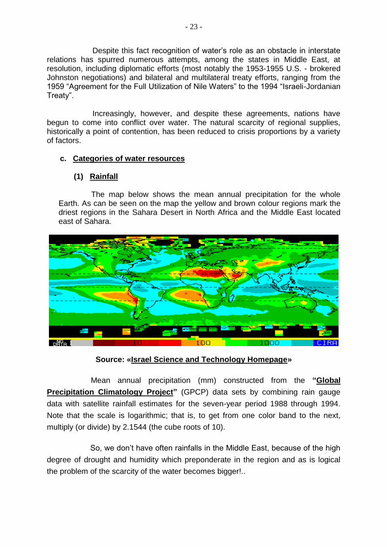
(1) Rainfall The map below shows the mean annual precipitation for the whole Earth. As can be seen on the map the yellow and brown colour regions mark the driest regions in the Sahara Desert in North Africa and the Middle East located east of Sahara.
Source: «Israel Science and Technology Homepage»
Mean annual precipitation (mm) constructed from the “Global
Precipitation Climatology Project” (GPCP) data sets by combining rain gauge
data with satellite rainfall estimates for the seven-year period 1988 through 1994.
Note that the scale is logarithmic; that is, to get from one color band to the next,
multiply (or divide) by 2.1544 (the cube roots of 10).
So, we don’t have often rainfalls in the Middle East, because of the high
degree of drought and humidity which preponderate in the region and as is logical
the problem of the scarcity of the water becomes bigger!..

- 24 -
(2) Terrestrial and Groundwater resources (Renewable - Non Renewable)13
In the Middle East, water resources are plummeting. While representing 5% of the total world population, the Middle East and North Africa (MENA) region contains only 0,9% of global water resources. The number of water-scarce countries in the Middle East and North Africa has risen from 3 in 1955 (Bahrain, Jordan and Kuwait) to 11 by 1990 (with the inclusion of Algeria, Israel and the Occupied Territories, Qatar, Saudi Arabia, Somalia, Tunisia, the United Arab Emirates and Yemen). Another 7 are anticipated to join the list by 2025 (Egypt, Ethiopia, Iran, Libya, Morocco, Oman and Syria).
In addition to its scarcity, much of Middle Eastern water stems from
three major waterways: the Tigris-Euphrates, Nile and Jordan River systems. Mutual reliance on these resources has made water a catalyst for conflict, spurring confrontations such as the 1967 War (fomented by Syria’s attempts to divert water from Israel) and the Iran-Iraq War (which erupted from disputes over water claims and availability).
Source: http://www.pentapostagma.gr/2013/05
13
ΑΝΝΕΧ «C» / Source: “World Resources 1992 - 1993”.

- 25 -
3. 3rd PART a. Analysis of Specific Cases
(1) The case of Egypt and other African countries (Nile) 14
Egypt, the chief beneficiary of Nile waters, shares the river with eight other states. Egypt is the downstream state, and is thus subject to potential risk from economic or political policy shifts in other riparian states. The Nile River provides the vast majority of water to irrigate the 3 percent of Egyptian land within the Nile Valley and delta region that can be farmed. Double and triple cropping of existing fields has brought Egypt to the limits of its farm production, even as it faces enormous population increases that will bring the number of Egyptians to 100 million.
Egypt is particularly at the mercy of Sudan, which controls the flow of the Nile into Egypt, and with whom political relations have steadily deteriorated. In 1980, the then Foreign Minister of Egypt, Boutros Boutros-Ghali in a speech to the Security Council, stated: "The national security of Egypt is in the hands of eight other African countries in the Nile Basin".
We now have 2 states of Sudan and a very strange situation of a … “cilent” civil war in Egypt, after army’s coup d’état.
Egypt in the near past has complained that Israeli engineers have assisted Ethiopia, Uganda, and Sudan in the design of new irrigation systems that could impede the flow of the Nile and imperil the Egyptian population. While these efforts have apparently ceased because of Sudan's internal turmoil and finally with Sudan’s division, future political settlements in the south could conceivably work against Egypt's interests and again increase tensions over water use. The population of N. and S. Sudan is growing rapidly as well, and desertification and land degradation have become increasing problems.
Ethiopia is in a very dangerous situation. The plight of Ethiopia shows what can happen when the wells dry. In a country troubled by civil war and periodic droughts, more than 1 million people starved during the past decade and millions of undernourished. Ethiopians are hoping to alleviate their condition draining water from the Nile River, a branch of which stems in their country. But this could cause conflict of Ethiopia with Sudan and Egypt, they also need the waters of the Nile.
14
www.pentapostagma.gr/2013/05/o-polemos-sth-syria-ginetai-gia-to nero (“The war in Syria is for the water”).

- 26 -
Ethiopia's development plans could also have a significant impact on both Egypt and Sudan. Ethiopia provides more than 82 percent of the Nile's water; with its own rapid population growth, increasing food demands, and soil erosion and desertification problems, changes in Ethiopian water policies seem inevitable. Indeed, the Ethiopian government has reportedly contemplated plans to reduce the discharge of the Blue Nile to Sudan and Egypt by as much as 4 billion cubic meters per year. Ethiopia, like Turkey, has maintained its sovereign right to develop any resources within its own borders.
At present, the only regulatory instrument among Nile riparians is a 1959 agreement between Egypt and Sudan. This agreement, drawn up after the building of the Aswan Dam, does not take into account either projected needs or the present political situation, and necessary cooperation among states seems unlikely in the current climate. Competition for Nile water is thus likely to increase, as is the potential for future conflict.
In addition to potential problems with neighbors over future water supplies, Egypt also faces severe internal problems over water use and management. In Cairo, for example, an open canal of effluent runs through residential areas to a large lake converted into an open cesspit. It is drained by a further canal into the Mediterranean Sea, contaminating both the Mediterranean and its beaches, and killing fish and wildlife.
At this point it is useful to point what happened in 2006 in Ethiopia. The valley of the Omo River in Ethiopia, at the borders with Kenya, Somalia and Sudan has been characterized by UNESCO as an important cultural area. This specific region is populated by many African tribes, rooted hundreds or thousands of years. Many of these tribes are at war with each other, because the dispute over access to some water in the area.
Omo River (Ethiopia)
In early 2006, at least 12 people were killed and more than 20 injured in clashes that broke out between members of groups Marechen and Matzeretin. The clashes erupted due to prolonged drought. It was very difficult for the people to find water. And something crucial! Experts note that the two groups lived for many years in harmony!..
(2) The case of Turkey, Syria and Iraq (Euphrates and Tigris)

- 27 -
Along the Tigris and Euphrates Rivers, Turkey and Syria are approaching a massive confrontation over water resources. Relations between the two countries, strained at best, have been exacerbated since the 1980s by growing
tensions over water, which have brought them to the brink of war several times.
In the '80s, the management of the waters of the Euphrates was a constant source of tension between Turkey, Syria and Iraq.
Despite the signing of a protocol ensuring Syrian access to Euphrates water in 1987, Turkish development efforts have increasingly threatened to marginalize and even eliminate Syrian access to water. Most notably, the
Southeast Anatolia (GAP) Project has provided Turkey, situated at the headwaters of the Tigris and Euphrates River system, extensive control over the flow of Euphrates water.
With the GAP program the waters of the river become brackish, polluted and degraded quality. We have similar consequences for the countries of the Tigris. The Turks just want water.
Turkish disruption of the flow of the Euphrates in January 1990 to fill water reservoirs in front of the Atatürk dam highlighted Syrian vulnerability to Turkish control over upstream water resources. Further complicating the issue is Syria’s continued support for the extremist PKK (Kurdish Workers’ Party), as also for PKK’s branch in Syria PYD, (“Democratic Unity Party”) in its insurgency against Turkey, a move that has prompted Turkey to threaten a blockade of water.
For many analysts the issue of Kurdistan is not only related to oil, but much more related to water issues.
At the present time of period Syria has a very brutal civil war in which participate jihadists almost from all the radical muslin areas of the planet and after 3 almost years the situation is still unpredictable.

- 28 -
At this point we must point out that some analysts claim that this civil war in Syria is a war for the water and that from behind is hidden the state of Israel. The explanation for this group of analysts is that Israel has not energy problems. After the Leviathan deposit has been found Israel will be able to feed Europe and its surrounding areas for too many years with natural gas.
Israel has acquired a vast source of energy and therefore wealth, so it is needed to insure living space. Living space acquired only in case of war (any form) and after emergence of population needs. The big and strong states, as also the great empires are not exist without water. Israel is missing water resources for farming and drinking. When these will ensure the issue of neighbours’ should manage it different and better from a position of strength.
Returning to Turkish – Syrian relations we must remind that in 1999, Syria and Turkey has reached the brink of war over the issue "Ocalan'' but ultimately the Syria banishing the Kurdish leader from its territory stopped the crisis.
In the future regardless of the form will have Syria or even Turkey in its southern and southern-eastern region because of the Kurdish issue is estimated that will have Turkish – Syrian, Turkish – Syrian Kurds, or Turkish – Kurds of Northern Iraq disputes over water could escalate into regional conflict.
Both Syria and Iraq, situated downstream from Ankara, have become increasingly threatened by Turkey’s large-scale consolidation efforts. Once fully operational, the GAP Project may reduce Euphrates water to Syria by 40% and Iraq by up to 80%.
Such activity, critical for Syria, will also be significant enough to substantially affect Iraq, currently somewhat autonomous because of its access to Tigris River water. In addition, aggressive Turkish acquisition efforts, concentrated on the GAP Project, are anticipated in the future to focus upon Tigris River water as well. Though divided in their opposition to Turkish efforts, such activity could nudge Syria and Iraq – despite their differences – into a strategic alliance, possibly destabilizing the region and precipitating a regional conflict.
Turkey, Iraq, and Syria have had territorial and political disputes dating back to the end of World War I. At that time, the founder of modem Turkey, Mustafa Kemal Atatürk, turned his nation westward, toward Europe. Since that time, Turkey has repeatedly rejected the demands of its downstream neighbors for a guaranteed share of water from the Tigris and Euphrates Rivers, both of which originate in Turkey. Because it owned the source, Turkey contended, it had the right to decide how much water its neighbors would receive.
In addition to the amount of water received, Syrians and Iraqis also worry about the quality of the water, fearing that the used irrigation water that backwashes into the rivers may carry salts, fertilizers, and pesticides. For the Syrians, the Euphrates River is the single main source of drinking, irrigation, and industrial water. Syria faces a potential loss of 40 percent of its Euphrates water because of Turkey's ambitious Southeast Anatolia (GAP) project. Iraq may lose even more.
- 29 -
Turkey has consistently accused both Syria and Iraq of aiding the radical Kurdish separatist group, the “Kurdish Workers' Party” (PKK), in its campaign against the central government; while Syria has just as consistently issued official denials of its involvement, there is strong regional feeling that such support is a just payback to Turkey for what Damascus considers its high-handed use of Euphrates waters.
In January 1990, for example, Turkey reduced the flow of the Euphrates to fill the Atatürk Dam, depriving Syria and Iraq of 500 cubic meters of water per second, leaving a trickle with which to irrigate land and generate power. Water and electrical rationing as well as crop failures in Syria and Iraq followed the Turkish action. Turkey claimed that the water blockage was only coincidental to suspected Syrian support for increased Kurdish terrorist activities in southeastern Anatolia. Regardless of Syria's responsibility for PKK activities, however, the Turkish action served to remind both Syria and Iraq that Ankara has immense leverage over its neighbors, and that downstream states are vulnerable to extortion.
After decades of wrangling with Syria and Iraq over water ownership and use, Turkey disregarded its neighbors' longstanding objections and pushed ahead with a massive hydroelectric and irrigation project in 1983. Intended to harness the Tigris and Euphrates Rivers to generate electricity and transform semiarid land into a Middle Eastern breadbasket, the GAP project was initiated without negotiating an international water use agreement with either Syria or Iraq. The $33 billion project is due for completion in 2005; it will include 19 irrigation projects to irrigate 2.5 million acres as well as 14 hydroelectric power stations and 15 dams, with the gigantic Ataturk Dam, the worlds fifth largest, as its centerpiece.
(a) The “G.A.P.” Draft (“Güney Anadolu Projesi” / “South Anatolia Project”)15
For many decades the SE Anatolia was (and unfortunately remains until now) the least economically developed region of Turkey staying well behind the rest of the country. Thanks to GAP this situation began gradually improves.
G.A.P. originally designed in the 1960s in order to harness the water's momentum Tigris and Euphrates River, and their tributaries.
Turks so far completed 40% of the project. It should be noted that there has been much delay in the project because of the political situation that still prevails in the area. (Αction of “PKK”, etc).
The initial aim was the building of 25 irrigation systems, 22 dams and 19 hydrodynamic facilities. These will produce 27 billion kwh of electricity annually and will irrigate 1,7 million arable land. The plains around Urfa and Charan will irrigate with water from the pipes of the Euphrates through tunnel 26 km each, which opened in 1994.
15
«The geopolitical role of water resources. The case of the Tigris and the Euphrates». / Fotini and Konstantinos Angelopoulos Bunia / “Andreas Papandreou Foundation”.

- 30 -
The impact these projects already have and will have on the economy of the area is impressive. Many Turkish crops will double or even tripling. The G.A.P. will ensure self-sufficiency in food in Turkey, and in addition to this will create 3,3 million new jobs . So, SE Anatolia will be met with the welfare and the gap between it and other regions will be reduced.
It is worth noting that GAP serves on the one hand, the most ambitious energy plans, but in fact is involved in a hydro – geopolitical frame, which is perceived as dangerous by its Arab neighbours. Moreover, the construction of the Ataturk dam was seen as an act of aggression against the Arab world by almost all Arab media. Purpose of Turkey, however, is to make the region of Anatolia breadbasket of the Middle East.
GAP, as a critical issue came to the Turkish parliament some years ago by 2 Turk parliamentarians (Vedat Melik and Muharrem Doğan). These 2 men reported that the GAP is an Israel’s inspiration for testing the waters of the rivers Tigris and Euphrates, and by hence to test the waters in the Middle East, presenting a wealth of information which seems huge areas of SE Turkey to be in Israeli hands.

- 31 -
In mid August 2004, the brother of Kurdish leader Abdüllah Öcalan, Osman Öcalan (Osman Öcalan), made a declaration in favour of the American intervention in Iraq. A few days later (10/09/2004), the German newspaper "Der Tagesspiegel" said Öcalan maintains excellent relations with the Israelis. Since the start of the struggle of the Kurds in Turkey: The Turkish Army has razed more than 4.500 Kurdish villages, displaced hundreds of thousands of Kurds to other areas. At least half of the flattened these passages were sold in various ways to the Israelis or to the Jews who live in U.S.A. and are the “lords of the universal capital”. This information came to light of publicity in 1994. It is certain, 19 years after, that it has been under Israeli ownership, many more passages and lands. The “Jewish Centre for Research Middle East” in Baghdad, Iraq, has a staff of more than 400 people. This centre is a covered secret headquarters of the Israeli MOSSAD, according to reliable sources of the Turkish governmental newspaper “Yeni Safak” (“New Dawn”). Since the beginning of 2005, the Israelis through multifaceted and multi-species activities, mainly in northern Iraq, have buy whole blocks and huge areas of land in Kurdish cities of Kirkuk, Mosul, Erbil and Sulaymaniyah. Culmination and confirmation of all information were the statements of Ariel Sharon (Ariel Sharon), in 2004, that Israel's relations with the Kurdish leaders Celal Talabani and Massoud Barzani are excellent as also that Israel and Northern Iraq will become strategic partnerships in the future. From the June 22, 2004, the Turkish newspapers, Milliyet, Hürriyet, Sabah and Radikal, began an unprecedented publishing data which demonstrates that Israel uses the Kurds in Iraq and Turkey, to promote the interests and presents Israeli incursions as "Israeli establishment" in that areas. Israel since 1999, participates actively in the agricultural extension programs and supply of GAP for the Northern Eastern Anatolia. In January 2004, the “National Security Council” of Turkey, in a secret report, spoke about major changes to the issue of energy pipelines, stressing that the reopening of the so-called "Ultra Israeli Pipeline» (Trans Israel Pipeline - TIP) Kirkuk - Haifa, will hit the key Turkish interests. The same period were repeatedly sabotaged the pipeline Kirkuk (Iraq) - Gioumourtalik (Turkey), which was essentially inactive now, demolishing the intentions of the Turks, for their participation in the activities and profits of Iraqi oil. Israeli conductor TIP constructed in 1968 with a capacity of 1 million barrels per day, and ends through other pipelines to the Israeli port of Eilat (Eilat), Red Sea, and Ashkelon (Askalon) in the Mediterranean. The pipeline had stopped working after the Islamic revolution in Iran. On 05/08/2006, R. T. Erdoğan inaugurated the dam “Ilision” in Tigris River, just 45 km from Syria and a huge hydroelectric plant, as part of the ambitious program “GAP”, amounting to $ 1,9 billion, which caused the reactions of the Arab League, who spoke great future risks for the Middle East, the program GAP, which

- 32 -
effectively controls the management of the waters of the Tigris and the Euphrates , unique water supplies throughout the region.
(b) “Αtatürk” DAM
The Atatürk dam is huge. This dam produces 2.400 MW, about 1/ 3 of
the energy of the whole work of GAP and irrigates half a million hectares of land. The construction lasted from 1983 to 1994. Until 1990, Turkey began to fill the lake dam and four years filled the reservoirs. The area with the filling of the lake acquires total surface 817tetr.klm and water capacity of 48,4 billion cubic meters. This barrier reflects the impact for Turkey itself, as well as for the neighbouring countries of Syria and Iraq. Turkey, in early 1990s, had in filling a reservoir, because of the irrigation needs and then the evaporative losses were minimal. The flow, from the November 1989 until early 1990s, when Turkey released the water from the reservoirs, increased from 500 cubic m. to 750 m³. Moreover, during the interruption the supply of the Euphrates was reaching at 321 million cubic meters, a result which was changed after the blackout period, reinforcing the view of Turkey that the two riparian states (Turkey and Syria) increased thanks to this the flow at 3,759 billion cub. metres. As regards the implementation of the project was taken over by a consortium (“Ata Insaat”), which included three Turkish companies. For this project required 200 million dollars to introduce machinery and equipment. Although Turkey's problems with Syria and Iraq works on the barrier never stopped and Turkey was able to secure funding from Switzerland, Germany and Italy for its purchase. It is note worthy a specific reference to the role of the tunnels. The tunnels have total length 11.000 meters and diameter 7,62 metres. The water via these tunnels flow for 4km in the northern plains of Sanliurfa - Haran and after can be converted into hydropower in hydropower plants of Sanliurfa. The water at this point will be divided in the main irrigation canal Sanliurfa, which irrigates 48.000 hectares and in the Haran Canal will irrigate 99.866 hectares. The irrigation system in the Sanliurfa region is the largest in the world, since the waters are estimated to have an area of 300.000 hectares of plain Haran (near Turkey's border with Syria). The project under normal conditions is expected to be completed in 2016. For the completion in the dam worked 600.000 workers. The project had an impact on policy, having contributed to the rise in the popularity of then Prime Minister Turgut Özal. The inauguration of the dam was finally in the winter of 1994 by President Suleyman Demirel. Finally, Turks have already made two more major dams, as the Biretsik dam is, which is the largest in the Euphrates, and the dam Karakamis which is the fifth dam on the Euphrates and is used as an additional dam of the Biretsik dam.

- 33 -
(c) The Manavgat River Project 16
Manavgat River originates on the eastern slopes of Western Taurus mountains in Turkey, and flows south over conglomerated strata for about 90 km, then over the “Manavgat Waterfall” and though the coastal plain and into the Mediterranean Sea.
An alternative to the “Peace Water Pipeline” that would not rely on diplomatic relations with Syria is that of exporting Turkish water from the Manavgat River directly to Israel. It was first discussed in 1994, with underwater pipelines, floating so-called Medusa bags and converted oil tankers all mentioned as possible methods of transportation. In 1998, the “Manavgat Project” began to supply tourist cities in northern Turkey with water. That same year, Turkey began exporting Manavgat water to the occupied by the Turks Northern part of the Cyprus in floating Medusa bags (produced by Nordic Water Supply), but only in small amounts of up to seven MCM per year. The price per cubic metre of water was set at 55 cents. The bags did not prove very reliable (or profitable) and the project was aborted after four years.
After years of negotiations and setbacks, an agreement between Israel and Turkey regarding the Manavgat water was finally signed in 2004. Fifty million cubic metres per year were to be transported to Ashkelon port (Israel) in large tankers for the next twenty years. While Turkey had already invested more than 147 million USD in storage and water treatment facilities upstream on the Manavgat, and a pipeline and offshore facilities in the Mediterranean for tankers to load the water for export, Israel had yet to construct a 13 kilometre pipeline from Ashkelon port to its national water carrier as well as a jetty at the port. These two projects were priced at over 20 million USD. An unloading facility was constructed by 2001. The deal was supposed to be effectuated by 2006, but in April of that year, the agreement was officially put on hold because it became impractical to use large tankers in a period of high oil prices.17
16
www.fanack.com / Chronicle of the Middle East & North Africa 17
(U.S. Water News, 2006)

- 34 -
Furthermore, Turkey's Manavgat water treatment facility had been privatized, increasing the already high costs. However, there are continuous rumours about new water and energy export projects between the two countries.18
Arch Dam Oymapinar Region / Manavgat River Manavgat’s Feasibility
Despite its feasibility and independence from other Middle Eastern countries, the Manavgat scheme was never an option to quench all of Israel's water problems. As part of the broader cooperation between Israel and Turkey – within the scope of the economy, the military, and tourism – the deal seemed more a political statement than a viable long-term solution. While the then Israeli Finance Minister Benjamin Netanyahu rejected the plan due to its high costs, Prime Minister Ariel Sharon said that “the importance of the deal surpasses merely the water issue, and affects the strategic relationship with Turkey”. The agreed upon Manavgat program would only have covered about 3 percent of Israel's annual water needs, a fact that proves its rather symbolic function. Although the water importation from Turkey is potentially significant, the problematic aspect of this scheme is its presupposition of broad political cooperation
18
(Journal of Turkish Weekly, 2006)

- 35 -
between the states involved. However, given the cost (look at the above table), complexity and risks within the Red Sea - Dead Sea project, the world should consider the other feasible solution to water scarcity in the region which is the water importation from Turkey (“The Peace Water Pipeline Project”).
(d) Pipes of peace (Turkey)
1/ Advantages
a/ Easy loans.
b/ Oil and natural gas at low prices.
c/ Attract Arab investments. d/ Larger share of projects in Arab.
e/ Largest share in Arab markets. 2/ Disadvantages
a/ Inability to meet agricultural needs.
b/ Dependence of the Arabs on Turkey.
c/ Direct impact on Syria and Iraq.
d/ High cost of its construction.
(3) The position of Syria and Iraq
The intertwining of Israeli and Arab water needs is but one example of how water is a security as well as a resource problem in the Middle East. Syria and Iraq have a long history of enmity, much of it rooted in political differences manifested in conflicting claims to resources. One of the most serious disputes between the neighboring states occurred in 1974-1975 when Iraq accused Syria of reducing the Euphrates River's flow to a trickle, thereby endangering the lives of 3 million Iraqi farmers dependent on river irrigation water. Syria at that time built with the help of the Soviet Union a dam in the Tampka area of the Euphrates, obtaining from this river the 80% of fresh water use and the 60% for the production of electricity.

- 36 -
After trading accusations of duplicity, Syria closed its airspace to all Iraqi aircraft, suspended Syrian flights to Baghdad, and transferred troops from the Israeli border to the Iraqi border, where it claimed that Iraqi troops were massing. In return, the Iraqis threatened to bomb the Syrian dam at al-Tabqa. Saudi Arabian and Soviet intervention resulted in eventual mediation of the dispute, much of which was the consequence of the Iran-Iraq accord of 1975, which ended Iranian support for the Kurdish rebellion in Iraq and raised Syrian fears that rival Ba'athists in Baghdad would promote unrest in Syria. A second dispute over water between Syria and Iraq arose during the Gulf crisis and war of 1990-1991, when Iraq placed human shields at the al-Thawra dam in northern Iraq to prevent potential Syrian sabotage. Saddam Hussein used water as a weapon both during the Gulf War and since its end. Before Iraqis torched the Kuwaiti wellheads on their retreat from Kuwait, they deliberately released stored crude oil into the Persian Gulf in January of 1991. These spills, from two sources, combined to leave an oil slick of more than 3 million barrels, exceeding by ten times the Exxon Valdez spill in 1989 and covering some 600 square miles of sea surface and 300 miles of coastline? Tens of thousands of birds died, other marine life was badly affected, coral reefs were destroyed, and the Saudi shrimp and fishing industry was wiped out for years to come. The oil slick alone irreparably damaged a fragile marine ecosystem and threatened seepage of oil into groundwater supplies. Saddam Hussein's actions in Kuwait have been characterized as "indiscriminate environmental warfare" by the U.S. State Department. Desalination plants at Jubail and further south, the major sources of fresh drinking water for most Gulf states, was also placed at risk, and 26 gathering centers that separated oil, gas, and water from one another were either damaged or destroyed. Since the end of the “Gulf War”, Iraq has pursued a major water diversion scheme, known as the Third River, which was completed in December 1992. This project aims to reclaim up to 150 million hectares of land for agriculture in southern Iraq, and includes a new canal from Baghdad to Basra to drain salt from the water and make it suitable for irrigation. However, the plan has also drained large areas of the southern marshes, destroying the traditional habitat of the Marsh Arabs who have been in consistent low level rebellion against the central Iraqi government since the end of the Gulf War. The marshes are now being eroded, and Marsh Arabs are thus more vulnerable to ground attacks from Saddam's forces despite the allied "no-fly" zone that protects them from air attack.
(4) The position of Israel, in relation to:
(a) Lebanon
Israel's military presence since 1978 in south Lebanon also has real or perceived water implications: The Israeli presence guarantees the uninterrupted flow of the Wazzani Springs and the Hasbani River, which originate in Lebanon and flow into Israel. Lebanon has also long suspected Israel of designs on the Litani River, which originates in Lebanon's central mountains and flows into the sea 40 miles south of Beirut. Despite consistent Israeli denials of interest in the Litani because of the expense involved to successfully divert Litani waters into Israel, many Lebanese

- 37 -
remain convinced that the Litani is the real reason for the continued Israeli occupation of southern Lebanon. However, the waterway of real issue to Israel is not so much the Litani (which has a much reduced flow by the time it reaches southern Lebanon), but the Wazzani Springs, which feed into the Hasbani River. The rise of Hezbollah in Lebanon also demonstrates the link between water scarcity and increased support for radical groups. One of the main causes of unrest in Lebanon is the low standard of living and government negligence for economic development in areas of southern Lebanon, where the Shiite population mainly lives. These Shia Muslims, once a marginalized sect, organized and galvanized politically around Hezbollah ("Party of God"). In 1997, a peaceful "revolt of the hungry" evolved into a violent clash that followed after the claims of the leader of Hezbollah for greater attention to economic development, including irrigation projects in neglected southern region.
(b) Jordan and Syria
The Jordan River system has witnessed more severe international conflict over water than any other river system in the Middle East. Prior to the signing of the Jordanian-Israeli peace accord in 1994, the Jordan River area was the most likely water conflict flashpoint in the region, since both Israel and Jordan had moved into full use--and subsequent shortage conditions. The 1994 agreements, however, have, at least for the present, defused the situation, replacing confrontation with negotiation. The main source of water for Jordan is the Yarmuk River, a major tributary of the Jordan River that flows through the East Ghor Canal. Other sources of water for Jordan include aquifers of limited potential, such as the now nearly depleted Azraq Oasis that supplies Amman. The East Ghor Canal, designed by Jordan in 1957, was to be the first section of an ambitious plan, the Greater Yarmuk Project, itself an outgrowth of the water sharing agreement developed in the early 1950s by U.S. envoy Eric Johnston.

- 38 -
The project was to include the construction of two dams on the Yarmuk, including the Unity Dam on the border between Jordan and Syria, construction of a West Ghor Canal with a siphon across the Jordan River to connect it with the East Ghor, construction of seven dams to utilize seasonal flow on side wadis flowing into the Jordan, and drainage facilities. The United States agreed to finance the building of the Unity dam and the two irrigation canals, as well as Israel's National Water Carrier system, which was to divert water from the Jordan River as well. Israel was to provide Jordan annually with 100 million cubic meters of water from the Sea of Galilee. In 1964, however, Israel effectively annexed the waters of the Sea of Galilee by damming its southern outlet without international agreement and extending the National Water Carrier to the south. In retaliation, an Arab League summit conference decided to divert the northern Jordan River's tributaries, the Hasbani River and Wazzani springs in south Lebanon and the Banias River on Syria's Golan Heights, through Syria and down to the Yarmuk. The Arab headwater diversion project began in 1965; Israel responded with a series of aircraft and artillery attacks on the diversion project, which in 1967 culminated in raids into Syria and an increase in water related hostility that set the stage for the 1967 Arab-Israeli War. Israel's search for water security can be considered one of the principal causes of the 1967 war. The 1967 Arab-Israeli War resulted in an Israeli victory that increased existing Israeli fresh water reserves and ground aquifers (in the West Bank) and riparian rights over upstream tributaries to the Jordan by almost 50 percent. It disrupted work on the East Ghor Canal as well, since the ceasefire lines gave Israel control over half of the length of the Yarmuk River, compared to 10 km before the war. Further development of the Yarmuk was thus dependent upon Israeli consent. The Jordanian-Israeli peace accord of 1994, however, may alleviate much of this problem, since it provides for the building of the East Ghor Canal and the reapportionment of at least some of the disputed water between the two countries. With the emergence of the “Palestine Liberation Organization” (PLO) after the 1967 war, the struggle for water took on an increasingly political cast. The PLO mounted intensive campaigns against Israeli settlements in the Jordan Valley, peaking in 1968-1969 with raids against Israeli water installations. Israel's initial response was a series of military efforts to stop PLO activities. By 1969, however, the Israeli cabinet changed its methods: In an attempt to pressure King Hussein to move against the PLO, Israel attacked the East Ghor Canal several times, causing extensive damage to Jordanian irrigation. In 1970-1971, King Hussein expelled the PLO from Jordan and the Canal was rebuilt, although the master plan has never been implemented. While perceptions of mutual interest between Jordan and Israel have led to amicable resolution of potential crises in the last 20 years, further development work on the East and West Ghor Canals effectively has come to a standstill. Full utilization of the Canal has been hampered by the presence of silt and debris; past efforts to remove the debris have been halted by Israel for fear that the level of the Jordan River would be affected. Even if the East Ghor Canal was fully utilized,

- 39 -
however, it could not meet the needs of Jordan's rapidly increasing population, which is doubling every 18 years. In addition to water received from the Yarmuk River and West Bank aquifers, Israel derives over 20 percent of its water from the disputed Golan Heights, which contains the headwaters of the Jordan River that supplies both Jordan and Israel. Together, the West Bank and the Golan Heights contain up to two-thirds of the water Israel uses. Israeli and Syrian negotiations over the Golan Heights thus involve more than strategic issues; for both countries, access to scarce water resources is also a consideration. (c) Palestinian Territories (“Western Bank” and “Gaza Strip”)
The success of ongoing peace talks between Israel and the Palestinians, as well as with Syria and Lebanon, rests almost certainly on successful negotiation of water issues. Israel's main sources of water lie outside its pre-1967 borders, in the

- 40 -
Arab lands it now holds under military occupation. Thus, Israel cannot simply trade land for peace without ironclad assurances of resource, as well as political, security; to do so, in the case of the West Bank alone, would require the surrender of 30-40 percent of Israel's current water supply and possibly more than 50 percent of its future supply. This is a frightening prospect given projections that, by the year 2000, Israel's water needs may exceed supply by 30 percent--even without any transfer of territory and associated water rights. Israel fears that the creation of a Palestinian state on the West Bank could lead to future water deprivation if the new state pursues a policy of deep pumping of aquifers, a practice now forbidden to both Jews and Arabs because water tables are so low, or if unresolved hostilities led to sabotage or diversion of Israeli water supplies. Resources are the means of survival and development, and are essential to self rule. Thus, one of the major items to be agreed upon between Israel and the Palestinians in final negotiations over either a Palestinian entity or a Palestinian state will be control of water resources. The influx of Soviet immigrants has also had an impact on the competition for already contested resources. To the present time, Israel, whose settlers in the West Bank use at least 3 times as much water per capita as Arab inhabitants, has insisted on retaining administrative control of water sources in the Occupied Territories, especially the ancient aquifers from which both Israel and the West Bank draw most of their water. Indeed, the limited proposals for autonomy in the West Bank offered by Israel do not, to date, extend to the estimated 68,5 percent of territory that Israel occupies, but only to the Arabs residing on the land. The recently elected government of Benjamin Netanyahu also appears to be committed to an expansion of Jewish settlements in the Territories, which can only exacerbate the existing problem. The Arab population of the West Bank is entirely dependent on spring water and ground water aquifers. While all Israeli settlements and military outposts in the West Bank have piped water, 70-80 percent of Arab villages are supplied by water tank from Israel by Mekorot Ltd. Since 1967, only 34 permits for well drilling have been issued to Palestinians, all for domestic rather than irrigation uses, and all with a restriction on depth of drilling, primarily due to the low water table and because the mountainous areas of the West Bank cannot sustain intensive agriculture, partially because the aquifer is too deep for viable irrigation wells. In addition, Israel has periodically shut off water to both Gaza and the West Bank as a form of collective punishment, adding a further political element to the problem. Ground water abstraction by Israelis has also lowered the water table in some Arab villages, and there are signs of contamination of the Yarkon-Taninim aquifer by sewage effluents from Israeli settlements. Water consumption in the Golan Heights is similarly restricted, while pressure on water resources in the Gaza Strip has reached crisis proportions. There, the aquifer has been so overdrawn that there is significant evidence of seawater intrusion, making the water brackish and unusable for either domestic or agricultural use, and posing a near-term threat to the
- 41 -
survival of Gaza farms. Lack of water has thus become a major economic constraint, as well as a source of political and bureaucratic stalemate. Egypt and Israel blame each other for practices that have endangered the entire water supply in Gaza. Indeed, the problems with Gaza's water supply did not originate with Israeli control, but began in prior years, when chronic over pumping depleted local supplies. Political and bureaucratic impediments imposed by both the Israeli government and the Palestinian National Authority have made villages in the Occupied Territories increasingly dependent on cesspools to dispose of wastewater. As cesspools become overloaded they leak raw sewage, pollute groundwater sources, and create long term health risks. b. The Potential for Conflict or Cooperation The states of the Middle East share similar environmental conditions and face common water problems. These problems can be the incentive for further divisions between them. They can also be an impetus toward regional cooperation that could underpin agreements on political, social, and economic problems. The provision and protection of water is unquestionably a major challenge for Middle Eastern governments. Decisions made today through peace negotiations or through region-wide agreements, or through their failures, will have a profound impact on future generations. Indeed, current disputes over borders, religion, and ethnicity may pale in comparison to potential water conflicts. At the same time, however, water issues provide a potential opportunity for regional cooperation. Egypt and Israel, for example, have discussed in the past a possible collaboration on a half-billion dollar desalinization plant on the border between the Sinai and the Gaza Strip. A potential Israeli-Jordanian joint venture would channel Red Sea water from near Aqaba to the Dead Sea, generating mutually beneficial electricity and using reverse osmosis to desalinate Red Sea water as it drops into the Dead Sea. Other regional efforts could include development of low cost desalinization and pumping techniques, expanded water recycling, development of salt resistant crops, improvement of drip irrigation processes using Israeli developed techniques, conservation of water, and repairs to existing water carrier systems. Economies can also be restructured away from water intensive processes, such as agriculture, and existing water supplies can be supplemented by wastewater reclamation. Suggested guidelines offered by various international bodies such as the “International Law Association” and the “International Law Commission” can also be put into effect. These guidelines, based on the principles of good neighborliness, include injunctions on the diversion of water by upstream states without consultation with other riparians, joint environmental monitoring, and the development of a body of international law to deal with issues of shared water resources. The resolution of existing and potential water conflicts in the Middle East, however, depends on two critical factors: First, population growth must be contained

- 42 -
to relieve future pressures on scarce resources. While this is absolutely essential, it must also be realized that population control, even if rigorously pursued from today onward, is a long term goal--it will not reduce the numbers of people currently stressing regional systems. A more immediate goal (second critical factor) is the reduction of regional political tensions and suspicions that impede cooperative efforts of states sharing mutual resources. In this regard, the multilateral discussions on water that must always be part of the Arab-Israeli peace talks, and especially the Jordanian-Israeli agreements on water sharing, can set a vitally important precedent for the region as a whole. In addition to providing a framework for a range of cooperative efforts and having an immediate impact on one set of water issues, successful peace negotiations can establish a pattern of dialogue and communication that is now lacking in the Middle East. It can inspire confidence that cooperation, rather than conflict, can solve deep seated problems and improve, if not ensure, the quality of life for future generations. c. Prospects to resolve the problem of water It is estimated that the solution of the “water problem” in the Middle East could only come with the sincere and absolute cooperation among all the governments of the region something which is extremely difficult and perhaps is a utopia like some analysts remark and specifically with:
(1) The development of more efficient irrigation systems. (2) Education of the public. (3) The establishment of a common information bank. (4) The waste water processing. (5) The collection of rainfall. (6) The role of the private sector in managing water.

- 43 -
(7) Desalination of seawater. d. Conclusions (1) The water in the entire world and particularly in the examined Middle East region from a commodity with a human dimension became an issue with: (a) Political dimensions . (b) Economic and social dimensions. (c) Developmental dimensions. (d) Legal dimensions. (e) Strategic and geopolitical dimensions. (f) Military dimensions. (2) All the above examined dimensions: (a) Characterize the water as a factor of instability and insecurity in the Middle East. (b) Characterize the geographical area of the Middle East as permanently “under ignition area”. (c) Lead our thought and of course our research to the general conclusion that there is strong possibility of interstates wars in the future in the Middle East region due to water scarcity”.
Alexander Androutsos Infantry Colonel (HA) - / -

NATO / 5th
“SCSDS” TRADOC Armed Forces Academy Tirana, ALBANIA Dec 2013 “Research Paper” Annex “B”
«The legal status for the allocation of river water in the Middle East»
The international validation of the use of international rivers for purposes other than navigation has no binding regulation by international law which it refers explicitly to obligations or measures to be taken so far.
The General Assembly of UN commissioned in 1970 in the «International Law Commission» of the Agency to consider the «study of norms governing international watercourses for purposes other than those of a navigation perspective the gradual development and codification of these rules».
The main aim of the Commission was drafting a new general international law that defines the specific obligations of states have a limitation of their sovereignty.
The Commission, in the spring of 1991 presented to the General Assembly a first draft. Following the results of a survey of law firms of international law, which tried to define guidelines on the use of the waters of the rivers which cross more than one State, came to adopt the definition of “fair use”. As well as adopting the principle that a state can not use the soil in a way that causes a serious problem to its neighbours.
In conclusion we note that the «Union of International Law» in the context of the 52nd annual meeting held in Helsinki in the summer of 1996 resulted in the acceptance decision text known as the «Code of Helsinki» or «Helsinki Rules». According to this text was a series of proposals emphasized that the concept of «unity of the stock» is located above the regional divisions. Under Article 2 of the definition of «International River Βasin» is a geographical area which is estimated within two or more states determined by the boundaries of the watersheds of the aquatic system and includes surface and groundwater flowing into a common terminus.
Finally, articles 4 and 5 require that each basin state is entitled to a reasonable and equitable share, the definition of which is determined by each of the cases beneficial uses of the waters of an international river aporrois. They would therefore be appropriate to consider the views and suggestions regarding the pooling of water the three major countries.

- 2 -
Source: «Union of International Law», Helsinki 1996.
- / -

NATO / 5th
“SCSDS” TRADOC Armed Forces Academy Tirana, ALBANIA Dec 2013 “Research Paper” Annex “A”
A. Population Growth and Fresh Water in Middle East and North Africa
(ΜENA)
Population (millions)
1970 2001 2025 % of Population Living in Urban
Areas, 2001
Annual Renew- able Fresh
Water (km2)b
MENA 173.4 385.6 568 59 632.3
Algeria 13.8 31 43.2 49 14.3
Bahrain 0.2 0.7 1 88 0.1
Egypt 35.3 69.8 96.2 43 86.8
Iran 28.8 66.1 88.4 64 137.5
Iraq 9.4 23.6 40.3 68 96.4

- 2 -
Population (millions)
1970 2001 2025 % of Population Living in Urban
Areas, 2001
Annual Renew- able Fresh
Water (km2)b
Israel 3 6.4 8.9 91 2.2
Jordan 1.6 5.2 8.7 79 0.9
Kuwait 0.7 2.3 4.2 100 0.02
Lebanon 2.5 4.3 5.4 88 4.8
Libya 2 5.2 8.3 86 0.6
Morocco 15.3 29.2 40.5 55 30
Oman 0.7 2.4 4.9 71 1.0
Qatar 0.1 0.6 0.8 91 0.1
Saudi Arabia
5.7 21.1 40.9 83 2.4
Syria 6.3 17.1 27.1 50 46.1
Tunisia 5.1 9.7 12.5 62 4.1

- 3 -
Population (millions)
1970 2001 2025 % of Population Living in Urban
Areas, 2001
Annual Renew- able Fresh
Water (km2)b
Turkey 35.3 66.3 85.2 66 200.7
United Arab Emirates
0.2 3.3 4.5 84 0.2
Yemen 6.3 18 39.6 26 4.1
Per Capita Annual Renewable Fresh Water (m2)
% of Freshwater Use, by Sector
1970 2001 2025 Domestic Industrial
MENAa 3,645 1,640 1,113 8 5
Algeria 1,040 462 331 25 15
Bahrain 455 140 97 39 4
Egypt 2,460 1,243 903 6 8
Iran 4,770 2,079 1,555 6 2

- 4 -
Per Capita Annual Renewable Fresh Water (m2)
% of Freshwater Use, by Sector
1970 2001 2025 Domestic Industrial
Iraq 10,304 4,087 2,392 3 5
Israel 740 342 247 16 5
Jordan 555 174 103 22 3
Kuwait 27 9 5 37 2
Lebanon 1,944 1,120 896 28 4
Libya 302 114 72 11 2
Morocco 1,960 1,027 741 5 3
Oman 416 206 5 2 94
Qatar 901 170 129 23 3
Saudi Arabia 418 114 59 9 1
Syria 7,367 2,700 1,701 4 2
Tunisia 800 422 327 9 3

- 5 -
Per Capita Annual Renewable Fresh Water (m2)
% of Freshwater Use, by Sector
1970 2001 2025 Domestic Industrial
Turkey 5,682 3,029 2,356 16 11
United Arab Emirates
897 60 44 24 9
Yemen 648 228 103 7 1
% of Population With Access to Safe Water
% of Population With Access to Adequate
Sanitation
Total Urban Rural Total Urban
MENAa 84 93 79 86 95
Algeria 89 94 82 92 99
Bahrain - - - - -
Egypt 97 99 96 98 100
Iran 92 98 83 83 86
Iraq 85 96 48 79 93

- 6 -
% of Population With Access to Safe Water
% of Population With Access to Adequate
Sanitation
Total Urban Rural Total Urban
Israel - - - - -
Jordan 96 100 84 99 100
Kuwait - - - - -
Lebanon 100 100 100 99 100
Libya 72 72 68 97 97
Morocco 80 98 56 68 86
Oman 41 30 92 98 61
Qatar - - - - -
Saudi Arabia 95 100 64 100 100
Syria 80 94 64 90 98
Tunisia 80 92 58 84 96
Turkey 82 82 84 91 98

- 7 -
% of Population With Access to Safe Water
% of Population With Access to Adequate
Sanitation
Total Urban Rural Total Urban
United Arab Emirates
- - - - -
Yemen 69 74 68 38 89
Source: The UN report “Water for the Life, Water for the People” (2003) - / - B. «Geopolitical Value of Mediterranean Sea» “Agglo-Saxon” Interest and Influence Zone, between 36th and 32nd Parallel. In the internal of this zone it is possible to be developed the axis of the hydrocarbon transport among Israel – Cyprus and Crete. Source and Primary Cartography: I. Mazis, “Kapodistriakon” University of Athens.

NATO / 5th
“SCSDS” TRADOC
Armed Forces Academy
Tirana, ALBANIA
Dec 2013
“Research Paper”
Annex “C”
Source: World Resources, 1992 – 1993
- / -

NATO / 5th
“SCSDS” TRADOC Armed Forces Academy Tirana, ALBANIA Dec 2013
BIBLIOGRAPHY
1. Allan, J, A. (1999). «The Nile basin: Evolving approaches to Nile waters management». 2. Allan, T. (1999). «Israel and water in the framework of the Arab-Israeli conflict». 3. Chomsky, N. (2003), «Middle East Illusions», Rowman & Littlefield Publishers Inc. Lanham. Boulder. New York. Oxford. 4. Fawcett, L. (2005), «International Relations of the Middle East»: Oxford university press. 5. Flint, J. and Waal, A, D. (2008), «Darfur: A New History of Long War». Zed books: London. New York. 6. Jagerskog, A. (2002), «The Sanctioned Discourse: A crucial factor for understanding water policy in the Jordan River basin». Department for water and environmental studies, Linkoping University: 7. Jobson, S. (2003), «Water of strife: The geopolitics of water in the Euphrates - Tigris and Jordan River basins», The Royal Institute of International Affairs. 8. Lssar, A, S. (2000), «The Water Resources of Israel: Past, Present, and Future: A comprehensive outline», The Palestinian Centre for Regional Studies. 9. Milton-Edwards, B. (2007), «Contemporary Politics in the Middle East», Polity. - / -