Irrigated Agriculture - · PDF filefrom Cambodia to the South China Sea. Water in Cambodia is...
22
Irrigated Agriculture June 2003 Prepared by Ministry of Water Resources and Meteorology In association with Cambodia National Mekong Committee
Transcript of Irrigated Agriculture - · PDF filefrom Cambodia to the South China Sea. Water in Cambodia is...

Irrigated Agriculture
June 2003 Prepared by Ministry of Water Resources and Meteorology
In association with
Cambodia National Mekong Committee

Cambodia National Mekong Committee National Sector Review 2003: Irrigated Agriculture
Ministry of Water Resources and Meteorology i
Table of Contents TABLE OF CONTENTS ..............................................................................................................................I LIST OF TABLES....................................................................................................................................... II ACRONYMS AND ABBREVIATIONS...................................................................................................III EXECUTIVE SUMMARY ........................................................................................................................ IV 1. INTRODUCTION............................................................................................................................... 6 2. ECONOMIC IMPORTANCE OF IRRIGATED AGRICULTURE.............................................. 6
2.1. Socio Economic Development and Proposal ...........................................................6 2.2. Irrigated Land and Agriculture Production ..............................................................7 2.3. Rice Ecosystems and Irrigation ................................................................................7
3. LAND USE IN THE BASIN............................................................................................................... 9 3.1. Land Use for Irrigated Agriculture...........................................................................9 3.2. The Main Categories of Land Use for Irrigated Agriculture....................................9
4. DEVELOPMENT OF IRRIGATED AGRICULTURE ................................................................ 10 4.1. Lowland Irrigation..................................................................................................10 4.2. Irrigated Agriculture Management .........................................................................11 4.3. Land Leveling for Irrigated Agriculture.................................................................13 4.4. Groundwater Irrigation Issues ................................................................................14
5. SOCIAL AND ECONOMIC ISSUES ............................................................................................. 16 6. ENVIRONMENTAL IMPACTS OF IRRIGATION..................................................................... 18 7. INSTITUTIONAL FACTORS AFFECTING IRRIGATED AGRICULTURE ......................... 18 REFERENCES ........................................................................................................................................... 20
Cambodia National Mekong Committee National Sector Review 2003: Irrigated Agriculture
Ministry of Water Resources and Meteorology ii
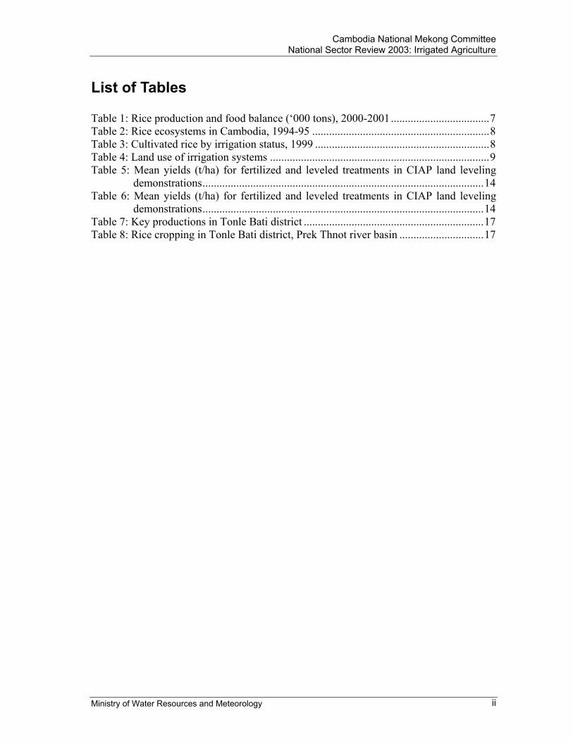
List of Tables Table 1: Rice production and food balance (‘000 tons), 2000-2001...................................7 Table 2: Rice ecosystems in Cambodia, 1994-95 ...............................................................8 Table 3: Cultivated rice by irrigation status, 1999 ..............................................................8 Table 4: Land use of irrigation systems ..............................................................................9 Table 5: Mean yields (t/ha) for fertilized and leveled treatments in CIAP land leveling
demonstrations....................................................................................................14 Table 6: Mean yields (t/ha) for fertilized and leveled treatments in CIAP land leveling
demonstrations....................................................................................................14 Table 7: Key productions in Tonle Bati district ................................................................17 Table 8: Rice cropping in Tonle Bati district, Prek Thnot river basin ..............................17
Cambodia National Mekong Committee National Sector Review 2003: Irrigated Agriculture
Ministry of Water Resources and Meteorology iii
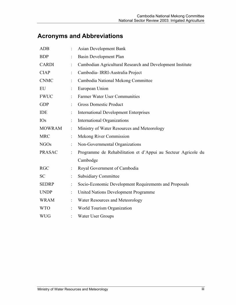
Acronyms and Abbreviations ADB : Asian Development Bank
BDP : Basin Development Plan
CARDI : Cambodian Agricultural Research and Development Institute
CIAP : Cambodia- IRRI-Australia Project
CNMC : Cambodia National Mekong Committee
EU : European Union
FWUC : Farmer Water User Communities
GDP : Gross Domestic Product
IDE : International Development Enterprises
IOs : International Organizations
MOWRAM : Ministry of Water Resources and Meteorology
MRC : Mekong River Commission
NGOs : Non-Governmental Organizations
PRASAC : Programme de Rehabilitation et d’Appui au Secteur Agricole du
Cambodge
RGC : Royal Government of Cambodia
SC : Subsidiary Committee
SEDRP : Socio-Economic Development Requirements and Proposals
UNDP : United Nations Development Programme
WRAM : Water Resources and Meteorology
WTO : World Tourism Organization
WUG : Water User Groups
Cambodia National Mekong Committee National Sector Review 2003: Irrigated Agriculture
Ministry of Water Resources and Meteorology iv
Executive Summary The part of Cambodia within the Mekong River basin generates 75,000 MCM/year of surface water runoff, and its aquifers contain an estimated 17,600 MCM of groundwater. This is more than 100 times the amount that is used at present. Annual rainfall varies between 1,400 mm and 3,500 mm. Each year, the Mekong River carries 475,000 MCM from Cambodia to the South China Sea. Water in Cambodia is used for agriculture, industry, hydropower, navigation, and tourism. The estimated total quantity used each year 750 MCM/year, of which 95% (about 710 MCM/year) is used for irrigated agriculture. There is very little reliable information on the quantities used for other purposes. Groundwater potential for irrigation is an integral aspect of Cambodia’s water balance, and provides a substantial natural storage of water that may be available to provide a year-round source of water. Currently, approximately 2.7 million hectares is effectively utilized for crop production. In 2001, 2.6 million hectares was under wet and dry season rice production. Other significant crops are maize (71,500 ha), rubber (40,000 ha), soybean (33,300 ha), vegetables (33,800 ha), and mung bean (25,000 ha). In 1999, the agriculture sector contributed to approximately 26% of the total GDP, which was about 2,014 billion Riels. Of this figure, rice accounted for 859 billion Riels, other crops for 591 billion Riels, and livestock for 564 billion Riels. Different irrigation systems have been found in lowland irrigated areas along the Mekong River, around the Great Lake of Tonle Sap, and in the associated wetland and seasonally flooded areas. Lowland irrigated agriculture is generally practiced around swamps and lakes, using a combination of canals, dikes, reservoirs, small pumps and traditional lifting devices to manage and exploit waters arriving during the annual monsoon flood. The use of surface water ponds as a source of water for farm-scale irrigation is also widespread, and newly excavated ponds can be seen in many places (no data are available on the number or rate of increase in number of ponds, however). Ponds with a surface area on the order of 400 m2 and a depth of 2-3 meters typically can provide water for irrigation through much of the dry season, particularly for application at critical times in the growth cycle. The environmental impacts resulting from the development of irrigation systems are as follows: (i) effects of changes in water flow patterns and quantities resulting from the construction of reservoirs and dams; (ii) effects of changes in water quality due to over excessive pesticide and fertilizer use; (iii) changes in habitat resulting from the draining of wetlands or creation of reservoirs; and (iv) salinity problems because of excessive irrigation in the dry season. To address the irrigated agriculture issues, the Royal Government of Cambodia has the following strategies and policies: (i) to provide farmers with the quantity of water they
Cambodia National Mekong Committee National Sector Review 2003: Irrigated Agriculture
Ministry of Water Resources and Meteorology v
need; (ii) to promote, where justifiable on economic or social grounds; (iii) to promote the development and extension of water management technologies; and (iv) to strengthen and expand Farmer Water User Communities.
Cambodia National Mekong Committee National Sector Review 2003: Irrigated Agriculture
Ministry of Water Resources and Meteorology 6
1. Introduction The part of Mekong River basin in Cambodia generates 75,000 MCM/year of surface water runoff, and its aquifers contain an estimated 17,600 MCM of groundwater. This is more than 100 times the amount that is used at present. Annual rainfall varies between 1,400 mm and 3,500 mm. Each year, the Mekong River carries 475,000 MCM from Cambodia to the South China Sea. Quantity of water in Cambodia is used for many purposes, such as for household, agriculture, industry, hydropower, navigation, tourism, etc. The estimate total quantity used each year is about 750 MCM/year, of which 95% (about 710 MCM/year) is used for irrigated agriculture. There is very little reliable information on the quantities used for other purposes. Groundwater potential for irrigation is an integral aspect of Cambodia’s water balance, and provides a substantial natural storage of water that may be available to provide a year-round source of water. There are insufficient data and information about the distribution, quantity, and quality of groundwater. Based on the concept of the rehabilitation and development of water resources, water use for irrigation still remains as an active movement with the support from the RGC and external organizations. The management and development of irrigation system throughout the country is very crucial element for the reduction of poverty.
2. Economic Importance of Irrigated Agriculture
2.1. Socio Economic Development and Proposal Inability to manage water flows is likely the most serious constraint on agricultural growth in Cambodia, because of the considerable variability in rainfall (RGC, 2001). The RGC is thinking on appropriate a response has evolved rapidly. The Interim Poverty Reduction Strategy Paper presented the following proposals:
“Where technically and economically feasible, the rehabilitation of existing irrigation facilities would be carried out to provide equity in access to irrigation water and to boost agricultural production in food insecure areas. The short to medium term strategy is to encourage a private sector-led shallow tube well and low-lift pump irrigation development program. The development of medium to large scale, gravity irrigation schemes should only be resorted to after the institutional capacities at all levels is sufficiently developed for the design and implementation of such systems. The government’s water policy objectives are to expand fully irrigated areas from 16 to 20 percent of the total rice cultivation areas over the period of five years to 2003 through the development of appropriate irrigation facilities, enhanced local ownership and control, increased private sector involvement in irrigation development and enhanced capability for operation and maintenance by local government units and water user communities.”
Cambodia National Mekong Committee National Sector Review 2003: Irrigated Agriculture
Ministry of Water Resources and Meteorology 7
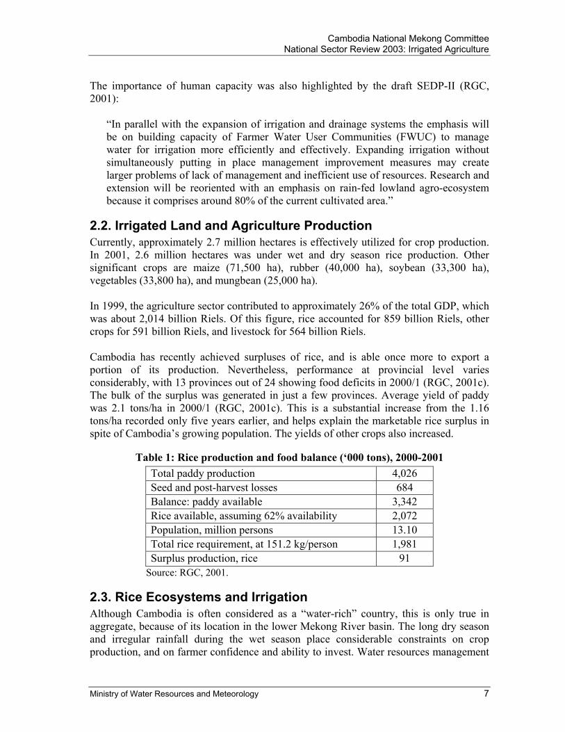
The importance of human capacity was also highlighted by the draft SEDP-II (RGC, 2001):
“In parallel with the expansion of irrigation and drainage systems the emphasis will be on building capacity of Farmer Water User Communities (FWUC) to manage water for irrigation more efficiently and effectively. Expanding irrigation without simultaneously putting in place management improvement measures may create larger problems of lack of management and inefficient use of resources. Research and extension will be reoriented with an emphasis on rain-fed lowland agro-ecosystem because it comprises around 80% of the current cultivated area.”
2.2. Irrigated Land and Agriculture Production Currently, approximately 2.7 million hectares is effectively utilized for crop production. In 2001, 2.6 million hectares was under wet and dry season rice production. Other significant crops are maize (71,500 ha), rubber (40,000 ha), soybean (33,300 ha), vegetables (33,800 ha), and mungbean (25,000 ha). In 1999, the agriculture sector contributed to approximately 26% of the total GDP, which was about 2,014 billion Riels. Of this figure, rice accounted for 859 billion Riels, other crops for 591 billion Riels, and livestock for 564 billion Riels. Cambodia has recently achieved surpluses of rice, and is able once more to export a portion of its production. Nevertheless, performance at provincial level varies considerably, with 13 provinces out of 24 showing food deficits in 2000/1 (RGC, 2001c). The bulk of the surplus was generated in just a few provinces. Average yield of paddy was 2.1 tons/ha in 2000/1 (RGC, 2001c). This is a substantial increase from the 1.16 tons/ha recorded only five years earlier, and helps explain the marketable rice surplus in spite of Cambodia’s growing population. The yields of other crops also increased.
Table 1: Rice production and food balance (‘000 tons), 2000-2001 Total paddy production 4,026 Seed and post-harvest losses 684 Balance: paddy available 3,342 Rice available, assuming 62% availability 2,072 Population, million persons 13.10 Total rice requirement, at 151.2 kg/person 1,981 Surplus production, rice 91
Source: RGC, 2001.
2.3. Rice Ecosystems and Irrigation Although Cambodia is often considered as a “water-rich” country, this is only true in aggregate, because of its location in the lower Mekong River basin. The long dry season and irregular rainfall during the wet season place considerable constraints on crop production, and on farmer confidence and ability to invest. Water resources management
Cambodia National Mekong Committee National Sector Review 2003: Irrigated Agriculture
Ministry of Water Resources and Meteorology 8
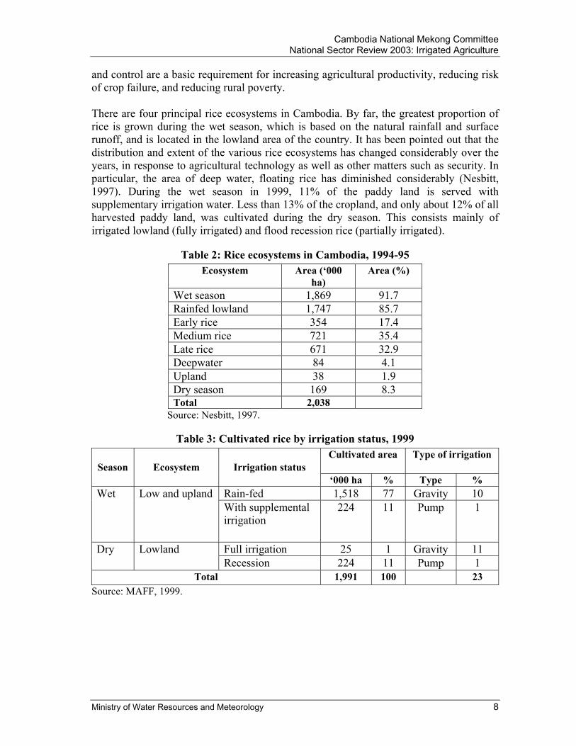
and control are a basic requirement for increasing agricultural productivity, reducing risk of crop failure, and reducing rural poverty. There are four principal rice ecosystems in Cambodia. By far, the greatest proportion of rice is grown during the wet season, which is based on the natural rainfall and surface runoff, and is located in the lowland area of the country. It has been pointed out that the distribution and extent of the various rice ecosystems has changed considerably over the years, in response to agricultural technology as well as other matters such as security. In particular, the area of deep water, floating rice has diminished considerably (Nesbitt, 1997). During the wet season in 1999, 11% of the paddy land is served with supplementary irrigation water. Less than 13% of the cropland, and only about 12% of all harvested paddy land, was cultivated during the dry season. This consists mainly of irrigated lowland (fully irrigated) and flood recession rice (partially irrigated).
Table 2: Rice ecosystems in Cambodia, 1994-95 Ecosystem Area (‘000
ha) Area (%)
Wet season 1,869 91.7 Rainfed lowland 1,747 85.7 Early rice 354 17.4 Medium rice 721 35.4 Late rice 671 32.9 Deepwater 84 4.1 Upland 38 1.9 Dry season 169 8.3 Total 2,038
Source: Nesbitt, 1997.
Table 3: Cultivated rice by irrigation status, 1999 Cultivated area Type of irrigation
Season Ecosystem Irrigation status ‘000 ha % Type %
Rain-fed 1,518 77 Gravity 10 Wet Low and upland With supplemental irrigation
224 11 Pump 1
Full irrigation 25 1 Gravity 11 Dry Lowland Recession 224 11 Pump 1
Total 1,991 100 23 Source: MAFF, 1999.

Cambodia National Mekong Committee National Sector Review 2003: Irrigated Agriculture
Ministry of Water Resources and Meteorology 9
3. Land Use in the Basin
3.1. Land Use for Irrigated Agriculture The Mekong River Commission (2002) has recently compiled a survey of irrigation systems or projects in the Lower Mekong River basin. Their findings, and those from earlier surveys, are summarised in. There are approximately 1,000 systems included in the MRC inventory. However, the earlier inventory prepared by Halcrow (1994) indicated that only about 21% of the total 841 systems identified in 1994 were fully operable, and about 14% were completely inoperable. Owing to poor or no design and/or inadequate construction methods – particularly during the Khmer Rouge regime (1975-79), when many systems were constructed – many structures or entire systems are of little value, or are positively harmful to water management. The Halcrow (1994) inventory provided a useful summary of the types of irrigation system found in Cambodia. These are not all operated and maintained by smallholders, and inputs from the Royal Government are provided in many cases. Nevertheless, the farmers are, in general.
Table 4: Land use of irrigation systems MOWRAM
(2000) MRC (2002)
Number of systems 946 1,055 Area of wet season irrigation (ha) 256,120 258,908 Area of dry season irrigation* (ha) 143,490 184,566 Total irrigated area (ha) NA 402,493
3.2. The Main Categories of Land Use for Irrigated Agriculture The irrigation systems can be divided into four main categories of irrigations:
- Canals off-taking in the Mekong basin from natural lakes, rivers or streams by gravity. Level control may be provided by barrages or diversion weirs, although in many cases off-takes are uncontrolled. These systems have no storage and are used for wet season supplementary irrigation, with some limited double cropping where water is available. These systems account for 15% by number and 21% by area of the operational systems recorded.
- Canals abstracting from rivers via pump stations provided by the Government. The pumps, typically 500 l/s in capacity, are either mounted on pontoons or installed in pump houses. Systems on perennial rivers of Mekong basin have the potential for double cropping. The responsibility for operating the pumps lies with the farmers. In the event of breakdown the situation is not clear, but in practice the Provinces generally have no funds for such work, and if the farmers cannot carry out the repairs (as is normally the case) then the pump remains broken. These systems account for 5% by number and 7% by area of the operational systems recorded.
- Reservoirs storing water from run-off, streams or rivers in the basin for
supplementary wet season irrigation and, in some instances, a small dry season
Cambodia National Mekong Committee National Sector Review 2003: Irrigated Agriculture
Ministry of Water Resources and Meteorology 10
area. Water is abstracted from the reservoirs by gravity or mobile pumps provided by the farmers. These systems account for 45% by number and 43% by area of the operational systems recorded.
- Reservoirs storing flood waters from the Tonle Sap/Bassac/Mekong system and
released by gravity or mobile pumps for a dry season recession crop only. In some cases water may be abstracted directly from the rivers without storage reservoirs. These systems accounted for 35% by number and 29% by area of t he operational systems recorded.
Canal distribution networks are usually very limited and the farmers are required to construct channels and in-field works to ensure their water supply. Furthermore many of the canals are not in command, necessitating the use of mobile pumps or traditional lifting methods. The mobile pumps are typically of 10-30 l/s capacity and used by individual farmers or small groups of farmers to lift water from the channels to their fields. Traditional methods are commonly used by low-income farmers and include the “Rohat” (pedal pump), “Kleng” (oscillating flume), and “Snach” (tripod water shovel). These methods are time-consuming and have only a very small capacity. Commonly, it is difficult to organise and maintain concerted management of water by the farming community. In these areas, then, agriculture is largely on a rain-fed, single land-holding basis. During the last ten years, a number of systems have been rehabilitated, most recently the ongoing Stung Chinit system (7,000 ha) at Kampong Thom province. Promotion of Farmer Water User Communities is a key element of the Royal Government Cambodia’s policy on irrigated agriculture, to enhance cooperation among farmers to manage water efficiently and ensure sustainability of the systems. Further, there are many signs around the country that individual smallholders are adopting small-scale methods of irrigation, in some places with the assistance of NGOs. Hence, Cambodian agriculture is poised to recover from the setbacks of the last three decades of instability.
4. Development of Irrigated Agriculture
4.1. Lowland Irrigation Very distinctive management systems for rice cropping in Cambodia are found in lowland irrigated areas along the Mekong and Tonle Sap, around the Great Lake, and in the associated wetland and seasonally flooded areas. Lowland irrigated agriculture in general is practiced around swamps and lakes, using a combination of canals, dikes, reservoirs, small pumps and traditional lifting devices to manage and exploit waters arriving during the annual monsoon flood (Pich Veasna's report, 2002). Much of the infrastructure dates from earlier decades, and there often is limited management and maintenance of the systems. Water management tends to be restricted to the use by individual farmers of lifting devices to supply water to their fields.

Cambodia National Mekong Committee National Sector Review 2003: Irrigated Agriculture
Ministry of Water Resources and Meteorology 11
A particularly distinctive aspect of lowland irrigated agriculture is recession farming. As river, lake and wetland, water levels fall after the flood peak in October/November; the first available fields along the receding water’s edge are used as nurseries. From these, seedlings are transplanted to fields in succeeding recession areas, as water levels continue to fall. Water may be pumped back up to the higher fields for supplementary irrigation, using small mobile pumps or traditional lifting devices. Water is taken from the receding water or natural depressions, from behind storage bunds (which also often have a dual purpose as road embankments and storage bunds), or from ponds constructed to store water. Cropping in the lowland areas is limited to the non-flooded period. There are two basic dry season paddy cropping patterns, namely flood recession paddy and dry season paddy with irrigation, and some upland crops also are cultivated in the early wet season before flooding. A distinctive system of irrigated agriculture used in the central lowland of Cambodia is the so-called “colmatage” system, in which canals are constructed to lead water from the Mekong and Bassac rivers through the natural levees to the floodplain and wetlands behind. The canals supply water to the “upland” and recession fields; as floodwaters recede, the colmatage canals themselves become a source of water, which is lifted to the fields by small mobile pumps or traditional lifting devices. Colmatage farming is quite dependent on the level and duration of river flood levels, so farmers must be flexible in their operations. Small mobile pumps increasingly are used to supply water to crops. Apart from rice growing, areas of lowland irrigated agriculture also are used extensively for other crops, particularly including corn and vegetables. Relatively high yields are obtained in such areas, due to a combination of natural fertilization by flood-borne silt (from Mekong and Bassac rivers), access to water, and dry season weather conditions that are conducive to plant growth. Indeed, the lowland irrigation systems support a diverse range of resource uses, including capture fisheries, forest conservation, and supply of firewood, maintenance of natural biodiversity, and maintenance of the rural landscape that is so much a part of Cambodia’s identity (Pich Veasna, 2002).
4.2. Irrigated Agriculture Management There are several hundred irrigation systems in varying states of operation in Cambodia, mostly small to medium (<100 ha and 100-500 ha respectively) in scale. It is difficult to generalise about system management, because management approaches and effectiveness vary widely. The relative roles of the various provincial authorities (the provincial Department of Water Resources and Meteorology, Ministry of Rural Development, Ministry of Agriculture Forestry and Fisheries), NGOs, international organisations (IOs), and the farmers themselves also vary. There is a strong push to establish Farmer Water User Communities (FWUC) to take responsibility for management of irrigation systems, and a National Policy on Participatory Irrigation Management and Development has been promulgated.
Cambodia National Mekong Committee National Sector Review 2003: Irrigated Agriculture
Ministry of Water Resources and Meteorology 12
Preparatory studies for rehabilitation of the Stung Chinit Irrigation scheme (at the North) included appraisal of a number of farmer-managed irrigation systems in villages nearby (GRET, 2001). Summary descriptions of some of these are included here, to represent water management approaches in such circumstances. The Veal Ampil irrigation system, nominally serves 1,200 to 1,300 ha in 8 villages, and is based on a dyke that diverts water from the perennial Ta Prok river, Kampong Thom province (GRET, 2001). The system makes use of some of the gates and secondary canals constructed under the Khmer Rouge regime (1975-79) for the now largely defunct in the area of Stung Chinit River. Around half the families operate a double rice cultivation system, with one short term and one medium term crop grown during the wet season. The first crop is sown and/or transplanted in mid April to early May, and harvested in late July. The second crop is transplanted, from nurseries established in May and kept for 2 to 2½ months, during mid to late July, with harvest in late December. Water management by the farmers appears to be functional, but with difficulties. The Veal Ampil village chief is responsible for system management, with assistance from three other villagers; none receives payment. Veal Ampil village funds most of the maintenance work, which requires around 1 million Riel/year. Funds are collected from villagers, at no fixed rate of fee (contributions range from 500 to 20,000 Riel/year), and villagers also participate voluntarily in maintenance. Other villages contribute little or nothing; as a result (or a cause), system management favours Veal Ampil villagers. However, when villages strongly disagree about water allocation, the commune chief intervenes to negotiate a resolution. The Oh Svey system is based on a water gate constructed in 1998 on the Ta Prok river, Kampong Thom province (at the North), with funds from the World Food Programme and Social Fund for Cambodia (GRET's report 2001). A committee was established of seven members from the three communes involved, to manage the system. Unfortunately, by 2000 year, the gate was inoperable. Conflict quickly arose between villagers upstream, whose land was flooded by the gate during the wet season, and villagers downstream, who wanted to use the gate and reservoir to protect their land from flooding. The management committee met only once, to discuss water fees. The Tuk Chhar system is located in Kampong Cham province, and provides supplementary wet season irrigation to a command area of about 3,000 ha. By 2000, total cultivated area was 320 ha. It was successively rehabilitated during 1995-98 by ADB, World Food Programme, and PRASAC. PRASAC (EU) involvement was sought in 1998 because of rapid deterioration of the system during the previous three years. The rehabilitation had been entirely structural, with no input on system and water management by the villagers themselves. GRET (2001, p. 42) observe that “the law of the strongest was prevailing, and villagers damaged water control structures in order to secure water access. There was competition between villages on the four major canals and between farmers on each of the thirty tertiary canals. This competition was materialised by payments in order to get access to water, which led to anger and
Cambodia National Mekong Committee National Sector Review 2003: Irrigated Agriculture
Ministry of Water Resources and Meteorology 13
equipment degradation.” Difficulties were particularly evident during the fishing season (November-December) and at transplanting time (May-June). PRASAC was requested to establish participatory management by a Farmer Water Users Committee, which progressively would take responsibility for management of the re-rehabilitated system. The organization that was developed includes:
- Water User Groups (WUG) for each of the 30 tertiary canals, with an elected leader and deputy.
- A Subsidiary Committee (SC) in each of the four major canals, of which the WUG elected members are members. The SCs elect a chairman and deputy.
- Scheme Management Committee, chosen by the SCs. Water distribution is the responsibility of PRASAC staff and the farmer representatives; the latter do the job, with monitoring by PRASAC. The intention, according to GRET (2001) was to settle a water fee based on dry season rice cultivation area. Difficulty has been experienced in motivating farmers to get involved in the WUGs, apparently because they regard it as an external project. Farmer representatives also are not highly motivated, because they do not receive compensation. GRET comments, “The point is that Tuk Chhar reservoir (Kampong Cham province) is a difficult place to organise villagers. Some villagers still try to destroy water gate locks at night. There can be some violence, as some of them do not respect project and local authorities. Another point is that land measurement does not get villagers’ cooperation. They see it as a way to establish a fee ” This experience of a lack of cooperation among farmers is repeated in other areas, and appears to be associated with a reaction against the authoritarianism of the last three decades, and a widespread breakdown in trust. It will take time to reverse, and the RGC, NGOs and IOs are actively promoting cooperation at the local level, particularly through the SEILA programme of community government, and establishment of Farmer Water User Communities.
4.3. Land Leveling for Irrigated Agriculture The Cambodia-Australia-IRRI Project (CIAP) has been developing and testing a farming system that provides an opportunity to diversify food production. It involves remodeling the land by creating paddy and “upland” cropping areas, in association with ditches (channels or canals) and dykes (banks). The ditches can be used as a water source for irrigation; the upland area provides better-drained land that is suitable for non-rice crops. So far, five trials on areas of 0.3 to 0.5 ha have been considered by CIAP. Rice and a second non-rice crop have been grown on the lowland areas and wide ranges of vegetables, other field crops, and tree fruit crops have been trailed on the upland areas. Fish, duck and geese have been produced in the ditches. A major constraint on production in the trial areas is the infertility of the soils, particularly after land remodeling has brought sub-soils to the surface. This effect of land remodeling is greatest in the first year, and appears to decline in subsequent years. Cash income over a four-year period is three times higher from the diversified system using rice, fruit trees, subsidiary crops and
Cambodia National Mekong Committee National Sector Review 2003: Irrigated Agriculture
Ministry of Water Resources and Meteorology 14
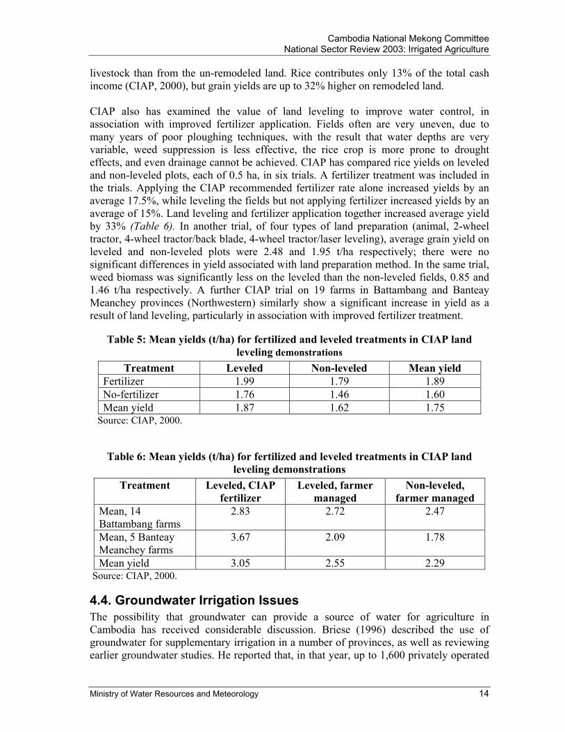
livestock than from the un-remodeled land. Rice contributes only 13% of the total cash income (CIAP, 2000), but grain yields are up to 32% higher on remodeled land. CIAP also has examined the value of land leveling to improve water control, in association with improved fertilizer application. Fields often are very uneven, due to many years of poor ploughing techniques, with the result that water depths are very variable, weed suppression is less effective, the rice crop is more prone to drought effects, and even drainage cannot be achieved. CIAP has compared rice yields on leveled and non-leveled plots, each of 0.5 ha, in six trials. A fertilizer treatment was included in the trials. Applying the CIAP recommended fertilizer rate alone increased yields by an average 17.5%, while leveling the fields but not applying fertilizer increased yields by an average of 15%. Land leveling and fertilizer application together increased average yield by 33% (Table 6). In another trial, of four types of land preparation (animal, 2-wheel tractor, 4-wheel tractor/back blade, 4-wheel tractor/laser leveling), average grain yield on leveled and non-leveled plots were 2.48 and 1.95 t/ha respectively; there were no significant differences in yield associated with land preparation method. In the same trial, weed biomass was significantly less on the leveled than the non-leveled fields, 0.85 and 1.46 t/ha respectively. A further CIAP trial on 19 farms in Battambang and Banteay Meanchey provinces (Northwestern) similarly show a significant increase in yield as a result of land leveling, particularly in association with improved fertilizer treatment.
Table 5: Mean yields (t/ha) for fertilized and leveled treatments in CIAP land leveling demonstrations
Treatment Leveled Non-leveled Mean yield Fertilizer 1.99 1.79 1.89 No-fertilizer 1.76 1.46 1.60 Mean yield 1.87 1.62 1.75
Source: CIAP, 2000.
Table 6: Mean yields (t/ha) for fertilized and leveled treatments in CIAP land leveling demonstrations
Treatment Leveled, CIAP fertilizer
Leveled, farmer managed
Non-leveled, farmer managed
Mean, 14 Battambang farms
2.83 2.72 2.47
Mean, 5 Banteay Meanchey farms
3.67 2.09 1.78
Mean yield 3.05 2.55 2.29 Source: CIAP, 2000.
4.4. Groundwater Irrigation Issues The possibility that groundwater can provide a source of water for agriculture in Cambodia has received considerable discussion. Briese (1996) described the use of groundwater for supplementary irrigation in a number of provinces, as well as reviewing earlier groundwater studies. He reported that, in that year, up to 1,600 privately operated
Cambodia National Mekong Committee National Sector Review 2003: Irrigated Agriculture
Ministry of Water Resources and Meteorology 15
tube wells were being used for supplementary irrigation of rice crops – up to 3 ha per well, in Prey Veng provinces (Southeastern), as well as providing water to newly excavated fish ponds. He also reported that 3,000 treadle pumps were in operation in these two provinces, as a result of promotion by the NGO International Development Enterprises (IDE). In Prey Kabbas District in Takeo province (Southern part), several hundred farmers had followed the example of a single farmer who in 1995 drilled a 25m depth of tube-well to enable supplementary irrigation of three crops a year. Data assembled by CARDI (Pao Sinath, personal communication, 2002) indicate that by 2001 of 1,140 pumps were being used by farmers in Takeo Province, drawing on over 3,000 open wells and over 300 tube wells (and, presumably, also open ponds). Briese (1996), suggested that one tube-well could irrigate up to 3 ha (that is, two to three farms), but also observed that farmers generally prefer to work on an individual basis. The importance of having one or a few leaders (“early adopters”), who are copied by others around them, is indicated by the way that groundwater-based irrigation has spread in Takeo province. Most NGO interventions use demonstration farms or work with a few farmers, thereby establishing points from which new ideas can spread. For instance, in Kok Roveang village, Prey Veng province (at the South), an NGO provided one household with a treadle pump for irrigating vegetables in the 1994, dry season. By the end of 1997, after seeing the results, 91 households (78% of the village) had followed suit (Roberts, 1998). The geology of Mekong lowland consists broadly of alluvial material overlying shale, slate and sandstone bedrock. The low hills and Plateau areas situated above the general level of the plain are generally underlain by igneous intrusion or limestone. The depth of alluvium is 70 m or more. The alluvium consists of sandy silt in the upper part and of clayey silt in the lower. There are occasional sand beds of up 1 m thickness. Two types of alluvium are recognized, an older one and a younger one. The younger alluvium is situated under the Mekong and Tonle Sap Lake flood Plain. Except for the occasional thin sandy beds and lenses, the alluvium is low hydraulic conductivity and the rate of yield is very low, typically 0.2L/s. Yield from the sandy layer are higher, typically of the order of 1L/s. For those wells that have UNICEF records, almost 76,00 yield more than 3l/s, while less than 3% are reported as having yields in excess of 10 m3/hr (2.7L/s). A case study of two villages in Prey Veng province has shown that the introduction of groundwater-based irrigation in this province enables farmers to change their cropping practices significantly (Roberts, 1998). Instead of one wet-season crop using medium- and long-term varieties, farmers are able to grow a first irrigated crop in the dry-wet season transition period (mid-March to harvest in July/August) and a second irrigated crop in the wet-dry season transition period (October to harvest in January-March). Irrigation is used, in effect, to extend the length of the wet season by about three months. A short-term rain-fed crop also is squeezed in between the two irrigated crops by a significant number of farmers. In the study villages, farmers use groundwater on 17% and 41% of their total land area to grow irrigated crops; they spread their risk by growing a
Cambodia National Mekong Committee National Sector Review 2003: Irrigated Agriculture
Ministry of Water Resources and Meteorology 16
variety of rice crops, and also continue to use the traditional rain-fed varieties because they have a have a higher sale price. There is still uncertainty regarding the extent of aquifers able to provide flows of water adequate for agricultural purposes, as well as concern that unregulated abstraction could over-exploit the resource. RGC (1999) suggested, “Extensive and good shallow aquifers, which span an estimated 4.8 million ha, underlie most of the arable areas of Cambodia.” However, more recent experience – unfortunately anecdotal and not supported by formal surveys – indicates that the scope for groundwater-based irrigation might be more limited, and that farmers tend to prefer to develop surface water sources, particularly ponds. IDE found few problems in obtaining groundwater in the “delta provinces” of Prey Veng, Takeo and Kandal, where aquifers are shallow and recharged by the Mekong system. However, in areas where bedrock is close to the surface or the alluvium is silt or sandy-silt and clay, so that wells yield lesser flow rates, usable groundwater is more difficult to find. More ever, there is anecdotal evidence that use of groundwater has reduced crop yields in some localities, and in extreme cases has harmed soil chemistry and structure. This is said to have been because of high concentrations of iron, salt, and other solutes in groundwater drawn from deltaic sediments or sourced from the Elephant Mountains, although data on the quality of groundwater give little reason to think that this is a significant factor. Briese (1996) concluded, in summary, that farmers are very willing to install tube well/pump systems for irrigation, particularly if they have their own system and complete control over their own water supply. A number of NGOs and IOs have been promoting the use of groundwater, particularly through the establishment of demonstration farms, with individual farmers obtaining their own systems from private sector suppliers (well drillers, pump suppliers) when convinced. Briese suggested, however, that the Government has an essential role in defining the true extent of groundwater reserves that have adequate water quantity and quality, as well as in helping farmers to adopt new methods, inter alias by provision of credit to purchase the equipment.
5. Social and Economic Issues A variety of land and water management for irrigation methods are in use by government and water user community, both at their own initiative and with the active facilitation or assistance of NGOs. A number of organizations have been carrying out researches to develop and testing some of these methods. The principal method of water control is by the construction of bunds around the rice fields to provide the depth of water required for crop water management and weed control. There is a close relationship between the rice varieties used, field level and water depth, and soil type. In many localities, farmers grow other crops such as vegetables, sugar palm, and various fruit. Livestock rising generally is important, with most farmers raising chickens, pigs

Cambodia National Mekong Committee National Sector Review 2003: Irrigated Agriculture
Ministry of Water Resources and Meteorology 17
and ducks for consumption and sale, and oxen or buffalo for draught power. For non-rice crops, a large variety of cropping systems are used, some of which involve supplementary irrigation. (Apart from vegetables, very small areas of non-rice crops are fully irrigated). For instance, maize is grown under rain-fed conditions along river floodplains, where the soil receives an annual replenishment of silt, to maintain fertility. The crop is planted at the beginning of the wet season rains, and harvested prior to the floods in September. In the Tonle Bati area, of the total 6,900 ha of the study area, 5,100 ha (74%) are under rain-fed wet season rice. Average farm size is 1.3 ha. Farmers concentrate on rice production to attain self-sufficiency in food, and because rice cultivation is still the most reliable industry in the area. Nevertheless, most fields have no stable irrigation water supply and proper drainage. Farmers grow other crops like maize, cassava, sweet potatoes, vegetables, but the area is small – about 50 ha – in comparison with the areas allocated for rice. Bananas, coconuts, mango, guava etc are grown as home garden crops. Sugar palm harvesting is particularly significant to the local economy, with the trees generally grown along the field bunds. Livestock rising also is very important, and fishing, based entirely on capture of natural stocks, also is common.
Table 7: Key productions in Tonle Bati district Items Total Value* (Million
Riel) Value (%)
Paddy (t) 6,570 2,628 70 Palm sugar (t) 190 152 4 Cattle (head) 1,430 372 10 Pig (head) 6,200 496 13 Poultry (head) 41,250 124 3 Total 3,772 100
Source: Nippon Koei, 1995. (*) Value in 1993 currency The yield of rice is very low, generally in the range between 1.2 and 1.5 t/ha depending on varieties, rate of fertilizer application, year-to-year variations in growing conditions, soil types. Over 2.5 t/ha usually is obtained for fully irrigated rice during the dry season.
Table 8: Rice cropping in Tonle Bati district, Prek Thnot river basin Season Area (ha) Production (t)
Early (transplanted May, harvested Aug-Sep, duration 110 days)
300 360
Medium (transplanted June, harvested Nov-Dec, duration 120-150 d)
4,100 4,920
Late (sown June-July, harvested Dec-Feb; duration 150-180d)
1,000 1,200
Dry Season 30 90 Total 5,430 6,570
Sources: Nippon Koei, 1995.

Cambodia National Mekong Committee National Sector Review 2003: Irrigated Agriculture
Ministry of Water Resources and Meteorology 18
6. Environmental Impacts of Irrigation The environmental impacts resulting from the development of irrigation systems are as following:
- Effects of changes in water flow patterns and quantities resulting from the construction of reservoirs and dams;
- Effects of changes in water quality due to the over excessive pesticide and fertilizer uses;
- Changes in habitat resulting from the draining of wetlands or creation of reservoirs; and
- Salinity problems because of excessive irrigation in the dry season. It has been indicated that the environmental impacts resulting from the development of irrigation systems in Cambodia are relatively small as many of the potential programs/projects involved have been made only for the existing irrigation schemes.
7. Institutional Factors Affecting Irrigated Agriculture At present, many farmers are adopting methods of water delivery that rely on cheap portable pumps, drawing water from perennial watercourses and lakes, groundwater, or dug ponds. The RGC’s strategy is to encourage such developments, because it provides rapid and affordable means of improving water control at the scale of the individual farm. On the other hand, there is a serious risk that uncoordinated exploitation of water resources may lead in a short time to degradation of the resource, and to conflict among users. A draft Law on Water Resources Management, which is a basis tool for regulating use of water, is presently passing through the legislative body. However, the enforcement of this law, once it is passed, will be a major exercise. The responsible agency, the MOWRAM, is presently not well prepared for this task; as a result, institutional capacity building needs to be considered. The followings are the classification of irrigation scales: Small scale irrigation (service area <200 ha): the system is managed by the District Office of Water Resources and Meteorology (WRAM), or by the Provincial Department of WRAM, if in more than one district; it is operated and maintained by the beneficiaries, under WRAM supervision. Medium scale irrigation (service area 200ha - 5,000 ha): the system is managed by the Provincial Department of WRAM, or by the MOWRAM if in more than one province. It is maintained by the Provincial Department of WRAM in cooperation with users, and is repaired by MOWRAM. Large scale irrigation (>5,000 ha): the system is managed and maintained by Ministry of Water Resources and Meteorology.
Cambodia National Mekong Committee National Sector Review 2003: Irrigated Agriculture
Ministry of Water Resources and Meteorology 19
The RGC recognizes the need for farmers to be involved in irrigation system operation and maintenance in order to ensure the long-term sustainability of systems. FWUC is responsible for operating and maintaining agricultural water supply facilities and managing the supply of water, in compliance with Circular No. 1 of the RGC on the Implementation Policy for Sustainable Irrigation Systems. The Circular and associated draft Irrigation Policy provide, inter alias, for FWUC constitutions, water service fees, and allocation of responsibilities and duties. About 100 FWUCs now exist in 14 provinces, covering 84,000 ha; and they are being extended as resources permit, particularly in the context of rehabilitation of irrigation systems. To address the irrigated agriculture issues, the RGC has developed the following strategies and policies:
- To provide farmers with the quantity of water they need, when and where they need it, at a cost they and the wider community can afford, and within the limits of available water resources, technology, and financial resources for investment.
- To promote, where justifiable on economic or social grounds, the rehabilitation
and construction of irrigation, drainage, and flood management infrastructure, in order to provide sufficient water for agricultural production and to alleviate the adverse consequences of excess water.
- To promote the development and extension of water management technologies
that are particularly suited to rain-fed agricultural areas, such as water harvesting, improvements to the moisture-holding capacities of soils, use of farm ponds, and sustainable extraction from groundwater.
- To strengthen and expand Farmer Water User Communities, to enable them to
participate in water management and allocation and to maintain irrigation infrastructure with effectiveness and sustainability.
Cambodia National Mekong Committee National Sector Review 2003: Irrigated Agriculture
Ministry of Water Resources and Meteorology 20
References Briese, E., 1996. Technical report on prefeasibility assessment of the shallow
groundwater resources of Cambodia. Asian Development Bank report on TA No. 2554-CAM.
CIAP, 2000. Annual research report, 1999. Cambodia-IRRI-Australia Project, Phnom Penh.
GRET, 2001. Stung Chinit project: complementary studies, 18 April-22 May 2000. Final report. Groupe de recherche et d’échange technologiques, Paris.
Halcrow (Sir William Halcrow & Partners Limited), 1994. Irrigation rehabilitation study in Cambodia. Inventory and analyses of existing systems. Volume 1. Main report. Mekong Secretariat, Contract No. CAM/IRS/238/93, Bangkok.
Mak Soeun, 2001. Final draft report of the Participatory Rural Appraisal (PRA) in Cambodia. WIN Project, FAO, Phnom Penh.
Mekong River Commission, 2002. Irrigation and inundation spatial databases: Final report. Mekong River Commission, Phnom Penh.
Nesbitt, H. J. (editor), 1997. Rice production in Cambodia. International Rice Research Institute, Manila.
Nippon Koei, 1995. Master plan study on the integrated agricultural and rural development project in the suburbs of Phnom Penh. Nippon Koei Co. Ltd., for Ministry of Agriculture, Forestry and Fisheries, Phnom Penh.
Pich Veasna, 2002. Country paper on multi-functional roles of paddy irrigation in Cambodia. Paper presented to the 3rd World Water Forum Pre-symposium, Kyoto, Japan.
RGC, 1999a. Cambodia Poverty Assessment. Ministry of Planning, Phnom Penh.
RGC, 1999b. Agricultural strategies and policy framework for sustainable food security and poverty alleviation. Ministry of Agriculture, Forestry and Fisheries, in association with UNFAO and UNDP, draft report RAPP/01/99.
RGC, 2000. Interim Poverty Reduction Strategy Paper. Ministry of Economy and Finance, Phnom Penh.
RGC, 2001a. Second Five-year Socio-economic Development Plan, 2001-2005. Ministry of Planning, Phnom Penh.
RGC, 2001b. Socio-economic development requirements and proposals, 2001-2003. Ministry of Economy and Finance, Phnom Penh.
RGC, 2001c. Agricultural statistics 2000-2001. Ministry of Agriculture, Forestry and fisheries, Phnom Penh.
RGC, 2001d. First draft of the Second Five Year Socio-economic Development Plan, 2001-2005. Ministry of Planning, Phnom Penh.

Cambodia National Mekong Committee National Sector Review 2003: Irrigated Agriculture
Ministry of Water Resources and Meteorology 21
RGC, 2001e. National Water Sector Profile for the Kingdom of Cambodia. Ministry of Water Resources and Meteorology, Phnom Penh.
Roberts, M. S., 1998. Physical and socioeconomic impacts of groundwater irrigation in the Cambodian Mekong delta. (unpublished preliminary draft report, Cornell University).
Veng Sakhon, 2000. Preparatory study on establishment of a new monitoring system for land and water resources management in Cambodia. Ministry of Water Resources and Meteorology, Phnom Penh.