IRBID RAMTHA EYN SHEMER -...
1
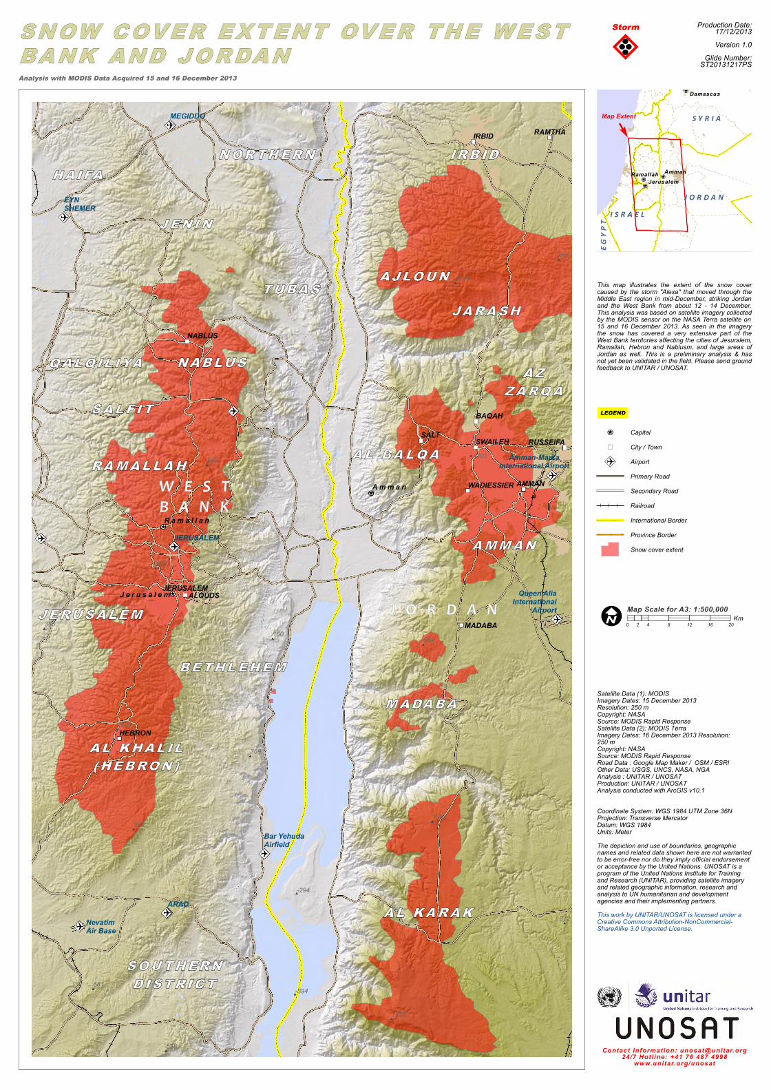
EYN SHEMER MEGIDDO ARAD JERUSALEM Amman Jerusalem Ramallah Queen Alia International Airport Amman-Marka International Airport Bar Yehuda Airfield Nevatim Air Base JERUSALEM AMMAN BAQAH IRBID MADABA RAMTHA RUSSEIFA SALT SWAILEH WADIESSIER ALQUDS HEBRON NABLUS 1103 160 369 -294 -394 380 402 958 885 910 538 1249 864 1064 1310 1020 681 961 972 Satellite Data (1): MODIS Imagery Dates: 15 December 2013 Resolution: 250 m Copyright: NASA Source: MODIS Rapid Response Satellite Data (2): MODIS Terra Imagery Dates: 16 December 2013 Resolution: 250 m Copyright: NASA Source: MODIS Rapid Response Road Data : Google Map Maker / OSM / ESRI Other Data: USGS, UNCS, NASA, NGA Analysis : UNITAR / UNOSAT Production: UNITAR / UNOSAT Analysis conducted with ArcGIS v10.1 Coordinate System: WGS 1984 UTM Zone 36N Projection: Transverse Mercator Datum: WGS 1984 Units: Meter The depiction and use of boundaries, geographic names and related data shown here are not warranted to be error-free nor do they imply official endorsement or acceptance by the United Nations. UNOSAT is a program of the United Nations Institute for Training and Research (UNITAR), providing satellite imagery and related geographic information, research and analysis to UN humanitarian and development agencies and their implementing partners. This work by UNITAR/UNOSAT is licensed under a Creative Commons Attribution-NonCommercial- ShareAlike 3.0 Unported License. Contact Information: [email protected] 24/7 Hotline: +41 76 487 4998 www.unitar.org/unosat This map illustrates the extent of the snow cover caused by the storm "Alexa" that moved through the Middle East region in mid-December, striking Jordan and the West Bank from about 12 - 14 December. This analysis was based on satellite imagery collected by the MODIS sensor on the NASA Terra satellite on 15 and 16 December 2013. As seen in the imagery the snow has covered a very extensive part of the West Bank territories affecting the cities of Jesuralem, Ramallah, Hebron and Nablusm, and large areas of Jordan as well. This is a preliminary analysis & has not yet been validated in the field. Please send ground feedback to UNITAR / UNOSAT. Storm Amman Damascus Jerusalem Ramallah EGYPT ISRAEL JORDAN SYRIA Production Date: 17/12/2013 Version 1.0 Glide Number: ST20131217PS Analysis with MODIS Data Acquired 15 and 16 December 2013 0 4 8 12 16 20 2 Km LEGEND Map Scale for A3: 1:500,000 Map Extent Capital City / Town Airport Primary Road Secondary Road Railroad International Border Province Border Snow cover extent
Transcript of IRBID RAMTHA EYN SHEMER -...
EYNSHEMER
MEGIDDO
ARAD
JERUSALEM
A m m a n
J e r u s a l e m
R a m a l l a h
Queen AliaInternational
Airport
Amman-MarkaInternational Airport
Bar YehudaAirfield
NevatimAir Base
JERUSALEM
AMMAN
BAQAH
IRBID
MADABA
RAMTHA
RUSSEIFASALT SWAILEH
WADIESSIER
ALQUDS
HEBRON
NABLUS
1103
160
369
-294
-394
380
402
958
885
910
538
1249
864
1064
1310
1020
681
961
972
Satellite Data (1): MODISImagery Dates: 15 December 2013Resolution: 250 mCopyright: NASASource: MODIS Rapid ResponseSatellite Data (2): MODIS TerraImagery Dates: 16 December 2013 Resolution: 250 mCopyright: NASASource: MODIS Rapid ResponseRoad Data : Google Map Maker / OSM / ESRI Other Data: USGS, UNCS, NASA, NGA Analysis : UNITAR / UNOSATProduction: UNITAR / UNOSATAnalysis conducted with ArcGIS v10.1
Coordinate System: WGS 1984 UTM Zone 36NProjection: Transverse MercatorDatum: WGS 1984Units: MeterThe depiction and use of boundaries, geographicnames and related data shown here are not warrantedto be error-free nor do they imply official endorsementor acceptance by the United Nations. UNOSAT is aprogram of the United Nations Institute for Trainingand Research (UNITAR), providing satellite imageryand related geographic information, research andanalysis to UN humanitarian and developmentagencies and their implementing partners.This work by UNITAR/UNOSAT is licensed under aCreative Commons Attribution-NonCommercial-ShareAlike 3.0 Unported License.
Contact Information: [email protected]/7 Hotl ine: +41 76 487 4998
www.unitar.org/unosat
This map illustrates the extent of the snow covercaused by the storm "Alexa" that moved through theMiddle East region in mid-December, striking Jordanand the West Bank from about 12 - 14 December.This analysis was based on satellite imagery collectedby the MODIS sensor on the NASA Terra satellite on15 and 16 December 2013. As seen in the imagerythe snow has covered a very extensive part of theWest Bank territories affecting the cities of Jesuralem,Ramallah, Hebron and Nablusm, and large areas ofJordan as well. This is a preliminary analysis & hasnot yet been validated in the field. Please send groundfeedback to UNITAR / UNOSAT.
Storm
Amman
Damascus
JerusalemRamallah
EGYP
T I S R A E LJ O R D A N
S Y R I A
Production Date:17/12/2013Version 1.0
Glide Number:ST20131217PSAnalysis with MODIS Data Acquired 15 and 16 December 2013
0 4 8 12 16 202Km
LEGEND
Map Scale for A3: 1:500,000
Map Extent
CapitalCity / TownAirportPrimary RoadSecondary RoadRailroadInternational BorderProvince BorderSnow cover extent