IRAQ - Kurdistan Region of Iraq Likely locations of snow ... Koysinjaq Makhmur Mergasur Lower...
1
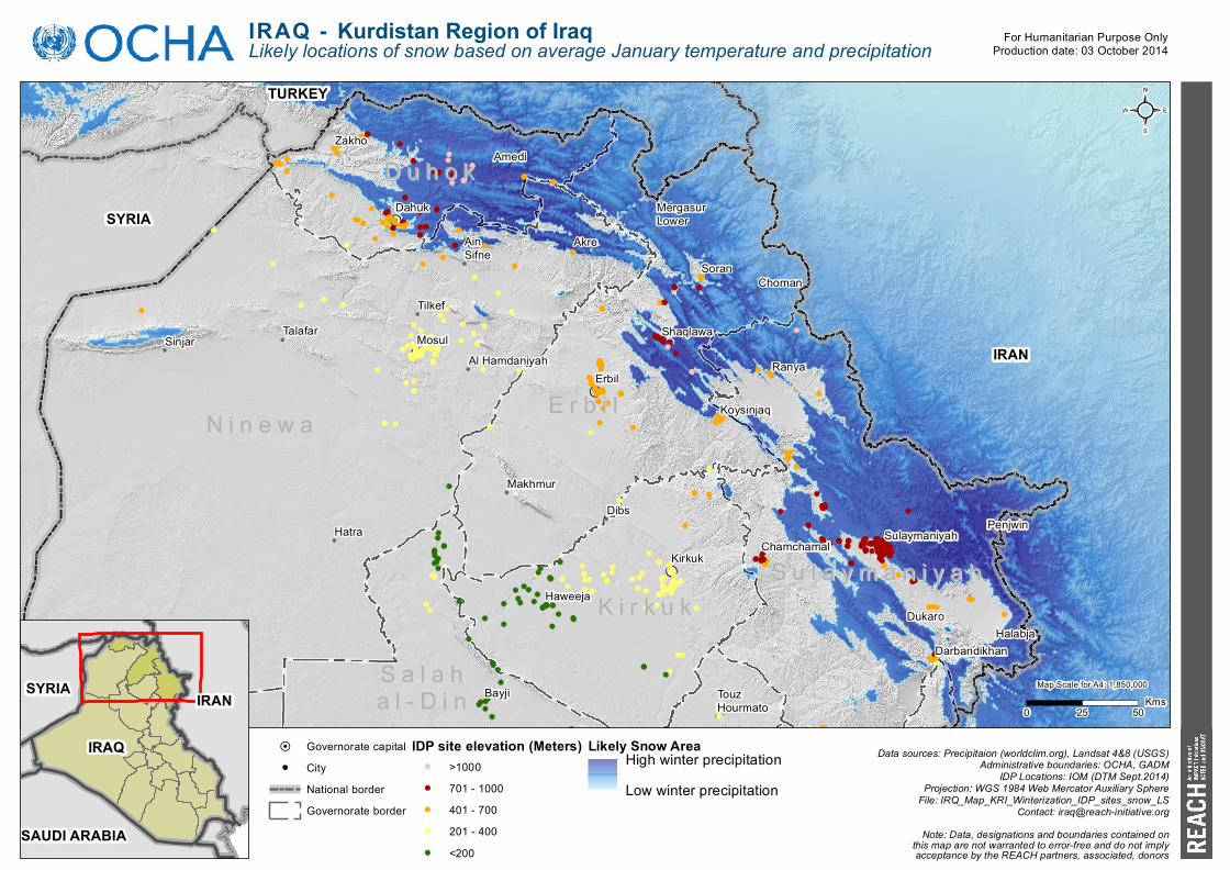
IRAQ - Kurdistan Region of Iraq Likely locations of snow based on average January temperature and precipitation ! H ! H ! H ! H ! H Duhok Duhok Erbil Erbil Ninewa Ninewa Salah Salah al-Din al-Din Sulaymaniyah Sulaymaniyah Kirkuk Kirkuk IRAN SYRIA TURKEY Amedi Dahuk Zakho Choman Erbil Koysinjaq Makhmur Mergasur Lower Shaqlawa Soran Akre Al Hamdaniyah Ain Sifne Hatra Mosul Sinjar Talafar Tilkef Bayji Touz Hourmato Chamchamal Darbandikhan Halabja Penjwin Ranya Dukaro Sulaymaniyah Haweeja Dibs Kirkuk Map Scale for A4: 1,850,000 0 25 50 Kms ² For Humanitarian Purpose Only Production date: 03 October 2014 IRAQ IRAN SYRIA SAUDI ARABIA Note: Data, designations and boundaries contained on this map are not warranted to error-free and do not imply acceptance by the REACH partners, associated, donors Data sources: Precipitaion (worldclim.org), Landsat 4&8 (USGS) Administrative boundaries: OCHA, GADM IDP Locations: IOM (DTM Sept.2014) Projection: WGS 1984 Web Mercator Auxiliary Sphere File: IRQ_Map_KRI_Winterization_IDP_sites_snow_LS Contact: [email protected] ! H Governorate capital ! City National border Governorate border IDP site elevation (Meters) >1000 701 - 1000 401 - 700 201 - 400 <200 Likely Snow Area High winter precipitation Low winter precipitation
Transcript of IRAQ - Kurdistan Region of Iraq Likely locations of snow ... Koysinjaq Makhmur Mergasur Lower...
IRAQ - Kurdistan Region of IraqLikely locations of snow based on average January temperature and precipitation
!H
!H
!H
!H
!H
A n b a rA n b a r
D u h o kD u h o k
E r b i lE r b i lN i n e w aN i n e w a
S a l a hS a l a ha l - D i na l - D i n
S u l a y m a n i y a hS u l a y m a n i y a hK i r k u kK i r k u k
IRAN
SYRIA
TURKEY
Amedi
Dahuk
Zakho
Choman
Erbil
Koysinjaq
Makhmur
MergasurLower
Shaqlawa
SoranAkre
Al Hamdaniyah
AinSifne
Hatra
MosulSinjarTalafar
Tilkef
Bayji TouzHourmato
Chamchamal
DarbandikhanHalabja
Penjwin
Ranya
Dukaro
Sulaymaniyah
Haweeja
Dibs
Kirkuk
Map Scale for A4: 1,850,000
0 25 50 Kms
²
For Humanitarian Purpose OnlyProduction date: 03 October 2014
IRAQ
IRANSYRIA
SAUDI ARABIA Note: Data, designations and boundaries contained onthis map are not warranted to error-free and do not implyacceptance by the REACH partners, associated, donors
Data sources: Precipitaion (worldclim.org), Landsat 4&8 (USGS)Administrative boundaries: OCHA, GADM
IDP Locations: IOM (DTM Sept.2014)Projection: WGS 1984 Web Mercator Auxiliary Sphere
File: IRQ_Map_KRI_Winterization_IDP_sites_snow_LSContact: [email protected]
!H Governorate capital! City
National borderGovernorate border
IDP site elevation (Meters)>1000701 - 1000401 - 700201 - 400<200
Likely Snow AreaHigh winter precipitationLow winter precipitation