INVESTIGATION OF THE SIMILARITY ALGORITHM OF THE …
20
71 Bulgarian Academy of Sciences. Space Research and Technology Institute. Aerospace Research in Bulgaria. 31, 2019, Sofia DOI: https://doi.org/10.3897/arb.v31.e06 INVESTIGATION OF THE SIMILARITY ALGORITHM OF THE SATELLITE IMAGES STORAGE SYSTEM FOR STABILITY ON THE BASIS OF HAAR WAVELETS ACCORDING TO TIKHONOV Maretta Kazaryan 1 , Mikhail Shahramanian 2 , Svetoslav Zabunov 3 1 North Ossetian State Medical University, [email protected] 2 Research Institute "AEROKOSMOS", [email protected] 3 Space Research and Technology Institute — Bulgarian Academy of Sciences, e-mail: [email protected] Key words: Wavelet-Haar transformations, The Tikhonov regularization method, Waste disposal facilities (WDF), Waste disposal site (WDS). Abstract A model of the automated space monitoring system (ASMS) for the presence of waste disposal facilities (WDFs) is being developed in this paper. One of the components of the model is the space imagery storage unit, which allows not only to improve the performance of environmental authorities, but also to enhance the effectiveness of WGF monitoring (space, aerological, and ground based). The article also investigates the problem of searching in space image archives of similarities based on Haar wavelet transformations for stability. This paper aim at modelling of an ASMS and the application of the regularization method in the problem of finding similar space images in the archives of the simulated ASMS by means of discrete orthogonal transformations, in particular, wavelet transformations of Haar. We use the Tikhonov regularization method, elements of mathematical analysis, the theory of discrete orthogonal transformations, and methods for decoding cosmic images. The result of the experiment, which confirms the Tikhonov regularization method for Haar wavelet transforms, based on the example of processing archive satellite images that are located in a data warehouse, is presented. Introduction In relation to the emergence of a variety of information technologies with their numerous capabilities, wide-range monitoring has been provided for a variety of phenomena and, accordingly, objects [1–9]. It is, first of all, the satellite systems of Earth observation and large flows of information entering the scientific laboratories. This led to the creation of new approaches and methods of organizing
Transcript of INVESTIGATION OF THE SIMILARITY ALGORITHM OF THE …

71
Bulgarian Academy of Sciences. Space Research and Technology Institute.
Aerospace Research in Bulgaria. 31, 2019, Sofia
DOI: https://doi.org/10.3897/arb.v31.e06
INVESTIGATION OF THE SIMILARITY ALGORITHM
OF THE SATELLITE IMAGES STORAGE SYSTEM FOR STABILITY
ON THE BASIS OF HAAR WAVELETS ACCORDING TO TIKHONOV
Maretta Kazaryan1, Mikhail Shahramanian2, Svetoslav Zabunov3
1North Ossetian State Medical University, [email protected]
2Research Institute "AEROKOSMOS", [email protected]
3Space Research and Technology Institute — Bulgarian Academy of Sciences,
e-mail: [email protected]
Key words: Wavelet-Haar transformations, The Tikhonov regularization method, Waste
disposal facilities (WDF), Waste disposal site (WDS).
Abstract A model of the automated space monitoring system (ASMS) for the presence of waste
disposal facilities (WDFs) is being developed in this paper. One of the components of the model is the
space imagery storage unit, which allows not only to improve the performance of environmental
authorities, but also to enhance the effectiveness of WGF monitoring (space, aerological, and ground
based). The article also investigates the problem of searching in space image archives of similarities
based on Haar wavelet transformations for stability.
This paper aim at modelling of an ASMS and the application of the regularization method
in the problem of finding similar space images in the archives of the simulated ASMS by means of
discrete orthogonal transformations, in particular, wavelet transformations of Haar. We use the
Tikhonov regularization method, elements of mathematical analysis, the theory of discrete orthogonal
transformations, and methods for decoding cosmic images.
The result of the experiment, which confirms the Tikhonov regularization method for Haar
wavelet transforms, based on the example of processing archive satellite images that are located in a
data warehouse, is presented.
Introduction
In relation to the emergence of a variety of information technologies with
their numerous capabilities, wide-range monitoring has been provided for a variety
of phenomena and, accordingly, objects [1–9]. It is, first of all, the satellite systems
of Earth observation and large flows of information entering the scientific
laboratories. This led to the creation of new approaches and methods of organizing

72
the work with information on remote sensing of the Earth (RSE), as well as the
technologies for remote monitoring systems construction.
The major factors in the field of remote sensing that affect the development
of monitoring systems are:
Growth of the number of spacecraft, resulting in increased frequency and
volume of information that can be utilized by the systems. It is now possible to
organize monitoring of rapidly occurring processes.
A large number of satellite systems are now equipped with modern technology
that allows the research of quantitative information calibration of the
phenomena and objects on Earth.
The information is quite accessible, and this leads to its extensive use.
The availability of remote sensing information has identified the need to
increase the level of automation of satellite information processing and work
with extremely large data archives.
Data processing systems need to be optimized, forming basic information
products and performing standard primary processing. The implementation of
these procedures requires considerable computing resources.
Effective work with extremely large archives and, accordingly, computing
resources leads to the creation of new technological capabilities.
To perform all the listed tasks, one must use various distributed computing
resources.
In this paper, studies are carried out in the field of waste disposal facilities
(WDFs), which will be considered while creating a specific remote monitoring
system.
WDFs are a source of risk, associated with air and soil pollution, and pose
a real threat to the population and the environment [10–12].
"The big business gurus bequeathed to their descendants: the most
profitable investment is an investment in a person's natural needs. Among other
things, a person in the process of his life leaves behind mountains of debris. Only
the population of our country annually "produces" 35–40 million tons of solid
domestic waste"1.
It is almost impossible to control these objects, scattered on a giant
territory, by means of traditional land-based methods, and the annual use of aerial
observations becomes more and more expensive and can be carried out only in
limited local areas. Under these conditions, there is no alternative to space
1http://www.rbc.ru/economics/23/08/2012/5703fbc99a7947ac81a6b045

73
monitoring as the most expeditious and cheap method for detecting and controlling
the development of unauthorized places for the WDFs.
The current article initiates a project on the creation of an automated space
monitoring system for the presence of WDFs in the territory of the Russian
Federation designed to provide an operative survey of the study area, the detection
and mapping of real and potential centres of unauthorized landfills, the forecast of
their development, a preliminary assessment of the scale of disasters and possible
consequences. It should be emphasized that such systems belong to the class of
open systems. They cannot be built in a complete form, they are in constant
development.
The initial project envisages the creation of a starter complex (core) of the
system, including the space and ground segments. An effective monitoring system
should comprise a space segment: spacecraft on circular solar synchronous orbits
equipped with active and passive sounding instruments of different spatial
resolution in the widest possible range of the electromagnetic spectrum. First of all,
it is advisable to use such public space systems such as NOAA (resolution 1100 m)
and EOS AM TERRA (resolution 250 m) for regular survey of state territory. Of
the high-resolution systems, the meteorological data "Meteor-3M" (37 m
resolution) and Indian satellites IRS 1С/1D (PAN resolution 5.6 m) are the most
accessible. It is these spacecraft that form the backbone of the space segment of the
system.
Since the research area is often restricted by a strong cloud cover, which
prevents regular space surveys in the microwave range, it is necessary to use active
sounding data, in particular, the Canadian satellite RadarSat-1, and Sentinel-1
(Copernicus). This satellite is equipped with radar, which allows obtaining high-
quality images of the Earth's surface, regardless of the presence of cloud cover and
time of day with a resolution of 8 to 100 m. In combination with space imagery in
the visible and thermal ranges, this information is extremely useful for detecting
and monitoring the development of unauthorized waste disposal facilities [9]. The
basis of the ground segment infrastructure of the ASMs WDF is the remote sensing
data acquisition system (RSAS). The most reasonable solution is to create
duplicate universal receiving stations and a distributed network for processing
space images. Creation of integrated automated WDF monitoring systems that
unite informational modelling and control systems, software complexes and
technical means of data collection and transmission on the basis of local computer
networks into a single structure, and the development of perspective models and
algorithms for forecasting foci, unauthorized WDF is an actual problem.
The functioning of space monitoring of waste disposal facilities (WDFs)
can be represented using the following scheme (Fig. 1).

74
Fig. 1. Block diagram of WDF space monitoring
In Fig. 1 the blocks are:
1. Database of existing polygons of WDF, which are listed in the state
register of solid domestic waste (SDW)2 for the current time;
2. A subsystem for detecting unauthorized WDF3 at the current time;
3. A subsystem for monitoring the rules for the design, operation and
reclamation (DOR) of existing solid waste landfills [1, 2, 10];
4. A subsystem for estimating the parameters of the WDF and their
environmental impact [2, 11, 12];
5. Subsystem of satellite monitoring.
The WDF space monitoring system functions as follows. In block II, space
images are processed by means of automation of cosmic image processing in
conjunction with detection of WDF4. Comparing the detection area of the WDF
with the data of the database of solid waste landfills in block I, unauthorized WDFs
are detected, and fixed in block II. In block IV, the WDF parameters are evaluated
for both the WDF presented in Block I and the unauthorized WDFs presented in
Block II. Using the data from Block V obtained through satellite monitoring
methods, the data of Block I and IV is collected in Block III. There, the incoming
information is further analysed, and violations of operating rules are identified for
existing landfills and the development of appropriate environmental measures.
The proposed monitoring system for landfills and WDFs (Fig. 1),
developed on the principle of extraterritoriality, allows the control the garbage
storage sites to be taken to a new information level.
2http://www.airsoft-bit.ru/stati-po-ekologii/394-groro 3http:// www.ecobiocentre.ru/naturalist/google-svalka.doc 4https://cyberleninka.ru/article/n/metodika-avtomaticheskogo-detektirovaniya-komponent-obektov-
zahoroneniya-othodov-po-kosmicheskim-izobrazheniyam
1
5
2
Space monitoring of waste
disposal facilities
3 4

75
In addition to the above described system, it is possible to consider the
creation of a system for supporting long-term data archives5 along with and its
information input. These systems are actively created in recent years to address
both fundamental and applied problems. The main task of such systems is to
collect and organize long-term data storage and to conveniently represent this data
(import this data) into the information systems of various research projects.
We will consider the use of ready-made software for storage, output and
input of monitoring data as an alternative to creating software for such systems.
The most important thing of the inner workings of such systems is the electronic
Earth’s map of the site on Earth being under research. The electronic map has a
primary interface, it identifies the objects that are of interest to us, in this case,
these are solid waste objects, authorized and unauthorized, and sampling points,
through which soil survey is carried out, etc. The operation of the system will look
like this: some kind of GIS-system with open source. Then the map and data are
loaded into it.
The drawback of this approach is that GIS systems are either not adapted to
Russian or this is done poorly. This disadvantage introduces some discomfort in
the process of work, so it is advisable for one to conduct their own development of
ASMS SWF. When creating such an information system, you must have the
following components at hand: database management systems, a web server, a
programming language development environment and, of course, a web browser.
The question of obtaining an electronic map can be solved in two ways.
The first one is to use Yandex Maps or Google Maps services. You can optionally
download the map fragment of interest in a raster format and convert it to a vector
format, so you can create an interactive map, for example, using the Inkscape
application. This method has certain specificity – in spite of a fairly simple
manufacturing method, such a map does not provide information on the
composition of the soil of the investigated section of the earth.
The second method is the use of specialized maps on paper. Complete
information is provided, including soil data, etc. One could scan such maps and
convert them to vector format. However, this approach seems rather cumbersome
due to the fact that paper maps are not always in good condition and special
computer programs for their improvement have to be applied.
Thus, summarizing the above reasoning, we may conclude that for storing
and processing of the earth monitoring data, it is possible to adapt applications to
the tasks, leading to a significant reduction in time.
5http://www.ntsomz.ru/ks_dzz/nkpoi/catalog_service

76
The next block on the information stream is the block for image
processing, i.e. space images6, 7. With the widespread implementation of digital
communication systems, the urgency of recovery problems solving, reduction of
additive noise and reconstruction of multidimensional signals, obtained with photo
and video cameras and transmitted through communication channels, is
increasing8. In practice, the images are often distorted by noise, which happens
during the formation and transmission of signals through the communication
channel. When digital images are obtained, the noise source can be a CCD
detector-spectrometer, as well as fluctuation processes in photo sensors9. The
results of image restoration are widely used in automatic signal processing
systems, in digital photo and video recording systems and machine vision. The use
of multimedia and television digital systems increases the urgency of solving the
image reconstruction problems in the reconstruction of static and dynamic two-
dimensional signals. Reconstruction of images is an important area of application
of modern digital information processing systems in obtaining a reliable estimate
for visual and especially for automatic analysis. In most cases, when solving the
reconstruction task, it is required to estimate the missing pixel values of images
and video sequences, and also to select the most "similar" section from a large
number of already existing ones. The solution of this task involves retouching and
restoring of the missing fragments of images when removing scratches, defects,
unnecessary inscriptions, etc.
Currently, the technical implementation of digital systems is intensively
developing, their speed and energy efficiency are increasing. In this case, methods
and algorithms for signal and image processing are used.
Formulation of the problem
As a practical example of the above discussion, let us consider the
following problem, which has an applied character: the search and storage of space
images in archives. In describing the digital images below, we will mean space
images (SIs).
The task is to create a similarity search system (SSS) and to search for
"similarity" in the archives of images storing WDFs based on Haar wavelet
transforms and investigating this problem for stability [21–23].
6http://window.edu.ru/resource/028/76028/files/PosobieERS.pdf 7http://files.lib.sfu-kras.ru/ebibl/umkd/54/u_course.pdf 8http://www.dissercat.com/content/korrektsiya-tsifrovykh-kosmicheskikh-izobrazhenii-na-osnove-
verifitsiruyushchego-modelirovan 9http://www.dissercat.com/content/rekonstruktsiya-smazannykh-i-zashumlennykh-izobrazhenii-
metodami-regulyarizatsii-i-usecheniy

77
Basic concepts
An important step in constructing a mathematical model of the concept of
"similarity" for storing space images is the measurement of the appearance of the
image boundaries using the Haar J-step discrete wavelet transformation (DWT)
[13–15].
As it is well known, one of the problems in image processing is to find a
way to efficiently represent an image or SI in a compact form. In modern practice
of spectral analysis, recently acquired signals of a special kind, namely, wavelets
have become quite popular. Since we are studying the SIs, we are primarily
interested in two-dimensional discrete wavelet transforms. For being ascertained
[16], the two-dimensional wavelet transforms are based on one-dimensional
wavelet transforms that do not depend on the number of rows and columns of the
image. By virtue of this rule, we consider, basically, the horizontal and vertical
directions of the wavelets. Specifically, Haar's wavelets [17, 18].
1. These are piecewise constant functions defined on intervals having
different scales and, furthermore, they take two values {–1; +1}.
2. The Haar's maternal wavelet, which has a unit scale and zero offset, is a
function that takes the value +1 on the interval [0; 1/2) and –1 on the interval
[1/2; 1).
The Haar transformation (HT) is one of the simplest basic wavelet
transforms [19]. Let Nfff ,,1 – the one-dimensional discrete signal. The HT
divides the signal into two components, the average and the difference. Suppose
we have a sub-signal 2/21
1 ,,, Naaaa consisting of mean values. It is defined
as follows:
(1)
The detail signal 2/21
1 ,,, Ndddd at the same level is determined
(2)
By means of these values, two new signals are formed:
(3) nddnaa nn ,;, .
The first of these signals represents a coarsened copy of the original, and
the second is informative or detailed for the original signal.
(4) .

78
A similar partition can be performed with respect to the vector a. Let's
consider an example with numbers. Let
(5) I =
5432
1098
7654
3210
Let us apply HT to the given matrix, using the principle of division by
rows, thus we obtain the following matrix:
(6)
11
11
11
11
95
117
139
51
2
1
We apply HT to the given matrix, using the principle of column separation
of the obtained matrix. We obtain the following:
(7)
00
00
22
22
812
88
1022
1810
2
1
Or in general form we get the following matrix:
(8)
(9) ,
Here
A – area, including information about the global properties of the analysed SI;
H – horizontal area, including information on the horizontal components of the
analysed SI;
V – vertical area, including information on the vertical components of the analysed
SI;
D – diagonal component, including information on the diagonal components of the
analysed SI.
When decomposing the image [20–24], the one-dimensional fast Haar
transformation (FHT) is applied first to the rows, and then to the columns of pixel
79
values of the input of the displayed matrix. As a result, we have a two-dimensional
wavelet transform. As a result, the SI is divided into four equal parts LL, HL, LH,
HH:
HHLH
HLLL
Fig. 2. Single application of a two-dimensional wavelet transform to a SI
LL – low-frequency wavelet coefficients (minor quadrant – reduced copy
of the original image); HH – high-frequency wavelet coefficients. N-fold two-
dimensional wavelet transform implies the application of N times the two-
dimensional wavelet transform to the lower quarter of the matrix – LL.
11
1
22
233
33
HHLH
HL
HHLH
HLHHLH
HLLL
Fig. 3. Three-fold application of a two-dimensional wavelet transforms
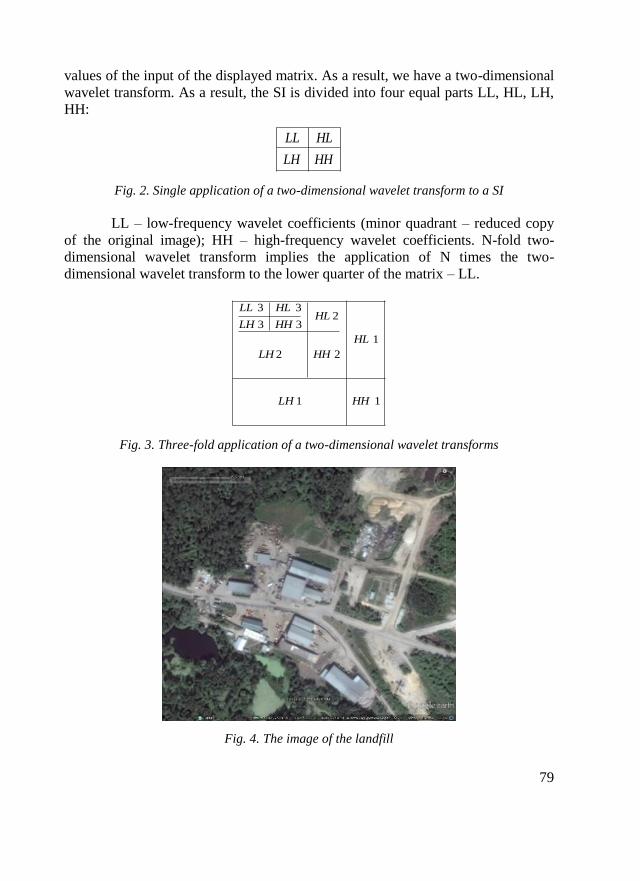
Fig. 4. The image of the landfill

80
The inverse two-dimensional wavelet transform restores the lowest
quadrant recursively. We take for the initial function of the space image, the image
of the landfill (Fig. 4).
Consider a seven-step fibreboard using db1 (Haar). According to the
structure, the database in which information on the waste disposal site (WDS) is
stored [9] is presented as:
1. Common (name, type, location, comments, notes, etc.);
2. Geographical parameters (coordinates in different geographical
projections, adjacent and including administrative-territorial units (AU),
etc.);
3. Geometric (area, perimeter, litter concentration, accuracy of estimation,
etc.) and other parameters.
Photographs and images, links to Internet resources, the degree of danger, the
time of occurrence of t1 and the disappearance of t2 (their detection in images),
notes are also included.
Fig. 5. Block diagram of obtaining a classifier and database of unauthorized WDS
Model of the WDS classifier is represented by the classification code as
X.Y, where X – classification code OKATO and Y = ZZZZ – WDS sequence
number composed of limiting the hierarchy AU X (unsaturated objects such as
Balashihinsky district of Moscow region have Y = 0000). For a complete
identification WDS injected additional code, identifying the WDS geographical
Unauthorized data
detection unit
Block for forming
data models
Options Imaging unit
Visualization of
data
Database of
unauthorized WDF
Classifier of
unauthorized WDF
Archive

81
location on the Earth surface in AB format, where A – latitude, B – longitude in
HHHMMSS.SSSS format (HHH – degrees, MM – minutes, SS.SSSSS – seconds;
4 characters S set the maximum geographical accuracy of detection). The classifier
stores the current WDS, i.e. those that exist at the current time t (t').
Each sequential WDS entered in the data model is assigned the sequence
number N, which connects the database, the classifier and the WDS archive.
Historically, WDSs that have disappeared by the time t2 < t are transferred from the
classifier to the archive, with each new WDS assigned the next sequence number.
The database stores information about all WDSs (current and historical). So, the
principle of the SIs storing has been described above. The work in the database,
storing the SIs, is carried out according to the following principle. Each SI is
described in a text document containing administrative data (date, time of taking a
picture, etc.). Also included are terms and phrases for key search. The documents
found are linked directly to the snapshot, which can then be viewed. This is a
normal, standard way of constructing a DBMS. However, to store the SIs this
method does not provide a complete adequate description. Oral description of the
SI, which must be found in the database, may not meet the expectations of the user.
The archive, formed on this principle, does not allow the search for "likeness" of an
image.
NGNs are systems that allow mechanisms to search for such images. They
are relevant in connection with the active use of modern multimedia technologies.
Hence, the purpose of the research is the development of the NGN project – the
system for storing the SI, a description, and in particular, the WDS.
Thus, the database management system of the SI operates according to the
following algorithm (Fig. 5):
A space image is entered;
A text document contains administrative information about the next digital
image, i.e. date and time of image reception, then terms and phrases that
characterize its content are entered, certain keywords are also input [9];
Input the structure vector of the image.
Let h, v, d be the horizontal, vertical, and diagonal components of the wavelet-
Haar transformation of the original image or SI.
Definition 1:
The structural vector of the image f is:
(10) ,,,,,,,,, 222
1
2
1
2
1
2
1 JdJvJhJdvh
f aax

82
where 2
1
2
1
2
1 ,, dvh are the variances [13], Jjah
v
j ,,12
1
2
1
is the
measure of anisotropy. If greater than 1, the structure is oriented vertically; if less
than 1, the structure is oriented horizontally.
Definition 2:
Let two pictures 21 , ff be given. Images 21 , ff are similar, if for,
21 ,0 ff where
(11)
J
i
f
i
f
i
ffxxxxff
4
1
2
212121,
Algorithm of similarity of two images
Into the DBMS array of space images ,1if i, both administrative data
and structural vectors tied to the image are input. Let g be the desired image and
search for similar ones in the database are required. The query of the database is
carried out according to the following principle:
Calculation of the structural vector gx ;
Sorting images f of the database on the principle:
321 fgfgfg xxxxxx. As a result, a
"response directory" is formed;
The recipient image directory ,,, 321 fff is given to the user.
To improve the qualitative set of the "response catalogue" it is necessary to use
the procedure of "relevant feedback" in accordance with the following algorithm:
Step 1. Let the user identify the first images of the recipient catalogue as
relevant (suitable) or irrelevant (unsuitable). Denote by – most not suitable.
Denote by – a set of suitable images;
Step 2. A new search for similar images starts, for this purpose we
introduce a new structural vector
rel
i
i
i
mis
mis
Aff
f
f
f
g
gnew
x
x
x
x
x
xx ,
where
J
i
g
i
g xx4
1
2
;

83
Step 3. The response directory is generated, viewed visually. If the result
suits the user – Stop, otherwise go to Step 1.
Investigation of the problem of searching similar satellite images on
Tikhonov stability
According to [14], we distinguish correctly defined and incorrectly defined
problems. We give the notion of well-defined for the problem introduced by J.
Hadamard. The solution of any quantitative problem usually consists in finding a
"solution" z from the given "initial data" u, uRz . We shall regard them as
elements of the metric spaces F and U with the distances between the
elements FzzUuuzzuu FU 21212121 ,;,;,,, . The metric is
determined by the statement of the problem. So, let the concept of "solution" be
defined as and to each element there corresponds a unique solution from the
space F.
Definition 3:
The problem of determining a solution uRz from the space F with
respect to the initial data Uu is said to be stable on the spaces (F, U) if for
,00 from the inequality )(, 21 uuU follows that
21 , zzF, where .,;,;, 21212211 FzzUuuuRzuRz
Definition 4:
The problem of determining a solution z from a space F with respect to
"initial data" u from a space U is called a metric space (F, U) correctly posed on a
pair if the following conditions are satisfied:
1. For any there exists a solution z from the space F;
2. The solution is uniquely determined;
3. The problem is stable on the spaces (F, U).
Tasks that do not meet the listed requirements are called incorrectly
delivered.
General algorithm of similarity of two images with regularizing matrix
We give a mathematical formulation of the problem of finding similar
images based on Haar wavelets using the regularization matrix. A two-dimensional
wavelet transform is a one-dimensional, one-dimensional wavelet transform of
rows and columns of this matrix. Firstly, one-dimensional wavelet transforms of
each line are performed, after which the converted string is written to its original

84
position. Elements are numbered. Next, wavelet transforms are applied to all
columns. The image decomposition is shown in Fig. 2.
In general form, the similarity algorithm for two SIs has the following
form: Let X(i,j) Nji ,,1, K be the original image or SI. The process of forming
a distorted image can be represented as the output of some linear system.
The mathematical model of the process of forming a noisy image has the
form:
Fig. 6. Model of distorted image formation
The distortion process is modelled as a function of H, which together with
additive noise ji, acts on the original image of X (i, j) and generates a noisy
image jiX ,
(12) jiHjiX ,j)X(i,, .
The restoration of the image comprises the construction of the
approximation j)(i,X~
of the original image X(i,j). The higher the approximation
accuracy of the image X (i, j) by the function j)(i,X~
, the more is known about the
operator H and noise ji, [13, 14]. A mathematical model for reconstructing a
distorted image is an ill-posed task.
To conduct the experiment, consider a simplified version of the
mathematical model:
(13) jijiX ,j)X(i,,
The problem of noise suppression consists of obtaining an estimate from
the total observed signal, as close as possible to X (i, j). We use the method of
wavelet transforms with truncation of high-frequency parts of the spectrum using
the Tikhonov regularization method.
Xδ(i, j)
X(i, j)
H
+
F
S∙ST
F-1
(i, j)

85
Description of the algorithm
We will carry out the experiment in the following way. Let's give a
mathematical statement of the problem of removing non-informative pixels of the
SI with regularization [13]. Let:
X(i,j) Nji ,,1, be the initial image with data dimensions , considered
as the result of some random process with certain properties;
F – discrete orthogonal transformation (Walsh, Fourier, wavelet-Haar, etc.),
F-1 – the inverse transformation;
S – a matrix of dimension choice mN of rank m, 1 mN,
R – a regularizing matrix in the task of processing the original image X (i, j)
defined as follows:
(14)
),(
.
.
.
),2(
),1(
N
R
where: (n,) are regularizing factors; Nn ,1 ; α is a regularizing parameter.
The problem consists in choosing, for given F0, S0, a regularizing matrix R
such that the following condition holds (where is a given metric):
(15) jiXFSSFjiX T ,,~
000
1
0
Comment: For a fixed transformation F0, arbitrary matrix S, R = I, this
problem, known as the band coding problem by means of the transformation F,
was studied in [6].
We present a general algorithm for compressing two-dimensional signals
with a regularizing matrix R:
Step 1: the image of X (i, j) is transformed to F: ,,, jiXFjiY let
ji , be white noise;
Step 2: the matrix of the component approximations jiY , is replaced
by the selection operator S by a smaller vector jiY ,~
that is to be
transmitted over the communication channel, storage, etc. (the value
0NNk is called the compression ratio).

86
Step 3: an "extrapolation" is carried out using the matrix ST i.e. on the
receiving side, the resulting matrix is complemented to the dimension N
(for example, all components except those selected are assumed to be 0).
Step 4: the resulting matrix undergoes an inverse F-1 transformation;
Step 5: Multiplication by a matrix of regularizing factors R is carried out.
As a result of these steps, the original vector is restored with errors:
(16) ),~
,,(2),,~
,,(1 11
2jiXSFSFRjiXjiXSFSFjiX T
C
T
l
The problem consists in choosing and therefore (n,) so that for the
given k the following condition is satisfied: 2 <<1. The choice of and (n,)
for the corresponding orthogonal transformations depends on the input data and the
transformation structure. The form of the matrix R is defined for the continuous
case and is used in a discrete interpretation of the image compression problem with
regularization. Table 1 gives a specific form of the matrix R for various
transformations.
Table 1. Specific form of the matrix R for various transformations
Fourier
21
1),(
kk
,1k [6]
Walsh
pk
k
1
1),( 21;,1 pk [6]
Wavelet Haar
)(1
1),(
kk
2/1;,1 k [6]
The table does not indicate the exact values of . The question arises of
determining the values of , for which the conclusions of the experiment are valid.
The specific value of the regularizing parameter is determined experimentally
and is given in Table 2. Here, 1 is the lower bound; 2 is the upper limit of the
change .
Table 2. Experimental specific values of the regularizing parameter
COS WAVELET-HAAR WALSH FOURIER 0.5 0.99 0.5 0.99 0.00005 0.000001 0.000001 0.000001

87
A chart is shown on Fig. 7 where the arrangement of compression errors
with regularization 2 and without regularization 1 for the average experimental
parameters is presented.
cos
84 6 10 k
cosR
Furie
WalshHaar
FurieR
HaarR
WalshR
2
Fig. 7. Compression errors with regularization and without regularization
for averaged experimental parameters
Conclusion
The project to create an automated space monitoring system for the
presence of a WDS on the territory of the Russian Federation, designed to provide
an operative survey of the studied area, the detection and mapping of real and
potential foci of unauthorized dumps, the forecast of their development, a
preliminary assessment of the scale of disasters and possible consequences is of
great urgency. The current article explores the project model. The use of the data
warehouse in the task of space monitoring of the WDS enables not only improving
of the performance of environmental authorities, but also to enhance the
monitoring effectiveness of the WDS (space, aerological and terrestrial).
References
1. Aristov, M. A. Monitoring of solid waste landfills and detection of spontaneous garbage
disposal according to space survey data. GeoProfil.ru. № 2. http://internetgeo.ru/
uploads/ journals/geoprofile0209/monitoring_tbo.pdf
2. Pogorelov, A. V., S. V. Dulepa, D. A. Lipilin. Experience of space monitoring of
landfills in the territory of the Krasnodar Territory. Geomatika 2013, № 4, pp. 64–
71. http://geomatica.ru/pdf/2013_04/2013_4_64-71.pdf

88
3. Avetisyan, D., R. Nedkov. Determining the magnitude and direction of land cover
changes in the semi-natural areas of Haskovo Region, Southeast Bulgaria.
Geoscience and Remote Sensing Symposium (IGARSS), 2015 IEEE International,
IEEE, 2015, pp. 4637–40. DOI:10.1109/IGARSS.2015.7326862.
4. Stankova, N., R. Nedkov. Monitoring forest regrowth with different burn severity using
aerial and Landsat data. Geoscience and Remote Sensing Symposium (IGARSS),
2015 IEEE International, IEEE, 2015, pp. 2166–69. ISBN:978-1-4799-7929-5,
ISSN: 2153-7003, DOI:10.1109/IGARSS.2015.7326233.
5. Stankova, N., R. Nedkov, I. Ivanova, and D. Avetisyan. Integration of multispectral and
SAR data for monitoring forest ecosystems recovery after fire. Proc. SPIE 10444,
Fifth International Conference on Remote Sensing and Geoinformation of the
Environment (RSCy2017), 104441J, 10444, SPIE, 2017, ISBN:978-9963-697-24-
3, DOI:10.1117/12.2277313
6. Nedkov, R. Quantitative assessment of forest degradation after fire using ortogonalized
satellite images from Sentinel–2. Comptes rendus de l’Academie bulgare des
Sciences, 71, 1, publishing house of BAS „Prof. Marin Drinov“, 2018, ISSN:
2367-5535
7. Nedkov, R. Normalized differential greenness index for vegetation dynamics
assessmenT. Comptes rendus de l’Academie bulgare des Sciences, 70, 8, Prof.
Marin Drinov Publishing House of Bulgarian Academy of Scinces, 2017, pp.
1143–46, ISSN:1310–1331.
8. Panayotova, D., R. Nedkov, M. Dimitrova, I. Ivanova, and M. Zaharinova. Eco-
Monitoringal Investigation of Forest end Land-Used Area and Agro-Climate
Characteristics in the Land of the Municipality of Kardzhali, Using Aerospace and
GPS Data. Journal Biotechnology & Biotechnological Equipment Volume 23,
2009 - Issue sup1: XI Anniversary Scientific Conference, 23, sup1,
Taylor & Francis, 2009, ISSN: 1310-2818, pp. 200–03, DOI:10.1080/
13102818.2009.10818400
9. Avetisyan, D., R. Nedkov, E. Velizarova, and D. Borisova. SAR and optical data in land
degradation processes estimation: a case study from Southeast Bulgaria. Proc.
SPIE 10428, Earth Resources and Environmental Remote Sensing/GIS
Applications VIII, 10428, SPIE, 2017, pp. 104281D-1-104281D-9. ISSN: 0277-
786X, DOI:10.1117/12.2277945.
10. Aleksandrovna, L. N., M. L. Glinsky, A. A. Zubkov, V. V. Danilov, and
L. G. Chertkov. Monitoring of the state of the subsoil on the LRW burial site.
http://www.atomic-energy.ru/articles/2012/02/20/31086
11. Brovkina, O. V. Remote monitoring of anthropogenic disturbances in the taiga zone of
the Northwest of Russia. PhD dissertation, 2011, 125 p.
http://www.dissercat.com/content/distantsionnyi-monitoring-antropogennykh-
narushenii-taezhnoi-zony-severo-zapada-rossii
12. Yannikov, I. M., M. V. Sleptsova, and K. K. Krivoshapkin. Organization of
biomonitoring of chemically hazardous objects and landfills with the use of
identification polygons. Bulletin of the North-Eastern Federal University. M.K.
Ammosov, NEFU, Yakutsk, 2013. pp. 15–25. http://cyberleninka.ru/
article/n/organizatsiya-biomonitoringa-himicheski-opasnyh-obektov-i-poligonov-
tbo-s-ispolzovaniem-identifikatsionnyh-poligonov

89
13. Kazaryan, M. L., M. A. Schahramanian, and A.A. Richter. Space monitoring of the
Earth and Haar wavelet transform. Future Communication Technology and
Engineering, Chapter 61, Edited by Kennis Chan CRC Press 2015, pp. 291–94.
Print ISBN: 978-1-138-02777-0. eBook ISBN: 978-1-315-69045-2. DOI:10.1201 /
b18331-65
14. Kazaryan, M. L., M. A. Schahramanian, and A.A. Richter. Multidimensional Haar
wavelet-transient research on the stability in the context of a satellite monitoring of
the Earth problem//Serbian journal of electrical engineering (in press)
15. Kazaryan, M., M. Shakhramanyan, R. Nedkov, A. Richter, D. Borisova, N. Stankova,
I. Ivanova, and M. Zaharinova. Research of the generalized wavelet
transformations of Haar correctness in remote sensing of the Earth//Proc. of SPIE
Vol. 10427-74 (Conference 10427: Image and Signal Processing for Remote
Sensing Conferences: 11–14 September 2017, Warsaw, Poland), p. 99.
https://spie.org/ERS/conferencedetails/image-signal-processing-remote-
sensing#227857 16. Richter A. A., M. L. Kazaryan, M. A. Shakhramanian, D. Borisova, N. Stankova, I.
Ivanova. Information modeling of waste disposal sites. Ecological Engineering
and Environment Protection, 1, 2017, pp. 15–21, URL: http://ecoleng.org
/archive/2017/1/15-21.pdf 17. Chui, C. K. Wavelets: A Mathematical Tool for Signal Analysis. SIAM, Philadelphia,
1997.
18. Daubechies, I. Ten Lectures on Wavelets. SIAM, Philadelphia, 1992.
19. Gonsales, R. C., R. E. Woods, S. L. Eddins. Digital Image Processing using Matlab,
Pearson Prentice Hall, Upper Saddle River, NJ, 2004.
20. Korolyuk, V. S., N. I. Portenko, A. V. Skorokhod, A.F. Turbine, et al. A handbook on
probability theory and mathematical statistics. M.: Science. The main edition of
physics and mathematics, 1985, 640 p.
21. Tikhonov, A. N. and V. Ya. Arsenin. Methods for solving ill-posed problems. M.:
Science. Home edition of physical and mathematical literature, 1979, 288 p.
22. Mallat, S. A wavelet tour of signal processing. N. Y.: Acad. Press, 1999, 851 p.
23. Nedkov, R. Orthogonal transformation of segmented images from the satellite
Sentinel-2. Comptes rendus de l’Acad. bulg. des Sciences, 70, 5, Prof. Marin
Drinov Publishing House of Bulgarian Academy of Sciences, 2017, ISSN:1310–
1331, pp. 687–92.
24. Anuj, B. and A. Rashid. Image compression using modified fast Haar wavelet
transform. World Appl. Sci. J. 2009. 7, 5. pp. 647–53.

90
ИЗСЛЕДВАНЕ НА СТАБИЛНОСТТА НА АЛГОРИТЪМ ЗА ПОДОБИЕ,
ИЗПОЛЗВАН ВЪРХУ СИСТЕМА ЗА СЪХРАНЕНИЕ
НА СПЪТНИКОВИ СНИМКИ ЧРЕЗ ХААР УЕЙВЛЕТИ,
СПОРЕД ТИХОНОВ
М. Казарян, М. Шахраманян, С. Забунов
Резюме
Дистанционните изследвания на Земята позволяват получаването на
информация със средна до висока пространствена разделителна способност
от космически летателни апарати, с хиперспектрални инструменти на борда.
В настоящата статия е разработен модел на автоматизирана система
за откриване на сметища чрез космически наблюдения (АСОС). Един от
компонентите на модела е модулът за съхранение на космически снимки,
който позволява не само да се подобри ефективността на институциите,
занимаващи се с опазване на околната среда, но и също така да се увеличи
производителността на мониторинга на сметища, базиран на космически
изследвания, въздушни наблюдения и наблюдения от Земята. Освен това се
изследва проблемът за търсене на подобия в архиви с космически снимки
чрез използване на Хаар уейвлет трансформацията за стабилност.
Тук се използва регуляризационният метод на Тихонов, елементи на
математическия анализ, теория на дискретните ортогонални трансформации
и методи за декодиране на космически снимки.
Научна новост в разработката е предложеният модел на автома-
тизирана система за космически мониторинг, предназначена за откриване на
сметища. Задачата за обработка на архивирани космически снимки, и по-
конкретно търсенето на подобия в архивите от космически снимки, е из-
следвана от гледна точка на некоректно дефинирана задача.