INVESTIGATION OF BEDROCK . DEPTHS BY ELECTRICAL ...
40
March 1950 INVESTIGATION OF BEDROCK .DEPTHS BY ELECTRICAL-RESISTIVITY METHODS IN THE RIPON-FOND DU LAC AREA, WISCONSIN By H. Cecil Spicer Of: \). S. l3COLnnc, L SURVC:Y p U 8 Ll C: I , -' 0 Lll R I E 5 0 t:" F" I C:: £=:: SAN FRANClSCO. CAI..lFORNI
Transcript of INVESTIGATION OF BEDROCK . DEPTHS BY ELECTRICAL ...
March 1950
INVESTIGATION OF BEDROCK . DEPTHS
BY ELECTRICAL-RESISTIVITY METHODS
IN THE RIPON-FOND DU LAC AREA, WISCONSIN
By
H. Cecil Spicer
IPr!OP~iV Of:
\). S. l3COLnnc, L SURVC:Y p U 8 Ll C: I , -' 0 Lll R I E 5 0 t:" F" I C:: £=::
SAN FRANClSCO. CAI..lFORNI

UNITED STATES DEPARTMENT OF THE INTERIOR Oscar L. Chapman, Secretary
GEOLOGICAL SURVEY W. E. Wrather, Director
WASHINGTON, D. C.
Free ct'\ application to the Director, Geological Survey, Washington 25, D. C.

INVESTIGAT10N .OF BEDROCK DEPI'HS
BY ELECTRICAL-RESISTIVITY METHQDS
IN THE RIPON-FOND DU LAC AREA, WISCONSIN
.H. Cecil Spicer
CONTENTS
Page Abstract •.......• 0. o o. o. o. o .. o. o............ 1 Introduction. . . . . . . . . . • . . . . . . . . • . • . . • . . . . . . . • 3 Location and geology. . . . . . . . . . . . . . . . . . . . . . . . • 3 Field measurements •. 0 • • • • • • • • • • • • • • • • • • • • • • • 3 Method of interpreting the resistivity curves ... ~ 3
Summary of results .......•......•.•.•••••. Conclusion •.•.....•..••.••• 0 .............. .
Appendix ..•..........•..•................• Interpretations of apparent resistivity curves Well logs .......•....•............•...•.
ILLUSTRATIONS
Figure 1. Map of Ripon - Fond du Lac area, Wisconsin, showing location of resistivity lines, lines of cross
Page 5 6 7
7-11 13-16
Page
sections, and drilled wells ........••..•.....••••.... o................................... 2 2. Comparison of lithology in wells drilled in Fond duLac, Wisconsin........................... 4 3. Cross section A-A •, Ripon to Fond duLac, Wisconsin .•.........•.....• o ...... o .. o.......... 6 4. Cross section B-B', Rosendale, Wisconsin................................................. 8 5. Cross section C-C', Rosendale to Fond duLac, Wisconsin................................... 8 6. Cross section D-D', Fond duLac, Wisconsin ......•........•••..•...... o................... 10 7. Cross section E-E', Fond duLac, Wisconsin............................................... 10 8. Contours on the pre-Cambrian surface from resistivity resu,lts. . . . . . • . . . • . . • . . . . . . • • . • • . . . . • . 12
,ABSTRACT
Resistivity measurements are reported for an area in east-central Wisconsin which is mainly in Fond du Lac County. The geological materials overlying the pre-Cambrian bedrock stl!'face are glacial drift, dolomites, sandstones, siltstones, and limestones. The resistivity measurements were made with the Earth Resistivity Apparatus, a Gish-Rooney-type instrument. The pre-Cambrian rocks were identified·
1
on the apparent resistivity curves by their higher resistivity. The depths to the pre-Cambrian rocks, as geophysically determined, ranged from 355 feet to more than 1, 000 feet. The field measurements indicate that with favorable surface conditions, resistivity methods may be used in this area to locate the pre-Cambrian rocks to depths of approximately 1, 500 feet.

I
I I
N I
1 I
I I ,.,,_
...... !.A Nl I 81()
<7 ~~~ zf! i~~ I ' I ---t4
u''''o I
G>RL·I
I I
EXPLANATION
I • o·rllled well I
I 0 Resistivity lint
I
R-13-E R-14-E
Base from Wisconsin State Highway Map, issued 1946 ·
RL-6 C-y
8'
) / R-15-E R-16-E
Figure I.-Mop of" Ripon ~Fond du Lac area, Wisconsin Showing location of re&ittivity ~ines, lines of cross sections, and drilled wells
0 I 2 I 4 5 6 MILES
£'
LAKE
WlltWEBAGO
@RL-Ig
41
R-17-E
·y 16 N
~ N
H. Cecil Spicer, 1948

INTRODUCTION
The geophysical investigation of the depths to bedrock was undertaken upon request of the Ground Water Branch ·Office of the U. S. Geological Survey at Madison, Wis. The Wisconsin Geological Survey cooperated in the work by providing funds and field assistants. The field measurements were made during the period May 22 to June 10, 1947; the apparent resistivity curves were interpreted during March and April 1948; and the report was prepared after the curves were interpreted.
The writer is grateful to Mr; Ernest F. Bean, State Geologist; Wisconsin Geological Survey, to Mr! Frank C. Foley, District Geologist, U. S. Geological Survey, and his staff, and to Mr. George i. Edwards; the author's co-worker, for the splendid assistance and generous cooperation extended, thus enabling the completion of the '·field assignment.
LOCATION AND GEOLOGY
The area in which the measurements were made is in the southern part of east-central Wisconsin in Fond duLac and Green Lake Counties. (See fig. 1.)
The geology of the area has been described by Chamberlin 1/ and Thwaites, 2/ and numerous drill holes in the Vicinity have been Togged from the cuttings by Thwaites. 2/ The following summary was taken from the above sources.
The soils of the area are variable, but mainly are clay, loam, or sandy loam. They are derived from the glacial drift and in some localities have considerable vegetable material and a resultant relatively dark color. The drift of the area was found to be usually less than 100 feet thick although loc.ally thicker.
At one typical location southeast of Fond duLac, the formations in succession below the drift are: Galena dolomite; Platteville formation, including the Glenwood shale member; St. Peter sandstone; Prairie du Chien ("Lower Magnesian") dolomite; Jordan sandstone; sandstone and siltstone of the Trempealeau · formation; Franconia sandstone; Dresbach sandstone; and pre-Cambrian rocks.
The pre-Cambrian· rocks of the area, as found by drilling, are mainly quartzites and slates of the buried Fond duLac range. These quartzitic rocks are similar in character to those of the Baraboo range to the southwest. The slates and quartzites have high electrical resistivity, thus making it possible to differentiate between them and the overlying sandstones and dolomites, even though the latter have a moderately high resistivity.
FIELD MEASUREMENTS
The measurements were taken with the Earth Resistivity Apparatus, which is a Gish-Rooney-type instrument as modified and constructed by the Geophysical Instrument Co., Arlington, Va. The electrodes are copper-clad steel rods with steel driving heads which were pushed or driven into the earth to make
1Chamberlin, T. C., Geology of eastern Wisconsin: Geology of Wisconsin,.
2 v.ol. 2, survey of 1873-77, pp. 97-404, 1877. Thwaites, F. T., personal communication.
3
contact for the potential and current connections to' the instrument. Whenever contact with the earth was inadequate, the soil around the electrodes was wetted and tamped to reduce the resistance of the electrode contact.
Depth profiling was used throughout this survey, as the character of the earth materials and depths to pre-Cambrian rocks were of main importance. A modification of the Lee variation of the Wenner electrode configuration was used and the electrode intervals were expanded outward from· the central station. With this method of taking observations, three apparent resistivity·curves were obtained at each station, ·one in each direction from the center and one over the full interval. These are termed the P 11 P2, and Full curves and indicated by~s, x's and0's, respectively, when plotted. Bearings for the depth profiles are referred to magnetic north and given for· the P1 direction. Power for driving the instrument was obtained from the truck battery, and current to pass through the earth was provided by a band of extra-heavy-duty "B" batteries. The fundamental technique for operating the Earth-Resistivity Apparatus is described by the maker of the instrument and in literature by Heiland ~/ and others.
METHOD OF INTERPRETING THE RESISTIVITY CURVES
The resistivity curves pbtained from this investigation were interpreted, in part, by means of procedures explained in literature on geophysics. The methods of interpreting resistivity curves, described in the references cited below, are based upon theoretical and mathematical considerations, and are presumed by the writer to be more reliable than any of the empirical methods of iriterpretation that have been advanced. Furthermore, all the methods mentioned below are based upon the theory of images ~/ and apply to two or more layers.
A partial list of references on interpretation follows:
Hummel, J. N. , A theoretical study of apparent resistivity in surface potential method: Am. Inst. Min. Met. Eng. Tech. Pub. 418, 1931.
Roman, Irwin, How to compute tables for determining electrical resistivity of underlying beds· and their application to geophysical problems: U. S. Dept. Commerce, Bur. Mines Tech. Paper 502, 1931. ~
Roman, Irwin, Some interpretations of earth resistivity data: Am. Inst. Min. Met. Eng. Trans., vol. 110, p. 183, 1934.
Roman, Irwin, Superposition in the inter.,retation of two-layer earth resistivity curves:· U. S. Geol. Survey Bull. 927-A, 18. pp., 1941.
Tagg, G. F., Interpretation of earth resistivity curves: Am. Inst. Min. Met. Eng. Tech. Paper 755, 1937. --
Watson, R. J. , A contribution to the theory of the interpretation of resistivity measurements obtained from surface potential observations: Am. Inst. Min. Met. Eng. Tech. Paper 518, 1934.
Watson, R. J., and Johnson, J. F., On the extension of two-layer methods of interpretation of earth resistivity data to three and more layers: Geophysics, vol. 3, no. 1, pp. 7-21, )938. !Heiland, C. A., Geophysical exploration, Prentice-Hall, 1940.
Jeans, J. F., Mathematical theory of electricity and magnetism, 5th ed., Cambridge Univ. Press, 1925.

0
100
200
300
..... ~ 400 ....
~
500 2: ..... CL IIJ 0
600
700
800
900
West Section North Central East Section Section Section
Test Galloway- Corium North Cit Test Test Cit Citl well II well west Farm Fond du well~2 well•4 hole wellliO
(TW on (GW on (CF on Lac "2 Me Dermott mop) mop) mop) Pork
Figure 2.- Comparison of lithology in wells drilled in Fond du Lac, Wisconsin All wells, except the Corium Form well and the North Fond du Lac No.2 well, ore within the city limits of Fond du Lac, Wisconsin.
4
EXPLANATION
~ ~
Cloy
E~$ Red cloy
IIIII Gray cloy
t:::.~t:t4 Till
~ Dolomite
~ Sandstone
~ Shale
~ ~
Red shale
~ ~
Conglomerate
~ ~
Conglomerate and chert
1;:}/9!) Siltstone
~ Quartzite -Red slate

SUMMARY OF RESULTS
Profile RL-1 was taken southwest of Utley near an exposure of .pre-Cambrian acidic rock to determine the electrical characteristics and extent of this body. According to the interpretation, a dense, compact rock having very high resistivity is present and is similar to the exposed acidic rock in electrical characteristics.
The resistivity depth profiles RL-2 through RL-20 were taken in the vicinity of Ripon and Fond du Lac to ascertain the depth to the pre-Cambrian surface, and profile RL-21, near Hartford, was taken to determine whether or not the pre-Cambrian could be reached here by resistivity methods. Unfortunately, a network of qround-return power lines surrounding the area in which profile RL-21 was taken caused serious interference with the resistivity measurements and as a result the interpretations from the curve, line 21, are considered uncertain. The depth to the pre-Cambrian· rocks is estimated to be-about 800 feet at the center of profile RL-21. The P1 and P2 curves indicate a rather steep slope on the pre-Cambrian surface. The depth to the pre-Cambrian on the P 2 end is about 750 feet, and on the P1 end about 850 feet.
Locations of depth profiles RL-1 through RL-20 are shown on fiqure 1, but the location of profile RL-21 could not be shown because this profile was taken abQut 30 miles south of the area included in this fiqure. The appendix contains copies of the apparent-resistivity curves and their interpretations, locations for the centers of the profiles, the direction in which the electrode intervals were taken, and the surface elevations at the centers of the profiles. The interpretations of the apparent-resistivity curves are based mainly upon the in-place formation tests and the electrical resistivities computed for the materials of each apparentresistivity curve.
Some information was available in the area from both drilled wells and test wells. Copies of the well loqs will be found in the appendix and locations of the wells are shown on fiqure 1. With the exception of well No. 2 at North Fond duLac and the Central Wisconsin Canning Co. wells at Ripon. and Rosendale, the wells are grouped near the city of Fond du Lac in an area about 2 miles wide and 2! miles long. In fiqure 2 nine logs in the vicinity of Fond du Lac are compared by qroups, namely, west section, north
section, central section, and east section. The extreme variability in the depth to the pre-Cambrian quartzite and red slate, as well as the failure of some holes to reach the pre-Cambrian, are apparent in this figure.
As the primary purpose of this geophysical investigation was to determine the depth to the preCambrian surface, the interpretations of the resistivity curves have been depicted graphically. (See figs. 3-7.) All the cross sections in this qroup are plotted with the altitude above sea level in feet as ordinate, and distance in miles as abscissa. Fiqure 1 shows the location of these profiles. Figure 3, a west-east section from Ripon to Fond duLac, shows that the greatest depth to the pre-Cambrian surface is below RL-9. Figure 4, a north-south section at Rosendale, shows that the greatest depth to preCambrian is beneath RL-2. Another west-east section from Rosendale to Fond duLac, fi<}ll'e 5, shows the pre-.Cambrian deepening markedly near Fond du Lac. ·Figure 6 is a north-south section showing an almost continuously deep section except for RL-8, just west of Fond du Lac. Another north-south section, figure 7, indicates that the pre-Cambrian is deeper north of Fond du Lac but rises to the south and then drops steeply again beyond RL-15.
Perhaps the generalized picture of the preCambrian surface as determined by the geophysical results can be more easily visualized from figure 8, which shows the predicted contours on the preCambrian. The resistivity-line locations were taken directly from figure 1 and are plotted on the same scale. Attention is directed to the conto\lX intervals of figure 8; in the eastern part the intervals are 20 feet, whereas in the western part they are 100 feet. The smaller intervals were omitted in the western part because the stations were more widely spaced.
The altitudes of the pre-Cambrian surface within the city limits of Fond duLac, as determined by drilling, are given in table 1. Comparison of these altitudes of the pre-Cambrian surface with those altitudes determined by the geophysical method employed shows very good correlation except for the TW and GW wells. If the drill-log altitudes of.the preCambrian for wells TW and GW are presumed to be correct, then the surface of the pre-Cambrian is almost clifflike between these locations and the
Table 1- Altitudes of pre-Cambrian surface as determined from drilling logs
Well Altitude of Well designation pre-Cambrian designation Altitude of pre-Cambrian
(feet) (feet)
11 - 0 12 0
TW + 200 10 - 80
MP* 4 30
GW + 320 2*
*Did not reach pre-Cambrian.
5

locations of wells 11 and 12. This is, of course, not an impossible subsurface condition, but it is not indicated either by the other drilling results or by the geophysical measurements.
On the other hand, the altitudes of the preCambrian surface for wells 11 and 12 are approximately zero and are close to the geophysicaJly predicted zero contour. Wells 10 and 4 closely cOl·respond to the results for depth profile RL-13 and, furthermore, correlate well with the geophysically predicted -100 foot contour. The correlation between predicted contours and the drill-log data of the Corium Farm well, CF on figure 1, is poor if the questionable depth to quartzite is .considered correct.
One particularly disconcerting anomaly was found at Rosendale, between the resistivity measurements and the drill log of the No. 3 well of the Central Wisconsin Canning Co. A resistivity measurement made about a quarter of a mile southwest indicated no pre-Cambrian rocks to a depth of 1, 000 feet. The material occupying the position where the pre-Cambrian was expected had a very low resistivity, more like clay in its electrical characteristics. A test northeast of
· this well, RL-4, indicated pre-Cambrian at an altitude of 305 feet above sea level. A large number
+1000 RL-5
•EXPLANATION RL-4
+ 850 s =Soil
c • Cloy
t • Till
d = Dolomite + 700
!lS • Sandstone
sit = Siltstone
sh c Shale
+ 5!10 ... pi: • Pre-Cambrian rocks : d ... ss sh
• Also refers to
! + 400 Fi;ures 4-7.
+ 2!10
+100
0
-50
-200
of resistivity lines, or drill holes, would be needed to explain what is present here beneath the surf ace.
CONCLUSION
The resistivity results have shown that it is possible to determine the depth to the pre-Cambrian basement rocks where it is less than 1, 000 feet. With favorable near-surface conditions; it probably would be possible to increase the depth determinations to at least 2, 000 feet in this area.
Several factors limiting electrical-resistivity measurements are generally present throughout the area. These are: (1) All the land is in use or Wlder cultivation, (2) wire fences with metal fence posts are prevalent, (3) ground-return power lines form a network over a considerable part of the area. These limiting factors could be minimized by choosing the autumn months for the field work so that access could be had to all fields, thus making it possible to get far enough away from sources of disturbances. In many instances, however, there would be no suitable area free from all the above- mentioned limiting factors, because of the great spread of electrodes needed to reach depths of 1, 000 feet or more.
RL-9
RL-11 RL-1.3
t-~r-~ Frs t
r-
d ..
d n d
ss
sh sit d ar ss
?
? 11'6 pt;
Figure 3. Crou section A-A' Ripon To Fend du lac, Wisconsin 0 4 a MILES
6

APPE:f\TDIX
Interpretations of apparent resistivity curves
Line 1 (G-2) 5/2.7/47. Along south side Chicago, MilwaUkee, St. Paul and Pacific Railroad branch and opposite marker 68 on pole. NEtSEt sec. 35, T. 15 N., R. 13 E. P1 - N. 41! 0 E. Altitude 900 feet.
Electrical depth profile
Drift and till ......•..•...••...
Clay .......................... .
Dolomite and sandstone.! ...•...
Sandstone either with a large amount of shale or saturated with mineralized water ..•...... · ..............•.
Very dense, compact rock, probably acidic igneous similar to nearby outcrop .................••.•..•
Depth (In feet) 0- 4t
4t-23
23 -100
190-445
445-900
Line 2 (G-2) 5/29/47. About 200 feet west of central Wisconsin Canilirig Co. well No. 3. 0. 25 mile north and 0. 25 mile east of the southwest corner of sec. 35, T. 16 N., R. 15 E. P1 - N. 6° W. Altitude 956 feet.
Electrical depth profile
Soil and clay ..•....•.•...•....•.•
Till, large amount of rock .......••
Dolomite, probably some sandstone .•.
Shale, or dolomite and sandstone saturated with highly mineralized water; probably highly fractured. No indication of'pre-Cambrian rocks to 800 feet ••...••.•••.•••..
Line 3 (G-2) 5/29/47. 0. 25 mile west of
Depth (In feet) 0- 6. 5
6.5- 32
32 -184
184 -800
center of sec. 25, T. 16 N., R. 15 E. P 1 - N. 82° E. Altitude 875 feet.
Electrical depth profile
Line abandoned after the 300-foot electrode interval because of some unaccountable electrical disturbance that caused very large galvanometer oscillations and a great divergence of the P1 and P2 readings.
Line 4 (G-2) 5/29/47. 0. 25 mile north of center of sec. 25, T. 16 N., R 15 E. P 1 - N. 3° E. Altitude 875 feet.
Electrical depth profile
Clay soil .....•.........•.••.....
Till with clay and stones ..•••.••.•
Dolomite, some sandstone and shale .•...•.•.•..•••....•••.•.•.
Sandstone and dolomite, dense and of low permeability ...•.•••••••..•
Pre-Cambrian rocks .•.•••••••.•••.
Depth (In feet)
0- 4. 5
4.5- 34
34- 195
195- 570
570 -1,000
7
Line 5 (G-2) 5/30/45. On Lietz farm. NWtSEt sec. 14, T. 16 N., R. 14 E. P 1 - N. 67° E. Altitude 941 feet.
Electrical depth profile
Clay soil ........................ .
Till .••••.•••••••••••••••••.••••••
Dolomite •••••.••.••.••••.••••.•••
Sandstone, shale, dolomite •••••.•••
Depth (In feet)
0- 6. 2
6.2- 16
16- 67
67- 255
Siltstone, shale, some sandstone. • . • 255 - 568
Pre-Cambrian rocks. . • • . • . • • • • • • • . 568 -1, 000
The bottom layer of pre-Cambrian is dipping rapidly in the P1 direction and is approximately 80 feet deeper than in the P2 direction. The resistivity of this layer has an anomalous value, being higher than a theoretically perfect insulator.
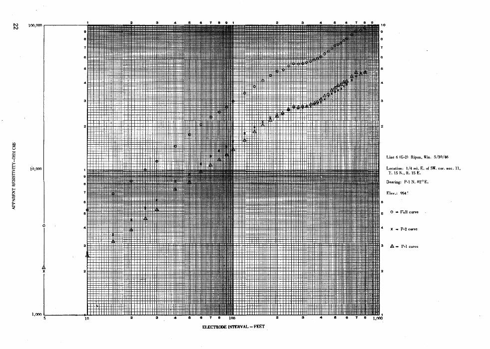
Line 6 (G-2) 5/30/46. 0. 25 mile east of southwest . corner of sec. 11, T. 15 N., R. 15 E. P1 - N. 82° E. Altitude 954 feet.
Electrical depth profile
Clay soil ........................ .
Depth (In feet)
0- 11.5
Dolomite, some shale and sandstone ... 11.5- 235
Shale, dolomite, sandstone. . . . . . . • • • 235 - 355
Pre-Cambrian rocks................ 355 - 800
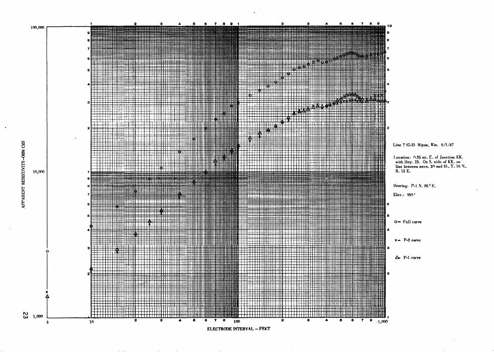
Line 7 (G-2) 6/1/47. 0. 35 mile east of junction of KK with Highway 23 along south side of KK and on line between sees. 30 and 31, T. 16 N., R. 15 E. P1 - N. 85° E. Altitude 939 feet.
Electrical depth profile
Clay soil .....•••..•••••••••••••••.
Depth (In feet)
0- 8. 5
Dolomite, some sandstone and shale ••• 8. 5- 335
Shale. . . • • • • • • • • • • • • • • • • • • • • . • • . • • 335 - 355
Sandstone......................... 355 - 585
Shale, some sandstone •..•. • . • • • • • • • . 585- 655
Pre-Cambrian rocks................ 655- 1, 000
The interpretation of depth to the pre-Cambrian rocks is from the P2 curve. It appears that the depth to pre-Cambrian is much greater on the P1 side of the profile.
Line 8 (G-2) 6/2/47. 0. 3 mile south from road KK em line between sees. 13 and 14, T. 15 N., R. 16 E. P1 - N. 3° W. Altitude 853 feet.
Electrical depth profile
Clay soil ..••...•...••••.••••••.••..
Depth (In feet)
0 - 6. 75

+1000
+ 850
+ 700
.... + 550 IIJ
1&.1 lo.
! + 400
00 IIJ Q :::) + 250 .... j: ..J Cl
+100
0
-50
- 200
RL-4
ss d
pe
·S
?
RL-2
~r·
sh d ss
RL-6 s
ld sh ss
-?
? 'pe
FtJr EXPLANATION 6ilil Figuril .J.
Figure 4. Cross section B- B' . Rosendale, Wisconsin
0 I 2 3 4 MILES
I I RL-6
I I l.t ss
RL-8
ITS RL-17 s
ip(:
For EXPLANATION 6tlt1 Fif1UrtJ .J
Figure 5. Cross section C- c• Rosendale-Fond du Lac, Wisconsin
0 I 2 3 4 MILES

Line 8 (G-2) 6/2/47 - Continued Dolomite; perhaps some till above. . • 3. 75 -107
Shale, dolomite, sandstone. . . . . . . . . 107 - 395
Pre-Cambrian rocks. . . . . . . . . . . . . . . 395 - 1, 000
The depth to pre-Cambrian is about 30 feet greater on the P2 side of the profile.
Line 9 (G-2). 0. 35 mile west of road I on east-west line of sec. 35, T. 16 N., R. 16 E. P1 - N. 86° E. Altitude 861 feet.
Electrical depth profile
Clay soil. ........................ .
Depth (In feet).
0 - 38
Till............................... 38 - 76
Dolomite, sandstone. . . . . . . . . . . . . . . . 76 - 1, 000
No certain indication of pre-Cambrian rocks. The last four or five observations indicate the presence of a layer having relatively low resistivity which might be slate.
Line 10 (G-2). 0. 35 mile south of road N and 1. 0 mile west of Highway 41 along west side of road, sec. 19, T. 16 N., R. 17 E. P1 - N. ff W. Altitude 814 feet.
Electrical depth profile Depth (In feet)
Clay soil. . . . • . • . . . • . . . . . . . . . . . . . . . . 0 - 15
Dolomite, perhaps some till above .. _. . 15 - 85
Dolomite and sandstone. . . . • . . . • . • . . • 85 - 1, 000
No indication of pre-Cambrian rocks. A change of material is indicated at about 650 - 700 feet and has
·lower resistivity than the layer above.
Line 11 (G-2) 6/4/47. · 0. 3 mile west of Highway 41 on road 000 along north line of sec. 9, T. 15 N. , R. 17 E. P 1 - N. 85 E. Altitude 757 feet.
Electrical depth profile
Clay soil ......•.•.•..••.•.••..•..•
Depth (In feet)
0 15
Till, probably considerable clay. . . . . 15 - 34
Dolomite, sandstone. . . . . . . . . . . . • . . . 34 - 385
Interpreted qualitatively because of some extraneous electrical inter-ference ........................... 385 - 1, 000
The material in the 385 - 825-foot zone has a generally low resistivity except for a somewhat higher resistivity in the 650 - 750-foot layer. The material in this zone is probably shale or siltstone interbedded with dolomite or sandstone. Based on the P 2 curve, mainly, the material below 825 - 875 feet appears to be of pre-Cambrian age.
Line 12 (G-2) 6/4/47. 0. 29 mile east of Highway 41 on north line of sec. 29, T. 16 N., R. 17 E. P 1 -N. 84 ° E. Altitude 788 feet.
9
Line 12 (G-2) 6/4/47- Continued Electrical depth profile Depth
(In feet) Soil, clay, drift. . . . . . . . . . . . . . . . . . . . . . 0 - 32
Dolomite. . . . . • . . . • . . • • • . . . . . . . . . • • . . 32 - 94
Dolomite, sandstone. . . . . . • • • • • . • . . . . . 94 - 420
Shale, siltstone, sandstone. . . . . . . . . . . 420 - 1, 000
There is a large variation in the depth to the lowest layer along the profile. The above-interpreted depth is from the F-curve but is controlled by the P 2 curve. The depth to the lowest layer from the interpretation of the P1 curve is :!: 700 feet. There is no indication of pre-Cambrian rocks.
Line 13 (G-2) 6/5/47. 0. 35 mile north of Highway 23 on center line of sec. 12, T. 16 N., R. 17 E. P1 -N. 7° E. Altitude 762 feet.
Electrical depth profile
Soil, clay ...••.....................
Depth (In feet)
0 - 11
Till .. .-.. . . . . . . . • • . . . . . . . . . . . . . . . . . . 11 - 86
Dolomite and sandstone.............. 86 - 850
Pre-Cambrian rocks. . . . • . . . . . . . . . . 850 - 1, 000
The depth to pre-Cambrian is less on the Pl side of the profile, being about 675 feet. The P 2 s1de of the profile has a depth of about 950 feet to preCambrian.
Line 14 (G-2) 6/5/47. On ~ld interurban roadbed and parallel to Milwaukee Railroad. 0. 3 mile south of north line of sec. 8, T. 16 N., R. 17 E. P 1 - N. 20• w. Altitude 799 feet.
Electrical depth profile Depth (In feet)
Soil, clay. . . • . . . • • . . . • • . . . • . . . . • . • . . 0 - 10
Clay .....••••.•............•.....•.. 10 - 16
Till, dolomite, sandstone .......•..... 16 - 392
Shale, siltstone, dolomite ...••....... 392 - 470
Sandstone and shale ...•....•......... 470 - 1, 000
There is a pronounced low-resistivity layer on the P1 side of the profile between 375 and 550 feet that is hardly apparent on the P 2 curve. Similarly, there is a low-resistivity layer on P 2 between 825 and 1, 000 feet that is not present on P 1. These layers are considered to be shale .or siltstone.
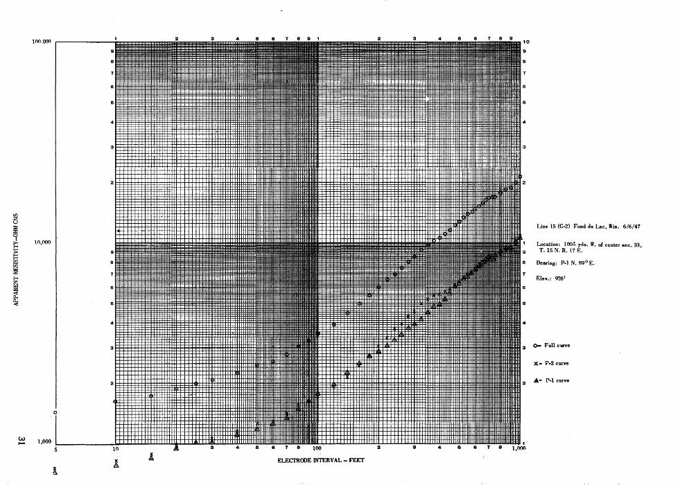
Line 15 (G-2) 6/6/47. About 100 yards west of center of sec. 33, T. 15 N., R. 17 E. P 1 - N. 89° E. Altitude 826 feet.
Electrical depth profile Depth (In feet)
Soil, clay........................... 0 - 10
Till ...••.••..•..................... 10 - 82

+ 850
+ 700
+ 550 .... 1&1 1&1 ...
+ 400
!
+ 250
+100
0
-50
-200
+1000
+ 850
+ 700
+ 550 .... 1&1 1&1 ....
+ 400 !
+ 250
+100
0
-50
-200
RL-10
d
d ss
c s
RL-9
d ss
c s
Figure 6. Cross section
0 2
RL-14 RL-12 s c s
c d
t d ss
d ss
fsh
·~·
sh ss sit sh ss
RL-8 c •
sh d IS
RL-18 s c
d ss
RL-20
d ..
For EXPLANATION s•• Figur• ~
o-o· Fond du Lac, Wisconsin 3 4 5 6 MILES
RL-15
RL-16
111:.~7 RL~/1
d ss
d ss sh
d ss
d ss
sh sit d or ss
'7
For EXPLANATION H• Figu,_ ~
Figure 7, Cross section E-E' Fond du Lac, Wisconsin
0 2 3 4 6 MILES
10
Line 15 (G-2) 6/6/47 - Continued
Dolomite, sandstone; shale or siltstone layer '710 - 770 feet .•..•...
Pre-Cambrian r-ocks; last three observations have a steep rise but are not adequate to make a good
Depth (In feet)
82- ;875
interpretation ..•..........• ." •..•.•• !:: 875-1,000
Line 16 (G-2) 6/6/47. 0. 3 mile south of county trunk highway FFF on center line oi sec. 4, T. 14 N., R. 17 E. P 1 - N. 0° E. Altitude 842 feet.
Electrical depth profile Depth (In feet).
Soil, clay.......................... . 0 - · 7. 5
Till. . . . . . . . . . . . . • . . . . . . . . . . . . . . . . • 7. 5- 192
Dolomite; sandstone. . . ... . . . • . • . • . . . . 192 - 1, 000
No indication of pre-Cambrian rocks.
Line 17 (G-2) 6/9/47. 0. 3 mile west of e~st line and on center line of sec. 17, T. 15 N., R. 17 E. P1 -N. 90° W. Altitude 790 feet.
Electrical depth profile
Soil, clay •.•.....•..•..•.••••.••••
Dolomite, sandstone •.•.••.••••••••
Depth (In feet)
0- 14
14- 750
Pre-Cambrian rocks. • . . . • . • • • • • . • • 750 - 1, 000
Line 18 (G-~. 0.? mile south of county trunk highway Ton west I e of sec. 19, T. 15 N., R. 17 E. P1- N. 10° w. Altitude 828 feet.:!:. 2 feet.
Electrical depth profile
Soil, clay ••••.•••••••.•••••••..•••
Depth (In feet)
0- 7. 25
Clay .•• : .•••.•.••.•.•••• :......... 7. 25- 13
Till............................... 13 - 55
Dolomite and sandstone............. 55- 1, 000
11
Line 19 (G-2) 6/10/47. 1, 500 feet northwest of overpass on Chicago ancrN'orthwestern Railroad in NWt sec. 26, T. 15 N., R. 17 E. Abandoned because of some unidentified electrical interference with the measurements.
Line 20 (G-2) 6/10/47. Along county hiqhway D, 0. 25 Iriiie north of county hiqhway FFF in sec. 6, T. 14 N., R. 17 E. P 1 - N. 25° E. Altitude 840 feet.
Electrical depth profile
Soil .. ...•.........•..•...........
Till, considerable coarse material .....
Till, some silty material •••.•••..••
Depth (In feet)
0- 4
4- 19
19- 252
Dolomite and sandstone. . • • . . . . • • • • • 252 - 1, 000
No indication of pre-Cambrian rocks.
Line 21(G-2) 6/11/47. Near Hartford, Wis. 0. 25 mile west of east lirie arid 0. 3 mile north of south line of sec. 29, T. 10 N., R. 18 E. P1 - N. 3° W. Altitude 1, 026 feet.
Electrical depth profile
Soil •••••••••••••••••••••••••••••
Clay ..........•.•....•.••..•.•..
Till .... .......•....•..•.•.•.•...
Limestone •.••••••.•••••••••••.••
Shale, dolomite •••••••• ~ •••.•. ~ .•
Depth (In feet)
0- 4
4- 8
8- 26
26- 195
195- .;.8oo
Pre-Cambrian rocks. • • • • • • . • . • • . • !:: 800 - 950
The indication from the P2 curve is ;. 750 feet and from the P 1 ;. 850 feet. · However, because of serious interference from a qround-return power line, the indications are considered uncertain.

..... 1\.)
b:j ----------- +400 ----
N I
I I
I I R I
I I
>I> 1- 1-z z :;)I:;)
818 ~~
I I ~~~ IAJO IAJZ
~~~ I
Utley I 0 I 0RL·I I
I
I EXPLANATION
• I Drilled well
I 0 Resistivity depth profile
I
R-13-E R-14-E
Bose from Wisconsin State Highway Mop, issued 1946
Figure 8.
eRL-7 +284'
R-15-E
Oakfield
R•J&•E
Contours on the pre-Cambrian surface from resistivity results 0 I 2 3 4 5- 6 MILES
Contour intervals 100 feet and 20 feet MTIIM q MIMI .lEA I.EI'El.
£'
R•I7•E
LAKE
WINNEBAGO
0RL·I9 __ NG
T 16 N
T IS N
T 14 N
H. Cecil Spicer, 1948

Well logs
Central Wisconsin Canneries Well Ripon, Wis. (NWtSWt sec. 22, T. 16 N. , R. 14 E. Aibtude about 940 feet)
Depth (in feet)
Drift............................. 0 - 25
Dolomite ................ ·. . . . . . . . . 25 - 65
Sandstone. . . . . . . . . . . . . . . . . . . . . . . . . 65 - 110
Shale. . . . . . . . . . . •. . . . . . . . . . . . . . . . . . 110 - 115
Dolomite. . . . . . . . . . . . . . . . . . . . . . . . . . 115 - 135
Sandstone ........................ . 135 - 145
Depth (in feet)
Stony till ......................... . 0 - 29
Dolomite ......................... . 29 -130
Sandstone and shale .....•...•....... 130 -145
Dolomite ...••.••.............•.... 145 - 175
Dolomite ........................ .
Sandstone and siltstone ........... .
Sandstone and siltstone ........... .
Shale ........................... .
Sandstone ....................... .
Shale ••.•.•••••.•.•.•.•••.•..•.••
Dolomite ....................... .
Sandstone .....•..................
Quartzite ....................•...
, , City well No . . 11, Fond duLac, Wis. (NEtSWtNWt sec. 10, T. 15 N. , R. 17 E. Altitude 755 feet)
Depth {in feet)
Red till. . . • . . . . • . . . . . . . . . . . . . . . . . . . 0 - 20 Sandstone ............ · ............ .
Stony till. . . • . . . . . . . . . . . . . . . . . . . . . . . 20 - 70 Dolomite ......................... .
Dolomite. . • . . . . • . . . . . . . . . . . . . . . . . . . 70 - 255 Sandstone ........................ .
Sandstone.......................... 255 - 350 Siltstone ......................... .
Red shale.......................... 350 - 415 Sandstone ........................ .
Test well {TW on map), Fond du Lac7
Wis. (NEtSEt sec. 9, T. 15 N., R. 1 E.)
Clay .............................. .
Depth {in feet)
0- 5
Red till...... . . . . . . . ... . . . . . . . . . . . . . 5 - 10
Stony till.......... . . . . . . . . . . . . . . . . . 10 - 50
Dolomite. . . . . . . . . . . . . . . . . . . . . . . . . . . 50 - 195
Sandstone. . . . . . . . . . . . . . . . . . . . . . . . . . 195 - 255
Shale. . . . . . . . . . . . . . . . . . . . . . . . . . . . . . 255 - 265
Sandstone ........................ .
Dolomite ......................... .
Sandstone ........................ .
Dolomite: ........................ .
Sandstone and siltstone ........................ .
Depth (in feet)
145 - 220
220 -280
280 -380
380 - 395
395 -495
Depth (in feet)
175-180
180-280
280 -440
440 -442
Depth (in feet}
415- 460
460 - 465
465 - 545
545 - 560
560 - 750
Depth (in feet)
310- 320
320 - 350
350 - 385
385 - 410
410 - 555
Dolomite. . . . . . . . . . . . . . . . . . . . . . . . . . . 265- 310 Quartzite. . . . . . . . . . . . • . . • . . . . • . . . . . 555 - 580
13

Test well, Galloway-West Co. (GW on map}, Fond duLac, Wis. (SEfNEt sec .. 16, T. 15 N., R. 17 E.)
Depth (in feet)
Till. ..• ·....••..•......•............ 0 - 31!
Dolomite. . . . . . • . . • . . . . . . . . . . . • . . . . . 31!- 205
Shale............................... 205-210
Sandstone ...•.•... ·. . . . . . .. • . . . . . . . . . . 210 - 345
Depth (in feet)
Dolomite. . . . . . . . . . . . . . . • . . . . . • • . . . . . 345 - 355
Sandstone. • . . . . . . . . • • . . . . • • . • • . . • • . . 355 - 435
Quartzite. • . • . . . • . . . . • . . • • • . • . • • • • . . 435 - 477
Corium Farm well (CF on map), Fond duLac, Wis. (NWtsec. 22, T. 15 N., R. 17 E.)
Depth (in feet)
Clay and hardpan. . . . . . . . . . . . . . . . . . . . . 0 - 80
Dolomite. . . . . . . • . . . . . . • . • . . . . . . . . . . . 80- 285
Sandstone and shale .......•...•....... 285 - 320
Dolomite. . . . . . • . . . . . . . . . . . . . . • . . . . . . 320 - 332!
Sandstone. . . . . . . . . . . . . . . . . . . . . . . • . . . 332!- 340
Depth (in feet)
Dolomite. . . . . . . . . . . . • . • . . . • . . • . . . . . 340 - 450
Sandstone. . . . . . . • . . • . . • . . • • . . . • . . . . 450 - 535
Conglomerate. . • . . . • • . . • . . • . . . . . . • . 535 - 550
Sandstone. . . . . . . . . • . . • . • . • . . • . . • . . . 550 - 555
Quartzite (? ). • • • • • . • . • • • • • • • • • • • • • • 555 +
Test well No. 4, Fond duLac, Wis. (NEtNEtNWt sec. 11, T. 15 N. , R. 17 E. Altitude 753 feet)
Depth (in feet)
Red clay ........•................... 0- 10
Till. . . . . . . . . . . . . . • . . . . . . . . . . . • . . . . . . 10 - 125
Dolomite. . . . . . . . . . . • • . . . . . • • • . . . . . . . 125 - 315
Sandstone ...•..... ; . . . . . . . . . . . . • . . . . 315 - 400
Siltstone, shale. . . . . . . . . . . . . . . . . . . . . 400 - 570
Sandstone ................•.......... 570- 645
Depth (in feet)
Siltstone ....... · • . . . . • . • • • • • . • . . . . . . 645 - 650
Sandstone. . . . . • . • . • . • . • . • . • • • •• . . . . 650 - 710
Siltstone........................... 710- 760
Sandstone. . . . . . • . • • . • • • . . . • . • . . • . . • 760 - 780
Red shale.......................... 780 - 817
Test welli McDermott Park (MP on map), Fond duLac, Wis. (NWfSET sec. 11, T. 15 N., R. 17 E. Altitude 765 feet)
Depth (in feet)
Clay and till......................... 0 - 50
Till. . . . . . . . . . . . . . . . . . . . . . . . . . . . . . . . . 50 - 142
Dolomite ............................ 142 - 325
Shale. . . . . . . . . . . . . . . . . . . . . . . . . . . . . . . 325 - 335
Sandstone ........................... 335 - 405
14
Depth (in feet)
Siltstone. . . . . . . . . . . . • . . . . . . . . . . . . . . 405 - 425
Sandstone .........•. · . . . . . • . . . . . . • . . 425 - 460
Siltstone........................... 460- 510
Dolomite........................... 510 - 540
Siltstone ........••...•...• , . . . • . • . . 540 - 585

City well No. 10, F~nd du Lac, Wis. (NE-tNW-tNWt sec. 11, T. 15 N. , R. 17 E. Altitude 755 feet)
Depth (in feet)
Red clay............................. 0 - 60
Clay. . . . . . . . . . . • . . . . • . . . . . . . . . . . . . . . . 60 - 100
Dolomite .........••...... _. . . . . . . . • . . 100 - 300
Sandstone ....•....•...•.•............ 300 - 465
Conglomerate .... ~ . . . . . . • . . . . . . . . . . . . 465 - 480
Depth (in feet)
Sandstone .. · ..............••.....•.•. ·. 480 - 490
Dolomite (no sample) .........•..•.... 490 - 500
Sandstone. . . . . . . . . • • . . . . . . . • . . . • . • . . 500 - 835
Slate .......•...•...•....•...•.•...•. 835 - 885
Well No. 2, North Fond duLac, Wis. {sec. 32, T. 16 N., R. 17 E.)
Depth (in feet)
Drift................................ 0 - 10
Till................................. 10 - 46
Dolomite. . . . • . . . . • • • . . . . . . . . . • • . . . . . 46 - 225
Sandstone. • . . . . . . . . • • . . . . . . . . . . . . . . . . 225 - 380
Shale. . . . . . . • . . . . . . . . . . . . . . . . . . . . . . . . 380 - 387
Depth (in feet)
Sandstone •...••.....•.••.......••..•• 387 - 400
Siltstone and shale •.........•.......•. 400 - 435
Conglomerate and chert ..•.•..••.....• 435 - 455
Sandstone. . . . . . . . . . . . . . . . . . . . . . . . . . . • 455 - 655
(siltstone 475 - 485)
Well No. 2, West Ice and Cold Storate Co. , Fond du Lac, Wis. (NWf NWt sec. 15, T. 1 N., R. 17 E.)
Depth (in feet)
Red clay............................. 0 - 10
Till................................. 10- 35
Depth (in feet)
Dolomite .......•............ , .--. • . • . • . 35 - 200
Cit~ well No. 12, Fond duLac, Wis. (NW-rSEt sec. 10, T. 15 N., R. 17 E.)
Depth (in feet)
Till....... . • • . • • . • . . . . • . . . . • . . . . . . . . 0 - 35
.Stony till. . . . . • . . . . . . . . . . . . . . . . . . . . . . 35 - 105
Dolomite. • . . . . . . . . . . . . • . . . . . . . . . . . . . 105 - 290
Sandstone. . . . . . . • • . . . . . . . . . . . . . . . . . . 290 - 430
Shale .•.........•. ~................. 430 -470
Depth (in feet)
Sandstone ...........•..•............. 470- 490
Dolomite. . . . . . . . . . . . . . . . . . . . . . . . . . . . . 490 - 495
Sandstone. . . . . . . . • . . . . . . . . . . . . . . . . . . . 495 - 520
Siltstone. . . . . . . . . . . . . . . . . • . . . . . . . . . . • 520 - 565
-Sandstone ........... ~ . . . . . . . . . . . . • . . . 565 -740
City well, Hartford, Wis. (NW-t sec. 16, T. 10 N., R. 18 E. Altitude 1010 feet)
Depth (in feet)
Glacial drift......................... 0 - 35
Limestone. . . . . . . . • . . . . . • • . . . . • . • . . . . 35 - 55
Shale. . . . . . . . . . . . . . . • . . . . . . . . . . . . . . . . 55 - 85
Limestone. . . . . .. . . . . . . . . . . • . . . . . . . . . . 85 - 100 15
Depth (in feet)
Shale. . . . . . . . . . . . . . . . . . . . . . . . . . . . . . . • 100 - 300
Limestone. . . . . . . . . . . . . . . • . . . . . . . . . . . 300 - 535
Sandstone ........•.•................• 535 - 550
Quartzite ....... : . • . . . . . . . . . . . . . . . . . • 550 - 735

City well No. 2 1 Hartford Wis. (T. 10 N. 1 R. 18 E. 1 sec. not given)
Depth (in feet)
(Old filled pit}. . . . . • • . . . . . . • . . . . . . . . . 0 - 66
Shale. . . • . • . . . . . • . . . . . . . . . . . . . . . . . . . 66 - 95
polomite ............... w • • • • • • • • • • • • 95 - 105
Shale ...•.•....................... ; . 105 - 115
Dolomite .. : .... ._.................... 115 - 130
Shale. . . . . . . . . . . . . . . . . . . . . . . . . . . . . . . 130 - 165 ·
16
Depth (in feet)
Dolomite. . . . • . . . • . • • . . • • • • • . . . . . . • . 165 - 100
Shale ......•..•.......•.....•..... ·. 190 - 280
Dolomite. . . . . . . . . . . . . . . . . . . . . . . . . . . 280 - 532
Quartzite. . . . . . . • . . . . . • . . . . . • . . • . . • . 532 -1370
Basalt or diabase .................... 1, 370-11 385
Quartzite.......................... 11 385-1,410

100,000 r---------i 2 3 4
~ u :::;;;
0 = ~ ~ 10,000
V'i t.l = f-< z t.l A = < X
~-
.....
....... 1,000 l' ' ~ t_l I I I I I I I I I I I I I I I I I I I I I I I I I I I I I I I J I I I I I I I '-I I I I I I'
6 8 T 8 9 1 2 3 4 IS 6 T 8 9
Line 1 (G-2) Ripon, Wis. 5/25/47
Location: NE. 1/4 35, T. 15 N., R. 13 E., On S. side of ~ilwaukee R. R. Branch opp. marker 6R on R. R.
Dearing: P-1 N. 41 1/2° E. Elev. 900'
Bearing: ·P-1 N. 41 1/2° E. Elev. 900 1
0 • Full curve
X - P-2 curve
A -.· P-1 curve
•

100!00(f - - - ~ - - - - - -=~~~§~~~;;~~~~=~~~~==§3=~~~~~~~~~s;;;;;;~~~~~;~g;§g;~~§~;§~~~~=~-~=··=::;· ...
llllllliUIIIilf91;11iiiiiii~IH~~Hiiiiilillllllllllllil;lliiiill!~:i~~~i!j; i~~:::: :~ ...... 9 111111UIIIiliiiiilllllllllllllllllll!lllllll;;;;;;;lilll!li;iii!;;;;;,::;,:;,, ;:· ~ . 00
~ u
~ I
~ ~
10,000
c::
~ a.. ~
1,000 10
EU"..C1'AADE OOERVAL -FEET
10
9
8
7
6
5
4
3
2
4
3
Line 2, Ripon, Wis.5/29/47
Location: 1/4 mi. N. E .• 1/4 mi. E. of the SW corner' sec.-35., T. 16 N .. R. 1!'; E., 2oor iJ. of Rosendale cannery ~ell \\. ~£ Rosend'sle. Wis.
[earing: ·P-1 N. 6°W.
Elev. 956 1
0 -Full curve
2 X - P-2 cur'lle
A - P-1 curve
4

100,~ ~------------~ 2 3 4
I HTIJH1111J1Htlllftlffiiiiiiiiiiiiiiiiiiiiiiiiiiiiii~IIIIIIIIIIIIIIIIIIIIIIIIIIIIIIIIIIIIIIIIII·~IIIIIIIIIIIIIIIIITI-Vl ::.. u
~ ~ ::: E= 10,~ Vl V) 9 r.:l g::
8 E-< z r.:l 7 g:: < c.. c.. <
0
!
...... 1.0 1,000 5 8 T 8 5 10
ELECTRODE INTERVAL-FEET
10
9
8
T
6
6
4
3
2
Line 3 (G-2) Ripon, Wis. 5/29/47
Loca~ion: l/4 mi. W. of center sec. 25,
a :T. 16 N., H. 15 E.
Dearing: P-1 N. !12° E.
Elev.: 1175'
6
6 0 - Full curve
4
X- P-2 curve
3 A..JP-1 curve

~ ·lOO,OOQ 9
8
6
5
4
3
2
I en :; u :; ::I: 0 I
~ ;:: ~ 10,000 en U)
I 9
(.:J CJ:: E-o a z (.:J CJ:: 7
<! 0..
~ I 6
6
4
2
1,000-· I 1
I I I I I I I I I I I I I I I I I II II I I I I I I I I I I I I I Ill I I !Ill
10" 2 3 4 6 6 7 8 100 2 3 4 5 6 7 8
ELECTRODEINTERVAt.-FEET
Line 4 (G-2) Ripon, Wis. 5/29/47
Loc-ation: l/4 mi. N. of center sec. 25,
T.l6 N., R. 15 E.
Dearing: P-1 N. 3 ° E.
E!ev.: R'75 1
0 -Full curVE"
X - P-2 curve
/1:;. -' P-l curve

en :::;;; u :::;;; = ~ ~ > E: en ~ ~ tl < c.. c.. <
1\) ......
100,000 .-------~"'"""'"1
e
B
15
4
3
2
I
10.000
I 9
B
7
I 6
15
4
2
5 10
2 3 4
2 3 4
15 6 7 e 9 1 2 3 4 ·15 6 7 B 9
Line 5 (G-2) Ripon, Wis. 5/30/45
L~a!ion: NW. 1/4 SE·. 1/4 sec. 14. T. 16 N., R. 14 F.. on Lietz's farm.
Dearing: P-1 N. 67° E.
Elev.: 941
0 - Full curve
X - P-2 curve
3 &_ _ P-1 curve
5 2 3 4 5 6 7
ELECTRODE INTERVAL-FEET
I'\) 100,000 - - - - - - - - - - - - 10 I'\)
9 9
8 8
T 7
6 6
5 5
4 4
3
21 I I I I I I I I. I ! tl' IIIII I I I I I I I IIIIIIIIIIIIIIIIIIIIIIIIIIIIIIIFFIIIIIIIIIIIIIIIIIIIIIIIIIIIIIIIIIIIIIIII I I I I I I 11111'1'11111111 I I I I I I lllllllllllllllllilllllllllllllllllllll.llllllllillllt'lll'liiliililll!!l2
I r.n ::;;; u 5§
Line 6 (G-2) Ripon, Wis. 5/30/46 'T ~ > 10,000 1 Location: 1/4 mi. E. of SW. cor. sec. 11,
E=: T. 15 N., R. 15 E. r.n 9 (i)
Ilearing: P-1 N. R2° E. C.:J 8 a:: E-< :z: 7 Elev.: 954 1 C.:J a:: < 0.. 6 6
~ 15 5 0 -Full curve
0 4 4 X - P-2 curve
31 I IiI II! IiI i 111111111 I I I I 111111111111111111111111111111111111111111111111111111111111111111!111111111 I I i I 1111111111111111 I I I I 11111111111111111111111111111111111111111111111111111111111111111111111111113 A- P-1 curve
X 2 2
1,000 I I I I I I I I I I I I I I I I I I I I Ill I I I I I I I I I I I If I I I I !ll!!llll
5 10 2 4 15 8 T 8 100 2 3 4 15 8 T B
ElECTRODE INTERVAL- FEET
en
~ :::;;;
9 ~ ~ ~ =:
~ =: < c.. c.. <
100,000
10,000
1\) w 1,000
0
X
5
2 3 4 5 8
9
8
T
6
6
4
3
9
a
7
6
6
4
3
10 2 3 4 s 8
T 8 9 1 2 3 4 5
T 8 100 2 3 4 s
ELECTRODE IN'I'ERVAL- FEI!:T
8 T
8 7
8 9
, 8 . 1,000
Li11e 7 (G-2) Ripon, Wis. 6/l/47
Location: 0.35 mi. E. of Junction KK. with Hwy. 23. On S. side of KK. on line between sees. 30 and 31, T. 16 1'\., R. 15 E.
Dearing: P-1 N. 85 ° E.
Elev.: 939 1
o- Full curve
x- P-2 curve
A- P-1 curve

1'\) 100,000 2 3 4 6
~ 9
8
T
6
s
4
3
2
I ~ u ::;;: = '? ~ > 10,000
9 E=:
I en
8
1i) t.J ex::
T E-<
~ ex:: <
6
I ~ <
s
4
' 3
2
5. 10
6 T 8 9 ' 2 3 4 6
100
ELECTRODE INTERVAL- FEET
6 T 8 9
Line R (G-2) Ripon. Wis. 6/2/47
Location: 0.3 mi. S. from County ttwy. KK. between sees. 13 and 14, T. 15 N., R. 16 E. on W. side of road.
Dearing: P-1 N. 3 ° \V.
Elev. 853 1
0- Full curve
X- P-2 curve
A- P-1 curve

·<I> a ::;;
~ ::: . ~ = E-<
~ c..· ~
1\)
10,000
10,000
U1 1,000 5. 10 2 3 4 15 • 7 8 2 3 4 15 8
ELECTRODE INTERVAL- FEET
7 8 1,000
Line 9 (G-2) Fond du Lac, Wis.
Location: 0.35 mi. W. of road· I along E-W road, center of sec. 35, T. '16 N., R. 16. E .
Bearing: P-1 N. 86 ° E.
Elev.: 861 1
o- Full cu.rve
x- P-2 curve
/]:,.. P-1 cu.rve

1'\) 0'1
Vl ::;:; u ::;:;
~ E=
f{!.l Vl t.:l = !.'-< z t.:l = < Q., c.. <
100,000
I
10,000
I I
1,000-5
2 3 4 15 --
9
8
7
6
6
4
3
2
9
8
7
6
15
3
10 4
6 7 8 9 1 2 3 4 15
100
ELECTRODE JN'I'fllV AL- FEET
6 7 8 9
Line 10 (G-2) Fond du Lac,JVis.
Location: 0.35 mi. S. of Rd. N 1 mi. W. of Hwy. 41 W. side of sec. 19 T. 16 N., R. 17 E.
Bearing: P-1 N. 50° W.
Elev.: 1!141
0- Full curve
X - P-2 curve
A- P-1 curve

r:n ::;; u ::;;
~ ~ ~ =::: E-< z t.l =::: < p..,
~
1\) ........
100,000
I
10,000
1,000
I
5
/A
9
8
7
6
6
4
3
2
9
8
7
6
6
4
3
2
10
10
Line 11 (G-2) Fond du Lac, Wis. 6/4/47
Location: 0.3 mi. W. of Hwy. 41 on Rd. 000. N. line of sec. 9, T. 15 N., R. 17 E.
Bearing: P-1 N. 85°E ..
Elev.: 7571
0- Full curve
X - P-2 curve
&. - P-1 curve
2 3 4 6 6 7 8 ' 100
ELECTRODE INTERVAL- FEET

1'\) JOO,OOO 10 00
9
8
7
6
5
4
3
I 2
llllllllllllllflfH II tfl1l111111111111111111111111111111111111111111111111111111111111111111111111IIIIflfillllllllfl fl m 111111111111-2
trJ :;; u :;; ::c c:r I I I I I I IIIIH±J !1111111 I I llllllllllllllllllllllllllllllllllllllllllllllllllllllllllllllllllllllllllllll I I II U Jlllllllllllll I f liiTIIIIIIIIIIIIIIIIIIIIIIIIIIIIIIIIIIIIIIIIIIIIIIIIIIIIIIIIIIHIIIIIIIIIIIIII Linel2 <G-2) N. Fond duLac, Wis. 6/4/47 >-t: >
Location: 0.29 mi. E. of Hwy 4.1 on N. lioe E= 10,000 1
~ 9 sec. 29, T. 16 N., R. 17 E. ~ a: 8 E-< Bearing: P-1 N. 84. 0 E. z
t:.J 7 a: <
Elev.: 788' 0.. 0.. 6 <
3
111- P-1 curve
.11111111111111111111111111111111111111111111111111111111111111111111111111111111111111111111111111111111111111111111111111111111111111111111111111111111111111111111111111.
1,000 5 10. 100
ELECTB.OOE INTERVAL - FEET

100,000 - -9
a
7
6
5
4
3
2
I ~ u :I;
6 :.!. F:: 10,000
::: t;;
I 9
~ ['-<
a
z w 7 cc; < 0.. I 0..
6
< 5
3
1 ~ 1,000
2 3 5 10
•
- - - . - - - - -
4 6 6 7 ., 100
ElECTRODE INTERVAL- FEET
- 10
5
4
3
2
Line 13 (G-2) Fond du Lac, Wis. 6/5/47
Location: 0.35 mi. N. of Hwy. 23 on center line sec. 12, T. 16 N., R. 17 E.
Bearing: P-1 N. 7° E.
Elev.: 762 1
0- Full curve
X - P-2 curve
A- P-1 curve

Vl
6 :;
~ ~ >
~ E-o z ll3 < c.. ~
w .....
100.000 - -9
e
7
6
6
4
3
2
10,000
9 I 8
I 8
I 6
4
3
2
1,000 J I I I I I I I I I I I I I I I I I I I 'i I I I !PI I I''!" I I !Ill I I~! I I Ill
5
l
10
X A
!
- - - - - -
100
ELECTRODE INTERVAL- FEET
10
9
e
7
6
6
4
3
2
9
Line 15 (G-2) Fond du Lac, \Vis. · 6/6/47
Location: 100.±. yds. IV. of center sec. 33, T. 15 N. R. 17 E.
Dearing: P-1 N. 89° E.
Elev.: 9261
o- Full curve
X- P-2 curve
A.- P-1 curve

w 100,000 N 9
8
7
6
6
4
3
2
I ~ u
~ cr ~ 10,000
9 ~
I 8
~ ~
7
a: !;; r..l
~ I 6 I:. 0.. <
6
4
I 3
I 0
I 2
A
1,000 \ e ~
01 I I I I I I I I I I I I I I I I I I 2 I I I I I I I I I~ I I I I I 1 1 1 141 1 1 1 11
15 100
Etm"RODE IN"'CRVA.f..- FEET
2 3 4 15 8
10
Line 16 (G-2) Fond du Lac, Wis. 6/6/47
Location: 0.3 mi. S. of County Hwy FFF in sec. 4, T. 14 N., R. 17 E.
llearing: P-1 N. 0° E.
Elev.: R42 1
0 - Full curve
X - P-2 curve
2 A - P-1 curve
l,(l(l()

~ u ~
== 0
~ > ~ ~ E-o z t.J
~ 0.. 0.. <
w w
100,000
10,000
I I
I.
1,000 ~
5
9
8
7
6
6
4
3
2
9
8
7
e
5
4
3
2
10 2 3 4 6 8 7 8 100 2 3 4 6 8 7 8
ELECTRODE INTERVAL- FEET
10
2
Line 17 (G-2) Fond du Lac, Wis. 6/9./47
Location: 0.3 mi. W. of E. Line on center line sec. 17, T. 15 N., R. 17 E.
Dearing: P-1, N. 90° W.
Elev.: 7901
0- Full curve
X- P-2 curve
A- P-1 curve

w. ~
~ u ::;; = cr ~ > ~ l'!.l en ;] E-o z r.J a:: < c.. c.. <
100,000
10,000
1,000
I
I I
0
" A
"' .. .. 9
a
7
6
5
4
3
2
9
a
7
6
5
4
3
2
2 3 4
g .. ' .. " 1 "' .. 4
8 100
ELECTRODE INTERVAL- FEET
6 6 7 a 9
Line 18 (G-2) Fond du Lac, Wis.
Location: 0.7 mi. S, of county Hwy. on W. line sec. 19, T. 15 N., R. 17 F..
Bearing: P-1 N. 10° W.
Elevation: 828!.±. 2 1
o- Full curve
X- P-2 curve
&.- P-1 curve

100,000 10
9 9
e e
7 7
6 6
5 5
4 4
3 3
21 I I I I I I IIi I· Ill' I' Ill I I I I 1111111111111111111111111111111111111111111111111111111111111111111111111111 I I I I I 1111111111111!1 I I I I IIIIIIIIIIIIIIIIIIIIIIIIIIIIIIIIIIIIIIIIIIIIIIIIIIIIIIIIIIIII:IIIIIIIIIUI2
I ~ u ::;;; = cr I I I IIIIIIIIIIIIIIIII!JI IIIIIIIIJIII!IIIIIIIIIIIIIIIIIIIIIIIlfl*llllllllllllllllllllllllll!lllll!ll!ll II 11111111 Ill! II IIIII I IIIIIIIJIIIIIIIIIIIIIIIItttttjjjjJtitttttlttttWlllttltltt- Line 19 (G-2) Fond duLac, Wis 6/10/47 i: > 1o;ooo E= Location: 1500 ft. N.W. of overpass on 5!3
C. & N.W. Ry. NWli sec. 26, T. 15 N., en 9 w
R. 17 E. r::c E- 6 z w e= <
7 Dearing: Not taken. c.. c.. 6 FHIHliTHfll-llllHBfHllfiiRtHIHIFFIHHHfff- r=r r-F I I I I I 1!1 I I -, ff!TJ I tlJ±HHJiiillllFIIHIIlllflllllllfHflfffiH±ItllttttfH Elev.: Not taken. <
511111 . IIIII iII Ill L1 I I llllllllllllllll!IJIUil llllllllilllllllllilllllllllllllllllllllllllllllil I I I I fTU!UlliiifTTIT I 11111111111111 IIIIIIIIIITffiiii!IIIIIIIIIIIIIIIIIIIIIIIII!Ht~llll!lllllllll 5 Given up due to a buried conductor along R.R. track.
4 4
3 3
o- Full curve 0
2
X- P-2 curve
8.- P-1 curve
I -~
w 0"1
~ u :::;;
~ > E: ~ w c::
~ w ~
~
"100,000
10,000
1,000
9
8
7
6
6
4
3
2
9
8
7
6
0 4
2
10 4 100 8 T 8
ElECTRODE INTERVAL- Ff.ET
Line 20 (G-2) Fond du Lac, Wis. 6/10/47
Location: County Hwy. D.,~ mi. N. of Couaty Hwy. FFF., sec. 6, T. 14 N., R. 17 F..
Bearing: Il-1 N. 25 ° E.
Elev.: 840'
0- Full curve
X - P-2 curve
A- P-1 curve

Vl ::;;. u :;: c:: '? >-E-o ;> F= ~:!a ~ c::: E-o
tJ c::: < 0.. ~·
w ""-J
100,000
I
I
10,000
1 0
I
A X I
1,000
5
10
9 9
e e
7 7
6 6
5 5
4 4
3 3
2Ftillll11fTI_I_DBI-Biltiii 2
UH±±ll!JlllJ I J I l Iii 1 U LJI ±JHHJliiJIITIIHIIHJHIIIllllllllllllll~llllH!UIIJllllllUIIlllllll I I lllllllJ±Jillill±UlliJilllliJ11HJ 111111111 !llllll!lllllllllllllllllllilllllllllllllllllllllllll Line 21 (G-2) Hartford, Wis. 6/11/47
~ : Location: ~mi. W. of E. line and 0.3 mi.
N. of S. line of sec. 29, T. 10 N., R. 1~ E.
Bearing: P-1 N. 3 ° W.
Elev.: 1026'
5 5
4 4
3 3 o- Full curve
X- P-2 curve
2 , 1 2
A- P-1 curve
10 2 3 4 15 8 7 8 100
ELECTRODE iNTERVAL- FEET