Investigating the Colorado River Simulation Model James Prairie Bureau of Reclamation.
34
Investigating the Colorado River Simulation Model James Prairie Bureau of Reclamation
-
Upload
charlotte-parker -
Category
Documents
-
view
239 -
download
0
Transcript of Investigating the Colorado River Simulation Model James Prairie Bureau of Reclamation.

Investigating the Colorado River Simulation Model
James Prairie
Bureau of Reclamation

Motivation
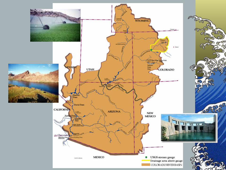
Colorado River Basin arid and semi-arid climates
irrigation demands for agriculture
Federal Water Pollution Control Act Amendments of 1972
“Law of the River” Minute No. 242 of the International Boundary and
Water Commission dated August 30, 1973
Colorado River Basin Salinity Control Act of 1974

Salinity Damages and Control Efforts
Damages are presently, aprox. $330 million/year
As of 1998 salinity control projects has removed an estimated 634 Ktons of salt from the river total expenditure through 1998 $426 million
Proposed projects will remove an additional 390 Ktons projects additional expenditure $170 million
Additional 453 Ktons of salinity controls needed by 2015
Data taken from Quality of Water, Progress Report 19, 1999 & Progress Report 20,2001

Seminar Outline
Motivation for researchInitial findings Working with a case studyNew salinity modeling techniquesExtending knowledge of our case studyCurrent Efforts
Recompute Natural flowVerify entire Colorado River Simulation Model
Future Research

Colorado River below Imperial Dam, Ariz-Calif
550
650
750
850
950
1940 1945 1950 1955 1960 1965 1970 1975 1980 1985 1990 1995
TD
S (
mg
/L)
0
10,000
20,000
30,000
40,000
Flo
w 1
,000
(ac
-ft)
TDS Flow


Research Objectives
Verify the data and calibrate the current model for both water quantity and water quality (total dissolved solids, or TDS)
Investigate the salinity methodologies currently used and improving them as necessary for future projection

Investigation of Colorado River Simulation Model
First developed in Fortran in 1970’sMoved to RiverWare in 1990’sRelies on Conservation of Mass for modeling
water quantity and,water quality (TDS).
Monthly Time StepRuns with operational rules to simulate
operational policies in the Colorado River Basin

Initial Findings
Data and Methodological InconsistencyNeed to improve current model techniques
Stochastic stream flow simulationEstimating natural saltAdding uncertainty
Working with a case studyDetailed investigation of current methodsDevelopment of new methods

USGS gauge 09072500
(Colorado River near Glenwood Springs, CO)
• Historic flow from 1906 - 95
• Historic salt from 1941 - 95
Case Study Area

USGS Salt Model
12 monthly regressionsbased on observed historic flow and salt
mass from water year 1941 to 1983historic salt = f (historic flow, several
development variables)
natural salt = f (natural flow, development variables set to zero)

Existing Salt Model Over-Prediction

New Modeling Techniques
Found problems with the current method to estimate natural salt in the upper basinCan we fix the problem?Alternate methods the estimate natural salt
with the available data

Statistical Nonparametric Model for Natural Salt Estimation
Based on calculated natural flow and natural salt mass from water year 1941-85 calculated natural flow = observed historic flow
+ total depletions
calculated natural salt = observed historic salt - salt added from agriculture+ salt removed with exports
Nonparametric regression (local regression)natural salt = f (natural flow)
Residual resampling

Local Regression
alpha = 0.3
or 27 neighbors
X
Y

x
y * e *
Residual Resampling
y = y* + e*
Y
X

Nonparametric Salt Model and USGS Salt Model

Natural Salt Mass from Nonparametric Salt Model and USGS Salt Model

USGS Salt Model and New Salt Model with K-NN Resampling Comparison

Comparison with Observed Historic Salt

Key Case Study Findings
The new nonparametric salt model removed the over-prediction seen with the USGS salt model
Provides uncertainty estimatesCan capture any arbitrary relationship
(linear or nonlinear)

Extending from Case Study
Applying case study results to entire modelImproved natural salt estimation modelImproved stochastic stream flow generationAddition of uncertainty analysis
Ensure flexible framework

Current Efforts
Recomputing natural flowLack of base dataUndocumented procedure
Upper versus Lower Basin
Inconsistency across time periodsInconsistent with future projection model

Natural Flow Development
Natural flow is a basic input for CRSSAddressing Data Inconsistencies
Recomputing natural flow from 1971-95
Natural Flow = Historic Flow
- Consumptive Uses and Losses
+/- Reservoir Regulation
Addressing Methodological InconsistenciesRiverWare model computes natural flow
Ensures consistency

Recomputing natural flow from 1971-95
Data required for natural flow modelHistoric USGS gauge data
29 gauges
Historic main-stem reservoir outflow and pool elevations12 main-stem reservoirs
Historic off-stream reservoir change in storage22 off-stream reservoirs
Consumptive uses and losses9 categories

Determining Natural Flow
saltflow
historic agriculture
historic exports
historic municipal and industrial
historic effects of off-stream
calculated natural flow estimated natural salt mass
simulated historic flow simulated historic salt mass
USGS stream gauge 09072500
consumptive useirrigatedlands
reservoir regulation
salt loadings
salt removedwith exports
agricultural


After Natural Flow Is Calculated
Extend new natural salt model throughout the 21 upper basin natural flow gauges Check natural flow and salt relationship
1941-1995; 1970-1995
Calculate natural flow for the lower basin Natural salt is back calculated as flow
Verify entire basin for flow and the lower basin for salt
Finally use more for a future projection
Apr-Jul 2003
Aug-Sep 2003
Oct-Nov 2003
Dec 2003

Future Research
Explore salinity relationship over both space and time
Incorporate new stochastic flow generation methods
Investigate land use change and the impacts on salinity levels
Explore the relationship between basin area and both flow and salinity

Acknowledgements
Dr. Balaji Rajagopalan, Dr. Terry Fulp, Dr. Edith Zagona for advising and support
Upper Colorado Regional Officeof the US Bureau of Reclamation, in particular Dave Trueman for funding and support
CADSWES personnel for use of their knowledge and computing facilities


Drainage AreaColorado River
Basin241,000 mi2
Upper Basin110,000 mi2
Case Study4,558 mi2