INVENTORY OF EXISTING AND PROPOSED...
9
Vol 5: EXISTING-PROPOSED TRAILS WMTH Corporation Buchanan Page 1 INVENTORY OF EXISTING AND PROPOSED TRAILS AN OVERVIEW OF EXISTING AND PROPOSED TRAILS IN BUCHANAN COUNTY ATV Trails. Potential (302) County: Buchanan Potential for developing motorized trails similar to West Virginia’s Hatfield and McCoy Trail System. A route has been GPS mapped from Elkhorn City Kentucky through Buchanan County ending at PeaPatch Virginia on the Virginia/West Virginia border. Another route that connects to this route is one that goes from Elkhorn City Kentucky down to Haysi Virginia then across to Vicey where it connects with the trail noted above and crosses into West Virginia at PeaPatch and continues east through War and Anawalt as the proposed southern route for the Great Eastern Trail. Recommendation: Continue to pursue completion of both these trails for public access. Bike Routes: TransAmerica Bicentennial Bike Route. Exists (302) Counties: Buchanan/Dickenson/Russell http://en.wikipedia.org/wiki/U.S._Bicycle_Route_76 Follows Hwy 80 at Elk Horn City near the Breaks into Virginia and continues eastward. Stewards are the Adventure Cycling Club. http://www.adventurecycling.org/ Recommendation: A review of the route should be conducted due to traffic changes over time to determine any safety issues or concerns. Once route is confirmed, website should be update and route promoted and marketed. Biking & Walking Trail: Michael D. Young Memorial Bicycle Trail. Exists County: Buchanan This is a 1.85 mile trail which starts in downtown Grundy and parallels Slate Creek and Slate Creek Road. Canoeing and Kayaking: Russell Fork River. Exists Counties: Buchanan/Dickenson http://www.virginia.org/site/description.asp?AttrID=15160 A tributary of the Big Sandy River, the Russell Fork River is a scenic series of rapids, pools and tortuous twists. World class whitewater rafting opportunities are available on the river running through the Breaks Canyon (Breaks Interstate Park) below the John Flannagan Dam four weekends in October when released from the dam create raftable water. Whitewater rating: Class III-V+, depending on the stretch of river. Ability exists to run easier rapids or harder rapids without running the other. Kayakers or rafters will enjoy this intense river. Russell Fork Whitewater outfitters offers day trips and assistance for families and groups. (276) 530-7044 Canoeing/Kayaking: Russell Fork Whitewater Adventures. Exists (VA Web) Outfitter for day trips on the Russell. http://www.virginia.org/site/description.asp?attrID=15195 Counties: Buchanan/Dickenson Russell Fork Whitewater Adventures offers visitors opportunity to run whitewater rapids of Class III-V+ . Outfitter works with individual or family’s needs and skills on river rafting.
Transcript of INVENTORY OF EXISTING AND PROPOSED...

Vol 5: EXISTING-PROPOSED TRAILS WMTH Corporation Buchanan Page 1
INVENTORY OF EXISTING AND PROPOSED TRAILS
AN OVERVIEW OF EXISTING AND PROPOSED TRAILS IN BUCHANAN COUNTY
ATV Trails. Potential (302) County: Buchanan Potential for developing motorized trails similar to West Virginia’s Hatfield and McCoy Trail System. A route has been GPS mapped from Elkhorn City Kentucky through Buchanan County ending at PeaPatch Virginia on the Virginia/West Virginia border.
Another route that connects to this route is one that goes from Elkhorn City Kentucky down to Haysi Virginia then across to Vicey where it connects with the trail noted above and crosses into West Virginia at PeaPatch and continues east through War and Anawalt as the proposed southern route for the Great Eastern Trail.
Recommendation: Continue to pursue completion of both these trails for public access. Bike Routes: TransAmerica Bicentennial Bike Route. Exists (302) Counties: Buchanan/Dickenson/Russell http://en.wikipedia.org/wiki/U.S._Bicycle_Route_76 Follows Hwy 80 at Elk Horn City near the Breaks into Virginia and continues eastward. Stewards are the Adventure Cycling Club. http://www.adventurecycling.org/ Recommendation: A review of the route should be conducted due to traffic changes over time to determine any safety issues or concerns. Once route is confirmed, website should be update and route promoted and marketed.
Biking & Walking Trail: Michael D. Young Memorial Bicycle Trail. Exists County: BuchananThis is a 1.85 mile trail which starts in downtown Grundy and parallels Slate Creek and Slate Creek Road.
Canoeing and Kayaking: Russell Fork River. Exists Counties: Buchanan/Dickenson http://www.virginia.org/site/description.asp?AttrID=15160A tributary of the Big Sandy River, the Russell Fork River is a scenic series of rapids, pools and tortuous twists. World class whitewater rafting opportunities are available on the river running through the Breaks Canyon (Breaks Interstate Park) below the John Flannagan Dam four weekends in October when released from the dam create raftable water.
Whitewater rating: Class III-V+, depending on the stretch of river. Ability exists to run easier rapids or harder rapids without running the other. Kayakers or rafters will enjoy this intense river. Russell Fork Whitewater outfitters offers day trips and assistance for families and groups. (276) 530-7044
Canoeing/Kayaking: Russell Fork Whitewater Adventures. Exists (VA Web)Outfitter for day trips on the Russell. http://www.virginia.org/site/description.asp?attrID=15195 Counties: Buchanan/DickensonRussell Fork Whitewater Adventures offers visitors opportunity to run whitewater rapids of Class III-V+ .Outfitter works with individual or family’s needs and skills on river rafting.

Vol 5: EXISTING-PROPOSED TRAILS WMTH Corporation Buchanan Page 2
INVENTORY OF EXISTING AND PROPOSED TRAILS
Greenway: Russell Fork Greenway. Proposed (88) County: Dickenson/Buchanan Russell Fork Greenway could connect the town of Haysi in Dickenson County to Buchanan County and on to Kentucky through Breaks Interstate Park. It is a non-motorized trail proposed to connect the breaks Interstate Park with Flannigan Dam along the banks of the Russell Fork River. Hiking Trails: Chestnut Ridge Nature Trail (at Breaks Interstate Park)See Dickenson County Inventory for Details Hiking Trails: Geological Trail (at Breaks Interstate Park). Exists See Dickenson County Inventory for Details
Hiking Trails: Lake Trail (at Breaks Interstate Park) Exists See Dickenson County Inventory for Details
Hiking Trails: Laurel Branch Trail (at Breaks Interstate Park). Exists See Dickenson County Inventory for Details
Hiking Trails: Overlook Trail (at Breaks Interstate Park) Exists See Dickenson County Inventory for Details
Hiking Trails: Prospector’s Trail (at Breaks Interstate Park) Exists See Dickenson County Inventory for Details
Hiking Trails: Ridge Trail (at Breaks Interstate Park) Exists See Dickenson County Inventory for Details
Hiking Trails: River Trail (at Breaks Interstate Park). Exists See Dickenson County Inventory for Details
Hiking Trails: Towers Overlook Trail (at Breaks Interstate Park) ExistsSee Dickenson County Inventory for Details Horse Trails: Breaks Interstate Park Horse trails Exists See Dickenson County – Breaks Interstate Inventory for Details Mountain Biking Trails: Breaks Interstate Mountain Biking Trails Exists (305) See Dickenson County Inventory for Details Riverfront Trail: Town of Grundy. In the works County: BuchananThe Town of Grundy is developing a Riverfront Trail along the Levisa Fork River and Route 83.

Vol 5: EXISTING-PROPOSED TRAILS WMTH Corporation Buchanan Page 3
INVENTORY OF EXISTING AND PROPOSED TRAILS
Statewide trunkline trails: Great Eastern Trail. In the works (288) Counties: Buchanan/Lee/Wise/Dickenson Great Eastern Trail - Major trunkline trail traverses the northern border of Virginia and connect with trails in both Alabama and New York. The southern route of the trail will go from Elkhorn City in KY south to the Town of Haysi then east through Dickenson and Buchanan County up to Pea Patch and into West Virginia through the towns of War and Anawalt.
Virginia Birding & Wildlife Trail: Lonesome Pine Loop VBWT Exists Counties: Buchanan/Wise/Dickenson http://www.dgif.virginia.gov/vbwt/loop.asp?trail=2&loop=MLP Virginia Birding & Wildlife Trail: Compton Mountain/Horn Mt VBWT Exists County: Buchanan http://www.virginia.org/site/description.asp?AttrID=51376
Virginia Birding & Wildlife Trail Poplar Gap/Sunset Hollow VBWT ExistsCounty: Buchanan http://www.virginia.org/site/description.asp?AttrID=51376 Poplar Gap/Sunset Hollow and the Breaks Interstate Park is shared with Dickenson County. These sites are part of the Lonesome Pine Loop. Each site provides mountaintop birding year round as well as Spring and Fall Migrants. These sites and the area between each are prime locations for migrating warblers as well as many other species.
OTHER NOTED INFORMATION OR ATTRACTIONS
Archaeological Survey: Portions are good to fair. (132) Architectural Survey: Portions are excellent and other portions are poor. (132) Biodiversity Ranking: None noted (247)
No Full time parks & recreation directors (267) State Park: Breaks Interstate Park Exists (305) Counties: Buchanan/Dickenson 4,600 acres with approx. 946 acres in Virginia. Known as the Grand Canyon of the South, the park has breathtaking views of the 5-mile long, one-quarter deep sandstone gorge carved by the Russell Fork over millions of years through Pine Mountain. Most of the trails are actually located either in Dickenson County or across the stateline in Kentucky. See Breaks Interstate Park Trail Map for details on trail locations.
Amenities: The Park has motor lodge, two-bedroom cottages and campground with electric, water and sewer hookups. There is a convention center, restaurant, visitor center and gift shop. Also swimming pool, picnicking, amphitheater, trails for hiking and mountain biking, boat dock and fishing on 12-acre Laurel Lake, whitewater rafting on Russell Fork and horseback riding.

Spearhead Trails
Southwest Virginia
BUCHANAN COUNTY‐ Existing Trails
Page 1
LET’S BUILD A TRAIL SYSTEM TOGETHER and REMEMBER Always respect private property rights by first obtaining permission
to access someone else’s land. Spearhead Trails
Southwest Virginia
BUCHANAN COUNTY‐ Existing Trails
Page 1
LET’S BUILD A TRAIL SYSTEM TOGETHER and REMEMBER Always respect private property rights by first obtaining permission
to access someone else’s land.
Spearhead Trails
Southwest Virginia
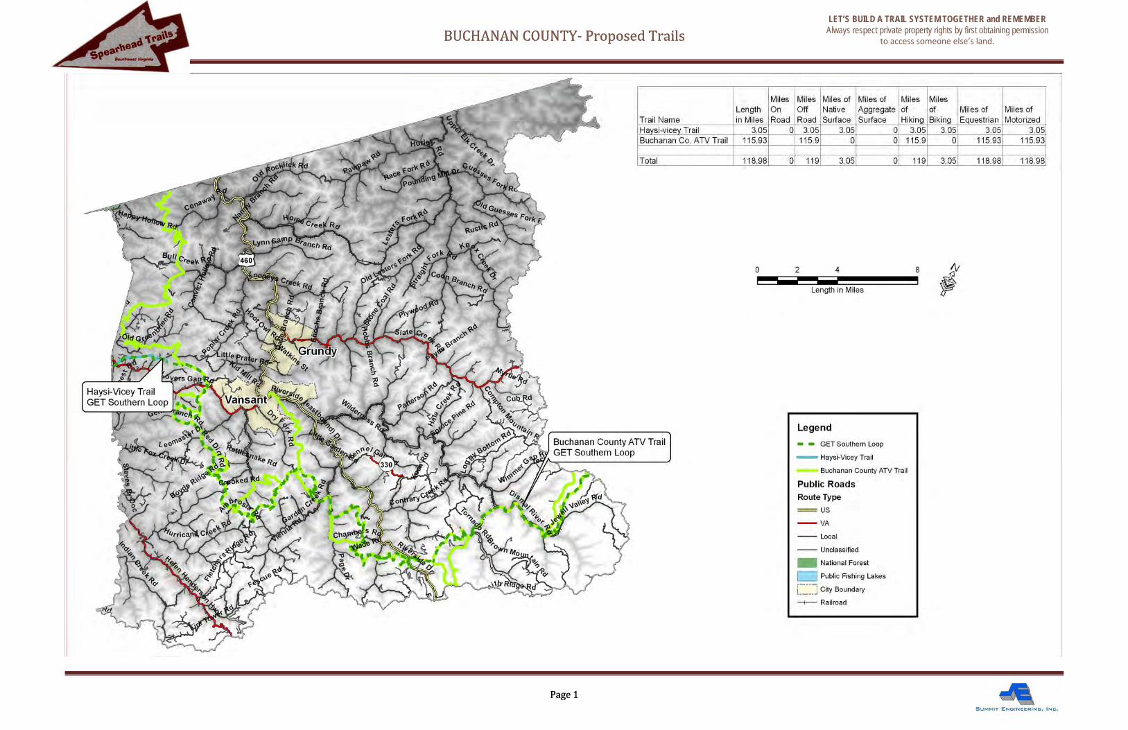
BUCHANAN COUNTY‐ Proposed Trails
Page 1
LET’S BUILD A TRAIL SYSTEM TOGETHER and REMEMBER Always respect private property rights by first obtaining permission
to access someone else’s land. Spearhead Trails
Southwest Virginia
BUCHANAN COUNTY‐ Proposed Trails
Page 1
LET’S BUILD A TRAIL SYSTEM TOGETHER and REMEMBER Always respect private property rights by first obtaining permission
to access someone else’s land.


Spearhead Trails
Southwest Virginia
GREAT EASTERN TRAIL – Proposed Route through Dickenson and Buchanan Counties Trailsrus.com/swvirginia
Page 1
National Forest
Public Fishing Lakes
City Boundary
Proposed Trail
Legend
Public RoadsRoute Type
US
VA
Local
Unclassified
Railroad
DESCRIPTION: The Great Eastern Trail (GET) is America’s newest long distance trail. It is modeled after the Appalachian Trail known as a premier wilderness experience for hikers and backpackers in the rugged mountains bordering Virginia and West Virginia.
LENGTH/TYPE OF TRAIL: The Great Eastern Trail will be a trail for all non‐motorized users. It is an approximately 1,800‐mile, long‐distance trail from Alabama to New York. Although sponsored by hiking clubs up and down the Eastern Seaboard, much of the GET, especially across Virginia, will be multi‐use.
PROPOSED SOUTHERN ROUTE THROUGH SW VIRGINIA: The route will go from Elkhorn City (or Pine Mountain Trail) in Kentucky, over to the VA side to the Russell Fork River, upstream to Haysi, follow the rail‐trail to Vicey, to South Gap/Poplar Gap to Grundy to Vansant to Whitewood following another rail‐trail to Peapatch at the Virginia/West Virginia stateline.
LEAD AGENCY/PARTNERS: Through SW Virginia, it is recommended that the Heart of the Appalachia organization serve as the lead agency.
CONNECTIONS AND DESTINATIONS: The southern route through SW Virginia will connect to a northern route through West Virginia and Kentucky, creating a looped trail system through three states.
IMMEDIATE ACTION: A proposal needs to be written and submitted to the GET Board of Directors.
1) Looking down on the proposed site for a trailhead and campground at Poplar Gap
3) Following the route of the old railroad near Whitewood makes an excellent route for the Great Eastern Trail.
2) Tunnel along route goes under the railroad tracks is a unique feature along the route.
4) Dave Kinder points out where the GET will cross into West Virginia from Virginia at Pea Patch.
A FEW OTHER UNIQUE FEATURES ALONG THE ROUTE

Spearhead Trails
Southwest Virginia
PROPOSED HAYSI‐VICEY TRAIL (DICKENSON/BUCHANAN COUNTY) LET’S BUILD A TRAIL SYSTEM TOGETHER and REMEMBER
Always respect private property rights by first obtaining permission to access someone else’s land.
Trailsrus.com/swvirginia
Page 1
LegendUS Bicycle Route 76
Haysi-Vicey Trail
Haysi-Breaks Trail
Buchanan County ATV Trail
Public RoadsRoute Type
US
VA
Local
City Boundary
Railroad
County Boundary
DESCRIPTION: The proposed Haysi‐Vicey Trail follows an existing trail originating in the Town of Haysi at the intersection of the Haysi‐Breaks Trail and the US Bicycle Route 76. The trail follows along route 83 and eventually heads away from the road and onto a power or gas line right‐of‐way, ending at an open area near the Town of Vicey which will serve as the Vicey Trailhead.
DESTINATION: This proposed trail will provide access from the Town of Haysi into Buchanan County, and more specifically, the proposed Buchanan County ATV Trail, which passes through the Vicey Trailhead for the proposed Haysi‐Vicey Trail. The addition of this trail to the system of trails in this area will provide much needed connectivity between the Buchanan County Trail system and the Dickenson County Trail System. LENGTH/TYPE OF TRAIL: The Proposed Haysi‐Vicey Trail is 7.6 miles in length and will serve as a connector between the towns of Haysi and Vicey. This will be a multi‐use trail for both motorized and nonmotorized users. CURRENT CONDITIONS: The trail route already exists. Due to its previous use as a gas road, the path is wide and easy to navigate whether on a horse, bike, walking or motorized vehicle. CONNECTIVITY: Proposed trail connects Haysi to Vicey, and intersect the 76 Bicycle Route. It is also part of the proposed southern route of the Great Eastern Trail System which runs from Elkhorn City KY through both Dickenson and Buchanan counties, intersecting with an existing ATV trail in Buchanan County before heading east into West Virginia.
1) The Town of Haysi
3) Right of way segment of the route.
2) Follows Route 83
4) Trailhead and possible connection to Buchanan
County ATV Trail
Spearhead Trails
Southwest Virginia
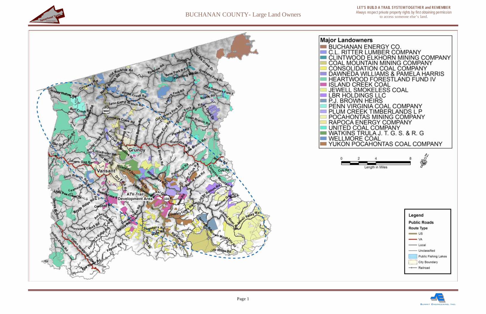
BUCHANAN COUNTY- Large Land Owners
Page 1
LET’S BUILD A TRAIL SYSTEM TOGETHER and REMEMBER Always respect private property rights by first obtaining permission
to access someone else’s land.