Remotesensing-04-00271_Environmental and Sensor Limitations in Optical Remote Sensing of Coral Reef

INTRODUCTORY
DIGITAL IMAGE PROCESSINGA Remote Sensing Perspective
John R. Jensen
University of South Carolina
* PEARSON SERIES IN
GEOGRAPHICINFORMATION SCIENCEKEITH C. CLARKE SERIES EDITOR

ContentsPreface XX
About the Author XXV
1 Remote Sensing and
Digital Image Processing
Overview 1
In Situ Data Collection 1
Remote Sensing Data Collection 3
Observations About Remote Sensing 4
Remote Sensing: Art and/or Science? 4
Information About an Object or Area 7
The Instrument (Sensor) 7
Distance: How Far Is Remote? 7
Remote Sensing Advantages and Limitations 7
Advantages 7
Limitations 8
The Remote Sensing Process 8
Statement of the Problem 8
Identification of In situ and Remote Sensing Data Requirements 9
Collateral Data Requirements 10
Remote Sensing Data Requirements 10
Remote Sensing Data Collection 10
Spectral Information and Resolution 12
Spatial Information and Resolution 13
Temporal Information and Resolution 16
Radiometric Information and Resolution 17
Polarization Information 17
Angular Information 18
Suborbital (Airborne) Remote Sensing Systems 20
Satellite Remote Sensing Systems 20
Remote Sensing Data Analysis 23
Analog (Visual) Image Processing 24
Digital Image Processing 24
Information Presentation 27
Earth Observation Economics 28
Remote Sensing/Digital Image Processing Careers in the Public and Private Sectors 29
Earth Resource Analysis Perspective 30
Book Organization 32
References 32

2 Remote Sensing Data
Collection
Overview 37
Analog (Hard-Copy) Image Digitization 37
Digital Image Terminology 37
Microdensitometer Digitization 38
Video Digitization 40
Linear and Area Array Charge-Coupled-Device Digitization 40
Digitized National Aerial Photography Program (NAPP) Data 42
Digitization Considerations 44
Digital Remote Sensor Data Collection 44
Multispectral Imaging Using Discrete Detectors and Scanning Mirrors 47
Multispectral Imaging Using Linear Arrays 48
Imaging Spectrometry Using Linear and Area Arrays 48
Airborne Digital Cameras 48
Satellite Analog and Digital Photographic Systems 48
Multispectral Imaging Using Discrete Detectors and Scanning Mirrors 48
Earth Resource Technology Satellites and Landsat 1-7 Sensor Systems 48
Landsat Multispectral Scanner 51
Landsat Thematic Mapper (TM) 53
Landsat 7 Enhanced Thematic Mapper Plus 57
NOAA Multispectral Scanner Sensors 63
Geostationary Operational Environmental Satellite (GOES) 64
Advanced Very High Resolution Radiometer 67
NOAA Suomi NPOESS Preparatory Project (NPP) 69
SeaStar Satellite and Sea-viewing Wide Field-of-view Sensor (SeaWiFS) 70
SeaWiFS 71
Multispectral Imaging Using Linear Arrays 73
NASA Earth Observing-1 (EO-1) Advanced Land Imager (ALI) 73
Advanced Land Imager (ALI) 73
NASA Landsat 8 (LDCM - Landsat Data Continuity Mission) 75
Orbital Land Imager 75
SPOT Sensor Systems 76
SPOT 1,2, and 3 76
SPOT 4 and 5 79
SPOT 6 and 7 81
Pleiades 81Pleiades 1A and 1B 81
Indian Remote Sensing Systems 82
IRS-1A,-1B,-1C, and-1D 83
CartoSat 84
ResourceSat 85
Korean Aerospace Research Institute (KARI) KOMPSATs 85
Astrium, Inc. Sentinel-2 87

viii CONTENTS
Advanced Spaceborne Thermal Emission and Reflection Radiometer (ASTER) 88
Multiangle Imaging Spectroradiometer (MISR) 89
GeoEye, Inc. (formerly Space Imaging, Inc.), IKONOS-2, GeoEye-1, GeoEye-2 90
IKONOS-1 and -2 90
GeoEye-1 and -2 91
EarthWatch/DigitalGlobe, Inc., QuickBird, WorldView-1, WorldView-2, WorldView-3 91
QuickBird 92
World-View-1,-2, and-3 92
ImageSat International, Inc., EROS A and EROS B 92
EROS A and EROS B 92
RapidEye, Inc. 93
RapidEye 93
DMC International Imaging, Ltd., SLIM-6 and NigeriaSat-2 93
SLIM-6 93
DMC-NigeriaSat-2 94
Imaging Spectrometry Using Linear and Area Arrays 94
NASA EO-1 Hyperion Hyperspectral Imager 96
Hyperion 96
NASA Airborne Visible/Infrared Imaging Spectrometer (AVIRIS) 96
AVIRIS 97
Moderate Resolution Imaging Spectrometer (MODIS) 97
NASA Hyperspectral Infrared Imager (HysplRI) 98
Itres, Inc. Compact Airborne Spectrographic Imager-1500 99
CASI-1500 99
SASI-600 99
MASI-600 99
TASI-600 100
HyVista, Inc., HyMap 100
Airborne Digital Cameras 101
Small-Format Digital Cameras 101
Medium-Format Digital Cameras 102
Leica Geosystems, Ag., RCD30 102
Large-Format Digital Cameras 102
Leica Geosystems, Ag., ADS80, Z/l Imaging DMC Aerial Photography 102
Microsoft, Inc., UltraCam Eagle 104
Digital Oblique Aerial Photography 105
Pictometry International, Inc., Oblique and Vertical Aerial Photography 105
Satellite Digital Frame Camera Systems 106
U.S. Space Shuttle Photography 106
Space Shuttle Analog Cameras 106
Space Shuttle and Space Station Digital Photography 107
Digital Image Data Formats 108
Band Interleaved by Pixel Format 108
Band Interleaved by Line Format 108
Band Sequential Format 108
Summary 108
References 108

CONTENTS ix
3 Digital Image ProcessingHardware and Software
Overview 111
Digital Image Processing Hardware Considerations 111
Central Processing Unit Considerations 112
History of Central Processing Units and Efficiency Measurement 112
Type of Computer 115
Personal Computers 115
Computer Workstations 115
Mainframe Computers 115
Read-Only Memory and Random Access Memory 116
Serial and Parallel Image Processing 116
Mode of Operation and User Interface 116
Mode of Operation 116
Interactive Graphical User Interface 119
Batch Processing 120
Computer Operating System and Compiler(s) 120
Input Devices 121
Output Devices 121
Data Storage and Archiving Considerations 122
Rapid Access Mass Storage 122
Archiving Considerations—Longevity 123
Computer Display Spatial and Color Resolution 123
Computer Screen Display Resolution 123
Computer Screen Color Resolution 125
Digital Image Processing Software Considerations 125
Image Processing Functions 126
Digital Image Processing Software 126
Multispectral Digital Image Processing Software 127
Geographic Object-based Image Analysis (GEOBIA) 127
Hyperspectral Digital Image Processing Software 127
LiDAR Digital Image Processing Software 127
RADAR Digital Image Processing Software 129
Photogrammetric Mapping Software 129
Change Detection 129
Integration of Digital Image Processing and GIS Functions 129
Cost 129
Open-Source Digital Image Processing Software 129
Open-Source Statistical Analysis Software that can be used for Digital Image Processing 129
Digital Image Processing and the National Spatial Data Infrastructure 130
References 130

X CONTENTS
4 Image Quality Assessmentand Statistical Evaluation
Overview 131
Image Processing Mathematical Notation 131
Sampling Theory 132
Types of Sampling 132
The Histogram and its Significance to Digital Image Processing 133
Metadata 134
Viewing Individual Pixel Values at Specific Locations or within a Geographic Area 137
Cursor Evaluation of Individual Pixel Brightness Values 137
Two- and Three-dimensional Evaluation of Pixel Brightness Values within a Geographic Area 138
Univariate Descriptive Image Statistics 138
Measure of Central Tendency in Remote Sensor Data 138
Measures of Dispersion 138
Measures of Distribution (Histogram) Asymmetry and Peak Sharpness 141
Multivariate Image Statistics 141
Covariance in Multiple Bands of Remote Sensor Data 142
Correlation between Multiple Bands of Remotely Sensed Data 142
Feature Space Plots 145
Geostatistical Analysis, Autocorrelation and Kriging Interpolation 145
Calculating Average Semivariance 148
Empirical Semivariogram 148
References 151

CONTENTS xi
5 Display Alternatives and
Scientific Visualization
Overview 153
Image Display Considerations 153
Black-and-White Hard-Copy Image Display 154
Line Printer/Plotter Brightness Maps 154
Laser or Ink-Jet Printer Brightness Maps 156
Temporary Video Image Display 156
Black-and-White and Color Brightness Maps 157
Image Data Format and Compression Scheme 157
Bitmapped Graphics 157
RGB Color Coordinate System 160
Color Look-Up Tables: 8-bit 160
Color Look-Up Tables: 24-bit 164
Color Composites 164
Optimum Index Factor 164
Sheffield Index 167
Independent Component Analysis-Based Fusion for Color Display of Hyperspectral Images 167
Merging (Fusing) Remotely Sensed Data 167
Simple Band Substitution 169
Color Space Transformation and Component Substitution 169
RGB to IHS Transformation and Back Again 169
Chromaticity Color Coordinate System and the Brovey Transformation 172
Principal Component Analysis (PCA), Independent Component Analysis (ICA), or
Gram-Schmidt Substitution 173
Pixel-by-Pixel Addition of High-Frequency Information 175
Fusion based on Regression Kriging 175
Smoothing Filter-Based Intensity Modulation Image Fusion 175
Length (Distance) Measurement 176
Linear Distance Measurement Based on the Pythagorean Theorem 176
Manhattan Distance Measurement 177
Perimeter, Area, and Shape Measurement 179
Perimeter Measurement 179
Area Measurement 180
Shape Measurement 181
References 181
xii CONTENTS
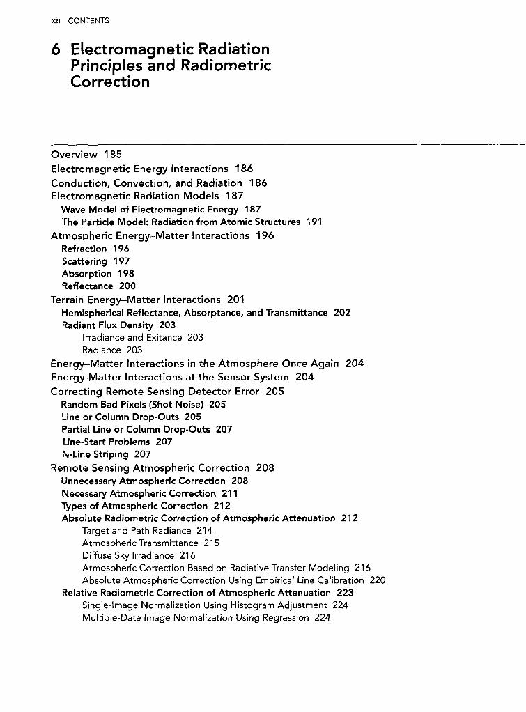
6 Electromagnetic Radiation
Principles and RadiometricCorrection
Overview 185
Electromagnetic Energy Interactions 186
Conduction, Convection, and Radiation 186
Electromagnetic Radiation Models 187
Wave Model of Electromagnetic Energy 187
The Particle Model: Radiation from Atomic Structures 191
Atmospheric Energy-Matter Interactions 196
Refraction 196
Scattering 197
Absorption 198
Reflectance 200
Terrain Energy-Matter Interactions 201
Hemispherical Reflectance, Absorptance, and Transmittance 202
Radiant Flux Density 203
Irradiance and Exitance 203
Radiance 203
Energy-Matter Interactions in the Atmosphere Once Again 204
Energy-Matter Interactions at the Sensor System 204
Correcting Remote Sensing Detector Error 205
Random Bad Pixels (Shot Noise) 205
Line or Column Drop-Outs 205
Partial Line or Column Drop-Outs 207
Line-Start Problems 207
N-Line Striping 207
Remote Sensing Atmospheric Correction 208
Unnecessary Atmospheric Correction 208
Necessary Atmospheric Correction 211
Types of Atmospheric Correction 212
Absolute Radiometric Correction of Atmospheric Attenuation 212
Target and Path Radiance 214
Atmospheric Transmittance 215
Diffuse Sky Irradiance 216
Atmospheric Correction Based on Radiative Transfer Modeling 216
Absolute Atmospheric Correction Using Empirical Line Calibration 220
Relative Radiometric Correction of Atmospheric Attenuation 223
Single-Image Normalization Using Histogram Adjustment 224
Multiple-Date Image Normalization Using Regression 224

Correcting for Slope and Aspect Effects 230
The Cosine Correction 230
The Minnaert Correction 231
A Statistical-Empirical Correction 231
The C Correction 231
Local Correlation Filter 232
References 232

Xiv CONTENTS
7 Geometric Correction
Internal and External Geometric Error 235
Internal Geometric Error 235
Image Offset (Skew) Caused by Earth Rotation Effects 235
Scanning System-Induced Variation in Ground Resolution Cell Size 236
Scanning System One-Dimensional Relief Displacement 239
Scanning System Tangential Scale Distortion 240
External Geometric Error 240
Altitude Changes 240
Attitude Changes 240
Ground Control Points 242
Types of Geometric Correction 242
Image-to-Map Rectification 242
Image-to-image Registration 243
Hybrid Approach to Image Rectification/Registration 243
Image-to-Map Geometric Rectification Logic 244
Spatial Interpolation Using Coordinate Transformations 244
Intensity Interpolation 250
An Example of Image-to-Map Rectification 252
Selecting an Appropriate Map Projection 252
Developable Surfaces used to Create Map Projections 253
Map Projection Characteristics 253
Cylindrical Map Projections 254
Azimuthal (Planar) Map Projections 260
Conical Map Projections 261
Other Projections and Coordinate Systems Useful for Image Rectification 263
Ground Control Point Collection 263
Determine Optimum Geometric Rectification Coefficients by Evaluating GCP Total RMSerror 263
Multiple Regression Coefficients Computation 264
Fill Output Matrix Using Spatial and Intensity Interpolation Resampling 267
Mosaicking 267
Mosaicking Rectified Images 267
Conclusion 271
References 271

8 Image Enhancement
CONTENTS XV
Overview 273
Image Reduction and Magnification 273
Image Reduction 273
Image Magnification 274
Transects (Spatial Profiles) 275
Spectral Profiles 279
Contrast Enhancement 282
Linear Contrast Enhancement 282
Minimum-Maximum Contrast Stretch 282
Percentage Linear and Standard Deviation Contrast Stretching 284
Piecewise Linear Contrast Stretch 286
Nonlinear Contrast Enhancement 286
Band Ratioing 288
Neighborhood Raster Operations 291
Qualitative Raster Neighborhood Modeling 292
Quantitative Raster Neighborhood Modeling 293
Spatial Filtering 293
Spatial Convolution Filtering 293
Low-frequency Filtering in the Spatial Domain 294
High-frequency Filtering in the Spatial Domain 297
Edge Enhancement in the Spatial Domain 298
The Fourier Transform 302
Spatial Filtering in Frequency Domain 306
Principal Components Analysis (PCA) 308
Vegetation Indices (VI) 314
Dominant Factors Controlling Leaf Reflectance 316
Visible Light Interaction with Pigments in the Palisade Mesophyll Cells 316
Near-Infrared Energy Interaction within the Spongy Mesophyll Cells 320
Middle-Infrared Energy Interaction with Water in the Spongy Mesophyll 323
Remote Sensing-Derived Vegetation Indices 325
Simple Ratio—SR 325
Normalized Difference Vegetation Index—NDVI 325
Kauth-Thomas Tasseled Cap Transformation 327
Normalized Difference Moisture or Water Index—NDMI or NDWI 332
Perpendicular Vegetation Index—PVI 333
Leaf Water Content Index—LWCI 333
Soil Adjusted Vegetation Index—SAVI 334
Atmospherically Resistant Vegetation Index—ARVI 335
Soil and Atmospherically Resistant Vegetation Index—SARVI 335
Aerosol Free Vegetation Index—AFRI 335
Enhanced Vegetation Index—EVI 336
Triangular Vegetation Index—TVI 336
Reduced Simple Ratio—RSR 336

xvi CONTENTS
Chlorophyll Absorption in Reflectance Index—CARI 337
Modified Chlorophyll Absorption in Reflectance Index—MTCARI 337
Optimized Soil-Adjusted Vegetation Index—OSAVI 337
Ratio TCARI/OSAVI 337
Visible Atmospherically Resistant Index—VARI 338
Normalized Difference Built-Up Index—NDBI 338
Vegetation Adjusted Nighttime Light (NTL) Urban Index—VANUI 338
Red-Edge Position Determination—REP 339
Photochemical Reflectance Index—PRI 339
NDVI and Cellulose Absorption Index—CAI 339
MERIS Terrestrial Chlorophyll Index—MTCI 339
Normalized Burn Ratio—NBR 340
Vegetation Suppression 340
Texture Transformations 340
First-Order Statistics in the Spatial Domain 340
Edge-Preserving Spectral-Smoothing (EPSS) Variance Texture 341
Conditional Variance Detection 342
Min-Max Texture Operator 343
Moran's / Spatial Autocorrelation as a Texture Measure 344
Second-Order Statistics in the Spatial Domain 345
Texture Units as Elements of a Texture Spectrum 348
Texture Statistics Based on the Semi-variogram 349
Landscape Ecology Metrics 350
Landscape Indicators and Patch Metrics 351
References 353

CONTENTS xvii
9 Thematic Information
Extraction: Pattern
Recognition
Overview 361
Introduction 361
Supervised Classification 362
Land-Use and Land-Cover Classification Schemes 364
American Planning Association Land-Based Classification Standard (LBCS) 365
USGS Anderson Land-Use/Land-Cover Classification System for Use with Remote Sensor Data 366
National Land Cover Database (NLCD) Classification System 367
NOAA Coastal Change Analysis Program (C-CAP) Classification Scheme 370
U.S. Department of the Interior Fish & Wildlife Service Classification of Wetlands and DeepwaterHabitats of the United States 371
U.S. National Vegetation Classification Standard (NVCS) 371
International Geosphere-Biosphere Program IGBP Land-Cover Classification System Modified for
the Creation of MODIS Land-Cover Type Products 374
Observations about Classification Schemes 375
Training Site Selection and Statistics Extraction 376
Selecting the Optimum Bands for Image Classification: Feature Selection 382
Graphic Methods of Feature Selection 382
Statistical Methods of Feature Selection 386
Select the Appropriate Classification Algorithm 393
Parallelepiped Classification Algorithm 393
Minimum Distance to Means Classification Algorithm 395
Nearest-Neighbor Classifiers 396
Maximum Likelihood Classification Algorithm 398
Unsupervised Classification 402
Unsupervised Classification Using the Chain Method 402
Pass 1: Cluster Building 403
Pass 2: Assignment of Pixels to One of the Cmax Clusters Using Minimum Distance Classification 404
Unsupervised Classification Using the ISODATA Method 406
ISODATA Initial Arbitrary Cluster Allocation 407
ISODATA First Iteration 408; Second to Mth Iteration 409
Unsupervised Cluster Busting 412
Fuzzy Classification 412
Object-Based Image Analysis (OBIA) Classification 413
Geographic Object-Based Image Analysis and Classification 414
OBIA Classification Considerations 420
Incorporating Ancillary Data in the Classification Process 421
Problems Associated with Ancillary Data 422
Approaches to Incorporating Ancillary Data to Improve Remote Sensing Classification Maps 422
Geographical Stratification 422
Classifier Operations 422
Post-Classification Sorting 423
References 423

xviii CONTENTS
10 Information Extraction
Using Artificial Intelligence
Overview 430
Expert Systems 430
Expert System User Interface 430
Creating the Knowledge Base 430
Algorithmic Approaches to Problem Solving 431
Heuristic Knowledge-Based Expert System Approaches to Problem Solving 431
The Knowledge Representation Process 432
Inference Engine 434
On-Line Databases 435
Expert Systems Applied to Remote Sensor Data 435
Decision-Tree Classification Based on Human-Derived Rules 435
Hypotheses to Be Tested 436
Rules (Variables) 436
Conditions 436
Inference Engine 436
Classification Based on Machine Learning Decision Trees and Regression Trees 436
Machine Learning 438
Decision-Tree Training 441
Decision-Tree Generation 441
From Decision Trees to Production Rules 441
Case Study 442
Advantages of Decision-Tree Classifiers 442
Random Forest Classifier 444
Support Vector Machines 444
Neural Networks 445
Components and Characteristics of a Typical Artificial Neural Network Used to Extract
Information from Remotely Sensed Data 446
Training an Artificial Neural Network 446
Testing (Classification) 447
Mathematics of the Artificial Neural Network 447
Feed Forward Multi-Layer Perceptron (MLP) Neural Network with Back Propagation (BP) 448
Kohonen's Self-Organizing Map (SOM) Neural Network 450
Fuzzy ARTMAP Neural Network 451
Advantages of Artificial Neural Networks 451
Limitations of Artificial Neural Networks 453
References 453

11 Information Extraction
Using Imaging Spectroscopy
Overview 459
Panchromatic, Multispectral and Hyperspectral Data Collection 459
Panchromatic 459
Multispectral 460
Hyperspectral 460
Satellite Hyperspectral Sensors 460
Airborne Optical Hyperspectral Sensors 460
Airborne Thermal-Infrared Hyperspectral Sensors 461
Steps to Extract Information from Hyperspectral Data 462
Select Study Area from Flight Lines 465
Initial Image Quality Assessment 465
Visual Examination of Hyperspectral Color Composite Images 465
Visual Individual Band Examination 465
Animation 465
Statistical Individual Band Examination 467
Radiometric Calibration 467
In Situ Data Collection 468
Absolute Atmospheric Correction 469
Radiative Transfer-Based Absolute Atmospheric Correction 469
Absolute Atmospheric Correction using Empirical Line Calibration 471
Geometric Correction of Hyperspectral Remote Sensor Data 471
Reducing the Dimensionality of Hyperspectral Data 472
Minimum Noise Fraction (MNF) Transformation 472
Endmember Determination: Locating the Spectrally Purest Pixels 474
Pixel Purity Index Mapping 475
n-Dimensional Endmember Visualization 475
Mapping and Matching using Hyperspectral Data 479
Spectral Angle Mapper 479
Subpixel Classification, Linear Spectral Unmixing or Spectral Mixture Analysis 480
Continuum Removal 484
Spectroscopic Library Matching Techniques 484
Machine Learning Analysis of Hyperspectral Data 487
Decision Tree Analysis of Hyperspectral Data 487
Support Vector Machine (SVM) Analysis of Hyperspectral Data 491
Selected Indices Useful for Hyperspectral Data Analysis 491
Reduced Simple Ratio 492
Normalized Difference Vegetation Index—NDVI 492
Hyperspectral Enhanced Vegetation Index—EVI 492
Yellowness Index—Yl 492
Physiological Reflectance Index—PRI 492

XX CONTENTS
Normalized Difference Water Index—NDWI 493
Linear Red-Edge Position—REP 493
Red-Edge Vegetation Stress Index (RVSI) 494
Crop Chlorophyll Content Prediction 494
Modified Chlorophyll Absorption Ratio Index (MCARI1) 494
Chlorophyll Index 494
Medium Resolution Imaging Spectrometer (MERIS) Terrestrial Chlorophyll Index (MTCI) 494
Derivative Spectroscopy 494
Narrow-Band Derivative-Based Vegetation Indices 495
Red-Edge Position Based on Derivative Ratio 496
References 496
CONTENTS XXi
12 Change Detection
Overview 501
Steps Required to Perform Change Detection 501
Specify the Thematic Attribute(s) or Indicator(s) of Interest 501
Specify the Change Detection Geographic Region of Interest (ROI) 501
Specify the Change Detection Time Period 502
Select an Appropriate Land-Use/Land-Cover Classification System 502
Select Hard (Crisp) and/or Soft (Fuzzy) Change Detection Logic 502
Select Per-pixel or Object-Based Change Detection (OBCD) 504
Remote Sensing System Change Detection Considerations 504
Temporal Resolution 504
Look Angle 505
Spatial Resolution 505
Spectral Resolution 505
Radiometric Resolution 506
Environmental/Developmental Considerations of Importance When Performing Change Detection 506
Atmospheric Conditions 506
Soil Moisture Conditions 507
Phenological Cycle Characteristics 508
Obscuration Considerations 511
Effects of Tidal Stage on Change Detection 511
Select the Most Appropriate Change Detection Algorithm 512
Binary Change Detection Algorithms Provide "Change/No-Change" Information 514
Analog "On-Screen" Visualization Change Detection 514
Esri, Inc., ChangeMatters® 516
Binary Change Detection Using Image Algebra 518
Image Differencing Change Detection 518
Image Algebra Band Ratioing Change Detection 519
Image Algebra Change Detection Using Statistical or Symmetric Thresholds 522
Image Algebra Change Detection Using Asymmetric Thresholds 522
Image Algebra Change Detection Using Moving Threshold Windows (MTW) 522
Multiple-Date Composite Image Change Detection 523
Supervised and Unsupervised Classification of Multiple-Date Composite Image to Detect Change 523
Principal Components Analysis (PCA) Composite Image Change Detection 523
MDA Information Systems, LLC, National Urban Change Indicator (NUCI)® 526
Continuous Change Detection and Classification (CCDC) using Landsat Data 528
Thematic "From-To" Change Detection Algorithms 529
Photogrammetric Change Detection 529
LiDARgrammetric Change Detection 531
Post-Classification Comparison Change Detection 532
Per-Pixel Post-Classification Comparison 533
OBIA Post-Classification Comparison 534
XXii CONTENTS
Neighborhood Correlation Image (NCI) Change Detection 538
Spectral Change Vector Analysis 542
Change Detection Using an Ancillary Data Source as Date 1 543
Change Detection Using a Binary Change Mask Applied to Date 2 544
Chi-Square Transformation Change Detection 545
Cross-Correlation Change Detection 545
Visual On-Screen Change Detection and Digitization 546
Hurricane Hugo Example 546
Hurricane Katrina Example 548
Aral Sea Example 548
National Land Use/Cover Database of China Example 548
Atmospheric Correction for Change Detection 548
When Atmospheric Correction Is Necessary 548
When Atmospheric Correction Is Unnecessary 551
Summary 551
References 551

CONTENTS xxiii
13 Remote Sensing-DerivedThematic Map AccuracyAssessment
Overview 557
Steps to Perform Accuracy Assessment 557
Sources of Error in Remote Sensing-Derived Thematic Maps 558
The Error Matrix 561
Training versus Ground Reference Test Information 562
Sample Size 563
Sample Size Based on Binomial Probability Theory 563
Sample Size Based on Multinomial Distribution 563
Sampling Design (Scheme) 564
Simple Random Sampling 565
Systematic Sampling 566
Stratified Random Sampling 566
Stratified Systematic Unaligned Sampling 567
Cluster Sampling 567
Obtaining Ground Reference Information at Locations Using a Response Design 568
Evaluation of Error Matrices 569
Descriptive Evaluation of Error Matrices 569
Discrete Multivariate Techniques Applied to the Error Matrix 570
Kappa Analysis 570
Fuzzification of the Error Matrix 571
Change Detection Map Accuracy Assessment 575
Assessing the Accuracy of the Individual Thematic Maps used in a Change Detection Study 576
Assessing the Accuracy of a "From-To" Change Detection Map 576
Response Design 576
Sampling Design 576
Analysis 577
Assessing the Accuracy of a Binary Change Detection Map 577
Assessing the Accuracy of an Object-Based Image Analysis (OBIA) Classification Map 578
Geostatistical Analysis in Support of Accuracy Assessment 578
Image Metadata and Lineage Information for Remote Sensing-Derived Products 579
Individual Image Metadata 579
Lineage of Remote Sensing-Derived Products 579
References 580

xxiv CONTENTS
Appendix:Sources of Imagery andOther Geospatial Information
Table of Contents 583
Federal Image and Geospatial Data Search Engines and Repositories 583
Commercial Image and Geospatial Data Search Engines and/or Repositories 583
Digital Elevation Data 583
Hydrography Data 583
Land Use/Land Cover and Biodiversity/Habitat Data 584
Population Demographic Data 584
Remote Sensor Data - Public 584
Remote Sensor Data - Commercial and International 584
Federal Geospatial Data Search Engines and Repositories 584-587
USGS EarthExplorer 584
USGS The National Map 585
USGS Global Visualization Viewer 586
Data.gov 587
Commercial Geospatial Data Search Engines and/or Repositories 587-591
Google, Inc., Google earth Search Engine 587
Microsoft, Inc., b'mg Search Engine 588
Esri, Inc., ArcGIS Online Map and Geoservices 589
Esri Map Services 589
Esri Image Services 590
Digital Elevation Data 591-593
GTOPO30 592
NED—National Elevation Dataset 592
Topographic-Bathymetric Information 592
Topographic Change Information 592
SRTM—Shuttle RADAR Topography Mission 592
ASTER Global Digital Elevation Model (GDEM V2) 593
NEXTMap World 30 DSM (Intermap, Inc.) 593
Hydrography Data 593-594
NHD—National Hydrography Dataset 594
EDNA—Elevation Derivatives for National Applications 594
Land Use/Land Cover and Biodiversity/Habitat Data 593, 595
NLCD—National Land Cover Database 1992, 2001, 2006, 2011 595
C-CAP—Coastal Change Analysis Program 595
GAP Analysis Program 595
NWI—National Wetlands Inventory 595
Road Network and Population Demographic Data 596-597
MAF/TIGER Line 597
2010 Census Population Demographics 597
LandScan Population Distribution Modeling 597

CONTENTS XXV
Remote Sensor Data—Public 596, 598-600
ASTER—Advanced Spaceborne Thermal Emission and Reflection Radiometer 598
AVHRR—Advanced Very High Resolution Radiometer 598
AVIRIS—Airborne/Visible Imaging Spectrometer 598
Declassified Satellite Imagery 598
DOQ—Digital Otthophoto Quadrangles 599
Landsat—MSS, TM, ETM+, Landsat 8 599
LiDAR—Light Detection and Ranging 599
MODIS—Moderate Resolution Imaging Spectrometer 599
NAIP—National Agriculture Imagery Program 600
Suomi—NPOESS Preparatory Project 600
Remote Sensor Data—Commercial and International 596, 600-602
CASI-1500 600
SASI-600 600
MASI-600 600
TASI-600 600
EROS A and B 600
GeoEye-1 and -2 601
HyMap 601
IKONOS-2 601
Indian IRS-1 A, -1B, -1C and -1D 601
Indian CartoSat-1, -2, -2A, -2B, and -3 601
ResourceSat-1 and -2 601
Korean KOMPSAT1-5 601
PICTOMETRY 601
Pleiades-1 and -2 602
QuickBird 602
RapidEye 602
Sentinel-2 602
SPOT 1-7 602
WorldView-1, -2, and -3 602
Index 603