Introduction to the Far North Land Use Strategy · An Introduction to the Far North Land Use...
15
An Introduction to the Far North Land Use Strategy December, 2013 Ministry of Natural Resources
Transcript of Introduction to the Far North Land Use Strategy · An Introduction to the Far North Land Use...

An Introduction to the Far North Land Use Strategy
December, 2013
Ministry of Natural Resources

An Introduction to the Far North Land Use Strategy 2
Table of Contents
PREFACE ............................................................................................................. 3
About the Far North ..................................................................................................................................... 3
Evolution of Land Use Planning in the Far North ..................................................................................... 4
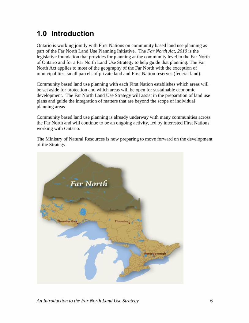
1.0 INTRODUCTION ........................................................................................ 6
Purpose of this Paper ................................................................................................................................... 7
2.0 COMMUNITY BASED LAND USE PLANNING AND THE STRATEGY ... 8
Community Based Land Use Planning ....................................................................................................... 8 Steps in the Planning Process: ................................................................................................................... 8
Far North Land Use Strategy ...................................................................................................................... 9
How does the Strategy Relate to Community Based Land Use Plans? ..................................................10
3.0 THINKING ABOUT THE STRATEGY ..................................................... 11
What will the Strategy Contain? ................................................................................................................11 Policy Guidance ........................................................................................................................................11 Categories of Land Use Designations and of Protected Area Designations .............................................12 Requirements and Processes for Amending Plans ....................................................................................12
What will Inform the Strategy’s Development? .......................................................................................13
4.0 MOVING FORWARD ............................................................................... 14
Steps in Developing the Far North Land Use Strategy: ...........................................................................14
How to get involved .....................................................................................................................................15

An Introduction to the Far North Land Use Strategy 3
Preface
About the Far North
The Far North of Ontario is home to 24,000 people living in 34 communities including
the municipalities of Pickle Lake and Moosonee. First Nations people make up more
than 90 per cent of the region’s population and live mainly in remote, fly-in communities.
Traditional languages spoken include Ojibway, Cree and Oji-Cree. First Nations people
in the Far North live as close to the land as anyone in North America, and they know and
rely on it. Many continue to pursue traditional activities, such as hunting, fishing and
trapping.
The Far North of Ontario is one of the world’s largest, most intact ecological systems.
The Far North covers 42 per cent of the province, spanning the width of Northern
Ontario, from Manitoba in the west to James Bay and Québec in the east. It encompasses
two distinct ecological regions: to the east are the bogs and fens of the Hudson Bay
Lowlands; to the west and south is the boreal forest of the Canadian Shield. By acting as
a carbon sink, the Far North’s forests, peatlands and wetlands play a key role in the
world’s fight against global climate change.
The Far North provides essential habitat for more than 200 sensitive species, including
species at risk like woodland caribou and wolverine, and Ontario’s only populations of
polar bears, beluga whales and snow geese. Millions of North American migratory birds
nest in the Far North. The Hudson Bay and James Bay coastlines provide internationally
important habitat for shorebirds.
While there is currently limited development in the Far North, there is vast natural
resource potential. There are two operating mines in the Far North, and ongoing mineral
exploration indicates significant mineral potential, particularly in the area known as the
“Ring of Fire.” Commercial forest potential has been estimated at 6 to 7% of the total
area of the Far North. There is also significant renewable energy potential (both wind and
water), although current provincial policy puts certain limitations on waterpower
development in the Far North. First Nations and resource industry have interest in
expanding infrastructure into the Far North including all-weather roads and electrical
transmission lines.

An Introduction to the Far North Land Use Strategy 4
Evolution of Land Use Planning in the Far North
Ontario and First Nations have long recognized the importance of land use planning,
which is a process of making decisions about how the land and the water will be used in
the future. The Far North of Ontario has never seen the kind of comprehensive land use
planning that has been done in the rest of Ontario.
First Nations and Ontario recognize that land use planning in the Far North requires a
different approach and different tools than elsewhere in the province. The1985 report of
the Royal Commission on the Northern Environment made important recommendations
about enhancing the participation of northerners, especially First Nations, in land use and
resource management decision making.
In the past, there have been a number of processes initiated by both First Nations and
Ontario to plan for the Far North. Although these processes did not result in plans
recognized by both Ontario and First Nations, they have contributed to the understanding
and evolution of planning.
In 2002, a joint community based land use planning approach was developed by First
Nations and Ontario as part of the Northern Boreal Initiative (NBI). The NBI was
established in response to several First Nations’ interests in commercial forestry just
north of the area that was then licenced for commercial forestry. This approach was
founded upon sharing responsibilities, applying local knowledge in decision making, and
full consultation. It established a promising foundation for joint efforts in planning and
decision making and led to the successful completion of the first community based land
use strategy in Ontario in 2006, the Whitefeather Forest Land Use Strategy.
In July, 2008, the Far North Land Use Planning Initiative was announced by Ontario,
extending this joint community based land use planning approach to all of the Far North.
The Far North Act, 2010, provides a legislative foundation to enable First Nations and
Ontario to jointly prepare and approve community based land use plans. The Act also
requires that a Far North Land Use Strategy be prepared and that joint planning teams
consider the Strategy as they develop their plans. The Strategy is intended to guide
planning and to help planning teams consider broad-scale matters.
Early discussions on the role of the Strategy were held with First Nations and
stakeholders between 2008 and 2009. Ontario worked with Nishnawbe Aski Nation
(NAN) and Tribal Council representatives through the Oski Machiitawin (Northern
Table) Land Use Planning Technical Table, including dialogue on principles and
processes to guide land use planning in the Far North. These discussions helped inform
the drafting of the relevant sections of the Far North Act.
The Ministry of Natural Resources also established a Far North Advisory Council and a
Far North Science Advisory Panel to provide advice to government on land use planning
in the Far North. The Advisory Council recommended to government the need to ensure
that community plans have regard for broader regional objectives that transcend
traditional land use areas. The Science Panel provided advice on current and emerging

An Introduction to the Far North Land Use Strategy 5
pressures on natural resources, wildlife and ecology in the Far North, and identified
science and information gaps. The panel’s final report “Science for a Changing Far
North” provides a valuable source of scientific information for both First Nations and
Ontario as they work together on developing a Far North Land Use Strategy.
An Introduction to the Far North Land Use Strategy 6
1.0 Introduction
Ontario is working jointly with First Nations on community based land use planning as
part of the Far North Land Use Planning Initiative. The Far North Act, 2010 is the
legislative foundation that provides for planning at the community level in the Far North
of Ontario and for a Far North Land Use Strategy to help guide that planning. The Far
North Act applies to most of the geography of the Far North with the exception of
municipalities, small parcels of private land and First Nation reserves (federal land).
Community based land use planning with each First Nation establishes which areas will
be set aside for protection and which areas will be open for sustainable economic
development. The Far North Land Use Strategy will assist in the preparation of land use
plans and guide the integration of matters that are beyond the scope of individual
planning areas.
Community based land use planning is already underway with many communities across
the Far North and will continue to be an ongoing activity, led by interested First Nations
working with Ontario.
The Ministry of Natural Resources is now preparing to move forward on the development
of the Strategy.

An Introduction to the Far North Land Use Strategy 7
Purpose of this Paper
The purpose of this paper is to provide:
Background on community based land use planning and the Far North
Land Use Strategy
An introduction to the Strategy – the concepts, components and intent and
how it will relate to community based land use plans
Next steps in the development of the Strategy and opportunities for
participation

An Introduction to the Far North Land Use Strategy 8
2.0 Community Based Land Use Planning and the Strategy
Community based land use plans and the Far North Land Use Strategy are both important
components of the Far North Land Use Planning Initiative, each having a different
purpose but working together in a complementary way. A brief description of each and
an explanation of how they work together follow.
Community Based Land Use Planning
The Ministry of Natural Resources is working jointly with First Nations in the Far North
to develop community based land use plans (plans).
Community based land use planning is a process to describe what land use activities may
take place and where. Plans will identify areas that will be dedicated to protection, and
areas that are suitable for sustainable economic development opportunities such as
forestry, mining and renewable energy. Aboriginal traditional knowledge and science-
based information and knowledge inform and support the development of a plan. Once a
land use plan is in place, activities on the landscape must be consistent with the plan’s
land use designations.
Steps in the Planning Process:
First Nations initiate engagement in planning process.
Establish a joint planning team (First Nation and MNR).
Collect background information and map traditional knowledge and values.
Develop a Terms of Reference, to be jointly approved by the First Nation and
Ontario, that: o sets out the process to complete a plan and provides guidance for
establishing a planning area.
Provide opportunity for public participation in the planning process, including
posting on the Environmental Registry.
Set out objectives that the plan will address and describe land and resource
opportunities in the planning area.
Jointly prepare a Draft Plan which includes proposed land use and protected area
designations (zoning) and provide opportunity for public comment, including
posting on the Environmental Registry.
Jointly prepare the final Community Based Land Use Plan to be jointly approved
by the First Nation and Ontario.
Post final plan on the Internet and Environmental Registry

An Introduction to the Far North Land Use Strategy 9
To date, five communities have completed community based land use plans (Pikangikum,
Cat Lake, Slate Falls, Pauingassi, and Little Grand Rapids). The plans have been jointly
approved by the First Nation(s) and the Minister of Natural Resources under the Far
North Act. In addition, approved Terms of Reference are in place for Deer Lake,
Eabametoong and Mishkeegogamang First Nations
Far North Land Use Strategy
Under the Far North Act, 2010, the Minister of Natural Resources must ensure that a Far
North Land Use Strategy is prepared.
The Strategy will provide policy guidance that joint planning teams can draw from to
help consider the Far North as a whole as they develop their plans. This policy guidance
will recommend approaches to considering matters of common interest across the Far

An Introduction to the Far North Land Use Strategy 10
North, such as watersheds, all-weather roads and transmission corridors, caribou habitat
and migration routes, and climate change. The Strategy will also include policies on:
categories of land use designations;
categories of protected area designations; and
the process and requirements for amending community based land use plans.
As the Far North Land Use Strategy is developed, joint planning teams must take it into
account as they prepare community based land use plans.
Further information on what the Strategy will contain is found in section 3.
How does the Strategy Relate to Community Based Land Use Plans?
While joint First Nation-Ontario planning teams must take the Strategy into account
when preparing plans, decisions on land use and protected area designations remain with
the joint planning team at the community level. . Joint planning teams prepare
community based land use plans that consider both community and provincial interests,
building a shared understanding of desired outcomes. MNR is Ontario’s representative
on the joint planning team, and is responsible for bringing forward provincial interests in
both protection and development.
The diagram below shows the relationship between the Strategy and community based
land use plans.

An Introduction to the Far North Land Use Strategy 11
3.0 Thinking about the Strategy
What will the Strategy Contain?
The Far North Land Use Strategy will describe and provide policy guidance to support
planning on matters of common interest across the Far North.
The Strategy will also include policies relating to categories of land use designations and
to categories of protected area designations. Additionally, the Strategy will include
requirements and processes for amending community based land use plans.
The next sections outline the major components of the Strategy.
Policy Guidance
Policy guidance on cultural, social, environmental and economic interests would assist
planning teams in considering broad-scale interests while developing individual
community based land use plans. The Act identifies a number of policy topics that could
be included in the Far North Land Use Strategy:
Cultural and heritage values
Ecological systems, processes and functions, including considerations for
cumulative effects and for climate change adaptation and mitigation
The interconnectedness of protected areas
Biological diversity
Areas of natural resource value for potential economic development
Electricity transmission, roads and other infrastructure
Tourism
As an example, policy guidance on protected area design could suggest that joint
planning teams consider:
The size and scale of protected areas, and the importance of their
interconnectedness across the landscape.
Cultural, ecological and geological values or features that should be protected
from development.

An Introduction to the Far North Land Use Strategy 12
Land use direction for adjacent lands that could complement protection of these
features.
Features that extend across large areas (i.e., cross more than one planning area).
Such features could include waterways and wildlife migration routes.
Existing and potential transportation and other infrastructure corridors and
consideration of the need for crossing of protected areas.
Features in neighbouring communities, and how protected areas could be linked
to those to provide for connectedness.
The policy guidance in the Strategy may eventually become more formalized through
“policy statements” should a First Nations-Ontario Joint Body be established under the
Far North Act. If a Joint Body is established, policy statements could be recommended
to the Minister and be issued with approval of Cabinet.
Categories of Land Use Designations and of Protected Area Designations
The Strategy will also contain policies related to categories of land use designations and
to categories of protected area designations. These policies will describe types of land
use designations that could be used in community based land use plans and the land uses
and activities that would be permitted or not permitted in a particular land use
designation. Land use designations in already completed community based land use
plans could help inform development of broad policy on this topic.
Categories of “protected areas” would be developed to be in keeping with First Nations
understanding of protection and will be built on a shared understanding of “protection”
and “protected areas”. Approaches to land use and protected area designations used
elsewhere in Ontario and in other jurisdictions could also provide examples of potential
approaches.
Requirements and Processes for Amending Plans
The Strategy will contain guidance on amending approved plans.
Broad direction on plan amendments is already provided in Sections 10 (1) and (2) of the
Far North Act. The Act states that either the First Nation or Minister that have approved
a plan may propose an amendment to the plan. It also requires that the objectives of the
Act and the Strategy must be taken into account in developing the amendment, and sets
out the mandatory contents of the plan amendment. As with the original plan, the
amendment must be approved by both the First Nation and the Minister.
The Strategy would build on this broad direction by providing further guidance regarding
the process for preparing and consulting on plan amendments.

An Introduction to the Far North Land Use Strategy 13
What will Inform the Strategy’s Development?
First Nations knowledge and experiences are key to the development of the Strategy. As
we move forward to develop the Strategy we will be engaging First Nation communities
to work with us and to share their knowledge and perspectives. Input from the public
and stakeholders is also important and we welcome comments and input at each stage.
In addition, the Province and First Nations now have over 15 years of experience with
community based land use planning; this experience will be instrumental to the Strategy’s
development. In approved plans to date for example, planning teams have provided
strategic direction that enables desired economic development opportunities while
ensuring protection of values. Direction sets out guidance on how desired activities
would take place, for example planning for access in a way that considers the desire to
also maintain areas of remoteness.
The Strategy could provide a synopsis of this type of guidance for the benefit of other
planning teams.
The objectives for land use planning set out in the Far North Act will be taken into
account in the development of the Strategy. These objectives are:
1. A significant role for First Nations in the planning.
2. The protection of areas of cultural value in the Far North and the protection of
ecological systems in the Far North by including at least 225,000 square
kilometres of the Far North in an interconnected network of protected areas
designated in community based land use plans.
3. The maintenance of biological diversity, ecological processes and ecological
functions, including the storage and sequestration of carbon in the Far North.
4. Enabling sustainable economic development that benefits the First Nations.
Existing provincial policy in areas such as biodiversity, climate change, and natural
resource development will also help inform the development of the Far North Land Use
Strategy.

An Introduction to the Far North Land Use Strategy 14
4.0 Moving Forward
Steps in Developing the Far North Land Use Strategy:
The Strategy is a key component of the Far North Land Use Planning Initiative. MNR
looks forward to working with First Nations and seeking input from stakeholders and the
general public to develop the Strategy. In addition to this introductory paper, further
postings will be made on the Environmental Registry to seek input as the Far North Land
Use Strategy is developed. This paper represents Stage 1, and further planned Stages are
set out in detail below.
Stage 1: Introduction to the Far North Land Use Strategy (Fall 2013)
- Provides overview of the Strategy’s contents and how it will guide/support
planning
- Serves as the “Invitation to Participate” in the development of the Strategy
- Posted on the Environmental Registry (ER) for comment
Stage 2: Discussion Paper (Winter 2014 - Summer 2014)
- MNR will prepare a preliminary Discussion Paper to seek input on different
planning topics that could be included in the Strategy.
- First Nations will be engaged to share their knowledge and perspectives to guide
the development of a Draft Strategy.
- Discussion paper will be posted on the Environmental Registry for comment and
input.
- Additional opportunities for engagement with stakeholders will also be provided
Stage 3: Draft Strategy (Fall 2014)
- Draft Strategy will be posted on the ER for comment
- MNR will continue to work with First Nations and seek input from stakeholders
Stage 4: Final Far North Land Use Strategy (Winter 2014/15)
- MNR will post the Final Strategy on the ER as a decision and make it available
on the Internet
- The Strategy will include a timeline for future review

An Introduction to the Far North Land Use Strategy 15
How to get involved
If you are interested in being added to a mailing list to receive information on the
development of the Far North Land Use Strategy, please send an email to:
If you would like to request a meeting to discuss the Strategy, your request can be
emailed to: [email protected]
You can submit comments on the Environmental Registry posting.
Feedback
Written comments can be submitted to:
Far North Branch
Ministry of Natural Resources
77 Grenville St., 5th Floor
Toronto, ON
M5S 1B3
Written comments can also be submitted on the Environmental Registry posting:
www.ebr.gov.on.ca
Additional Links
Please go to http://www.ontario.ca/farnorth for more information on the Far North Land
Use Planning Initiative.