


Petra Miku š DHMZ, Croatia, EUMeTrain project [email protected]
Marine Forecasting Course - 2013 [email protected]
Introduction to
Ship Rout(e)ing
Dr. Thomas Bruns
Deutscher Wetterdienst
Hamburg
Marine Forecasting Course - 2013

Marine Forecasting Course - 2013 [email protected] 2
Outline
A short History of Ship Routing
Ocean Waves and other Hazards
Climate & Weather Navigation
Route Optimization
Ship Performance
Onboard & Shore-based Routing

Marine Forecasting Course - 2013 [email protected] 3
1855 Maury published his Sailing Directions Read More : http://www.britannica.com/EBchecked/topic/516637/Sailing-Directions
1912 RMS Titanic sank on April 15th
1914 "International Convention for the
Safety Of Life At Sea" was initiated.
1955 First commercial Ship Routing Services
in USA
1959 Foundation of the „International
Maritime Organization“ (IMO)
1959 Ship Routing Service launched at
German Weather Service (DWD)
1974 SOLAS 74 : The convention was
updated and amended
3
A Short History of Ship Routing

Marine Forecasting Course - 2013 [email protected] 4
The SOLAS‘74 - Convention
Chapter V - Safety of navigation
Chapter V identifies certain navigation safety services which should be
provided by Contracting Governments and sets forth provisions of an
operational nature applicable in general to all ships on all voyages.
This is in contrast to the Convention as a whole, which only applies to
certain classes of ship engaged on international voyages.
The subjects covered include the maintenance of
meteorological services for ships;
the ice patrol service;
routing of ships;
and the maintenance of search and rescue services.
Read More: http://en.wikipedia.org/wiki/SOLAS_Convention
Marine Forecasting Course - 2013 [email protected] 5
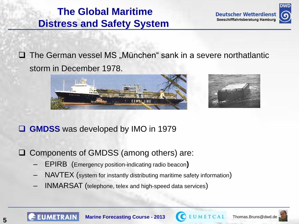
The German vessel MS „München“ sank in a severe northatlantic
storm in December 1978.
GMDSS was developed by IMO in 1979
Components of GMDSS (among others) are:
– EPIRB (Emergency position-indicating radio beacon)
– NAVTEX (system for instantly distributing maritime safety information)
– INMARSAT (telephone, telex and high-speed data services)
The Global Maritime
Distress and Safety System

Marine Forecasting Course - 2013 [email protected] 7
Casualities in 2008
Number of Casualties by Region and Type - 2008
Cause Africa Asia
Austral-
asia Europe
Indian
Sub-
Continent
Middle
East
North
America Other
South
America Total
Collision (vessels) 6 203 3 203 15 14 58 9 9 520
Contact (eg. Harbour wall) 2 26 4 171 2 3 77 7 3 295
Fire/explosion 7 34 6 105 5 5 46 18 6 232
Foundered (sunk, submerged) 7 44 4 44 3 3 31 8 3 147
Hull damage 3 5 2 28 2 4 39 3 6 92
Labour dispute 1 3 1 5
Machinery damage/failure 29 70 16 425 7 25 173 41 15 801
Miscellaneous 10 20 11 134 6 4 68 21 8 282
Missing/overdue 1 1
Piracy 33 8 1 42 1 85
War loss/damage 1 1
Wrecked/stranded 10 47 13 262 4 19 113 19 14 501
Total 108 458 59 1376 45 119 606 126 65 2962
Marine Forecasting Course - 2013 [email protected] 8
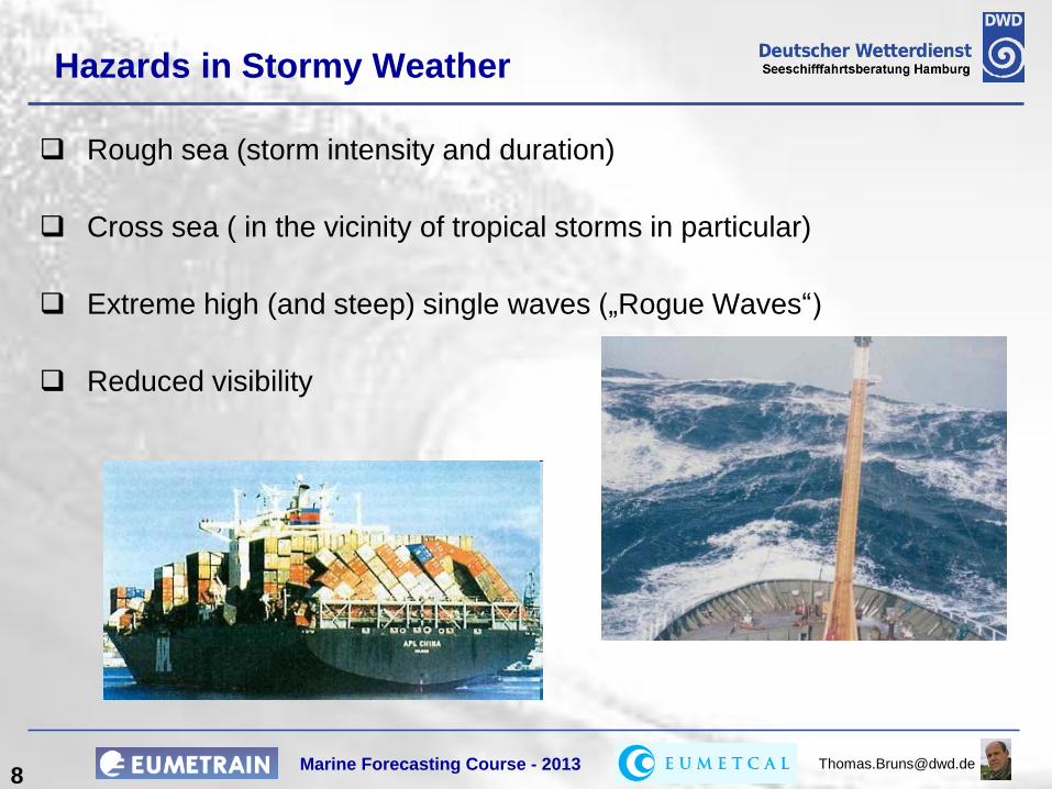
Hazards in Stormy Weather
Rough sea (storm intensity and duration)
Cross sea ( in the vicinity of tropical storms in particular)
Extreme high (and steep) single waves („Rogue Waves“)
Reduced visibility

Marine Forecasting Course - 2013 [email protected] 9
Ocean Waves
The Wave Spectrum
Significant wave height (Hs) =
– the mean wave height (trough to crest) of the highest third of the waves
(H1/3 definition for „trained observers“)
– four times the square root of the zeroth-order moment of the wave
spectrum (Hmo)
Rogue (freak) wave = higher than twice Hs
Frequency distribution of wave height
Nu
mb
er
of
wav
es w
ith
in a
tim
in
terv
al
Wave height

Marine Forecasting Course - 2013 [email protected] 10
Other Hazards
Icebergs (growlers)
Sea Ice
Freezing spray (superstructure icing)
High swell waves (resonance effects)
Fog
Cold upwelling (may affect cargo)
Currents (may affect speed and heading, interaction with waves)
Piracy

Marine Forecasting Course - 2013 [email protected] 11
e
Hazards in the North Pacific Winter
Greatest potential for tropical development
Main area of cyclogenesis
Secondary area of cyclogenesis
Primary storm track
Kuroshio current
Northeast monsoon
Tehuantepecers
ice
Superstructure icing
Superstructure icing
Heavy NW-ly swells
Courtesy of Weather News International

Marine Forecasting Course - 2013 [email protected] 12
Hazards in the North Atlantic Winter
Main area of cyclogenesis
Secondary area of cyclogenesis
Primary storm track
Gulf Stream current
Mistrals
ICE
Icebergs Super-
structure icing
Heavy NW-ly swells
Courtesy of Weather News International

Marine Forecasting Course - 2013 [email protected] 13 13
Wave Height Percentiles
95% - Quantiles of Significant Wave Height

Marine Forecasting Course - 2013 [email protected] 14
Environment
Short Term
Weather Variability
Climatology
Planning a Route
Mission Take cargo from A to B
Strategy Choose / modify the route
Operation Choose Speed and Course
Ship Performance
Requirements Navigability
Safety
Rentability
Habitability (Comfort)

Marine Forecasting Course - 2013 [email protected] 15
Climate Navigation
Sailing Ships
Steam Ships
Tropical and extra-tropical storm tracks
Monsoon regimes
Areas of high swell
Sea ice cover
Prevailing ocean currents
Climate routes reflect the
seasonal variation of
From : Scharnow et.al. Maritime Wetterkunde

Marine Forecasting Course - 2013 [email protected] 16
Weather Navigation
First follow the climate route and deviate if the weather becomes better or worse
First follow the shortest track and deviate if the weather becomes worse
Two basic strategies :

Marine Forecasting Course - 2013 [email protected] 17
The Climate Route
From Florida to the English Channel
via Abaco and Azores
4082 nm
Rhumblines

Marine Forecasting Course - 2013 [email protected] 18
Shortest Track : The Great Circle
From Florida to the English Channel
via Florida Strait
3778 nm
Great Circle

Marine Forecasting Course - 2013 [email protected] 19
Weather Navigation
4072nm
Start on great circle,
fall back to climate route

Marine Forecasting Course - 2013 [email protected] 20
Regional Features
Making use of Gulf stream
in the Florida Strait
Traffic Separation
in the Singapore Strait

Marine Forecasting Course - 2013 [email protected] 21
Tactical Weather Routing (Meteorological Navigation)

Marine Forecasting Course - 2013 [email protected]
The Marine Meteorological Office
in Hamburg
22 22
Ocean Wave Forecast
Ship Routing
Consultancy for the Offshore Industry
Advisory onboard German Research Vessels
Antarctic Flight Weather Guidance
Analyses of Maritime Accidents
Regatta Guidance
Online Weather Information Systems
Research Projects
Marine Forecasting Course - 2013 [email protected] 23
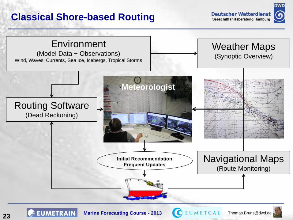
Classical Shore-based Routing
Environment (Model Data + Observations)
Wind, Waves, Currents, Sea Ice, Icebergs, Tropical Storms
Routing Software (Dead Reckoning)
Weather Maps (Synoptic Overview)
Navigational Maps (Route Monitoring)
Meteorologist
Initial Recommendation
Frequent Updates

Marine Forecasting Course - 2013 [email protected] 24
Sign. Wave
Height
Swell Height Ship speed + course
From Emden to Brunsbüttel
Routing for Coastal Shipping

Marine Forecasting Course - 2013 [email protected] 25
Contents of a Route recommendation Text
Weather situation and development
Waypoints of the recommended route
Alternate route(s)
Forecast weather enroute
Additional notes on hydrographical hazards
Grafics
On request : maps of surface pressure, wind, waves Media
Fax
SMS
Phone
Telex
Monitoring and updated recommendations
Ships will be monitored enroute by their consultant with regard to
Unexpected weather changes
Changing weather forecasts
Deviations from the recommended route Recommendations will be updated if necessary, however, at least every 3 days. Ships are requested to send their position and observed weather every day.
From: German Meteorological Service (DWD), Marine Met Office
Weather Ship Routing WV 13, phone/fax ++69 69 8062 6187/6184
issued: 29.09.04 11 UTC
To
1. MV Example
0582 999777888
2. Shipping Company
Ref.: Routing/track weather forecast
Synoptic situation and development: Low 29./00UTC 998 central Japan moving east but slowly, weakening, 01./00UTc 1004
37N145E, then filling. Large high 29./00UTC 1034 45N160E moving east, 01./00UTC 1035 45n180E, moving south furtheron, 03./00UTC 1032 40N180E.
Low 3./00UTC 1002 45N155W moving south. No tropical storms reported.
We therefore recommend great circle to waypoint 4630N164E,
then rhumbline to Cape Flattery. Estimated average speed 24.6kt
Forecast : 29.09.: East to southeast abt. 4, sea near 2 m
30.09.: veering south increasing up to 7,
sea 2 to 3 m, incoming southerly swell 3 to 4 m
01.10.: South to southwest 7, sea 3 to 4 m
02.10.: southwest decreasing 6, sea 2 to 3 m
03.10.: veering northwest 5, decreasing 3 , sea still 2 to 3 m
04.10.: becoming southeast 4 to 5, sea 2 m
NOTE: In case of significant change of weather, you will
receive further recommendation enroute. Please send your
daily noon-observation to dwd in standard weather observation code
(WMO-code) or at least in the following form under code "Routing" :
A: Date and Time (local time and UTC)
B: Position (e.g: Pos. 55.03n 11.30w)
C: Wind in BFT (e.g: Wind NW 5)
D: Sea and Swell in m (e.g: Sea 3m, Swell SW 4m)
E: Significant weather (e.g: sign.Wx Thunderstorms).
Our office is on duty around the clock:
telex: 211 291 hadwd Fax: +49-69-8062-6184 E-mail: routing(AT)dwd.de
good voyage
Erdmann/DWD Marine Meteorological Service
Text Messages

Marine Forecasting Course - 2013 [email protected] 26
Other Providers of Shore-based Routing
http://www.metworksltd.com/services/fwr.htm
http://www.oceansltd.com/route.html
http://www.wriwx.com/cargo/home.php
http://oceanweatherservices.com/
These are just a few examples!
Google for more!

Marine Forecasting Course - 2013 [email protected] 27
Route Optimization
Minimum cost (all ships)
Minimum fuel (freight liner).
Minimum time (tramp shipping)
Best weather (cruise ships)
Safety and comfort of personnel and passengers
Need to take a chance for maintenance work at sea
Marine Forecasting Course - 2013 [email protected] 28
The Costs of a Shipping Mission
Fuel consumption, variable fuel prices
Employees (salaries, flights, hotels etc)
Insurance rates
Charges for pilots, water gates etc.
Demurrage (in case of early arrival)
Unpredictable events (damages, traffic jam, strike at destination etc)
The true costs are quite difficult to estimate!

Marine Forecasting Course - 2013 [email protected] 29
Minimize the
cost function
)n..n ,h..h ,X..Xf( = t
)t,tB( + t)dtn,h,A(X, = J
z0z0z0z
sz
t
t
z
0
A cost per time
X ship position
h heading
n propeller rotation
B late/early arrival penalty
Arrival time
Route Optimization
Ship must not hit land, sea ice, icebergs, shoals
Traffic separation zones must be considered
The propeller rotation must not exceed certain upper and lower limits
Ship motions must not exceed acceptable limits
Side Conditions:

Marine Forecasting Course - 2013 [email protected] 30
The most simple Solution
Minimize the
cost function
A = 1 B = 0
) t , t B( + t)dt n, h, A(X, = J s z
t
t
z
0
Time Optimization :
Speed vs. Wave height / direction

Marine Forecasting Course - 2013 [email protected] 31
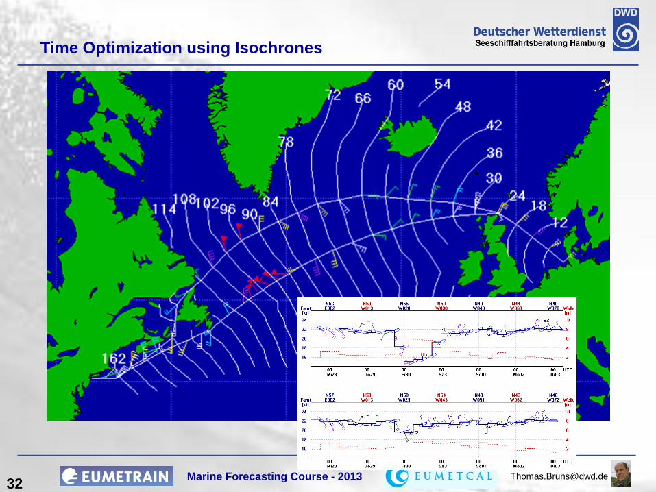
Isochrones are lines of equal arrival time
Time Optimization using
the Isochrone Method
Marine Forecasting Course - 2013 [email protected] 34
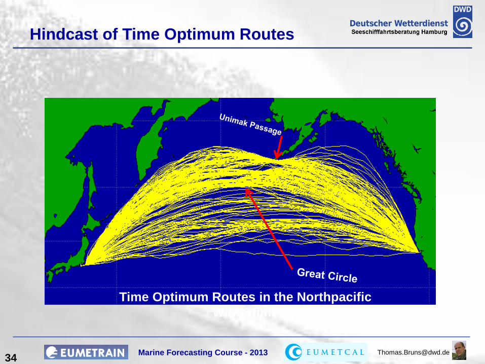
Hindcast of Time Optimum Routes
Time Optimum Routes in the Northpacific
Wintertime

Marine Forecasting Course - 2013 [email protected] 35
Winter Summer
Westbound Route Climatology
for a Gas Tanker
Westbound
Eastbound
Time loss (relating to calm conditions)
Marine Forecasting Course - 2013 [email protected] 36
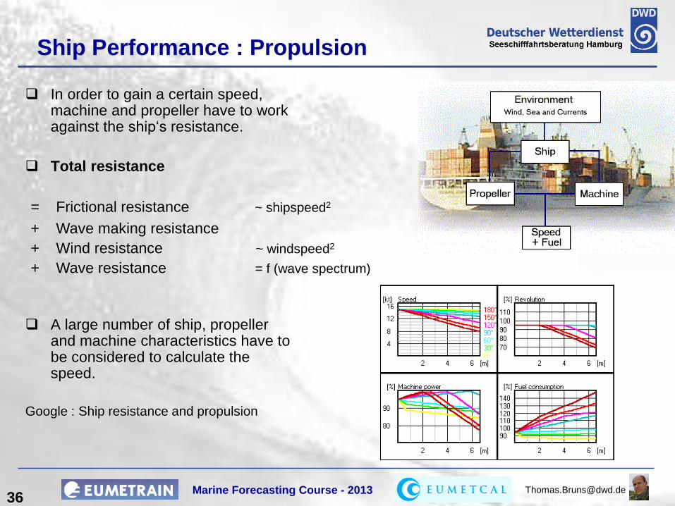
Ship Performance : Propulsion
In order to gain a certain speed, machine and propeller have to work against the ship‘s resistance.
Total resistance
A large number of ship, propeller and machine characteristics have to be considered to calculate the speed.
Google : Ship resistance and propulsion
= Frictional resistance ~ shipspeed2
+ Wave making resistance
+ Wind resistance ~ windspeed2
+ Wave resistance = f (wave spectrum)

Marine Forecasting Course - 2013 [email protected] 37
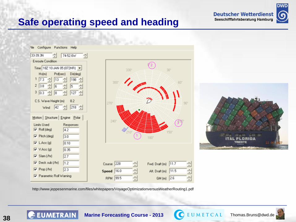
Slamming
Parametric rolling
(may occur in following or
heading seas)
Supercritical accelerations / bending stresses
Green water on deck
Propeller emerging
Psychological constraints
Hazardous Events
Voluntary speed reduction
Marine Forecasting Course - 2013 [email protected] 38
http://www.jeppesenmarine.com/files/whitepapers/VoyageOptimizationversusWeatherRouting1.pdf
Safe operating speed and heading

Marine Forecasting Course - 2013 [email protected] 39
Linear Programming (Kantorovich, 1939)
Dynamic Programming (Bellman, 1957)
Branch & Bound (Land & Doig, 1960)
Sophisticated Optimization Techniques
Optimization using
Dynamic Programming
http://www.jeppesenmarine.com/files/whitepapers/VoyageOptimizationversusWeatherRouting1.pdf

Marine Forecasting Course - 2013 [email protected] 40
Onboard Routing Software
http://www.awtworldwide.com/products/
http://ww1.jeppesen.com/marine/commercial/vvos/commercial-marine-product.jsp
http://www.ocean-systems.com/VOSS.htm
These are just a few examples!
Google for more!

Marine Forecasting Course - 2013 [email protected]
Ensembles of Optimum Routes
Considering the uncertainties of the medium range weather forecast
(>3 days) by using an Ensemble Prediction System.
41
Courtesy of ECMWF
1 Deterministic run
1 Control run
50 ensemble members
H
H
H
L
L
L
L
Cntr T639 Cluster 1
H
H
H
H
H
L
L
L
OPR T1279 Cluster 1
MSLP (contour every 5hPa) and Temperature at 850hPa (only-6 and16 isolines are plotted)
Monday 11 October 2010 12UTC ECMWF Forecast t+120 VT: Saturday 16 October 2010 12UTC Surface: Mean sea level pressure
ECMWF ENSEMBLE FORECASTS
H
H
H
H
L
L
L
1000
1005
Member 1 Cluster 1
H
H
H
H
L
L
L
Member 2 Cluster 1
H
H
L
Member 3 Cluster 1
H
H
HH
H
L
L
L
Member 4 Cluster 1
HH
H
H
L
L
L
Member 5 Cluster 1
H
H
H
L
Member 6 Cluster 1
HH
H H
L
L
1015
-6
Member 7 Cluster 1
H
H
H
H
H
H
L100
0
1005
Member 8 Cluster 1
H
H
H
H
H
LL
L
Member 9 Cluster 1
H
H
H
H
L
L
L
L
Member 10 Cluster 1
H
H
H
H
LL
L
1005
1010
1015
Member 11 Cluster 1
H H
H
H
H
HL
L
L
Member 12 Cluster 1
H
H
H
L
L
L
Member 13 Cluster 1
H
H
H
L
1005
Member 14 Cluster 1
H
H
H
H
L
L
L
10051010
Member 15 Cluster 1
H
H
H
H
L
L
L
1015
Member 16 Cluster 1
H
H
H
H
H
LL
L
L
L
Member 17 Cluster 1
H
H
H
H
H
L
L
L
L
Member 18 Cluster 1
H
H
H
H
LL
L
Member 19 Cluster 1
H
H
HH
H
L
L
1010
Member 20 Cluster 1
H
H
H
H
H
LL
L
Member 21 Cluster 1
H
H
H
HH
H
L
L
Member 22 Cluster 1
H
H
H
L
L
1010
Member 23 Cluster 1
H
H
H
H
H
L
L
L
1010
Member 24 Cluster 1
H
H
H
H
L
L
L
1015
Member 25 Cluster 1
H
H
HH
L
L
L
L
1015
Member 26 Cluster 1
H H
H H
L
L
Member 27 Cluster 1
H
H H
H
L
L
L
1010
Member 28 Cluster 1
H
H
H
H
L
Member 29 Cluster 1
H
H
H
LL
L
L
Member 30 Cluster 1
H
H
H
H
L
L
1005
Member 31 Cluster 1
H
H H
H
L
L
L
L
Member 32 Cluster 1
H
H
H
HL
L
L
Member 33 Cluster 1
H
H
H
H
H
H
L
L
L
L
10001005
Member 34 Cluster 1
H
H
H
H
L
L
L
L
Member 35 Cluster 1
H
H
H
H
L
L
1005
1010
Member 36 Cluster 1
H
H
H
H
L
L
L
L
Member 37 Cluster 1
H
H
H
H
L
Member 38 Cluster 1
H
H
L
L
L
Member 39 Cluster 1
H
H
H
H
L
L
L
Member 40 Cluster 1
H
H
H
H
H
H
L
L
L
L
Member 41 Cluster 1
H
H
H
H
L
L
L
-6
Member 42 Cluster 1
H
H
H
L
L
L
-6
Member 43 Cluster 1
HH
H
H
H
H
L
L
1010
Member 44 Cluster 1
H
H
H
H
L
L
L
1005
Member 45 Cluster 1
H
H
H
H H
L
L
1010
Member 46 Cluster 1
H
H
H
H
L
L
L
1010
Member 47 Cluster 1
H
H
H
H
L
L
L L
L
Member 48 Cluster 1
H
H
H
L
L
1000
1005
1010
Member 49 Cluster 1
HH
HH
H
H
L
L
Member 50 Cluster 1
ECMWF - EPS

Marine Forecasting Course - 2013 [email protected]
Conclusions
Onboard Route Optimization
– considering specific ship performance
– large data sets increase communication costs
– optimum route may strongly depend on selection of options
Shore-Based Routing
– information on ship properties often insufficent (chartered ships)
– access to a variety of forecast models
– MetOcean experts give short and clear advice
42