Introduction to Prescribed Fire in Southern · PDF fileare listed under Suggested Reading at...
88
United States Department of Agriculture Forest Service Research & Development Southern Research Station Science Update SRS-054 AUGUST 2012 Slightly revised 2015 Reprinted 2016 Slightly revised 2018 Introduction to Prescribed Fire in Southern Ecosystems
Transcript of Introduction to Prescribed Fire in Southern · PDF fileare listed under Suggested Reading at...

United States Department of Agriculture
Forest ServiceResearch & DevelopmentSouthern Research StationScience Update SRS-054
AUGUST 2012Slightly revised 2015Reprinted 2016Slightly revised 2018
Introduction to Prescribed Fire in
Southern Ecosystems

Prescribed Burning is Fire …l Applied in a skillful mannerl Under exacting weather conditionsl In a definite placel To achieve specific results
The objective of this Introduction to Prescribed Burning is to help resource managers plan and execute prescribed burns in Southern forests and grasslands by:
l Explaining the reasons for prescribed burningl Emphasizing the environmental effectsl Explaining the importance of weather in prescribed burningl Describing the various techniques of prescribed burningl Giving general information pertaining to prescribed burning
August 2012Slightly revised February 2015
Reprinted March 2016 Slightly revised February 2018
Southern Research Station200 W.T. Weaver Blvd. Asheville, NC 28804
www.srs.fs.usda.gov

Introduction to Prescribed Fire in
Southern Ecosystems
Revised in 2012 by Thomas A. Waldrop and Scott L. Goodrick, Southern Research Station with portions contributed by Craig A. Harper, University of Tennessee, and Gene Towne, Konza Prairie Biological Station, Kansas State University.
This guide was originally written in 1966 by Merlin J. Dixon, Southern Region, USDA Forest Service. Revisions were completed in 1973 and 1979 by lead author Hugh E. Mobley, Southern Region, USDA Forest Service. The guide was rewritten in 1988 by Dale D. Wade and James D. Lunsford, Fire Management, Southern Region, USDA Forest Service.
Substantial information found in this guide came from the Rainbow Series of Wildland Fire in Ecosystems, sponsored by the Interagency Joint Fire Science Program. These publications are listed under Suggested Reading at the end of the guide.
Photographs were provided by the Auburn University Archive, Auburn University; David Guynn and Aaron Stottlemyer of Clemson University; Ron Halstead, Halstead Forestry & Realty, Inc.; Dale Wade of Rx Fire Doctor; Mike Bozzo of the SC Forestry Commission, and numerous employees of the USDA Forest Service.
Appreciation is expressed to various State and Federal Agencies, private industries, and other organizations for their helpful reviews, suggestions, and comments.
Sponsored for publication by Fire Management, Southern Region, USDA Forest Service in cooperation with U.S. Forest Service Southern Research Station.
This guide provides basic information needed to help you become technically proficient in the proper planning and use of prescribed fire. A glossary toward the end of this manual will help with unfamiliar terms. To learn more about the subject of prescribed fire, a list of suggested readings follows the glossary. Nearby State and Federal resource management agencies are also excellent sources of information. Many of the agencies provide periodic training in fire behavior and prescribed fire.

ContentsIntroduction 1 History and Ecology of Fire 1 Present Use 2 Impact of Prescribed Burning 3
Reasons for Prescribed Fire in Forest and Grassland Management 5 Reduce Hazardous Fuels 5 Dispose of Logging Debris 6 Prepare Sites for Seeding or Planting 6 Improve Wildlife Habitat 6 Manage Competing Vegetation 7 Control Insects and Disease 8 Improve Forage for Grazing 8 Enhance Appearance and Access 9 Perpetuate Species and Communities that Require Fire 9
Environmental Effects 11 Vegetation 11 Soil 12 Water Quality 13 Air 13 Human Health and Welfare 14 Wildlife 15 Aesthetics 17
Weather and Fuel Considerations 19 Introduction 19 Important Weather Elements 19 Collecting and Using Weather Information on the Burn 33
Firing Techniques 35 General 35 Backing Fire 35 Strip-Heading Fire 36 Flanking Fire 37 Point Source Fires 38 Prescribed Burning on Slopes 39 Aerial Ignition 40 Center and Circular (Ring) Firing 41 Pile and Windrow Burning 41

Smoke Management 43 Introduction 43 Smoke Management Planning 43 Daytime Smoke Evaluation 44 Nighttime Smoke Evaluation 50 Other Points to Consider 52 Executing a Smoke Management Plan 53
Planning the Prescribed Burn 55 The Written Plan 55 Simple Understory Prescribed Burning Unit Plan 58 Understory Prescribed Burning Unit Plan 59 Postharvest Prescribed Burning Unit Plan 60
Preparing for the Prescribed Burn 61 Establishing Control Lines 61 After Control Lines are Established 61 Burn Unit Map 61
Executing the Burn 63 Checklist 64
Evaluating the Burn 65 General Points to be Considered 65 Points in First Evaluation 65 Points for Second Evaluation 65 Indications and Guidelines 65
Coordination of Burning 67
General Rules 69
Red Flag Situations 70
Glossary 71
Suggested Reading 76

This publication is not intended to be a substitute for experience and
training. Predicting fire behavior and smoke movement is difficult.
The consequences of a mistake can be dangerous and costly.

Introduction
HISTORY AND ECOLOGY OF FIRE
The history of fire in the forests and grasslands of the South is as varied as the different ecosystems that span this large region. At times, fires burned as often as once a year or more in Coastal Plain pine systems or as infrequently as every 50 years or more on north-facing or cove sites in the mountains Lightning served as a major fire source in most ecosystems for millennia before Native Americans arrived some 10,000 to 12,000 years ago At that time, most plants had developed adaptations to either survive a fire or to regenerate after one. Native Americans were the first people of North America to use what we now call “prescribed burning ” Many preferred open grassland or savannah resulting from frequent burning—environments that provided access to grazers and browsers and to the wild grains, berries, and legumes that appeared after fire. European settlers, whose livelihood often depended on hunting and herding, quickly learned the advantages of firing the southern woods to control thick understory growth and provide abundant forage and browse By the late 19th century, the logging industry had become established throughout the South Excessive logging, followed by wildfires fueled by logging debris,
left millions of acres of forest land with no trees The need to control fire was evident to allow forests to regenerate; even prescribed fire was banned on lands managed by some agencies. Although fire was never completely removed from the landscape, its use was diminished for several decades until early reports suggested the advantages of prescribed fire for bobwhite quail habitat and for managing longleaf pine By the 1950s and 1960s, active programs were established for prescribed burning in Coastal Plain and lower Piedmont pine and grassland habitats
Prescribed burning in the mountains did not begin until the 1980s but this practice is gaining acceptance for some management objectives
Forests and grasslands of the South are well adapted to fire with species that have survival or regeneration strategies that not only tolerate fire but also may require it. Adaptations such as thick bark, light or winged seeds, or buried buds or meristems are common Communities that have been burned frequently, such as Coastal Plain longleaf pine, often have few trees in the overstory with a highly diverse understory of fire-adapted plants. Communities
Prescribed burning can be used in many ecosystems throughout the southeastern United States to create or maintain desired conditions.

2
burned infrequently, such as Piedmont or Appalachian hardwoods, may have a diverse collection of overstory trees which can regenerate after an intense fire by basal sprouting. Although much experience is needed, fire can be used to meet landowner objectives if the fire prescription matches the life requirements and adaptations of the plants within the community
PRESENT USE
Prescribed burning is an important tool throughout Southern forests, grasslands, and croplands In 2011, over 6 4 million acres were burned by prescription for forestry purposes in the 13 Southern States Prescribed burning is a desirable and economically sound practice in many forests and grasslands; in many cases, it is the only practical choice Few, if any, other treatments have been developed that can compete with prescribed fire for its combination of economy and effectiveness Chemical and mechanical treatments can be 10 to 20 times more expensive than prescribed burning and can have environmental costs such as destruction of habitat and soil erosion Prescribed burning can also have environmental costs associated with smoke and soil exposure but these problems can be reduced with a good fire prescription and careful execution of the burn
In this guide, prescribed burning is described as fire applied in a knowledgeable manner to forest and grassland fuels on a specific land area under selected weather conditions to accomplish predetermined, well-defined management objectives.
This manual is intended to help resource managers plan and execute prescribed burns in Southern forests and grasslands Until the 1980s and 1990s, prescribed burning was most common in Coastal Plain and lower Piedmont forests Several generations of resource managers gained experience and knowledge with prescribed burning in those regions and much of our current knowledge originated there More recently, management objectives have become broader, particularly on government lands Managers and researchers have a new appreciation for using prescribed fire in grasslands, in hardwood forests, and on steep mountain slopes Burning in these areas presents new challenges and complexities This manual will serve as an introduction to prescribed burning in each of these regions and fuel types but should not be used as a substitute for experience
Use of prescribed burning, as a component of an overall strategy of forest management, can help to maintain healthy forests. Credit for top photograph: Auburn University Archive, Auburn University, Bugwood.org
Grid ignition.
Pre-burn planning and safety meeting.

3
IMPACT OF PRESCRIBED BURNING
Most forests and grasslands require multiple prescribed fires over a number of years to fully reach management objectives, but even a single fire can provide multiple benefits. One prescribed fire can reduce wildfire hazard by reducing fuels, improve habitat for some wildlife species, reduce competition, enhance appearance, and improve access
Prescribed fires are not always beneficial. When conditions are wrong, fire can severely damage the resources they are intended to benefit. In forests, fire can reduce health or kill trees, understory plants, and animals. Prescribed fires can temporarily reduce air quality, although usually to a lesser degree than wildfires, particularly in communities and urban areas located near large wildland tracts. A prescribed fire that escapes its planned boundaries immediately becomes a wildfire. Proper planning and resources are required to prevent this danger and to control it if it should occur Each prescribed fire presents a number of tradeoffs that must be recognized and carefully weighed to reach a decision regarding if and when to burn Proper planning and execution are necessary to minimize any detrimental effects Potential off-site impacts such as air quality and downstream water quality should be carefully considered, as should on-site impacts to soil and aesthetics Opinions of the general public should always be respected as most are highly concerned about local and global environmental quality Resource managers should work with their neighbors through open communication and consider their concerns when defining burn objectives.
Prescribed fire is a complex tool and should only be used by those trained in its use Proper diagnosis and detailed planning are needed for every area where burning is contemplated The incomplete assessment of any factor can pose serious liability questions should fire escape or its smoke cause damage. A prescribed fire that does not achieve its intended objective(s) is a loss of both time
and money, and it may be necessary to reburn as soon as sufficient fuel accumulates. Keep in mind that some resource management objectives can be met with a single fire, some require several fires in fairly quick succession, and some can only be accomplished by burning periodically over several decades
Smoke obscuring a highway.


5
Reasons for Prescribed Fire in Forest and Grassland Management l Reduce hazardous fuels l Dispose of logging debrisl Prepare sites for seeding or plantingl Improve wildlife habitatl Manage competing vegetationl Control insects and disease l Improve forage for grazing l Enhance appearance and accessl Perpetuate species and communities that require fire
REDUCE HAZARDOUS FUELS
Without fire, forest fuels can accumulate rapidly. Heavy “roughs” can accumulate quickly in pine stands, posing a serious threat from wildfire to all forest resources. Fuels on the forest floor in hardwood stands may accumulate more slowly than in pine stands However, after a prescribed burn, these fuels can build up to or even exceed the dangerous pre-burn levels within three to four years
Prescribed fire is the most practical way to reduce dangerous accumulations of combustible fuels in Southern forests and grasslands. Wildfires that burn into areas where fuels have been reduced by prescribed burning cause less damage and are much easier to control The appropriate interval between prescribed burns for fuel reduction varies with several factors, including the rate of fuel accumulation, past wildfire occurrence, values at risk, and the risk of a wildfire. The time interval between fires can be as often as every year although a 3- or 4-year cycle is usually adequate in forests after the initial fuel-reduction burn Shorter cycles are necessary in grasslands to prevent shrub encroachment
The need to reduce hazardous fuel accumulations is increasing throughout the South. Without fuel reduction, fire hazard can be extremely high in vast contiguous stands Also, the rapidly-growing population of the South is expanding its wildland-urban interface and greatly increasing the number and value of resources that must be protected The initial hazard-reduction burn in young forest stands requires exacting conditions of wind, humidity, and temperature
Higher wind velocities and cooler temperatures minimize scorch damage in pine forests Southern pine plantations averaging 10 to 12 feet in height can be burned by experienced people under the right conditions without damage Aerial ignition can be used in young plantations for the first time when they are 15 to 20 feet tall by using close spacing of ignition spots, e g , 100 by 100 feet, and cool, damp conditions with some wind to avoid crown damage Hardwoods are susceptible to stem damage from even cool prescribed fires until they reach 6 to 8 inches in dbh (diameter at breast height— 4 5 feet above ground) After that, burning must be conducted under relatively cool, damp conditions if tree damage is a concern
Subsequent fuel reduction burns in pine and hardwood forests need not cover the entire area The objective is to break up fuel continuity Fuel reduction on 75 to 80 percent of the area is sufficient. An added advantage of “patchy” burns is that the unburned islands provide cover for wildlife These unburned patches will not have a dangerous accumulation of fuels at the time of the next burn if they resulted from a lack of fuel during the previous fire. If, however, they were too wet to burn, these islands could result in hot spots the next time if a heading fire is allowed to sweep through them under appreciably drier conditions Excessive crown scorch or stem damage could result in additional fuel accumulation through needle drop or even tree mortality
Annual wildfire acreage depends on the age of the rough.

6
DISPOSE OF LOGGING DEBRIS
After harvest, unmerchantable limbs and stems are left either scattered across the area or concentrated at logging decks or delimbing gates, depending upon the method of logging This material is an impediment to both people and planting equipment. If a wildfire occurs within the next few years, fireline construction can be severely hindered; the result being larger burn acreages and higher regeneration losses Although not all large material will be consumed by a prescribed fire, what is left will be exposed so it can be avoided by tractor-plow operators In stands that produce a large amount of cull material, the debris is often windrowed and burned This practice should, however, be avoided whenever practical because of smoke management problems and the potential for site degradation Broadcast burning is generally a much better alternative If the debris must be piled before burning, construct round “haystack” piles when the debris and underlying ground are both fairly dry This step will limit the amount of dirt in the pile Piles containing large amounts of dirt can seldom be burned efficiently. They almost always smolder for long periods, creating unacceptable smoke problems
In some cases, overstory trees are left during harvest whether as seed trees or as part of uneven-aged management system using single-tree or group selection In both situations, the logging debris can still be burned, but you must take more care to protect the remaining trees
PREPARE SITES FOR SEEDING AND PLANTING
Prescribed burning is useful when regenerating Southern pine by direct seeding, planting, or natural regeneration On open sites, fire alone can prepare an adequate seedbed and control competing vegetation until seedlings become established Even where competing vegetation cannot be adequately reduced by fire alone, it reduces the level of mechanical or herbicide treatment needed Fire improves visibility so equipment operators can more easily see stumps of harvested trees, as well as any other hazards In addition, if the area is to be bedded before planting, burning first consumes much of the debris. The result is more tightly packed beds and thus better seedling survival Where herbicides are used to kill competition, subsequent burning will provide additional vegetation control This also allows more efficient and easier movement of hand-planting crews. Prescribed fire also recycles nutrients, making them available for the next timber crop
For natural regeneration, knowledge of anticipated seed crop and date of earliest seed fall is essential If the seed crop is inadequate, burning can be postponed Complete mineral soil exposure is not necessary or desirable; a thin layer of litter should remain to protect the soil Generally, burning should be done several weeks prior to seed fall Timing varies with species and locality
Prescribed burning is also useful for regeneration of hardwood forests After harvest, coppice regeneration is generally anchored on the top of a stump As the sprouts mature, the stump rots and decay can be introduced to the bottom log of the new tree Burning after harvest will kill basal sprouts and force new sprouts to come from belowground buds, particularly from roots Sprouts originating from below ground are less susceptible to decay-causing fungi In some cases where low-cost regeneration of pines is desired, broadcast burning can be used to control hardwood growth long enough to allow pines to be planted and survive, later becoming a mixed-species forest
IMPROVE WILDLIFE HABITAT
Fire is essential to maintain/restore certain plant communities that many wildlife species require Examples include longleaf pine in the Coastal Plain, shortleaf pine in the Piedmont, Table Mountain and pitch pine in the southern Appalachians, oak savannas and woodlands in the Piedmont and mid-South, and early successional openings and native grasslands throughout the region. Suppression of fire in the South through the 20th century led to significant reduction in area covered by these communities The quality and integrity of the
Winter spot fire in heavy rough.
Damaging wildfire in heavy rough.

7
remnants of these communities has been compromised severely With this loss and deterioration, prevalence of associated wildlife species has declined precipitously over the past several decades with several species now endangered or threatened Likewise, several plants endemic to these communities also are now rare
Additionally, prescribed fire improves habitat conditions for many wildlife species in a wide variety of vegetation cover types, including some that are often not considered with prescribed fire, including upland hardwoods and emergent wetlands Fire sets back succession, consumes the litter layer and other dead plant material, and can improve nutrient availability for responding plant growth Prescribed burning stimulates seed germination of many species and provides open conditions at ground level for travel, loafing, and feeding by game bird broods, rabbits, and ground-feeding songbirds The responding groundcover provides forage, soft mast, and seed eaten by many birds, mammals, and reptiles. Prescribed burning also influences the composition and structure of cover available for wildlife Timing and frequency of burning determines litter depth, the height and density of cover, as well as plant diversity Thus, prescribed burning can be used to tailor habitat conditions for focal species
MANAGE COMPETING VEGETATION
Low-value, poor-quality, shade-tolerant hardwoods often occupy or encroach upon land best suited to growing pine Unwanted species may crowd out or suppress pine seedlings In soils with high clay content and in areas with low rainfall during parts of the growing season, competition for water, nutrients and growing space may significantly lower growth rates of the overstory Furthermore, understory trees and shrubs draped with dead needles and leaves act as ladder
fuels allowing a fire to climb into the overstory crowns. In most situations, total eradication of the understory is neither practical nor desirable However, with the judicious use of prescribed fire, the understory can be managed to limit competition with desired species while at the same time providing browse for wildlife Generally, a winter (dormant season) fire results in less root kill than a late spring or summer burn One system recommended in the Mountains, Piedmont and Coastal Plain is a dormant season burn to reduce initial fuel mass, followed by two or more annual (if enough fuel is present) or biennial summer burns
If not controlled, the hardwoods will form a midstory and capture the site once the pine is harvested If a large pine component is wanted in the next rotation, these unmerchantable hardwoods must be removed during site preparation— an expensive proposition. Generally, fire is required in combination with other treatments involving heavy equipment, chemicals, or both In many locations the preferred system is a combination summer burn and herbicide treatment However, a relatively inexpensive alternative can be employed if site quality is moderate to poor; all residual hardwoods are felled and the area broadcast burned under exacting fuel and weather conditions
In some cases, overstory pines or hardwoods are the competing vegetation that must be controlled Restoration of open woodland conditions is a goal for landowners who prefer a diversity of sun-loving understory plants Conversion of pine or hardwood forests with dense canopies requires removal of many trees by harvesting, chemicals, or, in limited cases, prescribed fire. Once the overstory is removed, frequent cool fires are required to maintain the open character of the forest and to allow desirable understory plants to become established
Many game and non-game wildlife species benefit from prescribed fire.
Hardwood topkill after a winter burn.

8
In upland hardwood stands, a predominantly woody understory and midstory often prevent adequate herbaceous groundcover to meet wildlife management objectives In the Ridge and Valley of Tennessee, thinning has been shown to reduce canopy closure to approximately 60 percent Low-intensity prescribed burning is then implemented during the early growing-season on a 2- to 3-year fire return interval to stimulate herbaceous understory growth and soft mast production, while controlling woody regeneration
Prescribed fire is generally thought of as a silvicultural tool for controlling hardwoods in pine management However, there is growing evidence that prescribed fire can be used in mature hardwood stands to control the composition of advanced regeneration, particularly to favor oak Oak seedlings and sprouts are more resistant to topkill than other hardwoods and will sprout after numerous fires. This advantage is most important on good quality sites where other species, such as yellow-poplar, will grow quickly and outgrow the oaks Prescribed burning can be conducted in these stands with little or no damage to overstory hardwoods but extreme caution must be used to maintain fires of low intensity.
In grasslands, prescribed fire in different seasons and at different frequencies is used as a tool to manipulate vegetation Late-spring burning reduces the abundance of forbs and favors warm-season perennial grasses, whereas early-spring burning increases the abundance of many forbs and favors cool-season perennial grasses and sedges Growing-season fires are occasionally used to increase species richness, with annual and perennial forbs and many cool-season graminoids the primary beneficiaries. Annual or biennial fires in any season are required to curtail encroachment of woody species, and infrequent burning (i e , every three to four years) stimulates the expansion of most shrub species once they have become established in grassland
CONTROL INSECTS AND DISEASE
Brownspot disease is a fungal infection that may seriously weaken and eventually kill longleaf pine seedlings Diseased seedlings tend to remain in the grass stage Control is recommended when more than 20 percent of the seedlings are infected or when some of the diseased seedlings are needed for satisfactory stocking Once the seedlings become infected, burning is the most practical method of disease control Any type of burning that kills the diseased needles without killing the terminal bud is satisfactory Burning the infected needles reduces the number of spores available to infect the seedlings. Generally a winter heading fire under damp conditions, as exist after passage of a strong cold front, is best Height growth of the seedlings often begins the first postfire-growing season after burning.
Reinfection usually occurs quickly if there are infected seedlings in unburned areas surrounding the burn unit If reinfection occurs, additional burns may be needed However, longleaf is most susceptible to fire immediately after it comes out of the grass stage Therefore, a reburn will likely kill some seedlings, so such a decision should be made in consultation with experienced personnel Your local State forestry office is a good place to begin.
Prescribed burning seems to reduce problems from Fomes annosus root rot This fungal disease is less frequent where periodic burns have reduced the litter Fire alters the microenvironment of the forest floor and perhaps destroys some fruiting bodies and cauterizes tree stumps Prescribed burning has not been shown to be effective at controlling disease in hardwood forests Although little research has been conducted on this topic, one of the major diseases in hardwoods, a root-borne disease caused by Phytophthora cinnamomi, was not reduced by repeated fire in the southern Appalachian Mountains. This fungus is predominant in the soil and prescribed fires generally do not heat the soil sufficiently to lower the incidence of soil-borne diseases
IMPROVE FORAGE FOR GRAZING
Prescribed burning improves grazing conditions by increasing the quality, palatability, and availability of grasses and forbs Dead material low in nutrient value is removed, while new growth high in protein, phosphorus, and calcium becomes readily available. These benefits are manifested in increased seasonal cattle weight gains Cattle congregate on recently burned areas; thus, burn location and size must be carefully selected to prevent overgrazing
Longleaf pine infected with brownspot needle blight. Photo by Ron Halstead, Halstead Forestry & Realty Inc., Bugwood.org

9
Patch-burn grazing is a system developed to reduce homogeneity in the pasture and create a mosaic grazing pattern Under this system, approximately one-third of the pasture is burned each year, but cattle have access to the entire area Because the animals preferentially graze in the burned section it is grazed intensively and the unburned areas are either grazed lightly or are ungrazed At the end of the growing season, cattle are removed from the area The following year another third of the area is burned and cattle are allowed back into the pasture This pattern continues with the entire area burned on a 3-year rotation Timing of burning should be adjusted based on vegetation composition For example, bluestems, indiangrass, switchgrass, and eastern gamagrass respond best to early spring fire, while wiregrass responds best to mid-growing-season fire. The resultant grazing pattern creates a heterogeneous landscape, with one area heavily grazed, another area lightly grazed, and a third area that received little or no grazing
Early successional wildlife respond exceptionally well to patch-burn grazing Game birds and songbirds nest in the unburned area, but raise broods and feed in the burned area where the structure is more favorable
Patch-burn grazing is applicable to areas dominated by native grasses as well as areas with considerable brushland and woodland The entire area is fenced, quarter- or third-sections burned each year, and cattle manage vegetation structure Cattle producers who have an interest in wildlife should give this system serious consideration
ENHANCE APPEARANCE AND ACCESS
Prescribed burning improves recreation and aesthetic values For example, burning maintains open stands, produces vegetative changes, and increases numbers and visibility of flowering annuals and biennials. Burning also maintains open spaces such as mountain balds and creates vistas Unburned islands increase vegetative diversity which attracts a wider variety of birds and animals A practical way to maintain many visually attractive vegetative communities and perpetuate many endangered plant species is through periodic use of prescribed fire.
Using fire to manage landscapes and enhance scenic values requires judiciously planned and executed burns, especially where there is considerable exposure to the public Burning techniques can be modified along roads and in other heavily used areas to ensure low flame heights, which in turn will reduce visible damage to trees while still opening up the stand and giving an unrestricted view
Burning underbrush prior to the sale of forest products improves the efficiency of cruising, timber marking, and harvesting Removing accumulated material before harvesting also provides greater safety for timber markers and loggers due to better visibility and less underbrush The reduced amount of fuel helps offset the greater risk of wildfire during harvesting. Moreover, the improved visibility and accessibility often increase the stumpage value of the products. Hikers also benefit from easier travel and increased visibility and hunters are more likely to get a clear shot at their quarry
PERPETUATE SPECIES AND COMMUNITIES THAT REQUIRE FIRE
Many plants have structural adaptations, specialized tissues, or reproductive features that favor them in a fire-dominated environment Such traits suggest a close association with fire over a very long period of time. Many endemics are only found the first 1 to 2 years after a fire. Changes in the “natural” fire pattern as a result of attempted fire exclusion have led to dramatic decreases in many of these fire-tolerant or fire-dependent species.
Many plants, including picturesque orchids and coneflowers, are currently listed as threatened or endangered and are benefited by fire. Fire dependent and fire tolerant plants are found throughout the South in a variety of cover types and fire regimes ranging from pine forests that burn frequently to lowland bogs and north-facing mountain coves that burn very infrequently
Table Mountain pine benefits from fire by opening serotinous cones and creating optimal seedbed habitat.

10
Prescribed burning, however, does not automatically help perpetuate plant and animal species because fires are not necessarily conducted during the same season in which the site historically burned. The interval between prescribed fires as well as fire intensity may also differ from those of the
past The individual requirements of a species must therefore be understood before a fire can be prescribed to benefit that species In some cases, such as with Table Mountain pine, fire managers are only now learning the season and intensity of fire needed for successful regeneration.
Red-cockaded woodpeckers (left) and smooth coneflower (right) require the conditions created by frequent burning to survive.

11
Environmental EffectsPrescribed burning has direct and indirect effects on the environment. Proper use of prescribed fire and evaluation of the benefits and costs of a burn require knowledge of how fire affects vegetation, wildlife, soil, water, and air. Burning techniques and timing of burns can be varied to alter fire effects
VEGETATION
Fire effects on plants can vary considerably among fires and within the same fire. The degree of injury, mortality, and recovery of plants from fire is influenced by fire behavior, fire duration, season of burning, the pattern of fuel consumption, and the amount of subsurface heating Post-fire responses can vary by plant species because they differ in their ability to survive fire and their ability to regenerate after fire.
Most plant cells are killed if they are heated to 122—131 oF (50—55 oC) for a short time or they can be killed by exposure to lower temperatures for longer periods Slow-moving cool fires can kill as many plants as faster-moving hot fires. Actively growing meristems, such as the cambium or buds of trees and basal meristems of grasses are most susceptible to heat and are easily damaged The degree to which these tissues are protected by bark, scales, or soil determines if a plant will survive fire. Pines and some hardwoods have thick bark which insulates them from heat Tall crowns protect buds and foliage from the heat of ground fires. Hardwood trees are generally more susceptible to fire injury than are pines because their bark is thinner With the exception of Eastern white pine and Virginia pine, southern pines 3 inches or more in ground diameter have bark thick enough to protect the stems from damage by most prescribed fires. However, the crowns are
Hardwood topkill.
Lethal time-temperature curve.
Most pine species are well adapted to frequent low-intensity fires.
Crown scorch can add fuels to the forest floor, reduce growth, or cause tree mortality.

12
quite vulnerable to temperatures above 135 °F Pine needles will survive exposure to 130 °F for about 5 minutes, while similar needles exposed to 145 °F for only a few seconds will die Crown scorch in pines does not always indicate that the trees will die but it usually slows growth for a year or more If the duff layer is consumed, roots are frequently damaged which can lead to moisture stress and possibly mortality if a significant portion of the feeder roots die.
Larger plants are generally better protected from fire than smaller ones because their meristems are better protected by thicker bark, taller crowns, and thicker duff Prescribed fires often topkill (mortality of all aboveground portions of the plant) hardwoods less than 6 inches dbh and pines less than 3 inches dbh Prescribed burning has traditionally been avoided in hardwood stands because fire scars are prevalent and can reduce the value of crop trees However, in recent years prescribed burning has been used in hardwood stands for site preparation, to favor establishment of oaks, enhance conditions for wildlife, and to restore stand structure to historical conditions
Most southern pines, larger than sapling size, are able to tolerate a high degree of crown scorch, especially during the dormant season, with minimal effects on survival Most pine species produce several flushes of needle growth during a growing season giving them the ability to leaf out soon after defoliation Pines are most susceptible to scorch in spring when leaders are succulent but can survive after almost complete scorching at any other time although some mortality may occur
After prescribed fires, plants regenerate by sprouting, seeding, or both Most hardwood trees and perennial forbs produce sprouts from buds located at or beneath ground level after their aboveground portions are killed by fire. Grasses vary by species but most sprout from basal meristems Few pine species sprout. Wildfires that kill overstory pines and hardwoods commonly shift species composition from pine-dominated forests to a newly regenerated hardwood
coppice forest This can also be a concern when prescribed burning is used to reduce fuels in blow-down or beetle-killed areas Regeneration by seed is also impacted by prescribed burning. Although many seeds on the forest floor are consumed by prescribed fire, others remain viable for years and are stimulated by fire. Natural regeneration of pines can be successful if prescribed burning is timed prior to a heavy seed crop Some pines have serotinous cones which are stimulated to open by the heat of a fire. This can be successful with a properly executed prescribed fire. Other tree species have light or winged seeds which are carried by wind into burned areas Germination and survival of seedlings are generally improved by prescribed burning due to a thinner duff layer, exposed soil, and increased available sunlight reaching the forest floor.
Fire affects not only individual plant species but also entire communities Community structure can be managed by prescribed burning. For example, a single prescribed fire can be used to reduce the shrub layer and, if burning is frequent, a grass and forb layer will replace the shrubs The absence of fire over time will favor more shade-tolerant and less fire-tolerant species.
Many benefits from prescribed fire, such as increased forage for grazing and improved conditions for wildlife, depend on changes in the vegetation. However, fire that is used unwisely may adversely alter plant species composition and structure
SOIL
The interaction of many factors determines the impact of fire on soil but most evidence indicates that low-intensity prescribed fires have few, if any, adverse effects. Prescribed fires affect soil by both heat transfer and changes in soil physical properties The most important soil physical characteristic affected by fire is soil structure because organic matter can be lost at relatively low temperatures Loss of soil structure can increase bulk density and reduce
Burning under dry conditions can cause erosion, especially in hilly terrain.

13
porosity, thereby reducing soil productivity and making the soil more vulnerable to post-fire runoff and erosion. Prescribed burning in the South normally causes little or no detectable change in amount of organic matter in surface soils In fact, slight increases have been reported on some burned areas However, burning piled or windrowed debris, or burning when fuel and/or soil moisture conditions are extremely low, may elevate temperatures long enough to ignite organic matter in the soil as well as alter the structure of soil clays
Changes in soil fertility and nutrient content depend largely on organic matter because soil organic matter plays a key role in nutrient cycling, cation exchange, and water retention When organic matter is combusted, the stored nutrients are either volatilized or quickly used by microbial organisms and vegetation Those available nutrients not immobilized are easily lost by leaching or surface runoff and erosion Nitrogen is the most important nutrient affected by fire, and it is easily volatilized and lost from the site at relatively low temperatures With prescribed burning, duff layers should not be completely consumed, so that changes in soil pore space and infiltration rate are very slight If mineral soil is repeatedly exposed, rain impact may clog fine pores with soil and carbon particles, decreasing infiltration rates and aeration of the soil. Soil microbial populations, important for decomposition and nutrient cycling, are resilient to fire, especially low-intensity prescribed fires. Recolonization to preburn levels is common when prescriptions that protect forest floor, humus layers, and soil humus are followed
A major concern of land managers is how fires affect surface runoff and soil erosion On most Lower and Middle Coastal Plain sites, there is little danger of erosion In the steeper topography of the Upper Coastal Plain, Piedmont, and Mountains, some soil movement is possible, but not typical If the burn is under a timber stand and some duff remains, soil movement will be minor, much less than after site preparation with heavy machinery Duff should be wet or damp at the time of burning to ensure that an organic layer will remain after a prescribed burn Moisture not only protects the duff layer adjacent to the soil, but also prevents the fire from consuming soil humus.
WATER QUALITY
With prescribed burning, the principal concerns for water are runoff and increases in sediment, nitrate and heavy metal content When surface runoff increases after burning, it may carry suspended soil particles, dissolved inorganic nutrients, and other materials into adjacent streams and lakes, thus reducing water quality. Prescribed fires are usually not severe so these effects seldom occur after Coastal Plain burns On steep terrain, however, if post-fire storms deliver large amounts of precipitation or short-duration, high-intensity rainfalls, accelerated erosion and runoff can occur even after a carefully planned prescribed fire.
Rainwater leaches minerals out of the ash and into the soil In sandy soils, leaching may also move minerals through the soil layer into the ground water Generally, a properly planned prescribed burn will not adversely affect either the quality or quantity of ground or surface water
AIR
The Federal Wildland Fire Policy (U S Department of the Interior and U S Department of Agriculture 1995) and the Clean Air Act as Amended 1990 (PL 101-549) resulted in the need to significantly raise the level of knowledge Backing fires produce less smoke than heading fires.
Protect streamside zones.

14
about the effect of fire on air quality in order to meet regulatory and management requirements For example, new information is needed to assess, monitor, predict, and manage:
l Emissions and air quality impacts from wildfiresl Acute health effects of human exposure to smokel Natural and anthropogenic sources of visibility reductionl Cumulative air quality impacts from expanded fuel
management programsl Tradeoffs between air quality impacts from wildland fire
and prescribed fire
Prescribed fires may contribute to changes in air quality. Air quality of a regional scale is affected only when many acres are burned on the same day Local problems are more frequent and occasionally acute because of the large quantities of smoke that can be produced in a given area during a short period of time
Smoke consists of small particles (particulate) of ash, partly consumed fuel, and liquid droplets Other combustion products include invisible gases such as carbon monoxide, carbon dioxide, hydrocarbons, and small quantities of nitrogen oxides Oxides of nitrogen are usually produced at temperatures only reached in piled or windrowed slash or in very intense wildfires. In general, prescribed fires produce inconsequential amounts of these gases Except for organic soils (which are not generally consumed during prescribed burns), forest fuels contain very little sulfur, so oxides of sulfur are rarely a problem
Particulates, however, are of special concern to the prescribed burner because they reduce visibility and increase health risks The amount of particulate put into the air depends on amount and type of fuel consumed, fuel moisture content, and rate of fire spread as determined by timing and type of firing technique used. Rate of smoke dispersal depends mainly on atmospheric stability and wind speed
Smoke adversely impacts air quality, particularly for two of the EPA’s pollutants covered by the National Ambient Air Quality Standards (NAAQS), PM2 5 (particulate matter smaller than 2.5 microns) and ozone. Wildland fires release significant amounts of PM2.5 and while fires do not release ozone, they do release various nitrogen oxides and volatile organic components that play a role in ozone formation The EPA’s AirNow website (http://www airnow gov) provides daily estimates of the air quality as well as forecasts of expected changes in air quality
Smoke can be managed by burning on days when it will blow away from smoke-sensitive areas Precautions must be taken when burning near populated areas, highways, hospitals, airports, and other smoke-sensitive areas Weather and smoke management forecasts are available as a guide for wind speed and direction Any smoke impact downwind must be mitigated before lighting the fire. All burning should be done in accordance with applicable smoke management guidelines and regulations During a regional alert when high pollution potential exists, all prescribed burning should be postponed
Nighttime burning should be done with additional care because a temperature inversion may trap smoke near the ground This smoke can create a serious visibility hazard, especially in periods of high humidity (which occurs on most nights) In particular, smoke mixing with existing fog will drastically reduce visibility In mountainous areas, cool air drainage at night will carry smoke down slopes, causing visibility problems in lowlands and valleys On the Coastal Plain, nighttime air drainage often follows waterways Conditions can be especially hazardous near bridge crossings because of the higher humidity there Of course, the earlier in the day a fire is completed, the less likely it is to cause nighttime smoke problems
HUMAN HEALTH AND WELFARE
Occasional brief exposure of the general public to low concentrations of drift smoke is more a temporary inconvenience than a health problem High smoke concentrations can, however, be a very serious matter Health of all neighbors is of great concern but several subgroups within the population are more sensitive than others Children are more likely to have decreased pulmonary function, while increased mortality has been reported in the elderly and in individuals with cardiopulmonary disease Asthmatics are especially susceptible to smoke exposure Great care must be taken with any management fire, particularly near homes of people with respiratory illnesses or near health-care facilities
Prescribed burning can be used in a manner to avoid smoke sensitive areas. Smoke from wildfires cannot be controlled.

15
Smoke can have negative short-and long-term health effects Fire management personnel who are exposed to high smoke concentrations often suffer eye and respiratory system irritation Under some circumstances, continued exposure to high concentrations of carbon monoxide at the combustion zone can result in impaired alertness and judgment Over 90 percent of the particulate emissions from prescribed fire are small enough to enter the human respiratory system These particulates can contain hundreds of chemical compounds, some of which are toxic The repeated, lengthy exposure to relatively low smoke concentrations over many years can contribute to respiratory problems and cancer But, the risk of developing cancer from exposure to prescribed fire has been estimated to be less than one in a million
Although the use of herbicides in forest management has increased, all chemicals are now tested before being approved for use, and we are more careful than ever to minimize their potential danger Many of them break down rapidly after being applied Moreover, both theoretical calculations and field studies suggest prescribed fires are hot enough to destroy any chemical residues Minute quantities that may end up in smoke are well within currently-accepted air quality standards Threshold limit values (TLVs) are often used to measure the safety of herbicide residues in smoke Expected exposure rates of workers to various brown-and-burn combinations have been compared with TLVs They showed virtually no potential for harm to workers or the general public
There is at least one group of compounds carried in smoke that can have an immediate acute impact on individuals Smoke can cause skin rashes when noxious plants such as poison ivy burn These rashes can be much more widespread on the body than those caused by direct contact with the plants Wear respirators or avoid inhaling any smoke when burning areas where poison ivy grows
WILDLIFE
The major effects of prescribed burning on wildlife are indirect However, a change in the structure and composition of vegetation impacts availability of food and cover, which directly influences the health, abundance, and diversity of wildlife Direct mortality of wildlife from prescribed burning is rare
Prescribed burns can be scheduled during periods that are not critical to reproduction and survival of wildlife For example, burning can be conducted outside the primary nesting season of focal species, and areas may be burned on a rotation and scale such that adequate cover is always available in the appropriate proximity for nesting, rearing young, feeding, escaping predators, and winter survival
Season and frequency of burning and the size of the area burned is crucial to the successful use of fire to improve wildlife habitat A change in vegetation structure and composition can be good for some species and not so good for others Prescriptions must recognize the biological requirements of focal wildlife species
Grassland birds, scrubland birds, forest birds —Prescribed fire rejuvenates and maintains grassland habitat for eastern meadowlark, Henslow’s sparrow, grasshopper sparrow, dickcissel, field sparrow, and others. However, because a litter layer is important for some ground-nesting birds, a 2- to 3-year fire return interval at the end of the dormant season may be appropriate in such cases Unburned habitat should always be present for nesting Thus, it is important to not burn all available habitat in one year
Scrubland birds, such as indigo bunting, loggerhead shrike, blue grosbeak, song sparrow, common yellowthroat, yellow-breasted chat, and brown thrasher require some level of shrub component in their habitat Dormant-season prescribed fire implemented on a 3- to 5-year fire return interval in areas that receive full sunlight will maintain a shrub component that attracts these birds
Prescribed burning in a closed-canopy forest will not improve conditions for forest songbirds that require a well-developed understory, such as black-throated blue warbler, hooded warbler, worm-eating warbler, white-eyed vireo, and Kentucky warbler. However, forests with a broken canopy that allows more than 30 percent sunlight to reach the forest floor may be managed with fire to develop suitable structure. In these forests, dormant-season fire on a 3- to 5-year fire return interval will maintain a well-developed understory In more open hardwood woodlands a 3- to 4-year fire return interval will maintain suitable habitat for northern flicker, red-headed woodpecker, prairie warbler, indigo bunting, eastern towhee, fox sparrow, chipping sparrow, and chestnut-sided warbler Open pine woodlands and savannas should be maintained with a 2- to 3-year fire return interval for red-cockaded woodpecker, red-headed woodpecker, Bachman’s sparrow, and brown-headed nuthatch
Game birds—The northern bobwhite is considered the “model” fire-adapted species. It requires frequent disturbance and prescribed fire is essential to promote and maintain suitable quail habitat Burning in closed-canopy woods will not benefit northern bobwhite. Basal area of forested areas should not exceed 50 square feet per acre where the bobwhite is a focal species Suitable cover may be promoted and maintained in woodlands, savannas, shrublands and grasslands by burning on a 2- to 5-year fire return interval Alternating dormant- and growing-season fire will maintain structural diversity. A diverse composition

16
of native grass, forb, and shrub cover is critical Do not burn all available cover in one year, but burn on rotation so that cover for nesting, raising broods, and escape is always present in a given area
A recently burned area is an immediate attraction for wild turkeys Seeds, acorns, and invertebrates are exposed and made more available to foraging turkeys Burning on a 2- to 4-year fire return interval in pine and upland hardwoods that allow more than 30 percent sunlight to reach the forest floor will stimulate increased groundcover and soft mast production that will enhance conditions for nesting and raising broods Early successional openings should be burned on a 2- to 3-year interval to provide open conditions at the ground level and facilitate brood use Burning during the growing season in longleaf systems has been a concern because of potential nest destruction However, wild turkeys readily re-nest, especially if the nest is disturbed during the laying or early incubation period. Nonetheless, the overall benefit of habitat improvement to the population generally out-weighs the potential negative of losing a few nests
Burning upland hardwoods on southern, western, and eastern exposures in the southern Appalachian Mountains can benefit ruffed grouse if adequate sunlight is available to stimulate understory development. Dormant-season fire on a 4- to 5-year fire return interval may be used to maintain woody stem density and brood cover Fire consumes the litter layer and increases availability of mast, seed, and invertebrates. Early growing-season fire should not be used because ruffed grouse do not readily re-nest in the southern Appalachians
Other game birds in the South that benefit from prescribed burning include the mourning dove, American woodcock, and Wilson’s snipe Recently burned cut-overs and old fields are extremely attractive sites for doves to feed. Woodcock are also attracted to burned cut-overs in mid-
winter as the mating season begins Recently burned emergent wetlands are favorite spots for snipe to feed
White-tailed deer—Burning in closed-canopy forest will do little to improve browse availability or fawning cover for white-tailed deer However, pine and upland hardwood stands that allow >30 percent sunlight and early successional areas can be burned during the dormant- or early growing season on a 3- to 4-year fire return interval to increase/maintain browse, bramble, forb, and soft mast availability. Plants such as old-field aster, pokeweed, ragweed, beggar’s-lice, and blackberry are preferred foods for white-tails and respond well to periodic fire. Old-fields may be burned during the late growing season to control woody competition and increase forb coverage Periodic prescribed fire will maintain browse species, such as greenbrier, blackgum, and winged elm, at a height available to white-tails and stimulate highly palatable and nutritious fresh growth
Other mammals—Prescribed burning can increase or maintain dense understory cover and production of soft mast (blackberries, blueberries, huckleberry, and pokeweed) that is critical for black bear Gray and red fox, coyote, and bobcat are also attracted to these areas, either for soft mast or small mammal prey Rabbits, groundhog, and several species of small mammals benefit from fresh vegetation arising postfire, especially where fields are adjacent to dense cover Maintaining early successional openings with early growing-season fire on a 2- to 4-year fire return interval is highly recommended. Fox squirrels in pine-dominated systems along the Coastal Plain benefit from frequent growing-season fire that maintains an open understory and midstory
Reptiles and amphibians—Prescribed fire is critical to restore and maintain habitat for species endemic to fire prone systems, such as the indigo snake, pine snake, eastern diamondback rattlesnake, eastern coral snake, gopher tortoise, gopher frog, and pine barrens treefrog In upland hardwoods, prescribed burning may lead to drier site conditions as the litter layer is consumed and overhead vegetation is removed; however, populations of Plethodontid salamanders have not been found adversely affected and lizards and other reptiles may benefit from the altered conditions Infrequent burning of isolated wetlands or bogs helps limit encroachment by woody vegetation and maintains more open conditions favored by many species of reptiles and amphibians
Aquatic organisms—Prescribed fire does not necessarily benefit aquatic organisms, but it should not have adverse effects when implemented properly Burning conditions are often unfavorable along riparian zones because of increased fuel moisture and humidity However, waterways are often Prescribed burning attracts wildlife. Photo by Dale Wade, Rx Fire Doctor,
Bugwood.org

17
used as firebreaks, and when fire creeps into a riparian zone, it should not cause alarm If a waterway is not allowed to act as a firebreak, a plowed or disked firebreak should not be established adjacent to the waterway An adequate buffer should be maintained between the firebreak and riparian zone to prevent possible sedimentation, which is much more likely to result from a plowed or disked firebreak than underburning in the riparian zone Indeed, the positive effects of prescribed burning on vegetation and associated wildlife are just as applicable in a riparian zone as in the uplands
AESTHETICS
Prescribed burning creates immediate and substantial changes to the appearance of Southern forests and grasslands, particularly if the area has not been burned in three years or more Grasslands are blackened and plants are consumed Forests have dead understory plants, char along the stems of trees, and possibly crown scorch These short-term changes can be perceived as negative or positive depending on the values and experiences of the observer Many prefer unmanaged forests and dislike widespread and sudden change, especially when large tracts are burned Others appreciate the benefits of prescribed burning and are less concerned with blackened surfaces Many people prefer the appearance of open forests created by repeated prescribed burning to forests with a dense understory that are burned infrequently or never
Undesirable aesthetic impacts are relatively short term and can be minimized by considering scenic qualities when
planning a burn For example, the increased turbulence and updrafts along roads and other forest openings will cause more intense fire with resulting higher tree trunk char and needle scorch
Variety or diversity in vegetative cover can create a more pleasing, general visual character Similarly, scenic qualities of the forest can be better appreciated if the stand can be made more transparent An example is the reduction of an understory buildup along a forest road that will permit the traveler to see into the interior of the stand, perhaps to a landscape feature such as a pond or interesting rock outcrop The smutty appearance of the ground will “green up” fairly quickly and burning during the growing season can help minimize the length of time before green-up Any scorched needle will soon drop and not be noticeable
Aesthetics and species diversity can be enhanced by prescribed fire.


19
Weather and Fuel ConsiderationsINTRODUCTION
The choice of weather conditions under which a prescribed fire is conducted is key to controlling the fire and meeting the objectives of the burn For a given site, the topography and fuel type/loading are generally fixed constraints, while the weather parameters that influence fire behavior and fuel moisture content are the variables that a manager can choose to obtain a fire of the desired intensity. The weather variables of primary interest for determining fire behavior are temperature, relative humidity, wind, rainfall and atmospheric stability (for smoke management considerations mixing height and transport winds are also relevant) Since weather is such a critical factor in successful prescribed burning one should become familiar with local weather patterns and develop an understanding of how the weather changes throughout the day for a given site Experienced prescribed burners can utilize an understanding of how local weather and fuels interact to conduct successful prescribed burns even with one or more factors outside the desired range as long as other factors can compensate The judicious burner will become familiar with the location of agency weather stations where data is collected so that differences between the agency site and the burn site can be mentally reconciled
IMPORTANT WEATHER ELEMENTS
Temperature—Temperature needs to be considered for two reasons First, high temperatures can damage overstory vegetation The average instantaneous lethal temperature for living tissue is around 140 °F Lower air temperatures are recommended for most prescribed burning because the lower the temperature, the more heat is required to raise foliage temperature to a lethal level Air temperatures below 60 °F are recommended for winter understory burning If the burn objective is to control undesirable species (or preserving the overstory is not a concern) then growing season burns with ambient air temperatures of 80 °F are recommended How susceptible a stand is to temperature related damage is related to bark thickness, crown base height, and duration of the heat pulse
Secondly, temperature plays a role in the moisture dynamics of forest fuels For the same atmospheric moisture content, higher temperatures help to dry fuels more quickly Fuels exposed to direct solar radiation
become warmer than the ambient air which favors the movement of moisture from the warmed fuel to the atmosphere When temperatures drop below freezing and liquid water in and on fuels turns to ice, fire intensity will be significantly lower as more heat is required to change ice to liquid water before it can be vaporized and driven off as steam Consequently, it does not take much moisture at below freezing temperatures to produce a slow moving fire that tends to leave large areas unburned.
For debris burning, cleared areas are often burned with high ambient air temperatures as there is no overstory to protect These high temperatures also frequently coincide with high mixing height values which can help with smoke dispersion It is important to use an ignition pattern that will draw heat into the cleared area to help prevent heat damage to trees in adjacent stands. On fairly flat terrain a ring fire including center ignition is often used On steep slopes, the upper control line is first ignited and when the fire has backed down hill far enough to create a substantial black line, the remainder is burned with strip headfires proceeding downhill (and igniting both flanks as you proceed) or by igniting the two flanks at the same time and then firing the bottom line. One should always bring fire down the flanks as the burn proceeds to help prevent slopeover
In mountainous terrain temperatures vary substantially with elevation As a general rule the temperature decreases 3 5 °F for every 1,000-foot increase in elevation The primary exception to this rule being the occasional presence of a warm band part way the slope called a thermal belt Most common at night, the thermal belt results when an inversion (a layer of air in which the temperature increases with height) intersects the slope North facing slopes tend to be cooler than south facing slopes
Atmospheric moisture—Atmospheric moisture content plays a crucial role in wildland fire as it exerts the major influence on fine-fuel moisture content. The moisture content of the atmosphere can be expressed in a number of ways, but the most commonly used in prescribed fire is relative humidity As the name implies, relative humidity is not an exact measure of the moisture content of the atmosphere, but rather a relative expression of the moisture content compared to the saturation value for a given temperature and pressure The lower the relative humidity, the more rapidly fuels will dry

20
The linkage of relative humidity and temperature causes the relative humidity to reach a daily minimum when the temperature peaks, generally early to mid-afternoon As the temperature rises, the saturation moisture content of the atmosphere also increases which causes the relative humidity to decrease; providing the actual moisture content of the air stays the same For every 20 °F increase in temperature, the relative humidity is decreased by half as long as the air mass is not replaced, such as with passage of a sea-breeze front When the temperature drops by 20 °F, the relative humidity doubles
This relationship holds as long as the moisture content of the air remains the same When a cold front passes over an area, the air behind the front is cooler and drier than the old air mass it is replacing and both the temperature and the relative humidity drop A common weather parameter useful for tracking such changes in moisture content is the dew point The definition of dew point is the temperature to which air must be cooled to reach its saturation point When the dew point is high there is much more water vapor in the air than when the dew point is low In the case of the passing cold front, both the temperature and the dew point drop; and it is the drop in dew point that accounts for the drop in relative humidity behind a cold front The dew point can provide additional useful information. As the definition states, when the air temperature approaches the dew point the air mass begins to saturate, leading to the formation of dew and fog
The preferred range in relative humidity for prescription burns is between 30 and 55 percent, although some uncommon objectives call for a relative humidity above or below this range At the lower end of this range prescribed burning can become dangerous as fire intensities increase and fine dead fuels quickly dry to the point where embers
landing outside the planned burn begin to ignite spot fires. In many southern states relative humidities below 30-35 percent warrant a Red Flag Warning issued by the National Weather Service for potentially hazardous fire weather conditions However, note that these low relative humidities are often measured and forecast for open areas and do not fully consider the presence of a tree canopy In-stand humidities are often higher than in open areas due to lower temperatures and the tendency for fuels to dry more slowly under canopy Be aware that the air above the canopy will have considerably lower relative humidity values which can be transported through the canopy by convective eddies and lead to erratic fire behavior.
As relative humidity increases, less fuel will burn resulting in a lower fireline intensity and patchier burn; the end result may be a burn that did not accomplish the desired objective(s)
For debris burning one is normally concerned with fuels larger than the fine dead fuels that carry an understory fire. Relative humidity and temperature also influence the moisture content of these larger fuels but with a much longer time lag Liquid moisture in the form of rainfall or dew can also influence fuel moisture depending upon the amount and duration Recently cut pine tops have a drying rate that is somewhat independent of relative humidity while the moisture content is above 32 percent Once the tops have dried past this threshold they respond to drying similar to other dead fuels and respond more readily to changes in relative humidity The spatial arrangement of fuels is important in how fast they dry Needles/leaves on elevated branches dry much more rapidly than those in contact with the litter as the damp litter layer acts as a source of moisture for the needles/leaves
Daily cycle of temperature and relative humidity.
21
When burning debris piles, once the larger fuels ignite, increases in relative humidity have little impact on fire behavior during the active burning phase Low humidities (below around 30 percent), however, will promote spotting and increase the likelihood of fire spreading between piles.
In mountainous areas, as with temperature, relative humidity is going to vary with elevation and aspect Be aware of how conditions will likely change as a fire move across the terrain. Acceptable weather conditions/fire behavior on one part of the slope may lead to undesirable fire behavior on another.
Wind—Wind speed and direction along with topography control how fast and in which direction a fire will spread In addition, winds play a critical role in limiting crown scorch by rapidly diluting the heat pulse from the fire before it rises through the canopy. When using backing fires, the combination of strong winds and cold temperatures protects overstory crowns from scorch; although any shift in wind direction is likely to produce a sudden increase in fire behavior. Limiting crown scorch with headfires is more complex as the advantage of stronger winds in reducing the heat pulse is offset by increases in rate of spread and flame length.
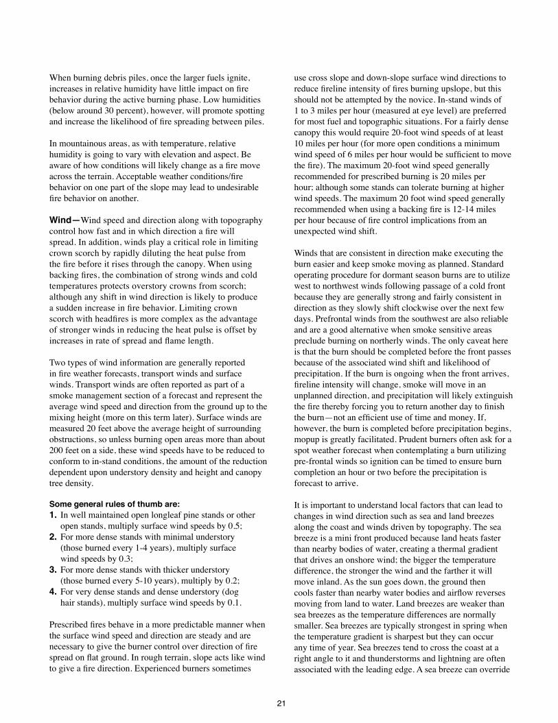
Two types of wind information are generally reported in fire weather forecasts, transport winds and surface winds Transport winds are often reported as part of a smoke management section of a forecast and represent the average wind speed and direction from the ground up to the mixing height (more on this term later) Surface winds are measured 20 feet above the average height of surrounding obstructions, so unless burning open areas more than about 200 feet on a side, these wind speeds have to be reduced to conform to in-stand conditions, the amount of the reduction dependent upon understory density and height and canopy tree density
Some general rules of thumb are: 1. In well maintained open longleaf pine stands or other
open stands, multiply surface wind speeds by 0.5; 2. For more dense stands with minimal understory
(those burned every 1-4 years), multiply surface wind speeds by 0.3;
3. For more dense stands with thicker understory (those burned every 5-10 years), multiply by 0.2;
4. For very dense stands and dense understory (dog hair stands), multiply surface wind speeds by 0 1
Prescribed fires behave in a more predictable manner when the surface wind speed and direction are steady and are necessary to give the burner control over direction of fire spread on flat ground. In rough terrain, slope acts like wind to give a fire direction. Experienced burners sometimes
use cross slope and down-slope surface wind directions to reduce fireline intensity of fires burning upslope, but this should not be attempted by the novice In-stand winds of 1 to 3 miles per hour (measured at eye level) are preferred for most fuel and topographic situations For a fairly dense canopy this would require 20-foot wind speeds of at least 10 miles per hour (for more open conditions a minimum wind speed of 6 miles per hour would be sufficient to move the fire). The maximum 20-foot wind speed generally recommended for prescribed burning is 20 miles per hour; although some stands can tolerate burning at higher wind speeds The maximum 20 foot wind speed generally recommended when using a backing fire is 12-14 miles per hour because of fire control implications from an unexpected wind shift
Winds that are consistent in direction make executing the burn easier and keep smoke moving as planned Standard operating procedure for dormant season burns are to utilize west to northwest winds following passage of a cold front because they are generally strong and fairly consistent in direction as they slowly shift clockwise over the next few days Prefrontal winds from the southwest are also reliable and are a good alternative when smoke sensitive areas preclude burning on northerly winds The only caveat here is that the burn should be completed before the front passes because of the associated wind shift and likelihood of precipitation If the burn is ongoing when the front arrives, fireline intensity will change, smoke will move in an unplanned direction, and precipitation will likely extinguish the fire thereby forcing you to return another day to finish the burn—not an efficient use of time and money. If, however, the burn is completed before precipitation begins, mopup is greatly facilitated Prudent burners often ask for a spot weather forecast when contemplating a burn utilizing pre-frontal winds so ignition can be timed to ensure burn completion an hour or two before the precipitation is forecast to arrive
It is important to understand local factors that can lead to changes in wind direction such as sea and land breezes along the coast and winds driven by topography The sea breeze is a mini front produced because land heats faster than nearby bodies of water, creating a thermal gradient that drives an onshore wind; the bigger the temperature difference, the stronger the wind and the farther it will move inland As the sun goes down, the ground then cools faster than nearby water bodies and airflow reverses moving from land to water Land breezes are weaker than sea breezes as the temperature differences are normally smaller Sea breezes are typically strongest in spring when the temperature gradient is sharpest but they can occur any time of year Sea breezes tend to cross the coast at a right angle to it and thunderstorms and lightning are often associated with the leading edge A sea breeze can override

22
gradient wind resulting in a different wind direction Sea breeze pattern is consistent so local knowledge can provide the hour of the day it arrives at a given location; this information is used to determine whether a burn can be conducted before its arrival or to provide an ignition time if this phenomenon is to be used to move the smoke in that direction In areas of complex topography, as the day progresses the sun warms different slopes/aspects at differing rates This differential heating forces winds
to flow upslope and up valley during the day with the strongest winds typically being on southwest facing aspects A key feature of these locally driven winds is that they are just that, local phenomena Local knowledge of an area will help one better understand these local wind patterns Other local features to consider for changing wind conditions include major changes in canopy density and land use, large lakes and rivers, urban areas, transmission line rights of way and roads
Wildfire burning under fairly steady conditions
prior to sea breeze arrival.
Convergence ahead of sea breeze fronts
enhances vertical motion, making the plume
more upright, inflows into fire increase in
strength, feeding more oxygen into the fire.
Potential for spotting increases.
Small change in weather brought about just
prior to the passage of the sea breeze front was
enough to transition this fire from a wind driven
fire to a plume dominated fire.
Approach of sea breeze front can bring about rapid short term increases in fire intensity.
Fire Smoke
Sea Breeze
Approach of sea breeze front can bring about rapid short term increases in fire intensity.
23
Thunderstorms are a major problem when a prescribed burn is in progress: 1) rain may dose the fire, 2) personnel face the threat of lightning and, 3) dramatic temporary changes in wind speed and direction will take place; thunderstorm downdrafts hit the ground and spread in all directions at speeds up to 60 miles per hour resulting in sudden changes in fireline intensity and direction of fire spread. Prudent burners try to schedule growing season burns so they will be completed before daily thunderstorm activity picks up Thunderstorm outflows can travel long distances (30+ miles), particularly across the coastal plain of the southeast and can produce very abrupt wind shifts that can’t currently be forecast
When broadcast burning heavy fuel loads in open areas such as logging debris, eye-level winds over about 4 miles per hour can create control problems if a head fire is used; experienced burners can often compensate for high wind speeds by altering planned ignition patterns With piled debris, winds of 8-10 miles per hour can be tolerated, but relative humidities above 40 percent are desirable to reduce the spotting potential
In mountainous terrain, winds typically increase with height in the atmosphere. Looking at a wind profile (or at least looking at the transport wind speed) will provide information on how strong the winds are above the surface As elevation increases, the probability of exposure to these stronger winds aloft also increases
Atmospheric stability and dispersion—Atmospheric stability is the resistance of the atmosphere to vertical motion and its primary importance for prescribed burning is related to fire behavior and smoke dispersion. A stable atmosphere typically results in poor burning conditions and limits formation of a well defined convective column thereby severely stifling vertical mixing of smoke through the lower atmosphere In an unstable atmosphere, smoke and combustion products from a fire rapidly rise, forming a well defined convective column. The rising air strengthens indrafts into the fire which increase fire intensity, further strengthening the convective column While these conditions are ideal for removing smoke from the burn site and dispersing it downwind, they often bring fire behavior and containment concerns such as erratic winds, enhanced spotting and an increased potential for crowning
Inversions are very stable layers in the atmosphere that act as lids which severely limit vertical motion within that layer The most common inversions in the southeastern United States are nocturnal inversions and the upper level inversions that often mark the top of the mixed layer A nocturnal inversion forms at night as the ground cools This surface cooling also cools the adjacent atmosphere and gradually builds an inversion at the surface When the sun rises and begins heating the ground, the surface inversion is rapidly eroded The mixed layer, that region of the atmosphere adjacent to the ground, where thermally driven eddies quickly mix atmospheric conditions towards a
WIND
20-FOOT WINDSPEED IS ADJUSTED TO
MIDFLAME WINDSPEED BASED ON
PARTIALLY
SHELTERED
FUELS
UNSHELTERED
FUELS
FULLY
SHELTERED
FUELS
PARTIALLY
SHELTERED
FUELS
UNSHELTERED
FUELS
Fuel beneath
patchy timber
where it is not
well sheltered
Fuel beneath
timber that has
lost its foliage
Fuel exposed
to wind - no
overstory or
sparse
overstory
Fuel on high ridges
where trees o!er little
shelter from wind
Fuel beneath standing timber at
midslope or higher with wind
blowing at slope
Fuel sheltered beneath standing
timber with foliage on at or gentle
slope or near base of mountain with
steeper slopes
Fuel beneath timber near clearing
or clearcuts
How slope position and canopy closure influence wind speed.

24
homogeneous state, is often capped by an inversion The mixing height is defined as the distance from the ground to the base of this inversion Inversions act as barriers to vertical motion within the atmosphere and will therefore tend to limit the vertical mixing of smoke within the atmosphere However, these barriers are not impenetrable Smoke will continue to rise vertically as long as it is warmer than the surrounding air; therefore for smoke to be injected above the mixing height requires a fire with enough intensity that the ascending smoke column is warmer than the air at the top of the inversion Injecting smoke above the mixed layer is often accomplished through aerial ignition as large areas can be ignited simultaneously to produce well defined convective columns.
The Haines Index is a stability index specifically designed for fire weather that ranks both the lapse rate and the presence of dry air aloft on scales of 1-3 and then combines these values to give an index value from 2 (stable and moist) through 6 (unstable and dry) The Haines Index is primarily used on wildfires to evaluate the potential for large fire growth (index values >=5). For prescribed fires, the Haines Index provides a means to evaluate the stability with an eye towards possible control problems as the index increases
For smoke management purposes the primary tools for understanding atmospheric stability center around the mixing height, transport winds and various indices derived from these them Mixing height, as stated previously, is the height to which vigorous mixing of the atmosphere occurs and is often marked by the presence of an inversion Transport wind is the vertically averaged wind from the ground up to the mixing height A variety of indices
(ventilation index, atmospheric dispersion index and low visibility risk occurrence index) combines mixing height and transport wind to provide an estimate of the atmosphere’s ability to transport smoke Note that the availability of the indices in fire weather forecasts varies as different states may require the use of different indices
The Ventilation Index (VI) expresses the lower atmosphere’s ability to diffuse and disperse smoke and is calculated by multiplying the mixing height and transport wind speed Care should be taken in choosing acceptable ranges for mixing height and transport winds Do not consider these parameters independently The VI is a handy tool to show whether your selected values provide an acceptable level of ventilation Note that the VI is really only applicable far downwind of the source, once atmospheric eddies have mixed the smoke throughout the mixed layer
Smoke plume for a low intensity fire on a windy day with a stable atmosphere. Plume rises gradually and smoke is fairly evenly distributed between the ground and the mixing height downward of the fire.
Change in temperature structure between 0700 and 1500. Strong surface inversion at 0700 is eroded throughout the day by surface heating producing an unstable layer at the surface.

25
The Atmospheric Dispersion Index (ADI) developed by Lavdas (1986) improves upon the VI by including atmospheric stability in the calculation through the use of a surface-based climatological dispersion model The ADI rates the potential impact of a pollutant source at one end of a 50-km rectangular control volume Low values of ADI indicate poor dispersion A doubling of the ADI implies a doubling of the of dispersion effectiveness During the daytime, good values for prescribed burning range from 40 to 60 Values exceeding 60 while producing good dispersion can be accompanied by erratic fire behavior; therefore, caution should be used when burning with ADI values over 60 At night, dispersion is normally much poorer than during the day and is therefore generally evaluated on a separate scale from daytime conditions Nighttime ADI values rarely exceed a value of 10
Exercise caution for cases with high transport winds and low mixing heights as this can prevent smoke from rising vertically due to the plume being bent over, which can result in much higher than expected surface smoke concentrations At the other end of the scale, be cautious of conditions with low transport wind speeds and high mixing heights as these conditions usually coincide with a very unstable atmosphere which can lead to erratic fire behavior and containment problems
Keep in mind that forecast mixing height and transport wind values are the values expected for mid-afternoon, not
all day The mixing height increases with heating during the day and as the mixing height grows a deeper layer of the atmosphere is considered in the calculation of the transport winds After sunset the mixing height decreases fairly quickly If you are starting a burn before noon, it may be a good idea to ask for a spot weather forecast that includes information on expected mixing height and transport wind information for mid-morning from the National Weather Service or other weather provider
A special note needs to be made for evaluating nighttime conditions with regard to stability and the potential for fog (or a mixture of smoke and fog) A separate index, the Low Visibility Occurrence Risk Index or LVORI, combines the ADI with maximum nighttime relative humidity to estimate the likelihood of smoke or fog being reported at a roadway accident site (Lavdas and Achtemeier, 1995) The index ranges from 1 (few smoke/fog related accident occurred under these conditions) to 10 (majority of smoke/fog related accidents occurred under these conditions) It should be noted that the LVORI was developed using accident records from Florida; therefore its applicability in other regions may be questioned From a meteorological perspective the LVORI as developed should apply for the coastal plain of the southeast but may not be applicable in the mountains Other criteria to consider when evaluating the potential for fog or nighttime smoke problems include: clear skies, moist ground, light winds, and dew point and low temperature within 2 °F of each other
Smoke plume for a high intensity fire on a windy day with an unstable atmosphere. Plume rises rapidly and penetrates above the mixing height. Most of the smoke is at or above the mixing height and will gradually mix back down toward the ground later in the day.

26
For debris burning, strong convection over cleared areas burned for site preparation of slash disposal helps vent smoke into the upper atmosphere A convection column will continue to rise until it cools to the temperature of the surrounding air or encounters a sufficiently strong inversion layer A strong convection column also forms surface level indrafts that help confine the fire to its prescribed
area and allow burn crew to clearly see along control lines and quickly attack any slopovers Be on the alert for large pieces of burning fuel sucked into the column that are still smoldering when they drop to the ground at some distance downwind; burning with relative humidity above 45 percent will virtually eliminate this potential problem unless the material is still flaming.
Table of Ventilation Index values, red values represent poor ventilation (<25,800 sq ft per second), yellow values are fair levels of ventilation (25,800-38,750 sq ft per second), and green values are good ventilation (>38,750 sq ft per second).
Table of average ADI values for moderately unstable conditions, red values represent poor dispersion (<=20), yellow values are fair dispersion (21-40), and green values are good dispersion (>40). The ADI is a function of stability and this table only shows ADI values assuming a moderately unstable atmosphere. If actual conditions are more stable (or unstable) the actual ADI values would be lower (or higher) than those in the table. If available fuel load exceeds about 3 tons/acre and burn unit size is more than a couple of acres, only burn when the forescast ADI is in the green zone.

27
Whenever a burn is conducted in mountainous terrain, diurnal slope winds must be considered As soon as the slope is heated by the morning sun, an upslope breeze results which will increase in strength into the early afternoon. Igniting a fire at the base of the slope during the day will allow the heat of the fire to work with the heated slope to provide extra lift to the smoke, increasing chances of venting smoke above the mixed layer but be exceeding cautious when contemplating this tactic because fireline intensity will continue to rapidly increase until the crest/ridgeline is reached generally resulting in crown scorch, bole damage and containment problems unless the control line is located 50-100 feet downhill over the ridge At night surface cooling drives wind and residual smoke downslope as mentioned above, concentrating smoke in low lying areas
When using aerial ignition techniques at the high end of the prescription window it is possible to ignite too much area too quickly; which can combine with an unstable atmosphere to enhance spotting, crowning and other indicators of erratic fire behavior. The prudent burn boss will temporarily halt ignition and assess behavior of the first row or two of spot fires before deciding whether to adjust ignition pattern, change firing technique, terminate the burn, or continue as planned
Rainfall and drought—Rainfall prior to a prescribed burn is extremely important as it affects both fuel moisture and soil moisture Damp soil protects tree roots and microorganisms Even when burning to expose a mineral soil seedbed, it is desirable to leave a thin layer of organic material Burning should cease during periods of prolonged
Atmospheric Dispersion Index (ADI)
RH 1 2 3-4 5-6 7-8 9-10 11-12 13-16 17-25 26-30 31-40 > 40
< 55 2 2 2 2 2 2 2 2 2 2 1 1
55-59 3 3 3 3 3 2 2 2 2 2 1 1
60-64 3 3 3 3 3 3 2 2 2 2 1 1
65-69 4 3 3 3 3 3 3 3 3 3 3 1
70-74 4 3 3 3 3 3 3 3 3 3 3 3
75-79 4 4 4 4 4 4 4 4 3 3 3 3
80-82 6 5 5 4 4 4 4 4 3 3 3 3
83-85 6 5 5 5 4 4 4 4 4 4 4 4
86-88 6 6 6 5 5 5 5 4 4 4 4 4
89-91 7 7 6 6 5 5 5 5 4 4 4 4
92-94 8 7 6 6 6 6 5 5 5 4 4 4
95-97 9 8 8 7 6 6 6 5 5 4 4 4
> 97 10 10 9 9 8 8 7 5 5 4 4 4
Table of LVORI values as a function of Atmospheric Dispersion Index and Relative Humidity. Green = conditions with lowest proportion of accidents. White = proportion of accidents increased by a factor of 2-10 over green. Yellow= proportion of accidents increased by a factor of 10-40 over green. Orange = proportion of accidents increased by a factor of 40-150 over green.
Visual Indicators of Atmospheric Stability
Stable Unstable
Clouds in layers, stratus type clouds Clouds grow vertically, cumulus type clouds
Smoke columns drift apart after limited rise Smoke columns rise to great heights
Poor visibility due to haze or smoke Good visibility
Fog Dust devils and firewhirls form
Steady winds Gusty surface winds

28
KBDI and Prescribed Fire Guidelines
KBDI Range Notes
0–100 Conditions generally so wet fires will go out.
Too wet to accomplish most prescribed burn objectives.
100–200 Marginal conditions for most understory burns.
100- and 1000-hour fuels do not contribute to fire intensity.
Most soil organic material, duff and lower litter layers left intact.
Some re-ignition likely needed for burns to meet objectives.
Good range for re-introductory fires after long periods of exclusion. Minimal mopup required.
Smoke management focused on the period of the burn as little smoldering is expected. Any depression likely to stop fire spread resulting in patchy burns.
Natural features such as creeks are effective control lines.
Fires can still be quite intense as KBDI is not an indicator of 1- and 10-hour fuel moisture contents.
200–400 Lower litter and duff layers begin to show signs of water loss and contribute to fire intensity.
Expect an overall increase in fuel consumption.
Smoldering more of a concern for smoke management as larger fuels are more likely to ignite and duff/litter layers may also contribute to residual smoke.
Evaluate all line conditions, especially any natural barriers. Ensure that lines are clear of debris that would allow the fire to creep across.
400–500 Most likely in late summer/early fall (Florida with its summer rainy season being one exception).
Very intense fires are likely in this range.
Most duff and litter will be consumed, exposing mineral soil in many cases.
Where duff is colonized by feeder roots expect increasing damage.
Consider postponing burns where a duff layer is present.
Mortality should be expected from fire as Index approaches 500.
Less residual smoke because less moisture in fuel allows more flaming consumption and thus less smoldering after passage of flame front.
All but the largest dead fuels will be consumed.
Long term smoldering will contribute to smoke management problems.
Control problems from spotting are likely.
Live fuel moistures will drop making ignition of understory vegetation easier.
500-600 Transition to extreme fire behavior conditions
Significant tree mortality should be expected where duff is present.
Most components of the fuel bed will burn intensely.
Stop all prescribed fire activity.
Expect all fires to harm the ecosystem.
Rest crews for wildfire suppression.
Limit annual leave to family emergencies.
600– Expect extensive overstory mortality in all species except pond pine & Melaleuca.

29
drought (KBDI [see below] above 450 on all but sandy sites with well-maintained longleaf where cutoff is around 550—consult with local forestry agency for more area specific thresholds) and resume only after a soaking rain of at least 1 inch. When the KBDI is below these threshold levels a quarter to half inch of rain followed by sunny skies, brisk winds and low humidity will generally result in several days of good prescribed fire conditions with adequate soil and feeder-root protection
On clay soils, such as found in the piedmont, much of the rainfall is lost through runoff, and duration is more important than amount An inch of rain occurring in half an hour will not produce the same soil moisture benefits as a half inch of rain over a two hour period Even on sandy Coastal Plain sites, small diameter fuels less than ½ inch in diameter will become saturated after just a few minutes of rain, but logs larger than 3 inches in diameter require a soaking rain lasting several hours to approach saturation
Debris burning—Generally rain has a greater impact on fuel moisture in cleared areas than under a canopy as no rain is lost to interception by the canopy However, fuels in the open also tend to dry faster due to direct exposure to sunlight and higher wind speeds Burn cleared areas after a hard rain while fuels in surrounding forested areas are still damp Mountain burners often ignite open areas while adjacent timbered areas still have a blanket of snow When burning cleared areas, soil damage is as much a function of fire intensity and duration as it is soil moisture. Intense, long duration fires will bake the soil regardless of the moisture present at ignition Both the chemical and physical properties of the soil can be altered. Undesirable fire effects are often produced when burning windrowed or piled debris which is one reason that windrowing slash prior to burning is not recommended; piles, if constructed, should be less than 10-12 feet in diameter and piled using a root rake when both soil and fuel are dry
The Keetch-Byram Drought Index (KBDI) is one tool available for assessing soil/duff moisture conditions The KBDI is based on the notion that the upper soil and duff layer have a moisture capacity of eight inches at saturation At saturation the KBDI has a value of zero, reflecting zero moisture deficit. A KBDI of 800 reflects a moisture deficit of 8 inches or a complete lack of moisture in the theoretical soil layer. The KBDI is designed to be easily calculated and only requires information on mean annual rainfall, daily rainfall and maximum daily temperature
Care should be taken in interpreting KBDI values as fire behavior can differ for a given value of the index For example, a value of 400 can indicate a prolonged period of drying during which the Index has steadily increased which indicates that an intense burn may cause some feeder-root
damage However, a value of 400 can also be achieved by having received over an inch of rain when the KBDI was around 500. In the case where a KBDI of 400 was achieved through a rapid drop due to heavy rains, a brief window of adequate soil moisture for burning may occur, provided there are only 1-2 large (3+ inches in diameter) down logs or stumps per acre These larger fuels may appear wet on the surface, but they are dry in the middle and if the fire gets through this moist layer, the fuels will ignite and smolder for days creating horrendous smoke management problems
Information on the KBDI can be obtained from local state forestry agencies. Note that since the KBDI depends on rainfall information there can be a great deal of spatial variability in the value over short distances when areas have been experiencing isolated to scattered shower activity
Precipitation and drought conditions after the burn should be considered as well as conditions leading up to the burn Fire is a stress on the stand and additional stress in the form of drought after a burn can seriously damage a stand Consult long range (seasonal) weather forecasts available from the National Weather Service or state forestry agency to assess the potential for below normal rainfall over the next few months
Fuel considerations—Fine fuel moisture is strongly influenced by rainfall, relative humidity and temperature. The preferred range in fine fuel moisture of the upper litter layer (the surface layer of freshly fallen needles and leaves) is from 8 to 15 percent This range is deliberately conservative and broad to encompass a wide range of ecosystems. When fine fuel moisture levels reach around 7 percent damage to plant roots and soil is a possibility and postponing the burn should be considered as spot fires will become problematic and fire control will be a major issue Moisture levels exceeding 16 percent in hardwood stands and 20 percent for conifers can result in overly patchy, incomplete burns that do not accomplish the desired objectives However, such high fuel moisture levels can be desirable for heavy fuel loads to keep fire intensity manageable, especially if aerial ignition is to be used Note that fine fuel moisture levels obtained from the National Fire Danger Rating System (NFDRS) or fire behavior tables tend to be lower than actual values as they reflect worst case conditions
Tables can be used to estimate fine fuel moisture content. While some tables only require temperature and relative humidity to provide an estimated fuel moisture content, others require information such as time of day and season and the degree of fuel shading. Accurate estimates of fine fuel moisture content are very important, as a 5-percent error in fine fuel moisture content can lead to as much as a 50-percent increase in the estimated rate of fire spread. A
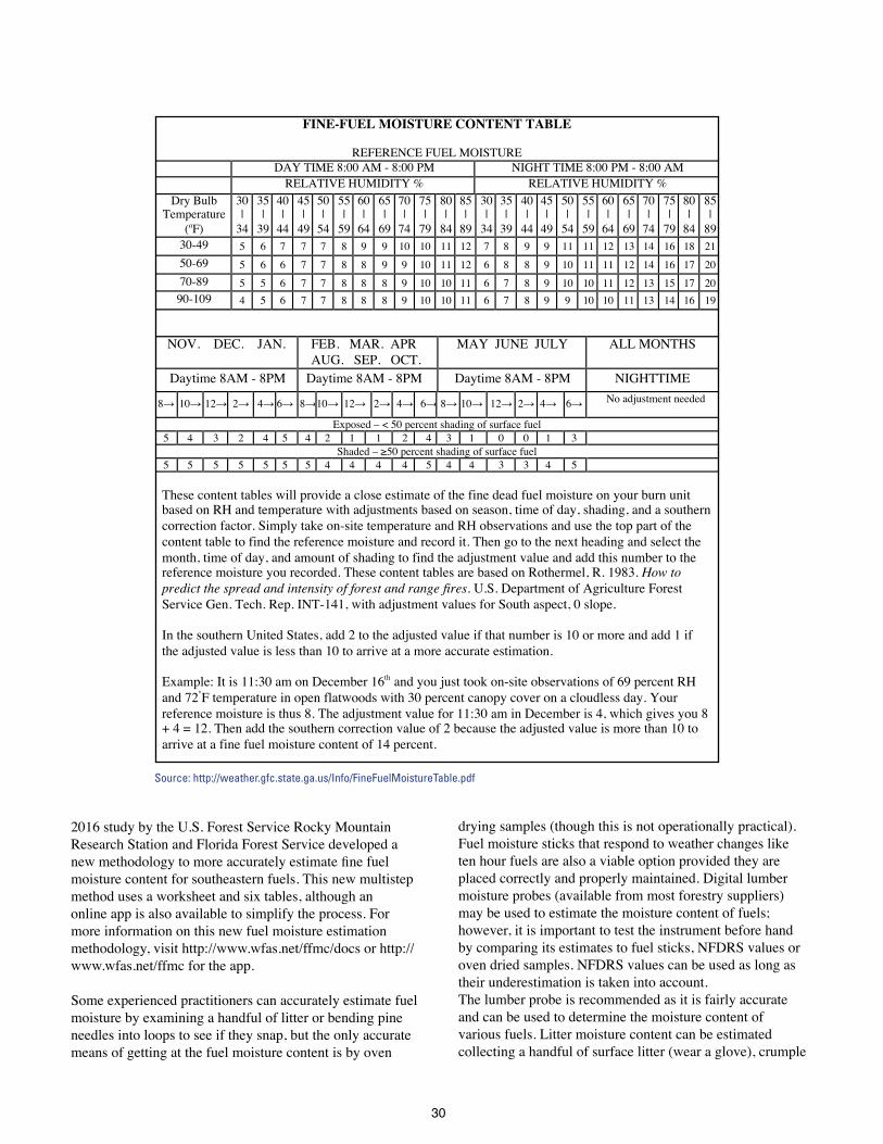
30
2016 study by the U S Forest Service Rocky Mountain Research Station and Florida Forest Service developed a new methodology to more accurately estimate fine fuel moisture content for southeastern fuels This new multistep method uses a worksheet and six tables, although an online app is also available to simplify the process For more information on this new fuel moisture estimation methodology, visit http://www wfas net/ffmc/docs or http://www wfas net/ffmc for the app
Some experienced practitioners can accurately estimate fuel moisture by examining a handful of litter or bending pine needles into loops to see if they snap, but the only accurate means of getting at the fuel moisture content is by oven
drying samples (though this is not operationally practical) Fuel moisture sticks that respond to weather changes like ten hour fuels are also a viable option provided they are placed correctly and properly maintained Digital lumber moisture probes (available from most forestry suppliers) may be used to estimate the moisture content of fuels; however, it is important to test the instrument before hand by comparing its estimates to fuel sticks, NFDRS values or oven dried samples NFDRS values can be used as long as their underestimation is taken into account The lumber probe is recommended as it is fairly accurate and can be used to determine the moisture content of various fuels Litter moisture content can be estimated collecting a handful of surface litter (wear a glove), crumple
FINE-FUEL MOISTURE CONTENT TABLE
REFERENCE FUEL MOISTURE
DAY TIME 8:00 AM - 8:00 PM NIGHT TIME 8:00 PM - 8:00 AM RELATIVE HUMIDITY % RELATIVE HUMIDITY %
Dry Bulb Temperature
(oF)
30 |
34
35 |
39
40 |
44
45 |
49
50 |
54
55 |
59
60 |
64
65 |
69
70 |
74
75 |
79
80 |
84
85 |
89
30 |
34
35 |
39
40 |
44
45 |
49
50 |
54
55 |
59
60 |
64
65 |
69
70 |
74
75 |
79
80 |
84
85 |
89 30-49 5 6 7 7 7 8 9 9 10 10 11 12 7 8 9 9 11 11 12 13 14 16 18 21 50-69 5 6 6 7 7 8 8 9 9 10 11 12 6 8 8 9 10 11 11 12 14 16 17 20 70-89 5 5 6 7 7 8 8 8 9 10 10 11 6 7 8 9 10 10 11 12 13 15 17 20 90-109 4 5 6 7 7 8 8 8 9 10 10 11 6 7 8 9 9 10 10 11 13 14 16 19
NOV. DEC. JAN. FEB. MAR. APR AUG. SEP. OCT.
MAY JUNE JULY ALL MONTHS
Daytime 8AM - 8PM Daytime 8AM - 8PM Daytime 8AM - 8PM NIGHTTIME
8→ 10→ 12→ 2→ 4→ 6→ 8→ 10→ 12→ 2→ 4→ 6→ 8→ 10→ 12→ 2→ 4→ 6→ No adjustment needed
Exposed – < 50 percent shading of surface fuel 5 4 3 2 4 5 4 2 1 1 2 4 3 1 0 0 1 3
Shaded – ≥50 percent shading of surface fuel 5 5 5 5 5 5 5 4 4 4 4 5 4 4 3 3 4 5 These content tables will provide a close estimate of the fine dead fuel moisture on your burn unit based on RH and temperature with adjustments based on season, time of day, shading, and a southern correction factor. Simply take on-site temperature and RH observations and use the top part of the content table to find the reference moisture and record it. Then go to the next heading and select the month, time of day, and amount of shading to find the adjustment value and add this number to the reference moisture you recorded. These content tables are based on Rothermel, R. 1983. How to predict the spread and intensity of forest and range fires. U.S. Department of Agriculture Forest Service Gen. Tech. Rep. INT-141, with adjustment values for South aspect, 0 slope. In the southern United States, add 2 to the adjusted value if that number is 10 or more and add 1 if the adjusted value is less than 10 to arrive at a more accurate estimation. Example: It is 11:30 am on December 16th and you just took on-site observations of 69 percent RH and 72°F temperature in open flatwoods with 30 percent canopy cover on a cloudless day. Your reference moisture is thus 8. The adjustment value for 11:30 am in December is 4, which gives you 8 + 4 = 12. Then add the southern correction value of 2 because the adjusted value is more than 10 to arrive at a fine fuel moisture content of 14 percent.
Source: http://weather.gfc.state.ga.us/Info/FineFuelMoistureTable.pdf

31
it to get rid of air spaces and stick it with the probe; take several samples including lower litter/upper duff Use the probe consistently to build a mental database of the affect that estimated fuel moisture content (using the probe) has on fire behavior.
Do not just check the moisture condition of the upper litter/duff but also check lower layers as well Dry conditions in the lower litter/duff often follow prolonged drought periods (high KBDI values). Fires following prolonged dry periods can often burn with unexpected intensity When burning on organic soils, this phenomenon can have drastic consequences. If the fire dries the moist surface layer of litter/duff, the underlying organic layer can ignite; leading to a fire with the potential to smolder for weeks is spite of control efforts, causing extensive smoke problems
The prudent burner checks the moisture condition of the upper litter in sun and shade as well as the duff layer if present, and dead logs of various sizes Dry conditions in the lower litter/duff often follow prolonged drought periods (high KBDI values); and once the damper surface litter is ablaze, these lower layers will likely burn with unexpected intensity and undesirable results such as feeder root damage When burning on organic soils, this phenomenon can have drastic consequences. If the fire dries the moist surface layer of litter/duff, the underlying organic layer can ignite; leading to a fire with the potential to smolder for weeks is spite of control efforts, causing extensive smoke problems Once ignited, organic soil requires vast amounts of water to extinguish These soils are consumed through smoldering, not flaming, combustion and often show little evidence that they are burning at first as the horizontal rate of spread for organic soil fires is measured in inches per hour Extensive smoke problems are almost guaranteed when organic soils are involved; therefore burning in areas with organic soils is not recommended for the novice burner; consult with your local forestry agency.
How fuels respond to changes in relative humidity is a complex process that depends on fuelbed characteristics and recent weather conditions Different fuel types can reach different fine fuel moisture levels under the same humidity conditions Because of these complexities and natural variability across a landscape, recommended fine fuel moisture values are only guidelines. On-the-ground knowledge of fuels must be incorporated into the prescription
Fuel moisture influences smoke production. Damp fuels release large amounts of dense white smoke, which is mostly condensed water vapor These water droplets are very efficient at scattering light and thereby reducing visibility
For most prescribed fires the preferred fine fuel moisture 8 to 15 percent.
Harvested areas should be burned when dry as the object is to consume large fuels They will ignite easier, burn more quickly and completely, shortening the time needed to complete the burn. Aggressive firing techniques such as aerial ignition or ground ignition using a ring fire with center ignition as well should be strongly considered Often less mopup is required and the impact on air quality is reduced Short but severe drought periods common during the summer in the southeast provide ideal burning conditions on cleared areas, provided soil moisture levels do not get too low and the fire can be confined to the burn unit.
To avoid damage to the site, do not windrow harvest debris Consider burning debris as it lies (broadcast burned), although constructing small circular piles with a root rake when the debris has had time to cure (it won’t dry well when piled) and when the fuel and ground is dry to minimize soil in the piles, will result in much better Moisture of 10-hour fuels can be measured with fuel moisture sticks.
Effects of humidity and days since rain on fine-fuel moisture.

32
consumption of larger fuels It takes a month or two after cutting for the severed tops to cure Once the needles turn a greenish-yellow and hardwood leaves have withered, the debris is ready to burn
Because fuels on logged areas receive full solar radiation, they dry more quickly than the surrounding forested area so once fully cured, burning can be safely done shortly after a rain For slash fuels, ten hour fuel moisture values (fuels ¼ to 1 inch in diameter, such as small branches and stems) are a better indicator of burning conditions than fine fuel moisture. Fuel moisture sticks will generally give excellent results Place one set of sticks in the area to be burned and another in the adjacent forested area Allow the sticks to acclimate for at least two weeks The logged area is considered ready to burn when the moisture content is around 10 percent, provided the forest area is still above 15 percent
If larger fuels need to be consumed (those over 2 to 3 inches), piling will probably be necessary Piling in wet weather should be avoided. Keep the piles small and free of dirt Allow fresh logging debris to cure for several weeks before piling because drying conditions within the piles are extremely poor Much of the smoke problems associated with burning piled debris is caused by the inefficient combustion of damp, soil-laden piles These piles can smolder for weeks
Fine fuel moisture values can be used to estimate the probability ignition to help the practitioner better understand the potential for embers igniting spot fires outside of the burn unit Probability of ignition is determined using the table above which requires the fine fuel moisture, temperature and percent shading of the fuels (shading includes shade from both canopy and clouds)
Probability of Ignition Fine Dead Fuel Moisture (percent) Shading
(percent)
Temp
° F 2 3 4 5 6 7 8 9 10 11 12 13 14 15 16 17
110+ 100 100 80 70 60 60 50 40 40 30 30 20 20 20 20 10
100-
109 100 90 80 70 60 60 50 40 40 30 30 20 20 20 10 10
90-
99 100 90 80 70 60 60 40 40 30 30 30 20 20 20 10 10
80-
89 100 90 80 70 60 50 40 40 30 30 20 20 20 10 10 10
70-
79 100 80 70 60 60 50 40 40 30 30 20 20 20 10 10 10
60-
69 90 80 70 60 50 50 40 30 30 20 20 20 20 10 10 10
50-
59 90 80 70 60 50 40 40 30 30 20 20 20 10 10 10 10
40-
49 90 80 70 60 50 40 40 30 30 20 20 20 10 10 10 10
Unshaded
< 50%
30-
39 80 70 60 50 50 40 30 30 20 20 20 10 10 10 10 10
110+ 100 90 80 70 60 50 50 40 40 30 30 20 20 20 10 10
100-
109 100 90 80 70 60 50 50 40 30 30 30 20 20 20 10 10
90-
99 100 90 80 70 60 50 40 40 30 30 20 20 20 10 10 10
80-
89 100 80 70 60 60 50 40 40 30 30 20 20 20 10 10 10
70-
79 90 80 70 60 50 50 40 30 30 30 20 20 20 10 10 10
60-
69 90 80 70 60 50 40 40 30 30 20 20 20 10 10 10 10
50-
59 90 80 70 60 50 40 40 30 30 20 20 20 10 10 10 10
40-
49 90 80 60 50 50 40 30 30 30 20 20 20 10 10 10 10
Shaded
> 50%
30-
39 80 80 60 50 50 40 30 30 20 20 20 10 10 10 10 10

33
Duff moisture —Owing to the potential for prolonged emissions and severe fire effects from the smoldering combustion of organic soils and mineral soils with thick organic horizons, organic soil moisture is an important management concern for fire practitioners. The Estimated Smoldering Potential provides fire practitioners a means to assess the likelihood of sustained smoldering in organic soils that possess mineral content less than 10 percent
Burning in areas with organic soils is beyond the skills/experience of the novice burner; consult with local forestry agency in both the planning and execution of the burn to help insure that these soils do not ignite Estimated smoldering probabilities should be 30 percent or less and the water table should be at the surface
COLLECTING AND USING WEATHER INFORMATION ON THE BURN
Knowledge of the weather is the key to successful prescribed burning, and is mandatory for proper smoke management Weather information is included in the prescription to help define the fire behavior best suited for accomplishing the burn’s objectives In preparing for the burn it is vital to monitor weather forecasts to ensure that weather elements will be within prescription and during the burn weather conditions should be monitored to verify that conditions remain within prescription Remember to document all weather observations as an important part of the burn process as this information can be valuable in evaluating burn objectives and fire effects. These records can also aid in refining future prescriptions. They should be stored along with the unit prescription as vital documents
Routine weather observations should be made at the burn site before, during and after the fire. Such observations are important as they serve as a check on the applicability of
the weather forecast and help keep the burn crew apprised of any local weather influences or changes. Also, keeping good weather observations during the fire is essential to understanding the fire impacts during post-fire monitoring. Make observations at hourly intervals and whenever changes in fire behavior are noticed. Take measurements in the burn unit or in fuels adjacent to the unit if heat from the fire may influence the readings. Measurements taken in open areas and within a stand are likely to be different Observations can be made using a belt weather kit, digital handheld instruments (Kestrels as an example) or a portable weather station If using a handheld digital instrument or portable weather station it is critical that the instruments be calibrated on a regular basis as prescribed by the manufacturer
Weather forecasts are a critical part of the prescribed burning process and can be obtained from the National Weather Service (NWS), State forestry agencies, or private weather forecasting services. It is important to get a fire weather forecast and not the common public forecast provided through the local media as the public forecast will lack the detailed information needed for a prescribed burn, particularly smoke management information such as mixing height and transport winds. The contents of fire weather NWS forecasts can vary by office as the contents of the forecast are typically agreed upon by local land management agencies and NWS as part of a fire weather operating plan.
Estimated Smoldering Potential (ESP) of root mat soils expressed as a percent based on soil moisture and mineral content.
Standard belt weather kit.
Kestrel pocket weather meter.
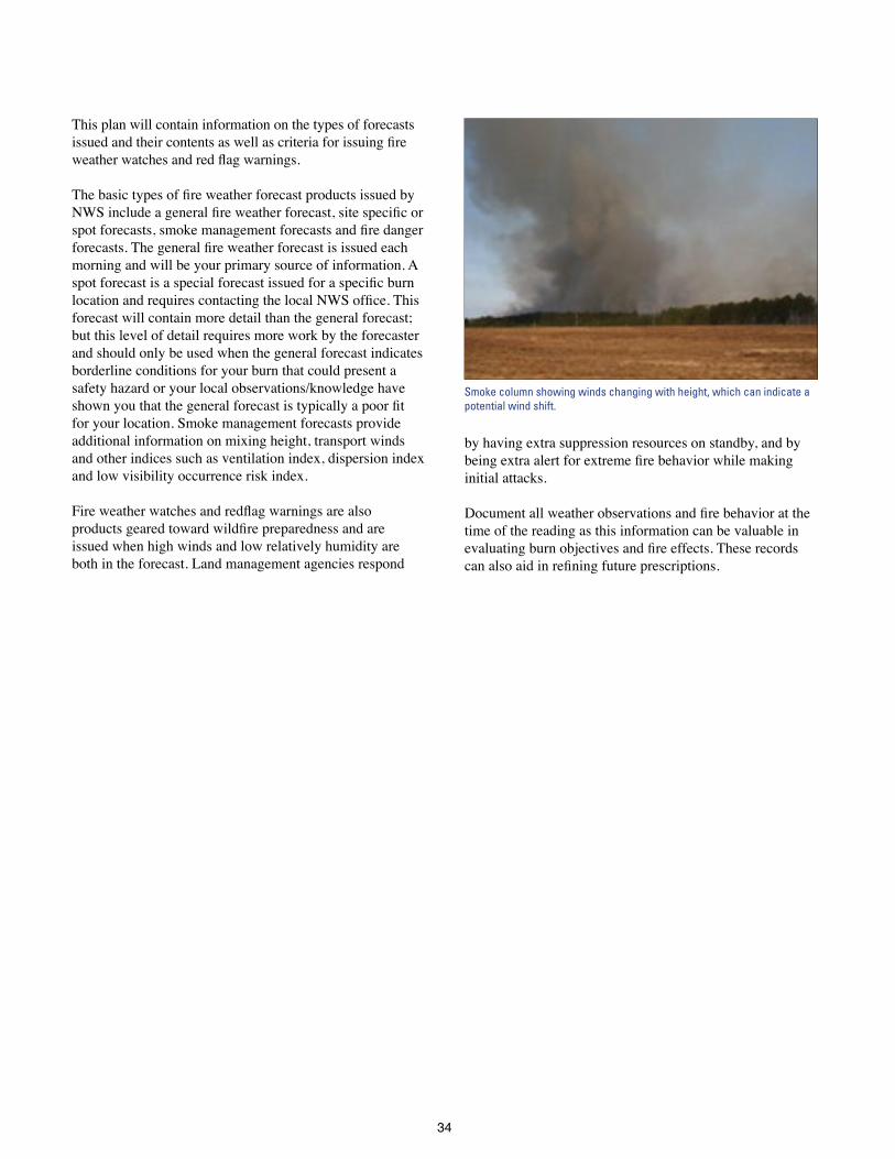
34
This plan will contain information on the types of forecasts issued and their contents as well as criteria for issuing fire weather watches and red flag warnings.
The basic types of fire weather forecast products issued by NWS include a general fire weather forecast, site specific or spot forecasts, smoke management forecasts and fire danger forecasts. The general fire weather forecast is issued each morning and will be your primary source of information A spot forecast is a special forecast issued for a specific burn location and requires contacting the local NWS office. This forecast will contain more detail than the general forecast; but this level of detail requires more work by the forecaster and should only be used when the general forecast indicates borderline conditions for your burn that could present a safety hazard or your local observations/knowledge have shown you that the general forecast is typically a poor fit for your location Smoke management forecasts provide additional information on mixing height, transport winds and other indices such as ventilation index, dispersion index and low visibility occurrence risk index
Fire weather watches and redflag warnings are also products geared toward wildfire preparedness and are issued when high winds and low relatively humidity are both in the forecast Land management agencies respond
by having extra suppression resources on standby, and by being extra alert for extreme fire behavior while making initial attacks
Document all weather observations and fire behavior at the time of the reading as this information can be valuable in evaluating burn objectives and fire effects. These records can also aid in refining future prescriptions.
Smoke column showing winds changing with height, which can indicate a potential wind shift.
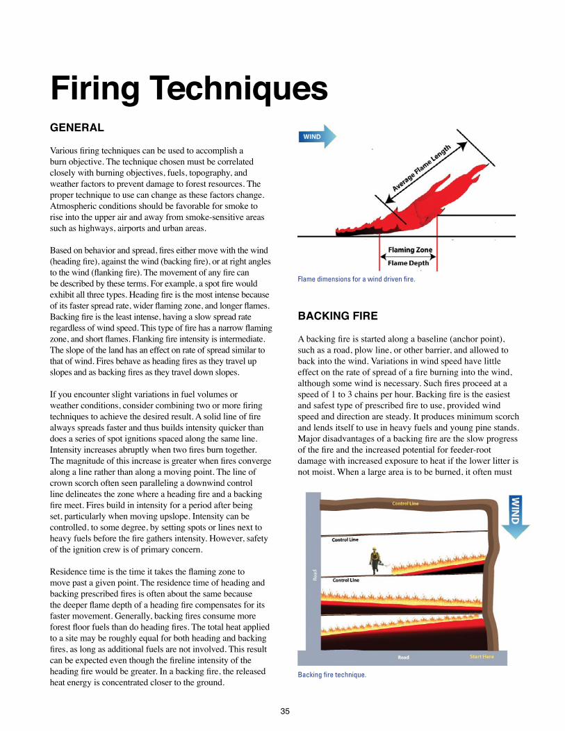
35
Firing TechniquesGENERAL
Various firing techniques can be used to accomplish a burn objective The technique chosen must be correlated closely with burning objectives, fuels, topography, and weather factors to prevent damage to forest resources The proper technique to use can change as these factors change Atmospheric conditions should be favorable for smoke to rise into the upper air and away from smoke-sensitive areas such as highways, airports and urban areas
Based on behavior and spread, fires either move with the wind (heading fire), against the wind (backing fire), or at right angles to the wind (flanking fire). The movement of any fire can be described by these terms. For example, a spot fire would exhibit all three types. Heading fire is the most intense because of its faster spread rate, wider flaming zone, and longer flames. Backing fire is the least intense, having a slow spread rate regardless of wind speed. This type of fire has a narrow flaming zone, and short flames. Flanking fire intensity is intermediate. The slope of the land has an effect on rate of spread similar to that of wind. Fires behave as heading fires as they travel up slopes and as backing fires as they travel down slopes.
If you encounter slight variations in fuel volumes or weather conditions, consider combining two or more firing techniques to achieve the desired result. A solid line of fire always spreads faster and thus builds intensity quicker than does a series of spot ignitions spaced along the same line Intensity increases abruptly when two fires burn together. The magnitude of this increase is greater when fires converge along a line rather than along a moving point The line of crown scorch often seen paralleling a downwind control line delineates the zone where a heading fire and a backing fire meet. Fires build in intensity for a period after being set, particularly when moving upslope Intensity can be controlled, to some degree, by setting spots or lines next to heavy fuels before the fire gathers intensity. However, safety of the ignition crew is of primary concern
Residence time is the time it takes the flaming zone to move past a given point The residence time of heading and backing prescribed fires is often about the same because the deeper flame depth of a heading fire compensates for its faster movement. Generally, backing fires consume more forest floor fuels than do heading fires. The total heat applied to a site may be roughly equal for both heading and backing fires, as long as additional fuels are not involved. This result can be expected even though the fireline intensity of the heading fire would be greater. In a backing fire, the released heat energy is concentrated closer to the ground
BACKING FIRE
A backing fire is started along a baseline (anchor point), such as a road, plow line, or other barrier, and allowed to back into the wind Variations in wind speed have little effect on the rate of spread of a fire burning into the wind, although some wind is necessary. Such fires proceed at a speed of 1 to 3 chains per hour. Backing fire is the easiest and safest type of prescribed fire to use, provided wind speed and direction are steady It produces minimum scorch and lends itself to use in heavy fuels and young pine stands Major disadvantages of a backing fire are the slow progress of the fire and the increased potential for feeder-root damage with increased exposure to heat if the lower litter is not moist When a large area is to be burned, it often must
Flame dimensions for a wind driven fire.
Backing fire technique.
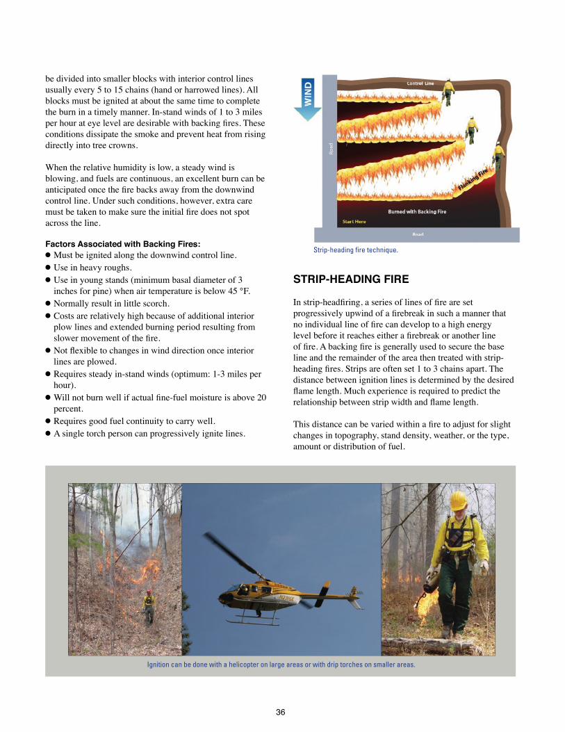
36
be divided into smaller blocks with interior control lines usually every 5 to 15 chains (hand or harrowed lines) All blocks must be ignited at about the same time to complete the burn in a timely manner In-stand winds of 1 to 3 miles per hour at eye level are desirable with backing fires. These conditions dissipate the smoke and prevent heat from rising directly into tree crowns
When the relative humidity is low, a steady wind is blowing, and fuels are continuous, an excellent burn can be anticipated once the fire backs away from the downwind control line Under such conditions, however, extra care must be taken to make sure the initial fire does not spot across the line
Factors Associated with Backing Fires:l Must be ignited along the downwind control line l Use in heavy roughs l Use in young stands (minimum basal diameter of 3
inches for pine) when air temperature is below 45 °F l Normally result in little scorch l Costs are relatively high because of additional interior
plow lines and extended burning period resulting from slower movement of the fire.
l Not flexible to changes in wind direction once interior lines are plowed
l Requires steady in-stand winds (optimum: 1-3 miles per hour)
l Will not burn well if actual fine-fuel moisture is above 20 percent
l Requires good fuel continuity to carry well l A single torch person can progressively ignite lines
STRIP-HEADING FIRE
In strip-headfiring, a series of lines of fire are set progressively upwind of a firebreak in such a manner that no individual line of fire can develop to a high energy level before it reaches either a firebreak or another line of fire. A backing fire is generally used to secure the base line and the remainder of the area then treated with strip-heading fires. Strips are often set 1 to 3 chains apart. The distance between ignition lines is determined by the desired flame length. Much experience is required to predict the relationship between strip width and flame length.
This distance can be varied within a fire to adjust for slight changes in topography, stand density, weather, or the type, amount or distribution of fuel
Ignition can be done with a helicopter on large areas or with drip torches on smaller areas.
Strip-heading fire technique.

37
Compensation for minor wind direction changes can be made by altering the angle of strip fire with the base line. Treat major changes in fuel type separately
An effective method of reducing fire intensity is to use a series of spots or short 1- to 2-foot-long strips instead of a solid line of fire. An added advantage of these short strips or spots is that driptorches will not have to be filled as often. Strip-heading fires permit quick ignition and burnout, and provide for smoke dispersal under optimum conditions However, higher intensities will occur wherever lines of fire burn together, increasing the likelihood of crown scorch
Occasionally, on areas with light and even fuel distribution, a heading fire may be allowed to move over the entire area without stripping to better accomplish the objective(s) This method reduces the number of areas of increased fire intensity that occur each time two fires burn together.
CAUTION: Be sure the fire will not escape control. First set a backing fire along the downwind control line and allow it to burn a strip wide enough to control the heading fire.
Factors Associated with Strip-heading Fires: l Secure the downwind base line before igniting a
heading fire. l Cost is lower than other line-firing techniques because
fire progress is rapid and few plow lines are required. l Needs just enough wind to give direction (1 to 2 miles
per hour in-stand) l Do not use in heavy roughs. Consider backing or flanking
techniques if fire-free interval exceeds 3 years or if understory vegetation is taller than 3 to 4 feet
l The technique can accommodate wind shifts up to about 45 degrees
l Winter use is best because cool weather (below 60 °F) helps avoid crown scorch
l Flame lengths can be high whenever heading fire converges with a backing fire, thereby increasing the possibility of crown scorch
l Can be used in a wide range of forest types depending on management objectives
l A single torch person can progressively ignite strips l Do not force a burn on a marginal day at the low end of
the prescription window. The fire may burn slowly until after the crew leaves, then pick up intensity and escape
l Can be used in “flat” fuels such as hardwood leaves. l Because fire movement is fast, large blocks can be
burned l Can be used with high relative humidity (50 to
60 percent) and high actual fine-fuel moisture (20 to 25 percent)
FLANKING FIRE
The flanking-fire technique consists of treating an area with lines of fire set directly into the wind. The lines spread at right angles to the wind This technique requires considerable knowledge of fire behavior, particularly if used by itself. It is used quite often to secure the flanks of a strip-heading fire or backing fire as it progresses. It is sometimes used to supplement a backing fire in areas of light fuel or under more humid weather conditions It is useful on a small area or to facilitate burning a large area in a relatively short time when a strip-heading fire would be too intense.
This method of firing can stand little variation in wind direction and requires expert crew coordination and timing. For safety, all lines of flank fire should be ignited simultaneously and all torch people should keep abreast of one another
If only one or two torch people are available, this technique is usually altered to set the ignition lines 45 degrees into the wind
In hilly or mountainous terrain, any ignition line that drops perpendicularly off a ridge creates a flanking fire under no-wind conditions If several lines are ignited off the end of a ridge or knoll, the pattern looks like a chevron or maple leaf
Factors Associated with Flanking Fires:l Always secure downwind base line first. l Fuel loading should be light to medium-less than 8 tons
per acre l Wind direction must be steady
Flanking fire technique.

38
l Best used in medium-to-large sawtimber or if crown scorch is not a concern (e g hardwoods in winter)
l Allows fast area ignition l Needs few control lines l In areas with a high understory, multiple torch people
are needed and coordination is very important Use radio communications whenever torch people cannot see one another
l Useful in securing flanks of other fire types.
POINT SOURCE FIRES
A prudent burning boss will often switch from strip-heading fires to point source fires as the day progresses, relative humidity drops, and continuous lines of fire become too intense When properly executed, a grid of spot ignitions will produce a fire with intensity much greater than that of a line-backing fire but somewhat less than that of a line-heading fire. Timing and spacing of the individual ignition spots are the keys to the successful application of this method. First a line backing fire is ignited across the downwind side of the block and allowed to back 10 to 20 feet into the block to increase the effective width of the control line. A line of spots is then ignited at some specified distance upwind of the backing fire and the process continued until the whole block has been ignited
To reduce flame length, ignition-grid spacing is selected to allow the spots along a line to head into the rear of the spots along the downwind line before the flanks of the individual spots merge to form a continuous flame front. The merger of successive ignition lines thus takes place along a moving point rather than along a whole line at the same time Merger along a moving point can be ensured by beginning with a closely spaced square grid (2 chains by 2 chains is recommended)
Close spacing between lines helps the individual spots develop, but ensures that the head of one spot will burn into the rear of the downwind spot before the heading fire’s potential flame length and intensity are reached. With close spacing there will be more merging points; but a large number of small fires burning simultaneously can produce the same kind of explosive convective energy as a single large fire because too much heat energy is released too rapidly This situation is discussed under the Aerial Ignition section
Rectangular grids with wider spacing between lines than within a line should not be used initially because such a pattern may allow the spots along a line to merge into a line of heading fire before running into the rear of the downwind spots. Once the first few lines have been ignited and fire behavior has been assessed, intensity can be regulated to some extent by changing the time between ignition points within a line, the distance between points, and the distance between lines Thus the balancing act between spacing and timing has to be continually adjusted as fire behavior reacts to both temporal and spatial changes in fuel and weather
Intensity is decreased by widening the interval between ignition points along a line. If fireline intensity is still too high after doubling this interval while maintaining a 2-chain distance between lines, firing should be halted. Allow the area to burn with a backing fire or plow it out. Although intensity at the head of an individual spot is increased by widening the distance between lines, the average intensity of the burn as a whole is usually somewhat lower Check
Grid, or point source ignition technique. Point source ignitions.
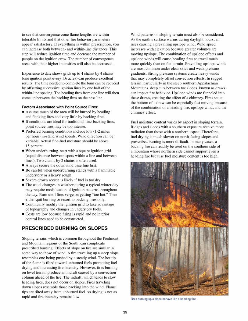
39
to see that convergence-zone flame lengths are within tolerable limits and that other fire behavior parameters appear satisfactory If everything is within prescription, you can increase both between- and within-line distances This step will reduce ignition time and decrease the number of people on the ignition crew The number of convergence areas with their higher intensities will also be decreased
Experience to date shows grids up to 4 chains by 4 chains (one ignition point every 1 6 acres) can produce excellent results The time needed to complete the burn can be reduced by offsetting successive ignition lines by one half of the within-line spacing. The heading fires from one line will then come up between the backing fires on the next line.
Factors Associated with Point Source Fires:l Assume much of the area will be burned by heading
and flanking fires and very little by backing fires. l If conditions are ideal for traditional line-backing fires,
point source fires may be too intense. l Preferred burning conditions include low (1-2 miles
per hour) in-stand wind speeds Wind direction can be variable. Actual fine-fuel moisture should be above 15 percent
l When underburning, start with a square ignition grid (equal distance between spots within a line and between lines) Two chains by 2 chains is often used
l Always secure the downwind base line first. l Be careful when underburning stands with a flammable
understory or a heavy rough l Severe crown scorch is likely if fuel is too dry l The usual changes in weather during a typical winter day
may require modification of ignition patterns throughout the day. Burn until fires verge on getting “too hot.” Then either quit burning or resort to backing fires only.
l Continually modify the ignition grid to take advantage of topography and changes in understory fuels
l Costs are low because firing is rapid and no interior control lines need to be constructed
PRESCRIBED BURNING ON SLOPES
Sloping terrain, which is common throughout the Piedmont and Mountain regions of the South, can complicate prescribed burning. Effects of slope on fire are similar in some way to those of wind. A fire traveling up a steep slope resembles one being pushed by a steady wind The hot tip of the flame is tilted toward unburned fuels promoting fuel drying and increasing fire intensity. However, fires burning on level terrain produce an indraft caused by a convection column ahead of the fire. The indraft, which tends to slow heading fires, does not occur on slopes. Fires traveling down slopes resemble those backing into the wind Flame tips are tilted away from unburned fuel, so drying is not as rapid and fire intensity remains low.
Wind patterns on sloping terrain must also be considered As the earth’s surface warms during daylight hours, air rises causing a prevailing upslope wind Wind speed increases with elevation because greater volumes are moving upslope The combination of upslope effects and upslope winds will cause heading fires to travel much more quickly than on flat terrain. Prevailing upslope winds are most common under clear skies and weak pressure gradients Strong pressure systems create heavy winds that may completely offset convection effects In rugged terrain, particularly in the steep southern Appalachian Mountains, deep cuts between toe slopes, known as draws, can impact fire behavior. Upslope winds are funneled into these draws, creating the effect of a chimney Fires set at the bottom of a draw can be especially fast moving because of the combination of a heading fire, upslope wind, and the chimney effect
Fuel moisture content varies by aspect in sloping terrain Ridges and slopes with a southern exposure receive more radiation than those with a northern aspect Therefore, fuel drying is much slower on north-facing slopes and prescribed burning is more difficult. In many cases, a backing fire can readily be used on the southern side of a mountain whose northern side cannot support even a heading fire because fuel moisture content is too high.
Fires burning up a slope behave like a heading fire.

40
Differences in species composition between north- and south-facing slopes can also impact fire behavior. At elevations less than 4,000 feet, south-facing slopes and ridges may have a higher component of pines and ericaceous shrubs than north-facing slopes which are dominated by hardwoods Pine needles and leaves of ericaceous shrubs ignite more easily than do the leaves of hardwoods Also, shrubs can act as a vertical fuel creating intense fires when they are dense.
AERIAL IGNITION
When ground ignition techniques are used, the downwind spots will usually coalesce and burn out before the whole block has been ignited. In contrast, aerial firing permits ignition of a block to be completed before the downwind spots have burned out This does not present a problem at the damp end of the prescribed burning window when actual fine-fuel moisture is near 20 percent. Rapid ignition of a block reduces both flying time and the time needed to complete the burn However, when using aerial ignition techniques under “traditional” ideal burning conditions for line-backing fires, rapid ignition of the entire area can result in fire intensity increasing to unacceptable levels In this situation, there is little recourse except to let the area burn out
Some experienced burners start firing early in the day, before the fuel is dry enough to carry fire well. They reduce the distance between spots within a line to less than 2 chains by 2 chains The increased number of ignitions creates more heat and helps dry the surface fuels The distance between spots must be expanded as the morning progresses and burning conditions improve Otherwise, the spots will merge laterally forming lines of heading fire that get too intense before reaching the next downwind line of ignition points The distance between lines can also be increased as necessary to maintain a square ignition grid
The most common aerial ignition device used today is the DAID (Delayed Aerial Ignition Device) or ping-pong ball system Small plastic spheres, similar in size and appearance to ping-pong balls, contain potassium permanganate and are injected with ethylene glycol by the DAIDS machine Spheres are jettisoned before the chemicals react thermally to produce a flame that consumes the ball The dispensing machine can be mounted in small airplanes or helicopters The ping-pong ball system works best in continuous fuels or in areas where a mosaic burn pattern is desired
Aerial ignition dramatically reduces the time needed for an area to burn out Although roughly the same amount of smoke is produced, it is emitted over a shorter period and more of it is entrained in the convection column Thus, the impact of any adverse air quality effects is much reduced
Factors Associated with Aerial Ignition: l Rapid firing and burnout allows use of a much smaller
prescription window l Damp, fine fuels are of critical importance. Actual fine-
fuel moistures of 15 to 25 percent are preferable l Requires an experienced burn boss to make ignition grid
adjustments and to determine when to halt ignition due to conditions
l Although not likely under prescribed fire conditions, too much heat energy released over too short a period will result in a sudden, dangerous increase in fire intensity.
l Large acreages can be safely burned in a single burning period
l Many widely dispersed tracts can be burned during a single day
l A contingency plan is essential in the event the aircraft is reassigned or equipment breaks down during operation
l Best suited for continuous fuels or when a mosaic pattern is desired
l Ignition spacing within and between flight lines can be easily adjusted
l Make sure no DAIDs are mistakenly dropped outside the burn as the helicopter turns at the end of each line
Delayed Aerial Ignition Device (DAID) mounted in a helicopter. Photo: Bugwood.org.

41
CENTER AND CIRCULAR (RING) FIRING
This technique is useful on cutover areas where a hot fire is needed to reduce or eliminate logging debris prior to seeding or planting It works best when winds, if any, are light and variable This procedure should never be used for underburning because of the likelihood of severe fire effects as the flame fronts merge.
As with other burning techniques, the downwind control line is the first line to be ignited. Once the base line is secured, the entire perimeter of the area is ignited and the flame fronts are allowed to converge. One or more spot fires are often ignited near the center of the area and allowed to develop before the perimeter of the block is ignited The convection generated by these interior fires creates indrafts that help pull the outer circle of fire toward the center. This firing method can generally be used in any season, and weather conditions are not as critical However, caution is in order, particularly when the atmosphere is unstable This type of fire tends to develop a strong convection column which can cause spotting a considerable distance downwind
PILE AND WINDROW BURNING
The objective of piling logging debris before burning it is to prolong fire residence time on a restricted area so that larger materials have time to be consumed Some areas will contain an unacceptable amount of large, scattered debris that must be concentrated to ensure consumption This material should be piled and not windrowed Windrowing can reduce site quality by removing topsoil Full exposure of the soil to the sun and rain bakes the top
layer Furthermore, the direct force of raindrops will clog soil pores and often results in erosion on steep slopes The area beneath the windrows is lost to production because the debris is rarely consumed completely and what remains makes planting difficult or impossible. Even when windrows contain breaks spaced every couple of chains, they still present a barrier to firefighting equipment and wildlife
The biggest deterrent to windrow burning, however, is that it causes a high percentage of all smoke incidents Large volumes of fuel, including large pieces that contain a lot of moisture, are consumed However, oxygen for good combustion is lacking, especially in large piles and wide windrows Large amounts of soil are often mixed in, further compounding the problem. The result is a fire that continues to smolder for days or weeks, creating air quality problems because the smoke produced by smoldering combustion is not hot enough to rise into the atmosphere The smoke stays near the ground where it cools even more, drifting and concentrating in low areas because of cool air drainage To make matters worse, the smoke often mixes with humid air to produce fog which further reduces visibility For these reasons, air quality regulations prohibit pile and windrow burning in some areas
Although it generally costs more to pile than to windrow, piles are preferable to windrows because access within the area is not a problem, planting is easier, burning is safer and, most important, smoke problems are significantly reduced since piles burn out much quicker
Generally, piles contain less dirt and dry faster Burning piles can be “bumped” with heavy equipment to remove any dirt and compressed to increase consumption
Center firing technique.
Piles burn more efficiently than windrows.

42
Keep piles small and minimize the amount of soil in them so surface water can pass through, and the debris can dry quickly. Always pile when the ground surface is dry; less soil compaction will take place, and considerably less soil will end up in the piles Allow fresh logging debris to cure first and to dry after rain. Then “shake” the debris while piling to remove as much soil as possible If material is piled while green or wet, the centers of the piles take an exceedingly long time to dry Piles that contain little soil and are constructed to allow some air movement will result in a burn that consumes significantly more of the debris and produces less smoke. More efficient burning and greater heat output will lift smoke higher, reducing smoke concentrations near the ground Burn when the atmosphere is neutral to slightly unstable, but not unstable enough to create control problems
Techniques used in burning piled debris are somewhat fixed because of the character and placement of fuel. Traditionally, each pile is ignited along its perimeter, but burnout can be speeded up considerably by igniting the pile center by tossing one or more fusees into the pile
Factors associated with Pile and Windrow Burning:l A large majority of all smoke-related incidents are caused
by this type of burning l Produces the most smoke of all firing techniques. l Burns can continue to smolder for many weeks l Smoke produced at night tends to stay near the ground l Cannot be readily extinguished after ignition If
extinguished, even more effort is required to reignite them the next day
l Can burn in light or variable winds l Usually safe and easy to control, provided piles are not
next to the edge of the area and are not left unattended, particularly when burning during periods of high fire danger
l Piles should be as free of soil as possible l Fuel should be dry l Burn area should be as small as economically practical l Need neutral to unstable conditions for good smoke
dispersion -which generally do not occur after sunset l Need good mixing heights and transport winds l Use of heavy equipment to bump piles expedites burning

43
Smoke ManagementINTRODUCTION
Prescribed burning helps achieve many desired resource benefits, but it nevertheless pollutes the air. We therefore have an obligation to minimize adverse environmental effects If this obligation is disregarded, prescribed burners can be held liable for damages from accidents or other problems resulting from their actions
Smoke management can be broken down into three primary tasks: knowing how much smoke will be produced, knowing where the smoke will go, and understanding the potential impacts the smoke will have The amount of smoke produced is directly related to the amount and moisture content of the fuel that is to be burned, fireline intensity and combustion rate Where the smoke will go is controlled by the prevailing weather, particularly the transport winds and mixing height during the day At night, topography becomes an important factor as smoke tends to drift and collect in drainages The impact smoke will have is dependent upon the smoke concentration and who/what is impacted
Mitigating the adverse impacts of smoke is the key to effective smoke management Impacts range from simple nuisance levels and regional haze to more severe health impacts and visibility reductions that pose a threat to public safety A State’s Smoke Management Program
(SMP) is designed to help limit potential smoke problems by establishing a basic framework of procedures and requirements for managing prescribed fires with the goal of successfully balancing the use of prescribed fire with the constraint of maintaining clean air Consult with your local forestry agency to learn more about your State’s SMP
SMOKE MANAGEMENT PLANNING
This section describes the development of a rather extensive but flexible smoke management planning process. The planning process is divided into two components: a daytime smoke evaluation and a nighttime smoke evaluation This process is designed to fulfill the following objectives:
l Minimize exposure of populated areas to smoke l Minimize public health and safety hazards (impacts to
sensitive sites such as schools, hospitals and nursing homes and visual impairment of roadways and airports)
l Avoid violations of National Ambient Air Quality Standards (NAAQS)
l Protect visibility of Class I areas (Table 1) l Make certain that you fully comply with your State’s
mandatory or voluntary Smoke Management Program (SMP)
Table 1: Listing of Class I Areas in the South
State Class I Area Acres
Alabama Sipsey Wilderness Area 24,922
Arkansas Caney Creek Wilderness Area 14,460
Upper Buffalo Wilderness Area 12,035
Florida Everglades National Park 1,506,499
Chassahowitzka National Wildlife Refuge 23,580
St Marks National Wildlife Refuge 17,350
Bradwell Bay Wilderness Area 24,602
Georgia Cohutta Wilderness Area 36,977
Okefenokee National Wildlife Refuge 353,981
Wolf Island National Wildlife Refuge 5,126
Kentucky Mammoth Cave National Park 52,707
Louisiana Breton National Wildlife Refuge 5,000
North Carolina Linville Gorge Wilderness Area 12,002
Shining Rock Wilderness Area 16,133
Swanquarter National Wildlife Refuge 8,785
South Carolina Cape Romain National Wildlife Refuge 29,000
Tennessee/North
Carolina
Great Smoky Mountains National Park 520,269
Joyce Kilmer – Slickrock Wilderness Area 17,394
Texas Big Bend National Park 801,163
Guadalupe Mountains National Park 46,850
Virginia Shenandoah National Park 79,579
James River Face Wilderness Area 8,903
Table 1: Listing of Class I Areas in the South

44
DAYTIME SMOKE EVALUATION
Estimating the potential smoke impacts from a fire can be complicated This process is designed such that the complexity of the smoke management process should not exceed the scale/complexity of the prescribed fire. Elements that increase the complexity of a prescribed burn (from a smoke management standpoint) are:
Size–not just total acres, but also the number of acres in the active fire phase at any given time.
Duration—the longer the duration, the more likely weather conditions are to change during the burn Primary focus is the duration of the flaming phase of combustion.
Fuel load—the more fuel consumed in the flaming phase, the more heat released during that phase, and the stronger the convective column While a well-developed convective column is good for smoke management as it gets the smoke up and away from the surface; it typically requires more planning as winds above the mixed layer can be quite different from surface or transport winds
The amount of smoke produced by a fire depends upon the amount of fuel consumed which in turn depends on the amount of available fuel and its moisture content A number of tools are available to assist in estimating the fuel load on a site (often expressed in tons of fuel per acre) The basic
fire behavior fuel models (Anderson, 1982; http://www.fs fed us/rm/pubs/rmrs_gtr153 pdf) can provide a rough estimate In many cases digital maps are available that show the spatial distribution of the fire behavior fuel models or other fuel modeling tools such as the fuels characteristics classification system (FCCS; http://www.fs.fed.us/pnw/fera/fccs) Digital photo series are also available for a variety of ecosystems that allow for fairly rapid characterization of the fuels at a site (http://www fs fed us/pnw/fera/research/fuels/photo_series) Multiplying a fuel load estimate by the area of the burn provides an estimate of the total fuel available
The amount of fuel consumed by the fire will depend on the moisture content of the fuels Moisture in the fuels acts as a heat sink to the fire as energy must be expended to drive the moisture out of the fuels, leaving less energy available for combustion Fuel moisture content can be estimated as described in the weather chapter A rough estimate of fuel consumption is provided in Table 2 and more detailed estimates can be obtained from a number of computer programs (e g , CONSUME, FOFEM, or FEPS) A good rule of thumb is to assume most prescribed underburns conducted under the range of acceptable conditions used in this guide will consume less than 5 tons of fuel per acre Fuel consumption in a number of grass dominated systems such as tall-grass prairies and salt and fresh water marshes can approach 10 tons per acre Consumption of broadcast burned heavy debris generally ranges between 6 and 8 tons per acre although when jackstrawed and deep (can’t walk
Table 2: Fire Behavior Fuel Models, Fuel Load and Consumption Estimates.
Estimated Fuel Consumption
(tons per acre)
Number Description Fuel Load
(tons per
acre) Moist Moderate Dry
Grass dominated
1 Short grass (<= 1 ft) 0.74 0.5 0.6 0.7
2 Timber with grass
understory
4.00 1.8 2.6 3.2
3 Tall grass (>2.5 ft) 3.00 2.0 2.3 2.4
Chaparral and shrubs
4 Chaparral 16.00 10.0 12.1 13.0
5 Brush 3.50 2.2 2.6 2.9
6 Dormant brush 6.00 3.8 4.5 5.0
7 Southern rough 4.87 2.6 3.4 4.0
Timber litter
8 Closed timber litter 5.00 2.6 3.0 3.3
9 Timber litter 3.48 2.0 2.4 2.7
10 Timber (litter and
understory)
12.00 5.2 6.5 7.1
Slash
11 Light logging slash 11.50 8.0 9.7 10.5
12 Medium logging slash 34.00 23.6 28.8 31.0
13 Heavy logging slash 58.00 40.0 49.0 52.8
Consumption estimates calculated using FEPS v 1.1.0 and default fuel moisture scenarios as
named above. These numbers are provided as a rough estimate and may not match a particular
site or fuel moisture conditions.
Consumption estimates calculated using FEPS v 1.1.0 and default fuel moisture scenarios as named above. These numbers are provided as a rough estimate and may not match a particular site or fuel moisture conditions.
Table 2: Fire Behavior Fuel Models, Fuel Load and Consumption Estimates

45
Daytime Smoke Management Complexity Worksheet
The following worksheet is provided as a guide to determining the complexity of a smoke management situation. Knowing the complexity can help determine the appropriate level of smoke screening required for a burn Note this worksheet is only dealing with the daytime, active burning portion of the burn, not residual burning/smoldering or nighttime conditions
Acres in Flaming Combustion Stage per Hour(1) Size in acres ________acres(2) Expected duration of flaming combustion stage for burn _______hours(3) Divide (1) by (2) ______ acres/hour(4) Select values based on (3) < 150 acres/hr = 0 150-300 acres/hr = 1 > 300 acres/hr = 2 Score _______________Fuel Load Consumed < 4 tons per acre = 0 4-8 tons per acre = 1 > 8 tons per acre = 2 Score _______________
TopographyFlat terrain with no significant topography within 30 miles downwind of the burn unit = 0Flat terrain with significant topography within 30 miles downwind of the burn unit = 1Burn unit is in significant topography = 2 Score _______________Ambient Air Quality (based on AQI from http://www.airnow.gov) Good = 0 Moderate = 2 Other = Do not burn Score _______________Atmospheric Dispersion (as determined from tables in weather section) Good dispersion = 0 Acceptable dispersion = 1 Poor dispersion = DO NOT BURN Score _______________WUI No urban areas with in 60 miles downwind of burn site = 0 Burn unit not in an urban area, but urban areas are within 60 mile downwind = 1 Burn unit is in a WUI area = See Wade and Mobley (2007) Score _______________
Total _______________
Scores0-2 (with no individual elements receiving a score of 2) = Low complexity smoke situation3-6 (with no more than two elements receiving a score of 2) = Moderate complexity smoke situation7+ = High complexity smoke situationLow complexity burns – simple smoke screening
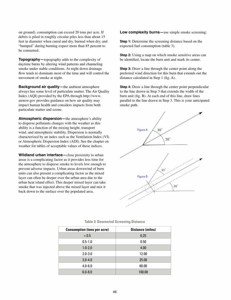
46
on ground), consumption can exceed 20 tons per acre If debris is piled in roughly circular piles less than about 15 feet in diameter when cured and dry, burned when dry, and “bumped” during burning expect more than 85 percent to be consumed
Topography—topography adds to the complexity of daytime burns by altering wind patterns and channeling smoke under stable conditions At night down drainage flow tends to dominate most of the time and will control the movement of smoke at night
Background air quality—the ambient atmosphere always has some level of particulate matter The Air Quality Index (AQI) provided by the EPA through http://www airnow gov provides guidance on how air quality may impact human health and considers impacts from both particulate matter and ozone
Atmospheric dispersion—the atmosphere’s ability to disperse pollutants changes with the weather as this ability is a function of the mixing height, transport wind, and atmospheric stability Dispersion is normally characterized by an index such as the Ventilation Index (VI) or Atmospheric Dispersion Index (ADI) See the chapter on weather for tables of acceptable values of these indices
Wildland urban interface—close proximity to urban areas is a complicating factor as it provides less time for the atmosphere to disperse smoke to levels low enough to prevent adverse impacts Urban areas downwind of burn units can also present a complicating factor as the mixed layer can often be deeper over the urban area due to the urban heat island effect This deeper mixed layer can take smoke that was injected above the mixed layer and mix it back down to the surface over the populated area
Low complexity burns—use simple smoke screening:
Step 1: Determine the screening distance based on the expected fuel consumption (table 3)
Step 2: Using a map on which smoke sensitive areas can be identified, locate the burn unit and mark its center.
Step 3: Draw a line through the center point along the preferred wind direction for this burn that extends out the distance calculated in Step 1 (fig. A).
Step 4: Draw a line through the center point perpendicular to the line drawn in Step 3 that extends the width of the burn unit (fig. B). At each end of this line, draw lines parallel to the line drawn in Step 3 This is your anticipated smoke path
Table 3: Downwind Screening Distance
Consumption (tons per acre) Distance (miles)
< 0.5 0.25
0.5-1.0 0.50
1.0-2.0 4.00
2.0-3.0 12.00
3.0-4.0 25.00
4.0-6.0 60.00
6.0-8.0 100.00
Figure A
Figure B

47
To allow for horizontal dispersion of the smoke as well as wind shifts draw two lines at 30 degree angles from the anticipated smoke path The result is the probable daytime smoke impact area Note that you will need to repeat this process if the wind direction is expected to change during the burn On many maps, one can manipulate placement of the center line intersection because of map scale or unit shape—be conservative and err on “do not burn” side
Locate all smoke sensitive targets within or immediately adjacent to the area of potential smoke impacts Smoke sensitive targets include, but are not limited to areas of existing air pollution/visibility problems, non-attainment areas, airports, communities, schools, highways, hospitals/nursing homes, Class I areas, and metropolitan areas Determine what adjustments to the prescription or mitigation steps are necessary to achieve the smoke management objectives
Clearly document any measures to be taken in dealing with smoke sensitive targets and note who is responsible for each mitigation measure
If results from the simple smoke screening appear too restrictive, try the more detailed planning approach recommended for moderate complexity burns
Moderate complexity burns—By definition moderate complexity burns are more likely to cause smoke problems than those of low complexity, and they therefore require a greater level of precision in assessing their potential impacts The Southern Forestry Smoke Management Guidebook (see Mobley and others, 1976 in Suggested Reading) presents a system for estimating particulate matter concentrations at various distances downwind of a burn. VSMOKE is a computer program that provides an alternative means of estimating smoke concentrations from a burn (Georgia Forestry Commission has implemented a web-based version of VSMOKE, http://vsmoke gfc state ga us/Vsmoke/index aspx, as has the Southern High Resolution Modeling Consortium, SHRMC, http://shrmc ggy uga edu/maps/vsmoke html)
As with the simple smoke screening for the low complexity burns, VSMOKE assumes a constant wind direction throughout the burn If weather conditions are expected to be changing throughout the course of the burn (sea breeze or approaching frontal system as examples) then a more complex smoke dispersion model such as HYSPLIT or BlueSky should be used as both of these models utilize detailed, time varying weather information to predict smoke movement in three dimensions
Examples of Mitigation Techniques
Contact people known to be sensitive to air pollution prior to the ignition of the prescribed fire if they could be impacted by smoke. This could include hospitals, nursing homes, isolated residences, etc. News releases in newspapers and by radio or TV may be appropriate. Notification to local law enforcement and government agencies prior to burning can save much time in answering citizen concerns.
Temporarily relocate affected people by providing hotel rooms for the day/night of the burn. Encourage people to close all windows and doors during the day and night of the burn to reduce their exposure to smoke.
Notify public safety agencies such as State Highway Patrol, County Sheriff, Local Law Enforcement, Highway Departments. State Forestry and Air Quality offices should also be included.
Post smoke-warning signs to warn the public of areas where smoke may create a hazard to driving. Patrol potentially affect-ed areas (especially at night and during early morning hours) to ensure residual smoke is not causing safety concerns. Be prepared to move smoke signs as needed.
Temporarily closing roads to traffic until smoke clears. Obtain assistance of appropriate jurisdictional authorities (Department of Transportation (DOT), Sheriff, State Highway Patrol) when traffic control is necessary to reduce the risk of accident from smoke on public roads.
If you anticipate a road visibility problem ask for assistance of appropriate jurisdictional authorities (Department of Trans-portation (DOT), Sheriff, State Highway Patrol) several days before planned burn day. Consider public service announcement asking people to use alternative route for a given time period. For sudden unexpected serious reductions in road visibility, call 911 and stop traffic until smoke clears. You don’t want any traffic accidents on your conscience.
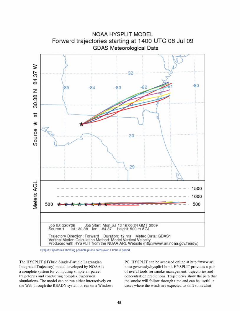
48
The HYSPLIT (HYbrid Single-Particle Lagrangian Integrated Trajectory) model developed by NOAA is a complete system for computing simple air parcel trajectories and conducting complex dispersion simulations The model can be run either interactively on the Web through the READY system or run on a Windows
PC HYSPLIT can be accessed online at http://www arl noaa gov/ready/hysplit4 html HYSPLIT provides a pair of useful tools for smoke management: trajectories and concentration predictions Trajectories show the path that the smoke will follow through time and can be useful in cases where the winds are expected to shift somewhat
Hysplit trajectories showing possible plume paths over a 12 hour period.

49
during the day While these paths do not provide information on how much smoke will reach a location, they do help in determining the potential smoke impact area The surface concentration output from HYSPLIT provides information on expected smoke concentrations every hour which can help to further refine estimates of potential smoke impact
BlueSky is not a smoke model, but rather a modeling framework that integrates a number of the tools mentioned previously in this chapter to predict cumulative impacts of smoke from forest, agricultural, and range fires across the landscape BlueSky includes tools for estimating fuel loading, fuel consumption, emissions calculation, trajectories (using HYSPLIT) and dispersion using a model known as CalPUFF Utilizing predictions from a weather forecast model and fire information, BlueSky creates forecasts of ground concentrations of smoke See http://www getbluesky org and http://www fcamms org formore information
High complexity burns—Smoke modeling for this class of burn is no different than for the moderate complexity burns presented above; the real difference comes in the level of coordination/communication required with local air quality and forestry agencies as well as the public At this level of complexity adverse smoke impacts are probable and the goal for smoke management becomes one of trying to maintain the impact as no more than a nuisance while preventing the impact from threatening public health and safety Review the prescription and determine which aspects of the prescription can possibly be altered to offer improvements for smoke management such as changing the amount and/or rate of fuel consumption, better ventilation values, or use of a firing technique more likely to loft smoke above the mixed layer such as aerial ignition
Burning at the wildland urban interface—Few WUI prescribed fire projects can pass any of the smoke screening systems currently in use, but prescribed burning is none-the-less necessary to perpetuate fire-dependent
Sample output from Bluesky showing surface PM 2.5 concentrations.

50
plant communities in the WUI and help reduce hazardous fuel accumulations For these reasons, the Southern Smoke Screening System originally described in the Southern Forestry Smoke Management Guidebook has been modified to facilitate successful smoke management when burning is conducted at the WUI The resulting system, the WUI Smoke Screening System, is largely based on extensive fieldwork conducted by Hugh Mobley, which he used to modify the original version of the Southern Forestry Smoke Management Guide. (To see the guide as modified by Mobley, go to https://fp.auburn.edu/fire/, click on “Fire Management,” then click on “Smoke Management ”) Wade and Mobley (2007) further modified the Southern Forestry Smoke Management Guide screening system for application in the WUI as part of a training course developed by the Florida Division of Forestry; the resulting WUI Smoke Screening System is a five step system intended specifically for WUI burns smaller than 50 acres and is available online at http://www treesearch fs fed us/pubs/28550
NIGHTTIME SMOKE EVALUATION
Evaluation of nighttime smoke dispersion conditions is important for any burn that is still expected to have flaming combustion one hour before sunset or when significant smoldering is expected to continue into the night Nighttime smoke dispersion conditions typically begin to develop
around one hour before sunset and continue until one hour after sunrise These conditions are normally characterized by a surface temperature inversion which acts as a lid to limit the vertical dispersion of the smoke The primary non-fire factors that need to be evaluated for nocturnal smoke dispersion are topography, winds and relative humidity
Winds at night are often weaker than during the day The inversion which acts to trap smoke near the ground also acts to decouple the surface winds from larger scale wind patterns which allows local features such as topography to play a greater role in shaping smoke dispersion conditions As the air cools, it tends to flow down drainages. The steeper the slope of the drainage, the faster these winds will be The cold air will pool in valleys at the base of the drainage Smoke will also follow this pattern, most of the time
As the wind speed at night gets stronger, the role of topography decreases This can cause smoke at night to instead move upslope/upvalley. Key factors to look at for assessing the potential for wind to alter the anticipated down drainage flow are orientation of the wind direction to the topography and the depth of the drainages/valleys The more the wind direction parallels the axis of the drainage/valley, the greater its potential influence on smoke dispersion Deeper drainages tend to be more resistant to influence from larger scale winds.
Atmospheric Dispersion Index (ADI)
RH 1 2 3-4 5-6 7-8 9-10 11-12 13-16 17-25 26-30 31-40 > 40
< 55 2 2 2 2 2 2 2 2 2 2 1 1
55-59 3 3 3 3 3 2 2 2 2 2 1 1
60-64 3 3 3 3 3 3 2 2 2 2 1 1
65-69 4 3 3 3 3 3 3 3 3 3 3 1
70-74 4 3 3 3 3 3 3 3 3 3 3 3
75-79 4 4 4 4 4 4 4 4 3 3 3 3
80-82 6 5 5 4 4 4 4 4 3 3 3 3
83-85 6 5 5 5 4 4 4 4 4 4 4 4
86-88 6 6 6 5 5 5 5 4 4 4 4 4
89-91 7 7 6 6 5 5 5 5 4 4 4 4
92-94 8 7 6 6 6 6 5 5 5 4 4 4
95-97 9 8 8 7 6 6 6 5 5 4 4 4
> 97 10 10 9 9 8 8 7 5 5 4 4 4
Table of LVORI values as a function of Atmospheric Dispersion Index and Relative Humidity. Green = Conditions with lowest proportion of accidents. White = proportion of accidents increased by a factor of 2-10 over green. Yellow = proportion of accidents increased by a factor of 10-40 over green. Orange = proportion of accidents increased by a factor of 40-150 over green.

51
Relative humidity is a complicating factor for smoke management at night Conditions that favor poor smoke dispersion, light winds and a strong temperature inversion, also favor the formation of fog when the relative humidity nears 100 percent Since the primary smoke concern at night is visibility reduction, the added possibility of another factor capable of reducing visibility increases the potential threat to public safety Further complicating the situation is the fact that combustion releases additional moisture in the air which can raise the relative humidity evens further, in rare instances resulting in supersaturation (relative humidity values that exceed 100 percent!)
The Low Visibility Occurrence Risk Index (LVORI) is designed to provide burners with an indicator for the potential for visibility related accidents to occur under a certain set of meteorological conditions (relative humidity and atmospheric dispersion index) The LVORI was develop by examining vehicle accident reports from the Florida Highway Patrol and examining the portion of these accidents that cited fog, smoke or both as a contributing factor along with the meteorological conditions This is a conservative estimator because one can smell minute concentrations of smoke, long before it can be seen The LVORI estimates the likelihood of smoke or fog being a contributing factor in an accident and is expressed on a scale of 1-10 (with 10 representing the highest likelihood of smoke/fog contributing to an accident)
Residual smoke from a daytime burn and smoke released during a nighttime burn typically flows down drainages and through gaps (such as power lines, streams and roads) However, smoke will also tend to pool in open areas such as pastures and if smoke is being produced faster than it is flowing down slope, then the smoke may find other means of escaping the area and may even move up drainage If down drainage smoke encounters dense vegetation, as it well might in a swamp or bottomland forest, it will dam up and spread across open areas even if uphill The following is a basic screening process for nighttime smoke management. Keep in mind that a screening process is designed to give you an idea of where the smoke is likely to go It is not a substitute for monitoring where your smoke is actually going
The first step is to figure out how far the smoke is likely to travel over the course of the night Use a screening distance of 10 miles for the coastal plain, 15 miles for the piedmont, or 30 miles for the mountains If surface wind speed exceeds 5 miles per hour, extend the radius an additional 5 miles in the coastal plain and piedmont and 10 miles in the mountains
If winds are over 5 miles per hour, the problem is much more complicated as the winds can overpower the drainage flows which can move smoke up drainage in some cases. Examine the relationship between the forecast wind direction and the drainages If the winds are forecast to be parallel to the drainage then the winds will either enhance or reverse the flow in the drainage. If the wind direction is perpendicular to the drainage then the wind might have little impact on the drainage flow. Deep, narrow drainages are less likely to be impacted by cross flows.
Draw a circle on a topographic map with a radius equal to the screening distance
Determine which drainages pass through or are adjacent to the burn unit. Use the topographic map to find nearby streams and drainages as well as local knowledge of forest gaps such as roads and power lines to identify where smoke is likely to move Do not neglect open areas such as pastures in which smoke can pool and possibly connect with other drainages Follow down these drainages out to the screening distance
Identify smoke sensitive features in the marked drainages
Describe in the prescribed burn plan what will be done to mitigate potential smoke impacts (especially for roads)
As an alternative to this screening process, a predictive model is available Planned Burn-Piedmont, or PB-Piedmont is a weather/smoke dispersion model specifically designed for nocturnal smoke movement. PB-Piedmont requires digital elevation data and forecast weather information as inputs Additional information on PB-Piedmont is available through the Southern High Resolution Modeling Consortium (http://www shrmc org)

52
OTHER POINTS TO CONSIDER
When using mass ignition or other techniques that favor the development of a vertical convective column, a portion of the smoke (30 percent or more typically) is likely to disperse ABOVE the mixing height where dispersion is generally poor The wind above the mixing height is often from a different direction than the transport wind
The mixing height is generally deeper over urban areas than over the forest Smoke lofted above the mixing height while not impacting rural areas is likely to mix back down to the ground over urban areas
Plumes from multiple prescribed fires can merge and cause a much larger air quality impact than one might expect Thus the prudent burner will ask the agency issuing the burn permit/authorization if any other units over about 750 acres in size have received a go-ahead on that day If the answer is yes, one should spend some time ruminating over the information including the distance and direction from his/her planned burn before deciding whether to proceed or postpone the burn It is often worthwhile to call the other burner and discuss the situation as you might be able to stagger the timing of the burns if using aerial ignition, or one or both of you might be willing to burn less acreage that day
Avoid igniting organic soils as they are difficult to suppress and can smolder for long periods of time, creating significant residual smoke problems A good rule of thumb is not to burn such areas when the water table is below the surface
Verify that the smoke is behaving as expected Document smoke behavior with photographs when possible, particularly in cases where smoke may impact a road
If smoke sensitive targets are likely to be adversely impacted, explore possible mitigation strategies Managing emissions revolves around manipulating the amount of fuel consumed This can be accomplished by burning a smaller area, burning under higher moisture conditions, or applying a preburn herbicide or mechanical treatment
Have a contingency plan if things go wrong If smoke begins reducing visibility on a roadway know who to call and be prepared to take whatever steps necessary to minimize the threat—road closure, posting signs, traffic control, suppressing the fire if needed.
When nighttime residual smoke is expected within a mile or so of an urban area or paved road, or when it is obvious that there is considerable smoldering after the flame front passes, begin mopup ASAP and continue until dark, then patrol throughout the night Be advised that visibility can deteriorate from clear to less than a few feet in less than 10 minutes at night so constantly patrol nearby paved roads
Sample output from PB-Piedmont showing smoke (yellow particles) moving down drainages and crossing roads at points A, B, and C.

53
EXECUTING A SMOKE MANAGEMENT PLAN
Obtain and use fire weather forecasts—Fire weather forecasts contain information that is not commonly part of the general forecast provided in the radio/TV forecast Smoke management information such as mixing height, transport winds, ventilation index and/or dispersion index should be part of the forecast you use Don’t rely on yesterday’s forecast, get an updated one the day of the burn Do not routinely ask for a spot-weather forecast as they require significant effort to produce, but don’t hesitate to ask for one when you believe it is necessary for a successful burn
Don’t burn during pollution alerts or stagnation conditions—Do not add to the problem Such conditions are often reported in the discussion section of the fire weather forecast
Comply with all air pollution control regulations—Know the rules that apply at the proposed burn site. Check with the State fire control agency if unsure.
Notify your local fire control office, nearby residents and adjacent land owners—This is common courtesy and can go a long way in reducing complaints, in addition it is required in most areas People need to know that your fire is not a wildfire.
Use test fires to confirm behavior of both the fire and its smoke—Test fires are often used to make certain that the fire behavior is within acceptable limits. Use these fires to make sure the smoke is doing what you expect which means a two minute 100 square foot fire is not acceptable. The test fire should ideally be located within the burn unit, but if not, in similar fuels
Consider backing fires when smoke is an issue—Backing fires consume dead fuels more completely and produce less smoke. However, backing fires are not always the answer
l Backing fires are slow, which is a concern as this spreads the smoke out over a longer period thus making prediction more difficult as the weather is more likely to change (particularly the mixing height) Using a backing fire may require you to start your burn earlier, before the mixing height attains its predicted early afternoon value, thereby restricting combustion products to a shallower layer A backing fire may also cause the burn to continue late into the afternoon when mixing heights will drop and trap smoke near the surface
l Backing fires are lower intensity and therefore do not develop as strong of a convection column The weak convection column limits smoke plume rise which keeps all of the smoke within the mixed layer Other burning techniques can be used to produce more heat and loft smoke over nearby smoke sensitive targets
Try to burn during the middle of the day and be done well before sunset—Dispersion conditions are generally best at this time
Mopup along roads—Start mopup along roads as soon as possible to reduce any impact on visibility Extinguish all stumps, snags and logs Be particularly aggressive when roads are in or near drainages that may channel smoke at night
Monitor your smoke—Patrol the burn perimeter after burn and document where the smoke is/is not going
Have an emergency plan—Be prepared to extinguish the fire if the weather, fire behavior or smoke conditions are not within the ranges specified in the burn plan. Have warning signs available Have contact information for local law enforcement
Keep in mind that this is your fire, and the smoke is your problem.


55
Planning the Prescribed BurnThe first step to a successful prescribed burn is a stand by stand analysis of your forest lands Determine the needs of each stand and what actions should be taken to meet these needs. Prescribed fire as well as other alternatives should be addressed here and a decision reached regarding the preferred treatment
Prescription burning is a highly technical job requiring knowledge of fire behavior, suppression techniques and environmental effects of fire. Well in advance of the burning season, scout stands that may need a fire treatment and choose those to burn The number of suitable burning days varies widely from year to year Aerial ignition can be used to maximize the number of acres burned on each suitable burn day Set priorities if you have several blocks to burn. Specifically designate any planned burns that require exacting weather conditions Considerations include heavy fuels, small trees, potential smoke problems etc Indicate all blocks to be burned on an administrative map When the burns are completed, record the dates on the map
A written prescribed burn plan prepared by a knowledgeable person is needed for each area to be burned Complete the plan before the burning season and be prepared to burn when the prescribed weather conditions occur Some of the plans may be quite short and simple while others will be long and complex Individual blocks can vary from a few acres to over a thousand, but topography and amount/type of fuel should be similar in a unit Your plan can consist of a series of blocks in the same compartment or management unit as long as the same objectives apply and the fuel is similar
THE WRITTEN PLAN
A prepared form with space for all needed information is best The form will serve as a checklist to be sure you have not overlooked some aspect or potential impact Sample forms for both understory burns and post-harvest burns can be found at the end of this chapter Contents of the written plan should include:
Required signatures—Provide spaces for signature(s) of person(s) who prepared the plan. This identifies the people who know the most about the plan
Purpose and objectives—Include in the written plan the reason for prescribing fire as a treatment for this piece of land Examples include: prepare seedbed, control insects
or disease, reduce hazardous fuels, improve wildlife habitat, control understory, improve forage, increase accessibility and enhance aesthetics In addition, include one or more specific, quantifiable objectives. State exactly what the fire will do—what it should kill or consume, how much litter/duff should be left, etc Also, concisely describe the expected fire behavior, including desired range of flame lengths and fireline intensities. In case prescribed weather conditions do not materialize, this description may allow the objective(s) to still be achieved by varying the firing technique This information will also be useful in evaluating the success of a burn
Map of the burning unit—A detailed map of each burn unit is an important part of the burn plan The map should show the boundaries of the planned burn, adjacent land owners, topography, control lines (both existing and those needing construction), anticipated direction of the smoke plume, smoke-sensitive features, holding details and other essential information Plowed control lines are often not necessary Consider expanding the planned burn to employ existing fire breaks and natural barriers. For example, use fuel type boundaries such as occur near creek bottoms where the fire will go out as it encounters fuels with higher moisture content Show areas that should be excluded or protected such as improvements, young reproduction, threatened and endangered species, etc Subdivide areas into logical, 1-day burning blocks or smaller areas if smoke management dictates
Burning unit map

56
Equipment and personnel—List equipment and personnel needed onsite and on standby with assigned duties
Fire prescription—The amount of fuel, weather conditions and desired intensity of the burn will determine the firing technique and ignition pattern to use to meet the burn’s objectives Species involved and height of overstory will determine the maximum intensity that can be tolerated Where large amounts of fuel are present, cooler burns can be accomplished by burning when humidity and fuel moisture are near the high end of the range so a smaller fraction of the fuel will be consumed Lower temperatures are desirable with more intense fires, especially when understory fuels are tall, to limit the potential for crown scorch
Behave-plus (http://www.firemodels.org/content/view/30/39/) is a useful program for predicting fire behavior values to include in a burn plan The calculations are based on data about fuels, weather, and topography Important to look at potential fire behavior in the burn unit and in surrounding areas to aid in contingency planning for a possible escaped fire.
Season—Most understory burning is done during the winter dormant season when acceptable fuel/weather conditions are most frequent Good for high fuel loads Weather and fuel conditions are more variable and often fire danger is higher, particularly in late spring Also must consider potential impact on nesting wildlife Vegetation can be more susceptible to heat damage (pine buds) Hot weather during the summer means that less heat is required to raise the temperature of plant tissue to lethal levels For this reason summer burns are often used to kill undesirable hardwoods Care must be taken to avoid damaging overstory crowns Late summer is a good time for post-harvest burns as the high temperatures help dry out the larger material Exercise care when burning in early fall just prior to the dormant season Both loblolly and slash pine are more likely to die if severely scorched or root damaged at this time
Time of day—Normally, plan prescribed burn operation so that the entire job can be completed within a standard workday. Prescribed fires are typically ignited between 10 a m and noon, after any morning dew has had a chance to evaporate and any surface inversion from the previous night has lifted If the forecast is for poor nighttime dispersion, halt ground ignition before 3 p m Halt aerial ignition before 4 p.m. to allow adequate time for the fire to burn out before atmospheric dispersion conditions deteriorate
Burning conditions are usually better during the day than at night because wind speeds are higher, wind directions are more steady, and an unstable atmosphere favors the vertical dispersion of smoke These conditions make smoke management much easier during the day At night smoke tends to stay near the ground and collects in depressions Also, relative humidity is higher at night, resulting in spotty burning and an increased likelihood of fog formation
However, on some winter nights when a strong cold front is moving through the area, winds remain strong and persistent and relative humidity does not rise greatly These conditions can provide good prescribed burning conditions especially when cooler temperatures are needed Whenever night burning is done, keep a close watch on the weather and smoke drift
Firing plan—Key parts for a successful prescribed burn are plans for firing and holding the burn. This plan should consist of a narrative section and a detailed map (the burn unit map is ideal for this) Important information to include:
l Firing technique, ignition pattern and planned ignition time
l Manpower and equipment needed and planned distribution for setting, holding, patrolling and mopping up the fire and managing the smoke.
l Location and number of reinforcements and equipment that can be mobilized rapidly in the event that the fire escapes Also include location of water sources
l Instructions for all supervisory personnel, including complete description or illustration of assignment, and forces needed to fire, hold and mop up the fire.
Alternative prescription—Consider alternative sets of weather and fuel conditions, along with firing techniques that will produce a fire of roughly the same intensity and accomplish the desired objectives Sometimes this alternative may require two separate burns when dealing with heavy fuel loads
Preparation work and protection of sensitive features—Include the fire lines to be constructed, snags to be lined or felled, special features to be protected and the installation of any monitoring equipment Give instructions for the protection of sensitive areas Consider historical and archaeological sites, streams, habitats of threatened and endangered species, and fragile soils

57
Notification of intent to burn—List the names and telephone numbers of the local State fire protection officer and other officials who should be contacted prior to the burn Make direct contact with all homes and businesses in the area likely to be impacted by the burn Consider written notification explaining the reasons for the burn and encouraging those with respiratory problems to contact you – include a telephone number for them to use Offer to evacuate anyone with respiratory problems during the burn (consider putting them up in a hotel if necessary) Establish responsibility for burn-day contacts and how they will be made Consider a newspaper article describing the reasons for the burn if you expect to produce lots of smoke and anticipate negative reactions
Impact of smoke—List any sensitive areas near to, downwind, or down drainage of the burn unit Include smoke management strategies (avoidance, emissions reduction, dispersal) used to minimize adverse impacts at these sites Attach the smoke management plan (e g screening system calculations) as part of the burn plan
Legal requirements—List any legal requirements that might apply and what the prescribed burner must do to comply Remember, the person conducting the prescribed burn may not be the one who conducted the analysis and wrote the prescription Follow all applicable statutes, regulations and agency procedures The need for a written prescribed burning plan, documentation of deviations from the plan, and good judgment cannot be overemphasized Erroneous forecasts, unforeseen local influences, and accidents occur despite our best efforts to prevent them Proper documentation will help establish that the prescribed fire was conducted in a prudent and professional manner. If a prescribed fire results in damage or bodily harm and you cut corners, neglected any mandatory requirements, or acted with disregard to the welfare of others, you are likely to be held responsible, regardless of whether compliance would have changed the outcome For more information see the summary article, Legal Implications of Prescribed Burning in the South by William C Seigal, listed in the Suggested Reading section
Escaped fire plan—Identify potential fire escapes and specify actions to take in the event such an escape occurs Designate who will be in charge of suppression action and what personnel and equipment will be available Using Behave-plus to estimate potential fire behavior in areas adjacent to the burn unit can help in determining suppression needs
Control and mop up—The plan must include necessary safeguards to confine the fire to the prescribed area and reduce smoke impact Mop up promptly and completely when practical Consider and make plans for any variation in forecasted weather that may change a prescribed fire into a damaging wildfire, increase the pollution in smoke-sensitive areas, or create a visibility problem on adjacent roads
Evaluation—Include space for a written evaluation of the prescribed burn A record of actual and forecasted weather conditions, fire behavior, and total environmental effects of the burn is essential This information is used to determine if the objectives of the burn were achieved and can help in planning future burns
At the beginning of the prescribed burn, record the forecasted weather and current conditions (wind speed and direction, temperature, relative humidity, fuel moisture, days since and amount of last rain and the dampness of the litter and duff) Documenting that weather conditions are within the acceptable ranges specified in the prescription is critical to supporting ones decision to burn. Also, fire behavior information such as the firing technique, flame length and forward rate of spread should be recorded to document that the fire behavior matches expectations. Continue to record this weather and fire information periodically throughout the burn After the burn record the amount of crown scorch, consumption of brush, litter and duff, and any evidence of fire intensity such as unburned areas, exposed mineral soil, and cracks in bark or cupping on the lower bole due to bark consumption Also include a short narrative on the success of the burn

58
Simple Understory Prescribed Burning Unit Plan Landowner Permit no.
Address Phone no.
S T R County Acres to burn Previous burn date
Purpose of burn
(Draw map on back or attach)
Stand Description
Overstory type & Size Height to bottom of crown
Understory type & height
Dead fuels: description and amount
Preburn Factors
Manpower & equipment needs
List smoke-sensitive areas & locate on map
Special precautions
Estimated no. hours to complete Passed smoke screening system
Adjacent landowners to notify
Weather Factors: Desired Range Predicted Actual
Surface winds (speed & dir.) _______________________ ____________________________
Transport winds (speed & dir.) _______________________ ____________________________
Minimum mixing height _______________________ ____________________________
Dispersion/stagnation index _______________________ ____________________________
Minimum relative humidity _______________________ ____________________________
Maximum temperature _______________________ ____________________________
Fine-fuel moisture (%) _______________________ ____________________________
Days since rain Amount _______________________ ____________________________
Fire Behavior: Desired Range Actual
Type fire
Best month to burn Date burned
Flame length
Rate of spread
Inches of litter to leave
Evaluation: Immediate Future
Any escapes? Acreage Evaluation by
Objective met Date
Smoke problems Insect/disease dam.
% of area with crown discoloration of Crop Tree Mortality
5-25% 26-50% 51-75% 76%+ % understory kill
Live crown consumption Soil movement
% understory veg. consumed Other adverse effects
Adverse publicity
Technique used OK Remarks
Remarks
Prescription made by
Title Date / /
SIMPLE UNDERSTORY PRESCRIBED BURNING UNIT PLAN
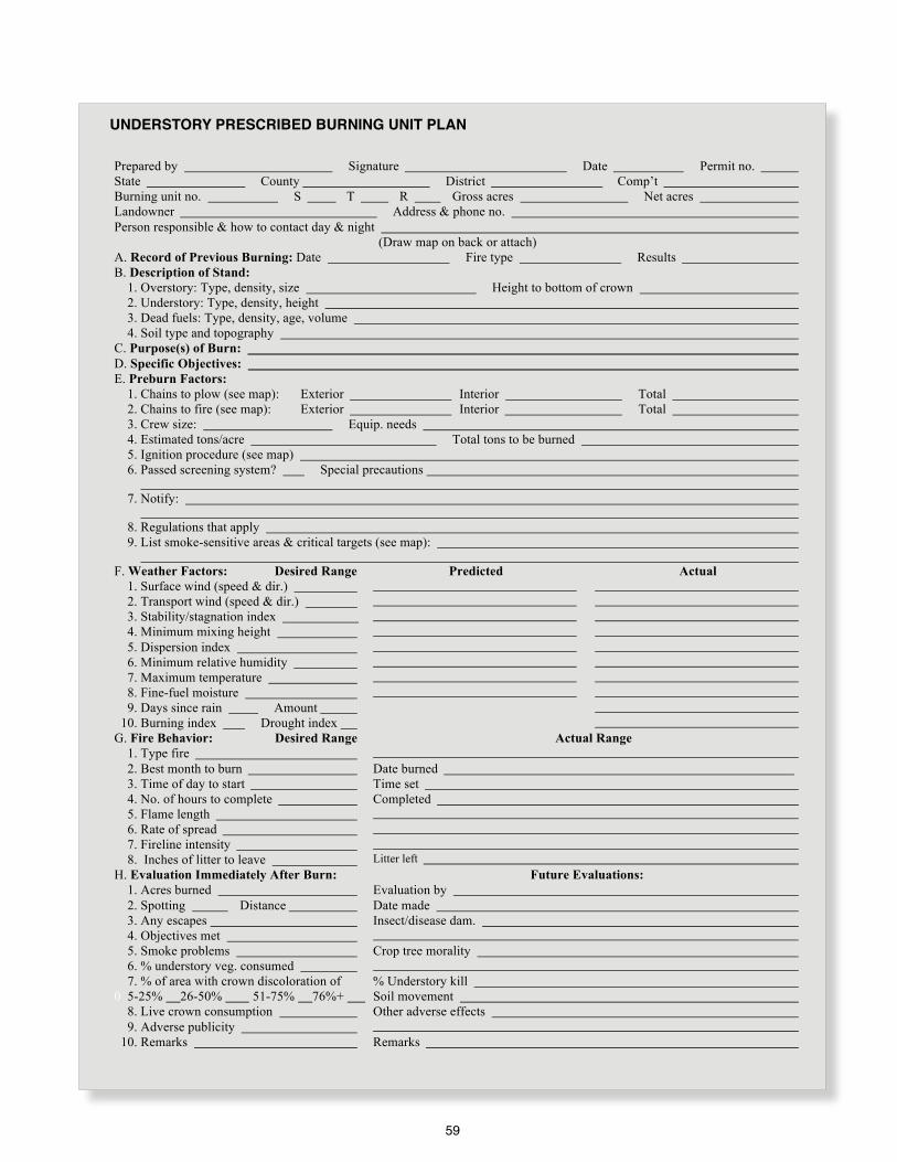
59
Understory Prescribed Burning Unit Plan
Prepared by Signature Date Permit no.
State County District Comp’t
Burning unit no. S T R Gross acres Net acres
Landowner Address & phone no.
Person responsible & how to contact day & night
(Draw map on back or attach)
A. Record of Previous Burning: Date Fire type Results
B. Description of Stand:
1. Overstory: Type, density, size Height to bottom of crown
2. Understory: Type, density, height
3. Dead fuels: Type, density, age, volume
4. Soil type and topography
C. Purpose(s) of Burn:
D. Specific Objectives:
E. Preburn Factors:
1. Chains to plow (see map): Exterior Interior Total
2. Chains to fire (see map): Exterior Interior Total
3. Crew size: Equip. needs
4. Estimated tons/acre Total tons to be burned
5. Ignition procedure (see map)
6. Passed screening system? Special precautions
7. Notify:
8. Regulations that apply
9. List smoke-sensitive areas & critical targets (see map):
F. Weather Factors: Desired Range Predicted Actual
1. Surface wind (speed & dir.)
2. Transport wind (speed & dir.)
3. Stability/stagnation index
4. Minimum mixing height
5. Dispersion index
6. Minimum relative humidity
7. Maximum temperature
8. Fine-fuel moisture
9. Days since rain Amount
10. Burning index Drought index
G. Fire Behavior: Desired Range Actual Range
1. Type fire
2. Best month to burn Date burned
3. Time of day to start Time set
4. No. of hours to complete Completed
5. Flame length
6. Rate of spread
7. Fireline intensity
8. Inches of litter to leave Litter left
H. Evaluation Immediately After Burn: Future Evaluations:
1. Acres burned Evaluation by
2. Spotting Distance Date made
3. Any escapes Insect/disease dam.
4. Objectives met
5. Smoke problems Crop tree morality
6. % understory veg. consumed
7. % of area with crown discoloration of % Understory kill
0 5-25% 26-50% 51-75% 76%+ Soil movement
8. Live crown consumption Other adverse effects
9. Adverse publicity
10. Remarks Remarks
UNDERSTORY PRESCRIBED BURNING UNIT PLAN
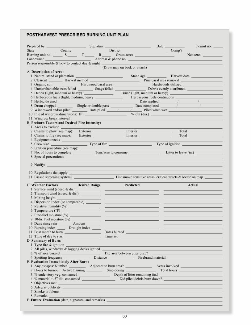
60
Postharvest Prescribed Burning Unit Plan
Prepared by Signature Date Permit no.
State County District Comp’t
Burning unit no. S T R Gross acres Net acres
Landowner Address & phone no.
Person responsible & how to contact day & night
(Draw map on back or attach)
A. Description of Area:
1. Natural stand or plantation Stand age Harvest date
2. Clearcut Harvest method Pine basal area removal
3. Organic soil Hardwood basal area Hardwoods utilized
4. Unmerchantable trees felled Snags felled Debris evenly distributed
5. Debris (light, medium or heavy) Brush (light, medium or heavy)
6. Herbaceous fuels (light, medium, heavy Herbaceous fuels continuous
7. Herbicide used Date applied / /
8. Drum chopped Single or double pass Date completed / /
9. Windrowed and/or piled Date piled / / Piled when wet
10. Pile of windrow dimensions: Ht. Width (dia.)
11. Windrow break interval
B. Preburn Factors and Desired Fire Intensity:
1. Areas to exclude
2. Chains to plow (see map): Exterior Interior Total
3. Chains to fire (see map): Exterior Interior Total
4. Equipment needs
5. Crew size Type of fire Type of ignition
6. Ignition procedure (see map):
7. No. of hours to complete Tons/acre to consume Litter to leave (in.)
8. Special precautions:
9. Notify:
10. Regulations that apply
11. Passed screening system? List smoke sensitive areas, critical targets & locate on map
C. Weather Factors Desired Range Predicted Actual
1. Surface wind (speed & dir.)
2. Transport wind (speed & dir.)
3. Mixing height
4. Dispersion Index (or comparable)
5. Relative humidity (%)
6. Temperature (°F)
7. Fine-fuel moisture (%)
8. 10-hr. fuel moisture (%)
9. Days since rain Amount
10. Burning index Drought index
11. Best month to burn Dates burned
12. Time of day to start Time set
D. Summary of Burn:
1. Type fire & ignition
2. All piles, windrows & logging decks ignited
3. % of area burned Did area between piles burn?
4. Spotting frequency Distance Firebrand material
E. Evaluation Immediately After Burn:
1. Any escapes: Number Adjacent to burn area? Acres involved
2. Hours to burnout: Active flaming Smoldering Total hours
3. % understory veg. consumed Depth of litter remaining (in.)
4. % material < 3” dia. consumed Did piled debris burn down?
5. Objectives met
6. Adverse publicity
7. Smoke problems
8. Remarks
F. Future Evaluation (date, signature, and remarks)
POSTHARVEST PRESCRIBED BURNING UNIT PLAN

61
Preparing for the Prescribed BurnGood preparation and a clear objective are the keys to successful burning and are essential in realizing maximum net benefits at acceptable costs. Preparation consists of all activities necessary to make an area ready for firing and having all needed tools equipment and information ready to go Much of this work is conducted by the burn boss To do this job skillfully, the burn boss should have personal knowledge or information available about:
l Weather elements involvedl Fire behaviorl Smoke managementl Amount and type of fuel on the areal Location of natural and man-made fire barriersl Degree of risk and hazard presentl Burning technique and intensity of fire to be usedl Burning objectives for the particular areal Restrictive measures dictated by law or local customl Fire suppression safetyl Location of any improvements which could be
endangeredl Areas within the prescribed unit that may need to be
excluded from fire such as: areas with extreme mop up or breakover potential (sawdust piles, muck soils, snags, etc ) highly scenic areas highly erodible areas areas harboring special-quality wildlife or plant communities that would be damaged by fire desirable hardwood areas timber and grass areas susceptible to fire damage
All site-specific information should be included in the written prescription Before starting work, the burn boss should inspect the area by walking over it and should give safety instruction to all work crews
ESTABLISHING CONTROL LINES
l Construct lines in advance of burning, preferably after leaf fall to reduce effect of fallen material on prepared lines Control lines should reach mineral soil and can be constructed by plowing, disking, tilling or raking
l Use existing barriers such as streams, logging roads, or cultivated fields whenever possible.
l Hold plow lines to a minimum, keeping them shallow and on the contour as much as possible in hilly terrain Consider igniting from wet lines Use skid trails and logging roads where feasible
l Keep control lines as straight as possible. Bend them around excluded areas, avoiding abrupt changes in direction
l Avoid rock outcrops and boggy ground l Double or widen control lines in hazardous places l Subdivide large areas into logical 1-day burning jobs l Avoid leaving dense timber stands or heavy fuel pockets
near lines l Mow problem fuel spots near control lines to reduce
potential spotovers
AFTER CONTROL LINES ARE ESTABLISHED
l Remove any material above the line that could carry fire across the control line such as vines and overhanging brush
l Fall snags near line (inside and outside) – this should be done judiciously and in consideration of the value to wildlife of the snag
l Construct water bars and leadoff ditches in steeper terrain to prevent soil erosion
l Seed and fertilize exposed soil with native or non-invasive species on control lines in steep topography to prevent soil erosion
BURN UNIT MAP
l Locate all control lines on the map noting changes from the original plan
l Note on the map any danger spots along control lines having potential for fire escape.

62
Eddies caused by forest openings.
Convections and eddies for open areas.
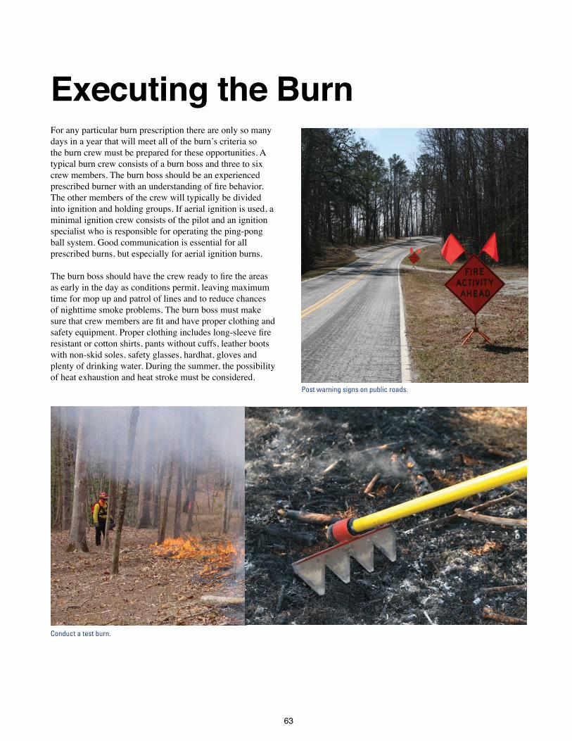
63
Executing the Burn For any particular burn prescription there are only so many days in a year that will meet all of the burn’s criteria so the burn crew must be prepared for these opportunities A typical burn crew consists of a burn boss and three to six crew members The burn boss should be an experienced prescribed burner with an understanding of fire behavior. The other members of the crew will typically be divided into ignition and holding groups If aerial ignition is used, a minimal ignition crew consists of the pilot and an ignition specialist who is responsible for operating the ping-pong ball system Good communication is essential for all prescribed burns, but especially for aerial ignition burns
The burn boss should have the crew ready to fire the areas as early in the day as conditions permit, leaving maximum time for mop up and patrol of lines and to reduce chances of nighttime smoke problems The burn boss must make sure that crew members are fit and have proper clothing and safety equipment. Proper clothing includes long-sleeve fire resistant or cotton shirts, pants without cuffs, leather boots with non-skid soles, safety glasses, hardhat, gloves and plenty of drinking water During the summer, the possibility of heat exhaustion and heat stroke must be considered
Post warning signs on public roads.
Conduct a test burn.

64
CHECKLIST
Make sure all equipment is in working order and that it is safe to use
Carry burn plans and maps to the site
Have a means of instant communication with all crew members. Portable radios are very useful as are cellphones, but make sure that all sections of the burn unit have good reception.
Check the weather before starting to burn and keep updated throughout the day
Check all control lines, clean out needles and leaves and reinforce if necessary
Notify adjoining property owners and local fire control organizations before starting fire
Instruct crew on procedures, including safety precautions and the proper operation of equipment and use of hand tools
Inform the crew of starting point and firing plan. Give each member a map.
Post signs on public roads and be prepared to control traffic if potential exists for smoke to reduce visibility
Check duff and soil for dampness
Test burn with a small fire before firing off the unit; check fire and smoke behavior and make sure they match expectations. If not, decide whether the observed fire /smoke behavior are acceptable. This is the time to cancel the burn if you are not comfortable with the observed behavior. Note on the plan the results of the test burn and your decision to burn or not.
Be alert to changing conditions and be prepared to change burning techniques or plow the fire out if an emergency arises
Burn so the wind will carry the smoke away from sensitive targets
Mop up and patrol perimeters constantly during the operation and thereafter until there is no further danger of fire escape or smoke problems.

65
Evaluating the BurnBurn evaluations are an important means for determining how well the stated objectives of the burn were met as well as gaining information to be used in future burns An initial evaluation should be made immediately after the burn, perhaps the following morning A second evaluation should be made during or after the first postfire growing season.
GENERAL POINTS TO BE CONSIDERED
l Was preburn preparation properly done and adequate for the burn?
l Were objectives met?l Was the burn plan followed? Were changes made and
documented?l Were weather conditions, fuel conditions, fire behavior
and smoke dispersion within planned limits? Were any deviations documented?
l What were the effects on soil, air, vegetation, water and wildlife?
l Was the fire confined to the intended area; any escapes?l Was the burning technique correct?l Were costs commensurate with benefits derived?l What could be done to improve similar burns next time?
POINTS IN FIRST EVALUATION
l Amount of overstory foliage discolorationl Amount of consumption and top-kill of understory
vegetationl Amount of litter/duff remaining on forest floorl Amount of mineral soil exposedl Impacts to non-target speciesl Degree of success in avoiding smoke-sensitive featuresl Protection of areas not to be burned; any escapes?l Any adverse public comment or reaction prior to, during
or immediately after the burn
POINTS FOR SECOND EVALUATION
l Resin exuding from pine trees, an indicator of cambrium damage or insect attack
l Signs of disease or insect damagel Mortality of timber or other desirable vegetationl Sprouting vigor of undesired vegetationl Remaining duff layer, mineral soil exposed, and any soil
movementl Public expression for or against the burning programl Ground cover responsel Invasive speciesl Impacts to target species
INDICATIONS AND GUIDELINES
Needle scorch—The best indicator of crop tree damage is percent of foliage discoloration Assuming that buds and branchlets are not heat-killed, even crown scorch approaching 100 percent generally will not kill trees unless secondary factors such as insect attacks, disease or drought materialize However, loblolly pine stands burned in the fall after their last needle flush prior to dormancy, are likely to be killed by 100 percent crown scorch Slash pine appears to be more tolerant of severe crown scorch during the fall
If more than 15 percent of a southern pine tree’s needles are actually consumed by flames, the tree’s chances of survival would be poor even if very little of the rest of the crown is scorched Young vigorous trees are more likely to survive severe crown damage than are older individuals
Magnitude and duration of growth responses in southern pines due to various levels and seasons of defoliation are not well documented Both negative and positive responses have been observed, but the preponderance of
Percent Crown Scorch Damage
0 to 33 Some volume growth loss may occur the first postfire growingseason but it will be minor.
34 to 66 Volume growth loss usually less than 40 percent and confined to the first postfire growing season.
67 to 100 Reduction may be as high as a full year’s vol-ume growth spread over 3 years.

66
evidence shows a direct relationship between diameter and height growth loss and crown scorch Providing no crown consumption occurs, the following table will help estimate potential growth loss in loblolly and slash pines over 3 inches dbh These “ball park” estimates can be used for other southern pines as well, until more specific results become available
A good indicator of hardwood control is a series of bark cracks extending into the cambrium near ground level This indicates sufficient heat was applied to penetrate the bark and kill the cambrium Although large hardwoods can be damaged by periodic fires, they are hard to kill.
Judge the success of burning for brownspot control by the number of longleaf seedlings with all infected needles burned off, but still having a protective sheath of green needles around an unharmed terminal bud
Soil and root damage—Burning under prescribed conditions in the South generally does not expose much bare soil If duff remains after a burn, the physical properties of the soil were probably not harmed If mineral soil is exposed, especially on steep slopes, soil movement and deterioration of site quality may occur
Root damage is likely whenever the organic layer is completely consumed It should also be expected whenever burns are conducted over dry soils (drought conditions) or when a deep litter layer is present New root growth in vigorously growing pines can usually offset
losses, but older trees, having survived such fires without crown damage, often die six months to a year later for no apparent reason
Air quality—Smoke behavior must be continually monitored from the time the fire is ignited until smoldering ceases Unusual or unexpected smoke plume behavior should be noted and correlated with other parameters of the burn for future reference Any public complaints should be recorded as part of the evaluation
Post-burn evaluation helps to determine if the objectives of the fire were met.
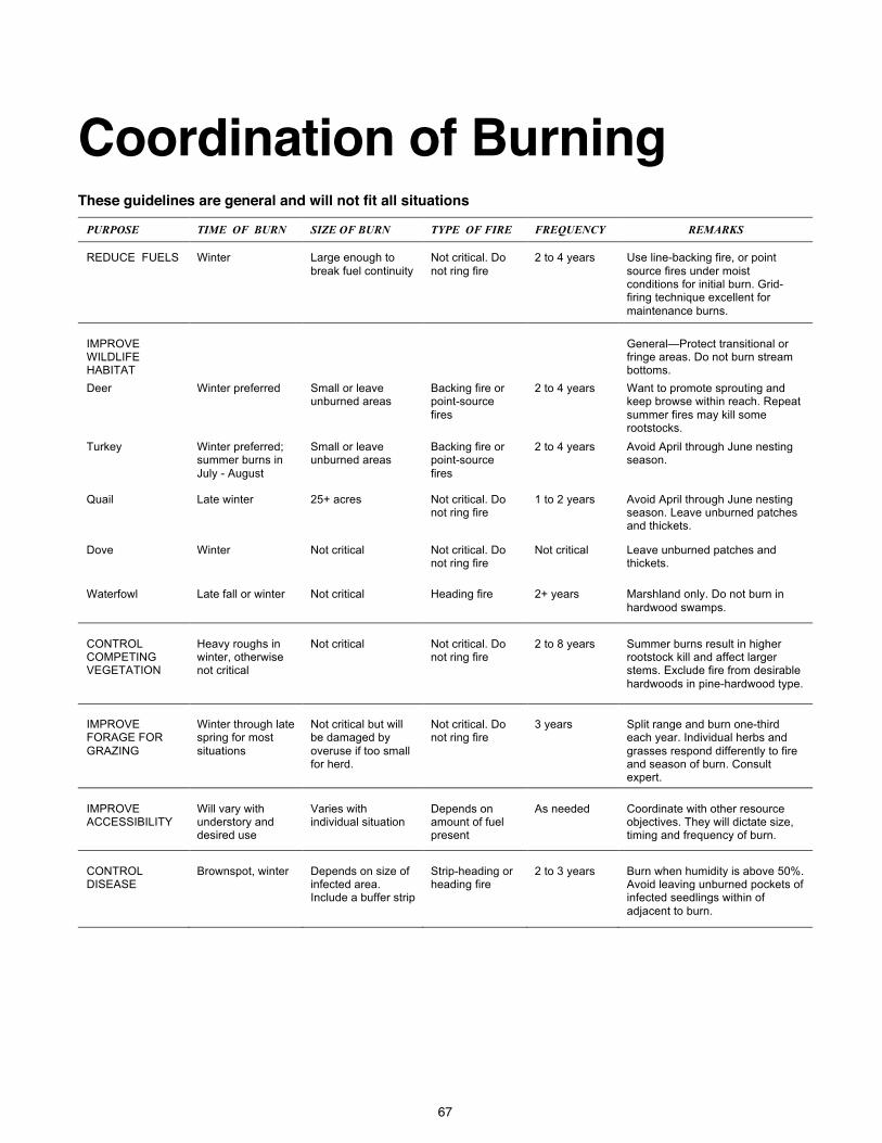
67
Coordination of BurningThese guidelines are general and will not fit all situations
PURPOSE TIME OF BURN SIZE OF BURN TYPE OF FIRE FREQUENCY REMARKS
REDUCE FUELS Winter Large enough to
break fuel continuity
Not critical. Do
not ring fire
2 to 4 years Use line-backing fire, or point
source fires under moist conditions for initial burn. Grid-firing technique excellent for
maintenance burns.
IMPROVE WILDLIFE HABITAT
General—Protect transitional or fringe areas. Do not burn stream bottoms.
Deer Winter preferred Small or leave unburned areas
Backing fire or point-source
fires
2 to 4 years Want to promote sprouting and keep browse within reach. Repeat
summer fires may kill some rootstocks.
Turkey Winter preferred; summer burns in
July - August
Small or leave unburned areas
Backing fire or point-source
fires
2 to 4 years Avoid April through June nesting season.
Quail Late winter 25+ acres Not critical. Do not ring fire
1 to 2 years Avoid April through June nesting season. Leave unburned patches and thickets.
Dove Winter Not critical Not critical. Do not ring fire
Not critical Leave unburned patches and thickets.
Waterfowl Late fall or winter Not critical Heading fire 2+ years Marshland only. Do not burn in
hardwood swamps.
CONTROL COMPETING VEGETATION
Heavy roughs in winter, otherwise not critical
Not critical
Not critical. Do not ring fire
2 to 8 years
Summer burns result in higher rootstock kill and affect larger stems. Exclude fire from desirable
hardwoods in pine-hardwood type.
IMPROVE FORAGE FOR
GRAZING
Winter through late spring for most
situations
Not critical but will be damaged by
overuse if too small for herd.
Not critical. Do not ring fire
3 years
Split range and burn one-third each year. Individual herbs and
grasses respond differently to fire and season of burn. Consult expert.
IMPROVE ACCESSIBILITY
Will vary with understory and desired use
Varies with individual situation
Depends on amount of fuel present
As needed
Coordinate with other resource objectives. They will dictate size, timing and frequency of burn.
CONTROL DISEASE
Brownspot, winter
Depends on size of infected area. Include a buffer strip
Strip-heading or heading fire
2 to 3 years
Burn when humidity is above 50%. Avoid leaving unburned pockets of infected seedlings within of
adjacent to burn.
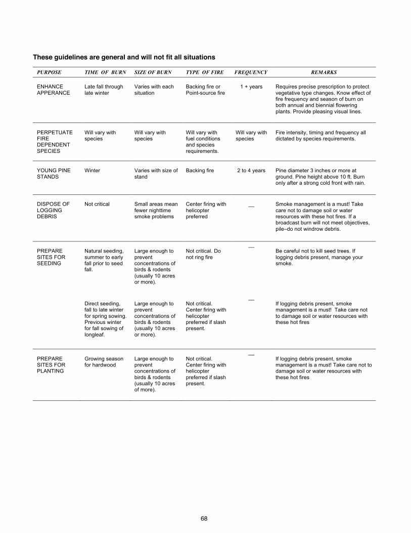
68
These guidelines are general and will not fit all situations
PURPOSE TIME OF BURN SIZE OF BURN TYPE OF FIRE FREQUENCY REMARKS
ENHANCE
APPERANCE
Late fall through
late winter
Varies with each
situation
Backing fire or
Point-source fire
1 + years
Requires precise prescription to protect
vegetative type changes. Know effect of fire frequency and season of burn on both annual and biennial flowering
plants. Provide pleasing visual lines.
PERPETUATE FIRE DEPENDENT
SPECIES
Will vary with species
Will vary with species
Will vary with fuel conditions and species
requirements.
Will vary with species
Fire intensity, timing and frequency all dictated by species requirements.
YOUNG PINE
STANDS
Winter
Varies with size of
stand
Backing fire
2 to 4 years
Pine diameter 3 inches or more at
ground. Pine height above 10 ft. Burn only after a strong cold front with rain.
DISPOSE OF
LOGGING DEBRIS
Not critical
Small areas mean
fewer nighttime smoke problems
Center firing with
helicopter preferred
__
Smoke management is a must! Take
care not to damage soil or water resources with these hot fires. If a broadcast burn will not meet objectives,
pile–do not windrow debris.
PREPARE
SITES FOR SEEDING
Natural seeding,
summer to early fall prior to seed fall.
Large enough to
prevent concentrations of birds & rodents
(usually 10 acres or more).
Not critical. Do
not ring fire
__ Be careful not to kill seed trees. If
logging debris present, manage your smoke.
Direct seeding, fall to late winter
for spring sowing. Previous winter for fall sowing of
longleaf.
Large enough to prevent
concentrations of birds & rodents (usually 10 acres
or more).
Not critical. Center firing with
helicopter preferred if slash present.
__ If logging debris present, smoke management is a must! Take care not
to damage soil or water resources with these hot fires
PREPARE SITES FOR PLANTING
Growing season for hardwood
Large enough to prevent concentrations of
birds & rodents (usually 10 acres of more).
Not critical. Center firing with helicopter
preferred if slash present.
__
If logging debris present, smoke management is a must! Take care not to damage soil or water resources with
these hot fires

69
General Rules 1. Observe and follow all local laws and guidelines
2. Obtain and use latest weather and smoke management forecasts
3. Relative humidity will roughly halve with each 20° F increase in temperature in a given air mass
4. Expect increased spotting when relative humidity drops below 30 percent
5. Burn when mixing height is above 1,650 feet (500 m)
6. Do not burn under temperature inversions
7. Never underburn during a drought Soil moisture is needed to protect tree roots and lower litter
8. Don’t burn on organic soils unless the water table is very close to the surface
9. Heading fires produce about three times more particulate than backing fires.
10. Burn when fuels are dry, but not too dry Wet fuels produce substantially more particulate than do dry fuels
11. Start burning logging debris by midmorning
12. Site prep burning behind chopping or other mechanical treatment gives best results if done 10 to 15 days after treatment
31. Windrows are the most polluting of all southern fuel types
14. Broadcast burn scattered debris if possible
15. Do not pile debris when either ground or debris is wet
16. Dirt in piled debris will increase the amount of smoke produced by up to four times Shake out dirt while piling; “bump” piles while burning, and re-pile as necessary
17. Use a smoke management plan Consider smoke sensitive areas Look several miles downwind and down-drainage for potential targets
18. If nighttime Dispersion Index forecast is very poor (less than 6), try to have burning complete two hours before sunset to limit the amount of smoke trapped under the nocturnal inversion
19. Doubling the Dispersion Index implies a doubling of the atmospheric capacity to disperse smoke within a 1,000-square-mile area
20. Assuming 1 ton of fuel per acre is being consumed by smoldering combustion during poor nighttime dispersion conditions, expect visibility in the smoke to be less than 1/2 mile within 1 1/2 miles of the fire.
21. Be familiar with all topographic features in the burn unit to understand how wind direction and fire behavior may change
22. A fire escape contingency plan is an important part of the prescription process

70
Red Flag SituationsIf any of the following conditions exist, analyze further before burnings
Underburning:l No written plan l No map l No safety briefing l Heavy fuels l Dry duff and soil l Extended drought l Inadequate control lines l No updated weather forecast for area l Forecast does not agree with prescription l Poor visibility l Inadequate personnel or equipment l Burning large areas using aerial ignitionl Communications for all crew members not available l No backup plan or forces available l No one notified of plans to burn l Behavior of test fire not as prescribed l No smoke management planl Smoke-sensitive area downwind or down drainage l Organic soil present l Daytime Dispersion Index below 40 l Not enough personnel or equipment available to control
an escaped fire l Personnel on fire not qualified to take action on escaped
fire
Debris burning—in addition to the above:l Area contains windrows l A lot of dirt in piles l Poor nighttime smoke dispersion forecast l Have not looked down drainage l Mixing height is below 1,650 feet (500 m) l Debris was piled when wet l Pile exteriors are wet
If any of the following conditions exit, stop burning and suppress existing fire.l Fire behavior erratic l Spot fire or slop-over occurs and is difficult to control l Wind shifting or other unforeseen change in weather l Smoke not dispersing as predicted l Smoke impacting a public road or other sensitive area l Burn does not comply with all laws, regulations, and
standards l Large fuels igniting and burning, not enough personnel
to mopup before dark and likely to smoke in a smoke sensitive area

71
GlossaryAerial Fuels—Standing and supported live and dead forest combustibles not in direct contact with the ground consisting mainly of foliage, twigs, branches, cones, bark, stems, and vines (See Draped Fuels, Ladder Fuels)
Aerial Ignition—Ignition of fuels by dropping incendiary devices or materials from aircraft
Age of Rough—Time in years since the forest floor was last reduced by fire.
Air Stagnation Advisory (ASA)—A statement issued by a National Weather Service office when atmospheric conditions are stable enough that the potential exists for pollutants to accumulate in a given area
Anemometer—General name for instruments designed to measure windspeed
Area Ignition—Igniting, throughout an area to be burned, a number of individual fires either simultaneously or in rapid succession and so spaced that they soon influence and support each other to produce a hot, fast-spreading fire throughout the area
Aspect—Direction toward which a slope faces
Atmospheric Stability—A measure of the degree to which the atmosphere resists turbulence and vertical motion In prescribed fire activities the atmosphere is usually described as stable, neutral, or unstable
Available Fuel—That portion of the total fuel that will be consumed under a specific set of burning conditions.
Backing Fire—A fire spreading or set to spread into (against) the wind, or downhill (See Flanking Fire, Heading Fire)
BEHAVE PLUS—A user friendly computer system to predict fire bevavior.
Belt Weather Kit—Belt mounted canvas case with fitted pockets for anemometer, compass, sling psychrometer, slide rule, water bottle, pencils, and book of weather report forms
Blackline—Preburning of fuels, either adjacent to a control line before igniting the main prescribed fire, or along a roadway as a deterrent to human-caused fires. Blackline denotes a condition in which there is no unburned fine fuel.
Broadcast Burn—Prescribed fire that burns over a designated area, generally in the absence of a merchantable overstory, to consume debris that has not been piled or windrowed
Brown and Burn—Application of herbicide to desiccate living vegetation prior to burning
Brownspot Control—A prescribed burn to control a fungal infection (brownspot disease) of longleaf pine in the “grass” (small seedling) stage
Buildup—Cumulative effects of long-term drying on current fire danger.
Buildup Index (BUI)—A relative number expressing the cumulative effect of daily drying factors and precipitation on fuels with a 10-day timelag constant
Burn Boss—Person responsible for managing a prescribed fire from ignition through mopup.
Burning Index (BI)—A relative number related to the contribution fire behavior makes to the amount of effort needed to contain a fire within a given fuel type. A doubling of the BI indicates twice the effort will be needed to contain a fire in that fuel type as was previously required.
Category Day—A numerical index related to the ability of the atmosphere to disperse smoke For example, in South Carolina the current scale, based on Ventilation Factor, ranges from 1 (poor) to 5 (excellent)
Center Firing—A method of broadcast burning in which fire(s) are set in the center of the area to create a convection column with strong surface indrafts. Usually additional fires are then set progressively nearer the outer control lines as the indraft builds up, to draw the flames and smoke toward the center of the burn
Chain—Unit of measure in land survey equal to 66 feet; 80 chains equal 1 mile
Clearcutting—Removal of the entire standing, merchantable timber crop
Cold Front—The leading edge of a mass of air that is colder and drier than the air mass being replaced

72
Control Line—Comprehensive term for all constructed or natural fire barriers and treated fire edges used to control a fire.
Convection Column—The rising column of gases, smoke and debris produced by a fire. The column has a strong vertical component indicating that buoyant forces override the ambient surface wind (See Smoke Plume)
Convergence Zone—The area of increased flame heights and fire intensity produced when two or more flame fronts burn together
Crown Scorch—Browning of needles or leaves in the crown of a tree or shrub caused by heat from a fire.
Cured—Debris or herbaceous vegetation that has dried and lost its green color
DAID (Delayed Aerial Ignition Device)—See Ping-pong Ball System
Debris Burning—In this publication, defined as any prescribed fire used to dispose of scattered, piled, or windrowed dead woody fuel in the absence of an overstory Such a burn often accomplishes the objectives of a Site Prep Burn as well
Dew Point—Temperature to which air must be cooled to reach saturation at a constant atmospheric pressure The dew point is always lower than the wet-bulb temperature, which in turn is always lower than the dry-bulb temperature The only exception to this is when the air is saturated (i e , relative humidity is 100 percent), in which case all three values are equal
Dispersion—The decrease in concentration of airborne pollutants as they spread throughout an increasing volume of atmosphere
Dispersion Index—A numerical index to estimate the atmosphere’s capacity to disperse smoke from prescribed burns over a thousand square mile area It is related to the Ventilation Factor, but also considers the impact of atmospheric stability on pollutant dispersal
Draped Fuels—Needles, leaves, twigs, etc , that have fallen from above and have lodged on lower branches and brush Part of aerial fuels
Drift Smoke—Smoke that has been transported from its point of origin and in which convective motion no longer dominates
Drip Torch—Hand-held apparatus used to ignite fires by dripping flaming liquid fuel, at an adjustable rate, on the materials to be burned The fuel is generally a mixture of 65 to 80 percent diesel and 20 to 35 percent gasoline
Drought Index (Keetch-Byram Drought Index)—A numerical rating of the net effect of evapotranspiration and precipitation in producing cumulative moisture depletion in deep duff or upper soil layers
Dry-bulb Temperature—The temperature of the air
Duff—The layer of decomposing organic materials lying below the litter layer and immediately above the mineral soil It is comprised of the Fermentation (F) and Humus (H) layers of the forest floor.
Edge—As used in this manual, the boundary between two fairly distinct fuel types
Emission Factor—The amount of pollution (pounds per ton) released to the atmosphere per unit weight of dry fuel consumed during combustion
Emission Rate—The quantity of pollutant released to the atmosphere per unit length of fire front per unit time.
Equilibrium Moisture Content (EMC)—The moisture content that a fuel would eventually attain if exposed for an infinite period to specified constant values of dry-bulb temperature and relative humidity
Fine Fuels (Flash fuels)—Fast-drying, dead fuels which have a timelag constant of 1 hour or less These fuels ignite readily and are consumed rapidly when dry Included are grass, leaves, draped pine needles, and small twigs
Fire Behavior—A general term that refers to the combined effect of fuel, weather and topography on a fire.
Firebrand—Any flaming or smoldering material such as leaves, pine cones, or glowing charcoal that could start another fire.
Firebreak—Any natural or constructed discontinuity in a fuelbed used to segregate, stop, or control the spread of fire or to provide a control line from which to suppress a fire.Fire Effects—Physical, biological and ecological impacts of fire on the environment.
Fire Front—The strip within which continuous flaming occurs along the fire perimeter (See Flame Depth).

73
Fireline Intensity (Byram’s Intensity)—The rate of heat release per unit time per unit length of fire front. Numerically, it is the product of the heat yield, the quantity of fuel consumed in the fire front, and the rate of spread.
Fire Plow—Heavy-duty share or disk plow designed to be pulled by a tractor to construct firebreaks.
Fire Rake—A long-handled combination rake and cutting tool, the blade of which is usually constructed of a single row of 4 sharpened teeth
Firing Technique—The type(s) of fire resulting from one or more ignition(s), e.g., backing fire, flanking fire, heading fire (See Grid Ignition, Ignition Pattern).
Flame Depth—The depth of the fire front at the fuel surface
Flame Length—The distance between the flame tip and the midpoint of the flame depth at the base of the flame (generally at the ground surface)
Flanking Fire—A fire front spreading, or set to spread at roughly right angles to the prevailing wind
Flash Fuels—See fine fuels.
Fuel Moisture Content—Water content of a fuel expressed as a percentage of the oven-dry weight of the fuel
Fuel Moisture Indicator Sticks—A specially manufactured set of sticks of known dry weight continuously exposed to the weather and periodically weighed to determine changes in moisture content The changes are an indication of changes in the moisture status and relative flammability of dead fuels that roughly correspond to Ten-hour Timelag Fuels
Grid Ignitions—Method of igniting fires in which ignition points are set individually at predetermined spacing with predetermined timing throughout the area to be burned (see Ping-pong Ball System)
Hazard Reduction—Treatment of living and dead forest fuels to reduce the likelihood of a fire starting and to lessen its damage potential and resistance to control
Heading Fire—A fire front spreading or set to spread with the wind or upslope Herbaceous Fuels—Grasses and other plants that contain little woody tissue
Humus—The layer of decomposed organic matter on the forest floor beneath the partially decomposed litter layer (F layer) and directly above the soil
Hygrothermograph—An instrument that continuously records dry-bulb temperature and relative humidity
Ignition Pattern—The manner in which a prescribed fire is ignited The distance between ignition lines or points and the sequence of igniting them, as determined by fuel, topography, weather, ignition system, firing technique, and other factors influencing fire behavior and the objectives of the burn (See Firing Technique)
In-stand Wind (Midflame Wind)—Windspeed within a stand at about eye level
Inversion—In this publication, defined as a layer of the atmosphere through which the temperature increases with increasing height
Keetch-Byram Drought Index—See Drought Index
Ladder Fuels—Fuels that provide vertical continuity between the ground and tree crowns, thus creating a pathway for a surface fire to move into the overstory tree crowns
Line Ignition—Setting a line of fire as opposed to individual spots
Litter—The top layer (L layer) of the forest floor directly above the fermentation layer (F layer), composed mainly of recently fallen leaves and pine needles, but also includes dead twigs, bark fragments, etc (See Duff)
Logging Debris—Unwanted tree parts remaining after harvest, including tree crowns, unutilized logs, and uprooted stumps
Low-Level Jet—A rapid increase with height to a maximum wind speed within 1,000 feet above ground and then a slow decrease above that peak One form of adverse wind profile.
Midflame Wind—See In-stand wind
Mineral Soil—Soil layers below the predominantly organic horizons
Mixing Height—The height to which relatively vigorous mixing of the atmosphere occurs
Mopup—Extinguishing or removing burning material, especially near control lines after an area has burned to make it safe, or to reduce residual smoke
Muck—See Organic Soil

74
National Fire Danger Rating System (NFDRS) – A method to integrate the effects of topography, fuels, and weather into numerical indices of fire danger on a day-to-day basis
One-Hour Timelag Fuels—Fine fuels consisting mainly of dead herbaceous plants, sticks less than about 1/4-inch in diameter, and the uppermost litter layer
Organic Soil—Any soil or soil horizon containing at least 30 percent organic matter; examples are peat and muck.
Particulate (Total Suspended Particulate (TSP)—Any liquid or solid particles temporarily suspended in the atmosphere See PM-10 or PM-2 5
Peat—See Organic Soil
Ping-pong Ball System—A method of igniting fires with the use of a Delayed Aerial Ignition Device (DAID) The device is a polystyrene ball, 1 25 inches in diameter that contains a combustible chemical The balls are fed into a dispenser, generally mounted in a helicopter, where they are injected with another chemical and drop through a chute leading out of the helicopter The chemicals react thermally and ignite in about 30 seconds The space between ignition points on the ground is primarily a function of helicopter speed, gear ratio of the dispenser, and the number of chutes used (up to 4) (See Grid Ignition)
PM-10—Particulate with an aerodynamic diameter smaller than or equal to 10 micrometers
PM-2.5—Particulate with an aerodynamic diameter smaller than or equal to 2 5 micrometers
Prescribed Burning—fire applied in a knowledgeable manner to forest and grassland fuels on a specific land area under selected weather conditions to accomplish predetermined, well-defined management objectives.
Psychrometer—The general name for instruments designed to determine the moisture content of air A psychrometer consists of dry and wet-bulb thermometers that give the dry-and wet-bulb temperatures, which in turn are used to determine relative humidity and dew point
Relative Humidity—The ratio, expressed as a percentage of the amount of moisture in the air, to the maximum amount of moisture the air is capable of holding under the same conditions
Residence Time—The time (seconds) required for the fire front to pass a stationary point at the surface of the fuel Numerically, it is the flame depth divided by the rate of spread
Residual Smoke—Smoke produced by smoldering material behind the actively burning fire front.
Ring Fire—A fire started by igniting the perimeter of the intended burn area so that the ensuing Fire Fronts converge toward the center of the block
Rough—The live understory and dead fuels that build up on the forest floor over time.
Scorch Height (Scorch Line)—The average height to which foliage has been browned by fire.
Site Prep Burn—A fire set to reduce logging debris after clearcutting and control competing vegetation until seedlings of the desired species become established (See Debris Burning)
Slash—Debris resulting from such natural events as wind, fire, or snow breakage, or such human activities as logging or road construction
Smoke Concentration—The weight of combustion products (micrograms or cubic meter) found in a given volume of air
Smoke Management—Application of knowledge of fire behavior and meteorological processes to minimize air quality degradation during prescribed burning
Smoke Plume—The gases, smoke, and debris that rise slowly from a fire while being carried along the ground because the buoyant forces are exceeded by those of the ambient surface wind (See Convection Column)
Smoke-Sensitive Area (SSA)—An area in which smoke from outside sources is intolerable
Smoldering Combustion Phase—Combustion associated with residual burning of forest fuels behind the fire front. Emissions are at least twice that of the fire front, and consist mainly of tars
Spot Fire—Fire ignited outside the perimeter of the main fire by a fire brand.

75
Spot Weather Forecast—Special prediction of atmospheric conditions at a specific site, sometimes requested by the burn boss before igniting a prescribed fire.
Stagnant Conditions—Conditions under which pollutants build up faster than the atmosphere can disperse them
Strip-Heading Fire—A series of lines of fire upwind (or downslope) of a firebreak or backing fire that will burn with the wind toward the firebreak or backing fire.
Ten-Hour Timelag Fuels—Dead wood ¼ to 1 inch in diameter and, approximately the top 3/4 inch of the litter layer
Timelag—The drying time, under specified conditions, required for a dead fuel to lose about 63 percent of the difference between its initial moisture content and its equilibrium moisture content Providing conditions remain unchanged, a fuel will reach 95 percent of its EMC after four timelag periods
Tractor-Plow—Any tracked vehicle, with a plow for exposing mineral soil, with transportation and personnel for its operation
Transport Wind Speed—A measure of the average rate of the horizontal movement of air throughout the mixing layer
Underburning—Prescribed burning under a forest canopy
Ventilation Factor—An indicator of the lower atmosphere’s potential to diffuse and disperse smoke Numerically, it is the product of the mixing height and the transport wind speed
Vertical Fuels—Fuels that provide vertical continuity between the ground and tree crowns, thus creating a pathway for a surface fire to move into the overstory tree crowns, also known as ladder fuels
Wet-bulb Temperature—Technically, the temperature registered by the wet-bulb thermometer of a psychrometer It is the lowest temperature to which air can be cooled by evaporating water into it at a constant atmospheric pressure
Wetline—A line of water, or water and chemical retardant, sprayed along the ground and which serves as a temporary control line from which to ignite or stop a low-intensity fire.
Wind Direction—Compass direction from which the wind is blowing
Wind Profile—A plot of wind speed with height above the earth’s surface
Windrow—Woody debris that has been piled into a long continuous row

76
Suggested ReadingAnderson, H. (1982) United States Department of Agriculture
Forest Service, Intermountain Forest and Range Experiment Station General Technical Report INT-122, 22 pp
Andrews, Patricia L. 2007. BehavePlus fire modeling system: Past, present, and future In: Proceedings of 7th Symposium on Fire and Forest Meteorology; 23-25 October 2007, Bar Harbor, Maine Boston, MA: American Meteorological Society 13 p
Andrews, Patricia L.; Bevins, Collin D.; Seli, Robert C. 2005. BehavePlus fire modeling system, version 4.0: User’s Guide. Gen Tech Rep RMRS-GTR-106WWW Revised Ogden, UT: U S Department of Agriculture Forest Service, Rocky Mountain Research Station 132p
Boerner, Ralph E.J. 2006. Soil, fire, water, and wind: how the elements conspire in the forest context In: Dickinson, Matthew B , ed 2006 Fire in eastern oak forests: delivering science to land managers, proceedings of a conference; 2005 November 15-17; Columbus, OH. Gen. Tech. Rep. NRS-P-1. Newtown Square, PA: U S Department of Agriculture Forest Service, Northern Research Station: 104-12
Boerner, R.E.J.; Waldrop, T.A.; Shelburne, V.B. 2006. Wildfire mitigation strategies affect soil enzyme activity and soil organic carbon in loblolly pine (Pinus taeda) forests Can J For Res ,
Vol 36: 3148-3154
Boyer, William D. 1987 Volume growth loss: a hidden cost of periodic prescribed burning in longleaf pine Southern Journal of Applied Forestry 11(3): 154-157
Brockway, Dale G.; Gatewood, Richard G.; Paris, Randi B. 2002. Restoring fire as an ecological process in shortgrass prairie ecosystems: initial effects of prescribed burning during the dormant and growing seasons Journal of Environmental Management (2002) 65, 135-152
Brockway, Dale G.; Lewis, Clifford E. 2003. Influence of deer, cattle grazing and timber harvest on plant species diversity in a longleaf pine bluestem ecosystem Forest Ecology and Management 175 (2003) 49-69
Brockway, Dale G.; Outcalt, Kenneth W.; Boyer, William D 2005 Longleaf pine regeneration ecology and methods The Longleaf Pine Ecosystem: Ecology, Silviculture, and Restoration 40 p
Brose, Patrick. 2004 Fitting Fire into Oak Management Gen Tech Rep SRS-73 Asheville, NC: U S Department of Agriculture Forest Service, Southern Research Station pp 263
Brose, Patrick H.; Van Lear, David H.; Keyser, Patrick D. 1999. A Shelterwood-Burn Technique for Regenerating Productive Upland Oak Sites in the Piedmont Region South J Appl 16(3):158-163
Brose, Patrick; Wade, Dale 2002. Potential fire behavior in pine flatwood forests following three different fuel reduction techniques Forest Ecology and Management 163 (2002) 71-84
Brose, Patrick H.; Waldrop, Thomas A. 2006. Fire and the origin of the Table Mountain pine - pitch pine communities in the southern Appalachian mountains, USA Can J Forest Res , Vol 36: 710-718
Brown, A.A.; Davis, K.P. 1973. Forest fire: control and use. 2d ed New York: McGraw-Hill 584 p
Buckner, Ed. 2000 In Summary: Fire in the Evolution of the Eastern Landscape—A Timeline In: Yaussy, Daniel A , comp 2000. Proceedings: workshop on fire, people, and the central hardwoods landscape; 2000 March 12-14; Richmond, KY. Gen. Tech Rep NE-274 Newtown Square, PA: U S Department of Agriculture Forest Service, Northeastern Research Station: 120
Byram, George M. 1954 Atmospheric conditions related to blowup fires. Station Pap. 35. Asheville, NC: U.S. Department of Agriculture Forest Service, Southeastern Forest Experiment Station 34 p
Cerulean, Susan I.; Engstrom, R. Todd. Editors. 1995. Proceedings 19th Tall Timbers Fire Ecology Conference Fire in Wetlands: A Management Perspective Tallahassee, Florida Tall Timbers Research, Inc , 175 p
Clinton, Barton D.; Vose, James M. 2007. Fuels consumption and nitrogen loss following prescribed fire: a comparison of prescription types in the Southern appalachians Gen Tech Rep SRS–101 U S Department of Agriculture Forest Service, Southern Research Station: 231-240 [CD-ROM].
Clinton, Barton D.; Vose, James M.; Swank, Wayne T.; Berg, Erik C.; Loftis, David L. 1998. Fuel consumption and fire characteristics during understory burning in a mixed white pine-hardwood stand in the Southern Appalachians Res Pap SRS-12 Asheville, NC: U S Department of Agriculture Forest Service, Southern Research Station 8p
Coates, T. Adam; Boerner, Ralph E.J.; Waldrop, Thomas A.; Yaussy, Daniel A 2008 Soil nitrogen transformations under alternative management strategies in Appalachian forests Soil Science Society of America Journal, Vol 72(2): 558-565
Countryman, Clive M. 1971 This humidity business: what its all about and its use in fire control? Berkeley, CA: United States Department of Agriculture Forest Service, Pacific Southwest Forest and Range Experiment Station 15p
Croker, Thomas C., Jr. 1967 Crop-seedling method for planning brownspot burns in longleaf pine Journal of Forestry 65(7): 488

77
Dickinson, Matthew B., ed 2006 Fire in eastern oak forests: delivering science to land managers Fire in eastern oak forests: delivering science to land managers, proceedings of a conference; 2005 November 15-17; Columbus, OH. Gen. Tech. Rep NRS-P-1 Newtown Square, PA: United States Department of Agriculture Forest Service, Northern Research Station 303 p
Elliott, Katherine J.; Vose, James M. 2005. Effects of understory prescribed burning on shortleaf pine (Pinus echinata Mill )/mixed-hardwood forests Journal of the Torrey Botanical Society 132(2), p 236-251
Elliott, Katherine J.; Vose, James M. 2005. Initial effects of prescribed fire on quality of soil solution and streamwater in the Southern Appalachian Mountains South J Appl For 29(1):5-15
Elliott, Katherine J.; Vose, James M. 2006. Vegetation response to prescribed fire across a moisture/productivity gradient in the southern Appalachians In: Dickinson, Matthew B , ed 2006 Fire in eastern oak forests: delivering science to land managers, proceedings of a conference; 2005 November 15-17; Columbus, OH Gen Tech Rep NRS-P-1 Newtown Square, PA: U S Department of Agriculture Forest Service, Northern Research Station: 275
Fischer, William C. 1991 Index to the Proceedings of the Tall Timbers Fire Ecology Conferences, Numbers 1-15, 1962-1976 USDA Forest Service General Technical Report INT-87 140 p
Grano, Charles X. 1970 Eradicating understory hardwoods by repeated prescribed burning Res Pap 50-56 New Orleans, LA: U S Department of Agriculture Forest Service, Southern Forest Experiment Station 11 p
Greene, Thomas A.; Shilling, Charles L. 1987. Predicting girdling probability for pine and hardwood saplings in low-intensity backfires. Forest Science. 33(4): 1010-1021.
Haines, D.A. 1988 A lower atmospheric severity index for wildland fires. National Weather Digest, 13, 23-27.
Hardy, Colin C.; Ottmar, Roger D.; Peterson, Janice L; Core, John E.; Seamon, Paula, eds. 2001. Smoke management guide for prescribed and wildland fire: 2001 edition.. PMS 420-2. NFES 1279. Boise, ID: National Wildfire Coodination Group. 226 p
Hermann, Sharon M. Editor 1993 Proceedings 18th Tall Timbers Fire Ecology Conference The Longleaf Pine Ecosystem: Ecology, Restoration and Management Tallahassee, Florida Tall Timbers Research, Inc , 418 p
Haywood, James D. 2007. Restoring fire-adapted forested ecosystems—research in longleaf pine on the Kisatchie National Forest. Restoring fire-adapted ecosystems: proceedings of the 2005 national silviculture workshop, Gen Tech Rep PSW-GTR-203, p 87-105
Haywood, James D.; Harris, Finis L. 1999. Description of Vegetation in Several Periodically Burned Longleaf Pine Forests on the Kisatchie National Forest. In: USDA Forest Service Southern Research Station, General Technical Report SRS-030, Proceedings of the Tenth Biennial Southern Silvicultural Research Conference, pp 217-222
Haywood, James D.; Harris, Finis L.; Grelen, Harold E.; Pearson, Henry A 2001 Vegetative response to 37 years of seasonal burning on a Louisiana longleaf pine site Southern Journal of Applied Forestry 25(3): 122-130
Haywood, James D.; Sword, Mary Anne; Harris, Finis L. 2004. Fire Monitoring: Effects of Scorch in Louisiana’s Pine Forests Gen Tech Rep SRS–71 Asheville, NC: U S Department of Agriculture Forest Service, Southern Research Station pp 65-67
Hough, W.A. 1968. Fuel consumption and fire behavior of hazard reduction burns Res Pap SE-36 Asheville, NC: U S Department of Agriculture Forest Service, Southeastern Forest Experiment Station 7 p
Hough, W.A.; Mbini, F.A. 1978. Predicting fire behavior in palmetto-gallberry fuel complexes Res Pap SE-174 Asheville, NC: United States Department of Agriculture Forest Service, Southeastern Forest Experiment Station 44 p
Hughes, Ralph. 1975 The native vegetation in south Florida related to month of burning Res Note SE-222 Asheville, NC: U S Department of Agriculture Forest Service, Southeastern Forest Experiment Station 8 p
Johansen, Ragnar W. 1981 Windrows vs small piles for forest debris disposal Fire Management Notes 42(2): 7-9
Johansen, Ragnar W.; Wade, Dale D. 1987. Effects of crown scorch on survival and diameter growth of slash pines Southern Journal of Applied Forestry 11(4): 180A84
Johnson, Von J. 1984 Estimating moisture content in litter Southern Journal of Applied Forestry 8(4): 197-201
Komerek, E.V., Sr. 1979 Proceedings 16th Tall Timbers Ecology and Management Conference The Role of the Plantation in Southern Agriculture Thomasville, Georgia, 206 p
Lavdas, Leonidas G. 1986 An atmospheric dispersion index for prescribed burning Res Pap SE-256 Asheville, NC: U S Department of Agriculture Forest Service, Southeastern Forest Experiment Station 33 p
Lavdas, L.G.; Achtemeier, G.L. 1995. A Fog and Smoke Risk Index for Estimating Roadway Visibility Hazard National Weather Digest 20(1) 2633
Lewis, Clifford E.; Harshbarger, Thomas J. 1986. Burning and grazing effects on bobwhite foods in the southeastern Coastal Plain Wildlife Society Bulletin 14(4): 455-459

78
Liliehoim, Robert J.; Hu, ShibChang. 1987. Effect of crown scorch on mortality and diameter growth of 19-year-old-loblolly pine Southern Journal of Applied Forestry 11(4): 209-211
Lloyd, F. Thomas; Waldrop, Thomas A. 1999. Backburning as an Alternative to Traditional Pre-Commercial Thinning Tree Farmer: The Practical Guide to Sustainable Forestry, May/June 1999
Loftis, David L.; McGee, Charles E.; [Editors] 1993. Oak Regeneration: Serious Problems Practical Recommendations (Symposium Proceedings) Gen Tech Rep SE-84 Asheville, NC: U S Department of Agriculture Forest Service, Southeastern Forest Experiment Station 319 p
Lunsford, James. 1987. Prescribed fire in the Southeast-five steps to a successful burn Fire Management Notes 48(3): 30-35
Masters, Ronald E. 2007 The importance of shortleaf pine for wildlife and diversity in mixed oak-pine forests and in pine-grassland woodlands. In: Kabrick, John M.; Dey, Daniel C.; Gwaze, David, eds Shortleaf pine restoration and ecology in the Ozarks: proceedings of a symposium; 2006 November 7-9; Springfield, MO. Gen. Tech. Rep. NRS-P-15. Newtown Square, PA: U S Department of Agriculture Forest Service, Northern Research Station: 35-46
Masters, Ronald E.; Galley, Krista E.M. Editors. 2007. Proceedings 23rd Tall Timbers Fire Ecology Conference Fire in Grassland & Shrubland Ecosystems
McNab, W. Henry. 1976 Prescribed burning and direct-seeding old clearcuts in the Piedmont Res Note SE-229 Asheville, NC: U S Department of Agriculture Forest Service, Southeastern Forest Experiment Station 4 p
Melton, M. 1989. Keetch-Byram Drought Index: A guide to fire conditions and suppression problems Fire Management Notes 50(4), 3034
Melton, M. 1996. Keetch-Byram Drought Index Revisited: Prescribed Fire Applications Fire Management Notes, 56(4) 7-11
Mobley, Hugh E.; Kerr, Ed. 1973. Wildfire versus prescribed fire in the southern environment. Atlanta: U.S. Department of Agriculture Southeastern Area, State and Private Forestry 6 p
Mohr, Helen H.; Waldrop, Thomas A.; Rideout, Sandra; Phillips, Ross J.; Flint, Charles T. 2004. Effectiveness of Fire and Fire Surrogate Treatments For Controlling Wildfire Behavior in Piedmont Forests: A Simulation Study Gen Tech Rep SRS–71 Asheville, NC: U S Department of Agriculture Forest Service, Southern Research Station pp 71-73
Moser, W. Keith; Moser, Cynthia F. Editors. 2000. Proceedings 21st Tall Timbers Fire Ecology Conference Fire and Forest Ecology: Innovative Silviculture and Vegetation Management Tallahassee, Florida Tall Timbers Research, Inc , 225 p
National Association of State Foresters; Coalition of Prescribed Fire Councils, Inc 2012 2012 National Prescribed Fire Use Survey Report. Coalition of Prescribed Fire Councils, Inc.; Technical Report 01-12 19 pp
Nodvin, Stephen C.; Waldrop, Thomas A.; [Editors] 1991. Fire and the Environment: Ecological and Cultural Perspectives Gen Tech Rep SE-69 Asheville, NC: U S Department of Agriculture Forest Service, Southeastern Forest Experiment Station 429p
Outcalt, Kenneth W. 2000. Occurrence of fire in longleaf pine stands in the Southeastern United States. In: Moser, W. Keith; Moser, Cynthia E , eds Fire and forest ecology: innovative silviculture and vegetation management Tall Timbers Fire Ecology Conference Proceedings, No 21 Tallahassee, FL: Tall Timbers Research Station: 178-182
Outcalt, Kenneth W. 2003 Developing management options for longleaf communities of the gulf coastal plain In: Proceedings of the Fourth Longleaf Alliance Regional Conference, November 17-20, Southern Pines, North Carolina, p 1-4
Outcalt, Kenneth W. 2006 Managing composition of piedmont forests with prescribed fire. Gen. Tech. Rep. SRS-92. Asheville, NC: U S Department of Agriculture Forest Service, Southern Research Station pp 531
Outcalt, Kenneth W.; Wade, Dale D. 2004. Fuels Management Reduces Tree Mortality from Wildfires In Southeastern United States South J Appl For 28(1):28-34
Phillips, D.R.; Abercrombie, J.A., Jr. 1987. Pine-hardwood mixtures – a new concept in regeneration Southern Journal of Applied Forestry 11(4):192-197
Phillips, Ross; Hutchinson, Todd; Brudnak, Lucy; Waldrop, Thomas 2007. Fire and fire surrogate treatments in mixed-oak forests: Effects on herbaceous layer vegetation In: Butler, Bret W.; Cook, Wayne, comps. The fire environment--innovations, management, and policy; conference proceedings. 26-30 March 2007; Destin, FL. Proceedings RMRS-P-46CD. Fort Collins, CO: U S Department of Agriculture Forest Service, Rocky Mountain Research Station CD-ROM p 475-485
Phillips, Ross J.; Waldrop, Thomas A.; Simon, Dean M. 2006. Assessment of the FARSITE model for predicting fire behavior in the Southern Appalachian Mountains Proceedings of the 13th biennial Southern Silvicultural Research Conference Gen Tech Rep SRS-92 Asheville, NC: U S Department of Agriculture Forest Service, Southern Research Station: 521-525
Potter, B.E. 1996 Atmospheric properties associated with large wildfires. International Journal of Wildland Fire 6, 71-76.
Potter, B.E. 1997. Making sense of fire weather. Fire Management Today, 57(2) 26-27

79
Pruden, Teresa L.; Brennen, Leonard A. Editors. 1998. Proceedings 20th Tall Timbers Fire Ecology Conference Fire in Ecosystem Management: Shifting Paradign from Suppression to Prescription Tallahassee, Florida Tall Timbers Research, Inc , 459 p
Rothermel, Richard. 1983 How to predict the spread and intensity of forest and range fires. Gen Tech. Rep. INT-143. Ogden, UT: U S Department of Agriculture Forest Service, Intermountain Forest and Range Experiment Station 161 p
Sackett, Steven S. 1975 Scheduling prescribed burns for hazard reduction in the Southeast Journal of Forestry 73(3): 143-147
Saveland, J.M.; Wade, D.D. 1991. Fire Management Ramifications of Hurricane Hugo. Eleventh Conference on Fire and Forest Meteorology, April 16-19, Missoula, MT Society of American Foresters p 124-131
Schroeder, Mark J.; Buck, Charles C. 1970. Fire weather. Agric. Handb 360 Washington: U S Department of Agriculture Forest Service 229 p
Seigel, William C. 1985 Legal implications of prescribed burning in the South In: Proceedings on Prescribed Fire and Smoke Management in the South Conference; 1984 September 12-14; Atlanta, GA Asheville, NC: U S Department of Agriculture Forest Service, Southeastern Forest Experiment Station: 77-85
Stanturf, John A.; Gardiner, Emile S.; Outcalt, Kenneth; Conner, William H.; Guldin, James M. 2004. Restoration of southern ecosystems In: Gen Tech Rep SRS–75 Asheville, NC: U S Department of Agriculture Forest Service, Southern Research Station Chapter 13 p 123-131
Stanturf, John A.; Rummer, Robert.; Wimberly, M.; Rials, Timothy G.; Araman, Philip. A.; Busby, Rodney.; Granskog, James.; Groom, Leslie 2003. Developing an integrated system for mechanical reduction of fuel loads at the wildland/urban interface in the southern United States Proceedings, 2d Forest Engineering Conference 135-138
Stanturf, John A.; Wade, Dale D.; Waldrop, Thomas A. [and others]. 2002. Fire in southern forest landscapes. In: Wear, D M and Greis, J editors 2002 Southern Forest Resource Assessment P 607-630 (Chapter 25) Gen Tech Rep SRS-53 Asheville, NC: U S Department of Agriculture Forest Service, Southern Research Station
U.S. Department of Agriculture, Forest Service, Southern Region 1988 Draft environmental impact statement: vegetation management in the Costal Plain/Piedmont Vol I and II Mange Bull R8-MB 15 Atlanta
Van Lear, D.H; Danielovich, S.J. 1988. Soil movement after broadcast burning in the southern Appalachians Southern Journal of Applied Science 12(1): 49-53
Van Lear, D. H.; Harlow, R. F. 2002. Fire in the eastern United States: influence on wildlife habitat. In: Ford, W. Mark; Russell, Kevin R.; Moorman, Christopher E., eds. Proceedings: the role of fire for nongame wildlife management and community restoration: traditional uses and new directions Gen Tech Rep NE-288 Newtown Square, PA: U S Department of Agriculture Forest Service, Northeastern Research Station pp 2-10
Van Lear, D.H.; Harper, R.A.; Kapeluck, P.R.; Carroll, W.D. 2004 History of Piedmont Forests: Implications For Current Pine Management Gen Tech Rep SRS–71 Asheville, NC: U S Department of Agriculture Forest Service, Southern Research Station pp 127-131
Van Lear, David H.; Waldrop, Thomas A. 1989. History, Uses, and Effects of Fire in the Appalachians Gen Tech Rep SE-54 Asheville, NC: U S Department of Agriculture Forest Service, Southeastern Forest Experiment Station 20 p
Vose, James M. 2000. Perspectives on using prescribed fire to achieve desired ecosystem conditions. In: Moser, W. Keith; Moser, Cynthia E , eds Fire and forest ecology: innovative silviculture and vegetation management Tall Timbers Fire Ecology Conference Proceedings, No 21 Tallahassee, FL: Tall Timbers Research Station pp 12-17
Vose, James M.; Swank, Wayne T.; Clinton, Barton D.; Knoepp, Jennifer D.; Swift, Lloyd W. 1999. Using stand replacement fires to restore southern Appalachian pine-hardwood ecosystems: effects on mass, carbon, and nutrient pools Forest Ecology and Management 114: 215-226
Wade, Dale D.; Johansen, R.W.1986. Effects of fire on southern pine: observations and recommendafions. Gen. Tech. Rep. SE-41 Asheville, NC: U S Department of Agriculture Forest Service, Southeastern Forest Experiment Station 14 p
Wade, Dale D.; Lewis, Clifford E. 1987. Managing southern grazing ecosystems with fire. Rangelands. 9(3): 115-119.
Wade, Dale; Miller, Steven; Stowe, Johnny; Brenner, James 2006. Rx fire laws: tools to protect fire: the ‘ecological imperative?’ In: Dickinson, Matthew B , ed 2006 Fire in eastern oak forests: delivering science to land managers, proceedings of a conference; 2005 November 15-17; Columbus, OH. Gen. Tech. Rep NRS-P-1 Newtown Square, PA: U S Department of Agriculture Forest Service, Northern Research Station: 233-262
Wade, Dale; Mobley, Hugh 2007. Managing smoke at the wildland-urban interface Gen Tech Rep SRS-103 Asheville, NC: U S Department of Agriculture Forest Service, Southern Research Station 28 p
Waldrop, Thomas A. (and others) 1987 Long term studies of prescribed burning in loblolly pine forests of the Southeastern Coastal Plain Gen Tech Rep SE-45 Asheville, NC: U S Department of Agriculture Forest Service, Southeastern Forest Experiment Station 23 p

80
Waldrop, Thomas A.; Brose, Patrick H. 1999. A Comparison of Fire Intensity levels for stand replacement of table mountain pine (Pinus pungens Lamb ) Forest Ecology and Management 113: 155-166
Waldrop, Thomas A.; Brudnak, Lucy; Phillips, Ross J.; Brose, Patrick H. 2006. Research efforts on fuels, fuel models, and fire behavior in eastern hardwood forests In: Dickinson, Matthew B , ed 2006 Fire in eastern oak forests: delivering science to land managers, proceedings of a conference; 2005 November 15-17; Columbus, OH. Gen. Tech. Rep. NRS-P-1. Newtown Square, PA: U S Department of Agriculture Forest Service, Northern Research Station pp 90-103
Waldrop, Thomas A.; Brudnak, Lucy; Rideout-Hanzak, Sandra 2007 Fuels on disturbed and undisturbed sites in the southern Appalachian Mountains, USA Can J For Res , Vol 37: 1134-1141
Waldrop, Thomas A.; White, David L.; Jones, Steven M. 1992. Fire regimes for pine-grassland communities in the southeastern United States Forest Ecology and Management, 47 (1992) pp 195-210 1992 - Elsevier Science
Waldrop, Thomas A.; Yaussy, Daniel A.; Phillips, Ross J.; Hutchinson, Todd A.; Brudnak, Lucy; Boerner, Ralph E.J. 2008. Fuel reduction treatments affect stand structure of hardwood forests in Western North Carolina and Southern Ohio, USA Forest Ecology and Management, Vol 255: 3117-3129
Weise, David R.; Johansen, R.W.; Wade, Dale D. 1987. Effects of spring defoliation on first-year growth of young loblolly and slash pines Res Note SE-347 Asheville, NC: U S Department of Agriculture Forest Service, Southeastern Forest Experiment Station 4 p
The Rainbow Series of Wildland Fire in Ecosystems:
Brown, James K.; Smith, Jane Kapler 2000. Wildland fire in ecosystems: effects of fire on flora. Gen. Tech. Rep. RMRS-GTR-42-vol 2 Ogden, UT: U S Department of Agriculture Forest Service, Rocky Mountain Research Station 257 p
Neary, Daniel G.; Ryan, Kevin C.; DeBano, Leonard F. 2005. Wildland fire in ecosystems: effects of fire on soils and water. Gen Tech Rep RMRS-GTR-42-vol 4 Ogden, UT: U S Department of Agriculture Forest Service, Rocky Mountain Research Station 250 p
Sandberg, David V.; Ottmar, Roger D.; Peterson, Janice L. 2002. Wildland fire in ecosystems: effects of fire on air. Gen. Tech. Rep RMRS-GTR-42-vol 5 Ogden, UT: U S Department of Agriculture Forest Service, Rocky Mountain Research Station 79 p
Smith, Jane Kapler. 2000. Wildland fire in ecosystems: effects of fire on fauna. Ogden, UT: U.S. Department of Agriculture Forest Service, Rocky Mountain Research Station 83 p
Zouhar, Kristin; Smith, Jane Kapler; Sutherland, Steve; Brooks, Matthew L. 2008. Wildland fire in ecosystems: fire and nonnative invasive plants Gen Tech Rep RMRS-GTR-42-vol 6 Ogden, UT: U S Department of Agriculture Forest Service, Rocky Mountain Research Station 355 p

Waldrop, Thomas A.; Goodrick, Scott L. 2012 (Slightly revised 2018). Introduction to prescribed fires in Southern ecosystems Science Update SRS-054 Asheville, NC: U S Department of Agriculture Forest Service, Southern Research Station 80 p
This publication is a guide for resource managers on planning and excecuting prescribed burns in Southern forests and grasslands It includes explanations of reasons for prescribed burning, environmental effects, weather, and techniques as well as general information on prescribed burning
Scan this code to submit your feedback, or go to www srs fs usda gov/pubeval
You may request additional copies of this publication by e-mail at pubrequest@fs fed us Please limit requests to two copies per individual

In accordance with Federal civil rights law and U.S. Department of Agriculture (USDA) civil rights regulations and policies, the USDA, its Agencies, offices, and employees, and institutions participating in or administering USDA programs are prohibited from discriminating based on race, color, national origin,
religion, sex, gender identity (including gender expression), sexual orientation, disability, age, marital status, family/parental status, income derived from a public assistance program, political beliefs, or reprisal or retaliation for prior civil rights activity, in any program or activity conducted or funded by USDA (not all bases apply to all programs). Remedies and complaint filing deadlines vary by program or incident.
Persons with disabilities who require alternative means of communication for program information (e.g., Braille, large print, audiotape, American Sign Language, etc.) should contact the responsible Agency or USDA’s TARGET Center at (202) 720-2600 (voice and TTY) or contact USDA through the Federal Relay Service at (800) 877-8339. Additionally, program information may be made available in languages other than English.
To file a program discrimination complaint, complete the USDA Program Discrimination Complaint Form, AD-3027, found online at http://www. ascr.usda.gov/complaint_filing_cust.html and at any USDA office or write a letter addressed to USDA and provide in the letter all of the information requested in the form.
To request a copy of the complaint form, call (866) 632-9992. Submit your completed form or letter to USDA by: (1) mail: U.S. Department of Agriculture, Office of the Assistant Secretary for Civil Rights, 1400 Independence Avenue, SW, Washington, D.C. 20250-9410; (2) fax: (202) 690-7442; or (3) email: [email protected].
USDA is an equal opportunity provider, employer, and lender.