
INTRODUCTION - MPPSCADDA
75
INTRODUCTION This unit deals with • Location — space relations and India’s place in the world UNIT I 2019-2020
Transcript of INTRODUCTION - MPPSCADDA

INTRODUCTION
This unit deals with
• Location — space relations and India’s place in the world
UNIT
I
2019-2020
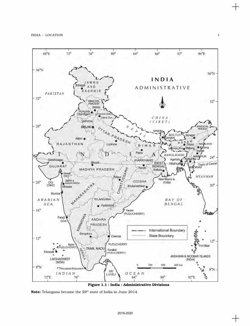
You have already seen the map of Indiain the previous classes. Now you closelyexamine the map of India (Figure 1.1).
Mark the southernmost and northernmostlatitudes and the easternmost andwesternmost longitudes.
The mainland of India, extends fromKashmir in the north to Kanniyakumari in thesouth and Arunachal Pradesh in the east toGujarat in the west. India’s territorial limitfurther extends towards the sea upto 12nautical miles (about 21.9 km) from the coast.(See the box for conversion).
Statute mile = 63,360 inchesNautical mile = 72,960 inches1 Statute mile = about 1.6 km (1.584 km)1 Nautical mile = about 1.8 km (1.852 km)
Our southern boundary extends upto6°45' N latitude in the Bay of Bengal. Let ustry to analyse the implications of having sucha vast longitudinal and latitudinal extent.
If you work out the latitudinal andlongitudinal extent of India, they are roughlyabout 30 degrees, whereas the actual distancemeasured from north to south extremity is3,214 km, and that from east to west is only2,933 km. What is the reason for thisdifference? Consult Chapter 3 on the topicLatitude, Longitude and Time in the book
Practical Work in Geography – Part I (NCERT,2006) to find out.
This difference is based on the fact that thedistance between two longitudes decreasestowards the poles whereas the distancebetween two latitudes remains the sameeverywhere. Find out the distance between twolatitudes?
From the values of latitude, it is understoodthat the southern part of the country lieswithin the tropics and the northern part lies inthe sub-tropical zone or the warm temperatezone. This location is responsible for largevariations in land forms, climate, soil types andnatural vegetation in the country.
Now, let us observe the longitudinal extentand its implications on the Indian people. Fromthe values of longitude, it is quite discerniblethat there is a variation of nearly 30 degrees,which causes a time difference of nearly twohours between the easternmost and thewesternmost parts of our country. You arefamiliar with the concept of Indian StandardTime (IST). What is the use of the standardmeridian? While the sun rises in thenortheastern states about two hours earlier ascompared to Jaisalmer, the watches inDibrugarh, Imphal in the east and Jaisalmer,Bhopal or Chennai in the other parts of Indiashow the same time. Why does this happen?
INDIA – LOCATION
C H A P T E R
There is a general understanding among the countries of the world to select the standardmeridian in multiples of 7°30' of longitude. That is why 82°30' E has been selected as the‘standard meridian’ of India. Indian Standard Time is ahead of Greenwich Mean Time by5 hours and 30 minutes.
There are some countries where there are more than one standard meridian due totheir vast east-to-west extent. For example, the USA has seven time zones.
Do you Remember?
2019-2020
3INDIA – LOCATION
Figure 1.1 : India : Administrative Divisions
Note: Telangana became the 29th state of India in June 2014.
2019-2020
4IN
DIA
:
PH
YS
ICA
L E
NV
IRO
NM
EN
T
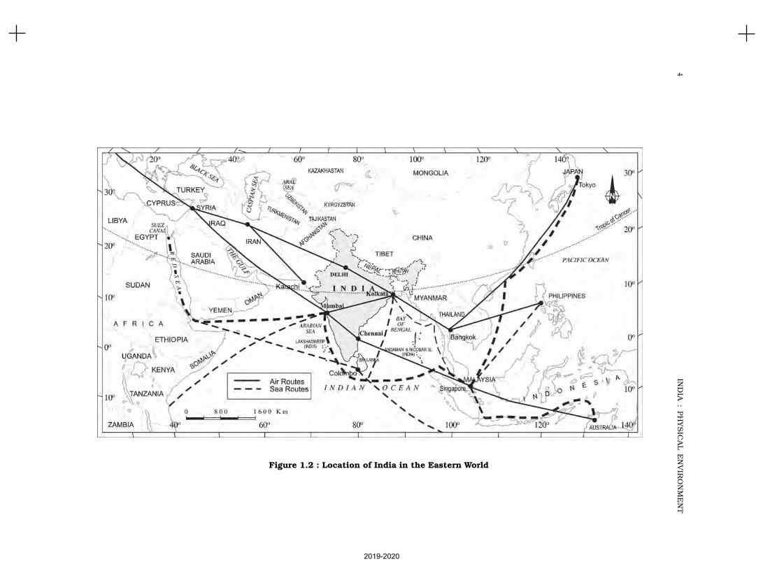
Figure 1.2 : Location of India in the Eastern World
2019-2020
5INDIA – LOCATION
Name a few places in India through which thestandard meridian passes?
India with its area of 3.28 million sq. kmaccounts for 2.4 per cent of the world’s landsurface area and stands as the seventhlargest country in the world. Find out thenames of the countries which are larger thanIndia.
SIZE
The size of India has endowed her with great
physical diversity. Thus, you may appreciate
the presence of lofty mountains in the north;
large rivers such as Ganga, Brahmaputra,Mahanadi, Krishna, Godavari and Kaveri;
green forested hills in northeast and south
India; and the vast sandy expanse of
Marusthali. You may further appreciate thatbounded by the Himalayas in the north,
Hindukush and Sulaiman ranges in the north-
west, Purvachal hills in the north-east and by
the large expanse of the Indian ocean in thesouth, it forms a great geographic entity known
as the Indian subcontinent. It includes the
countries — Pakistan, Nepal, Bhutan,
Bangladesh and India. The Himalayas,together with other ranges, have acted as a
formidable physical barrier in the past. Except
for a few mountain passes such as the Khyber,
the Bolan, the Shipkila, the Nathula, theBomdila, etc. it was difficult to cross it. It has
contributed towards the evolving of a unique
regional identity of the Indian subcontinent.
By referring to the physical map of Indiayou can now describe the physical variations
which you would come across while travelling
from Kashmir to Kanniyakumari and from
Jaisalmer in Rajasthan to Imphal in Manipur.Peninsular part of India extends towards
the Indian Ocean. This has provided the
country with a coastline of 6,100 km in the
mainland and 7,517 km in the entire
geographical coast of the mainland plus theisland groups Andaman and Nicobar locatedin the Bay of Bengal and the Lakshadweep inthe Arabian Sea. Thus India, as a country, isa physically diverse land providing occurrenceof varied resources.
INDIA AND ITS NEIGHBOURS
Examine the location map of India (Figure 1.2).You will notice that India is located in thesouth-central part of the continent of Asia,bordering the Indian ocean and its two armsextending in the form of Bay of Bengal and theArabian Sea. This maritime location ofPeninsular India has provided links to itsneighbouring regions through the sea and airroutes.
Prepare a list of India’s neighbouringcountries by consulting the map.
Sri Lanka and Maldives are the two islandcountries located in the Indian Ocean, whichare our neighbours. Sri Lanka is separated fromIndia by the Gulf of Mannar and Palk Strait.
Differentiate between a Gulf and a Strait.
Do you think that physical barrier is ahindrance in interaction with our neighbouringcountries in modern times? Give someexamples how we have overcome thesedifficulties in the present day.
Do you Remember?
School Bhuvan is a portal providing
map-based learning to bring awareness
among the students about country’s
natural resources, environment and
their role in sustainable development.
It is an initiative of Bhuvan-NRSC/
ISRO, based on NCERT syllabus.
You can explore various maps of India
on http://bhuvan-app1.nrs.gov.in/
mhrd-ncert/
2019-2020
6 INDIA : PHYSICAL ENVIRONMENT
1. Choose the right answer from the four alternatives given below.
(i) Which one of the following latitudinal extent is relevant for the extent ofIndia’s area?
(a) 8°41'N - 35°7'N (c) 8°4'N - 35°6'N
(b) 8°4'N - 37°6'N (d) 6°45'N - 37°6'N
(ii) Which one of the following countries shares the longest land frontier withIndia?
(a) Bangladesh (c) Pakistan(b) China (d) Myanmar
(iii) Which one of the following countries is larger in area than India?
(a) China (c) France
(b) Egypt (d) Iran
(iv) Which one of the following longitudes is the standard meridian for India?
(a) 69°30'E (c) 75°30'E
(b) 82°30'E (d) 90°30'E
2. Answer the following questions in about 30 words.
(i) Does India need to have more than one standard time? If yes, why do youthink so?
(ii) What are the implications of India having a long coastline?
(iii) How is the latitudinal spread of India advantageous to her?
(iv) While the sun rises earlier in the east, say Nagaland and also sets earlier,how do the watches at Kohima and New Delhi show the same time?
Project/Activity
Activity based on Appendix I (Teachers may help in the exercises by explaining
and getting it done by the students).
(i) On a graph paper, plot the number of districts in Madhya Pradesh,Karnataka, Meghalaya, Goa, Kerala, Haryana. Do the number of districtshave some relationship with the area of the state?
(ii) Which state amongst Uttar Pradesh, West Bengal, Gujarat, ArunachalPradesh, Tamil Nadu, Tripura, Rajasthan and Jammu and Kashmir isthe most thickly populated and which one is the least densely populated?
(iii) Find out the relationship between the area of the state and the number ofdistricts.
(iv) Identify the states with coastal boundaries.
(v) Arrange the states from west to east which have only land boundary.
Activity based on Appendix II
(i) List the Union Territories which have coastal location.
(ii) How do you explain the variation in the area and population of NCT Delhiand the Andaman and Nicobar Islands?
(iii) On a graph paper, draw a bar diagram to show the area and population ofall the Union Territories.
EXERCISES
2019-2020

PHYSIOGRAPHY
This unit deals with
• Structure and Relief; physiographic divisions
• Drainage systems: concept of water sheds — the Himalayan
and the Peninsular
UNIT
II
2019-2020

Do you know that our earth also has ahistory. The earth and its landformsthat we see today have evolved over a
very long time. Current estimation shows thatthe earth is approximately 460 million years old.Over these long years, it has undergone manychanges brought about primarily by theendogenic and exogenic forces. These forces haveplayed a significant role in giving shape to varioussurface and subsurface features of the earth. Youhave already studied about the Plate Tectonicsand the movement of the Earth’s plates in thebook Fundamentals of Physical Geography
(NCERT, 2006). Do you know that the Indianplate was to the south of the equator millions ofyears ago? Do you also know that it was muchlarger in size and the Australian plate was a partof it? Over millions of years, this plate broke intomany parts and the Australian plate movedtowards the southeastern direction and theIndian plate to the north. Can you map differentphases in the movement of the Indian plate? Thisnorthward movement of the Indian plate is stillcontinuing and it has significant consequenceson the physical environment of the Indiansubcontinent. Can you name some importantconsequences of the northward movement of theIndian plate?
It is primarily through the interplay of theseendogenic and exogenic forces and lateralmovements of the plates that the present geologicalstructure and geomorphologic processes activein the Indian subcontinent came into existence.Based on the variations in its geological structureand formations, India can be divided into threegeological divisions. These geological regionsbroadly follow the physical features:
(i) The Penisular Block(ii) The Himalayas and other Peninuslar
Mountains(iii) Indo-Ganga-Brahmaputra Plain.
THE PENINSULAR BLOCK
The northern boundary of the PeninsularBlock may be taken as an irregular linerunning from Kachchh along the western flankof the Aravali Range near Delhi and thenroughly parallel to the Yamuna and the Gangaas far as the Rajmahal Hills and the Gangadelta. Apart from these, the Karbi Anglong andthe Meghalaya Plateau in the northeast andRajasthan in the west are also extensions ofthis block. The northeastern parts areseparated by the Malda fault in West Bengalfrom the Chotanagpur plateau. In Rajasthan,the desert and other desert–like featuresoverlay this block.
The Peninsula is formed essentially by agreat complex of very ancient gneisses andgranites, which constitutes a major part of it.Since the Cambrian period, the Peninsula hasbeen standing like a rigid block with theexception of some of its western coast whichis submerged beneath the sea and some otherparts changed due to tectonic activity withoutaffecting the original basement. As a part ofthe Indo-Australian Plate, it has been subjectedto various vertical movements and blockfaulting. The rift valleys of the Narmada, theTapi and the Mahanadi and the Satpura blockmountains are some examples of it. ThePeninsula mostly consists of relict and residualmountains like the Aravali hills, the Nallamalahills, the Javadi hills, the Veliconda hills, the
STRUCTURE AND PHYSIOGRAPHY
C H A P T E R
2019-2020
9STRUCTURE AND PHYSIOGRAPHY
Palkonda range and the Mahendragiri hills, etc.The river valleys here are shallow with lowgradients.
You are aware of the method of calculatingthe gradient as a part of your study of the bookPractical Work in Geography– Part I (NCERT,2006). Can you calculate the gradient of theHimalayan and the Peninsular rivers and drawthe comparisons?
Most of the east flowing rivers form deltasbefore entering into the Bay of Bengal. Thedeltas formed by the Mahanadi, the Krishna,the Kaveri and the Godavari are importantexamples.
THE HIMALAYAS AND OTHER
PENINSULAR MOUNTAINS
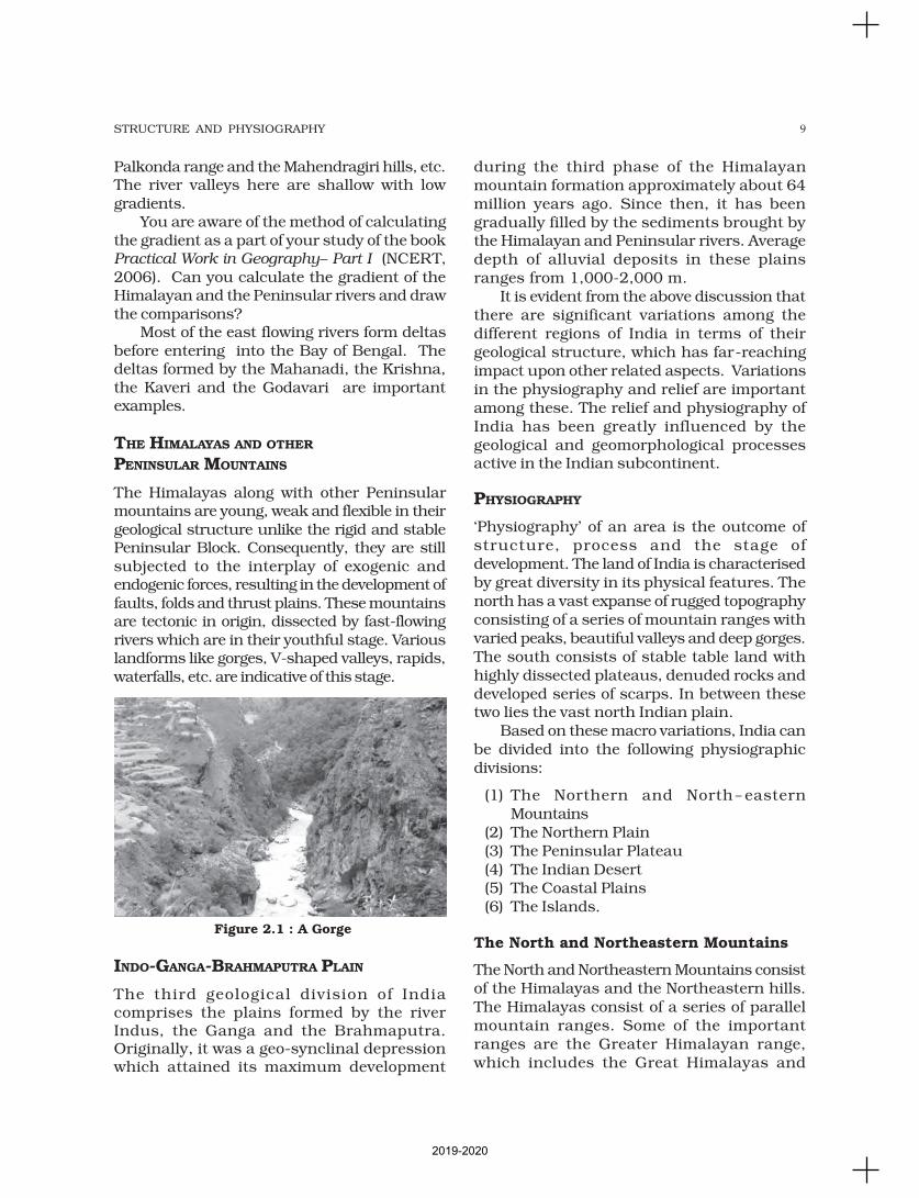
The Himalayas along with other Peninsularmountains are young, weak and flexible in theirgeological structure unlike the rigid and stablePeninsular Block. Consequently, they are stillsubjected to the interplay of exogenic andendogenic forces, resulting in the development offaults, folds and thrust plains. These mountainsare tectonic in origin, dissected by fast-flowingrivers which are in their youthful stage. Variouslandforms like gorges, V-shaped valleys, rapids,waterfalls, etc. are indicative of this stage.
INDO-GANGA-BRAHMAPUTRA PLAIN
The third geological division of Indiacomprises the plains formed by the riverIndus, the Ganga and the Brahmaputra.Originally, it was a geo-synclinal depressionwhich attained its maximum development
during the third phase of the Himalayanmountain formation approximately about 64million years ago. Since then, it has beengradually filled by the sediments brought bythe Himalayan and Peninsular rivers. Averagedepth of alluvial deposits in these plainsranges from 1,000-2,000 m.
It is evident from the above discussion thatthere are significant variations among thedifferent regions of India in terms of theirgeological structure, which has far-reachingimpact upon other related aspects. Variationsin the physiography and relief are importantamong these. The relief and physiography ofIndia has been greatly influenced by thegeological and geomorphological processesactive in the Indian subcontinent.
PHYSIOGRAPHY
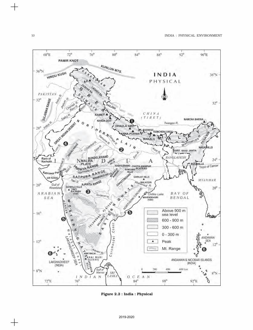
‘Physiography’ of an area is the outcome ofstructure, process and the stage ofdevelopment. The land of India is characterisedby great diversity in its physical features. Thenorth has a vast expanse of rugged topographyconsisting of a series of mountain ranges withvaried peaks, beautiful valleys and deep gorges.The south consists of stable table land withhighly dissected plateaus, denuded rocks anddeveloped series of scarps. In between thesetwo lies the vast north Indian plain.
Based on these macro variations, India canbe divided into the following physiographicdivisions:
(1) The Northern and North-easternMountains
(2) The Northern Plain(3) The Peninsular Plateau(4) The Indian Desert(5) The Coastal Plains(6) The Islands.
The North and Northeastern Mountains
The North and Northeastern Mountains consistof the Himalayas and the Northeastern hills.The Himalayas consist of a series of parallelmountain ranges. Some of the importantranges are the Greater Himalayan range,which includes the Great Himalayas and
Figure 2.1 : A Gorge
2019-2020
10 INDIA : PHYSICAL ENVIRONMENT
Figure 2.2 : India : Physical
2019-2020

11STRUCTURE AND PHYSIOGRAPHY
the Shiwalik. The general orientation of theseranges is from northwest to the southeastdirection in the northwestern part of India.Himalayas in the Darjiling and Sikkim regionslie in an eastwest direction, while in ArunachalPradesh they are from southwest to thenorthwest direction. In Nagaland, Manipur andMizoram, they are in the northsouth direction.The approximate length of the Great Himalayanrange, also known as the central axial range, is2,500 km from east to west, and their widthvaries between 160-400 km from north tosouth. It is also evident from the map that theHimalayas stand almost like a strong and longwall between the Indian subcontinent and theCentral and East Asian countries.
Himalayas are not only the physical barrier,they are also a climatic, drainage and culturaldivide. Can you identify the impact of Himalayason the geoenvironment of the countries of SouthAsia? Can you find some other examples ofsimilar geoenvironmental divide in the world?
There are large-scale regional variationswithin the Himalayas. On the basis of relief,alignment of ranges and other geomorphologicalfeatures, the Himalayas can be divided into thefollowing sub-divisions:
(i) Kashmir or Northwestern Himalayas(ii) Himachal and Uttarakhand Himalayas(iii) Darjiling and Sikkim Himalayas(iv) Arunachal Himalayas(v) Eastern Hills and Mountains.
Kashmir or Northwestern Himalayas
It comprise a series of ranges such as theKarakoram, Ladakh, Zaskar and Pir Panjal. Thenortheastern part of the Kashmir Himalayas is acold desert, which lies between the GreaterHimalayas and the Karakoram ranges. Between
the Great Himalayas and the Pir Panjal range,lies the world famous valley of Kashmir and thefamous Dal Lake. Important glaciers of SouthAsia such as the Baltoro and Siachen are alsofound in this region. The Kashmir Himalayas are
also famous for Karewaformations, which are usefulfor the cultivation of Zafran,a local variety of saffron.Some of the importantpasses of the region are ZojiLa on the Great Himalayas,Banihal on the Pir Panjal,
Photu La on the Zaskar and Khardung La onthe Ladakh range. Some of the important freshlakes such as Dal and Wular and salt water lakessuch as Pangong Tso and Tso Moriri are also inthis region. This region is drained by the riverIndus, and its tributaries such as the Jhelumand the Chenab. The Kashmir and northwesternHimalayas are well-known for their scenicbeauty and picturesque landscape. Thelandscape of Himalayas is a major source ofattraction for adventure tourists. Do you knowthat some famous places of pilgrimage such asVaishno Devi, Amarnath Cave, Charar -e-Sharif,etc. are also located here and large number ofpilgrims visit these places every year?
Srinagar, capital city of the state of Jammuand Kashmir is located on the banks of Jhelumriver. Dal Lake in Srinagar presents aninteresting physical feature. Jhelum in the valleyof Kashmir is still in its youth stage and yet formsmeanders – a typical feature associated with themature stage in the evolution of fluvial land form(Figure 2.4). Can you name some other fluviallandforms in the mature stage of a river?
Figure 2.3 : The Himalayas
KarewasKarewas are thethick deposits ofglacial clay andother materialsembedded withmoraines.
Figure 2.4 : Meandering Jhelum
2019-2020
12 INDIA : PHYSICAL ENVIRONMENT
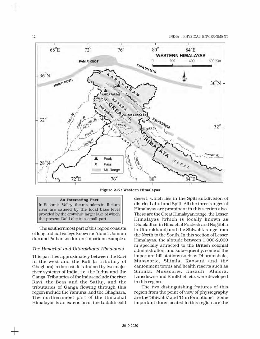
The southernmost part of this region consistsof longitudinal valleys known as ‘duns’. Jammudun and Pathankot dun are important examples.
The Himachal and Uttarakhand Himalayas
This part lies approximately between the Raviin the west and the Kali (a tributary ofGhaghara) in the east. It is drained by two majorriver systems of India, i.e. the Indus and theGanga. Tributaries of the Indus include the riverRavi, the Beas and the Satluj, and thetributaries of Ganga flowing through thisregion include the Yamuna and the Ghaghara.The northernmost part of the HimachalHimalayas is an extension of the Ladakh cold
desert, which lies in the Spiti subdivision ofdistrict Lahul and Spiti. All the three ranges ofHimalayas are prominent in this section also.These are the Great Himalayan range, the LesserHimalayas (which is locally known asDhaoladhar in Himachal Pradesh and Nagtibhain Uttarakhand) and the Shiwalik range fromthe North to the South. In this section of LesserHimalayas, the altitude between 1,000-2,000m specially attracted to the British colonialadministration, and subsequently, some of theimportant hill stations such as Dharamshala,Mussoorie, Shimla, Kaosani and thecantonment towns and health resorts such asShimla, Mussoorie, Kasauli, Almora,Lansdowne and Ranikhet, etc. were developedin this region.
The two distinguishing features of thisregion from the point of view of physiographyare the ‘Shiwalik’ and ‘Dun formations’. Someimportant duns located in this region are the
An Interesting FactIn Kashmir Valley, the meanders in Jhelumriver are caused by the local base levelprovided by the erstwhile larger lake of whichthe present Dal Lake is a small part.
Figure 2.5 : Western Himalayas
2019-2020
13STRUCTURE AND PHYSIOGRAPHY
Chandigarh-Kalka dun, Nalagarh dun, DehraDun, Harike dun and the Kota dun, etc. Dehra
Dun is the largest of all the duns with anapproximate length of 35-45 km and a widthof 22-25 km. In the Great Himalayan range,the valleys are mostly inhabited by theBhotia’s. These are nomadic groups whomigrate to ‘Bugyals’ (the summer glasslandsin the higher reaches) during summer monthsand return to the valleys during winters. Thefamous ‘Valley of flowers’ is also situated in thisregion. The places of pilgrimage such as theGangotri, Yamunotri, Kedarnath, Badrinathand Hemkund Sahib are also situated in thispart. The region is also known to have fivefamous Prayags (river confluences) asmentiond in Chapter 3 of this book. Can youname some other famous prayags in otherparts of the country?
The Darjiling and Sikkim Himalayas
They are flanked by Nepal Himalayas in thewest and Bhutan Himalayas in the east. It isrelatively small but is a most significant partof the Himalayas. Known for its fast-flowing
rivers such as Tista, it is a region of highmountain peaks like Kanchenjunga(Kanchengiri), and deep valleys. The higherreaches of this region are inhabited by Lepchatribes while the southern part, particularly theDarjiling Himalayas, has a mixed populationof Nepalis, Bengalis and tribals from CentralIndia. The British, taking advantage of thephysical conditions such as moderate slope,thick soil cover with high organic content, welldistributed rainfall throughout the year andmild winters, introduced tea plantations in thisregion. As compared to the other sections ofthe Himalayas, these along with the ArunachalHimalayas are conspicuous by the absence ofthe Shiwalik formations. In place of theShiwaliks here, the ‘duar formations’ areimportant, which have also been used for thedevelopment of tea gardens. Sikkim andDarjiling Himalayas are also known for theirscenic beauty and rich flora and fauna,particularly various types of orchids.
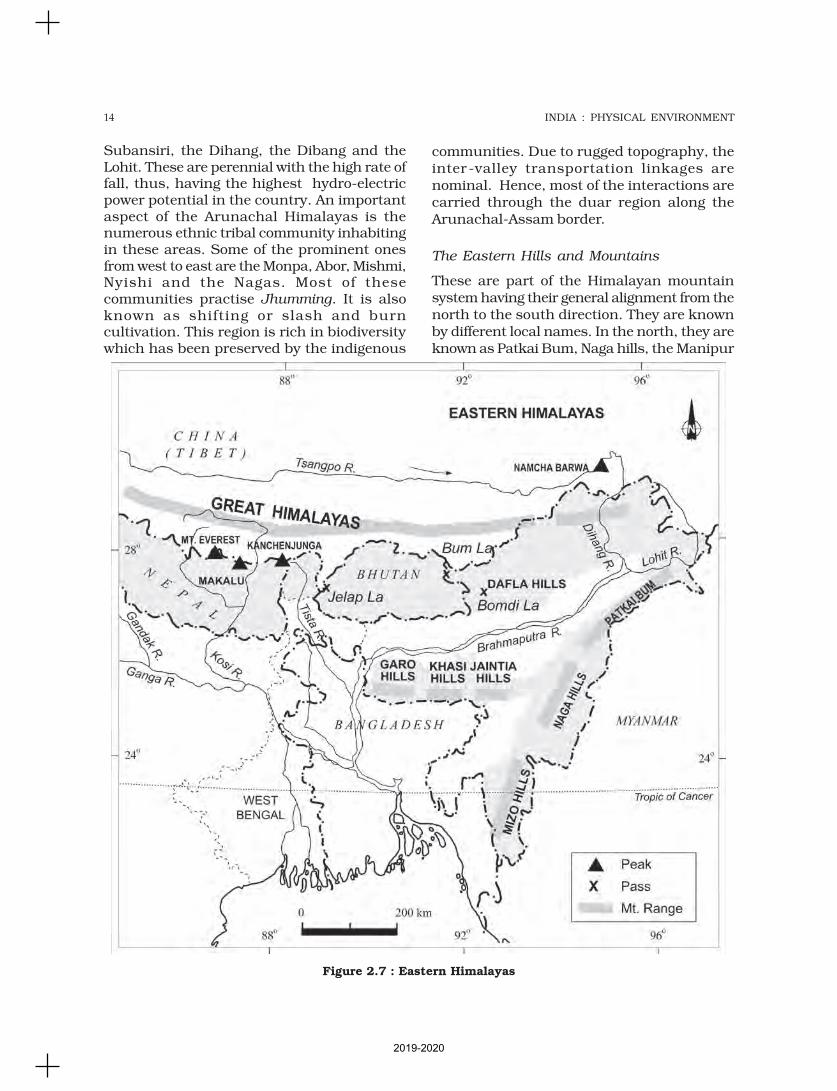
The Arunachal Himalayas
These extend from the east of the BhutanHimalayas up to the Diphu pass in the east.The general direction of the mountain range isfrom southwest to northeast. Some of theimportant mountain peaks of the region areKangtu and Namcha Barwa. These ranges aredissected by fast-flowing rivers from the northto the south, forming deep gorges.Bhramaputra flows through a deep gorge aftercrossing Namcha Barwa. Some of theimportant rivers are the Kameng, the
The ShiwalikThe word shiwalik has its origin in thegeological formation found in and arounda place called Sivawala near Dehra Dunwhich was once a headquarter of theImperial Survey and which subsequentlyestablished its permanent headquartersat Dehra Dun.
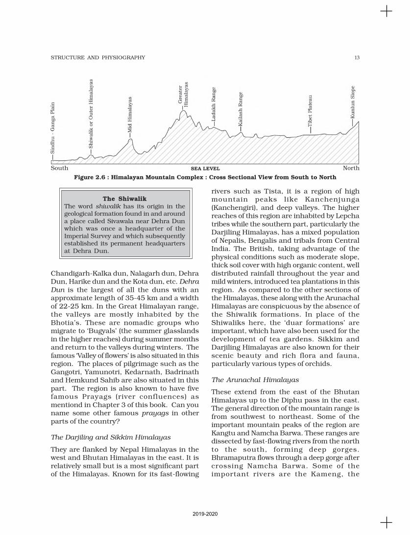
Figure 2.6 : Himalayan Mountain Complex : Cross Sectional View from South to North
South North
2019-2020
14 INDIA : PHYSICAL ENVIRONMENT
Subansiri, the Dihang, the Dibang and theLohit. These are perennial with the high rate offall, thus, having the highest hydro-electricpower potential in the country. An importantaspect of the Arunachal Himalayas is thenumerous ethnic tribal community inhabitingin these areas. Some of the prominent onesfrom west to east are the Monpa, Abor, Mishmi,Nyishi and the Nagas. Most of thesecommunities practise Jhumming. It is alsoknown as shifting or slash and burncultivation. This region is rich in biodiversitywhich has been preserved by the indigenous
Figure 2.7 : Eastern Himalayas
communities. Due to rugged topography, theinter -valley transportation linkages arenominal. Hence, most of the interactions arecarried through the duar region along theArunachal-Assam border.
The Eastern Hills and Mountains
These are part of the Himalayan mountainsystem having their general alignment from thenorth to the south direction. They are knownby different local names. In the north, they areknown as Patkai Bum, Naga hills, the Manipur
2019-2020
15STRUCTURE AND PHYSIOGRAPHY
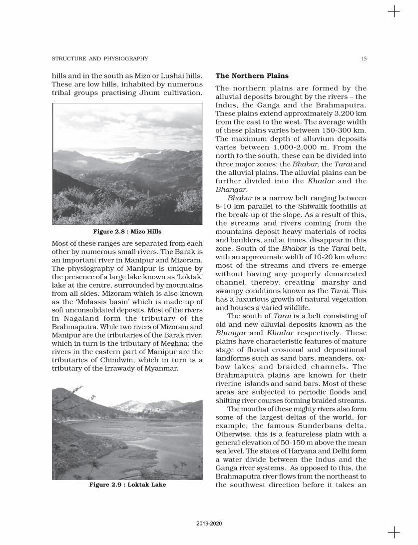
Figure 2.8 : Mizo Hills
Figure 2.9 : Loktak Lake
hills and in the south as Mizo or Lushai hills.These are low hills, inhabited by numeroustribal groups practising Jhum cultivation.
Most of these ranges are separated from eachother by numerous small rivers. The Barak isan important river in Manipur and Mizoram.The physiography of Manipur is unique bythe presence of a large lake known as ‘Loktak’lake at the centre, surrounded by mountainsfrom all sides. Mizoram which is also knownas the ‘Molassis basin’ which is made up ofsoft unconsolidated deposits. Most of the riversin Nagaland form the tributary of theBrahmaputra. While two rivers of Mizoram andManipur are the tributaries of the Barak river,which in turn is the tributary of Meghna; therivers in the eastern part of Manipur are thetributaries of Chindwin, which in turn is atributary of the Irrawady of Myanmar.
The Northern Plains
The northern plains are formed by thealluvial deposits brought by the rivers – theIndus, the Ganga and the Brahmaputra.These plains extend approximately 3,200 kmfrom the east to the west. The average widthof these plains varies between 150-300 km.The maximum depth of alluvium depositsvaries between 1,000-2,000 m. From thenorth to the south, these can be divided intothree major zones: the Bhabar, the Tarai andthe alluvial plains. The alluvial plains can befurther divided into the Khadar and theBhangar.
Bhabar is a narrow belt ranging between8-10 km parallel to the Shiwalik foothills atthe break-up of the slope. As a result of this,the streams and rivers coming from themountains deposit heavy materials of rocksand boulders, and at times, disappear in thiszone. South of the Bhabar is the Tarai belt,with an approximate width of 10-20 km wheremost of the streams and rivers re-emergewithout having any properly demarcatedchannel, thereby, creating marshy andswampy conditions known as the Tarai. Thishas a luxurious growth of natural vegetationand houses a varied wildlife.
The south of Tarai is a belt consisting ofold and new alluvial deposits known as theBhangar and Khadar respectively. Theseplains have characteristic features of maturestage of fluvial erosional and depositionallandforms such as sand bars, meanders, ox-bow lakes and braided channels. TheBrahmaputra plains are known for theirriverine islands and sand bars. Most of theseareas are subjected to periodic floods andshifting river courses forming braided streams.
The mouths of these mighty rivers also formsome of the largest deltas of the world, forexample, the famous Sunderbans delta.Otherwise, this is a featureless plain with ageneral elevation of 50-150 m above the meansea level. The states of Haryana and Delhi forma water divide between the Indus and theGanga river systems. As opposed to this, theBrahmaputra river flows from the northeast tothe southwest direction before it takes an
2019-2020

16 INDIA : PHYSICAL ENVIRONMENT
almost 90° southward turn at Dhubri beforeit enters into Bangladesh. These river valleyplains have a fertile alluvial soil cover whichsupports a variety of crops like wheat, rice,sugarcane and jute, and hence, supports alarge population.
The Peninsular Plateau
Rising from the height of 150 m above the riverplains up to an elevation of 600-900 m is theirregular triangle known as the Peninsularplateau. Delhi ridge in the northwest, (extensionof Aravalis), the Rajmahal hills in the east, Girrange in the west and the Cardamom hills inthe south constitute the outer extent of thePeninsular plateau. However, an extension ofthis is also seen in the northeast, in the form ofShillong and Karbi-Anglong plateau. ThePeninsular India is made up of a series ofpatland plateaus such as the Hazaribaghplateau, the Palamu plateau, the Ranchiplateau, the Malwa plateau, the Coimbatore
Figure 2.10 : Northern Plain
Figure 2.11 : A Part of Peninsular Plateau
plateau and the Karnataka plateau, etc. Thisis one of the oldest and the most stablelandmass of India. The general elevation of theplateau is from the west to the east, which isalso proved by the pattern of the flow of rivers.Name some rivers of the Peninsular plateauwhich have their confluence in the Bay ofBengal and the Arabian sea and mention somelandforms which are typical to the east flowingrivers but are absent in the west flowing rivers.Some of the important physiographic featuresof this region are tors, block mountains, riftvalleys, spurs, bare rocky structures, series ofhummocky hills and wall-like quartzite dykesoffering natural sites for water storage. Thewestern and northwestern part of the plateauhas an emphatic presence of black soil.
This Peninsular plateau has undergonerecurrent phases of upliftment andsubmergence accompanied by crustal faultingand fractures. (The Bhima fault needs specialmention, because of its recurrent seismicactivities). These spatial variations havebrought in elements of diversity in the relief ofthe Peninsular plateau. The northwestern partof the plateau has a complex relief of ravinesand gorges. The ravines of Chambal, Bhind andMorena are some of the well-known examples.
On the basis of the prominent relieffeatures, the Peninsular plateau can be dividedinto three broad groups:
(i) The Deccan Plateau(ii) The Central Highlands(iii) The Northeastern Plateau.
The Deccan Plateau
This is bordered by the Western Ghats in thewest, Eastern Ghats in the east and theSatpura, Maikal range and Mahadeo hills inthe north. Western Ghats are locally knownby different names such as Sahyadri inMaharashtra, Nilgiri hills in Karnataka andTamil Nadu and Anaimalai hills andCardamom hills in Kerala. Western Ghats arecomparatively higher in elevation and morecontinuous than the Eastern Ghats. Theiraverage elevation is about 1,500 m with theheight increasing from north to south.‘Anaimudi’ (2,695 m), the highest peak of
2019-2020
17STRUCTURE AND PHYSIOGRAPHY
Peninsular plateau is located on the Anaimalaihills of the Western Ghats followed by Dodabetta(2,637 m) on the Nilgiri hills. Most of thePeninsular rivers have their origin in theWestern Ghats. Eastern Ghats comprising thediscontinuous and low hills are highly erodedby the rivers such as the Mahanadi, theGodavari, the Krishna, the Kaveri, etc. Some ofthe important ranges include the Javadi hills,the Palconda range, the Nallamala hills, theMahendragiri hills, etc. The Eastern and theWestern Ghats meet each other at the Nilgiri hills.
The Central Highlands
They are bounded to the west by the Aravalirange. The Satpura range is formed by a seriesof scarped plateaus on the south, generally atan elevation varying between 600-900 m abovethe mean sea level. This forms thenorthernmost boundary of the Deccan plateau.It is a classic example of the relict mountainswhich are highly denuded and formdiscontinuous ranges. The extension of thePeninsular plateau can be seen as far asJaisalmer in the West, where it has beencovered by the longitudinal sand ridges andcrescent-shaped sand dunes called barchans.This region has undergone metamorphicprocesses in its geological history, which canbe corroborated by the presence ofmetamorphic rocks such as marble, slate,gneiss, etc.
The general elevation of the CentralHighlands ranges between 700-1,000 m abovethe mean sea level and it slopes towards thenorth and northeastern directions. Most of thetributaries of the river Yamuna have their originin the Vindhyan and Kaimur ranges. Banas isthe only significant tributary of the riverChambal that originates from the Aravalli inthe west. An eastern extension of the CentralHighland is formed by the Rajmahal hills, tothe south of which lies a large reserve ofmineral resources in the Chotanagpurplateau.
The Northeastern Plateau
In fact it is an extension of the main Peninsularplateau. It is believed that due to the force
exerted by the northeastward movement of theIndian plate at the time of the Himalayanorigin, a huge fault was created between theRajmahal hills and the Meghalaya plateau.Later, this depression got filled up by thedeposition activity of the numerous rivers.Today, the Meghalaya and Karbi Anglongplateau stand detached from the mainPeninsular Block. The Meghalaya plateau isfurther sub-divided into three: (i) The GaroHills; (ii) The Khasi Hills; (iii) The Jaintia Hills,named after the tribal groups inhabiting thisregion. An extension of this is also seen in theKarbi Anglong hills of Assam. Similar to theChotanagpur plateau, the Meghalaya plateauis also rich in mineral resources like coal, ironore, sillimanite, limestone and uranium. Thisarea receives maximum rainfall from the southwest monsoon. As a result, the Meghalayaplateau has a highly eroded surface.Cherrapunji displays a bare rocky surfacedevoid of any permanent vegetation cover.
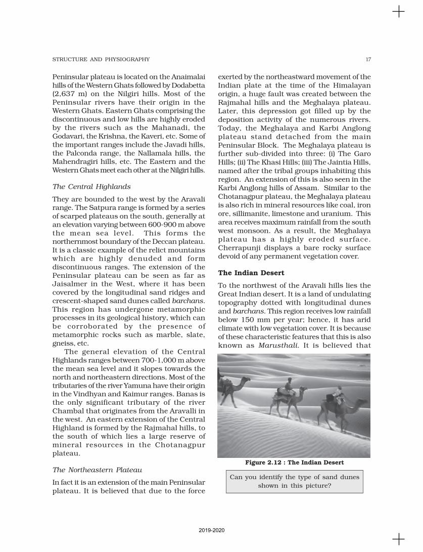
The Indian Desert
To the northwest of the Aravali hills lies theGreat Indian desert. It is a land of undulatingtopography dotted with longitudinal dunesand barchans. This region receives low rainfallbelow 150 mm per year; hence, it has aridclimate with low vegetation cover. It is becauseof these characteristic features that this is alsoknown as Marusthali. It is believed that
Figure 2.12 : The Indian Desert
Can you identify the type of sand dunes
shown in this picture?
2019-2020

18 INDIA : PHYSICAL ENVIRONMENT
Kathiawar coast in Gujarat, Konkan coast inMaharashtra, Goan coast and Malabar coastin Karnataka and Kerala respectively. Thewestern coastal plains are narrow in themiddle and get broader towards north andsouth. The rivers flowing through this coastalplain do not form any delta. The Malabarcoast has got certain distinguishing featuresin the form of ‘Kayals’ (backwaters), whichare used for fishing, inland navigation and alsodue to its special attraction for tourists. Everyyear the famous Nehru Trophy Vallamkali
(boat race) is held in Punnamada Kayal inKerala.
As compared to the western coastal plain,the eastern coastal plain is broader and is anexample of an emergent coast. There are well-developed deltas here, formed by the riversflowing eastward in to the Bay of Bengal. Theseinclude the deltas of the Mahanadi, theGodavari, the Krishna and the Kaveri. Becauseof its emergent nature, it has less number ofports and harbours. The continental shelfextends up to 500 km into the sea, whichmakes it difficult for the development of goodports and harbours. Name some ports on theeastern coast.
The Islands
There are two major island groups in India –one in the Bay of Bengal and the other in theArabian Sea. The Bay of Bengal island groupsconsist of about 572 islands/islets. These aresituated roughly between 6°N-14°N and92°E -94°E. The two principal groups of isletsinclude the Ritchie’s archipelago and theLabrynth island. The entire group of island is
Figure 2.13 : Coastal Plains
during the Mesozoic era, this region was underthe sea. This can be corroborated by theevidence available at wood fossils park at Aakaland marine deposits around Brahmsar, nearJaisalmer (The approximate age of the wood-fossils is estimated to be 180 million years).Though the underlying rock structure of thedesert is an extension of the Peninsularplateau, yet, due to extreme arid conditions,its surface features have been carved byphysical weathering and wind actions. Someof the well pronounced desert land featurespresent here are mushroom rocks, shiftingdunes and oasis (mostly in its southern part).On the basis of the orientation, the desert canbe divided into two parts: the northern part issloping towards Sindh and the southerntowards the Rann of Kachchh. Most of the riversin this region are ephemeral. The Luni riverflowing in the southern part of the desert is ofsome significance. Low precipitation and highevaporation makes it a water deficit region.There are some streams which disappear afterflowing for some distance and present a typicalcase of inland drainage by joining a lake orplaya. The lakes and the playas have brackishwater which is the main source of obtaining salt.
The Coastal Plains
You have already read that India has a longcoastline . On the basis of the location andactive geomorphological processes, it can be
broadly divided into two: (i) the western coastalplains; (ii) the eastern coastal plains.
The western coastal plains are an example
of submerged coastal plain. It is believed thatthe city of Dwaraka which was once a part ofthe Indian mainland situated along the west
coast is submerged under water. Because ofthis submergence it is a narrow belt andprovides natural conditions for the
development of ports and harbours. Kandla,Mazagaon, JLN port Navha Sheva, Marmagao,Mangalore, Cochin, etc. are some of the
important natural ports located along thewest coast. Extending from the Gujarat coastin the north to the Kerala coast in the south,
the western coast may be divided intofollowing divisions – the Kachchh and
2019-2020
19STRUCTURE AND PHYSIOGRAPHY
divided into two broad categories – theAndaman in the north and the Nicobar in thesouth. They are separated by a waterbodywhich is called the Ten degree channel. It isbelieved that these islands are an elevatedportion of submarine mountains. However,some smaller islands are volcanic in origin.Barren island, the only active volcano in Indiais also situated in the Nicobar islands.
Some important mountain peaks inAndaman and Nicobar Islands are Saddlepeak (North Andaman – 738 m), MountDiavolo (Middle Andaman – 515 m), MountKoyob (South Andaman – 460 m) andMount Thuiller (Great Nicobar – 642 m).
The coastal line has some coral deposits,and beautiful beaches. These islands receiveconvectional rainfall and have an equatorialtype of vegetation.
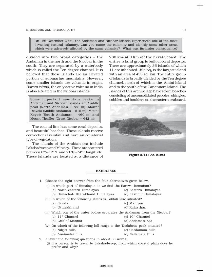
The islands of the Arabian sea includeLakshadweep and Minicoy. These are scatteredbetween 8°N-12°N and 71°E -74°E longitude.These islands are located at a distance of
280 km-480 km off the Kerala coast. Theentire island group is built of coral deposits.There are approximately 36 islands of which11 are inhabited. Minicoy is the largest islandwith an area of 453 sq. km. The entire groupof islands is broadly divided by the Ten degreechannel, north of which is the Amini Islandand to the south of the Canannore Island. TheIslands of this archipelago have storm beachesconsisting of unconsolidated pebbles, shingles,cobbles and boulders on the eastern seaboard.
On 26 December 2004, the Andaman and Nicobar Islands experienced one of the mostdevasting natural calamity. Can you name the calamity and identify some other areaswhich were adversely affected by the same calamity? What was its major consequence?
1. Choose the right answer from the four alternatives given below.
(i) In which part of Himalayas do we find the Karewa formation?
(a) North-eastern Himalayas (c) Eastern Himalayas
(b) Himachal-Uttarakhand Himalayas (d) Kashmir Himalayas
(ii) In which of the following states is Loktak lake situated?
(a) Kerala (c) Manipur
(b) Uttarakhand (d) Rajasthan
(iii) Which one of the water bodies separates the Andaman from the Nicobar?
(a) 11° Channel (c) 10° Channel
(b) Gulf of Mannar (d) Andaman Sea
(iv) On which of the following hill range is the ‘Dodabeta’ peak situated?
(a) Nilgiri hills (c) Cardamom hills
(b) Anaimalai hills (d) Nallamala hills
2. Answer the following questions in about 30 words.
(i) If a person is to travel to Lakshadweep, from which coastal plain does heprefer and why?
EXERCISES
Figure 2.14 : An Island
2019-2020

20 INDIA : PHYSICAL ENVIRONMENT
(ii) Where in India will you find a cold desert? Name some important ranges ofthis region.
(iii) Why is the western coastal plain is devoid of any delta?
3. Answer the following questions in not more than 125 words.
(i) Make a comparison of the island groups of the Arabian Sea and the Bay ofBengal.
(ii) What are the important geomorphological features found in the river valleyplains?
(iii) If you move from Badrinath to Sunderbans delta along the course of theriver Ganga, what major geomorphological features will you come across?
Project/Activity
(i) Make a list of major Himalayan peaks from the west to the east with the helpof an atlas.
(ii) Identify the major landforms of your state and analyse the major economicactivity practised by the people in each landform.
2019-2020
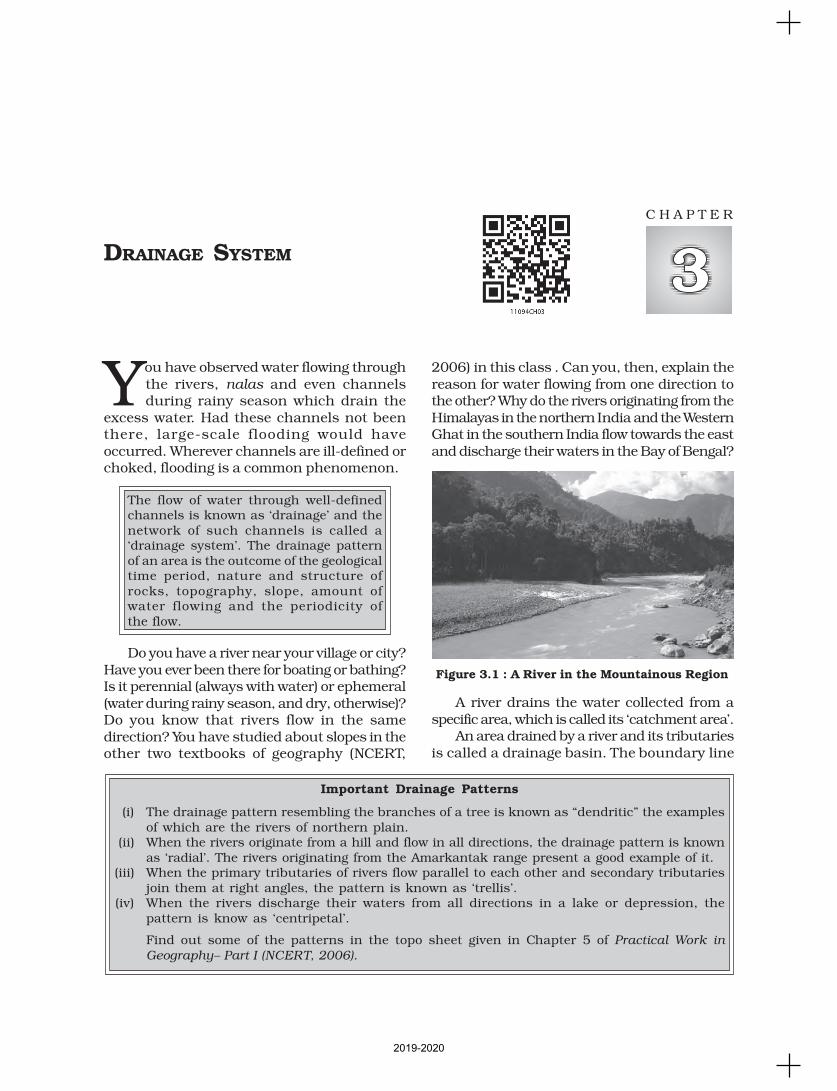
You have observed water flowing throughthe rivers, nalas and even channelsduring rainy season which drain the
excess water. Had these channels not beenthere, large-scale flooding would haveoccurred. Wherever channels are ill-defined orchoked, flooding is a common phenomenon.
The flow of water through well-definedchannels is known as ‘drainage’ and thenetwork of such channels is called a‘drainage system’. The drainage patternof an area is the outcome of the geologicaltime period, nature and structure ofrocks, topography, slope, amount ofwater flowing and the periodicity ofthe flow.
Do you have a river near your village or city?Have you ever been there for boating or bathing?Is it perennial (always with water) or ephemeral(water during rainy season, and dry, otherwise)?Do you know that rivers flow in the samedirection? You have studied about slopes in theother two textbooks of geography (NCERT,
2006) in this class . Can you, then, explain thereason for water flowing from one direction tothe other? Why do the rivers originating from theHimalayas in the northern India and the WesternGhat in the southern India flow towards the eastand discharge their waters in the Bay of Bengal?
A river drains the water collected from aspecific area, which is called its ‘catchment area’.
An area drained by a river and its tributariesis called a drainage basin. The boundary line
DRAINAGE SYSTEM
C H A P T E R
Figure 3.1 : A River in the Mountainous Region
Important Drainage Patterns
(i) The drainage pattern resembling the branches of a tree is known as “dendritic” the examplesof which are the rivers of northern plain.
(ii) When the rivers originate from a hill and flow in all directions, the drainage pattern is knownas ‘radial’. The rivers originating from the Amarkantak range present a good example of it.
(iii) When the primary tributaries of rivers flow parallel to each other and secondary tributariesjoin them at right angles, the pattern is known as ‘trellis’.
(iv) When the rivers discharge their waters from all directions in a lake or depression, thepattern is know as ‘centripetal’.
Find out some of the patterns in the topo sheet given in Chapter 5 of Practical Work in
Geography– Part I (NCERT, 2006).
2019-2020
22 INDIA : PHYSICAL ENVIRONMENT
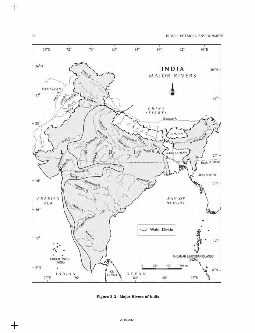
Figure 3.2 : Major Rivers of India
2019-2020
23DRAINAGE SYSTEM
separating one drainage basin from the otheris known as the watershed. The catchments oflarge rivers are called river basins while thoseof small rivulets and rills are often referred toas watersheds. There is, however, a slightdifference between a river basin and awatershed. Watersheds are small in area whilethe basins cover larger areas.
River basins and watersheds are markedby unity. What happens in one part of thebasin or watershed directly affects the otherparts and the unit as a whole. That is why, theyare accepted as the most appropriate micro,meso or macro planning regions.
Indian drainage system may be divided onvarious bases. On the basis of discharge of water(orientations to the sea), it may be grouped into:(i) the Arabian Sea drainage; and (ii) the Bay ofBengal drainage. They are separated from eachother through the Delhi ridge, the Aravalis andthe Sahyadris (water divide is shown by a linein Figure 3.1). Nearly 77 per cent of the drainagearea consisting of the Ganga, the Brahmaputra,the Mahanadi, the Krishna, etc. is orientedtowards the Bay of Bengal while 23 per centcomprising the Indus, the Narmada, the Tapi,the Mahi and the Periyar systems dischargetheir waters in the Arabian Sea.
On the basis of the size of the watershed,the drainage basins of India are grouped intothree categories: (i) Major river basins withmore than 20,000 sq. km of catchment area.It includes 14 drainage basins such as theGanga, the Brahmaputra, the Krishna, theTapi, the Narmada, the Mahi, the Pennar, theSabarmati, the Barak, etc. (Appendix III). (ii)Medium river basins with catchment areabetween 2,000-20,000 sq. km incorporating44 river basins such as the Kalindi, the Periyar,the Meghna, etc. (iii) Minor river basins withcatchment area of less than 2,000 sq. kminclude fairly good number of rivers flowing inthe area of low rainfall.
If you look at the Figure 3.1 you can seethat many rivers have their sources in theHimalayas and discharge their waters either inthe Bay of Bengal or in the Arabian Sea. Identifythese rivers of North India. Large rivers flowingon the Peninsular plateau have their origin inthe Western Ghats and discharge their waters
in the Bay of Bengal. Identify these rivers of theSouth India.
The Narmada and Tapi are two large riverswhich are exceptions. They along with manysmall rivers discharge their waters in theArabian Sea.
Name these rivers of the western coastalregion from the Konkan to the Malabar coast.
On the basis of the mode of origin, natureand characteristics, the Indian drainage mayalso be classified into the Himalayan drainageand the Peninsular drainage. Although it hasthe problem of including the Chambal, theBetwa, the Son, etc. which are much older inage and origin than other rivers that have theirorigin in the Himalayas, it is the most acceptedbasis of classification. Hence, this scheme hasbeen followed in this book.
DRAINAGE SYSTEMS OF INDIA
Indian drainage system consists of a largenumber of small and big rivers. It is the outcomeof the evolutionary process of the three majorphysiographic units and the nature andcharacteristics of precipitation.
THE HIMALAYAN DRAINAGE
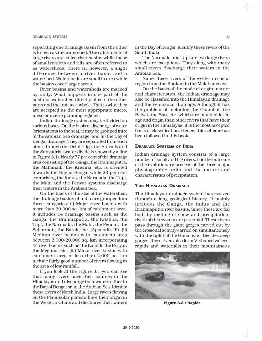
The Himalayan drainage system has evolvedthrough a long geological history. It mainlyincludes the Ganga, the Indus and theBrahmaputra river basins. Since these are fedboth by melting of snow and precipitation,rivers of this system are perennial. These riverspass through the giant gorges carved out bythe erosional activity carried on simultaneouslywith the uplift of the Himalayas. Besides deepgorges, these rivers also form V-shaped valleys,rapids and waterfalls in their mountainous
Figure 3.3 : Rapids
2019-2020
24 INDIA : PHYSICAL ENVIRONMENT
course. While entering the plains, they formdepositional features like flat valleys, ox-bowlakes, flood plains, braided channels, anddeltas near the river mouth. In the Himalayanreaches, the course of these rivers is highlytortous, but over the plains they display astrong meandering tendency and shift theircourses frequently. River Kosi, also know asthe ‘sorrow of Bihar’, has been notorious forfrequently changing its course. The Kosi bringshuge quantity of sediments from its upperreaches and deposits it in the plains. Thecourse gets blocked, and consequently, theriver changes its course. Why does the Kosiriver bring such huge quantity of sedimentsfrom the upper reaches? Do you think thatthe discharge of the water in the rivers ingeneral and the Kosi in particular, remains thesame, or does it fluctuate? When does the rivercourse receive the maximum quantity of water?What are the positive and negative effects offlooding?
EVOLUTION OF THE HIMALAYAN DRAINAGE
There are difference of opinion about the
evolution of the Himalayan rivers. However,geologists believe that a mighty river calledShiwalik or Indo-Brahma traversed the entire
longitudinal extent of the Himalaya from Assamto Punjab and onwards to Sind, and finallydischarged into the Gulf of Sind near lower
Punjab during the Miocene period some 5-24million years ago (See the table of geologicaltimes scale in Chapter 2 of Fundamentals of
Physical Geography, NCERT, 2006). Theremarkable continuity of the Shiwalik and itslacustrine origin and alluvial deposits
consisting of sands, silt, clay, boulders andconglomerates support this viewpoint.
It is opined that in due course of time Indo–Brahma river was dismembered into three maindrainage systems: (i) the Indus and its fivetributaries in the western part; (ii) the Gangaand its Himalayan tributaries in the centralpart; and (iii) the stretch of the Brahmaputrain Assam and its Himalayan tributaries in theeastern part. The dismemberment wasprobably due to the Pleistocene upheaval inthe western Himalayas, including the uplift of
the Potwar Plateau (Delhi Ridge), which actedas the water divide between the Indus andGanga drainage systems. Likewise, the down-thrusting of the Malda gap area between theRajmahal hills and the Meghalaya plateauduring the mid-pleistocene period, diverted theGanga and the Brahmaputra systems to flowtowards the Bay of Bengal.
THE RIVER SYSTEMS OF THE
HIMALAYAN DRAINAGE
The Himalayan drainage consists of severalriver systems but the following are the majorriver systems:
The Indus System
It is one of the largest river basins of the world,covering an area of 11,65,000 sq. km (in Indiait is 321, 289 sq. km and a total length of 2,880km (in India 1,114 km). The Indus alsoknown as the Sindhu, is the westernmost ofthe Himalayan rivers in India. It originatesfrom a glacier near Bokhar Chu (31°15' Nlatitude and 81°40' E longitude) in theTibetan region at an altitude of 4,164 m inthe Kailash Mountain range. In Tibet, it isknown as ‘Singi Khamban; or Lion’s mouth.After flowing in the northwest directionbetween the Ladakh and Zaskar ranges, itpasses through Ladakh and Baltistan. It cutsacross the Ladakh range, forming aspectacular gorge near Gilgit in Jammu andKashmir. It enters into Pakistan near Chilasin the Dardistan region. Find out the areaknown as Dardistan.
The Indus receives a number of Himalayantributaries such as the Shyok, the Gilgit, theZaskar, the Hunza, the Nubra, the Shigar, theGasting and the Dras. It finally emerges out ofthe hills near Attock where it receives the Kabulriver on its right bank. The other importanttributaries joining the right bank of the Indusare the Khurram, the Tochi, the Gomal, theViboa and the Sangar. They all originate in theSulaiman ranges. The river flows southwardand receives ‘Panjnad’ a little above Mithankot.The Panjnad is the name given to the five riversof Punjab, namely the Satluj, the Beas, the Ravi,the Chenab and the Jhelum. It finally discharges
2019-2020
25DRAINAGE SYSTEM
into the Arabian Sea, east of Karachi. The
Indus flows in India only through Jammu and
Kashmir.
The Jhelum, an important tributary of the
Indus, rises from a spring at Verinag situated
at the foot of the Pir Panjal in the south-eastern
part of the valley of Kashmir. It flows through
Srinagar and the Wular lake before entering
Pakistan through a deep narrow gorge. It joins
the Chenab near Jhang in Pakistan.
The Chenab is the largest tributary of the
Indus. It is formed by two streams, the
Chandra and the Bhaga, which join at
Tandi near Keylong in Himachal Pradesh.
Hence, it is also known as Chandrabhaga.
The river flows for 1,180 km before entering
into Pakistan.
The Ravi is another important tributary of
the Indus. It rises west of the Rohtang pass in
the Kullu hills of Himachal Pradesh and flows
through the Chamba valley of the state. Before
entering Pakistan and joining the Chenab near
Sarai Sidhu, it drains the area lying between
the southeastern part of the Pir Panjal and the
Dhauladhar ranges.
The Beas is another important tributary of
the Indus, originating from the Beas Kund near
the Rohtang Pass at an elevation of 4,000 m
above the mean sea level. The river flows
through the Kullu valley and forms gorges at
Kati and Largi in the Dhaoladhar range. It
enters the Punjab plains where it meets the
Satluj near Harike.
The Satluj originates in the ‘Raksas tal’ near
Mansarovar at an altitude of 4,555 m in Tibet
where it is known as Langchen Khambab. It
flows almost parallel to the Indus for about 400
km before entering India, and comes out of a
gorge at Rupar. It passes through the Shipki
La on the Himalayan ranges and enters the
Punjab plains. It is an antecedent river. It is a
very important tributary as it feeds the canal
system of the Bhakra Nangal project.
The Ganga System
The Ganga is the most important river of
India both from the point of view of its basin
and cultural significance. It rises in the
Gangotri glacier near Gaumukh (3,900 m)
in the Uttarkashi district of Uttarakhand.
Here, it is known as the Bhagirathi. It cuts
through the Central and the Lesser
Himalayas in narrow gorges. At Devprayag,
the Bhagirathi meets the Alaknanda;
hereafter, it is known as the Ganga. The
Alaknanda has its source in the Satopanth
glacier above Badrinath. The Alaknanda
consists of the Dhauli and the Vishnu Ganga
which meet at Joshimath or Vishnu Prayag.
The other tributaries of Alaknanda such as
the Pindar joins it at Karna Prayag
while Mandakini or Kali Ganga meets it at
Rudra Prayag. The Ganga enters the plains
at Haridwar. From here, it flows first to
the south, then to the south-east and east
Do you Know?
‘Namami Gange Programme’, is an
Integrated Conservation Mission, approved
as “Flagship Programme” by the Union
Government in June 2014 with the twin
objectives of effective abatement of pollution,
conservation and rejuvenation of the
National River Ganga.
Main pillars of the Namami Gange
Programme are:
• Sewerage Treatment Infrastructure
• River-Front Development
• River-Surface Cleaning
• Bio-Diversity
• Afforestation
• Public Awareness
• Industrial Effluent Monitoring
• Ganga Gram
You may explore about this project at
http://nmcg.nic.in/NamamiGanga.aspx#
2019-2020
26 INDIA : PHYSICAL ENVIRONMENT
before splitting into two distributaries, namelythe Bhagirathi and the Padma. The river hasa length of 2,525 km. It is shared byUttarakhand (110 km) and Uttar Pradesh(1,450 km), Bihar (445 km) and West Bengal(520 km). The Ganga basin covers about 8.6lakh sq. km area in India alone. The Gangariver system is the largest in India having anumber of perennial and non-perennial riversoriginating in the Himalayas in the north andthe Peninsula in the south, respectively. TheSon is its major right bank tributary. Theimportant left bank tributaries are theRamganga, the Gomati, the Ghaghara, theGandak, the Kosi and the Mahananda. Theriver finally discharges itself into the Bay ofBengal near the Sagar Island.
The Yamuna, the western most and thelongest tributary of the Ganga, has its sourcein the Yamunotri glacier on the western slopesof Banderpunch range (6,316 km). It joins theGanga at Prayag (Allahabad). It is joined bythe Chambal, the Sind, the Betwa and the Kenon its right bank which originates from thePeninsular plateau while the Hindan, the Rind,the Sengar, the Varuna, etc. join it on its leftbank. Much of its water feeds the western andeastern Yamuna and the Agra canals forirrigation purposes.
Name the states which are drained bythe river Yamuna.
The Chambal rises near Mhow in theMalwa plateau of Madhya Pradesh and flowsnorthwards through a gorge up wards of Kotain Rajasthan, where the Gandhisagar dam hasbeen constructed. From Kota, it traverses downto Bundi, Sawai Madhopur and Dholpur, andfinally joins the Yamuna. The Chambal isfamous for its badland topography called theChambal ravines.
The Gandak comprises two streams,namely Kaligandak and Trishulganga. It risesin the Nepal Himalayas between the Dhaulagiriand Mount Everest and drains the central partof Nepal. It enters the Ganga plain inChamparan district of Bihar and joins theGanga at Sonpur near Patna.
The Ghaghara originates in the glaciers ofMapchachungo. After collecting the waters of
its tributaries – Tila, Seti and Beri, it comesout of the mountain, cutting a deep gorge atShishapani. The river Sarda (Kali or KaliGanga) joins it in the plain before it finally meetsthe Ganga at Chhapra.
The Kosi is an antecedent river with itssource to the north of Mount Everest in Tibet,where its main stream Arun rises. Aftercrossing the Central Himalayas in Nepal, it isjoined by the Son Kosi from the West and theTamur Kosi from the east. It forms Sapt Kosiafter uniting with the river Arun.
The Ramganga is comparatively a smallriver rising in the Garhwal hills near Gairsain.It changes its course to the southwest directionafter crossing the Shiwalik and enters into theplains of Uttar Pradesh near Najibabad. Finally,it joins the Ganga near Kannauj.
The Damodar occupies the eastern marginsof the Chotanagpur Plateau where it flowsthrough a rift valley and finally joins the Hugli.The Barakar is its main tributary. Once knownas the ‘sorrow of Bengal’, the Damodar hasbeen now tamed by the Damodar Valleycorporation, a multipurpose project.
The Sarda or Saryu river rises in the Milamglacier in the Nepal Himalayas where it isknown as the Goriganga. Along the Indo-Nepalborder, it is called Kali or Chauk, where it joinsthe Ghaghara.
The Mahananda is another importanttributary of the Ganga rising in the Darjilinghills. It joins the Ganga as its last left banktributary in West Bengal.
The Son is a large south bank tributary ofthe Ganga, originating in the Amarkantakplateau. After forming a series of waterfalls atthe edge of the plateau, it reaches Arrah, westof Patna, to join the Ganga.
The Brahmaputra System
The Brahmaputra, one of the largest riversof the world, has its origin in theChemayungdung glacier of the Kailash rangenear the Mansarovar lake. From here, ittraverses eastward longitudinally for adistance of nearly 1,200 km in a dry andflat region of southern Tibet, where it isknown as the Tsangpo, which means ‘the
2019-2020
27DRAINAGE SYSTEM
purifier.’ The Rango Tsangpo is the majorright bank tributary of this river in Tibet. Itemerges as a turbulent and dynamic riverafter carving out a deep gorge in the CentralHimalayas near Namcha Barwa (7,755 m).The river emerges from the foothills underthe name of Siang or Dihang. It enters Indiawest of Sadiya town in Arunachal Pradesh.Flowing southwest, it receives its main leftbank tributaries, viz., Dibang or Sikang andLohit; thereafter, it is known as theBrahmaputra. The Brahmaputra receives numeroustributaries in its 750 km long journey throughthe Assam valley. Its major left banktributaries are the Burhi Dihing and Dhansari(South) whereas the important right banktributaries are the Subansiri, Kameng, Manasand Sankosh. The Subansiri which has itsorigin in Tibet, is an antecedent river. TheBrahmaputra enters into Bangladesh nearDhubri and flows southward. In Bangladesh,the Tista joins it on its right bank from wherethe river is known as the Jamuna. It finallymerges with the river Padma, which falls in theBay of Bengal. The Brahmaputra is well-knownfor floods, channel shifting and bank erosion.This is due to the fact that most of its tributariesare large, and bring large quantity of sedimentsowing to heavy rainfall in its catchment area.
THE PENINSULAR DRAINAGE SYSTEM
The Peninsular drainage system is older thanthe Himalayan one. This is evident from thebroad, largely-graded shallow valleys, and thematurity of the rivers. The Western Ghatsrunning close to the western coast act as thewater divide between the major Peninsularrivers, discharging their water in the Bay ofBengal and as small rivulets joining theArabian Sea. Most of the major Peninsularrivers except Narmada and Tapi flow from westto east. The Chambal, the Sind, the Betwa, theKen, the Son, originating in the northern partof the Peninsula belong to the Ganga riversystem. The other major river systems of thePeninsular drainage are – the Mahanadi theGodavari, the Krishna and the Kaveri.Peninsular rivers are characterised by fixed
course, absence of meanders and non-perennial flow of water. The Narmada and theTapi which flow through the rift valley are,however, exceptions.
The Evolution of Peninsular DrainageSystem
Three major geological events in the distantpast have shaped the present drainagesystems of Peninsular India: (i) Subsidenceof the western flank of the Peninsula leadingto its submergence below the sea during theearly tertiary period. Generally, it hasdisturbed the symmetrical plan of the riveron either side of the original watershed.(ii) Upheaval of the Himalayas when thenorthern flank of the Peninsular block wassubjected to subsidence and the consequenttrough faulting. The Narmada and The Tapiflow in trough faults and fill the originalcracks with their detritus materials. Hence,there is a lack of alluvial and deltaic depositsin these rivers. (iii) Slight tilting of thePeninsular block from northwest to thesoutheastern direction gave orientation to theentire drainage system towards the Bay ofBengal during the same period.
River Systems of the Peninsular Drainage
There are a large number of river systems inthe Peninsular drainage. A brief account of themajor Peninsular river systems is given below:
The Mahanadi rises near Sihawa in Raipurdistrict of Chhattisgarh and runs throughOdisha to discharge its water into the Bay ofBengal. It is 851 km long and its catchment areaspreads over 1.42 lakh sq. km. Somenavigation is carried on in the lower course ofthis river. Fifty three per cent of the drainagebasin of this river lies in Madhya Pradesh andChhattisgarh, while 47 per cent lies in Odisha.
The Godavari is the largest Peninsular riversystem. It is also called the Dakshin Ganga. Itrises in the Nasik district of Maharashtra anddischarges its water into the Bay of Bengal. Itstributaries run through the states ofMaharashtra, Madhya Pradesh, Chhattisgarh,Odisha and Andhra Pradesh. It is 1,465 kmlong with a catchment area spreading over 3.13
2019-2020
28 INDIA : PHYSICAL ENVIRONMENT
The Tapi is the other important westwardflowing river. It originates from Multai in the Betuldistrict of Madhya Pradesh. It is 724 km longand drains an area of 65,145 sq. km. Nearly 79per cent of its basin lies in Maharashtra, 15 percent in Madhya Pradesh and the remaining6 per cent in Gujarat.
Luni is the largest river system ofRajasthan, west of Aravali. It originates nearPushkar in two branches, i.e. the Saraswatiand the Sabarmati, which join with each otherat Govindgarh. From here, the river comes outof Aravali and is known as Luni. It flowstowards the west till Telwara and then takes asouthwest direction to join the Rann ofKuchchh. The entire river system is ephemeral.
Smaller Rivers Flowing Towards the West
The rivers flowing towards the Arabian seahave short courses. Why do they have shortcourses? Find out the smaller rivers ofGujarat. The Shetruniji is one such riverwhich rises near Dalkahwa in Amreli district.The Bhadra originates near Aniali village inRajkot district. The Dhadhar rises nearGhantar village in Panchmahal district.Sabarmati and Mahi are the two famous riversof Gujarat.
Find out the places of confluence of theserivers. Find out some important westflowing rivers of Maharashtra.
The Vaitarna rises from the Trimbak hillsin Nasik district at an elevation of 670 m. TheKalinadi rises from Belgaum district and fallsin the Karwar Bay. The source of Bedti riverlies in Hubli Dharwar and traverses a courseof 161 km. The Sharavati is another importantriver in Karnataka flowing towards the west.The Sharavati originates in Shimoga districtof Karnataka and drains a catchment area of2,209 sq. km.
Find out the name of the river on whichthe Gersoppa (Jog) fall is found.
Goa has two important rivers which can bementioned here. One is Mandovi and the otheris Juari. You can locate them on the map.
lakh sq. km 49 per cent of this, lies inMaharashtra, 20 per cent in Madhya Pradeshand Chhattisgarh, and the rest in AndhraPradesh. The Penganga, the Indravati, thePranhita, and the Manjra are its principaltributaries. The Godavari is subjected to heavyfloods in its lower reaches to the south ofPolavaram, where it forms a picturesque gorge.It is navigable only in the deltaic stretch. Theriver after Rajamundri splits into severalbranches forming a large delta.
The Krishna is the second largest east-flowing Peninsular river which rises nearMahabaleshwar in Sahyadri. Its total length is1,401 km. The Koyna, the Tungbhadra andthe Bhima are its major tributaries. Of the totalcatchment area of the Krishna, 27 per cent liesin Maharashtra, 44 per cent in Karnataka and29 per cent in Andhra Pradesh and Telangana.
The Kaveri rises in Brahmagiri hills(1,341m) of Kogadu district in Karnataka. Itslength is 800 km and it drains an area of81,155 sq. km. Since the upper catchmentarea receives rainfall during the southwestmonsoon season (summer) and the lower partduring the northeast monsoon season (winter),the river carries water throughout the year withcomparatively less fluctuation than the otherPeninsular rivers. About 3 per cent of the Kaveribasin falls in Kerala, 41 per cent in Karnatakaand 56 per cent in Tamil Nadu. Its importanttributaries are the Kabini, the Bhavani and theAmravati.
The Narmada originates on the western flankof the Amarkantak plateau at a height of about1,057 m. Flowing in a rift valley between theSatpura in the south and the Vindhyan rangein the north, it forms a picturesque gorge inmarble rocks and Dhuandhar waterfall nearJabalpur. After flowing a distance of about1,312 km, it meets the Arabian sea south ofBharuch, forming a broad 27 km long estuary.Its catchment area is about 98,796 sq. km. TheSardar Sarovar Project has been constructedon this river.
Collect information about Narmadariver conservation mission named“Namami Devi Narmade” and discusswith your peers.
2019-2020
29DRAINAGE SYSTEM
Kerala has a narrow coastline. The longestriver of Kerala, Bharathapuzha rises nearAnnamalai hills. It is also known as Ponnani.It drains an area of 5,397 sq. km. Compare itscatchment area with that of the Sharavati riverof Karnataka.
The Periyar is the second largest river ofKerala. Its catchment area is 5,243 sq. km.You can see that there is a marginal differencein the catchment area of the Bhartapuzha andthe Periyar rivers.
Another river of Kerala worth mentioning isthe Pamba river which falls in the Vemobanadlake after traversing a course of 177 km.
Teachers may explain the comparativeimportance of west flowing small rivers
River Catchment area
sq. km
Sabarmati 21,674Mahi 34,842Dhandhar 2,770Kalinadi 5,179Sharavati 2,029Bharathapuzha 5,397
Periyar 5,243
Small Rivers Flowing towards the East
There are a large number of rivers flowingtowards the east along with their tributaries.Can you name some of these rivers? There aresmall rivers which join the Bay of Bengal,though small, these are important in their own
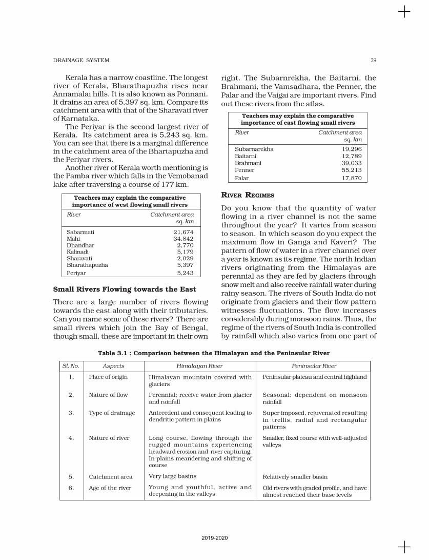
right. The Subarnrekha, the Baitarni, theBrahmani, the Vamsadhara, the Penner, thePalar and the Vaigai are important rivers. Findout these rivers from the atlas.
Teachers may explain the comparativeimportance of east flowing small rivers
River Catchment area
sq. km
Subarnarekha 19,296Baitarni 12,789Brahmani 39,033Penner 55,213
Palar 17,870
RIVER REGIMES
Do you know that the quantity of waterflowing in a river channel is not the samethroughout the year? It varies from seasonto season. In which season do you expect themaximum flow in Ganga and Kaveri? Thepattern of flow of water in a river channel overa year is known as its regime. The north Indianrivers originating from the Himalayas areperennial as they are fed by glaciers throughsnow melt and also receive rainfall water duringrainy season. The rivers of South India do notoriginate from glaciers and their flow patternwitnesses fluctuations. The flow increasesconsiderably during monsoon rains. Thus, theregime of the rivers of South India is controlledby rainfall which also varies from one part of
Table 3.1 : Comparison between the Himalayan and the Peninsular River
Sl. No. Aspects Himalayan River Peninsular River
1. Place of origin Peninsular plateau and central highland
2. Nature of flow Seasonal; dependent on monsoonrainfall
3. Type of drainage Super imposed, rejuvenated resultingin trellis, radial and rectangularpatterns
4. Nature of river Smaller, fixed course with well-adjustedvalleys
5. Catchment area Relatively smaller basin
6. Age of the river Old rivers with graded profile, and havealmost reached their base levels
Himalayan mountain covered withglaciers
Perennial; receive water from glacierand rainfall
Antecedent and consequent leading todendritic pattern in plains
Long course, flowing through therugged mountains experiencingheadward erosion and river capturing;In plains meandering and shifting ofcourse
Very large basins
Young and youthful, active anddeepening in the valleys
2019-2020
30 INDIA : PHYSICAL ENVIRONMENT
the Peninsular plateau to the other.The discharge is the volume of water flowing
in a river measured over time. It is measuredeither in cusecs (cubic feet per second) orcumecs (cubic metres per second).
The Ganga has its minimum flow duringthe January-June period. The maximum flowis attained either in August or in September.After September, there is a steady fall in theflow. The river, thus, has a monsoon regimeduring the rainy season.
There are striking differences in the riverregimes in the eastern and the western parts
of the Ganga Basin. The Ganga maintains asizeable flow in the early part of summer dueto snow melt before the monsoon rains begin.
The mean maximum discharge of the Gangaat Farakka is about 55,000 cusecs while themean minimum is only 1,300 cusecs. What
factors are responsible for such a largedifference?
The two Peninsular rivers displayinteresting differences in their regimescompared to the Himalayan rivers. TheNarmada has a very low volume of dischargefrom January to July but it suddenly rises inAugust when the maximum flow is attained.The fall in October is as spectacular as the risein August. The flow of water in the Narmada,as recorded at Garudeshwar, shows that themaximum flow is of the order of 2,300 cusecs,while the minimum flow is only 15 cusecs. TheGodavari has the minimum discharge in May,and the maximum in July-August. AfterAugust, there is a sharp fall in water flowalthough the volume of flow in October andNovember is higher than that in any of themonths from January to May. The meanmaximum discharge of the Godavari atPolavaram is 3,200 cusecs while the meanminimum flow is only 50 cusecs. These figuresgive an idea of the regime of the river.
EXTENT OF USABILITY OF RIVER WATER
The rivers of India carry huge volumes of waterper year but it is unevenly distributed both intime and space. There are perennial riverscarrying water throughout the year while thenon-perennial rivers have very little water during
the dry season. During the rainy season, muchof the water is wasted in floods and flows downto the sea. Similarly, when there is a flood in onepart of the country, the other area suffers fromdrought. Why does this happen? Is it theproblem of availability of water resource or thatof its management? Can you suggest somemeasures to mitigate the problems of floods anddroughts simultaneously occuring in differentparts of the country? (See Chapter 7 of the book).
Can these problems be solved or minimisedby trasfering the surplus water from one basinto the water deficit basins? Do we have someschemes of inter-basin linkage?
Teachers may explain the followingexamples
• Periyar Diversion Scheme• Indira Gandhi Canal Project• Kurnool-Cuddapah Canal• Beas-Satluj Link Canal• Ganga-Kaveri Link Canal
Have you read in the newspapers about thelinking of rivers? Do you think that digging acanal is enough to transfer water from the Gangabasin to the Peninsular river? What is the majorproblem? Consult Chapter 2 of this book andfind out the difficulties posed by theunevenness of the terrain. How can the waterbe lifted from the plain area to the plateau area?Is there sufficient surplus water in the northIndian rivers which can be transferred on aregular basis? Organise a debate on the wholeissue and prepare a write up. How do you rankthe following problems in using river water?
(i) No availability in sufficient quantity(ii) River water pollution(iii) Load of silt in the river water(iv) Uneven seasonal flow of water(v) River water disputes between states(vi) Shrinking of channels due to the extension
of settlements towards the thalweg.
Why are the rivers polluted? Have you seenthe dirty waters of cities entering into therivers? Where do the industrial affluents andwastes get disposed of ? Most of the cremationgrounds are on the banks of rivers and thedead bodies are sometimes thrown in the
2019-2020

31DRAINAGE SYSTEM
1. Choose the right answer from the four alternatives given below.
(i) Which one of the following rivers was known as the ‘Sorrow of Bengal’?
(a) The Gandak (c) The Kosi
(b) The Son (d) The Damodar
(ii) Which one of the following rivers has the largest river basin in India?
(a) The Indus (c) The Ganga
(b) The Brahmaputra (d) The Krishna
(iii) Which one of the following rivers is not included in ‘Panchnad’?
(a) The Ravi (c) The Indus
(b) The Chenab (d) The Jhelum
(iv) Which one of the following rivers flows in a rift valley?
(a) The Son (c) The Yamuna(b) The Narmada (d) The Luni
(v) Which one of the following is the place of confluence of the Alaknanda and theBhagirathi?
(a) Vishnu Prayag (c) Karan Prayag
(b) Rudra Prayag (d) Deva Prayag
2. State the differences between the following.
(i) River Basin and Watershed
(ii) Dendritic and Trellis drainage pattern
(iii) Radial and Centripetal drainage pattern
(iv) Delta and Estuary
3. Answer the following questions in about 30 words.
(i) What are the socio-economic advantages of inter-linking of rivers in India?
(ii) Write three characterstics of the Peninsular river.
4. Answer the following questions in not more than 125 words.
(i) What are the important characteristic features of north Indian rivers? How arethese different from Peninsular rivers?
(ii) Suppose you are travelling from Haridwar to Siliguri along the foothills of theHimalayas. Name the important rivers you will come across. Describe thecharacteristics of any one of them.
Project/Activity
Study the Appendix III and answer the following questions.
(i) Which river has the largest proportion of catchment area in the country?
(ii) Make a comparative bar diagram on a graph paper to show the length of thecourses of the rivers.
EXERCISES
rivers. On the occasion of some festivals, theflowers and statues are immersed in the rivers.Large scale bathing and washing of clothesalso pollute river waters. How can the riversbe made pollution free? Have you read about
Ganga Action Plan, or about a campaign forcleaning the Yamuna at Delhi? Collectmaterials on schemes for making riverspollution free and organise the materials in awrite up.
2019-2020

32 INDIA : PHYSICAL ENVIRONMENT
CLIMATE, VEGETATION AND SOIL
This unit deals with
• Weather and climate – spatial and temporal distribution of temperature,
pressure, winds and rainfall; Indian monsoons: mechanism, onset and
variability – spatial and temporal; climatic types
• Natural vegetation – forest types and distribution; wild life
conservation; biosphere reserves
• Soils – major types and their distribution, soil degradation and
conservation
UNIT
III
2019-2020

33CLIMATE
We drink more water during summers.Your uniform during the summer isdifferent from the winters. Why do
you wear lighter clothes during summers and
heavy woollen clothes during winters in north
India? In southern India, woollen clothes are
not required. In northeastern states, winters
are mild except in the hills. There are variations
in weather conditions during different seasons.
These changes occur due to the changes in the
elements of weather (temperature, pressure,
wind direction and velocity, humidity and
precipitation, etc.).
Weather is the momentary state of the
atmosphere while climate refers to the
average of the weather conditions over a
longer period of time. Weather changes
quickly, may be within a day or week but
climate changes imperceptively and may
be noted after 50 years or even more.
You have already studied about the
monsoon in your earlier classes. You are also
aware of the meaning of the word, “monsoon”.
Monsoon connotes the climate associated with
seasonal reversal in the direction of winds.
India has hot monsoonal climate which is the
prevalent climate in south and southeast Asia.
UNITY AND DIVERSITY IN THE MONSOON CLIMATE
The monsoon regime emphasises the unity of
India with the rest of southeast Asian region.
This view of broad unity of the monsoon type
of climate should not, however, lead one to
ignore its regional variations which differentiate
the weather and climate of different regions ofIndia. For example, the climate of Kerala and
Tamil Nadu in the south are so different from
that of Uttar Pradesh and Bihar in the north,
and yet all of these have a monsoon type ofclimate. The climate of India has many regional
variations expressed in the pattern of winds,
temperature and rainfall, rhythm of seasons
and the degree of wetness or dryness. Theseregional diversities may be described as
sub-types of monsoon climate. Let us take a
closer look at these regional variations in
temperature, winds and rainfall.While in the summer the mercury
occasionally touches 55°C in the western
Rajasthan, it drops down to as low as minus
45°C in winter around Leh. Churu in Rajasthanmay record a temperature of 50°C or more on a
June day while the mercury hardly touches
19°C in Tawang (Arunachal Pradesh) on the
same day. On a December night, temperaturein Drass (Jammu and Kashmir) may drop down
to minus 45°C while Thiruvananthapuram or
Chennai on the same night records 20°C or
22°C. These examples confirm that there areseasonal variations in temperature from place
to place and from region to region in India. Not
only this, if we take only a single place and
record the temperature for just one day,variations are no less striking. In Kerala and in
the Andaman Islands, the difference between
day and night temperatures may be hardly
seven or eight degree Celsius. But in the Thardesert, if the day temperature is around 50°C,
at night, it may drop down considerably upto15°-20°C.
CLIMATE
C H A P T E R
2019-2020
34 INDIA : PHYSICAL ENVIRONMENT
Now, let us see the regional variations inprecipitation. While snowfall occurs in theHimalayas, it only rains over the rest of thecountry. Similarly, variations are noticeable notonly in the type of precipitation but also in itsamount. While Cherrapunji and Mawsynramin the Khasi Hills of Meghalaya receive rainfallover 1,080 cm in a year, Jaisalmer in Rajasthanrarely gets more than 9 cm of rainfall duringthe same period.
Tura situated in the Garo Hills ofMeghalaya may receive an amount of rainfallin a single day which is equal to 10 years ofrainfall at Jaisalmer. While the annualprecipitation is less than 10 cm in the north-west Himalayas and the western deserts, itexceeds 400 cm in Meghalaya.
The Ganga delta and the coastal plains ofOrissa are hit by strong rain-bearing stormsalmost every third or fifth day in July andAugust while the Coromandal coast, athousand km to the south, goes generally dryduring these months. Most parts of the countryget rainfall during June-September, but on thecoastal areas of Tamil Nadu, it rains in thebeginning of the winter season.
In spite of these differences and variations,the climate of India is monsoonal in rhythmand character.
FACTORS DETERMINING THE CLIMATE OF INDIA
India’s climate is controlled by a number offactors which can be broadly divided into twogroups — factors related to location and relief,and factors related to air pressure and winds.
Factors related to Location and Relief
Latitude : You already know the latitudinal andlongitudinal extent of the land of India. Youalso know that the Tropic of Cancer passesthrough the central part of India in east-westdirection. Thus, northern part of the India liesin sub-tropical and temperate zone and thepart lying south of the Tropic of Cancer falls inthe tropical zone. The tropical zone beingnearer to the equator, experiences hightemperatures throughout the year with smalldaily and annual range. Area north of the
Tropic of Cancer being away from the equator,
experiences extreme climate with high daily
and annual range of temperature.
The Himalayan Mountains : The lofty Himalayas
in the north along with its extensions act as an
effective climatic divide. The towering mountain
chain provides an invincible shield to protect
the subcontinent from the cold northern winds.
These cold and chilly winds originate near the
Arctic circle and blow across central and eastern
Asia. The Himalayas also trap the monsoon
winds, forcing them to shed their moisture
within the subcontinent.
Distribution of Land and Water : India is
flanked by the Indian Ocean on three sides in
the south and girdled by a high and
continuous mountain-wall in the north. As
compared to the landmass, water heats up or
cools down slowly. This differential heating of
land and sea creates different air pressure
zones in different seasons in and around the
Indian subcontinent. Difference in air pressure
causes reversal in the direction of monsoon
winds.
Distance from the Sea : With a long coastline,
large coastal areas have an equable climate.
Areas in the interior of India are far away from
the moderating influence of the sea. Such
areas have extremes of climate. That is why,
the people of Mumbai and the Konkan coast
have hardly any idea of extremes of
temperature and the seasonal rhythm of
weather. On the other hand, the seasonal
contrasts in weather at places in the interior of
the country such as Delhi, Kanpur and
Amritsar affect the entire sphere of life.
Altitude : Temperature decreases with height.
Due to thin air, places in the mountains are
cooler than places on the plains. For example,
Agra and Darjiling are located on the same
latitude, but temperature of January in Agra
is 16°C whereas it is only 4°C in Darjiling.
Relief : The physiography or relief of India also
affects the temperature, air pressure, direction
and speed of wind and the amount and
distribution of rainfall. The windward sides of
Western Ghats and Assam receive high rainfall
2019-2020
35CLIMATE
during June-September whereas the southern
plateau remains dry due to its leeward
situation along the Western Ghats.
Factors Related to Air Pressure and Wind
To understand the differences in local climatesof India, we need to understand themechanism of the following three factors:
(i) Distribution of air pressure and windson the surface of the earth.
(ii) Upper air circulation caused by factorscontrolling global weather and the inflowof different air masses and jet streams.
(iii) Inflow of western cyclones generallyknown as disturbances during the winterseason and tropical depressions duringthe south-west monsoon period intoIndia, creating weather conditionsfavourable to rainfall.
The mechanism of these three factors canbe understood with reference to winter andsummer seasons of the year separately.
Mechanism of Weather in the Winter Season
Surface Pressure and Winds : In wintermonths, the weather conditions over India aregenerally influenced by the distribution ofpressure in Central and Western Asia. A highpressure centre in the region lying to the northof the Himalayas develops during winter. Thiscentre of high pressure gives rise to the flow ofair at the low level from the north towards theIndian subcontinent, south of the mountainrange. The surface winds blowing out of the highpressure centre over Central Asia reach Indiain the form of a dry continental air mass. Thesecontinental winds come in contact with tradewinds over northwestern India. The position ofthis contact zone is not, however, stable.Occasionally, it may shift its position as far eastas the middle Ganga valley with the result thatthe whole of the northwestern and northernIndia up to the middle Ganga valley comesunder the influence of dry northwestern winds.
Jet Stream and Upper Air Circulation : Thepattern of air circulation discussed above iswitnessed only at the lower level of theatmosphere near the surface of the earth. Higher
up in the lower troposphere, about three kmabove the surface of the earth, a different patternof air circulation is observed. The variations inthe atmospheric pressure closer to the surfaceof the earth have no role to play in the making ofupper air circulation. All of Western and CentralAsia remains under the influence of westerlywinds along the altitude of 9-13 km from westto east. These winds blow across the Asiancontinent at latitudes north of the Himalayasroughly parallel to the Tibetan highlands(Figure 4.1). These are known as jet streams.Tibetan highlands act as a barrier in the path ofthese jet streams. As a result, jet streams getbifurcated. One of its branches blows to the northof the Tibetan highlands, while the southernbranch blows in an eastward direction, south ofthe Himalayas. It has its mean position at 25°Nin February at 200-300 mb level. It is believedthat this southern branch of the jet streamexercises an important influence on the winterweather in India.
Western Cyclonic Disturbance and Tropical
Cyclones : The western cyclonic disturbances
which enter the Indian subcontinent from the westand the northwest during the winter months,originate over the Mediterranean Sea and are
Figure 4.1 : Direction of Winds in India inWinter at the Height of 9-13 km
2019-2020
36 INDIA : PHYSICAL ENVIRONMENT
brought into India by the westerly jet stream. Anincrease in the prevailing night temperaturegenerally indicates an advance in the arrival of thesecyclones disturbances.
Tropical cyclones originate over the Bay ofBengal and the Indian ocean. These tropicalcyclones have very high wind velocity and heavyrainfall and hit the Tamil Nadu, Andhra Pradeshand Orissa coast. Most of these cyclones are verydestructive due to high wind velocity and torrentialrain that accompanies it. Have you seen theirmovement in the weather report in the television?
Mechanism of Weather in the Summer Season
Surface Pressure and Winds : As the summersets in and the sun shifts northwards, the windcirculation over the subcontinent undergoesa complete reversal at both, the lower as wellas the upper levels. By the middle of July, thelow pressure belt nearer the surface [termedas Inter Tropical Convergence Zone (ITCZ)]
shifts northwards, roughly parallel to theHimalayas between 20° N and 25° N. By thistime, the westerly jet stream withdraws fromthe Indian region. In fact, meteorologists havefound an interrelationship between thenorthward shift of the equatorial trough (ITCZ)and the withdrawal of the westerly jet streamfrom over the North Indian Plain. It is generallybelieved that there is a cause and effectrelationship between the two. The ITCZ beinga zone of low pressure, attracts inflow of windsfrom different directions. The maritime tropicalairmass (mT) from the southern hemisphere,after crossing the equator, rushes to the lowpressure area in the general southwesterlydirection. It is this moist air current which ispopularly known as the southwest monsoon.
Jet Streams and Upper Air Circulation : Thepattern of pressure and winds as mentionedabove is formed only at the level of thetroposphere. An easterly jet stream flows over
Figure 4.2 : Summer Monsoon Winds : Surface Circulation
2019-2020
37CLIMATE
the southern part of the Peninsula in June, andhas a maximum speed of 90 km per hour(Figure 4.3). In August, it is confined to 15oNlatitude, and in September up to 22o N latitudes.The easterlies normally do not extend to the northof 30o N latitude in the upper atmosphere.
Easterly Jet Stream and Tropical Cyclones : Theeasterly jet stream steers the tropicaldepressions into India. These depressions playa significant role in the distribution of monsoonrainfall over the Indian subcontinent. Thetracks of these depressions are the areas ofhighest rainfall in India. The frequency at whichthese depressions visit India, their directionand intensity, all go a long way in determiningthe rainfall pattern during the southwestmonsoon period.
Inter Tropical Convergence Zone (ITCZ)
The Inter Tropical Convergence Zone (ITCZ) is a low pressure zone located at the equatorwhere trade winds converge, and so, it is a zone where air tends to ascend. In July, theITCZ is located around 20°N-25°N latitudes (over the Gangetic plain), sometimes calledthe monsoon trough. This monsoon trough encourages the development of thermal lowover north and northwest India. Due to the shift of ITCZ, the trade winds of the southernhemisphere cross the equator between 40° and 60°E longitudes and start blowing fromsouthwest to northeast due to the Coriolis force. It becomes southwest monsoon. In winter,the ITCZ moves southward, and so the reversal of winds from northeast to south andsouthwest, takes place. They are called northeast monsoons.
THE NATURE OF INDIAN MONSOON
Monsoon is a familiar though a little knownclimatic phenomenon. Despite the observationsspread over centuries, the monsoon continuesto puzzle the scientists. Many attempts havebeen made to discover the exact nature andcausation of monsoon, but so far, no singletheory has been able to explain the monsoonfully. A real breakthrough has come recentlywhen it was studied at the global rather thanat regional level.
Systematic studies of the causes of rainfallin the South Asian region help to understandthe causes and salient features of the monsoon,particularly some of its important aspects,such as:
(i) The onset of the monsoon.(ii) Rain-bearing systems (e.g. tropical
cyclones) and the relationship betweentheir frequency and distribution ofmonsoon rainfall.
(iii) Break in the monsoon.
Onset of the Monsoon
Towards the end of the nineteenth century, itwas believed that the differential heating ofland and sea during the summer months isthe mechanism which sets the stage for themonsoon winds to drift towards thesubcontinent. During April and May when thesun shines vertically over the Tropic of Cancer,the large landmass in the north of Indian oceangets intensely heated. This causes theformation of an intense low pressure in thenorthwestern part of the subcontinent. Sincethe pressure in the Indian Ocean in the southof the landmass is high as water gets heated
Figure 4.3 : The Direction of Winds at 13 kmAltitude in Summer Season
2019-2020
38 INDIA : PHYSICAL ENVIRONMENT
The shift in the position of the ITCZ is alsorelated to the phenomenon of the withdrawalof the westerly jet stream from its position over
the north Indian plain, south of the Himalayas.The easterly jet stream sets in along 15°Nlatitude only after the western jet stream has
withdrawn itself from the region. This easterlyjet stream is held responsible for the burst ofthe monsoon in India.
Entry of Monsoon into India : The southwestmonsoon sets in over the Kerala coast by 1stJune and moves swiftly to reach Mumbai and
Kolkata between 10th and 13th June. By mid-July, southwest monsoon engulfs the entiresubcontinent (Figure 4.5)
Rain-bearing Systems and RainfallDistribution
There seem to be two rain-bearing systems inIndia. First originate in the Bay of Bengalcausing rainfall over the plains of north India.
Second is the Arabian Sea current of the south-west monsoon which brings rain to the westcoast of India. Much of the rainfall along the
Western Ghats is orographic as the moist air isobstructed and forced to rise along the Ghats.The intensity of rainfall over the west coast of
India is, however, related to two factors:(i) The offshore meteorological conditions.(ii) The position of the equatorial jet stream
along the eastern coast of Africa.
EI-Nino and the Indian Monsoon
EI-Nino is a complex weather system that appears once every three to seven years, bringingdrought, floods and other weather extremes to different parts of the world.
The system involves oceanic and atmospheric phenomena with the appearance of warmcurrents off the coast of Peru in the Eastern Pacific and affects weather in many places includingIndia. EI-Nino is merely an extension of the warm equatorial current which gets replaced temporarilyby cold Peruvian current or Humbolt current (locate these currents in your atlas). This current
increases the temperature of water on the Peruvian coast by 10°C. This results in:
(i) the distortion of equatorial atmospheric circulation;(ii) irregularities in the evaporation of sea water;(iii) reduction in the amount of planktons which further reduces the number of fish in the sea.
The word EI-Nino means ‘Child Christ’ because this current appears around Christmasin December. December is a summer month in Peru (Southern Hemisphere).
EI-Nino is used in India for forecasting long range monsoon rainfall. In 1990-91, therewas a wild EI-Nino event and the onset of southwest monsoon was delayed over most parts ofthe country ranging from five to twelve days.
Figure 4.4 : Onset of Monsoon
slowly, the low pressure cell attracts thesoutheast trades across the Equator. Theseconditions help in the northward shift in theposition of the ITCZ. The southwest monsoonmay thus, be seen as a continuation of thesoutheast trades deflected towards the Indiansubcontinent after crossing the Equator. Thesewinds cross the Equator between 40°E and60°E longitudes.
2019-2020
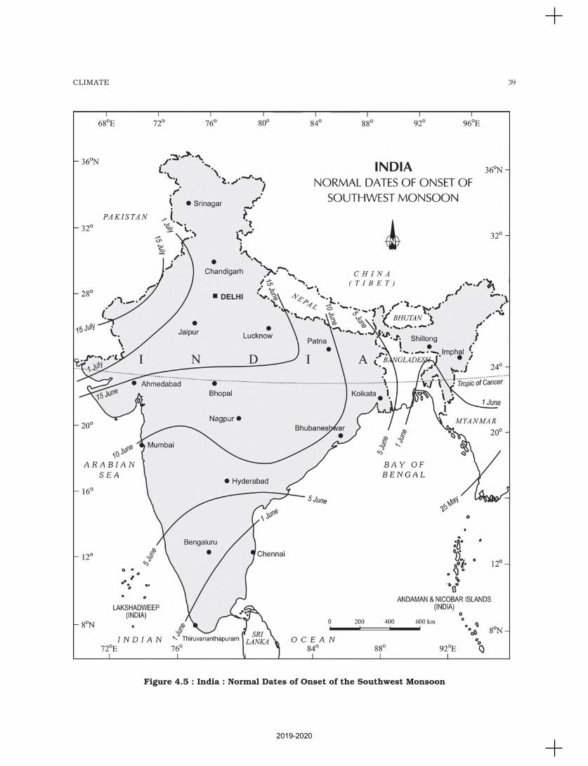
39CLIMATE
Figure 4.5 : India : Normal Dates of Onset of the Southwest Monsoon
2019-2020
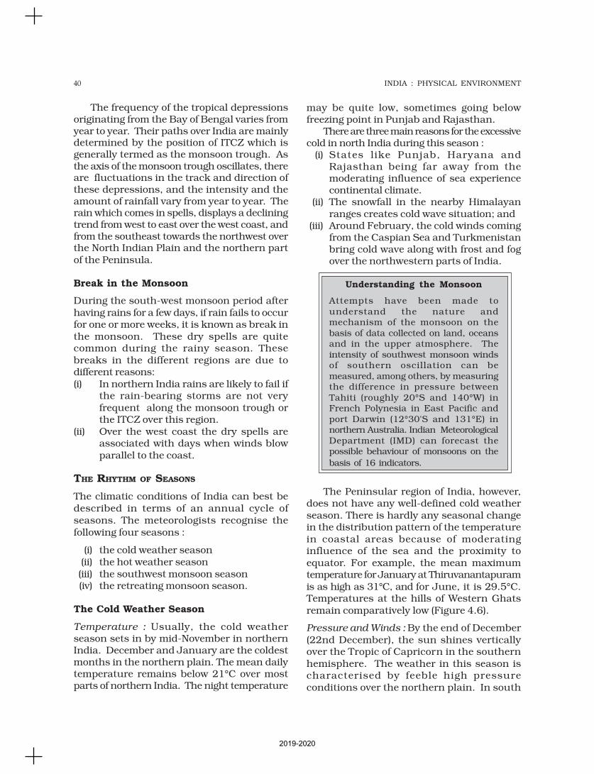
40 INDIA : PHYSICAL ENVIRONMENT
The frequency of the tropical depressionsoriginating from the Bay of Bengal varies fromyear to year. Their paths over India are mainlydetermined by the position of ITCZ which isgenerally termed as the monsoon trough. Asthe axis of the monsoon trough oscillates, thereare fluctuations in the track and direction ofthese depressions, and the intensity and theamount of rainfall vary from year to year. Therain which comes in spells, displays a decliningtrend from west to east over the west coast, andfrom the southeast towards the northwest overthe North Indian Plain and the northern partof the Peninsula.
Break in the Monsoon
During the south-west monsoon period afterhaving rains for a few days, if rain fails to occurfor one or more weeks, it is known as break inthe monsoon. These dry spells are quitecommon during the rainy season. Thesebreaks in the different regions are due todifferent reasons:(i) In northern India rains are likely to fail if
the rain-bearing storms are not veryfrequent along the monsoon trough orthe ITCZ over this region.
(ii) Over the west coast the dry spells areassociated with days when winds blowparallel to the coast.
THE RHYTHM OF SEASONS
The climatic conditions of India can best bedescribed in terms of an annual cycle ofseasons. The meteorologists recognise thefollowing four seasons :
(i) the cold weather season(ii) the hot weather season(iii) the southwest monsoon season(iv) the retreating monsoon season.
The Cold Weather Season
Temperature : Usually, the cold weatherseason sets in by mid-November in northernIndia. December and January are the coldestmonths in the northern plain. The mean dailytemperature remains below 21°C over mostparts of northern India. The night temperature
may be quite low, sometimes going belowfreezing point in Punjab and Rajasthan.
There are three main reasons for the excessivecold in north India during this season :
(i) States like Punjab, Haryana andRajasthan being far away from themoderating influence of sea experiencecontinental climate.
(ii) The snowfall in the nearby Himalayanranges creates cold wave situation; and
(iii) Around February, the cold winds comingfrom the Caspian Sea and Turkmenistanbring cold wave along with frost and fogover the northwestern parts of India.
Understanding the Monsoon
Attempts have been made tounderstand the nature andmechanism of the monsoon on thebasis of data collected on land, oceansand in the upper atmosphere. Theintensity of southwest monsoon windsof southern oscillation can bemeasured, among others, by measuringthe difference in pressure betweenTahiti (roughly 20°S and 140°W) inFrench Polynesia in East Pacific andport Darwin (12°30'S and 131°E) innorthern Australia. Indian MeteorologicalDepartment (IMD) can forecast thepossible behaviour of monsoons on the
basis of 16 indicators.
The Peninsular region of India, however,does not have any well-defined cold weatherseason. There is hardly any seasonal changein the distribution pattern of the temperaturein coastal areas because of moderatinginfluence of the sea and the proximity toequator. For example, the mean maximumtemperature for January at Thiruvanantapuramis as high as 31°C, and for June, it is 29.5°C.Temperatures at the hills of Western Ghatsremain comparatively low (Figure 4.6).
Pressure and Winds : By the end of December(22nd December), the sun shines verticallyover the Tropic of Capricorn in the southernhemisphere. The weather in this season ischaracterised by feeble high pressureconditions over the northern plain. In south
2019-2020
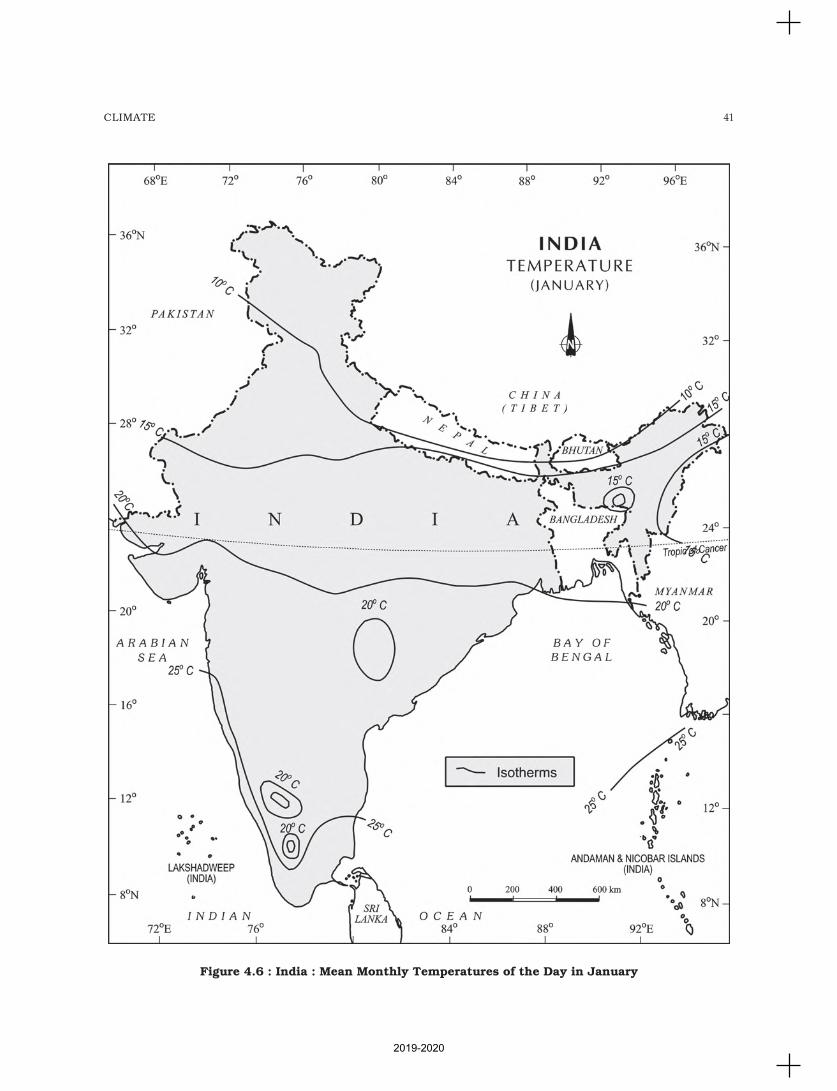
41CLIMATE
Figure 4.6 : India : Mean Monthly Temperatures of the Day in January
2019-2020
42 INDIA : PHYSICAL ENVIRONMENT
India, the air pressure is slightly lower. The
isobars of 1019 mb and 1013 mb pass
through northwest India and far south,
respectively (Figure 4.7).
As a result, winds start blowing from
northwestern high pressure zone to the low air
pressure zone over the Indian Ocean in the
south.
Due to low pressure gradient, the light
winds with a low velocity of about 3-5 km per
hour begin to blow outwards. By and large,
the topography of the region influences the
wind direction. They are westerly or
northwesterly down the Ganga Valley. They
become northerly in the Ganga-Brahmaputra
delta. Free from the influence of topography,
they are clearly northeasterly over the Bay of
Bengal.
During the winters, the weather in India
is pleasant. The pleasant weather conditions,
however, at intervals, get disturbed by shallow
cyclonic depressions originating over the east
Mediterranean Sea and travelling eastwards
across West Asia, Iran, Afghanistan and
Pakistan before they reach the northwestern
parts of India. On their way, the moisture
content gets augmented from the Caspian Sea
in the north and the Persian Gulf in the south.
What is the role of Westerly Jet Streams in
steering these depressions in India?
Rainfall : Winter monsoons do not cause
rainfall as they move from land to the sea. It is
because firstly, they have little humidity; and
secondly, due to anti cyclonic circulation on
land, the possibility of rainfall from them
reduces. So, most parts of India do not have
rainfall in the winter season. However, there are
some exceptions to it:
(i) In northwestern India, some weak
temperate cyclones from theMediterranean sea cause rainfall inPunjab, Haryana, Delhi and westernUttar Pradesh. Although the amountis meagre, it is highly beneficial forrabi crops. The precipitation is in thef o rm o f snow fa l l i n the l owerHimalayas. It is this snow thatsustains the flow of water in the
Himalayan rivers during the summer
months. The precipitation goes on
decreasing from west to east in the
plains and from north to south in the
mountains. The average winter rainfall
in Delhi is around 53 mm. In Punjab
and Bihar, rainfall remains between 25
mm and 18 mm respectively.
(ii) Central parts of India and northern
parts of southern Peninsula also get
winter rainfall occasionally.
(iii) Arunachal Pradesh and Assam in the
northeastern parts of India also have
rains between 25 mm and 50 mm
during these winter months.
(iv) During October and November,
northeast monsoon while crossing over
the Bay of Bengal, picks up moisture
and causes torrential rainfall over the
Tamil Nadu coast, southern Andhra
Pradesh, southeast Karnataka and
southeast Kerala.
The Hot Weather Season
Temperature: With the apparent northward
movement of the sun towards the Tropic of
Cancer in March, temperatures start rising
in north India. April, May and June are the
months of summer in north India. In most
parts of India, temperatures recorded are
between 30°-32°C. In March, the highest day
temperature of about 38°C occurs in the
Deccan Plateau while in April, temperature
ranging between 38°C and 43°C are found
in Gujarat and Madhya Pradesh. In May,
the heat belt moves further north, and in the
north-western part of India, temperatures
around 48°C are not uncommon (Figure 4.8).
The hot weather season in south India is
mild and not so intense as found in north
India. The Peninsular situation of south
India with moderating effect of the oceans
keeps the temperatures lower than that
prevailing in north India. So, temperatures
remain between 26°C and 32°C. Due to
altitude, the temperatures in the hills of
Western Ghats remain below 25°C. In the
coastal regions, the north-south extent of
2019-2020
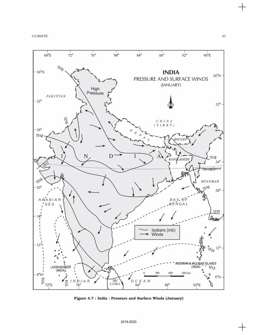
43CLIMATE
Figure 4.7 : India : Pressure and Surface Winds (January)
2019-2020
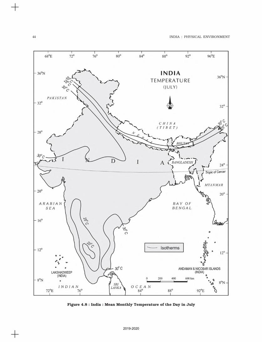
44 INDIA : PHYSICAL ENVIRONMENT
Figure 4.8 : India : Mean Monthly Temperature of the Day in July
2019-2020
45CLIMATE
isotherms parallel to the coast confirms that
temperature does not decrease from north
to south rather it increases from the coast
to the interior. The mean daily minimum
temperature during the summer months
also remains quite high and rarely goes
below 26°C.
Pressure and Winds : The summer months
are a period of excessive heat and falling air
pressure in the northern half of the country.
Because of the heating of the subcontinent,
the ITCZ moves northwards occupying a
position centred at 25°N in July. Roughly,
this elongated low pressure monsoon
trough extends over the Thar desert in the
north-west to Patna and Chotanagpur
plateau in the east-southeast (Figure 4.9).
The location of the ITCZ attracts a surface
circulation of the winds which are
southwesterly on the west coast as well as
along the coast of West Bengal and
Bangladesh. They are easterly or south-
easterly over north Bengal and Bihar. It has
been discussed earlier that these currents
of southwesterly monsoon are in reality
‘displaced’ equatorial westerlies. The influx
of these winds by mid-June brings about a
change in the weather towards the rainy
season.
In the heart of the ITCZ in the northwest,
the dry and hot winds known as ‘Loo’, blow
in the afternoon, and very often, they
continue to well into midnight. Dust storms
in the evening are very common during May
in Punjab, Haryana, Eastern Rajasthan and
Uttar Pradesh. These temporary storms
bring a welcome respite from the oppressing
heat since they bring with them light rains
and a pleasant cool breeze. Occasionally, the
moisture-laden winds are attracted towards
the periphery of the trough. A sudden
contact between dry and moist air masses
gives rise to local storms of great intensity.
These local storms are associated with
violent winds, torrential rains and even
hailstorms.
Some Famous Local Storms of HotWeather Season
(i) Mango Shower : Towards the end ofsummer, there are pre-monsoonshowers which are a commonphenomena in Kerala and coastalareas of Karnataka. Locally, theyare known as mango showers sincethey help in the early ripening ofmangoes.
(ii) Blossom Shower : With this shower,coffee flowers blossom in Kerala andnearby areas.
(iii) Nor Westers : These are dreadedevening thunderstorms in Bengaland Assam. Their notorious naturecan be understood from the localnomenclature of ‘Kalbaisakhi’, acalamity of the month of Baisakh.These showers are useful for tea,jute and rice cultivation. In Assam,these storms are known as “BardoliChheerha”.
(iv) Loo : Hot, dry and oppressing windsblowing in the Northern plains fromPunjab to Bihar with higher
intensity between Delhi and Patna.
THE SOUTHWEST MONSOON SEASON
As a result of rapid increase of temperature inMay over the northwestern plains, the lowpressure conditions over there get further
intensified. By early June, they are powerfulenough to attract the trade winds of SouthernHemisphere coming from the Indian Ocean.
These southeast trade winds cross the equatorand enter the Bay of Bengal and the ArabianSea, only to be caught up in the air circulation
over India. Passing over the equatorial warmcurrents, they bring with them moisture inabundance. After crossing the equator, they
follow a southwesterly direction. That is whythey are known as southwest monsoons.
The rain in the southwest monsoon season
begins rather abruptly. One result of the firstrain is that it brings down the temperaturesubstantially. This sudden onset of the
moisture-laden winds associated withviolent thunder and lightening, is oftentermed as the “break” or “burst” of the
2019-2020
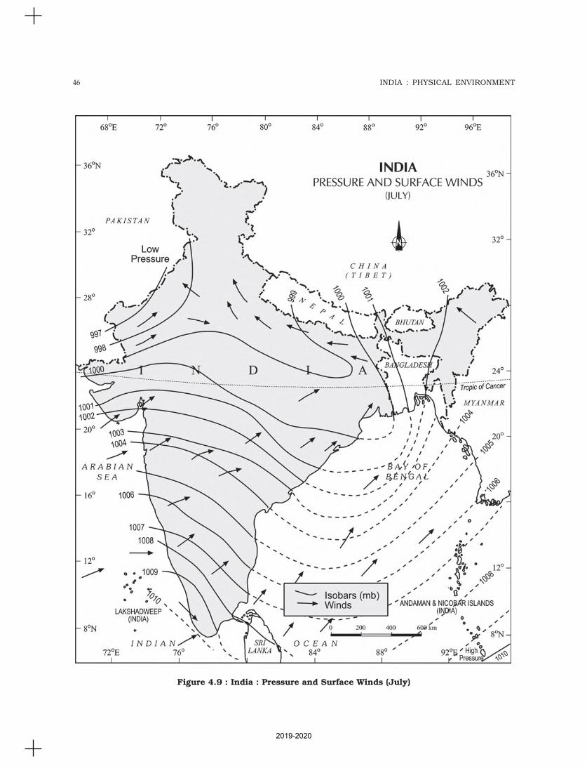
46 INDIA : PHYSICAL ENVIRONMENT
Figure 4.9 : India : Pressure and Surface Winds (July)
2019-2020
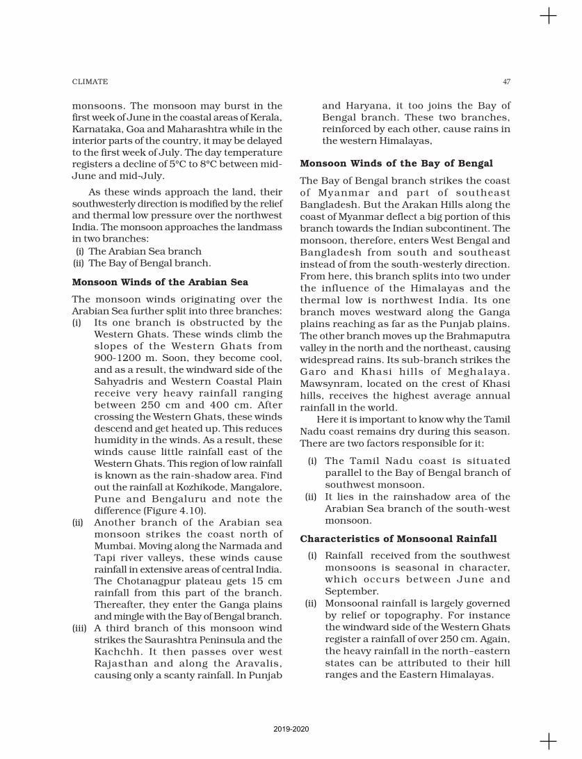
47CLIMATE
monsoons. The monsoon may burst in thefirst week of June in the coastal areas of Kerala,Karnataka, Goa and Maharashtra while in theinterior parts of the country, it may be delayedto the first week of July. The day temperatureregisters a decline of 5°C to 8°C between mid-June and mid-July.
As these winds approach the land, theirsouthwesterly direction is modified by the reliefand thermal low pressure over the northwestIndia. The monsoon approaches the landmassin two branches:
(i) The Arabian Sea branch(ii) The Bay of Bengal branch.
Monsoon Winds of the Arabian Sea
The monsoon winds originating over theArabian Sea further split into three branches:(i) Its one branch is obstructed by the
Western Ghats. These winds climb theslopes of the Western Ghats from900-1200 m. Soon, they become cool,and as a result, the windward side of theSahyadris and Western Coastal Plainreceive very heavy rainfall rangingbetween 250 cm and 400 cm. Aftercrossing the Western Ghats, these windsdescend and get heated up. This reduceshumidity in the winds. As a result, thesewinds cause little rainfall east of theWestern Ghats. This region of low rainfallis known as the rain-shadow area. Findout the rainfall at Kozhikode, Mangalore,Pune and Bengaluru and note thedifference (Figure 4.10).
(ii) Another branch of the Arabian seamonsoon strikes the coast north ofMumbai. Moving along the Narmada andTapi river valleys, these winds causerainfall in extensive areas of central India.The Chotanagpur plateau gets 15 cmrainfall from this part of the branch.Thereafter, they enter the Ganga plainsand mingle with the Bay of Bengal branch.
(iii) A third branch of this monsoon windstrikes the Saurashtra Peninsula and theKachchh. It then passes over westRajasthan and along the Aravalis,causing only a scanty rainfall. In Punjab
and Haryana, it too joins the Bay ofBengal branch. These two branches,reinforced by each other, cause rains inthe western Himalayas,
Monsoon Winds of the Bay of Bengal
The Bay of Bengal branch strikes the coast
of Myanmar and part of southeast
Bangladesh. But the Arakan Hills along the
coast of Myanmar deflect a big portion of thisbranch towards the Indian subcontinent. The
monsoon, therefore, enters West Bengal and
Bangladesh from south and southeast
instead of from the south-westerly direction.From here, this branch splits into two under
the influence of the Himalayas and the
thermal low is northwest India. Its one
branch moves westward along the Gangaplains reaching as far as the Punjab plains.
The other branch moves up the Brahmaputra
valley in the north and the northeast, causing
widespread rains. Its sub-branch strikes theGaro and Khasi hil ls of Meghalaya.
Mawsynram, located on the crest of Khasi
hills, receives the highest average annual
rainfall in the world.Here it is important to know why the Tamil
Nadu coast remains dry during this season.
There are two factors responsible for it:
(i) The Tamil Nadu coast is situatedparallel to the Bay of Bengal branch of
southwest monsoon.
(ii) It lies in the rainshadow area of the
Arabian Sea branch of the south-westmonsoon.
Characteristics of Monsoonal Rainfall
(i) Rainfall received from the southwest
monsoons is seasonal in character,which occurs between June and
September.
(ii) Monsoonal rainfall is largely governed
by relief or topography. For instancethe windward side of the Western Ghats
register a rainfall of over 250 cm. Again,
the heavy rainfall in the north-eastern
states can be attributed to their hillranges and the Eastern Himalayas.
2019-2020
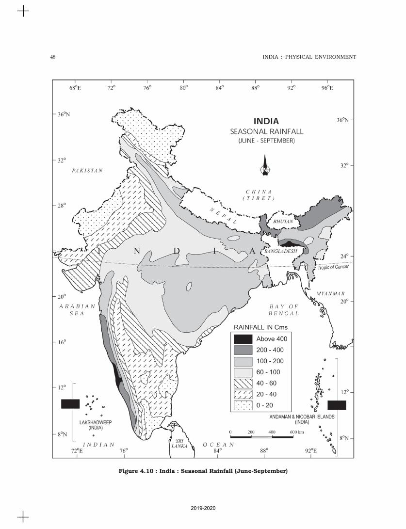
48 INDIA : PHYSICAL ENVIRONMENT
Figure 4.10 : India : Seasonal Rainfall (June-September)
2019-2020
49CLIMATE
(iii) The monsoon rainfall has a decliningtrend with increasing distance from thesea. Kolkata receives 119 cm duringthe southwest monsoon period, Patna105 cm, Allahabad 76 cm and Delhi56 cm.
(iv) The monsoon rains occur in wet spellsof few days duration at a time. The wetspells are interspersed with rainlessinterval known as ‘breaks’. These breaksin rainfall are related to the cyclonicdepressions mainly formed at the headof the Bay of Bengal, and their crossinginto the mainland. Besides the frequencyand intensity of these depressions, thepassage followed by them determinesthe spatial distribution of rainfall.
(v) The summer rainfall comes in a heavydownpour leading to considerable runoff and soil erosion.
(vi) Monsoons play a pivotal role in theagrarian economy of India because overthree-fourths of the total rain in thecountry is received during the south-west monsoon season.
(vii) Its spatial distribution is also unevenwhich ranges from 12 cm to more than250 cm.
(viii) The beginning of the rains sometimesis considerably delayed over the wholeor a part of the country.
(ix) The rains sometimes end considerablyearlier than usual, causing greatdamage to standing crops and makingthe sowing of winter crops difficult.
Season of Retreating Monsoon
The months of October and November areknown for retreating monsoons. By the endof September, the southwest monsoonbecomes weak as the low pressure trough ofthe Ganga plain starts moving southward inresponse to the southward march of the sun.The monsoon retreats from the westernRajasthan by the first week of September. Itwithdraws from Rajasthan, Gujarat, WesternGanga plain and the Central Highlands by theend of the month. By the beginning of October,the low pressure covers northern parts of theBay of Bengal and by early November, it moves
over Karnataka and Tamil Nadu. By themiddle of December, the centre of low pressureis completely removed from the Peninsula.
The retreating southwest monsoon seasonis marked by clear skies and rise intemperature. The land is still moist. Owing tothe conditions of high temperature andhumidity, the weather becomes ratheroppressive. This is commonly known as the‘October heat’. In the second half of October,the mercury begins to fall rapidly, particularlyin northern India. The weather in theretreating monsoon is dry in north India butit is associated with rain in the eastern part ofthe Peninsula. Here, October and Novemberare the rainiest months of the year.
The widespread rain in this season isassociated with the passage of cyclonicdepressions which originate over theAndaman Sea and manage to cross theeastern coast of the southern Peninsula. Thesetropical cyclones are very destructive. Thethickly populated deltas of the Godavari,Krishna and Kaveri are their preferred targets.Every year cyclones bring disaster here. A fewcyclonic storms also strike the coast of WestBengal, Bangladesh and Myanmar. A bulk ofthe rainfall of the Coromondal coast is derivedfrom these depressions and cyclones. Suchcyclonic storms are less frequent in theArabian Sea.
TRADITIONAL INDIAN SEASONS
In the Indian tradition, a year is divided intosix two-monthly seasons. This cycle of seasons,which the common people in north and centralIndia follow is based on their practicalexperience and age-old perception of weatherphenomena. However, this system does notmatch with the seasons of south India wherethere is little variation in the seasons.
Seasons Months Months
(According to the (According to the
Indian Calendar) Gregorian Calendar)
Vasanta Chaitra-Vaisakha March-April
Grishma Jyaistha-Asadha May-June
Varsha Sravana-Bhadra July-August
Sharada Asvina-Kartika September-October
Hemanta Margashirsa-Pausa November-December
Shishira Magha-Phalguna January-February
2019-2020

50 INDIA : PHYSICAL ENVIRONMENT
Distribution of Rainfall
The average annual rainfall in India is about125 cm, but it has great spatial variations(Figure 4.11).
Areas of High Rainfall : The highest rainfalloccurs along the west coast, on the WesternGhats, as well as in the sub-Himalayan areasis the northeast and the hills of Meghalaya. Herethe rainfall exceeds 200 cm. In some parts ofKhasi and Jaintia hills, the rainfall exceeds1,000 cm. In the Brahmaputra valley and theadjoining hills, the rainfall is less then 200 cm.
Areas of Medium Rainfall : Rainfall between100-200 cm is received in the southern partsof Gujarat, east Tamil Nadu, northeasternPeninsula covering Odisha, Jharkhand, Bihar,eastern Madhya Pradesh, northern Ganga plainalong the sub-Himalayas and the Cachar Valleyand Manipur.
Areas of Low Rainfall : Western Uttar Pradesh,Delhi, Haryana, Punjab, Jammu and Kashmir,eastern Rajasthan, Gujarat and Deccan Plateaureceive rainfall between 50-100 cm.
Areas of Inadequate Rainfall: Parts of thePeninsula, especially in Andhra Pradesh,Karnataka and Maharashtra, Ladakh and mostof western Rajasthan receive rainfall below 50 cm.
Snowfall is restricted to the Himalayanregion.
Identify the pattern of rainfall afterconsulting the rainfall map.
Variability of Rainfall
A characteristic feature of rainfall in India is itsvariability. The variability of rainfall is computedwith the help of the following formula:
C.V.Standard Deviation
Mean 100= ×
where C.V. is the coefficient of variation.The values of coefficient of variation show
the change from the mean values of rainfall. Theactual rainfall in some places deviates from20-50 per cent. The values of coefficient ofvariation show variability of rainfall in India. Avariability of less than 25 per cent exists on thewestern coasts, Western Ghats, northeastern
Peninsula, eastern plains of the Ganga, north-eastern India, Uttarakhand and HimachalPradesh and south-western part of Jammu andKashmir. These areas have an annual rainfallof over 100 cm. A variability of over 50 per centexists in the western part of Rajasthan, northernpart of Jammu and Kashmir and interior partsof the Deccan plateau. These areas have anannual rainfall of less than 50 cm. Rest of Indiahave a variability of 25-50 per cent and theseareas receive an annual rainfall between50 -100 cm (Figure 4.12).
Climatic Regions of India
The whole of India has a monsoon type ofclimate. But the combination of elements of theweather, however, reveal many regionalvariations. These variations represent the sub-types of the monsoon climate. It is on this basisthat the climatic regions can be identified. Aclimatic region has a homogeneous climaticcondition which is the result of a combinationof factors. Temperature and rainfall are twoimportant elements which are considered to bedecisive in all the schemes of climaticclassification. The classification of climate,however, is a complex exercise. There aredifferent schemes of classification of climate.Major climatic types of India based onKoeppen’s scheme have been described below:
Koeppen based his scheme of Climaticclassification on monthly values of temperatureand precipitation. He identified five majorclimatic types, namely:
(i) Tropical climates, where mean monthlytemperature throughout the year is over18°C.
(ii) Dry climates, where precipitation is verylow in comparison to temperature, andhence, dry. If dryness is less, it is semi-arid (S); if it is more, the climate is arid(W).
(iii) Warm temperate climates, where meantemperature of the coldest month isbetween 18°C and minus 3°C.
(iv) Cool temperate climates, where meantemperature of the warmest month is over10°C, and mean temperature of thecoldest month is under minus 3°C.
(v) Ice climates, where mean temperature ofthe warmest month is under 10°C.
2019-2020
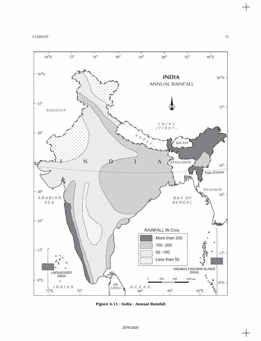
51CLIMATE
Figure 4.11 : India : Annual Rainfall
2019-2020
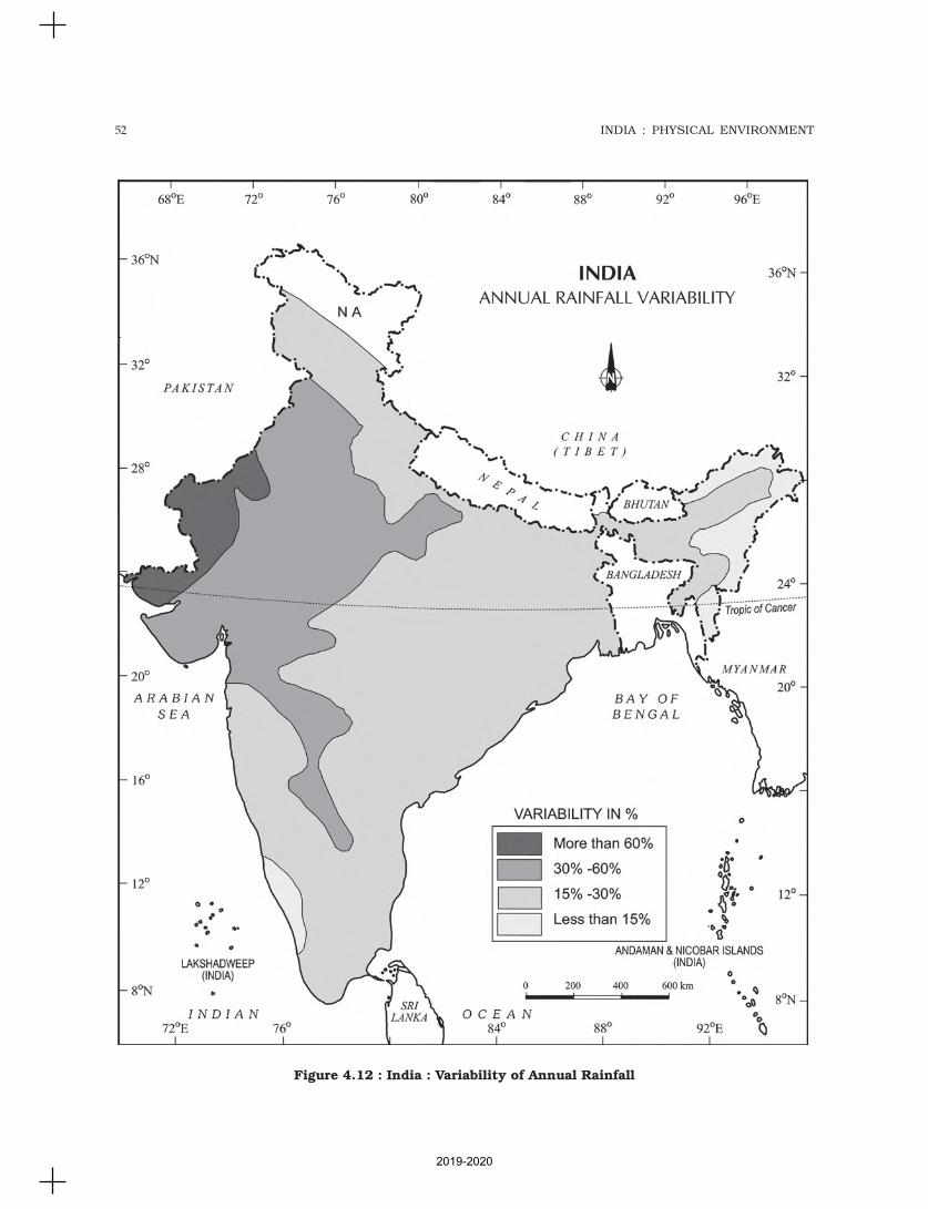
52 INDIA : PHYSICAL ENVIRONMENT
Figure 4.12 : India : Variability of Annual Rainfall
2019-2020
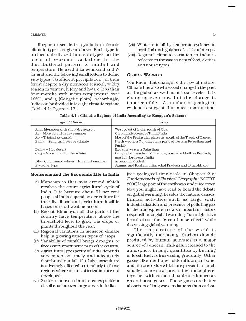
53CLIMATE
Koeppen used letter symbols to denoteclimatic types as given above. Each type isfurther sub-divided into sub-types on thebasis of seasonal variations in thedistributional pattern of rainfall andtemperature. He used S for semi-arid and Wfor arid and the following small letters to definesub-types: f (sufficient precipitation), m (rainforest despite a dry monsoon season), w (dryseason in winter), h (dry and hot), c (less thanfour months with mean temperature over10°C), and g (Gangetic plain). Accordingly,India can be divided into eight climatic regions(Table 4.1; Figure 4.13).
Monsoons and the Economic Life in India
(i) Monsoon is that axis around whichrevolves the entire agricultural cycle ofIndia. It is because about 64 per centpeople of India depend on agriculture fortheir livelihood and agriculture itself isbased on southwest monsoon.
(ii) Except Himalayas all the parts of thecountry have temperature above thethreashold level to grow the crops orplants throughout the year..
(iii) Regional variations in monsoon climatehelp in growing various types of crops.
(iv) Variability of rainfall brings droughts orfloods every year in some parts of the country.
(v) Agricultural prosperity of India dependsvery much on timely and adequatelydistributed rainfall. If it fails, agricultureis adversely affected particularly in thoseregions where means of irrigation are notdeveloped.
(vi) Sudden monsoon burst creates problemof soil erosion over large areas in India.
(vii) Winter rainfall by temperate cyclones in
north India is highly beneficial for rabi crops.
(viii) Regional climatic variation in India is
reflected in the vast variety of food, clothes
and house types.
GLOBAL WARMING
You know that change is the law of nature.
Climate has also witnessed change in the past
at the global as well as at local levels. It is
changing even now but the change is
imperceptible. A number of geological
evidences suggest that once upon a time,
(see geological time scale in Chapter 2 of
Fundamentals of Physical Geography, NCERT,
2006) large part of the earth was under ice cover.
Now you might have read or heard the debate
on global warming. Besides the natural causes,
human activities such as large scale
industrialisation and presence of polluting gas
in the atmosphere are also important factors
responsible for global warming. You might have
heard about the “green house effect” while
discussing global warming.
The temperature of the world is
significantly increasing. Carbon dioxide
produced by human activities is a major
source of concern. This gas, released to the
atmosphere in large quantities by burning
of fossil fuel, is increasing gradually. Other
gases like methane, chlorofluorocarbons,
and nitrous oxide which are present in much
smaller concentrations in the atmosphere,
together with carbon dioxide are known as
green house gases. These gases are better
absorbers of long wave radiations than carbon
Table 4.1 : Climatic Regions of India According to Koeppen’s Scheme
Type of Climate Areas
Amw Monsoon with short dry season West coast of India south of GoaAs – Monsoon with dry summer Coromandel coast of Tamil NaduAw – Tripical savannah Most of the Peninsular plateaus, south of the Tropic of CancerBwhw – Semi-arid steppe climate North-western Gujarat, some parts of western Rajasthan and
PunjabBwhw – Hot desert Extreme western RajasthanCwg – Monsoon with dry winter Ganga plain, eastern Rajasthan, northern Madhya Pradesh,
most of North-east IndiaDfc – Cold humid winter with short summer Arunachal PradeshE – Polar type Jammu and Kashmir, Himachal Pradesh and Uttarakhand
2019-2020
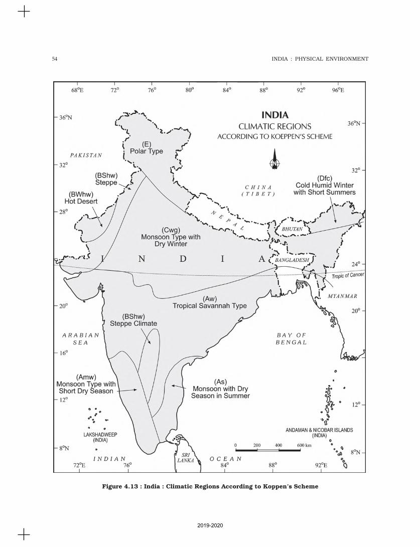
54 INDIA : PHYSICAL ENVIRONMENT
Figure 4.13 : India : Climatic Regions According to Koppen’s Scheme
2019-2020
55CLIMATE
dioxide, and so, are more effective at
enhancing the green house effect. Thesegases have been contributing to globalwarming. It is said that due to global warmingthe polar ice caps and mountain glacierswould melt and the amount of water in theoceans would increase.
The mean annual surface temperatureof the earth in the past 150 years hasincreased. It is projected that by the year2,100, global temperature will increase byabout 2°C. This rise in temperature willcause many other changes: one of these is arise in sea level, as a result of melting of
glaciers and sea-ice due to warming.According to the current prediction, on anaverage, the sea level will rise 48 cm by the
end of twenty first century. This wouldincrease the incidence of annual flooding.Climatic change would promote insect-
borne diseases like malaria, and lead to shiftin climatic boundaries, making someregions wetter and others drier. Agricultural
pattern would shift and human populationas well as the ecosystem would experiencechange. What would happen to the Indian
sea coasts if the sea level rises 50 cm abovethe present one?
1. Choose the right answer from the four alternatives given below.
(i) What causes rainfall on the coastal areas of Tamil Nadu in the beginningof winters?
(a) South-West monsoon (c) North-Eastern monsoon
(b) Temperate cyclones (d) Local air circulation
(ii) What is the proportion of area of India which receives annual rainfall lessthan 75 cm?
(a) Half (c) Two-third
(b) One-third (d) Three-fourth
(iii) Which one of the following is not a fact regarding South India?
(a) Diurnal range of temperature is less here.
(b) Annual range of temperature is less here.
(c) Temperatures here are high throughout the year.
(d) Extreme climatic conditions are found here.
(iv) Which one of the following phenomenon happens when the sun shinesvertically over the Tropic of Capricorn in the southern hemisphere?
(a) High pressure develops over North-western India due to lowtemperatures.
(b) Low pressure develops over North-western India due to hightemperatures.
(c) No changes in temperature and pressure occur in north-westernIndia.
(d) ‘Loo’ blows in the North-western India.
(v) In which of the following states in India do we find ‘As’ type of climate asper Koeppen’s classification?
(a) In Kerala and coastal Karnataka
(b) In Andaman and Nicobar Islands
(c) On Coromandel coast
(d) In Assam and Arunachal Pradesh
EXERCISES
2019-2020
56 INDIA : PHYSICAL ENVIRONMENT
2. Answer the following questions in about 30 words.
(i) What are the three important factors which influence the mechanism ofIndian weather?
(ii) What is the Inter-Tropical Convergene Zone?
(iii) What is meant by ‘bursting of monsoon’? Name the place of India whichgets the highest rainfall.
(iv) Define ‘climatic region’? What are the bases of Koeppen’s classification?
(v) Which type(s) of cyclones cause rainfall in north-western India duringwinter? Where do they originate?
3. Answer the following questions in not more than 125 words.
(i) Notwithstanding the broad climatic unity, the climate of India has manyregional variations. Elaborate this statement giving suitable examples.
(ii) How many distinct seasons are found in India as per the IndianMeteorological Department? Discuss the weather conditions associatedwith any one season in detail.
Project/Activity
On the outline map of India, show the following:
(i) Areas of winter rain
(ii) Wind direction during the summer season
(iii) Areas having variability of rainfall over 50 per cent
(iv) Areas having less than 15°C temperature in January
(v) Isohyte of 100 cm.
2019-2020
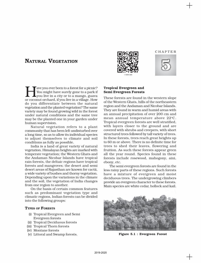
Have you ever been to a forest for a picnic?You might have surely gone to a park ifyou live in a city or to a mango, guava
or coconut orchard, if you live in a village. Howdo you differentiate between the naturalvegetation and the planted vegetation? The samevariety may be found growing wild in the forestunder natural conditions and the same treemay be the planted one in your garden underhuman supervision.
Natural vegetation refers to a plantcommunity that has been left undisturbed overa long time, so as to allow its individual speciesto adjust themselves to climate and soilconditions as fully as possible.
India is a land of great variety of naturalvegetation. Himalayan heights are marked withtemperate vegetation; the Western Ghats andthe Andaman Nicobar Islands have tropicalrain forests, the deltaic regions have tropicalforests and mangroves; the desert and semidesert areas of Rajasthan are known for cactii,a wide variety of bushes and thorny vegetation.Depending upon the variations in the climateand the soil, the vegetation of India changesfrom one region to another.
On the basis of certain common featuressuch as predominant vegetation type andclimatic regions, Indian forests can be dividedinto the following groups:
TYPES OF FORESTS
(i) Tropical Evergreen and SemiEvergreen forests
(ii) Tropical Deciduous forests(iii) Tropical Thorn forests(iv) Montane forests(v) Littoral and Swamp forests.
Tropical Evergreen andSemi Evergreen Forests
These forests are found in the western slopeof the Western Ghats, hills of the northeasternregion and the Andaman and Nicobar Islands.They are found in warm and humid areas withan annual precipitation of over 200 cm andmean annual temperature above 22oC.Tropical evergreen forests are well stratified,with layers closer to the ground and arecovered with shrubs and creepers, with shortstructured trees followed by tall variety of trees.In these forests, trees reach great heights upto 60 m or above. There is no definite time fortrees to shed their leaves, flowering andfruition. As such these forests appear greenall the year round. Species found in theseforests include rosewood, mahogony, aini,ebony, etc.
The semi evergreen forests are found in theless rainy parts of these regions. Such forestshave a mixture of evergreen and moistdeciduous trees. The undergrowing climbersprovide an evergreen character to these forests.Main species are white cedar, hollock and kail.
NATURAL VEGETATION
C H A P T E R
Figure 5.1 : Evergreen Forest
2019-2020

58 INDIA : PHYSICAL ENVIRONMENT
Figure 5.2 : Natural Vegetation
2019-2020
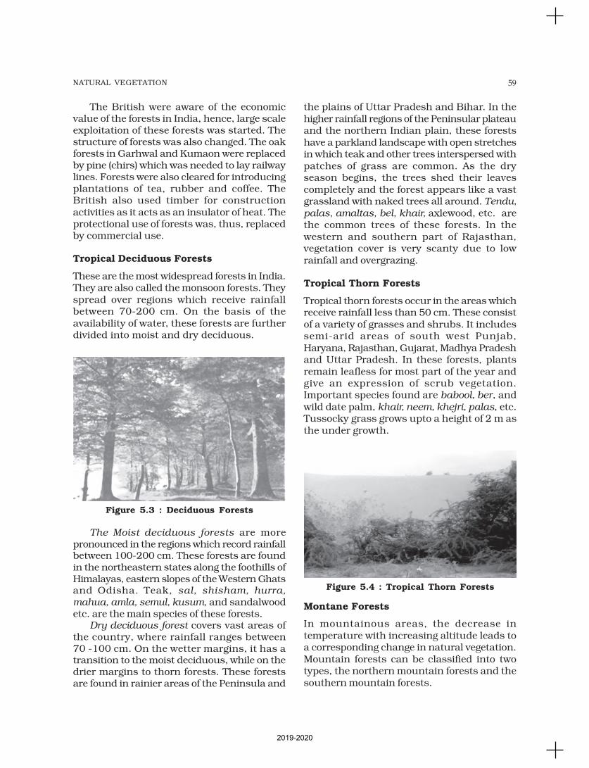
59NATURAL VEGETATION
The British were aware of the economicvalue of the forests in India, hence, large scaleexploitation of these forests was started. Thestructure of forests was also changed. The oakforests in Garhwal and Kumaon were replacedby pine (chirs) which was needed to lay railwaylines. Forests were also cleared for introducingplantations of tea, rubber and coffee. TheBritish also used timber for constructionactivities as it acts as an insulator of heat. Theprotectional use of forests was, thus, replacedby commercial use.
Tropical Deciduous Forests
These are the most widespread forests in India.They are also called the monsoon forests. Theyspread over regions which receive rainfallbetween 70-200 cm. On the basis of theavailability of water, these forests are furtherdivided into moist and dry deciduous.
The Moist deciduous forests are morepronounced in the regions which record rainfallbetween 100-200 cm. These forests are foundin the northeastern states along the foothills ofHimalayas, eastern slopes of the Western Ghatsand Odisha. Teak, sal, shisham, hurra,
mahua, amla, semul, kusum, and sandalwoodetc. are the main species of these forests.
Dry deciduous forest covers vast areas ofthe country, where rainfall ranges between70 -100 cm. On the wetter margins, it has atransition to the moist deciduous, while on thedrier margins to thorn forests. These forestsare found in rainier areas of the Peninsula and
the plains of Uttar Pradesh and Bihar. In thehigher rainfall regions of the Peninsular plateauand the northern Indian plain, these forestshave a parkland landscape with open stretchesin which teak and other trees interspersed withpatches of grass are common. As the dryseason begins, the trees shed their leavescompletely and the forest appears like a vastgrassland with naked trees all around. Tendu,
palas, amaltas, bel, khair, axlewood, etc. arethe common trees of these forests. In thewestern and southern part of Rajasthan,vegetation cover is very scanty due to lowrainfall and overgrazing.
Tropical Thorn Forests
Tropical thorn forests occur in the areas whichreceive rainfall less than 50 cm. These consistof a variety of grasses and shrubs. It includessemi-arid areas of south west Punjab,Haryana, Rajasthan, Gujarat, Madhya Pradeshand Uttar Pradesh. In these forests, plantsremain leafless for most part of the year andgive an expression of scrub vegetation.Important species found are babool, ber, andwild date palm, khair, neem, khejri, palas, etc.Tussocky grass grows upto a height of 2 m asthe under growth.
Montane Forests
In mountainous areas, the decrease intemperature with increasing altitude leads toa corresponding change in natural vegetation.Mountain forests can be classified into twotypes, the northern mountain forests and thesouthern mountain forests.
Figure 5.3 : Deciduous Forests
Figure 5.4 : Tropical Thorn Forests
2019-2020
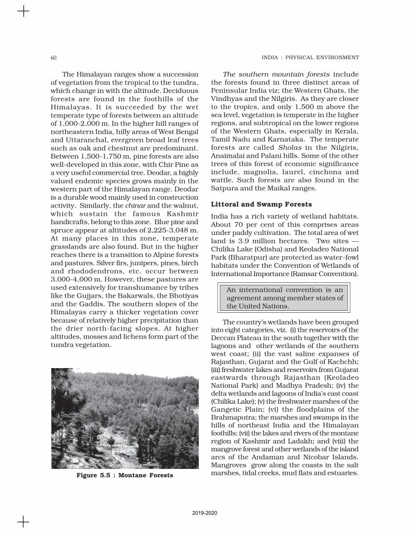
60 INDIA : PHYSICAL ENVIRONMENT
The Himalayan ranges show a successionof vegetation from the tropical to the tundra,which change in with the altitude. Deciduousforests are found in the foothills of theHimalayas. It is succeeded by the wettemperate type of forests between an altitudeof 1,000-2,000 m. In the higher hill ranges ofnortheastern India, hilly areas of West Bengaland Uttaranchal, evergreen broad leaf treessuch as oak and chestnut are predominant.Between 1,500-1,750 m, pine forests are alsowell-developed in this zone, with Chir Pine asa very useful commercial tree. Deodar, a highlyvalued endemic species grows mainly in thewestern part of the Himalayan range. Deodaris a durable wood mainly used in constructionactivity. Similarly, the chinar and the walnut,which sustain the famous Kashmirhandicrafts, belong to this zone. Blue pine andspruce appear at altitudes of 2,225-3,048 m.At many places in this zone, temperategrasslands are also found. But in the higherreaches there is a transition to Alpine forestsand pastures. Silver firs, junipers, pines, birchand rhododendrons, etc. occur between3,000-4,000 m. However, these pastures areused extensively for transhumance by tribeslike the Gujjars, the Bakarwals, the Bhotiyasand the Gaddis. The southern slopes of theHimalayas carry a thicker vegetation coverbecause of relatively higher precipitation thanthe drier north-facing slopes. At higheraltitudes, mosses and lichens form part of thetundra vegetation.
The southern mountain forests includethe forests found in three distinct areas ofPeninsular India viz; the Western Ghats, theVindhyas and the Nilgiris. As they are closerto the tropics, and only 1,500 m above thesea level, vegetation is temperate in the higherregions, and subtropical on the lower regionsof the Western Ghats, especially in Kerala,Tamil Nadu and Karnataka. The temperateforests are called Sholas in the Nilgiris,Anaimalai and Palani hills. Some of the othertrees of this forest of economic significanceinclude, magnolia, laurel, cinchona andwattle. Such forests are also found in theSatpura and the Maikal ranges.
Littoral and Swamp Forests
India has a rich variety of wetland habitats.About 70 per cent of this comprises areasunder paddy cultivation. The total area of wetland is 3.9 million hectares. Two sites —Chilika Lake (Odisha) and Keoladeo NationalPark (Bharatpur) are protected as water-fowlhabitats under the Convention of Wetlands ofInternational Importance (Ramsar Convention).
An international convention is anagreement among member states ofthe United Nations.
The country’s wetlands have been groupedinto eight categories, viz. (i) the reservoirs of theDeccan Plateau in the south together with thelagoons and other wetlands of the southernwest coast; (ii) the vast saline expanses ofRajasthan, Gujarat and the Gulf of Kachchh;(iii) freshwater lakes and reservoirs from Gujarateastwards through Rajasthan (KeoladeoNational Park) and Madhya Pradesh; (iv) thedelta wetlands and lagoons of India’s east coast(Chilika Lake); (v) the freshwater marshes of theGangetic Plain; (vi) the floodplains of theBrahmaputra; the marshes and swamps in thehills of northeast India and the Himalayanfoothills; (vii) the lakes and rivers of the montaneregion of Kashmir and Ladakh; and (viii) themangrove forest and other wetlands of the islandarcs of the Andaman and Nicobar Islands.Mangroves grow along the coasts in the saltmarshes, tidal creeks, mud flats and estuaries.Figure 5.5 : Montane Forests
2019-2020
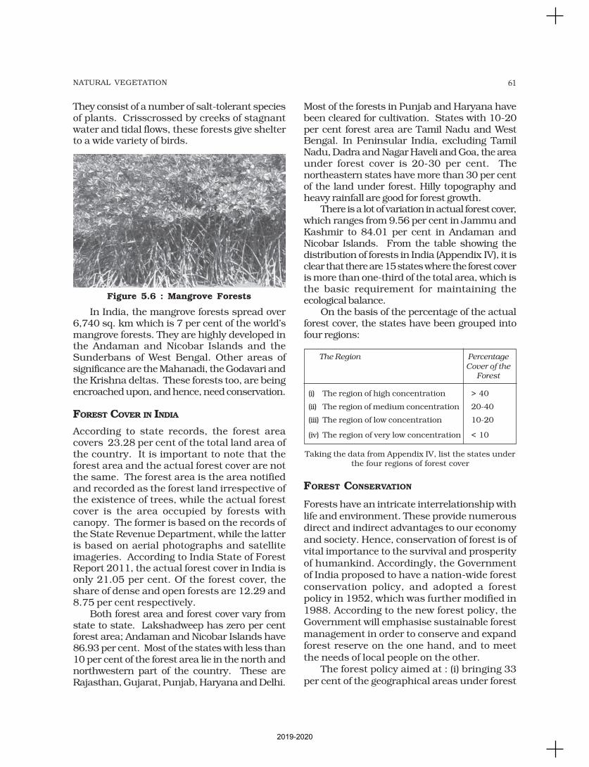
61NATURAL VEGETATION
They consist of a number of salt-tolerant speciesof plants. Crisscrossed by creeks of stagnantwater and tidal flows, these forests give shelterto a wide variety of birds.
In India, the mangrove forests spread over6,740 sq. km which is 7 per cent of the world’smangrove forests. They are highly developed inthe Andaman and Nicobar Islands and theSunderbans of West Bengal. Other areas ofsignificance are the Mahanadi, the Godavari andthe Krishna deltas. These forests too, are beingencroached upon, and hence, need conservation.
FOREST COVER IN INDIA
According to state records, the forest areacovers 23.28 per cent of the total land area ofthe country. It is important to note that theforest area and the actual forest cover are notthe same. The forest area is the area notifiedand recorded as the forest land irrespective ofthe existence of trees, while the actual forestcover is the area occupied by forests withcanopy. The former is based on the records ofthe State Revenue Department, while the latteris based on aerial photographs and satelliteimageries. According to India State of ForestReport 2011, the actual forest cover in India isonly 21.05 per cent. Of the forest cover, theshare of dense and open forests are 12.29 and8.75 per cent respectively.
Both forest area and forest cover vary fromstate to state. Lakshadweep has zero per centforest area; Andaman and Nicobar Islands have86.93 per cent. Most of the states with less than10 per cent of the forest area lie in the north andnorthwestern part of the country. These areRajasthan, Gujarat, Punjab, Haryana and Delhi.
Most of the forests in Punjab and Haryana havebeen cleared for cultivation. States with 10-20per cent forest area are Tamil Nadu and WestBengal. In Peninsular India, excluding TamilNadu, Dadra and Nagar Haveli and Goa, the areaunder forest cover is 20-30 per cent. Thenortheastern states have more than 30 per centof the land under forest. Hilly topography andheavy rainfall are good for forest growth.
There is a lot of variation in actual forest cover,which ranges from 9.56 per cent in Jammu andKashmir to 84.01 per cent in Andaman andNicobar Islands. From the table showing thedistribution of forests in India (Appendix IV), it isclear that there are 15 states where the forest coveris more than one-third of the total area, which isthe basic requirement for maintaining theecological balance.
On the basis of the percentage of the actualforest cover, the states have been grouped intofour regions:
The Region Percentage
Cover of the
Forest
(i) The region of high concentration > 40
(ii) The region of medium concentration 20-40
(iii) The region of low concentration 10-20
(iv) The region of very low concentration < 10
Taking the data from Appendix IV, list the states underthe four regions of forest cover
FOREST CONSERVATION
Forests have an intricate interrelationship withlife and environment. These provide numerousdirect and indirect advantages to our economyand society. Hence, conservation of forest is ofvital importance to the survival and prosperityof humankind. Accordingly, the Governmentof India proposed to have a nation-wide forestconservation policy, and adopted a forestpolicy in 1952, which was further modified in1988. According to the new forest policy, theGovernment will emphasise sustainable forestmanagement in order to conserve and expandforest reserve on the one hand, and to meetthe needs of local people on the other.
The forest policy aimed at : (i) bringing 33per cent of the geographical areas under forest
Figure 5.6 : Mangrove Forests
2019-2020
62 INDIA : PHYSICAL ENVIRONMENT
cover; (ii) maintaining environmental stabilityand to restore forests where ecological balancewas disturbed; (iii) conserving the naturalheritage of the country, its biological diversityand genetic pool; (iv) checks soil erosion,extension of the desert lands and reduction offloods and droughts; (v) increasing the forestcover through social forestry and afforestationon degraded land; (vi) increasing theproductivity of forests to make timber, fuel,fodder and food available to rural populationdependant on forests, and encourage thesubstitution of wood; (vii) creating of a massivepeoples movement involving women toencourage planting of trees, stop felling of treesand thus, reduce pressure on the existing forest.
Forests and Life
To a vast number of tribal people, the
forest is a home, a livelihood, theirvery existence. It provides them food,fruits of all kinds, edible leaves, honey,
nourishing roots and wild game. Itprovides them with material to buildtheir houses and items for practising
their arts. The importance of forestsin tribal economy is well-known asthey are the source of sustenance and
livelihood for tribal communities. It iscommonly believed that the tribalcommunities live in harmony with
nature and protect forests. Out of atotal of 593 districts 188 have beenidentified as tribal districts. The tribal
districts account for about 59.61 percent of the total forest cover of thecountry whereas the geographical
area of 188 tribal districts formsonly 33.63 per cent of the totalgeographical area of the country. It
demonstrates that tribal districts aregenerally rich in forest cover.
Forest and tribals are very closely
related. The age-old knowledge oftribals regarding forestry can be usedin the development of forests. Rather
than treating tribals as minor forestproduce collectors they should bemade growers of minor forest produce
and encouraged to participate in
conservation.
Based on the forest conservation policy thefollowing steps were initiated:
Social Forestry
Social forestry means the management and
protection of forests and afforestation on barren
lands with the purpose of helping in the
environmental, social and rural development.The National Commission on Agriculture
(1976) has classified social forestry into three
categories. These are Urban forestry, Rural
forestry and Farm forestry.Urban forestry pertains to the raising and
management of trees on public and privately
owned lands in and around urban centres
such as green belts, parks, roadside avenues,industrial and commercial green belts, etc.
Rural forestry lays emphasis on promotion
of agro-forestry and community-forestry.
Agro-forestry is the raising of trees andagriculture crops on the same land inclusive
of the waste patches. It combines forestry with
agriculture, thus, altering the simultaneous
production of food, fodder, fuel, timber andfruit. Community forestry involves the raising
of trees on public or community land such as
the village pasture and temple land, roadside,
canal bank, strips along railway lines, andschools etc. Community forestry programme
aims at providing benefits to the community
as a whole. Community forestry provides a
means under which the people of landlessclasses can associate themselves in tree-
raising and thus, get those benefits which
otherwise are restricted for landowners.
Farm Forestry
Farm forestry is a term applied to the process
under which farmers grow trees for
commercial and non-commercial purposes on
their farm lands.Forest departments of various states
distribute seedlings of trees free of cost to
small and medium farmers. Several lands
such as the margins of agricultural fields,grasslands and pastures, land around homes
and cow sheds may be used for raising trees
under non-commercial farm forestry.
2019-2020
63NATURAL VEGETATION
WILDLIFE
You would have visited a zoo and may have seenanimals and birds in captivity. Wildlife of Indiais a great natural heritage. It is estimated thatabout 4-5 per cent of all known plant andanimal species on the earth are found in India.The main reason for this remarkable diversityof life forms is the great diversity of the ecosystemwhich this country has preserved andsupported through the ages. Over the years,their habitat has been disturbed by humanactivities and as a result, their numbers havedwindled significantly. There are certain speciesthat are at the brink of extinction.
Some of the important reasons of thedeclining of wildlife are as follows:
(i) Industrial and technological advancementbrought about a rapid increase in theexploitation of forest resources.
(ii) More and more lands were cleared foragriculture, human settlement, roads,mining, reservoirs, etc.
(iii) Pressure on forests mounted due tolopping for fodder and fuelwood andremoval of small timber by the local people.
(iv) Grazing by domestic cattle caused anadverse effect on wildlife and its habitat.
(v) Hunting was taken up as a sport by theelite and hundreds of wild animals werekilled in a single hunt. Now commercialpoaching is rampant.
(vi) Incidence of forest fire.
It is being felt that conservation of wildlife isof great significance to the national as well asthe world heritage along with the promotion ofecotourism. What steps have been initiated bythe government in this direction?
WILDLIFE CONSERVATION IN INDIA
The protection of wildlife has a long tradition inIndia. Many stories of Panchtantra and Jungle
Books, etc. have stood the test of time relatingto the love for wildlife. These have a profoundimpact on young minds.
In 1972, a comprehensive Wildlife Act wasenacted, which provides the main legalframework for conservation and protection ofwildlife in India. The two main objectives of the
Act are; to provide protection to the endangeredspecies listed in the schedule of the Act and toprovide legal support to the conservation areasof the country classified as National parks,sanctuaries and closed areas. This Act has beencomprehensively amended in 1991, makingpunishments more stringent and has also madeprovisions for the protection of specified plantspecies and conservation of endangered speciesof wild animals.
There are 103 National parks and535 wildlife sanctuaries in the country(Appendix V).
Wildlife conservation has a very large ambitwith unbounded potential for the well-being ofhumankind. However, this can be achieved onlywhen every individual understands itssignificance and contributes his bit.
For the purpose of effective conservation offlora and fauna, special steps have been initiatedby the Government of India in collaboration withUNESCO’s ‘Man and Biosphere Programme’.
Special schemes like Project Tiger (1973)and Project Elephant (1992) have beenlaunched to conserve these species and theirhabitat in a sustainable manner.
Project Tiger has been implemented since1973. The main objective of the scheme is toensure maintenance of viable population oftigers in India for scientific, aesthetic, culturaland ecological values, and to preserve areas ofbiological importance as natural heritage for thebenefit, education and enjoyment of the people.Initially, the Project Tiger was launched in ninetiger reserves, covering an area of 16,339 sq. km,which has now increased to 44 tiger reserves,encompassing 36,988.28 sq. km of core tigerhabitats distributed in 17 states. The tigerpopulation in the country has registered an
increase from 1,411 in 2006 to 1,706 in 2010.
Project Elephant was launched in 1992 toassist states having free ranging population ofwild elephants. It was aimed at ensuring long-term survival of identified viable populationof elephants in their natural habitat. Theproject is being implemented in 17 states.
Apart from this, some other projects suchas Crocodile Breeding Project, Project Hanguland conservation of Himalayan Musk deer havealso been launched by the Government of India.
2019-2020
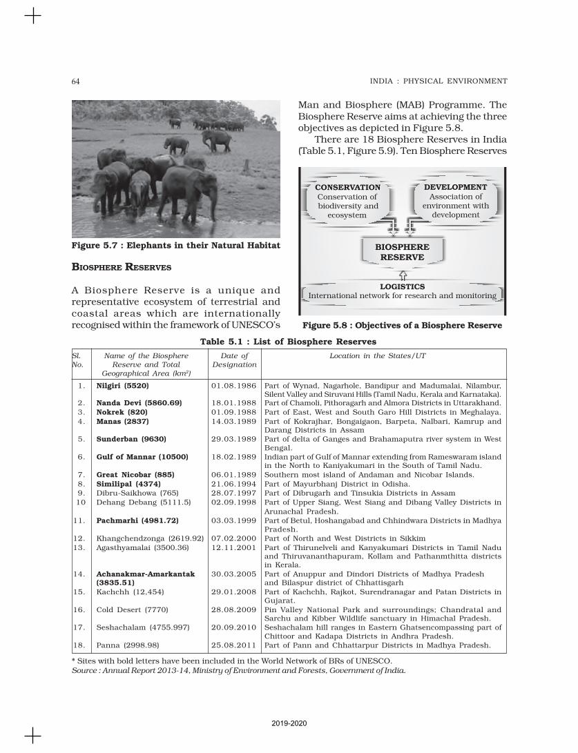
64 INDIA : PHYSICAL ENVIRONMENT
Figure 5.8 : Objectives of a Biosphere Reserve
BIOSPHERE RESERVES
A Biosphere Reserve is a unique andrepresentative ecosystem of terrestrial andcoastal areas which are internationallyrecognised within the framework of UNESCO’s
Man and Biosphere (MAB) Programme. TheBiosphere Reserve aims at achieving the threeobjectives as depicted in Figure 5.8.
There are 18 Biosphere Reserves in India(Table 5.1, Figure 5.9). Ten Biosphere Reserves
Figure 5.7 : Elephants in their Natural Habitat
Table 5.1 : List of Biosphere Reserves
* Sites with bold letters have been included in the World Network of BRs of UNESCO.Source : Annual Report 2013-14, Ministry of Environment and Forests, Government of India.
Sl. Name of the Biosphere Date of Location in the States/UT
No. Reserve and Total Designation
Geographical Area (km2)
1. Nilgiri (5520) 01.08.1986 Part of Wynad, Nagarhole, Bandipur and Madumalai, Nilambur,Silent Valley and Siruvani Hills (Tamil Nadu, Kerala and Karnataka).
2. Nanda Devi (5860.69) 18.01.1988 Part of Chamoli, Pithoragarh and Almora Districts in Uttarakhand.
3. Nokrek (820) 01.09.1988 Part of East, West and South Garo Hill Districts in Meghalaya.
4. Manas (2837) 14.03.1989 Part of Kokrajhar, Bongaigaon, Barpeta, Nalbari, Kamrup andDarang Districts in Assam
5. Sunderban (9630) 29.03.1989 Part of delta of Ganges and Brahamaputra river system in WestBengal.
6. Gulf of Mannar (10500) 18.02.1989 Indian part of Gulf of Mannar extending from Rameswaram islandin the North to Kaniyakumari in the South of Tamil Nadu.
7. Great Nicobar (885) 06.01.1989 Southern most island of Andaman and Nicobar Islands.
8. Similipal (4374) 21.06.1994 Part of Mayurbhanj District in Odisha.
9. Dibru-Saikhowa (765) 28.07.1997 Part of Dibrugarh and Tinsukia Districts in Assam
10 Dehang Debang (5111.5) 02.09.1998 Part of Upper Siang, West Siang and Dibang Valley Districts in
Arunachal Pradesh.
11. Pachmarhi (4981.72) 03.03.1999 Part of Betul, Hoshangabad and Chhindwara Districts in MadhyaPradesh.
12. Khangchendzonga (2619.92) 07.02.2000 Part of North and West Districts in Sikkim
13. Agasthyamalai (3500.36) 12.11.2001 Part of Thirunelveli and Kanyakumari Districts in Tamil Naduand Thiruvananthapuram, Kollam and Pathanmthitta districtsin Kerala.
14. Achanakmar-Amarkantak 30.03.2005 Part of Anuppur and Dindori Districts of Madhya Pradesh(3835.51) and Bilaspur district of Chhattisgarh
15. Kachchh (12,454) 29.01.2008 Part of Kachchh, Rajkot, Surendranagar and Patan Districts inGujarat.
16. Cold Desert (7770) 28.08.2009 Pin Valley National Park and surroundings; Chandratal andSarchu and Kibber Wildlife sanctuary in Himachal Pradesh.
17. Seshachalam (4755.997) 20.09.2010 Seshachalam hill ranges in Eastern Ghatsencompassing part ofChittoor and Kadapa Districts in Andhra Pradesh.
18. Panna (2998.98) 25.08.2011 Part of Pann and Chhattarpur Districts in Madhya Pradesh.
2019-2020

65NATURAL VEGETATION
Figure 5.9 : India : Biosphere Reserves
2019-2020
66 INDIA : PHYSICAL ENVIRONMENT
EXERCISES
have been recognised by the UNESCO on WorldNetwork of Biosphere Reserves.
Nilgiri Biosphere Reserve
The Nilgiri Biosphere Reserve (NBR), the firstof the fourteen biosphere reserves of India, wasestablished in September 1986. It embracesthe sanctuary complex of Wyanad, Nagarhole,Bandipur and Mudumalai, the entire forestedhill slopes of Nilambur, the Upper Nilgiriplateau, Silent Valley and the Siruvani hills.The total area of the biosphere reserve isaround 5,520 sq. km.
The Nilgiri Biosphere Reserve possessesdifferent habitat types, unspoilt areas ofnatural vegetation types with several dryscrubs, dry and moist deciduous, semi-evergreen and wet evergreen forests, evergreensholas, grasslands and swamps. It includesthe largest known population of twoendangered animal species, namely the NilgiriTahr and the Lion-tailed macaque. The largestsouth Indian population of elephant, tiger,gaur, sambar and chital as well as a goodnumber of endemic and endangered plants arealso found in this reserve. The habitat of anumber of tribal groups remarkable for theirtraditional modes of harmonious use of theenvironment are also found here.
The topography of the NBR is extremelyvaried, ranging from an altitude of 250 m to2,650 m. About 80 per cent of the floweringplants reported from the Western Ghats occurin the Nilgiri Biosphere Reserve.
Nanda Devi Biosphere Reserve
The Nanda Devi Biosphere Reserve situatedin Uttarakhand includes parts of Chamoli,Almora, Pithoragarh and Bageshwar districts.
The major forest types of the reserve aretemperate. A few important species are silverweed and orchids like latifolie and
rhododendron. The biosphere reserve has a
rich fauna, for example the snow leopard,black bear, brown bear, musk deer, snow-
cock, golden eagle and black eagle.
Major threats to the ecosystem are the
collection of endangered plants for medicinaluse, forest fires and poaching.
Sunderbans Biosphere Reserve
It is located in the swampy delta of the riverGanga in West Bengal. It extends over a vast
area of 9,630 sq. km and consists of mangrove
forests, swamps and forested islands.
Sunderbans is the home of nearly 200 RoyalBengal tigers.
The tangled mass of roots of mangrove
trees provide safe homes for a large number
of species, from fish to shrimp. More than 170birds species are known to inhabit these
mangrove forests.
Adapting itself to the saline and fresh water
environment, the tigers at the park are goodswimmers, and they hunt scarce preys such
as chital deer, barking deer, wild pig and even
macaques. In the Sunderbans, the mangrove
forests are characterised by Heritiera fomes,a species valued for its timber.
Gulf of Mannar Biosphere Reserve
The Gulf of Mannar Biosphere Reserve coversan area of 105,000 hectares on the southeast
coast of India. It is one of the world’s richest
regions from a marine biodiversity perspective.
The biosphere reserve comprises 21 islandswith estuaries, beaches, forests of the
nearshore environment, sea grasses, coral
reefs, salt marshes and mangroves. Among the
Gulf’’s 3,600 plant and animal species are theglobally endangered e.g. sea cow (Dugong
dugon). Besides six mangrove species, endemic
to Peninsular India are also endangered.
1. Choose the right answer from the four alternatives given below.
(i) Sandalwood is an example of:(a) Evergreen forest (c) Deltaic forest
(b) Deciduous forest (d) Thorny forest
2019-2020

67NATURAL VEGETATION
(ii) Which one of the following was the purpose of Project Tiger?
(a) to kill tigers (c) to protect tigers from illegal hunting
(b) to put tigers in the Zoo (d) to make films on tigers
(iii) In which one of the following states is the Nandadevi Biosphere reservesituated?
(a) Bihar (c) Uttarakhand
(b) Uttar Pradesh (d) Odisha
(iv) How many of the Biosphere reserves from India are recognised by theUNESCO?
(a) One (c) Ten
(b) Two (d) Four
(v) Which one of the following proportion of area of the country was targetedto be under forest in Forest Policy of India?
(a) 33 (c) 55
(b) 44 (d) 22
2. Answer the following questions in about 30 words.
(i) What is natural vegetation? Under what climatic conditions are tropicalevergreen forests develop?
(ii) What do you understand by social forestry?
(iii) Define Biosphere reserves?
(iv) What is the difference between forest area and forest cover?
3. Answer the following questions in not more than 150 words.
(i) What steps have been taken up to conserve forests?
(ii) How can people’s participation be effective in conserving forests and wildlife?
Project/Activity
1. On the outline map of India, mark and label the following.
(i) Areas having Mangrove forests.
(ii) Biosphere reserves of Nanda Devi, Sunderbans, Gulf of Mannar and Nilgiri.
(iii) Mark the location of Forest Survey of India Head Quarter.2. List the trees, bush and shrub species found around your school. Write
their local names and their uses.
2019-2020
Have you ever thought about the mostimportant factor which supports trees,grasses, crops and numerous life-
forms over the earth’s surface? Can one growa blade of grass without soil? While someplants and organisms which are aquatic innature can sustain in water, do they not derivenutrients from soil through water? You willrealise that soil is the most important layer ofthe earth’s crust. It is a valuable resource. Thebulk of our food and much of our clothing isderived from land-based crops that grow in thesoil. The soil on which we depend so much forour day-to-day needs has evolved overthousands of years. The various agents ofweathering and gradation have acted upon theparent rock material to produce a thin layer ofsoil.
Soil is the mixture of rock debris andorganic materials which develop on the earth’ssurface. The major factors affecting theformation of soil are relief, parent material,climate, vegetation and other life-forms andtime. Besides these, human activities alsoinfluence it to a large extent. Components ofthe soil are mineral particles, humus, water andair. The actual amount of each of these dependupon the type of soil. Some soils are deficientin one or more of these, while there are someothers that have varied combinations.
Have you ever dug a pit in the field of yourschool to plant a tree while celebrating Van-Mahotsava? Was the pit of uniform layer of soilor did you notice different colours from the topto the bottom of the pit?
If we dig a pit on land and look at the soil,we find that it consists of three layers which
are called horizons. ‘Horizon A’ is the topmostzone, where organic materials have got
incorporated with the mineral matter,nutrients and water, which are necessary forthe growth of plants. ‘Horizon B’ is a transition
zone between the ‘horizon A’ and ‘horizon C’,and contains matter derived from below as wellas from above. It has some organic matter in
it, although the mineral matter is noticeablyweathered. ‘Horizon C’ is composed of the looseparent material. This layer is the first stage in
the soil formation process and eventually formsthe above two layers. This arrangement of layersis known as the soil profile. Underneath these
three horizons is the rock which is also knownas the parent rock or the bedrock. Soil, whichis a complex and varied entity has always
drawn the attention of the scientists. In orderto understand its importance, it is essential toattempt a scientific study of the soil.
Classification of the soil is an effort to achievethis objective.
CLASSIFICATION OF SOILS
India has varied relief features, landforms,climatic realms and vegetation types. Thesehave contributed in the development of varioustypes of soils in India.
In ancient times, soils used to be classifiedinto two main groups – Urvara and Usara,
which were fertile and sterile, respectively. Inthe 16th centrury A.D., soils were classified onthe basis of their inherent characteristics andexternal features such as texture, colour, slopeof land and moisture content in the soil. Basedon texture, main soil types were identified as
SOILS
C H A P T E R
2019-2020
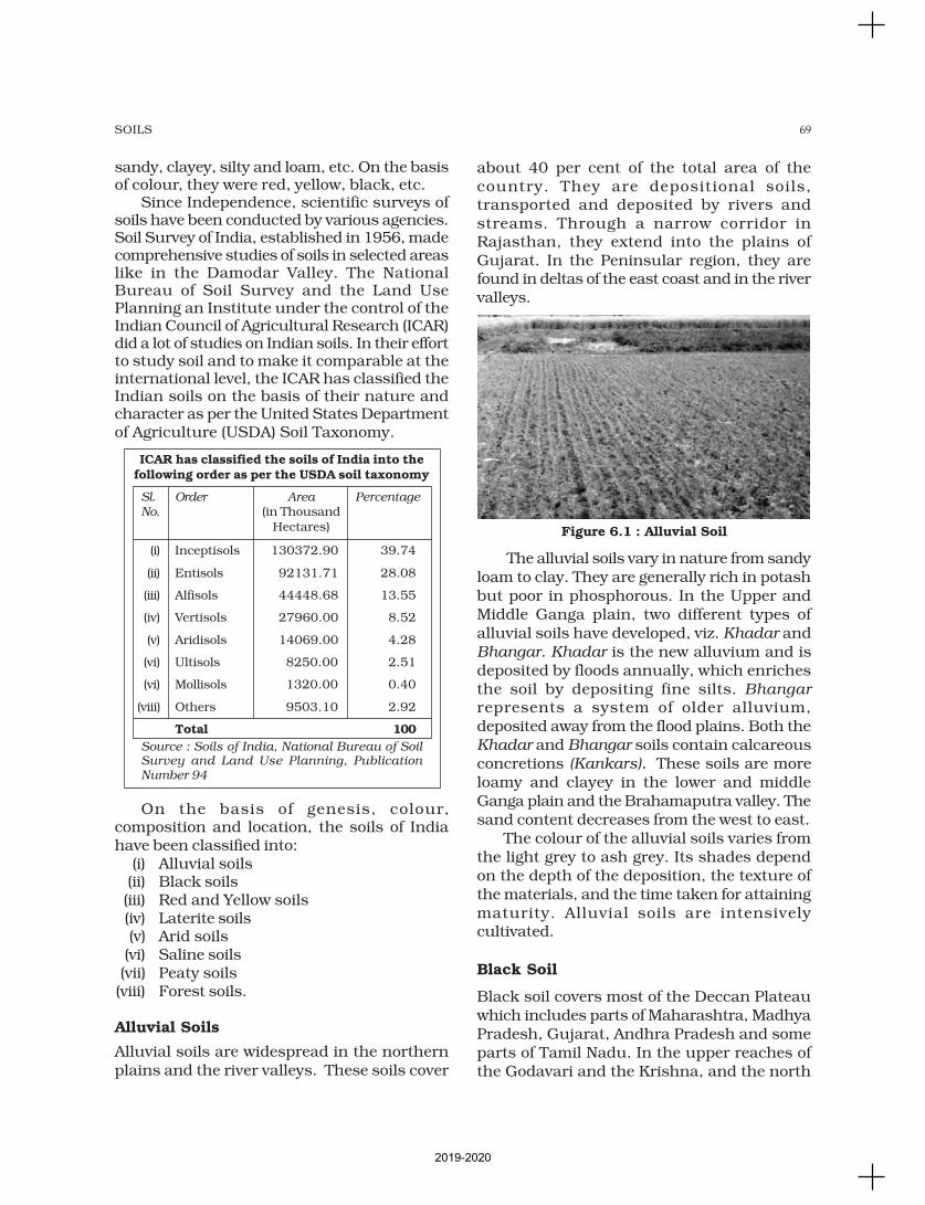
69SOILS
sandy, clayey, silty and loam, etc. On the basisof colour, they were red, yellow, black, etc.
Since Independence, scientific surveys ofsoils have been conducted by various agencies.Soil Survey of India, established in 1956, madecomprehensive studies of soils in selected areaslike in the Damodar Valley. The NationalBureau of Soil Survey and the Land UsePlanning an Institute under the control of theIndian Council of Agricultural Research (ICAR)did a lot of studies on Indian soils. In their effortto study soil and to make it comparable at theinternational level, the ICAR has classified theIndian soils on the basis of their nature andcharacter as per the United States Departmentof Agriculture (USDA) Soil Taxonomy.
ICAR has classified the soils of India into thefollowing order as per the USDA soil taxonomy
Sl. Order Area Percentage
No. (in ThousandHectares)
(i) Inceptisols 130372.90 39.74
(ii) Entisols 92131.71 28.08
(iii) Alfisols 44448.68 13.55
(iv) Vertisols 27960.00 8.52
(v) Aridisols 14069.00 4.28
(vi) Ultisols 8250.00 2.51
(vi) Mollisols 1320.00 0.40
(viii) Others 9503.10 2.92
Total 100
Source : Soils of India, National Bureau of SoilSurvey and Land Use Planning, PublicationNumber 94
On the basis of genesis, colour,composition and location, the soils of Indiahave been classified into:
(i) Alluvial soils(ii) Black soils(iii) Red and Yellow soils(iv) Laterite soils(v) Arid soils(vi) Saline soils(vii) Peaty soils(viii) Forest soils.
Alluvial Soils
Alluvial soils are widespread in the northernplains and the river valleys. These soils cover
about 40 per cent of the total area of thecountry. They are depositional soils,transported and deposited by rivers andstreams. Through a narrow corridor inRajasthan, they extend into the plains ofGujarat. In the Peninsular region, they arefound in deltas of the east coast and in the rivervalleys.
The alluvial soils vary in nature from sandyloam to clay. They are generally rich in potashbut poor in phosphorous. In the Upper andMiddle Ganga plain, two different types ofalluvial soils have developed, viz. Khadar andBhangar. Khadar is the new alluvium and isdeposited by floods annually, which enrichesthe soil by depositing fine silts. Bhangar
represents a system of older alluvium,deposited away from the flood plains. Both theKhadar and Bhangar soils contain calcareousconcretions (Kankars). These soils are moreloamy and clayey in the lower and middleGanga plain and the Brahamaputra valley. Thesand content decreases from the west to east.
The colour of the alluvial soils varies fromthe light grey to ash grey. Its shades dependon the depth of the deposition, the texture ofthe materials, and the time taken for attainingmaturity. Alluvial soils are intensivelycultivated.
Black Soil
Black soil covers most of the Deccan Plateauwhich includes parts of Maharashtra, MadhyaPradesh, Gujarat, Andhra Pradesh and someparts of Tamil Nadu. In the upper reaches ofthe Godavari and the Krishna, and the north
Figure 6.1 : Alluvial Soil
2019-2020
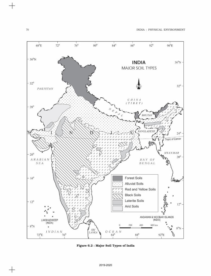
70 INDIA : PHYSICAL ENVIRONMENT
Figure 6.2 : Major Soil Types of India
2019-2020
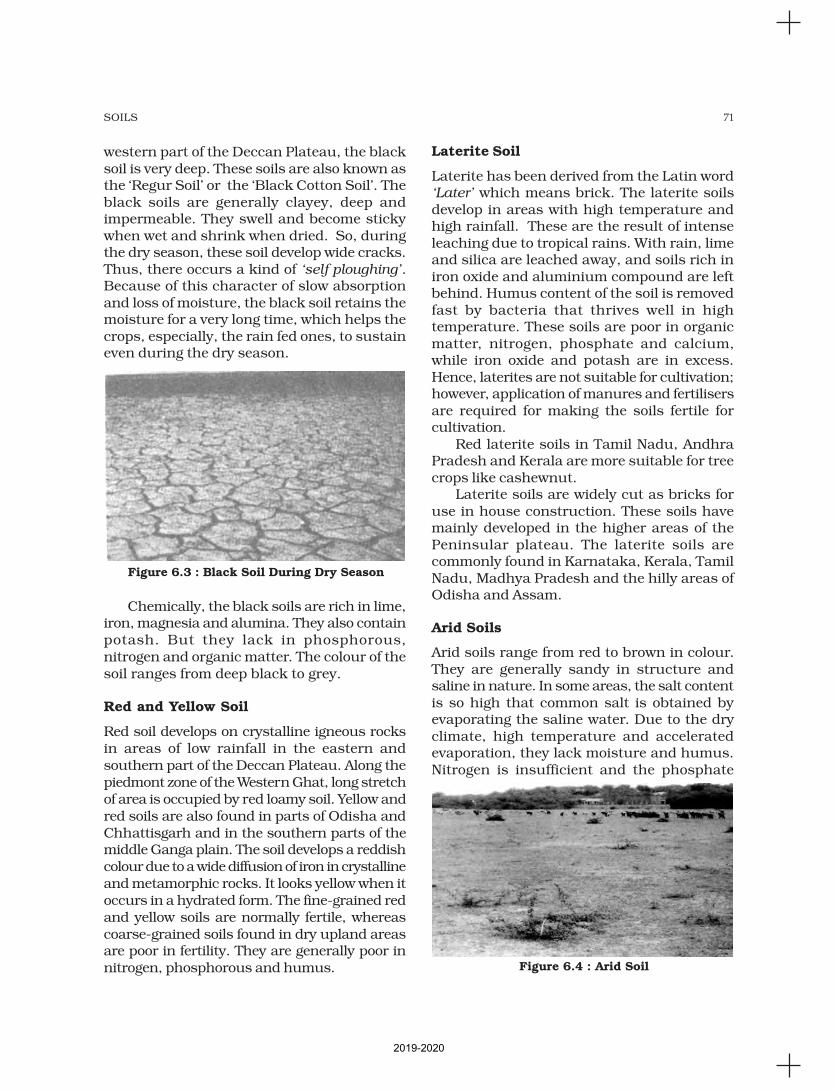
71SOILS
western part of the Deccan Plateau, the blacksoil is very deep. These soils are also known asthe ‘Regur Soil’ or the ‘Black Cotton Soil’. Theblack soils are generally clayey, deep andimpermeable. They swell and become stickywhen wet and shrink when dried. So, duringthe dry season, these soil develop wide cracks.Thus, there occurs a kind of ‘self ploughing’.Because of this character of slow absorptionand loss of moisture, the black soil retains themoisture for a very long time, which helps thecrops, especially, the rain fed ones, to sustaineven during the dry season.
Chemically, the black soils are rich in lime,iron, magnesia and alumina. They also containpotash. But they lack in phosphorous,nitrogen and organic matter. The colour of thesoil ranges from deep black to grey.
Red and Yellow Soil
Red soil develops on crystalline igneous rocksin areas of low rainfall in the eastern andsouthern part of the Deccan Plateau. Along thepiedmont zone of the Western Ghat, long stretchof area is occupied by red loamy soil. Yellow andred soils are also found in parts of Odisha andChhattisgarh and in the southern parts of themiddle Ganga plain. The soil develops a reddishcolour due to a wide diffusion of iron in crystallineand metamorphic rocks. It looks yellow when itoccurs in a hydrated form. The fine-grained redand yellow soils are normally fertile, whereascoarse-grained soils found in dry upland areasare poor in fertility. They are generally poor innitrogen, phosphorous and humus.
Laterite Soil
Laterite has been derived from the Latin word‘Later’ which means brick. The laterite soilsdevelop in areas with high temperature andhigh rainfall. These are the result of intenseleaching due to tropical rains. With rain, limeand silica are leached away, and soils rich iniron oxide and aluminium compound are leftbehind. Humus content of the soil is removedfast by bacteria that thrives well in hightemperature. These soils are poor in organicmatter, nitrogen, phosphate and calcium,while iron oxide and potash are in excess.Hence, laterites are not suitable for cultivation;however, application of manures and fertilisersare required for making the soils fertile forcultivation.
Red laterite soils in Tamil Nadu, AndhraPradesh and Kerala are more suitable for treecrops like cashewnut.
Laterite soils are widely cut as bricks foruse in house construction. These soils havemainly developed in the higher areas of thePeninsular plateau. The laterite soils arecommonly found in Karnataka, Kerala, TamilNadu, Madhya Pradesh and the hilly areas ofOdisha and Assam.
Arid Soils
Arid soils range from red to brown in colour.They are generally sandy in structure andsaline in nature. In some areas, the salt contentis so high that common salt is obtained byevaporating the saline water. Due to the dryclimate, high temperature and acceleratedevaporation, they lack moisture and humus.Nitrogen is insufficient and the phosphate
Figure 6.3 : Black Soil During Dry Season
Figure 6.4 : Arid Soil
2019-2020
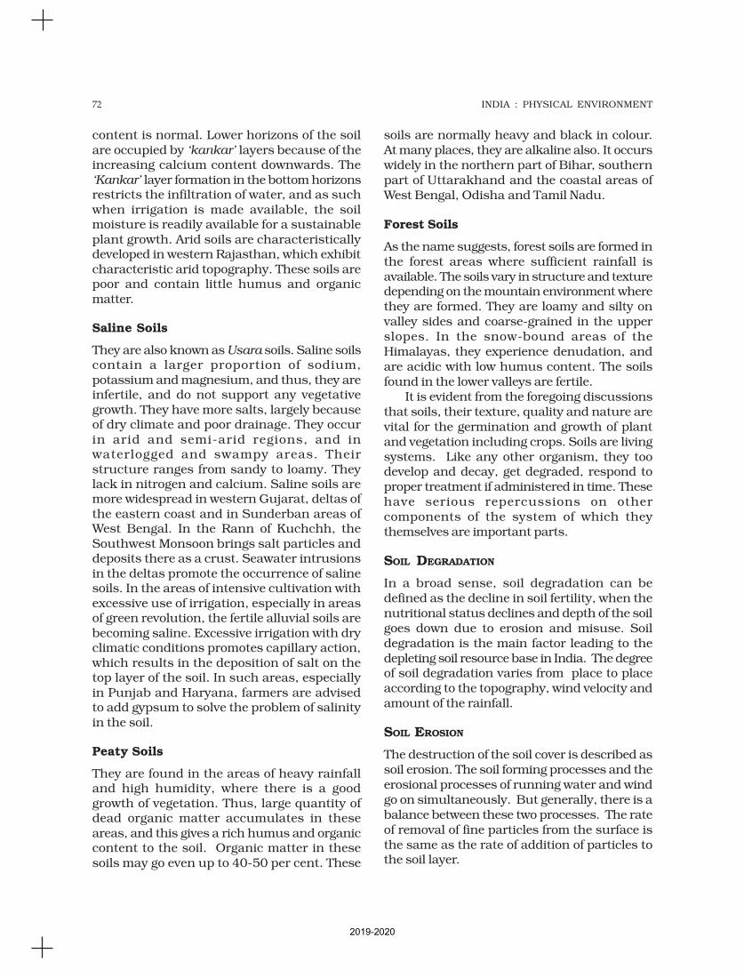
72 INDIA : PHYSICAL ENVIRONMENT
content is normal. Lower horizons of the soilare occupied by ‘kankar’ layers because of theincreasing calcium content downwards. The‘Kankar’ layer formation in the bottom horizonsrestricts the infiltration of water, and as suchwhen irrigation is made available, the soilmoisture is readily available for a sustainableplant growth. Arid soils are characteristicallydeveloped in western Rajasthan, which exhibitcharacteristic arid topography. These soils arepoor and contain little humus and organicmatter.
Saline Soils
They are also known as Usara soils. Saline soilscontain a larger proportion of sodium,potassium and magnesium, and thus, they areinfertile, and do not support any vegetativegrowth. They have more salts, largely becauseof dry climate and poor drainage. They occurin arid and semi-arid regions, and inwaterlogged and swampy areas. Theirstructure ranges from sandy to loamy. Theylack in nitrogen and calcium. Saline soils aremore widespread in western Gujarat, deltas ofthe eastern coast and in Sunderban areas ofWest Bengal. In the Rann of Kuchchh, theSouthwest Monsoon brings salt particles anddeposits there as a crust. Seawater intrusionsin the deltas promote the occurrence of salinesoils. In the areas of intensive cultivation withexcessive use of irrigation, especially in areasof green revolution, the fertile alluvial soils arebecoming saline. Excessive irrigation with dryclimatic conditions promotes capillary action,which results in the deposition of salt on thetop layer of the soil. In such areas, especiallyin Punjab and Haryana, farmers are advisedto add gypsum to solve the problem of salinityin the soil.
Peaty Soils
They are found in the areas of heavy rainfalland high humidity, where there is a goodgrowth of vegetation. Thus, large quantity ofdead organic matter accumulates in theseareas, and this gives a rich humus and organiccontent to the soil. Organic matter in thesesoils may go even up to 40-50 per cent. These
soils are normally heavy and black in colour.At many places, they are alkaline also. It occurswidely in the northern part of Bihar, southernpart of Uttarakhand and the coastal areas ofWest Bengal, Odisha and Tamil Nadu.
Forest Soils
As the name suggests, forest soils are formed inthe forest areas where sufficient rainfall isavailable. The soils vary in structure and texturedepending on the mountain environment wherethey are formed. They are loamy and silty onvalley sides and coarse-grained in the upperslopes. In the snow-bound areas of theHimalayas, they experience denudation, andare acidic with low humus content. The soilsfound in the lower valleys are fertile.
It is evident from the foregoing discussionsthat soils, their texture, quality and nature arevital for the germination and growth of plantand vegetation including crops. Soils are livingsystems. Like any other organism, they toodevelop and decay, get degraded, respond toproper treatment if administered in time. Thesehave serious repercussions on othercomponents of the system of which theythemselves are important parts.
SOIL DEGRADATION
In a broad sense, soil degradation can bedefined as the decline in soil fertility, when thenutritional status declines and depth of the soilgoes down due to erosion and misuse. Soildegradation is the main factor leading to thedepleting soil resource base in India. The degreeof soil degradation varies from place to placeaccording to the topography, wind velocity andamount of the rainfall.
SOIL EROSION
The destruction of the soil cover is described assoil erosion. The soil forming processes and theerosional processes of running water and windgo on simultaneously. But generally, there is abalance between these two processes. The rateof removal of fine particles from the surface isthe same as the rate of addition of particles tothe soil layer.
2019-2020
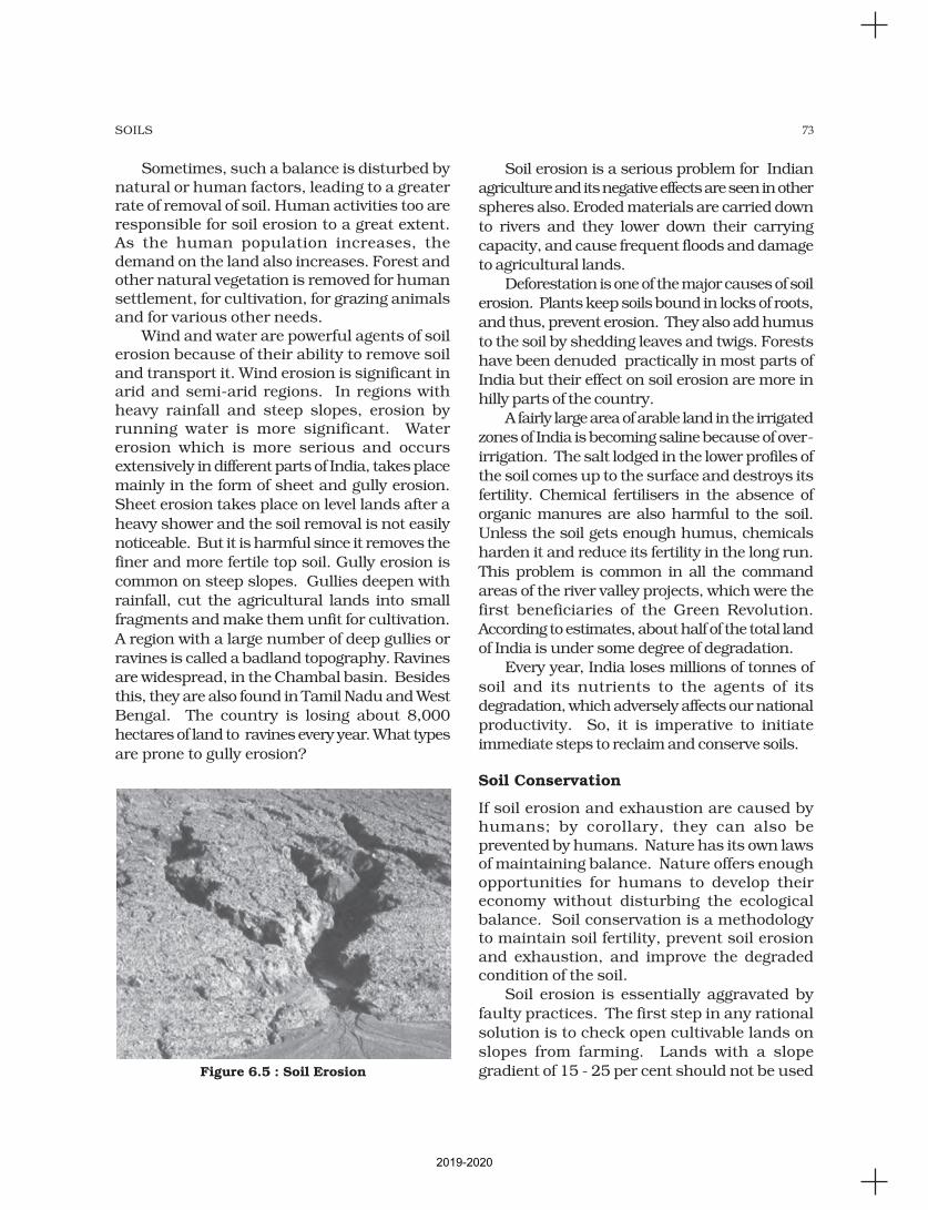
73SOILS
Sometimes, such a balance is disturbed bynatural or human factors, leading to a greaterrate of removal of soil. Human activities too areresponsible for soil erosion to a great extent.As the human population increases, thedemand on the land also increases. Forest andother natural vegetation is removed for humansettlement, for cultivation, for grazing animalsand for various other needs.
Wind and water are powerful agents of soilerosion because of their ability to remove soiland transport it. Wind erosion is significant inarid and semi-arid regions. In regions withheavy rainfall and steep slopes, erosion byrunning water is more significant. Watererosion which is more serious and occursextensively in different parts of India, takes place
mainly in the form of sheet and gully erosion.
Sheet erosion takes place on level lands after a
heavy shower and the soil removal is not easily
noticeable. But it is harmful since it removes the
finer and more fertile top soil. Gully erosion is
common on steep slopes. Gullies deepen with
rainfall, cut the agricultural lands into small
fragments and make them unfit for cultivation.
A region with a large number of deep gullies or
ravines is called a badland topography. Ravines
are widespread, in the Chambal basin. Besides
this, they are also found in Tamil Nadu and West
Bengal. The country is losing about 8,000
hectares of land to ravines every year. What types
are prone to gully erosion?
Soil erosion is a serious problem for Indian
agriculture and its negative effects are seen in other
spheres also. Eroded materials are carried down
to rivers and they lower down their carrying
capacity, and cause frequent floods and damage
to agricultural lands.
Deforestation is one of the major causes of soil
erosion. Plants keep soils bound in locks of roots,
and thus, prevent erosion. They also add humus
to the soil by shedding leaves and twigs. Forests
have been denuded practically in most parts of
India but their effect on soil erosion are more in
hilly parts of the country.
A fairly large area of arable land in the irrigated
zones of India is becoming saline because of over-
irrigation. The salt lodged in the lower profiles of
the soil comes up to the surface and destroys its
fertility. Chemical fertilisers in the absence of
organic manures are also harmful to the soil.
Unless the soil gets enough humus, chemicals
harden it and reduce its fertility in the long run.
This problem is common in all the command
areas of the river valley projects, which were the
first beneficiaries of the Green Revolution.
According to estimates, about half of the total land
of India is under some degree of degradation.
Every year, India loses millions of tonnes of
soil and its nutrients to the agents of its
degradation, which adversely affects our national
productivity. So, it is imperative to initiate
immediate steps to reclaim and conserve soils.
Soil Conservation
If soil erosion and exhaustion are caused byhumans; by corollary, they can also beprevented by humans. Nature has its own lawsof maintaining balance. Nature offers enoughopportunities for humans to develop theireconomy without disturbing the ecologicalbalance. Soil conservation is a methodologyto maintain soil fertility, prevent soil erosionand exhaustion, and improve the degradedcondition of the soil.
Soil erosion is essentially aggravated by
faulty practices. The first step in any rational
solution is to check open cultivable lands on
slopes from farming. Lands with a slope
gradient of 15 - 25 per cent should not be usedFigure 6.5 : Soil Erosion
2019-2020

74 INDIA : PHYSICAL ENVIRONMENT
for cultivation. If at all the land is to be used
for agriculture, terraces should carefully be
made. Over-grazing and shifting cultivation in
many parts of India have affected the natural
cover of land and given rise to extensive erosion.
It should be regulated and controlled by
educating villagers about the consequences.
Contour bunding, Contour terracing,
regulated forestry, controlled grazing, cover
cropping, mixed farming and crop rotation are
some of the remedial measures which are often
adopted to reduce soil erosion.
Efforts should be made to prevent gully
erosion and control their formation. Finger
gullies can be eliminated by terracing. In
bigger gullies, the erosive velocity of water may
be reduced by constructing a series of check
dams. Special attention should be made to
control headward extension of gullies. This can
be done by gully plugging, terracing or by
planting cover vegetation.
In arid and semi-arid areas, efforts should
be made to protect cultivable lands from
encroachment by sand dunes through
developing shelter belts of trees and
agro-forestry. Lands not suitable for
cultivation should be converted into pastures
for grazing. Experiments have been made to
stabilise sand dunes in western Rajasthan by
the Central Arid Zone Research Institute
(CAZRI).
The Central Soil Conservation Board, set up
by the Government of India, has prepared a
number of plans for soil conservation in different
parts of the country. These plans are based on
the climatic conditions, configuration of land
and the social behaviour of people. Even these
plans are fragmental in nature. Integrated land
use planning, therefore, seems to be the best
technique for proper soil conservation. Lands
should be classified according to their
capability; land use maps should be prepared
and lands should be put to right uses. The final
responsibility for achieving the conservation of
land will rest on the people who operate on it
and receive the benefits.
Figure 6.6 : Terrace Farming
1. Choose the right answer from the four alternatives given below.
(i) Which one of the following is the most widespread and most productivecategory of soil?
(a) Alluvial Soil (c) Black Soil
(b) Laterite Soil (d) Forest Soil
(ii) ‘Regur Soil’ is another name for the.
(a) Saline Soil (c) Black Soil
(b) Arid Soil (d) Laterite Soil
(iii) Which one of the following is the main reason for the loss of the top soilin India?
(a) Wind erosion (c) Excessive leaching
(b) Water erosion (d) None of these
EXERCISES
2019-2020
75SOILS
(iv) Arable land in the irrigated zones of India is turning saline due to whichof the following reasons?
(a) Addition of gypsum (c) Over irrigation
(b) Over grazing (d) Use of fertilisers
2. Answer the following questions in about 30 words.
(i) What is soil?
(ii) What are the main factors responsible for the formation of soil?
(iii) Mention the three horizons of a soil profile.
(iv) What is soil degradation?
(v) What is the difference between Khadar and Bhangar?
3. Answer the following questions in not more than 125 words.
(i) What are black soils? Describe their formation and characteristics.
(ii) What is soil conservation? Suggest some measures to conserve soil.
(iii) How do you know that a particular type of soil is fertile or not? Differentiatebetween naturally determined fertility and culturally induced fertility.
Project/Activity
1. Collect various samples of soil and prepare a report on the type(s) of soilsfound in your region.
2. On an outline map of India, mark the areas coverd by the following soilcategories.
(i) Red soil
(ii) Laterite soil
(iii) Alluvial soil.
2019-2020