Introduction - City of Sydney
13
\\GLOBAL.ARUP.COM\AUSTRALASIA\SYD\PROJECTS\270000\270416-00 187 THOMAS STREET\WORK\INTERNAL\REPORTS\05 GEO & CIVIL\GEO\03REPORT\2020 03 06 ISSUE 2\270416-RPT-001_ISSUE2.DOCX Arup Pty Ltd ABN 18 000 966 165 Your ref 187 Thomas St Our ref 270416-02 File ref 270416-RPT-001 Level 5 151 Clarence Street Sydney NSW 2000 Australia t +61 2 9320 9320 d +61 2 9320 9320 f +61 2 9320 9321 [email protected] www.arup.com Peter Jones Development Manager Level 20, 20 Bond Street Sydney NSW 2000, Australia 13 March 2020 Dear Peter 187 Thomas Street Planning Proposal - Reference Scheme Option 5E - Geotechnical Desktop Assessment 1 Introduction Arup have been engaged by Greaton Development to undertake a geotechnical desktop study assessment, to inform Planning Proposal of the redevelopment at 187 Thomas Street, Sydney New South Wales. This assessment is only to inform the current Reference Scheme. The current building comprises a 15-storey office building, inclusive of two basement levels. A detailed project description for the proposed structure is in Section 2. This technical note summarises the findings of the desk top study, which included a review of published geological information and previous ground investigation. Based on the information obtained during the study, gaps in available/reviewed data have been identified and high-level recommendations for any additional geotechnical investigation are also provided. 2 Reference Scheme Project Description The proposal seeks to amend planning controls applying to the Site to allow a future development that will comprise an integrated community and destination for the innovation and technology sectors in the form of a vertical innovation village with an overall maximum height of 49 storeys (RL 209.80) and approximate commercial GFA of 51,700m 2 . Within a hybrid tower the concept will deliver approximately 51,700m 2 of GFA to a maximum height of RL 207. As illustrated in the reference scheme the hybrid tower will comprise flexible interconnected floorplates of approximately: 1000m 2 on the ground level; 1,700m 2 within the podium; 610 - 760m 2 within the void tower; 1,200m 2 within the low and high rise tower; and 900m 2 GFA within the sky rise tower thereby catering to the full range of enterprises within the sector.
Transcript of Introduction - City of Sydney

\\GLOBAL.ARUP.COM\AUSTRALASIA\SYD\PROJECTS\270000\270416-00 187 THOMAS
STREET\WORK\INTERNAL\REPORTS\05 GEO & CIVIL\GEO\03REPORT\2020 03 06 ISSUE
2\270416-RPT-001_ISSUE2.DOCX Arup Pty Ltd ABN 18 000 966 165
Your ref 187 Thomas St
Our ref 270416-02
File ref 270416-RPT-001
Level 5 151 Clarence Street Sydney NSW 2000
Australia
t +61 2 9320 9320 d +61 2 9320 9320 f +61 2 9320 9321
[email protected] www.arup.com
Peter Jones
Development Manager
Level 20, 20 Bond Street
Sydney NSW 2000, Australia
13 March 2020
Dear Peter
187 Thomas Street Planning Proposal - Reference Scheme Option 5E - Geotechnical Desktop Assessment
1 Introduction
Arup have been engaged by Greaton Development to undertake a geotechnical desktop
study assessment, to inform Planning Proposal of the redevelopment at 187 Thomas Street,
Sydney New South Wales. This assessment is only to inform the current Reference
Scheme. The current building comprises a 15-storey office building, inclusive of two
basement levels. A detailed project description for the proposed structure is in Section 2.
This technical note summarises the findings of the desk top study, which included a review
of published geological information and previous ground investigation. Based on the
information obtained during the study, gaps in available/reviewed data have been identified
and high-level recommendations for any additional geotechnical investigation are also
provided.
2 Reference Scheme Project Description
The proposal seeks to amend planning controls applying to the Site to allow a future
development that will comprise an integrated community and destination for the
innovation and technology sectors in the form of a vertical innovation village with an
overall maximum height of 49 storeys (RL 209.80) and approximate commercial GFA of
51,700m2.
Within a hybrid tower the concept will deliver approximately 51,700m2 of GFA to a
maximum height of RL 207. As illustrated in the reference scheme the hybrid tower will
comprise flexible interconnected floorplates of approximately: 1000m2 on the ground level;
1,700m2 within the podium; 610 - 760m2 within the void tower; 1,200m2 within the low
and high rise tower; and 900m2 GFA within the sky rise tower thereby catering to the full
range of enterprises within the sector.
270416-02
13 March 2020 Page 2 of 13
\\GLOBAL.ARUP.COM\AUSTRALASIA\SYD\PROJECTS\270000\270416-00 187 THOMAS
STREET\WORK\INTERNAL\REPORTS\05 GEO & CIVIL\GEO\03REPORT\2020 03 06 ISSUE
2\270416-RPT-001_ISSUE2.DOCX
Key components of the reference scheme for the hybrid tower include:
• Innovation tech hub (approximately 8,600m2 GFA) within the basement, podium and
void tower with lobby off Valentine Street including:
• tech workshop with shared equipment, facilities and services (including education,
business support, programming, safety management and training)
• co-working space for the innovation industries that utilise provided technology and
equipment, that changes in space and floor plate design to accommodate growing
businesses, and
• terrace on Level 4 of the Void Tower providing an indoor / outdoor workspace
• facilities and services shared with the tech hotel.
• Commercial office space (approximately 33,100m2 GFA) for the corporate tech sector
within the low and high rise tower with lobby off Quay Street
• 4 star Tech Hotel (approximately 9,800m2 GFA / 234 keys with 26 rooms per floor)
within the sky rise tower with sky lobby, pool and bar with drop off and lobby off
Thomas Street
• Meeting, forum, gym, pool, hospitality and other spaces integrated throughout the
building and shared (and co-managed) between the innovation hub, commercial
tenancies and tech hotel
• A retail offering of approximately 220m2 GFA, including food and beverage which
will be located on the ground level
• Upgraded (and widened) through site connection connecting Thomas Street to the west
with George Street to the east via an activated retail arcade connection
• Redeveloped public space on Thomas, Quay and Valentine Street including an
expanded pedestrian plaza at the corner of Thomas and Quay Streets and widening of
the Valentine Street footpath
• Integration with the proposed Quay Street public domain works to accommodate
increased pedestrian movement from existing and future pedestrian connections to
various modes of transport, and
• Five (5) basement levels beneath the building with access off Thomas Street in the
north west of the site.
The proposed basement levels will provide:
• Reduced car park provision totalling 79 car parking spaces (including 23 small car
spaces,2 car share spaces and 1 electric charging station) (Note: maximum parking
allowed 107 spaces however reduced provision proposed as transport demand
strategy. 86 spaces currently provided on site)
• 14 motorbike parking spaces
• 382 bicycle parking spaces for staff and visitors as well as end of trip (EoT) facilities
• Hotel back of house areas
• loading dock and waste storage room, and
• plant and equipment areas.
270416-02
13 March 2020 Page 3 of 13
\\GLOBAL.ARUP.COM\AUSTRALASIA\SYD\PROJECTS\270000\270416-00 187 THOMAS
STREET\WORK\INTERNAL\REPORTS\05 GEO & CIVIL\GEO\03REPORT\2020 03 06 ISSUE
2\270416-RPT-001_ISSUE2.DOCX
It should be noted that while the reference scheme represents one design for the proposed
hybrid tower, the project will be subject to a full competitive design process in accordance
with the requirements of Sydney LEP 2012.
3 Site Summary
3.1 Topography and Land Use
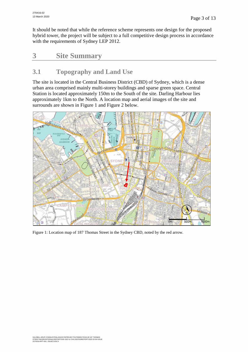
The site is located in the Central Business District (CBD) of Sydney, which is a dense
urban area comprised mainly multi-storey buildings and sparse green space. Central
Station is located approximately 150m to the South of the site. Darling Harbour lies
approximately 1km to the North. A location map and aerial images of the site and
surrounds are shown in Figure 1 and Figure 2 below.
Figure 1: Location map of 187 Thomas Street in the Sydney CBD, noted by the red arrow.
270416-02
13 March 2020 Page 4 of 13
\\GLOBAL.ARUP.COM\AUSTRALASIA\SYD\PROJECTS\270000\270416-00 187 THOMAS
STREET\WORK\INTERNAL\REPORTS\05 GEO & CIVIL\GEO\03REPORT\2020 03 06 ISSUE
2\270416-RPT-001_ISSUE2.DOCX
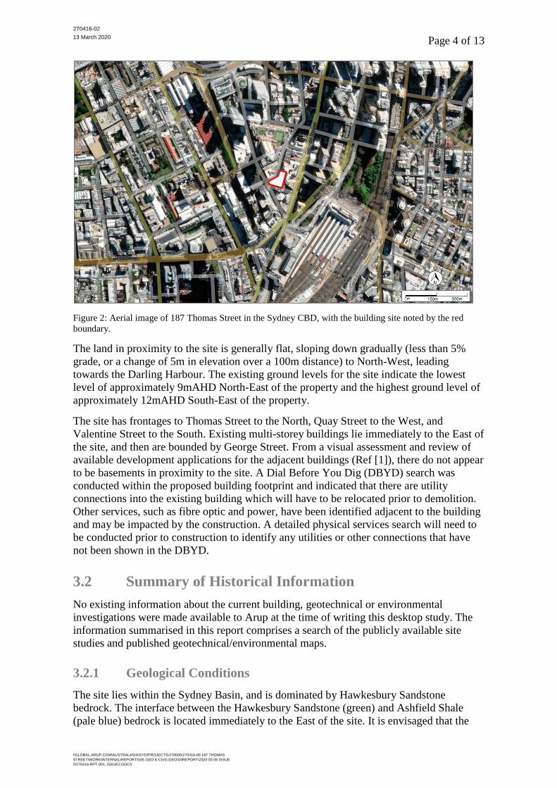
Figure 2: Aerial image of 187 Thomas Street in the Sydney CBD, with the building site noted by the red
boundary.
The land in proximity to the site is generally flat, sloping down gradually (less than 5%
grade, or a change of 5m in elevation over a 100m distance) to North-West, leading
towards the Darling Harbour. The existing ground levels for the site indicate the lowest
level of approximately 9mAHD North-East of the property and the highest ground level of
approximately 12mAHD South-East of the property.
The site has frontages to Thomas Street to the North, Quay Street to the West, and
Valentine Street to the South. Existing multi-storey buildings lie immediately to the East of
the site, and then are bounded by George Street. From a visual assessment and review of
available development applications for the adjacent buildings (Ref [1]), there do not appear
to be basements in proximity to the site. A Dial Before You Dig (DBYD) search was
conducted within the proposed building footprint and indicated that there are utility
connections into the existing building which will have to be relocated prior to demolition.
Other services, such as fibre optic and power, have been identified adjacent to the building
and may be impacted by the construction. A detailed physical services search will need to
be conducted prior to construction to identify any utilities or other connections that have
not been shown in the DBYD.
3.2 Summary of Historical Information
No existing information about the current building, geotechnical or environmental
investigations were made available to Arup at the time of writing this desktop study. The
information summarised in this report comprises a search of the publicly available site
studies and published geotechnical/environmental maps.
3.2.1 Geological Conditions
The site lies within the Sydney Basin, and is dominated by Hawkesbury Sandstone
bedrock. The interface between the Hawkesbury Sandstone (green) and Ashfield Shale
(pale blue) bedrock is located immediately to the East of the site. It is envisaged that the

270416-02
13 March 2020 Page 5 of 13
\\GLOBAL.ARUP.COM\AUSTRALASIA\SYD\PROJECTS\270000\270416-00 187 THOMAS
STREET\WORK\INTERNAL\REPORTS\05 GEO & CIVIL\GEO\03REPORT\2020 03 06 ISSUE
2\270416-RPT-001_ISSUE2.DOCX
surface of the site may be overlain by thin layers of man-made fill overlying residual soil,
and then grading into Sandstone bedrock. Undefined Holocene sediments are located to the
North of the site (orange area, moving towards the Darling Harbour) and fluvial
Quaternary Silcrete soils to the West of the site (red area). An extract of the geological
map is shown in Figure 3 below.
Figure 3: Summary of surface geology and structures (red dashed lines) for the building site (Ref [1]).
Several dykes may intersect the building site, as indicated in Figure 3 above (red dashed
lines). The dykes in the Sydney CBD are typically characterised by a deep weathering clay
profile with remnant doleritic fragments. The Sandstone at the margins of the dykes is
locally indurated due to the thermal effects of the dyke during emplacement and often
highly fractured (Ref [5]). The GPO Fault Zone will also likely intersect the site, as shown
in the figure below.
270416-02
13 March 2020 Page 6 of 13
\\GLOBAL.ARUP.COM\AUSTRALASIA\SYD\PROJECTS\270000\270416-00 187 THOMAS
STREET\WORK\INTERNAL\REPORTS\05 GEO & CIVIL\GEO\03REPORT\2020 03 06 ISSUE
2\270416-RPT-001_ISSUE2.DOCX
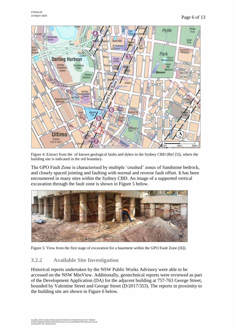
Figure 4: Extract from the of known geological faults and dykes in the Sydney CBD (Ref [5]), where the
building site is indicated in the red boundary.
The GPO Fault Zone is characterised by multiple ‘crushed’ zones of Sandstone bedrock,
and closely spaced jointing and faulting with normal and reverse fault offset. It has been
encountered in many sites within the Sydney CBD. An image of a supported vertical
excavation through the fault zone is shown in Figure 5 below.
Figure 5: View from the first stage of excavation for a basement within the GPO Fault Zone ([6]).
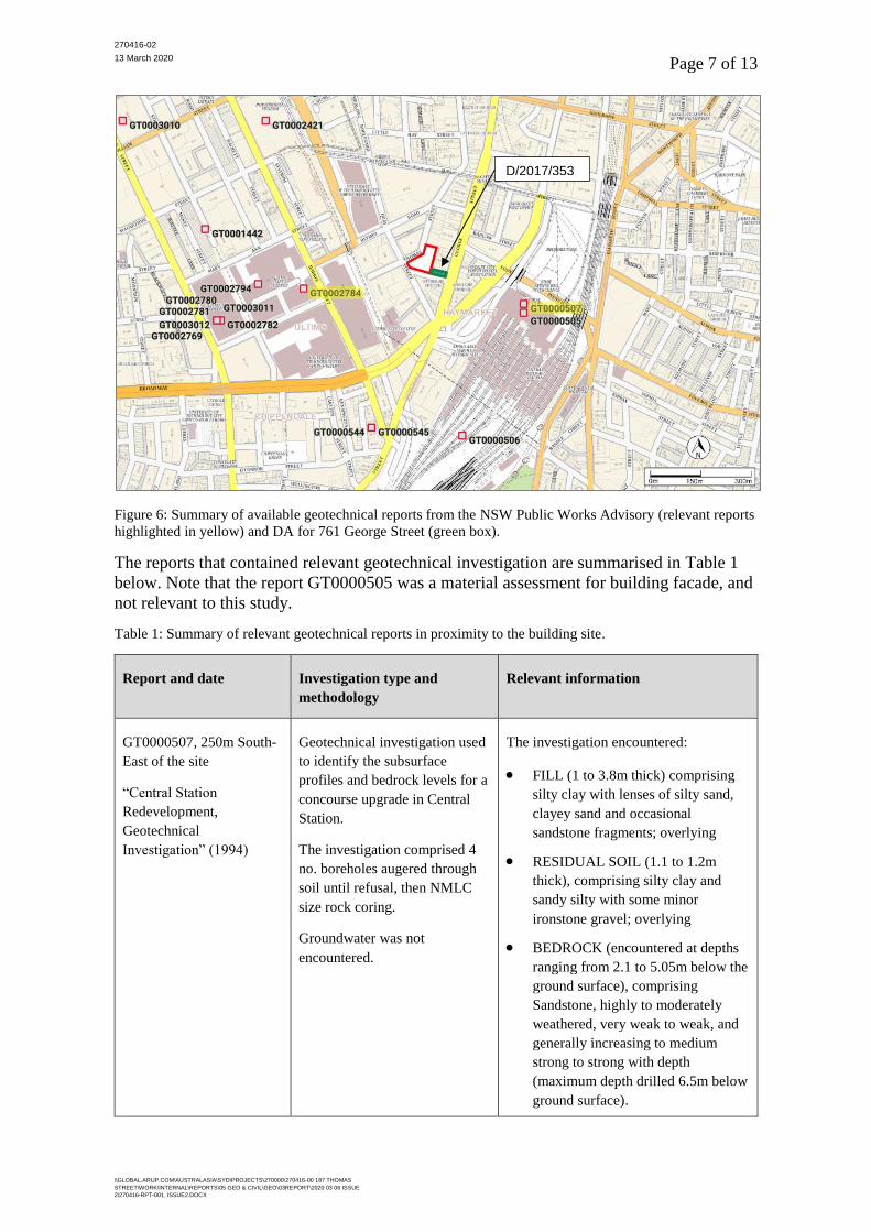
3.2.2 Available Site Investigation
Historical reports undertaken by the NSW Public Works Advisory were able to be
accessed on the NSW MinView. Additionally, geotechnical reports were reviewed as part
of the Development Application (DA) for the adjacent building at 757-763 George Street,
bounded by Valentine Street and George Street (D/2017/353). The reports in proximity to
the building site are shown in Figure 6 below.
270416-02
13 March 2020 Page 7 of 13
\\GLOBAL.ARUP.COM\AUSTRALASIA\SYD\PROJECTS\270000\270416-00 187 THOMAS
STREET\WORK\INTERNAL\REPORTS\05 GEO & CIVIL\GEO\03REPORT\2020 03 06 ISSUE
2\270416-RPT-001_ISSUE2.DOCX
Figure 6: Summary of available geotechnical reports from the NSW Public Works Advisory (relevant reports
highlighted in yellow) and DA for 761 George Street (green box).
The reports that contained relevant geotechnical investigation are summarised in Table 1
below. Note that the report GT0000505 was a material assessment for building facade, and
not relevant to this study.
Table 1: Summary of relevant geotechnical reports in proximity to the building site.
Report and date Investigation type and
methodology
Relevant information
GT0000507, 250m South-
East of the site
“Central Station
Redevelopment,
Geotechnical
Investigation” (1994)
Geotechnical investigation used
to identify the subsurface
profiles and bedrock levels for a
concourse upgrade in Central
Station.
The investigation comprised 4
no. boreholes augered through
soil until refusal, then NMLC
size rock coring.
Groundwater was not
encountered.
The investigation encountered:
• FILL (1 to 3.8m thick) comprising
silty clay with lenses of silty sand,
clayey sand and occasional
sandstone fragments; overlying
• RESIDUAL SOIL (1.1 to 1.2m
thick), comprising silty clay and
sandy silty with some minor
ironstone gravel; overlying
• BEDROCK (encountered at depths
ranging from 2.1 to 5.05m below the
ground surface), comprising
Sandstone, highly to moderately
weathered, very weak to weak, and
generally increasing to medium
strong to strong with depth
(maximum depth drilled 6.5m below
ground surface).
D/2017/353
270416-02
13 March 2020 Page 8 of 13
\\GLOBAL.ARUP.COM\AUSTRALASIA\SYD\PROJECTS\270000\270416-00 187 THOMAS
STREET\WORK\INTERNAL\REPORTS\05 GEO & CIVIL\GEO\03REPORT\2020 03 06 ISSUE
2\270416-RPT-001_ISSUE2.DOCX
Report and date Investigation type and
methodology
Relevant information
GT0002784, 300m South-
West of the site
“Sydney Institute, Ultimo
Campus, Building D
Geotechnical
Investigations” (2003)
Geotechnical investigation used
to identify the subsurface
information for a building
development within the Sydney
Institute campus.
The investigation comprised 4
no. boreholes augered through
soil until refusal, then NMLC
size rock coring.
Groundwater was not
encountered.
The investigation encountered:
• FILL (0.3 to 3.0m thick) comprising
gravelly silty sand with concrete
rubble and metal; overlying
• RESIDUAL SOIL (0.5 to 2.5m
thick) comprising silty clay, clayey
silt with ironstone gravel; overlying
• BEDROCK (encountered at depths
ranging from 2.3 to 3.0m below the
ground surface), comprising
extremely weathered to highly
weathered Sandstone, extremely
weak to very weak and improving to
slightly weathered with depth
(maximum depth drilled 8.75m
below ground surface).
D/2017/353, report No.
E22293 AA_Rev 0,
adjacent to 187 Thomas St
(south-east corner)
“Detailed Site
Investigation Report, 757 –
763 George Street,
Haymarket NSW” (2014)
(Ref [7])
Geotechnical investigation
comprising 2 no. boreholes
augered through soil to refusal,
then NMLC size rock coring to
12.0 and 14.95m below ground
level. 3 no. additional shallow
boreholes for environmental
sampling.
Contamination testing of soil
and groundwater.
Groundwater was not
encountered during drilling,
however estimated to be 6.0m
below ground level from
subsequent sampling.
The generalised subsurface profile in the
report is summarised as:
• FILL (0.7 to 0.8m thick, 7.25m at
BH2) comprising concrete paving,
silty sand/ sandy clay with
construction debris (concrete, bricks,
shale and sandstone); overlying
• RESIDUAL SOIL (approx. 2.2m
thick from BH1) comprising clay /
silty clay with trace rootlets;
overlying
• BEDROCK (encountered at depths
ranging from 3.0 to 7.25m below the
ground surface), comprising
extremely weathered to slightly
weathered Sandstone (maximum
depth drilled 14.95m below ground
surface).
Contaminates were encountered in the
groundwater test results (BTEX/TRH),
and uncontrolled and possibly
contaminated fill were encountered in all
boreholes across the site.
3.2.3 Groundwater
A review of the available groundwater bores within 500m of the site included 48 bores
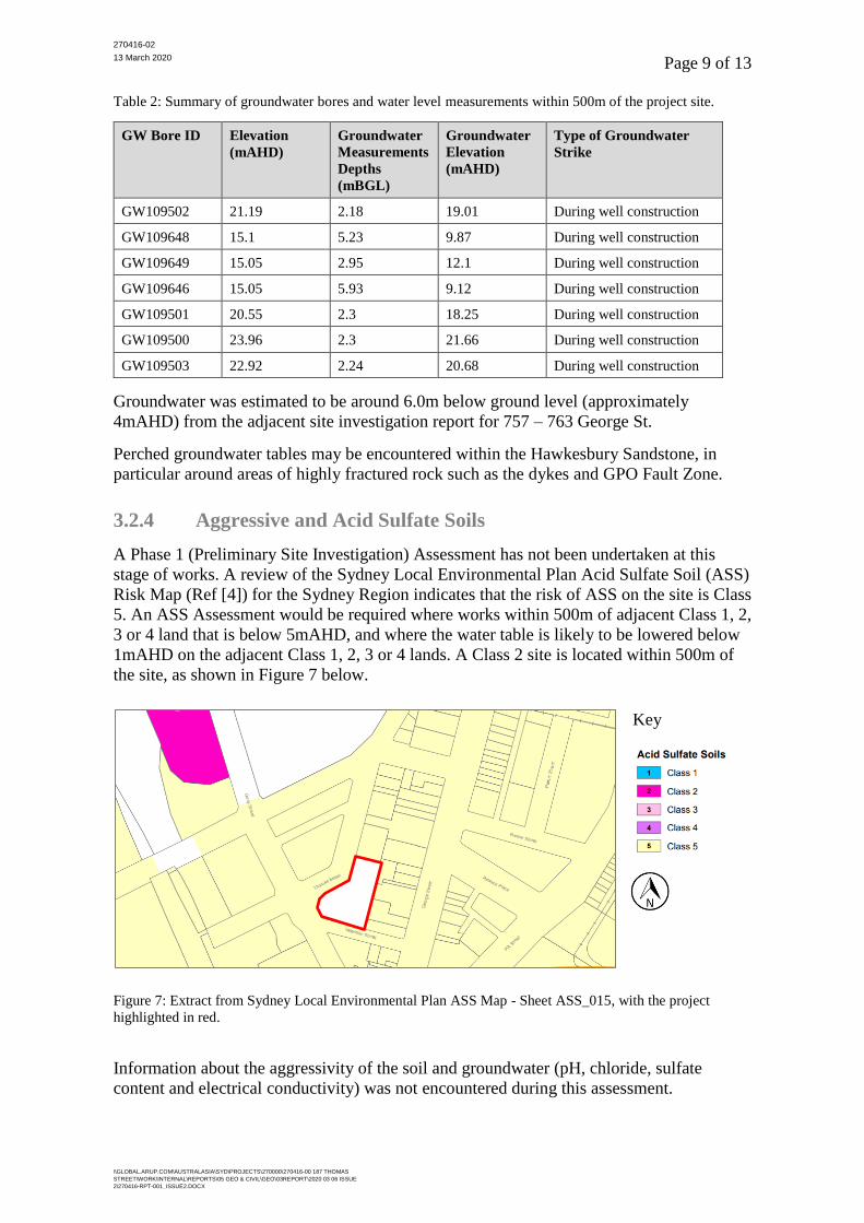
from Water NSW. A summary of the bores with recorded water levels is shown in Table 2
below.
270416-02
13 March 2020 Page 9 of 13
\\GLOBAL.ARUP.COM\AUSTRALASIA\SYD\PROJECTS\270000\270416-00 187 THOMAS
STREET\WORK\INTERNAL\REPORTS\05 GEO & CIVIL\GEO\03REPORT\2020 03 06 ISSUE
2\270416-RPT-001_ISSUE2.DOCX
Table 2: Summary of groundwater bores and water level measurements within 500m of the project site.
GW Bore ID Elevation
(mAHD)
Groundwater
Measurements
Depths
(mBGL)
Groundwater
Elevation
(mAHD)
Type of Groundwater
Strike
GW109502 21.19 2.18 19.01 During well construction
GW109648 15.1 5.23 9.87 During well construction
GW109649 15.05 2.95 12.1 During well construction
GW109646 15.05 5.93 9.12 During well construction
GW109501 20.55 2.3 18.25 During well construction
GW109500 23.96 2.3 21.66 During well construction
GW109503 22.92 2.24 20.68 During well construction
Groundwater was estimated to be around 6.0m below ground level (approximately
4mAHD) from the adjacent site investigation report for 757 – 763 George St.
Perched groundwater tables may be encountered within the Hawkesbury Sandstone, in
particular around areas of highly fractured rock such as the dykes and GPO Fault Zone.
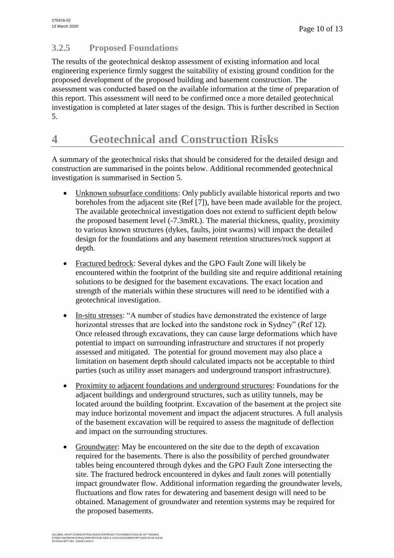
3.2.4 Aggressive and Acid Sulfate Soils
A Phase 1 (Preliminary Site Investigation) Assessment has not been undertaken at this
stage of works. A review of the Sydney Local Environmental Plan Acid Sulfate Soil (ASS)
Risk Map (Ref [4]) for the Sydney Region indicates that the risk of ASS on the site is Class
5. An ASS Assessment would be required where works within 500m of adjacent Class 1, 2,
3 or 4 land that is below 5mAHD, and where the water table is likely to be lowered below
1mAHD on the adjacent Class 1, 2, 3 or 4 lands. A Class 2 site is located within 500m of
the site, as shown in Figure 7 below.
Key
Figure 7: Extract from Sydney Local Environmental Plan ASS Map - Sheet ASS_015, with the project
highlighted in red.
Information about the aggressivity of the soil and groundwater (pH, chloride, sulfate
content and electrical conductivity) was not encountered during this assessment.
270416-02
13 March 2020 Page 10 of 13
\\GLOBAL.ARUP.COM\AUSTRALASIA\SYD\PROJECTS\270000\270416-00 187 THOMAS
STREET\WORK\INTERNAL\REPORTS\05 GEO & CIVIL\GEO\03REPORT\2020 03 06 ISSUE
2\270416-RPT-001_ISSUE2.DOCX
3.2.5 Proposed Foundations
The results of the geotechnical desktop assessment of existing information and local
engineering experience firmly suggest the suitability of existing ground condition for the
proposed development of the proposed building and basement construction. The
assessment was conducted based on the available information at the time of preparation of
this report. This assessment will need to be confirmed once a more detailed geotechnical
investigation is completed at later stages of the design. This is further described in Section
5.
4 Geotechnical and Construction Risks
A summary of the geotechnical risks that should be considered for the detailed design and
construction are summarised in the points below. Additional recommended geotechnical
investigation is summarised in Section 5.
• Unknown subsurface conditions: Only publicly available historical reports and two
boreholes from the adjacent site (Ref [7]), have been made available for the project.
The available geotechnical investigation does not extend to sufficient depth below
the proposed basement level (-7.3mRL). The material thickness, quality, proximity
to various known structures (dykes, faults, joint swarms) will impact the detailed
design for the foundations and any basement retention structures/rock support at
depth.
• Fractured bedrock: Several dykes and the GPO Fault Zone will likely be
encountered within the footprint of the building site and require additional retaining
solutions to be designed for the basement excavations. The exact location and
strength of the materials within these structures will need to be identified with a
geotechnical investigation.
• In-situ stresses: “A number of studies have demonstrated the existence of large
horizontal stresses that are locked into the sandstone rock in Sydney” (Ref 12).
Once released through excavations, they can cause large deformations which have
potential to impact on surrounding infrastructure and structures if not properly
assessed and mitigated. The potential for ground movement may also place a
limitation on basement depth should calculated impacts not be acceptable to third
parties (such as utility asset managers and underground transport infrastructure).
• Proximity to adjacent foundations and underground structures: Foundations for the
adjacent buildings and underground structures, such as utility tunnels, may be
located around the building footprint. Excavation of the basement at the project site
may induce horizontal movement and impact the adjacent structures. A full analysis
of the basement excavation will be required to assess the magnitude of deflection
and impact on the surrounding structures.
• Groundwater: May be encountered on the site due to the depth of excavation
required for the basements. There is also the possibility of perched groundwater
tables being encountered through dykes and the GPO Fault Zone intersecting the
site. The fractured bedrock encountered in dykes and fault zones will potentially
impact groundwater flow. Additional information regarding the groundwater levels,
fluctuations and flow rates for dewatering and basement design will need to be
obtained. Management of groundwater and retention systems may be required for
the proposed basements.
270416-02
13 March 2020 Page 11 of 13
\\GLOBAL.ARUP.COM\AUSTRALASIA\SYD\PROJECTS\270000\270416-00 187 THOMAS
STREET\WORK\INTERNAL\REPORTS\05 GEO & CIVIL\GEO\03REPORT\2020 03 06 ISSUE
2\270416-RPT-001_ISSUE2.DOCX
• Aggressivity: Aggressive soils and groundwater may be encountered on site, which
could impact the design life of buried structures (foundations, retaining structures).
Additional testing of the soil and groundwater would be required to determine if
aggressivity will impact any structural design.
• Acid Sulfate Soils: Due to the proximity of the site to a Class 2 site, and the depth
of disturbance/ potential dewatering during proposed basement construction, an
Acid Sulfate Soil Assessment may need to be undertaken.
5 Recommended Geotechnical Investigation
Geotechnical investigation will be required to inform the design for the foundations and
basements. The building site is likely intersected by dykes and the GPO Fault Zone. The
site is also in proximity interface with potential alluvial/ fluvial deposits to the North and
West of the site (Section 3.2.1). A geotechnical investigation comprising boreholes and
inclined boreholes will be required to identify the type and spatial variability of the
subsurface materials. The quantity, type and depth of the boreholes will need to be further
developed to adequately assess the requirements of the design. In general, the geotechnical
investigation should cover:
• Sufficient geotechnical investigation to provide confidence in the location,
thickness, material strength of the materials for the entire footprint of the building.
This will be critical in determining the location of the known structures (dykes,
faults) across the site. The total depth of investigation should cover all the basement
levels (up to -7.3mRL), with sufficient depth along the entire length of the
foundations, and nominally up to five times the depth of the pile or width of
shallow foundation used to support the superstructure.
• The physical geotechnical investigation should include at a minimum:
o Material type, strength, weathering (for rock);
o Measurement of groundwater encountered and installation of groundwater
monitoring wells;
o In-situ testing (described below); and
o Samples for laboratory testing.
• In-situ testing should include at a minimum:
o Standard Penetration Testing (SPT) within soil units;
o Pump testing, where fractures or groundwater are encountered to assess the
flow rate through fractures within the rock mass, for dewatering and
groundwater recharge assessments;
o Pressure meter testing for the determination of the horizontal stresses in the
rock mass for retention design; and
o Inspection of the rock jointing and structure.
• Laboratory testing should include at a minimum:
o Classification testing for soil units encountered (Atterberg Limits, Particle
Size Distribution, Moisture Condition); and
270416-02
13 March 2020 Page 12 of 13
\\GLOBAL.ARUP.COM\AUSTRALASIA\SYD\PROJECTS\270000\270416-00 187 THOMAS
STREET\WORK\INTERNAL\REPORTS\05 GEO & CIVIL\GEO\03REPORT\2020 03 06 ISSUE
2\270416-RPT-001_ISSUE2.DOCX
o Rock strength testing (Uniaxial compressive strength [UCS] and Point Load
Index [PLI]).
• Where groundwater or perched groundwater tables are encountered, additional
long-term monitoring or testing may be required. A qualified geotechnical engineer
should be engaged to assess the required geotechnical investigations as per the
detailed design.
Contamination was noted in the investigation report for 757 – 763 George Street (Ref [7]).
An environmental and contamination investigation should be undertaken by a qualified
environmental engineer for the site and include at a minimum:
• Identification of contamination;
• Presence of aggressive soils and/or groundwater; and
• Presence of Acid Sulfate Soils (ASS).
6 References
[1] City of Sydney Development Applications, accessed 18 January 2020,
<online2.cityofsydney.nsw.gov.au>
[2] NSW Statewide Seamless Geology, Version 1.1, 1:25,000 scale Surface
Geology, accessed via NSW MinView 18 January 2020,
<www.minview.geoscience.nsw.gov.au>
[3] NSW Seatewide Seamless Geology, Version 1.1, 1:25,000 scale Great Soil
Group Outcrop, accessed via NSW MinView 18 January 2020,
<www.minview.geoscience.nsw.gov.au>
[4] Sydney Local Environmental Plan 2012 Acid Sulfate Risk Map, NSW
Legislation, Sheet ASS_015 (last updated 29 November 2019)
[5] Pells, P.J. N., Braybrooke, J.C., Och, D.J. (2004). “Geological faults and dykes
in the Sydney CBD”
[6] Oliveria, D. and Chan, G. (2016). “Ground control for a deep basement
excavation in Sydney’s GPO fault zone”
[7] “Detailed Site Investigation Report, 757 – 763 George Street, Haymarket
NSW” (2014), Report No E22293 AA_Rev 0, Environmental
Investigations Australia, accessed through City of Sydney
Development Application Portal (application number D/2017/353)
7 Assumptions and Limitations
This report has been prepared by Arup for Greaton Development and may only be used
and relied on by Greaton Development for the purpose agreed between Arup and Greaton
Development as set out in in the Proposal Letter dated 27 November 2019, “187 Thomas
Street –Support”.
Arup otherwise disclaims responsibility to any person other than Greaton Development
arising in connection with this report. Arup also excludes implied warranties and
conditions, to the extent legally permissible.
270416-02
13 March 2020 Page 13 of 13
\\GLOBAL.ARUP.COM\AUSTRALASIA\SYD\PROJECTS\270000\270416-00 187 THOMAS
STREET\WORK\INTERNAL\REPORTS\05 GEO & CIVIL\GEO\03REPORT\2020 03 06 ISSUE
2\270416-RPT-001_ISSUE2.DOCX
The services undertaken by Arup in connection with preparing this report were limited to
those specifically detailed in the report and are subject to the scope limitations set out in
the report.
The opinions, conclusions and any recommendations in this report are based on conditions
encountered and information reviewed at the date of preparation of the report. Arup has no
responsibility or obligation to update this report to account for events or changes occurring
subsequent to the date that the report was prepared.
The opinions, conclusions and any recommendations in this report are based on
assumptions made by Arup described in this report. Arup disclaims liability arising from
any of the assumptions being incorrect.
Arup has prepared this report based on information provided by Greaton Development and
others who provided information to Arup (including Government authorities), which Arup
has not independently verified or checked beyond the agreed scope of work. Arup does not
accept liability in connection with such unverified information, including errors and
omissions in the report which were caused by errors or omissions in that information.
Site conditions (including the presence of hazardous substances and/or site contamination)
may change after the date of this report. Arup does not accept responsibility arising from,
or in connection with, any change to the site conditions. Arup is also not responsible for
updating this report if the site conditions change.
Yours sincerely
Jillian Bardos
Senior Geotechnical Engineer