Introducing WorldView: DigitalGlobe’s Next Generation...
28
11 April 2007 1 Digital Globe, Inc. Confidential An Imaging and Information Company Introducing WorldView: DigitalGlobe’s Next Generation System Introducing WorldView: DigitalGlobe’s Next Generation System
Transcript of Introducing WorldView: DigitalGlobe’s Next Generation...

11 April 2007 1 Digital Globe, Inc. Confidential An Imaging and Information Company
Introducing WorldView: DigitalGlobe’s Next Generation System
Introducing WorldView: DigitalGlobe’s Next Generation System

11 April 2007 2 Digital Globe, Inc. Confidential An Imaging and Information Company
An Enduring Satellite Constellation
An Enduring Satellite Constellation
DigitalGlobe is in a unique position in the high resolution commercial imagery industry• QuickBird satellite in optimal health;
- Expected to remain in full operations until mid-to-late 2009• WorldView-1 (WV-1) satellite to be launched in mid 2007• WorldView-2 (WV-2) satellite to be launched in 2008
QuickBird
DigitalGlobe Imagery Library
Year 2003 2004 2005 2006 2007 2008 2009
By 3rd quarter 2007, DigitalGlobe’sWorldView-1 and QuickBird spacecraft will be capable of collecting more than 500,000 km2/day of sub-meter imagery
By 1st quarter 2009, with the addition of WorldView-2, the constellation will be capable of collection 1,000,000 km2/day
WV-1
WV-2
2002 2010

11 April 2007 3 Digital Globe, Inc. Confidential An Imaging and Information Company
ProgramStartAug.
BATC Under
ContractOct.
SatellitePrelim.DesignReview (PDR)
Jan
SatelliteEnv
TestingComplete
April
SensorSubsystemDelivery to
BATCJuly
InstrumentIntegration
into BusDec
LAUNCHJuly 1, 2007
FOCQ3
WorldView-1 and WorldView-2 Satellite Timelines
WorldView-1 and WorldView-2 Satellite Timelines
Q3 Q4 Q1 Q2 Q3 Q4 Q1 Q2 Q3 Q4 Q1 Q2 Q3 Q4
2003 2004 2005 2006
Q1 Q2 Q3 Q4
2007
Q1 Q2 Q3 Q4
2008
Q1 Q2
2009
SatelliteCriticalDesignReview (CDR)June
OBADelivery
toBATCSept
LAUNCHDec
Q3 Q4 Q1 Q2 Q3 Q4 Q1 Q2 Q3 Q4 Q1 Q2 Q3 Q4
2003 2004 2005 2006
Q1 Q2 Q3 Q4
2007
Q1 Q2 Q3 Q4
2008
Q1 Q2
2009
ProgramStartAug.
BATCUnder
ContractOct
Bus DeltaPDRQ1
WV-110Inst
DeliveryTo
BATCQ1
BusI&T
CompleteQ1
BusComplete
Q2
SpacecraftComplete
Q3
FOCQ1
WorldView-2
WorldView-1
WV-60TelescopeAssembly
and Bus Structure
IntegrationStart Dec
Bus DeltaCDRQ2

11 April 2007 4 Digital Globe, Inc. Confidential An Imaging and Information Company
Instrument to Bus
IntegrationDec 06 –
mid-Jan 07
Pre-Environment
TestingMid-Jan –Early Feb
S/C Environmental
TestingEarly Feb –
mid April
Solar Array
Deploy, Prop
Module TestFirst Halfof
April
Post-EnvTestLast Half of
April
SpacecraftCompleteFirst Halfof May
Pack/Satellite Ready to Ship
First Halfof May
LAUNCHJuly 1, 2007
Verificationand
Calibration
WorldView-1 Satellite Timeline: Activities to Launch
WorldView-1 Satellite Timeline: Activities to Launch

11 April 2007 5 Digital Globe, Inc. Confidential An Imaging and Information Company
Comparative ConstellationSchedules
Comparative ConstellationSchedules
• Solid line: Design life• Hatched line: Expected life

11 April 2007 6 Digital Globe, Inc. Confidential An Imaging and Information Company
DigitalGlobe Constellation
Direct Tasking
Direct Downlink
GeoEye Constellation
Direct Tasking Direct Downlink
OrbView-3 QuickBird
IKONOS
WorldView-1
With Dialog with DG HQ
GeoEye 1
With Dialog with
GeoEye HQ
WorldView-2
Third Generation
Constellation
No Follow-On Satellites
Comparative ConstellationCapabilities
Comparative ConstellationCapabilities

11 April 2007 7 Digital Globe, Inc. Confidential An Imaging and Information Company
DG Satellite ComparisonDG Satellite Comparison
QuickBird WorldView-1 WorldView-2
1 day2 days3.5 daysAvg Revisit (to 40° latitude target)4X+ per satellite1 XMonoscopic Area Coverage
12K Line Rate:6 x 55 km (1/2 deg cell)3 x 110 km (1 deg cell)2 x 220 km (2 deg cell)24K Line Rate:9 x 55 km (1/2 deg cell)5 x 110 km (1 deg cell)3 x 220 km (2 deg cell)
3 x 55 km (0.5 deg cell)2 x 110 km (1 deg cell)1 x 220 km (2 deg cell)
1x16 km(Single Scene)
Single-Pass Stereoscopic Coverage,<30° off-nadir
Virtual Ground Terminal (VGT)320 Mbps137 Gbits
Reaction Wheels
16.5 km
2.4 m
0.61 mPan / 4 MS
1,100 kg (2400 lb)450 km
2,800 kg (6200 lb)2,500 kg (5500 lb)Weight Class
16.4 km17.7 kmSwath Width
0.5 m(native: 0.46 m**)
0.5 mPanchromatic Resolution (nadir)
2.0 m (native 1.85 m**)
N/AMultispectral Resolution (nadir)
Pan / 8 MS PanSpectral Characteristics
Direct Downlink, VGTRapid Delivery Options800 MbpsWideband Link Rate
1600 Gbits (2200 Beginning of Life (BOL))Onboard StorageControl Moment GyrosPrimary Attitude Control Mechanism
770 km496kmOperational Altitude
** > 0.5 m PAN GSD imagery is only available to customers with a waiver for the resolution restriction; this requires a government-to-government agreement.Note: for WV-2, the 24K PAN line rate is available with a 3K MS line rate, which results in PAN and MS resolutions of 0.5 m and 4 m, respectively.

11 April 2007 8 Digital Globe, Inc. Confidential An Imaging and Information Company
• 60cm Aperture Telescope• 0.5m Nadir GSD at 496 km• Pan only, Bi-Directional Scan• 2 Terabit Recorder• 800 Mpbs Downlink
• Control Moment Gyros• Large Propulsion Systems• 2 Single Axis Solar Array Wings• Star Tracker, SIRU, GPS
WorldView-1 SatelliteOverview
WorldView-1 SatelliteOverview

11 April 2007 9 Digital Globe, Inc. Confidential An Imaging and Information Company
WorldView-1 SatelliteIntegration (1 of 3)
WorldView-1 SatelliteIntegration (1 of 3)

11 April 2007 10 Digital Globe, Inc. Confidential An Imaging and Information Company
WorldView-1 SatelliteIntegration (2 of 3)
WorldView-1 SatelliteIntegration (2 of 3)

11 April 2007 11 Digital Globe, Inc. Confidential An Imaging and Information Company
WorldView-1 SatelliteIntegration (3 of 3)
WorldView-1 SatelliteIntegration (3 of 3)

11 April 2007 12 Digital Globe, Inc. Confidential An Imaging and Information Company
First Stage Second Stage Solid Rocket Motors (9)
Interstage Payload Adapter Fitting Fairing
WorldView-1 Satellite: Launch Vehicle
WorldView-1 Satellite: Launch Vehicle

11 April 2007 13 Digital Globe, Inc. Confidential An Imaging and Information Company
• 110cm Aperture Telescope• <0.5m Nadir GSD at 770 km• Pan & 8 MS, Bi-Directional Scan• 2 Terabit Recorder• 800 Mpbs Downlink
• Control Moment Gyros• Large Propulsion Systems• 2 Single Axis Solar Array Wings• Star Tracker, SIRU, GPS
WorldView-2 SatelliteOverview
WorldView-2 SatelliteOverview

11 April 2007 14 Digital Globe, Inc. Confidential An Imaging and Information Company
Optical Telescope
WV-1 WV-2Outer Barrel Assembly w/Recallable Aperture
Cover
Sun Shade w/one-time Deployable Aperture Cover
Focal Plane Unit
Spacecraft Bus
Propulsion Module
CMG Module
WorldView-1 and 2: Common Spacecraft Bus
WorldView-1 and 2: Common Spacecraft Bus

11 April 2007 15 Digital Globe, Inc. Confidential An Imaging and Information Company
WorldView-2 Spectral BandsWorldView-2 Spectral Bands
450 800
400 450
450 510
580
585 625
630 690
705 745
770 895
860 1040
510
300 400 500 600 700 800 900 1000 1100
Wavelengths (nm)
Panchromatic
Coastal
Blue
Green
Yellow
Red
Red Edge
NIR1
NIR2
Band
s
QuickBird Legacy Band
New Spectral Band
• WorldView-2 has a “visible” panchromatic band (Narrower than QuickBird) • WorldView-2 satellite incorporates the industry standard four multispectral bands
-- Red, Blue, Green, Near-Infrared• Four additional (NEW) bands
-- Coastal Blue, Yellow, Red Edge, Longer Wave Near-Infrared (NIR2).

11 April 2007 16 Digital Globe, Inc. Confidential An Imaging and Information Company
WorldView-2 Spectral Bands:Applications (1 of 2)
WorldView-2 Spectral Bands:Applications (1 of 2)
Coastal Band (400 - 450 nm): • This band supports vegetation identification and analysis, and supports
bathymetric studies based upon its chlorophyll and water penetration characteristics. Also, this band is subject to atmospheric scattering and will be used to investigate atmospheric correction techniques.
Yellow Band (585 - 625 nm):• Used to identify "yellow-ness" characteristics of targets, important for vegetation
applications. Also, this band will assist in the development of "true-color"hue correction for human vision representation.
Red Edge Band (705 - 745 nm):• Aids in the analysis of vegetative condition. Directly related to plant health
revealed through chlorophyll production.
Near Infrared (IR) 2 Band (860 - 1040 nm):• This band overlaps the NIR 1 band but is less affected by atmospheric influence.
It supports vegetation analysis and biomass studies.

11 April 2007 17 Digital Globe, Inc. Confidential An Imaging and Information Company
WorldView-2 Spectral Bands:Applications (2 of 2)
WorldView-2 Spectral Bands:Applications (2 of 2)
• The addition of a second NIR 2 band allows more effective assessment of disturbed soil, which is a good sign of human movement (e.g., troops, vehicles, etc.), and buried objects (e.g., landmines, etc.)
• The new Yellow, Red Edge, and NIR 2 bands significantly improve the ability to discriminate camouflage from vegetation.
• Added spectral diversity provides ability to perform change detection and surveillance, camouflage detection, mission planning and simulation.
• Together, the six non-NIR multispectral bands can be used to create a natural color image that matches the human visual response. – This is not possible with the four QuickBird MS bands.
• The WorldView-2 panchromatic band has a filter to create a bandpass of 450-800 nm as opposed to QuickBird which is sensitive out to 900 nm.– This shorter wavelength cutoff makes the WorldView-2 panchromatic band
more compatible to other satellite systems and aerial imagery.

11 April 2007 18 Digital Globe, Inc. Confidential An Imaging and Information Company
• Typical values, without control, using only satellite data (i.e., attitude and ephemeris)
• WorldView-1 and -2 are being built to a 12.2 m CE90 accuracy specification– Expected accuracies are significantly better– Performance goal of ~5 m for WorldView-1 and ~7 m for WorldView-2
WorldViewGeolocational Accuracies
WorldViewGeolocational Accuracies
Initial Attitude/Ephemeris
(Available Immediately After Downlink)
Refined Attitude/Ephemeris (Available Within 2 hours of Pass)
QuickBird N/A 23 m
WorldView-1 19 m 5 m
WorldView-2 22 m 7 m

11 April 2007 19 Digital Globe, Inc. Confidential An Imaging and Information Company
Very High (Control Moment Gyros, High Altitude)
Moderate (Reaction Wheels, High Altitude)
Moderate (Reaction Wheels, High Altitude)
Moderate (Reaction Wheels, Low Altitude)
Satellite Agility
1722.31Relative satellite Agility (acceleration)[Using QuickBird as Baseline]
WV-1 = 496 kmWV-2 = 770 km
684 km682 km450 kmOrbit Altitude
2015 (WV-2)7 years from launch, Fully Redundant
20072009Expected Lifetime
DDL1, VGTDDLDirect Downlink (DDL)Virtual Ground Terminal (VGT)
Delivery Options
1-2 Days
800 Gb
740 Mpbs
15.2 km / 231 km2
0.5 m Panchromatic1
2.0 m Multispectral(4 bands)
To be launched 2007/08
GeoEyeGeoEye-1
2-3 Days
64 Gb
320 Mbps
11 km / 121 km2
0.82m Panchromatic 3.2m Multispectral
(4 Bands)
1999
Space ImagingIKONOS
2-3 Days
128 Gb
320 Mbps
16.5 km / 272 km2
0.61m Panchromatic2.4m Multispectral
(4 Bands)
2001
DigitalGlobeQuickBird
1,600 Gb (2,200 Gb BOL)On-Board Storage
DailySatellite Revisit (<1m GSD at Mid Lat.)
WV-1 = 17.7 km / 313 km2
WV-2 = 16.4 km / 269 km2Nadir swath width / scene area
WV-1 to be launched 2007WV-2 to be launched 2008
Launched
800 MbpsDownlink Data Rate
0.5 m Panchromatic2.0 m Multispectral** (8 Bands for WV-2)
Resolution
DigitalGlobeWorldView-1 and -2Characteristic
Industry Satellite ComparisonIndustry Satellite Comparison
1 0.5 m resolution PAN imagery is only available immediately to customers with a waiver for the 24 hour restriction, which restricts the PAN spatial resolution to 0.82 m.**Note: the WV-2, 24K PAN line rate is available with the 3K MS line rate, which results in PAN and MS resolutions of 0.5 m and 4 m, respectively.
GeoEye-1 24 K PAN line rate is PAN only.

11 April 2007 20 Digital Globe, Inc. Confidential An Imaging and Information Company
Revisit At 1 meter Resolution40 Deg Latitude North
Revisit At 1 meter Resolution40 Deg Latitude North
Ikonos Ikonos ~700 km Field of Regard= 3+ Day Revisit
WorldView-2 ~1,850 km Field of Regard= ~1 Day Revisit770 km altitude
682 km altitude
Ikonos 1 meter WV 1 meter
WorldView-2
Field of Regard
496 km altitudeWorldView-1 ~ 1,100 km
Field of Regard= < 2 Day Revisit
WorldView-1

11 April 2007 21 Digital Globe, Inc. Confidential An Imaging and Information Company
Example:Cross-Track Distance from Tehran to Baghdad ~600km:GeoEye-1 slew time: 32 secIKONOS slew time: 29 secWorldView-1 & 2 slew times: 14 sec
Cross Track Distance = ~600km
Baghdad
Tehran
Higher agility minimizes slew time between targets
Slew Time ComparisonSlew Time Comparison

11 April 2007 22 Digital Globe, Inc. Confidential An Imaging and Information Company
• WorldView-1 and WorldView-2’s Control Moment Gyros (CMGs) provide an acceleration >10X better than competition
• Better Agility:– Improves collection efficiency– Permits rapid collection of point targets– Increases imaging capacity
20 sec
200 km
GeoEye-1
7 sec
200 km
WorldView-1
7 sec
200 km
WorldView-2
18 sec
200 km
IKONOS
Agility ComparisonAgility Comparison

11 April 2007 23 Digital Globe, Inc. Confidential An Imaging and Information Company
Higher agility provides superior collection of separated Point Targets
Collection of Point Targets (1 of 2)
Collection of Point Targets (1 of 2)
WorldView-2
Point Target Rate 2.7X GeoEye-1

11 April 2007 24 Digital Globe, Inc. Confidential An Imaging and Information Company
Collection of Point Targets (2 of 2)
Collection of Point Targets (2 of 2)
Higher agility provides larger point target collection rates for all target spacings
Note: WV-2 and GE-1 at 24K

11 April 2007 25 Digital Globe, Inc. Confidential An Imaging and Information Company
WorldView-2Area Collection Rate
2.2X GeoEye-13.4X IKONOS
Example:
Collection of 1-deg cells (110km strip lengths)
5 Minute Window Collection Yields:
IKONOS: 10,000 km2
WorldView-1: 25,000 km2
WorldView-2, 24K: 34,000 km2
GeoEye-1, 24K: 15,500 km2
Higher agility provides better area collection rates
Area Collection RatesArea Collection Rates

11 April 2007 26 Digital Globe, Inc. Confidential An Imaging and Information Company
WorldView-2 Contiguous Area Rate
2.3X GeoEye-1
Higher agility provides faster collection of 1 degree cells
Contiguous Area CollectionContiguous Area Collection

11 April 2007 27 Digital Globe, Inc. Confidential An Imaging and Information Company
WorldView Systems outperform GeoEye-1 in every category
Relative PerformanceRelative Performance
Collection Comparison
0.0
0.5
1.0
1.5
2.0
2.5
3.0
Points Sustained Area 1° Cell ROIRel
ativ
e to
Geo
Eye-
1 C
apab
ility
IKONOS WorldView -1 WorldView -2 GeoEye-1
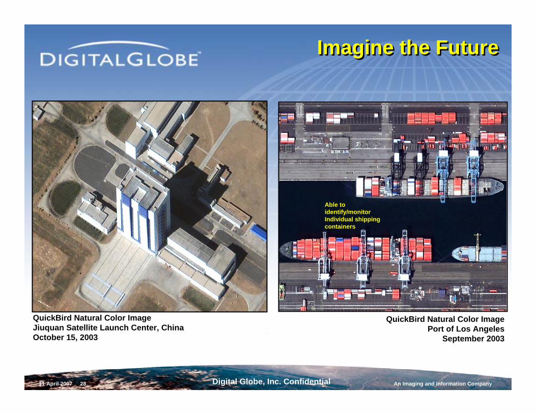
11 April 2007 28 Digital Globe, Inc. Confidential An Imaging and Information Company
Imagine the FutureImagine the Future
QuickBird Natural Color ImagePort of Los Angeles
September 2003
Able to identify/monitor Individual shipping containers
QuickBird Natural Color ImageJiuquan Satellite Launch Center, ChinaOctober 15, 2003