Intrinsic vulnerability mapping for small mountainous...
13
Intrinsic vulnerability mapping for small mountainous karst aquifers, implementation of the new PaPRIKa method to Western Pyrenees (France) F. Huneau a, b, ⁎, J. Jaunat c , K. Kavouri d , V. Plagnes d , F. Rey c , N. Dörfliger e a Université de Corse Pascal Paoli, Faculté des Sciences et Techniques, Laboratoire d'Hydrogéologie, Campus Grimaldi, BP 52, F-20250, Corte, France b CNRS, UMR 6134, SPE, F-20250, Corte, France c CETRA, 12 route de l'Artisanat, F-64110, Laroin, France d Université Pierre et Marie Curie—Paris VI, UMR CNRS 7619 Sisyphe, 4 place Jussieu, cc 105, F-75252, Paris, France e BRGM Direction Eau, Environnement et Ecotechnologies, 3 avenue C. Guillemin, BP 36009, F-45060 Orléans Cedex 2, France abstract article info Article history: Received 18 June 2012 Received in revised form 29 March 2013 Accepted 30 March 2013 Available online 16 April 2013 Keywords: Groundwater Carbonate and karst aquifer Protection Vulnerability mapping Mountain Karst The new intrinsic vulnerability mapping method PaPRIKa is proposed as a tool to assess groundwater protec- tion of small karst systems exploited for drinking water supply purposes in the French Pyrenees. The specific characteristics of the discontinuous carbonate aquifers of mountainous areas are here considered and taken into account into the implementation of the methodology. The Orbe site from the French Western Pyrenees area is chosen as a test site because of the relatively well known structure and behavior of the aquifer system. Steep slopes, extremely developed dissolution features, thin soils and strong dipping of geological formations are the main points to be considered. PaPRIKa method appears as a tool to assess and illustrate both the resource and source vulnerability according to the site specificities provided that appropriate field observa- tions at a relatively high density are carried out. The vulnerability of the resource was assessed for the entire catchment area, while source-orientated mapping was attempted for the catchment area of the main capture work used for drinking water supply. © 2013 Elsevier B.V. All rights reserved. 1. Introduction In the French Pyrenees groundwater from carbonate rocks are considered as a huge potential resource for water supply to satisfy drinking water needs. In the coming years, these resources will be necessary as a substitution to surface water resources which are con- stantly decreasing because of the intense agricultural activity within the area and which quality is more and more unable to meet European drinking water standards (Rey, 2007). The development of carbonate aquifer groundwater is planned through the capture of many springs scattered over large areas and mainly concerns the South of the Béarn Region and more precisely the area of the “Chaînons Béarnais”, here considered as a test zone. The discontinuous structure of these reservoirs is a main obstacle to the development and exploita- tion of groundwater, but since no other aquifer can be tapped in these areas, many communities have decided to improve their knowl- edge of the main springs of the region. A few of them are already used for drinking water supply, but problems linked to the lack of proper management can lead in some cases to water supply disruption because of quality problems especially during strong rain episodes. The French regulation on potable water quality inherited from the European Water Framework Directive 2000/60/CE and dated from the 23rd October 2000 forces administrations in charge of groundwa- ter management and distribution to pay attention to resource protec- tion. Efficient management is strongly correlated to the proper protection perimeter definition around springs and proactive regula- tion of land uses over the spring's catchment area (“impluvium”). For water supply managers the objectives are to minimize the poten- tial cost of water treatment and to guaranty the continuous delivery of good quality water to consumers. Vulnerability mapping appears as a tool to assess karst aquifer vulnerability and has been proposed as a basis for protection zoning and land-use planning (Daly et al., 2002; Zwahlen, 2004). Eight main karst groundwater vulnerability mapping methods have been used up to now: EPIK (Dörfliger and Zwahlen, 1998; Dörfliger et al., 1999), REKS (Malik and Svasta, 1999); RISKE (Pételet-Giraud et al., 2000); RISKE 2 (Plagnes et al., 2005), PI (Goldscheider, 2005) and the Slovene approach (Ravbar and Goldscheider, 2007); KARSTIC (Davis et al., 2002) and the COP and COP + K method (Vias et al., 2002; Andreo et al., 2009). However resulting vulnerability maps based on these different methods on the same test site often leads to significant differences without carrying out treatment to compare them; the major difference is essentially due to the way of considering the variables related to overlaying layers and the respective applied weighting systems. Engineering Geology 161 (2013) 81–93 ⁎ Corresponding author at: Université de Corse Pascal Paoli, Faculté des Sciences et Techniques, Laboratoire d'Hydrogéologie, Campus Grimaldi, BP 52, F-20250 Corte, France. Tel.: +33 4 95 45 00 26; fax: +33 4 20 20 23 73. E-mail address: [email protected] (F. Huneau). 0013-7952/$ – see front matter © 2013 Elsevier B.V. All rights reserved. http://dx.doi.org/10.1016/j.enggeo.2013.03.028 Contents lists available at SciVerse ScienceDirect Engineering Geology journal homepage: www.elsevier.com/locate/enggeo
Transcript of Intrinsic vulnerability mapping for small mountainous...
Engineering Geology 161 (2013) 81–93
Contents lists available at SciVerse ScienceDirect
Engineering Geology
j ourna l homepage: www.e lsev ie r .com/ locate /enggeo
Intrinsic vulnerability mapping for small mountainous karst aquifers,implementationof the new PaPRIKa method to WesternPyrenees (France)F. Huneau a,b,⁎, J. Jaunat c, K. Kavouri d, V. Plagnes d, F. Rey c, N. Dörfliger e
a Université de Corse Pascal Paoli, Faculté des Sciences et Techniques, Laboratoire d'Hydrogéologie, Campus Grimaldi, BP 52, F-20250, Corte, Franceb CNRS, UMR 6134, SPE, F-20250, Corte, Francec CETRA, 12 route de l'Artisanat, F-64110, Laroin, Franced Université Pierre et Marie Curie—Paris VI, UMR CNRS 7619 Sisyphe, 4 place Jussieu, cc 105, F-75252, Paris, Francee BRGM Direction Eau, Environnement et Ecotechnologies, 3 avenue C. Guillemin, BP 36009, F-45060 Orléans Cedex 2, France
⁎ Corresponding author at: Université de Corse PascaTechniques, Laboratoire d'Hydrogéologie, Campus GrFrance. Tel.: +33 4 95 45 00 26; fax: +33 4 20 20 23 7
E-mail address: [email protected] (F. Huneau).
0013-7952/$ – see front matter © 2013 Elsevier B.V. Allhttp://dx.doi.org/10.1016/j.enggeo.2013.03.028
a b s t r a c t
a r t i c l e i n f oArticle history:Received 18 June 2012Received in revised form 29 March 2013Accepted 30 March 2013Available online 16 April 2013
Keywords:GroundwaterCarbonate and karst aquiferProtectionVulnerability mappingMountainKarst
The new intrinsic vulnerability mapping method PaPRIKa is proposed as a tool to assess groundwater protec-tion of small karst systems exploited for drinking water supply purposes in the French Pyrenees. The specificcharacteristics of the discontinuous carbonate aquifers of mountainous areas are here considered and takeninto account into the implementation of the methodology. The Orbe site from the French Western Pyreneesarea is chosen as a test site because of the relatively well known structure and behavior of the aquifer system.Steep slopes, extremely developed dissolution features, thin soils and strong dipping of geological formationsare the main points to be considered. PaPRIKa method appears as a tool to assess and illustrate both theresource and source vulnerability according to the site specificities provided that appropriate field observa-tions at a relatively high density are carried out. The vulnerability of the resource was assessed for the entirecatchment area, while source-orientated mapping was attempted for the catchment area of the main capturework used for drinking water supply.
© 2013 Elsevier B.V. All rights reserved.
1. Introduction
In the French Pyrenees groundwater from carbonate rocks areconsidered as a huge potential resource for water supply to satisfydrinking water needs. In the coming years, these resources will benecessary as a substitution to surface water resources which are con-stantly decreasing because of the intense agricultural activity withinthe area andwhich quality is more andmore unable tomeet Europeandrinking water standards (Rey, 2007). The development of carbonateaquifer groundwater is planned through the capture of many springsscattered over large areas and mainly concerns the South of theBéarn Region and more precisely the area of the “Chaînons Béarnais”,here considered as a test zone. The discontinuous structure ofthese reservoirs is a main obstacle to the development and exploita-tion of groundwater, but since no other aquifer can be tapped inthese areas, many communities have decided to improve their knowl-edge of the main springs of the region. A few of them are already usedfor drinking water supply, but problems linked to the lack of propermanagement can lead in some cases to water supply disruptionbecause of quality problems especially during strong rain episodes.
l Paoli, Faculté des Sciences etimaldi, BP 52, F-20250 Corte,3.
rights reserved.
The French regulation on potable water quality inherited from theEuropean Water Framework Directive 2000/60/CE and dated fromthe 23rd October 2000 forces administrations in charge of groundwa-ter management and distribution to pay attention to resource protec-tion. Efficient management is strongly correlated to the properprotection perimeter definition around springs and proactive regula-tion of land uses over the spring's catchment area (“impluvium”).For water supply managers the objectives are to minimize the poten-tial cost of water treatment and to guaranty the continuous delivery ofgood quality water to consumers.
Vulnerability mapping appears as a tool to assess karst aquifervulnerability and has been proposed as a basis for protection zoningand land-use planning (Daly et al., 2002; Zwahlen, 2004).
Eight main karst groundwater vulnerability mapping methodshave been used up to now: EPIK (Dörfliger and Zwahlen, 1998;Dörfliger et al., 1999), REKS (Malik and Svasta, 1999); RISKE(Pételet-Giraud et al., 2000); RISKE 2 (Plagnes et al., 2005), PI(Goldscheider, 2005) and the Slovene approach (Ravbar andGoldscheider, 2007); KARSTIC (Davis et al., 2002) and the COP andCOP + K method (Vias et al., 2002; Andreo et al., 2009). Howeverresulting vulnerability maps based on these different methods onthe same test site often leads to significant differences withoutcarrying out treatment to compare them; the major difference isessentially due to the way of considering the variables related tooverlaying layers and the respective applied weighting systems.
82 F. Huneau et al. / Engineering Geology 161 (2013) 81–93
Introduced by Kavouri et al. (2011), PaPRIKa is a new and improvedintrinsic vulnerabilitymappingmethod derived frompreviousmethodsspecially dedicated to karst aquifers. PaPRIKa method gives systemati-cally two vulnerability maps: the resource-vulnerability map to beused as a tool for stakeholders in order to control diffuse pollution andto prevent further deterioration of the environment, and the sourcecatchment vulnerability map to prevent contamination from accidentalpollution and to help delineating the protection zones for publicdrinking-water supplies capture works in karst aquifers.
PaPRIKamethodwas developed having in mind the objective to beaffordable in terms of costs, to be technically feasible for consultinghydrogeologists and stakeholders, and to use data easily availablesuch as geological and soil maps, groundwater databases, field obser-vations and technical reports.
The Orbe karst system is one of the nine pilot sites in France wherethis method was tested and improved. This site can be considered as anedge case and provides an interesting field of application for the vulnera-bility mapping due to its specificities: the catchment's area is particularlysmall (5 km2), the epikarst and the karst network are well developed.The karst system is authigenic, disconnected from any river stream(Rey, 2007). The Orbe aquifer is exploited for the drinking water supplyof the city of Arette in conjunction with alluvial groundwater resources.
The goal of this study is to implement the new PaPRIKa methodol-ogy to the very specific conditions of small scale mountainous karstaquifers and to discuss the potential adjustments necessary to use itadequately in such conditions.
Table 1Indexes to evaluate the protectiveness (P) of cover layers (from Kavouri et al., 2011).
Index of sinking-streams catchment area characterization (Ca)
Catchment area Characterizations
Ca1 Highly permeable formations: sand, gravelsCa2 Moderately permeable formations: altered gCa3 Low permeability formations: sandstone, conCa4 Very low permeability formations: marls, cla
Index of soil characterization based on soil nature and thickness (S)
Soil nature defined by 1–3 based on soil texture and % of gravel Soil index
% Gravel Soil texture
Clays Loam Sand Impervious form
0–15% 1 1 2 Soil thickness>15–60% 1 2 3>60% 2 3 3
Index of unsaturated zone characterization, defined by values 1–4 based on its lithology,
Index of the lithology of unsaturated zone (LUZ) as defined by values 1–3
Lithological index Description
LUZ0 Thick layers of clayLUZ1 Clay, marl, maly limestone (LUZ2 Maly limestone (10–25% of cLUZ3 Massive limestone and dolom
UZ thickness
b15 m
UZ fracturing Low-moderate Lithology indexSignificant Lithology indexTectonic faults 4
Index of epikarst characterization (E)
Epikarst index Description
E1 Perched aquifer, with productive boreholes and high pE2 Epikarstic aquifer, laterally continuous with temporaryE3 Epikarstic aquifer with perched springs of low flow ratE4 No epikarst
2. Outlines of the PaPRIKa method
The PaPRIKa methodology is an intrinsic vulnerability mappingprocedure to determine the protection level of karst aquifer areas. Itis based on four criteria namely the protection (P), the reservoir(R), the Infiltration (I) and the karstification type (Ka). Based on theEPIK method proposed by Dörfliger and Zwahlen (1998) which wasupdated into RISKE and RISKE 2 methods (Pételet-Giraud et al.,2000; Plagnes et al., 2005; Pranville et al., 2008), PaPRIKa is exten-sively developed in Dörfliger and Plagnes (2009) and Kavouri et al.(2011).
The intrinsic vulnerability can be defined as a qualitative, relative,non-measurable and dimensionless property, considering the hydroge-ological characteristics of an area, but independent of the type of con-taminants and the contamination scenario (Vrba and Zaporozec,1994; Kavouri et al., 2011).
Different from EPIK and RISKE methods, essentially focused on theresource, PaPRIKA relies on an origin-pathway-target model whereorigin is the location of a potential contaminant release, pathway isthe itinerary from the point release to the target, and the target isthe spring or the well (Plagnes et al., 2010; Kavouri et al., 2011).When resource protection is considered the groundwater surface isthe target and the pathway is the vertical flow through the unsaturat-ed zone. In source protection, the abstraction station whether springor well is the target and the pathway also includes the horizontalflowwithin the saturated zone (Daly et al., 2002; Kavouri et al., 2011).
ranites, karstic limestonesglomerate, magmatic and metamorphic rocks (non altered granites, gneiss, basalts)ys. Areas around temporary streams
Soil nature
Unknown 1 2 3
ations S0 S0 S0 S0
>5 m S1 S1 S1 S21–5 m S1 S1 S2 S360–99 cm S2 S2 S3 S430–59 cm S3 S3 S4 S40–29 cm S4 S4 S4 S4
thickness and fracturing (UZ)
25–35% of clay mineral)lay minerals), limestone in small blocksite
1–50 m >50 m
+ 1 Lithology index Lithology index+ 1 Lithology index + 1 Lithology index
4 4
iezometric levelsprings characterized by a flow rate about 1L/s or more, capacitive function verifiede and limited lateral continuity; limited delay effect
Table 3Index of infiltration conditions (I) from Kavouri et al. (2011).
I0 Slopes higher than 50% inducing major runoff and a negligible infiltrationI1 High slopes (15–50%) in favor of runoffI2 Moderate slopes (5–15%) + areas where the runoff is limited in carbonate
terrains (dry valleys, karren-fields)I3 Low slopes (0–5%) where infiltration dominates the runoff + dolines and
poljes + karren fields with high vertical development (cracks of meter size).I4 Swallow holes and sinkholes with concentrated infiltration because of stream
losses + their catchment areas
83F. Huneau et al. / Engineering Geology 161 (2013) 81–93
PaPRIKa is a GIS-based methodology where information is sum-marized on a bi-dimensional basis for each parameter before a finalcalculation of both resource and source vulnerability indexes.
The protection of the aquifers (Pa) is based on a karst conceptualmodel considering both structure and hydraulic functioning of a karstaquifer. Two categories of factors are considered: the structure groupwith protection (P) and reservoir (R) factors and the functioning groupwith infiltration (I) and karstification (Ka) factors. Each factor ismapped independently and classified into five classes represented bya symbolic five-color scale: red for a very low level of protection (orvery high vulnerability) and blue for a very high degree of protection(very low vulnerability).
2.1. P factors
Protectiveness contains all surface and subsurface features thatcan provide a significant delay to infiltration into karst aquifers,such as (Table 1):
– catchment areas of sinking streams (Ca)– soil cover (S)– unsaturated zone (UZ)– epikarstic aquifer (E)
The final P map is the result of the combination of the sub-factorslisted above. In each cell of the grid in which the test site is subdividedof the P map, the most protective value amongst all P sub-factors (Ca,S, UZ, E) is retained to evaluate the effectiveness of the protectivecover layers.
2.2. R and Ka factors
PaPRIKa considers separately the type of (Table 2):
– the geological reservoir defined by the lithology and fracturing ofcarbonate rock (R)
Table 2Indexes to evaluate R and Ka factors (from Kavouri et al., 2011).
Index of rock reservoir characterization (R)R1 Low influence on vulnerability: marly limestones (25–35% of clay minerals)
and chalk with a low fracturing degreeR2 Moderate influence on vulnerability: marly limestones (10–25% of clay
minerals), highly fractured chalk, limestones and dolomites affected byhomogeneous fracturing, limestones
R3 High influence on vulnerability: karstic and fractured massive limestones/dolomites, thick layers of limestones/dolomites with a dip higher than 45°enhancing flow towards the spring
R4 Very high influence on vulnerability: karstic network (drains and cavities)that are well known, faults zones when playing a role in the undergroundflow
Index of karstification degree (Ka)Ka1 Catchments b10 km2 with low mean annual discharge where the karst
system is characterized by a low functionality behaviour (low variability ofhydrograph and chemographs) and there is an absence of indications of fastgroundwater flow
Ka2 Catchments >10 km2 without water losses, having low functional behaviouror a limited catchment around a borehole intercepting fissuredmedia + complex karst systems such as defined by Mangin (1975)
Ka3 Catchments >10 km2 or limited catchment around a borehole interceptingfissured media. Karst systems with high level of functionality which do notpresent water losses; or karst systems with low level of functionality whichpresent water losses. The underground drainage network is well developedwith a presence of a moderate network connected to the surface. Fast transitvelocity demonstrated with tracer tests (50–100 m/h). Domain 2 of Mangin'sclassification (Mangin, 1975)
Ka4 Catchments b or >10 km2 + karst systems with water losses. Undergrounddrainage network very well developed with the presence of large conduitsconnected to the surface. High level of functionality. Very fast transitvelocities demonstrated with tracing tests (>100 m/h). Domain 3 or 4 ofMangin's classification (Mangin, 1975)
– the karstification development of this reservoir (Ka) based mainlyon the hydrogeological behavior of the system (hydrograph,chemograph, velocity of dye tracing tests) and the existence ofkarst conduits network
2.3. I map
– for resource vulnerability mapping: I factor distinguishes concen-trated from diffuse infiltration and is considered as the main factorin determining intrinsic vulnerability (Kavouri et al., 2011). I fac-tor is defined by various parameters like slope gradient and karstfeatures which allow concentrated infiltration through sinkholes,dolines or karrenfields. The I factor allows assessing the possiblesensitivity of groundwater due to bypassing the protective layersby surface and subsurface flows (Table 3).
– for source vulnerability mapping (Isource): to get the source-vulnerability map, the first three factors remain the same (P, R, Ka)while a new I (Isource) factor is introduced and mapped.
The previously defined I factor remains identical where horizontalflows and underground flow paths are considered. The Isource mapcorresponds to the addition of transit time isochrones to the I map.These isochrones are defined from the source point by coupling veloc-ity and recovery percentage data from the available tests with karstconduits maps (or any kind of similar data indicating hypotheticalgroundwater flow paths from speleological surveys) (Kavouri et al.,2011). Since information on transit time in the saturated zone is notgenerally available, the time from the surface to the source is consid-ered. Four isochrones were defined (12, 24, 36 and 48 h) in the PaPRI-Ka methodology corresponding to the different intervention delayspossible according to different scenarios for drinking-water supplyin case of accidental pollution (Kavouri et al., 2011). The aim of thisprocedure is to highlight the zones where concentrated infiltrationand rapid horizontal transfer toward the capture is the most probable.For such areas, the class of the maximum senisitivity for groundwater(I4) was preserved only in the areas within the capture works and theproposed isochrones lines (Isource4). A restricted area around the karstconduit has also been classified as very high sensitivity even when nokarst features are noticed on surface.
In areas located outside the isochrones lines in the catchment, themaximum sensitivity is retrograded to “high sensitivity” (Isource3).The source-vulnerability grid is then recalculated by replacing theresource I map with the Isource map. Neither the maps of P, R and Kafactors nor the weighting factors are modified.
2.4. Resource and source vulnerability calculation
Calculating the resource and source vulnerability maps (Vg) isobtained from the combination of the four maps in a grid accordingto the following relation:
Vg ¼ iIþ rR þ pPþ kKa ð1Þ
The I or Isource factor is used to calculate resource or source vulner-ability, respectively. The sum of the affected weight (i, r, p, k) is equal
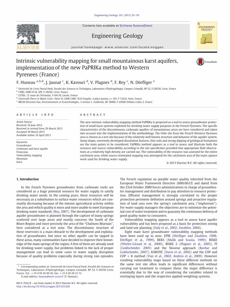
Fig. 1. Location of the spring and simplified geological map of the study area. The numbering of the tracing experiments refers to Table 5.
84 F. Huneau et al. / Engineering Geology 161 (2013) 81–93
to 1. The weighting values comply with an empirical rule, based onpersonal experience and judgment of the hydrogeologist (Kavouriet al., 2011), this rule considers that the global vulnerability is mainlyassociated with the two function criteria (I and Ka), for which thesum of the weights corresponds to 50–65% of the total weight, where-as the sum of the weights of the structure criteria (P and R) reaches
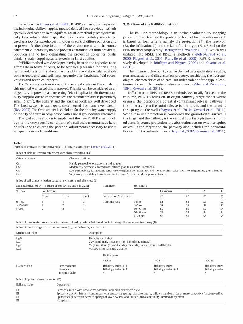
Fig. 2. Schematic cross section through the Orbe Sp
35–50%. More details about the rating equation can be found inKavouri et al. (2011).
Different weighting values combinations have to be tested, but thefinal intrinsic vulnerabilitymap has to be chosen according to the follow-ing rules: (i) all the most vulnerable karstic features (sinkholes, dolines,karrenfields) have to appear on the final map as “high sensitivity” areas,
ring aquifer system, modified from Rey (2007).
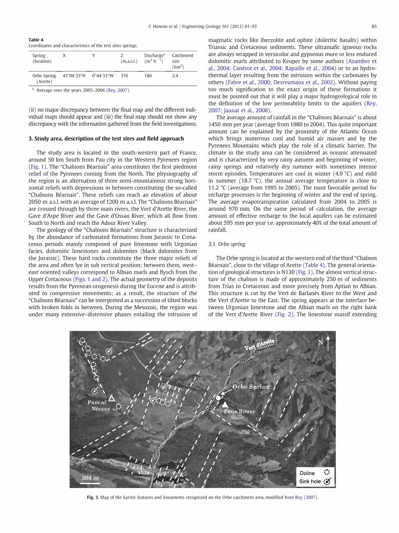
Table 4Coordinates and characteristics of the test sites springs.
Spring(location)
X Y Z(m.a.s.l.)
Dischargea
(m3 h−1)Catchmentsize(km2)
Orbe Spring(Arette)
43°04′23″N 0°44′33″W 376 180 2.4
a Average over the years 2005–2006 (Rey, 2007).
85F. Huneau et al. / Engineering Geology 161 (2013) 81–93
(ii) no major discrepancy between the final map and the different indi-vidual maps should appear and (iii) the final map should not show anydiscrepancy with the information gathered from the field investigations.
3. Study area, description of the test sites and field approach
The study area is located in the south-western part of France,around 50 km South from Pau city in the Western Pyrenees region(Fig. 1). The “Chaînons Béarnais” area constitutes the first piedmontrelief of the Pyrenees coming from the North. The physiography ofthe region is an alternation of three semi-mountainous strong hori-zontal reliefs with depressions in between constituting the so-called“Chaînons Béarnais”. These reliefs can reach an elevation of about2050 m a.s.l. with an average of 1200 m a.s.l. The “Chaînons Béarnais”are crossed through by three main rivers, the Vert d'Arette River, theGave d'Aspe River and the Gave d'Ossau River, which all flow fromSouth to North and reach the Adour River Valley.
The geology of the “Chaînons Béarnais” structure is characterizedby the abundance of carbonated formations from Jurassic to Creta-ceous periods mainly composed of pure limestone with Urgonianfacies, dolomitic limestones and dolomites (black dolomites fromthe Jurassic). These hard rocks constitute the three major reliefs ofthe area and often lye in sub vertical position; between them, west–east oriented valleys correspond to Albian marls and flysch from theUpper Cretaceous (Figs. 1 and 2). The actual geometry of the depositsresults from the Pyrenean orogenesis during the Eocene and is attrib-uted to compressive movements; as a result, the structure of the“Chaînons Béarnais” can be interpreted as a succession of tilted blockswith broken folds in between. During the Mesozoic, the region wasunder many extensive–distensive phases entailing the intrusion of
Fig. 3. Map of the karstic features and lineaments recognized
magmatic rocks like lherzolite and ophite (doleritic basalts) withinTriassic and Cretaceous sediments. These ultramafic igneous rocksare always wrapped in versicolor and gypseous more or less endureddolomitic marls attributed to Keuper by some authors (Azambre etal., 2004; Canérot et al., 2004; Rapaille et al., 2004) or to an hydro-thermal layer resulting from the intrusion within the carbonates byothers (Fabre et al., 2000; Desreumaux et al., 2002). Without payingtoo much signification to the exact origin of these formations itmust be pointed out that it will play a major hydrogeological role inthe definition of the low permeability limits to the aquifers (Rey,2007; Jaunat et al., 2008).
The average amount of rainfall in the “Chaînons Béarnais” is about1450 mm per year (average from 1980 to 2004). This quite importantamount can be explained by the proximity of the Atlantic Oceanwhich brings numerous cool and humid air masses and by thePyrenees Mountains which play the role of a climatic barrier. Theclimate in the study area can be considered as oceanic attenuatedand is characterized by very rainy autumn and beginning of winter,rainy springs and relatively dry summer with sometimes intensestorm episodes. Temperatures are cool in winter (4.9 °C) and mildin summer (18.7 °C), the annual average temperature is close to11.2 °C (average from 1995 to 2005). The most favorable period forrecharge processes is the beginning of winter and the end of spring.The average evapotranspiration calculated from 2004 to 2005 isaround 970 mm. On the same period of calculation, the averageamount of effective recharge to the local aquifers can be estimatedabout 595 mm per year i.e. approximately 40% of the total amount ofrainfall.
3.1. Orbe spring
The Orbe spring is located at the western end of the third “ChaînonBéarnais”, close to the village of Arette (Table 4). The general orienta-tion of geological structures is N130 (Fig. 1). The almost vertical struc-ture of the chaînon is made of approximately 250 m of sedimentsfrom Trias to Cretaceous and more precisely from Aptian to Albian.This structure is cut by the Vert de Barlanès River to the West andthe Vert d'Arette to the East. The spring appears at the interface be-tween Urgonian limestone and the Albian marls on the right bankof the Vert d'Arette River (Fig. 2). The limestone massif extending
on the Orbe catchment area, modified from Rey (2007).
86 F. Huneau et al. / Engineering Geology 161 (2013) 81–93
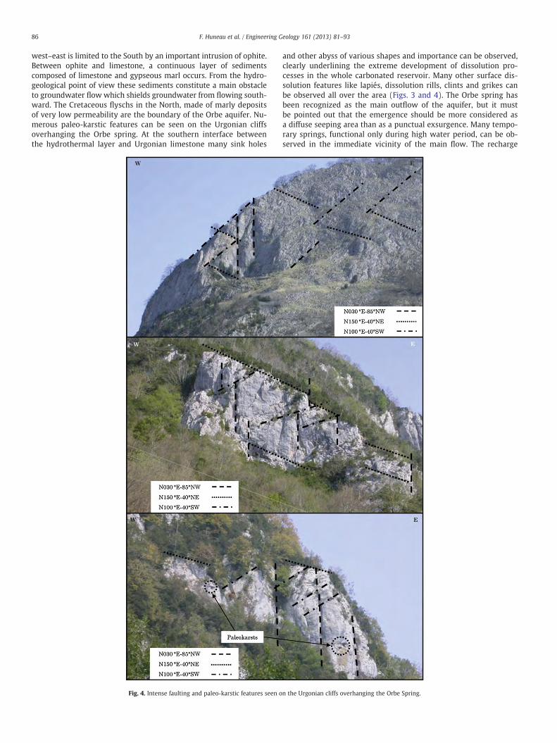
west–east is limited to the South by an important intrusion of ophite.Between ophite and limestone, a continuous layer of sedimentscomposed of limestone and gypseous marl occurs. From the hydro-geological point of view these sediments constitute a main obstacleto groundwater flow which shields groundwater from flowing south-ward. The Cretaceous flyschs in the North, made of marly depositsof very low permeability are the boundary of the Orbe aquifer. Nu-merous paleo-karstic features can be seen on the Urgonian cliffsoverhanging the Orbe spring. At the southern interface betweenthe hydrothermal layer and Urgonian limestone many sink holes
Fig. 4. Intense faulting and paleo-karstic features seen o
and other abyss of various shapes and importance can be observed,clearly underlining the extreme development of dissolution pro-cesses in the whole carbonated reservoir. Many other surface dis-solution features like lapiés, dissolution rills, clints and grikes canbe observed all over the area (Figs. 3 and 4). The Orbe spring hasbeen recognized as the main outflow of the aquifer, but it mustbe pointed out that the emergence should be more considered asa diffuse seeping area than as a punctual exsurgence. Many tempo-rary springs, functional only during high water period, can be ob-served in the immediate vicinity of the main flow. The recharge
n the Urgonian cliffs overhanging the Orbe Spring.
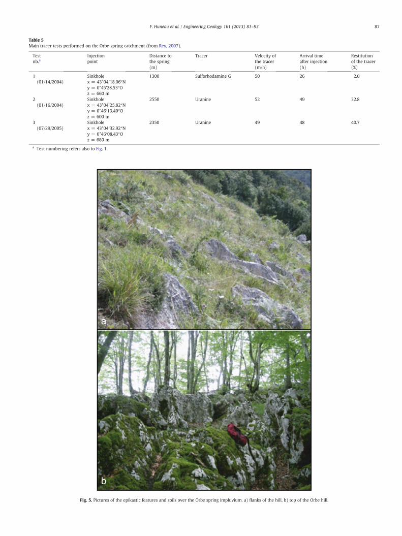
Table 5Main tracer tests performed on the Orbe spring catchment (from Rey, 2007).
Testnb.a
Injectionpoint
Distance tothe spring(m)
Tracer Velocity ofthe tracer(m/h)
Arrival timeafter injection(h)
Restitutionof the tracer(%)
1(01/14/2004)
Sinkholex = 43°04′18.06″Ny = 0°45’28.53″Oz = 660 m
1300 Sulforhodamine G 50 26 2.0
2(01/16/2004)
Sinkholex = 43°04′25.82″Ny = 0°46′13.40″Oz = 600 m
2550 Uranine 52 49 32.8
3(07/29/2005)
Sinkholex = 43°04′32.92″Ny = 0°46′08.43″Oz = 680 m
2350 Uranine 49 48 40.7
a Test numbering refers also to Fig. 1.
Fig. 5. Pictures of the epikastic features and soils over the Orbe spring impluvium. a) flanks of the hill, b) top of the Orbe hill.
87F. Huneau et al. / Engineering Geology 161 (2013) 81–93
88 F. Huneau et al. / Engineering Geology 161 (2013) 81–93
processes to the aquifer are mainly diffuse and the Orbe karst aqui-fer can be considered as an autogenic system with no relationshipwith the Vert d'Arette River (Rey, 2007). Detailed geophysical in-vestigations via electric prospecting have managed to localize amajor karstic conduit a few meters in depth close to Orbe spring,this conduit is supposed to be the main collector to the exsurgence(Rey, 2007).
Land uses over the study area are mostly rural with deciduousforests on the highest reliefs and pasture lands in the valleys. Soilsare mainly thin brown soils developed on carbonate rocks and mostof the time filling more or less developed lapiez.
Several dye tracer tests (uranine and sulforhodamine G) werecarried out from sinkholes at the interface between limestone andclay boundaries indicating for most of them a direct connectionbetween karst conduits to the Orbe spring (Rey, 2007). These dyetracer tests results are displayed on Table 5 and Fig. 1.
The Orbe spring is also the main water supply source of the city ofArette and is exploited since the 1950s for this purpose.
Over the field area, more than 100 spots have been selected,assessed, ranked and indexed according to the PaPRIKa methodology.Only 30 spots have been accurately geo-referenced because of techni-cal limitation of the GPS system caused by the density of the forestand steepness of the slopes. The major difficulty over the Orbe springcatchment area is the difficulty in terms of access to the differentparts of the catchment because of steep to very steep slopes and theabsence of passable roads.
E map
S map
1.5 km
1.5 km
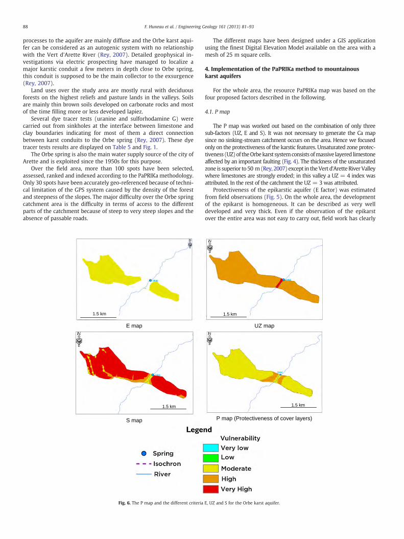
Fig. 6. The P map and the different criteria
The different maps have been designed under a GIS applicationusing the finest Digital Elevation Model available on the area with amesh of 25 m square cells.
4. Implementation of the PaPRIKa method to mountainouskarst aquifers
For the whole area, the resource PaPRIKa map was based on thefour proposed factors described in the following.
4.1. P map
The P map was worked out based on the combination of only threesub-factors (UZ, E and S). It was not necessary to generate the Ca mapsince no sinking-stream catchment occurs on the area. Hence we focusedonly on the protectiveness of the karstic features. Unsaturated zone protec-tiveness (UZ)of theOrbekarst systemconsists ofmassive layered limestoneaffected by an important faulting (Fig. 4). The thickness of the unsaturatedzone is superior to 50 m(Rey, 2007) except in theVert d'Arette RiverValleywhere limestones are strongly eroded; in this valley a UZ = 4 index wasattributed. In the rest of the catchment the UZ = 3 was attributed.
Protectiveness of the epikarstic aquifer (E factor) was estimatedfrom field observations (Fig. 5). On the whole area, the developmentof the epikarst is homogeneous. It can be described as very welldeveloped and very thick. Even if the observation of the epikarstover the entire area was not easy to carry out, field work has clearly
UZ map
P map (Protectiveness of cover layers)
1.5 km
1.5 km
E, UZ and S for the Orbe karst aquifer.
89F. Huneau et al. / Engineering Geology 161 (2013) 81–93
demonstrated the existence of the epikarst at any place within thecatchment area. In the vicinity of the Vert d'Arette River Valleysteep slopes the epikarst was not characterized and is omitted onthe E map. For the rest of the area, an E2 index was assigned. Evenif dissolution features like karrenfields are well developed over themajor part of the catchment area, which can be considered as adverseto the protection of the reservoir, the study carried out by Rey (2007)has clearly demonstrated the existence of a functional epikarst. Thebehavior of the epikarst is considered as complex and closely linkedto the hydrologic antecedent conditions of the system. Hence, theprotectiveness of the epikarst can be considered as maximum afterdry periods and minimum during the most rainy periods (Rey, 2007).
Finally, the protectiveness of the soil-cover factor (S) was assessed.Soil is rarely present at the Orbe karst surface and the contribution ofthis factor to the protection mapping is thus limited. An index of S4was then attributed. Where some soil was present and enough devel-oped like in the bottom of valleys or depressions a S2 or S3 index waschosen depending on the thickness of the soil layer (Fig. 5).
Maps of each sub-factors and the final P map are shown in Fig. 6.The most protective factor of each cell is represented on the final Pmap. In the case of the Orbe system it appears that the protectivenessof the epikarstic aquifer is largely dominant as also observed on othertest sites (Kavouri et al., 2011).
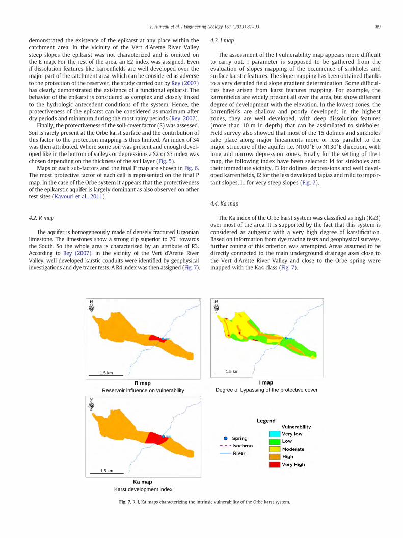
4.2. R map
The aquifer is homogeneously made of densely fractured Urgonianlimestone. The limestones show a strong dip superior to 70° towardsthe South. So the whole area is characterized by an attribute of R3.According to Rey (2007), in the vicinity of the Vert d'Arette RiverValley, well developed karstic conduits were identified by geophysicalinvestigations and dye tracer tests. A R4 indexwas then assigned (Fig. 7).
R mapReservoir influence on vulnerability
Ka map Karst development index
1.5 km
1.5 km
Fig. 7. R, I, Ka maps characterizing the intrins
4.3. I map
The assessment of the I vulnerability map appears more difficultto carry out. I parameter is supposed to be gathered from theevaluation of slopes mapping of the occurrence of sinkholes andsurface karstic features. The slopemapping has been obtained thanksto a very detailed field slope gradient determination. Some difficul-ties have arisen from karst features mapping. For example, thekarrenfields are widely present all over the area, but show differentdegree of development with the elevation. In the lowest zones, thekarrenfields are shallow and poorly developed; in the highestzones, they are well developed, with deep dissolution features(more than 10 m in depth) that can be assimilated to sinkholes.Field survey also showed that most of the 15 dolines and sinkholestake place along major lineaments more or less parallel to themajor structure of the aquifer i.e. N100°E to N130°E direction, withlong and narrow depression zones. Finally for the setting of the Imap, the following index have been selected: I4 for sinkholes andtheir immediate vicinity, I3 for dolines, depressions and well devel-oped karrenfields, I2 for the less developed lapiaz andmild to impor-tant slopes, I1 for very steep slopes (Fig. 7).
4.4. Ka map
The Ka index of the Orbe karst system was classified as high (Ka3)over most of the area. It is supported by the fact that this system isconsidered as autigenic with a very high degree of karstification.Based on information from dye tracing tests and geophysical surveys,further zoning of this criterion was attempted. Areas assumed to bedirectly connected to the main underground drainage axes close tothe Vert d'Arette River Valley and close to the Orbe spring weremapped with the Ka4 class (Fig. 7).
I mapDegree of bypassing of the protective cover
1.5 km
ic vulnerability of the Orbe karst system.
90 F. Huneau et al. / Engineering Geology 161 (2013) 81–93
5. The intrinsic vulnerability map of the resource
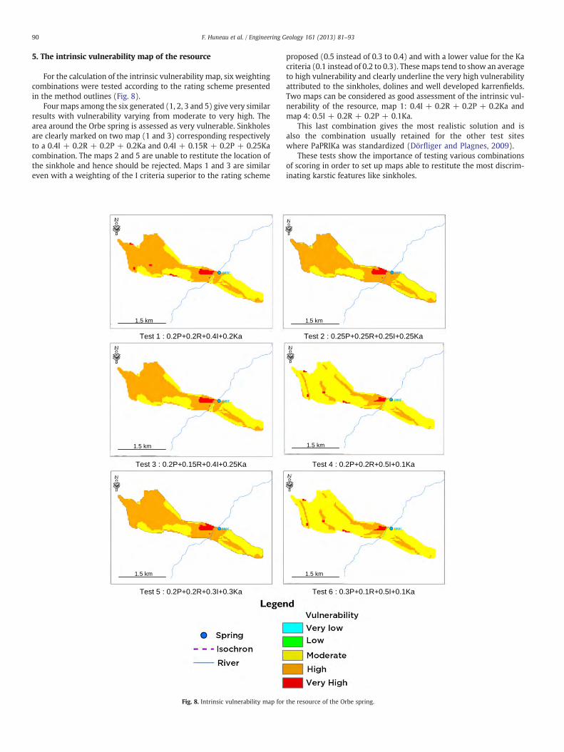
For the calculation of the intrinsic vulnerability map, six weightingcombinations were tested according to the rating scheme presentedin the method outlines (Fig. 8).
Fourmaps among the six generated (1, 2, 3 and 5) give very similarresults with vulnerability varying from moderate to very high. Thearea around the Orbe spring is assessed as very vulnerable. Sinkholesare clearly marked on two map (1 and 3) corresponding respectivelyto a 0.4I + 0.2R + 0.2P + 0.2Ka and 0.4I + 0.15R + 0.2P + 0.25Kacombination. The maps 2 and 5 are unable to restitute the location ofthe sinkhole and hence should be rejected. Maps 1 and 3 are similareven with a weighting of the I criteria superior to the rating scheme
Test 1 : 0.2P+0.2R+0.4I+0.2Ka
Test 3 : 0.2P+0.15R+0.4I+0.25Ka
Test 5 : 0.2P+0.2R+0.3I+0.3Ka
1.5 km
1.5 km
1.5 km
Fig. 8. Intrinsic vulnerability map for
proposed (0.5 instead of 0.3 to 0.4) and with a lower value for the Kacriteria (0.1 instead of 0.2 to 0.3). Thesemaps tend to show an averageto high vulnerability and clearly underline the very high vulnerabilityattributed to the sinkholes, dolines and well developed karrenfields.Two maps can be considered as good assessment of the intrinsic vul-nerability of the resource, map 1: 0.4I + 0.2R + 0.2P + 0.2Ka andmap 4: 0.5I + 0.2R + 0.2P + 0.1Ka.
This last combination gives the most realistic solution and isalso the combination usually retained for the other test siteswhere PaPRIKa was standardized (Dörfliger and Plagnes, 2009).
These tests show the importance of testing various combinationsof scoring in order to set up maps able to restitute the most discrim-inating karstic features like sinkholes.
Test 2 : 0.25P+0.25R+0.25I+0.25Ka
Test 4 : 0.2P+0.2R+0.5I+0.1Ka
Test 6 : 0.3P+0.1R+0.5I+0.1Ka
1.5 km
1.5 km
1.5 km
the resource of the Orbe spring.
Isource mapSource intrinsic vulnerability map
Rating : 0.4I+0.2R+0+2P+0.2Ka
12h
24h
36h
48h
1.5 km1.5 km
1.5 km 1.5 km
1.5 km 1.5 km
1.5 km1.5 km
Fig. 9. Isource maps and the corresponding source-vulnerability maps for the 4 isochrones (12, 24, 36, 48 h) considered by PaPRIKa methodology.
91F. Huneau et al. / Engineering Geology 161 (2013) 81–93
92 F. Huneau et al. / Engineering Geology 161 (2013) 81–93
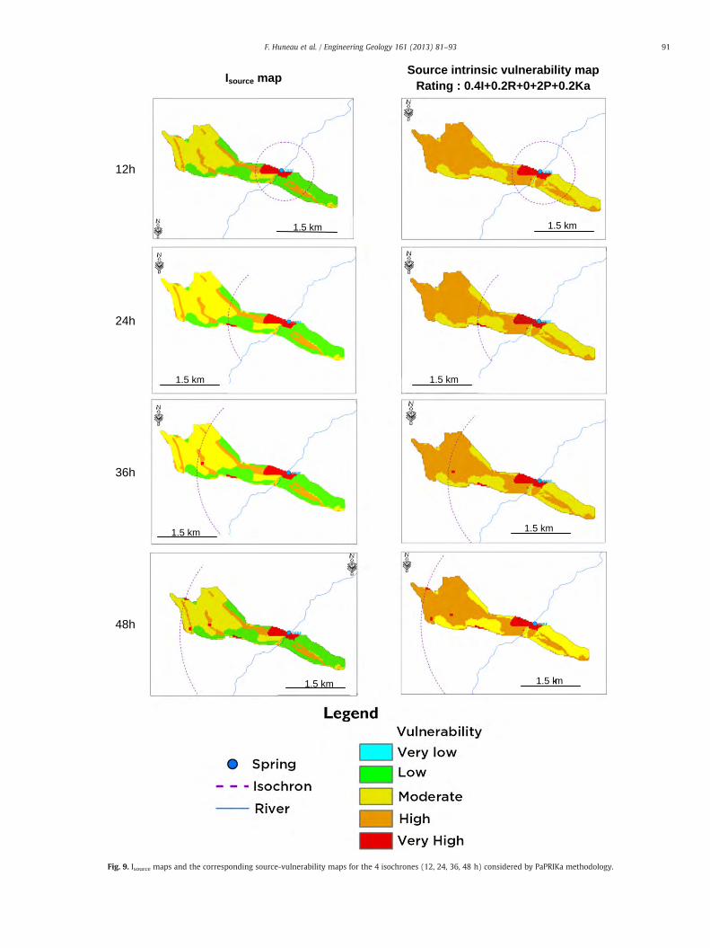
6. Spring vulnerability mapping
The intrinsic vulnerability for the capture work of the Orbe springwas also assessed. Four Isource maps have been generated consideringthe 12, 24, 36 and 48 h isochrones which were determined based onthe results of dye tracing tests carried out by Rey (2007). The Table 5displays the location and results of the main dye tracing tests avail-able for the Orbe spring catchment. Main karst conduits identifiedby geophysical investigations in the vicinity of the Vert d'AretteRiver are considered as highly vulnerable zones. The different tracertests carried out by Rey (2007) have clearly demonstrated theabsence of any noticeable hydraulic link between the Vert d'AretteRiver and the Orbe spring. Three dye tracing tests, all carried outduring high water stage, can be used to assess the Isource vulnerabilitymap (Table 5). These tests are located in the western part of thecatchment at a distance varying from 1 to 2.5 km from the Orbespring. The average velocity of groundwater within the system isabout 50 m/h for recovery percentages of the tracer up to 41%(Table 5). The different maps for the four isochrones are displayedon Fig. 9. One dye tracing test is also considered here but with avery low recovery rate of about 2% explained by adverse climaticconditions during the test (Rey, 2007). This latter has also proven ahydraulic link between the southern boundary sinkholes and theOrbe spring.
The pattern of the isochrones is based on the information providedby these three dye tracing tests, also considering that the recoveryrate of the dye tracing test no. 3 is higher (more than 40%). No dyetracing test is available for the right bank of the Vert d'Arette River.
The four intrinsic vulnerability maps generated for the Orbe springallows to distinguish 3 main classes of vulnerability and stronglyhighlights a very highly vulnerable area in the immediate vicinity ofthe spring. In this area the karst conduit network is very dense asrecognized by geophysical surveys. When the intervention time islonger than 12 h (Fig. 9), the sinkholes are integrated into the vulner-ability map of the spring. The vulnerability map generated for anintervention time of 48 h highlights the vulnerable areas around thesinkholes, areas that should be protected in priority for the sustain-able exploitation of the spring. These areas as well as the area imme-diately around the spring have to be protected and included into afirst class protection zone (immediate protection zone). The areawith highly vulnerable index will be classified as second class protec-tion zones (close protection zone) and the rest of the catchment areacan be considered as a third class protection zone (remote protectionzone) according to the French legislation on the protection zone ofdrinking water supply catchments.
These maps will help the stakeholders to propose the bestadapted-protection zoning to protect the catchment from accidentalpollution.
7. Conclusions
The new PaPRIKa method proposed by Kavouri et al. (2011), forresource and source-vulnerability mapping in karst aquifers hasbeen developed, updating previous specialized methods and takinginto consideration the European guidelines. The PaPRIKa method,designed for intrinsic vulnerability assessment, is based on structuraland hydraulic behavior factors according to karst conceptual modelproposed by Mangin (1975). It provides resource-vulnerability mapsas well as source-vulnerability maps by estimating the horizontaltravel time and modifying the I factor.
The factors P and R characterize the structure of the karst aquifer.The P factor combines various criteria such as soil cover, epikarsticaquifer, unsaturated zone and the surface stage of streamwater lossesin terms of water catchment. The characterization requires pedologicand geological data. The epikarstic aquifer is characterized usingfield outcrop observations as well as hydrogeological observations
(perched spring, wells in epikarst layers). This mapping is not easyand requires good hydrogeological field observations. The R factor isdetermined using a geological map and geological outcrop observa-tions, as well as a borehole database. This latter factor had to beadapted to the specific conditions of mountainous karst systems likeOrbe in the sense that the very steep character of the limestoneoutcropping and the important dipping of about 70° oriented in thedirection of the flow to the spring was considered as a major vulnera-bility factor. It was then necessary to considerer the R factor as highlyto very highly vulnerable over the whole impluvium.
The Ka and I factors characterize the system's hydraulic behavior.Even though the I factor is relatively easily determined using thedigital elevation model and field observations, the Ka factor requiresdetailed information related to discharge time series and physicaland chemical time series, as well as dye-tracer-test information anddata on the size and development of the karst conduit network. Ifall these detailed data are not available, which is often the case, themodel can be simplified. However, providing full explanations of thevalues chosen for the Ka factor remains essential (Kavouri et al.,2011).
As the Orbe spring is a relatively small mountainous karst system,it provided the opportunity to test the method in a spatially very dif-ferent context and hydrogeological environment, mainly because ofthe steep character of its impluvium. It appears that all the impluviumhas to be protected but different levels of protection can be organizedaccording the occurrence of important karst features like sinkholes ofmajor faulted areas around the spring. The highest level of protectionhas then to be maintained along the southern border of the Urgonianlimestone at the interface with the ophite intrusions since most of thesinkholes can be located in this area. This zone can be directly linkedto the immediate vicinity of the spring or considered as a satellitearea. An intermediate level of protection has to be guaranteed ofthe places where the epikarst is the most developed and can act asa direct transfer zone towards the saturated zone of the aquifer.
In the future, it is necessary to carry out further field investiga-tions, especially in terms of dye tracing tests, to allow a better estima-tion of the areas where the fastest circulations of groundwater areobserved.
Acknowledgments
This work was cofunded by the Adour-Garonne Water Agency.The authors would like to thank M. Pierre Marchet (Adour-GaronneWater Agency) for his interest and discussions. M. Aurélien Baro isalso thanked for the edition of the GIS maps.
References
Andreo, B., Ravbar, N., Vias, J.M., 2009. Source vulnerability mapping in carbonate(karst) aquifers by extension of the COP method: application to pilot sites. Hydro-geology Journal 17, 749–758.
Azambre, B., Rossy, M., Bossière, G., 2004. Commentaire à la note de Desreumaux et al.,intitulée Découverte de turbidites du Crétacé supérieur métamorphisées au con-tact d'intrusions d'ophites dans les Pyrénées occidentales (vallée d'Aspe, France).Vers une révision de l'âge des ophites pyrénéennes [C. R. Géoscience 334 (2002)197]. Discussion. Les dolérites tholéïtiques (« ophites ») sont-elles d'âge crétacéou triasico-liasiques ? Comptes Rendus Geosciences 336, 169–170.
Canérot, J., Majesté-Menjoulàs, C., Ternet, Y., 2004. Nouvelle interprétation de la « faillenord-pyrénéenne » en vallée d'Aspe (Pyrénées-Atlantiques). Remise en questiond'un plutonisme ophitique danien dans le secteur de Bedos. Comptes RendusGeosciences 336, 135–142.
Daly, D., Dassargues, A., Drew, D., Dunne, S., Goldscheider, N., Neale, S., Popescu, I.C.,Zwahlen, F., 2002. Main concepts of the European approach to karst–groundwatervulnerability assessment and mapping. Hydrogeology Journal 10, 340–345.
Davis, A.D., Long, A.J., Wireman, M., 2002. KARSTIC: a sensitive method for carbonateaquifers in karst terrain. Environmental Geology 42, 65–72.
Desreumaux, C., Clément, B., Fabre, R., Martins-Campina, B., 2002. Découverte de turbi-dites du Crétacé supérieur métamorphisées au contact d'intrusions d'ophites dansles Pyrénées occidentales (vallée d'Aspe, France). Vers une révision de l'âge desophites pyrénéennes. Comptes Rendus Geosciences 334, 1–7.
93F. Huneau et al. / Engineering Geology 161 (2013) 81–93
Dörfliger, N., Plagnes, V., 2009. Cartographie de la vulnérabilité intrinsèque des aquiferskarstiques, guide méthodologique de la method PaPRIKa. Tech. Report BRGM/RP-57527-FR (105 pp.).
Dörfliger, N., Zwahlen, F., 1998. Practical guide: groundwater vulnerability mapping inkarstic regions (EPIK). Environment in practice. Swiss Agency for the Environment,Forests and Landscape (SAEFL), Bern (56 pp.).
Dörfliger, N., Jeannin, P.Y., Zwahlen, F., 1999. Water vulnerability assessment in karstenvironments: a new method of defining protection areas using a multi-attributeapproach and GIS tools (EPIK method). Environmental Geology 39, 165–176.
Fabre, R., Desreumaux, C., Lebourg, T., 2000. Les glissements rocheux du versant sud duLayens (Vallée d'Aspe, Pyrénées occidentales). Bulletin de la Societe Geologique deFrance 171, 407–418.
Goldscheider, N., 2005. Karst groundwater vulnerability mapping: application of a newmethod in the Swabian Alb, Germany. Hydrogeology Journal 13, 555–564.
Jaunat, J., Huneau, F., Rey, F., Pretou, F., 2008. Application de lamethod RISKE2 aux sourcesd'Ourtau et de la fontaine d'Orbe, cartographie de la vulnérabilité intrinsèque des aqui-fers karstiques. Tech. Report n°2008-027. University of Bordeaux-1, France (135 pp.).
Kavouri, K., Plagnes, V., Tremoulet, J., Dörfliger, N., Reijiba, F., Marchet, P., 2011. PaPRI-KA: a method for estimating karst resource and source vulnerability—applicationto the Ouysse karst system (southwest France). Hydrogeology Journal 19, 339–353.
Malik, P., Svasta, J., 1999. REKS: an alternative method of karst groundwater vulnerabil-ity estimation. Hydrogeology and land use management. Proceeding of the XXIXCongress of the International Association of Hydrogeologists, Bratislava, Slovakia,pp. 79–85.
Mangin, A., 1975. Contribution à l'étude hydrodynamique des aquifères karstiques.University of Dijon, France (PhD Thesis).
Pételet-Giraud, E., Dörfliger, N., Crochet, P., 2000. RISKE: méthode d'évaluationmulticritère de la vulnérabilité des aquifères karstiques. Application aux systèmesdes Fontanilles et Cent-Fonts (Hérault, Sud de la France). Hydrogéologie 4, 71–88.
Plagnes, V., Théry, S., Fontaine, L., Bakalowicz, M., Dörfliger, N., 2005. Karst vulnerabilitymapping: improvement of the RISKE method. KARST 2005, Water Resources
and Environmental Problems in Karst, 14–19 September 2005 Belgrade-Kotor,Serbia.
Plagnes, V., Kavouri, K., Huneau, F., Fournier, M., Jaunat, J., Pinto-Ferreira, C., Leroy,B., Marchet, P., Dörfliger, N., 2010. PaPRIKa, the French multicriteria method tomap the intrinsic vulnerability of karst water resource and source: two exam-ples (Pyrénées, Normandy). In: Andreo, B., et al. (Ed.), Advances in Research inKarst Media. Springer, Heidelberg, pp. 323–329. http://dx.doi.org/10.1007/978-3-642-12486-0_50.
Pranville, J., Plagnes, V., Rejiba, F., Trémoulet, J., 2008. Cartographie de la vulnérabilitésur la partie sud du causse de Gramat: application de la méthode RISKE 2. Géologues156, 44–48.
Rapaille, C., Betrand, H., Marzoli, A., 2004. Commentaire à la note de ChristianDesreumaux et al. Intitulée: Découverte de turbidites du Crétacé supérieurmétamorphisées au contact d'intrusions d'ophites dans les Pyrénées occidentales(vallée d'Aspe, France). Vers une révision de l'âge des ophites pyrénéennes [C. R.Géoscience 334 (2002) 197]. Comptes Rendus Geosciences 336, 171–172.
Ravbar, N., Goldscheider, N., 2007. Proposed methodology of vulnerability and contam-ination risk mapping for the protection of karst aquifers in Slovenia. Acta Carsol 36,461–475.
Rey, F., 2007. Ressources en eau souterraine dans les chaînons béarnaise (Pyrénées-Atlantiques, France), géométrie et fonctionnement hydrogéologique de quatreaquifères carbonates. University of Bordeaux-1, France (PhD Thesis).
Vias, J.M., Andreo, B., Peles, M.J., Carrasco, F., Vadillo, I., Jimenez, P., 2002. Preliminary pro-posal of a method for vulnerability mapping in carbonate aquifers. In: Carrasco, F.,Duran, J.J., Andreo, B. (Eds.), Karst and environment. 2nd Nerja Cave GeologicalSymp., Nerja, Spain, pp. 75–83.
Vrba, J., Zaporozec, A., 1994. Guidebook on mapping groundwater vulnerability. Inter-national Contributions to Hydrogeology 16.Heise, Hannover, Germany (131 pp.).
Zwahlen, F., 2004. COST Action 620: vulnerability and risk mapping for the protectionof carbonate (Karst) Aquifers. Final report.European Water Framework Directive,European Commission, Brussels (297 pp.).